Hywind Scotland Pilot Park Project Phase 1 Intertidal Survey Report Statoil ASA Assignment Number: A100142-S00 Document Number: A-100142-S00-REPT-009 Xodus Group Ltd The Auction House 63A George St Edinburgh EH2 2JG UK T +44 (0)131 510 1010 E [email protected]www.xodusgroup.com
Transcript
Hywind Scotland Pilot Park Project Phase 1 Intertidal Survey Report
Hywind Scotland Pilot Park Project – Phase 1 Intertidal Survey Report Assignment Number: A100142-S00 Document Number: A-100142-S00-REPT-009 iii
Table of Contents
EXECUTIVE SUMMARY 4
1 INTRODUCTION 5
2 METHODOLOGY 6
3 DESK-BASED ASSESSMENT RESULTS 7
3.1 Methodology 7
3.2 Protected sites 7
3.3 Biodiversity Action Plans 7
3.3.1 The UK Biodiversity Action Plan (UK BAP) 7
3.3.2 North-east Scotland Local Biodiversity Action Plan (LBAP) 7
3.4 Species and habitats records 8
3.4.1 Existing records 8
3.4.2 Review of photographs from the geotechnical walkover survey already conducted for the Project 8
4 SURVEY RESULTS 11
4.1 Survey conditions 11
4.2 Biotope mapping 11
4.2.1 Biotopes recorded 11
4.2.2 Subsidiary biotopes 11
4.3 General site overview 17
4.3.1 Horseback to The Ive 17
4.3.2 The Gadle 18
4.3.3 Cargeddie 19
4.3.4 White Stane, Red Stane and the Skirrie 19
4.4 Other noteworthy observations 20
5 SUMMARY AND RECOMMENDATIONS 21
6 REFERENCES 22
APPENDIX A INTERTIDAL BIOTOPES 23
Hywind Scotland Pilot Park Project – Phase 1 Intertidal Survey Report Assignment Number: A100142-S00 Document Number: A-100142-S00-REPT-009 4
EXECUTIVE SUMMARY
To support the development of the Hywind Scotland Pilot Park Project (‘the Project’), Statoil Wind Limited (SWL) is undertaking an Environmental Impact Assessment (EIA). Part of the EIA will involve the assessment of potential impacts on intertidal ecology, related to the proposed onshore cable route options at Peterhead.
To inform the EIA and to evaluate the potential for impacts on intertidal ecology, SWL has appointed Xodus Group to undertake a marine intertidal Phase 1 biotope mapping survey. The aim of the survey was to characterise and map baseline ecological conditions within the survey area. At the time of the survey three potential locations for bringing the export cable ashore (cable landfall) were under consideration within the intertidal survey area: one located across the mouth of the River Ugie in the north; one at the sandy bay at The Ive in the middle of the survey area; and another to the south of the survey area adjacent to the harbour sea defences.
Prior to the survey a desk-based assessment was undertaken to identify habitats and species including protected habitats and species likely to be present in the survey area.
The intertidal survey identified 16 main biotopes and four subsidiary biotopes including biotopes dominated by lichens, fucoids, barnacles, kelp, calcareous red algae in rock pools and ephemeral green algae. The distribution of biotopes across the site relates to a range of physical factors including substrate type, degree of exposure to wave action, height on the shore and modifiers such as salinity and sand scour. The spatial extent of the intertidal zone and topography varied throughout the survey area, creating a mosaic of biotopes. Biotopes were broadly similar across the site, although local conditions e.g. sand and freshwater influence, and geology, resulted in differences in the zonation patterns on the shore and therefore the presence and extent of biotopes.
Rockpool biotopes were present throughout the site and were also present in discrete mappable areas in places. Rockpools are considered specialised biotopes of particular nature conservation interest because they are often species-rich and therefore increase the biodiversity of the shore. The north-east Scotland Biodiversity Action Plan (BAP) has a Principle Target of ‘no loss, or reduction in quality, of existing estuarine and intertidal habitat’. For these reasons it is recommended that the species-rich rockpool areas are avoided and that mitigation measures are implemented to minimise intertidal impacts. Best working practice guidance, including that provided in the CIRIA coastal and marine environmental site guide (CIRCA, 2003) and the SEPA Pollution Prevention Guidelines (PPG) (SEPA, 2013), should be followed to minimise disturbance to intertidal habitats.
Hywind Scotland Pilot Park Project – Phase 1 Intertidal Survey Report Assignment Number: A100142-S00 Document Number: A-100142-S00-REPT-009 5
1 INTRODUCTION
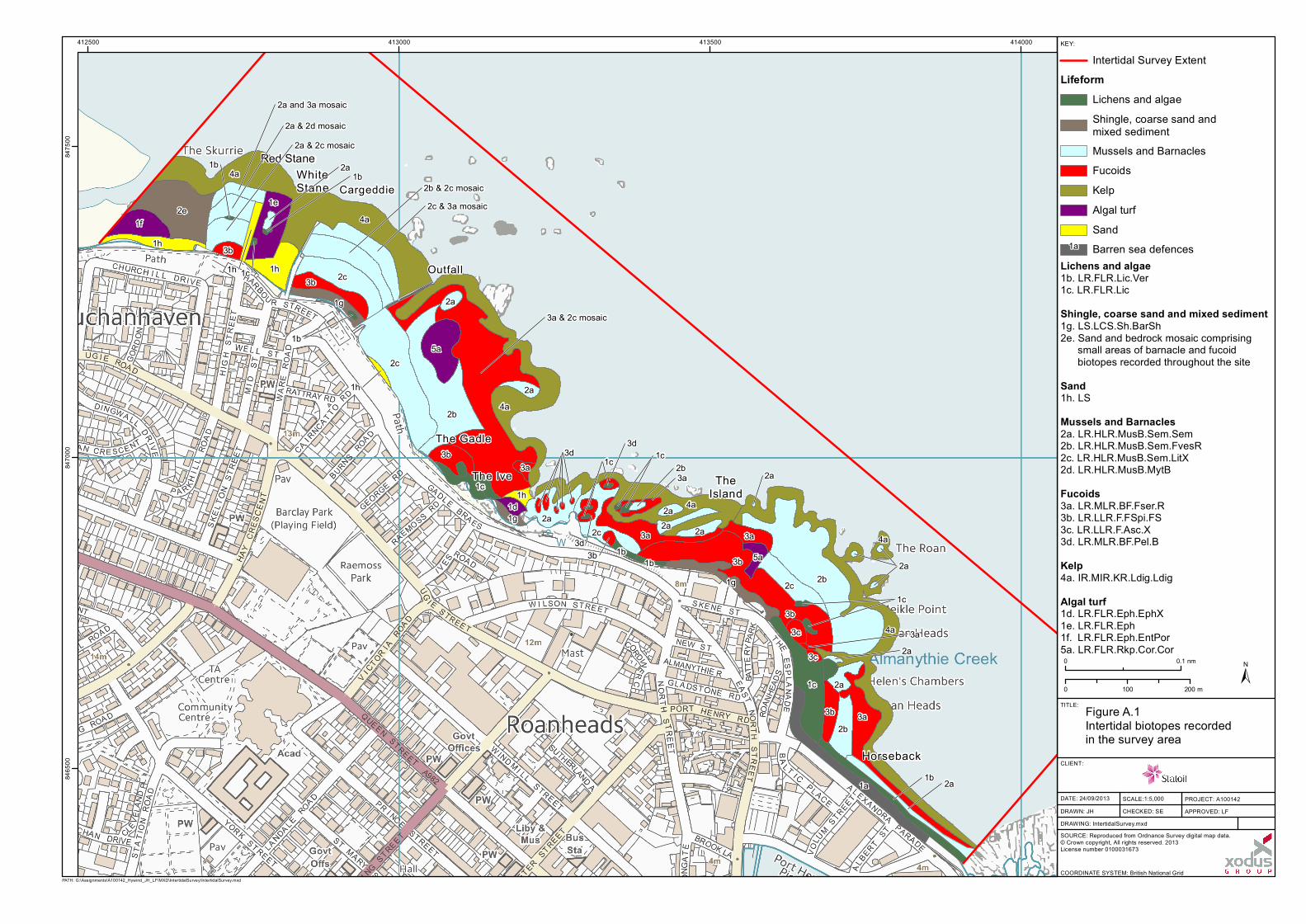
A marine intertidal Phase 1 biotope mapping survey was undertaken on behalf of Statoil Wind Limited (SWL) during August 2013 to map the intertidal (eulittoral) biotopes within the coastal area being considered for the export cable route landfall for the Hywind Scotland Pilot Park Project (‘Project’). The area surveyed, as shown in Figure A.1, extends approximately 1.5 km from Buchanhaven in the north, where the River Ugie discharges to sea, to the sea defences located at the North Harbour in the south.
The aim of the survey was to characterise and map baseline ecological conditions within the survey area to enable accurate assessment and to identify potential for impacts of the Project on intertidal ecology. The survey area has not been the subject of any previous intertidal biotope mapping. However, a study of the River Ugie was undertaken by Bennett and McLeod (1998). The desk-based assessment undertaken to support the survey (Section 3) cited a lack of available biodiversity records for the area and also described the site based on photographic material collected during a geotechnical walkover survey. The desk-based assessment was used to describe the site, to determine whether any habitats and species of conservation value were likely to be present and to determine the types of biotopes likely to be present within the survey area.
Hywind Scotland Pilot Park Project – Phase 1 Intertidal Survey Report Assignment Number: A100142-S00 Document Number: A-100142-S00-REPT-009 6
2 METHODOLOGY
The intertidal survey was carried out in accordance with the marine intertidal Phase 1 biotope mapping survey methodology as described by Wyn et al. (2000). This method is a standardised system of surveying and mapping littoral habitats. It is a rapid survey technique designed to produce illustrative maps of biotope distribution. The methodology advises that surveys are undertaken between April and October and during spring tides to offer the most complete results in terms of both the amount of growth on the shore and the extent of the intertidal exposed during low tide periods. Biotope mapping of soft sediments within the survey area was not included within the survey scope. These areas are, however, indicated on the biotope map as appropriate.
The surveyors walked along the shore to identify, differentiate and map the extent of biotopes. The survey was undertaken during a window of four hours (i.e. two hours either side of low tide); however, it was possible to survey three hours before and after low water due to the shore topography.
The mosaic of biotope data collected in the field was transferred onto a Geographical Information System (GIS) and colour-coded in accordance with the standard colour scheme described in the survey manual (Wyn et al., 2000).
Hywind Scotland Pilot Park Project – Phase 1 Intertidal Survey Report Assignment Number: A100142-S00 Document Number: A-100142-S00-REPT-009 7
3 DESK-BASED ASSESSMENT RESULTS
3.1 Methodology
A detailed desk-based assessment was undertaken to establish background information to inform and guide the intertidal field survey. Data sources consulted as part of this assessment included:
>>>> Multi Agency Geographic Information for the Countryside (MAGIC) website (magic.defra.gov.uk);
>>>> National Biodiversity Network (NBN) gateway website (www.nbn.org.uk);
>>>> Coasts and Seas of the United Kingdom Region 3 North-east Scotland: Cape Wrath to St. Cyrus (Barne et al., 1996); and
>>>> Photographs taken during a geotechnical walkover survey in July 2013 (Xodus, 2013).
3.2 Protected sites
The survey area is not located within any international or national protected sites. The nearest protected site is the Buchan Ness to Collieston Coast Special Protection Area (SPA) approximately 2 km to the south of the intertidal survey area. There are no protected sites for intertidal habitats or species within 20 km of the intertidal survey area.
3.3 Biodiversity Action Plans
3.3.1 The UK Biodiversity Action Plan (UK BAP)
The UK BAP was published in 1994 as a response by the UK Government to the Convention on Biological Diversity which the UK signed up to in 1992 in Rio de Janeiro. It describes the biological resources of the UK and provides detailed plans for conservation of these resources, at both national and local levels. Action plans for the most threatened species and habitats have been set out to aid recovery, and reporting rounds every three to five years show how the UK BAP has contributed to the UK’s progress towards the significant reduction of biodiversity loss called for by the Convention on Biological Diversity. The UK BAP encompasses over 160 Local Biodiversity Action Plans (Local BAPs), which highlight local priorities for biodiversity and conservation and work to deliver agreed actions and targets for priority habitats and species and locally important wildlife and sites.
Priority species and habitats are those that have been identified as being the most threatened and requiring conservation action under the UK BAP. Following a review in August 2007, the UK BAP priority list contained 1,150 species and 65 habitats. Although the UK Biodiversity Framework published in 2012 supersedes the UK BAP, the priority species and habitats agreed under UK BAP still form much of the basis of the new framework.
3.3.2 North-east Scotland Local Biodiversity Action Plan (LBAP)
The north-east Scotland LBAP includes a specific local habitat action plan for estuarine and intertidal habitats (NESB, 2004), which includes the following important habitats:
>>>> Estuaries;
>>>> Coastal saltmarsh;
>>>> Seagrass beds;
>>>> Mudflats;
Hywind Scotland Pilot Park Project – Phase 1 Intertidal Survey Report Assignment Number: A100142-S00 Document Number: A-100142-S00-REPT-009 8
>>>> Sheltered muddy gravel; and
>>>> Littoral rock.
Of these habitats, littoral rock was identified as being the most likely to be found in the survey area.
The UK biodiversity objectives and proposed targets for littoral rock are ‘to maintain the extent and quality of littoral rocky habitats in the UK, including the full diversity of communities’.
The objectives and proposed targets for littoral rock habitat set out in the north-east Scotland LBAP are:
>>>> Principal Objective
o To maintain, enhance and rejuvenate the quality, extent and status of the estuarine and intertidal habitats in north-east Scotland through appropriate habitat management, data collection, promotion, education, liaison and legislation.
>>>> Principal Target
o No loss, or reduction in quality, of existing estuarine and intertidal habitat.
3.4 Species and habitats records
3.4.1 Existing records
There are very few existing records of the intertidal environment within or close to the survey area. Bennett and McLeod (1998) described the River Ugie, the mouth of which enters the intertidal survey area, as supporting an abundance of the fucoid Fucus ceranoides.
A species and habitats records request to the North East Biological Records Centre (NESBReC) did not indicate the presence of any intertidal species records identified under Annex I of the Habitats Directive, UKBAP or north-east Scotland LBAP. A high level integrated habitat system of littoral rock was identified within the intertidal survey area (NESBReC, 2013).
3.4.2 Review of photographs from the geotechnical walkover survey already conducted for the Project
In July 2013, as part of the Xodus Geotechnical Support Services Scope of Work for the Project, a geotechnical walk over survey was conducted over the same area as the intertidal survey area (Xodus, 2013). A high level review of the photographs taken during this survey has been conducted to give an indication of the likely habitats, species and biotopes present in the survey area.
The whole of the intertidal area would be categorised largely as an open coast physiographic type, with a littoral width ranging from 100 – 1,000 m. It faces largely north-east, and is exposed to moderately-exposed.
The whole of the intertidal area is mostly backed by a man-made coastal wall and to the south, along Horseback (see Figure A.1), this is further supported by sea defences. There is also a Scottish Water outfall pipe bisecting the whole of the shore and a small stone pier towards Buchanhaven in the north of the survey area.
From the photographs, the majority of the intertidal habitat appears to be rock with occasional rockpools in the south, progressing to less bed rock and more large boulders to the centre. There are occasional patches of barren cobbles and boulders at the high shore, especially in the centre of the survey area. In the north of the survey area, on approach to the mouth of the River Ugie, smaller boulders and eventually sand begins to dominate the littoral habitat, with outcrops of rock.
Some of the possible biotopes (based on Connor et al., 2004 classifications) observed across the majority of the survey area include those characterised by:
>>>> Lichens in the supra littoral and upper littoral fringe (e.g. LR.FLR.Lic.YG, LR.FLR.Lic.Ver, LR.FLR.Lic.Ver.B, LR.FLR.Lic.Ver.Ver.);
Hywind Scotland Pilot Park Project – Phase 1 Intertidal Survey Report Assignment Number: A100142-S00 Document Number: A-100142-S00-REPT-009 9
>>>> Barnacle dominated communities in the upper and mid shore (e.g. LR.HLR.MusB.Cht, LR.HLR.MusB.Cht.Cht, LR.HLR.MusB.Sem, LR.HLR.MusB.Sem); and
>>>> Fucoid and kelps in the lower shore (e.g. IR.MIR.KR.Ldig.Ldig, IR.MIR.KR.Ldig.Bo)i.
Towards the northern section of the survey area, including on the stone Buchnahaven pier and amongst the sand, ephemeral green algae can be seen, possibly indicating the possible presence of the biotopes LR.FLR.Eph.Eph.Ent or LR.FLR.Eph.EphX.
Species observed from the photographs include:
i Full descriptions of the biotopes observed during the survey are presented in Table 4.1
>>>> Alaria esculentus;
>>>> Barnacle sp;
>>>> Corallina officinalis;
>>>> Corallinaceae crusts (pools);
>>>> Enteromorpha sp;
>>>> Fucus serratus;
>>>> Halidrys siliquosa;
>>>> Littorina littorea;
>>>> Patella sp;
>>>> Porphyra spp.;
>>>> Laminaria digitata;
>>>> Ulva sp;
>>>> Verrucaria maura; and
>>>> Yellow lichens.
Although it is not possible to identify from the photographs taken during the geotechnical walkover survey, there is potential for some of the specialist biotopes described by Wyn et al. (2000) to be present within the intertidal survey area. These include rockpool and underboulder community biotopes.
A selection of photographs taken during the geotechnical survey is presented in Table 3.1.
Hywind Scotland Pilot Park Project – Phase 1 Intertidal Survey Report Assignment Number: A100142-S00 Document Number: A-100142-S00-REPT-009 10
Table 3.1 Selection of photos taken during the geotechnical walk over survey conducted in July 2013 (Xodus, 2013)
Southern section, coastal defences (background) and upper shore yellow and black lichens and rockpools.
Southern to middle of the survey area, mid shore bed rock dominated by barnacles and occasional rockpools.
Bedrock shore with cobbles and boulders in the upper supralittoral.
Middle to northern shore, bedrock progressing to large boulders. Dominated by barnacles in mid shore and kelp in lower shore. Ephemeral green algae on Buchanhaven stone pier.
Mixed bedrock and boulder shore with rockpools.
In the north of the survey area on approach to the mouth of the River Ugie, sand begins to dominate the littoral habitat, with outcrops of rock.
Hywind Scotland Pilot Park Project – Phase 1 Intertidal Survey Report Assignment Number: A100142-S00 Document Number: A-100142-S00-REPT-009 11
4 SURVEY RESULTS
4.1 Survey conditions
The survey was undertaken by Andrea Taylor (B.Sc. Marine Biology, MCIEEM) and Polly Tarrant (B.Sc. Marine Biology, MCIEEM) on the 22
nd and 23
rd of August during a period of spring low tides. Low water on these days was
predicted to be 0.3 m at 08:21 a.m. and 0.4 m at 09:00 a.m. respectively.
Weather conditions during the survey period were humid with fog and mist, with some fine rain on the morning of the 22
nd. Visibility and light conditions were generally poor during first light when the fog was thickest. Conditions
improved as the day progressed. Access to the site was gained from public highways and stairways from the sea wall to the shore. Egress from the shore was limited to points with stairways due to the inaccessibility of the sea wall defence.
4.2 Biotope mapping
Biotopes are the basic mapping units for intertidal survey and are biological communities based on conspicuous plants or algae and animals, together with the physical characteristics of their habitat:
>>>> Substratum;
>>>> Wave exposure;
>>>> Tidal stream; and
>>>> Modifiers such as sand scour and freshwater runoff (Hiscock, 1996).
The biotopes present therefore reflect the physical characteristics of the littoral zone.
4.2.1 Biotopes recorded
A total of 16 main biotopes and four subsidiary biotopes were identified from six lifeform groups. The main biotopes recorded are shown in Figure A.1 and listed in Table 4.1 along with notes on species recorded, their standard codes (Connor et al., 2004) and lifeform groups. Photographs of biotopes recorded are shown in Table A.1.
4.2.2 Subsidiary biotopes
Four subsidiary biotopes occurred throughout the survey area; in areas either not large enough to map or associated with different biotopes at different tidal levels. Table 4.2 outlines these biotopes and their occurrence throughout the survey area, but they are not displayed on Figure A.1.
The exception to this is coralline algae rockpool biotope LR.FLR.Rkp.Cor.Cor. This biotope occurred throughout the mid to low shore in relatively small pools, but was also present in large mappable pools in the north and the south of the site as shown in Figure A.1. Rockpool biotopes are considered specialised biotopes (Wyn et al., 2000), of particular nature conservation interest because they are often species-rich and therefore increase the biodiversity of the shore (Wyn et al., 2000). Rockpools (in addition to other features and criteria) are described as biotopes for additional consideration in the Site of Special Scientific Interest (SSSI) Guidelines (JNCC, 1996).
Hywind Scotland Pilot Park Project – Phase 1 Intertidal Survey Report Assignment Number: A100142-S00 Document Number: A-100142-S00-REPT-009 12
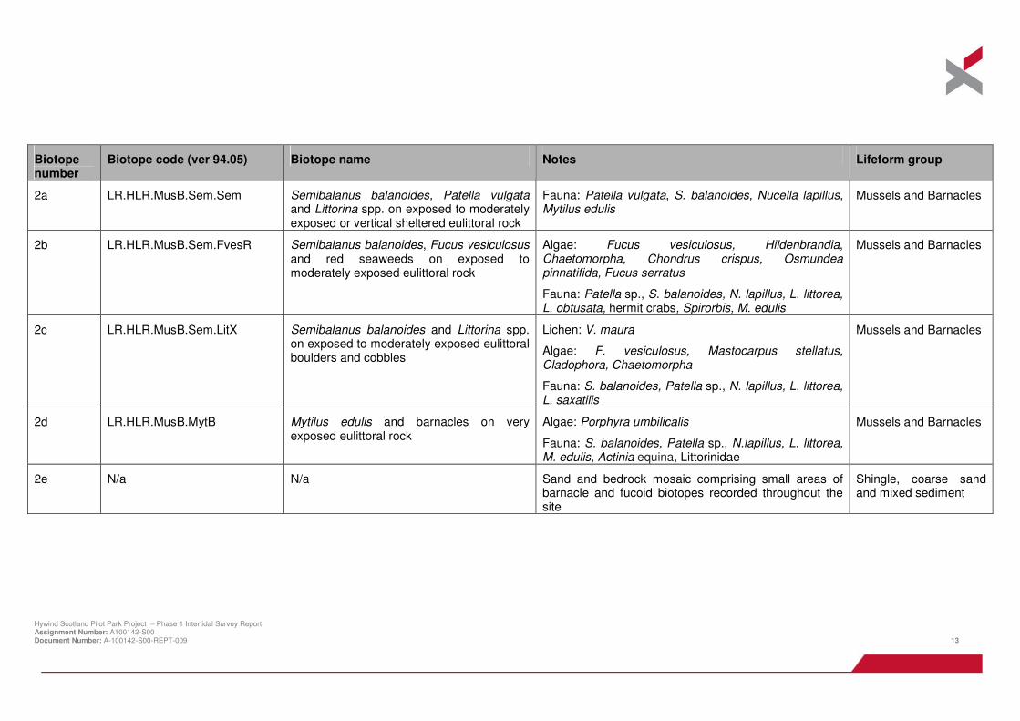
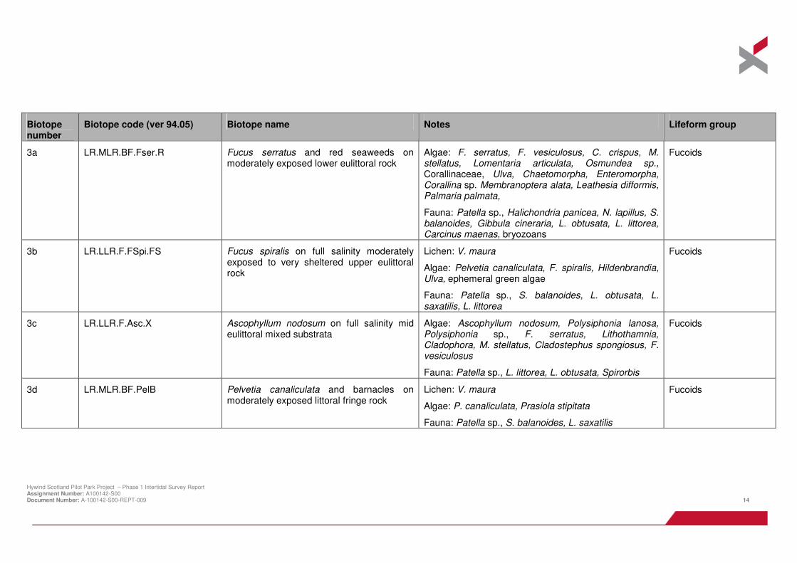
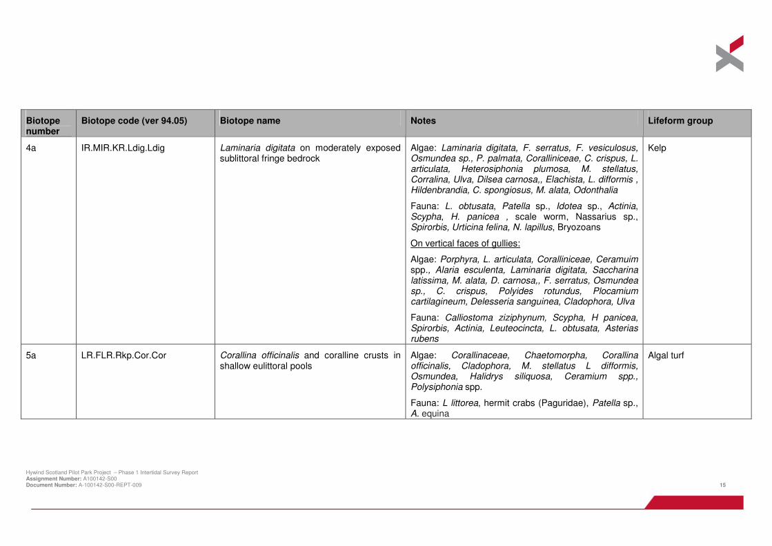
Table 4.1 Phase 1 biotopes present within the survey area
Biotope number
Biotope code (ver 94.05) Biotope name Notes Lifeform group
1a N/a N/a Barren sea defences N/a
1b LR.FLR.Lic.Ver Verrucaria maura on littoral fringe rock Lichen: Verrucaria maura
Algae: Porphyra sp., Ulva sp.
Fauna: Littorina saxatilis, Patella vulgata
Lichens and algae
1c LR.FLR.Lic Lichens or small green algae on supralittoral rock
Lichen: V. maura, Xanthoria sp., Caloplaca sp., grey lichens
Algae: Prasiola stipitata, ephemeral green algae, Porphyra sp., Pelvetia canaliculata
Fauna: L. saxatilis, Actinia, Littorina littorea, Patella sp.
Lichens and algae
1d LR.FLR.Eph.EphX Ephemeral green and red seaweeds on variable salinity and/or disturbed eulittoral mixed substrata
Algae: Enteromorpha
Algal turf
1e LR.FLR.Eph Ephemeral green or red seaweeds (freshwater of sand-influenced)
Algae: Enteromorpha, Ulva
Fauna: Semibalanus balanoides, Patella sp. L. littorea
Algal turf
1f LR.FLR.Eph.EntPor Porphyra purpurea and Enteromorpha spp. on sand –scoured mid or lower eulittoral rock
Hywind Scotland Pilot Park Project – Phase 1 Intertidal Survey Report Assignment Number: A100142-S00 Document Number: A-100142-S00-REPT-009 13
Biotope number
Biotope code (ver 94.05) Biotope name Notes Lifeform group
2a LR.HLR.MusB.Sem.Sem Semibalanus balanoides, Patella vulgata and Littorina spp. on exposed to moderately exposed or vertical sheltered eulittoral rock
Fauna: Patella vulgata, S. balanoides, Nucella lapillus, Mytilus edulis
Mussels and Barnacles
2b LR.HLR.MusB.Sem.FvesR Semibalanus balanoides, Fucus vesiculosus and red seaweeds on exposed to moderately exposed eulittoral rock
Fauna: Patella sp., S. balanoides, N. lapillus, L. littorea, L. obtusata, hermit crabs, Spirorbis, M. edulis
Mussels and Barnacles
2c LR.HLR.MusB.Sem.LitX Semibalanus balanoides and Littorina spp. on exposed to moderately exposed eulittoral boulders and cobbles
Lichen: V. maura
Algae: F. vesiculosus, Mastocarpus stellatus, Cladophora, Chaetomorpha
Fauna: S. balanoides, Patella sp., N. lapillus, L. littorea, L. saxatilis
Mussels and Barnacles
2d LR.HLR.MusB.MytB Mytilus edulis and barnacles on very exposed eulittoral rock
Algae: Porphyra umbilicalis
Fauna: S. balanoides, Patella sp., N.lapillus, L. littorea, M. edulis, Actinia equina, Littorinidae
Mussels and Barnacles
2e N/a N/a Sand and bedrock mosaic comprising small areas of barnacle and fucoid biotopes recorded throughout the site
Shingle, coarse sand and mixed sediment
Hywind Scotland Pilot Park Project – Phase 1 Intertidal Survey Report Assignment Number: A100142-S00 Document Number: A-100142-S00-REPT-009 14
Biotope number
Biotope code (ver 94.05) Biotope name Notes Lifeform group
3a LR.MLR.BF.Fser.R Fucus serratus and red seaweeds on moderately exposed lower eulittoral rock
Algae: F. serratus, F. vesiculosus, C. crispus, M. stellatus, Lomentaria articulata, Osmundea sp., Corallinaceae, Ulva, Chaetomorpha, Enteromorpha, Corallina sp. Membranoptera alata, Leathesia difformis, Palmaria palmata,
Fauna: Patella sp., Halichondria panicea, N. lapillus, S. balanoides, Gibbula cineraria, L. obtusata, L. littorea, Carcinus maenas, bryozoans
Fucoids
3b LR.LLR.F.FSpi.FS Fucus spiralis on full salinity moderately exposed to very sheltered upper eulittoral rock
Lichen: V. maura
Algae: Pelvetia canaliculata, F. spiralis, Hildenbrandia, Ulva, ephemeral green algae
Fauna: Patella sp., S. balanoides, L. obtusata, L. saxatilis, L. littorea
Fucoids
3c LR.LLR.F.Asc.X Ascophyllum nodosum on full salinity mid eulittoral mixed substrata
Algae: Ascophyllum nodosum, Polysiphonia lanosa, Polysiphonia sp., F. serratus, Lithothamnia, Cladophora, M. stellatus, Cladostephus spongiosus, F. vesiculosus
Fauna: Patella sp., L. littorea, L. obtusata, Spirorbis
Fucoids
3d LR.MLR.BF.PelB Pelvetia canaliculata and barnacles on moderately exposed littoral fringe rock
Lichen: V. maura
Algae: P. canaliculata, Prasiola stipitata
Fauna: Patella sp., S. balanoides, L. saxatilis
Fucoids
Hywind Scotland Pilot Park Project – Phase 1 Intertidal Survey Report Assignment Number: A100142-S00 Document Number: A-100142-S00-REPT-009 15
Biotope number
Biotope code (ver 94.05) Biotope name Notes Lifeform group
4a IR.MIR.KR.Ldig.Ldig Laminaria digitata on moderately exposed sublittoral fringe bedrock
Algae: Laminaria digitata, F. serratus, F. vesiculosus, Osmundea sp., P. palmata, Coralliniceae, C. crispus, L. articulata, Heterosiphonia plumosa, M. stellatus, Corralina, Ulva, Dilsea carnosa,, Elachista, L. difformis , Hildenbrandia, C. spongiosus, M. alata, Odonthalia
Fauna: L. obtusata, Patella sp., Idotea sp., Actinia, Scypha, H. panicea , scale worm, Nassarius sp., Spirorbis, Urticina felina, N. lapillus, Bryozoans
On vertical faces of gullies:
Algae: Porphyra, L. articulata, Coralliniceae, Ceramuim spp., Alaria esculenta, Laminaria digitata, Saccharina latissima, M. alata, D. carnosa,, F. serratus, Osmundea sp., C. crispus, Polyides rotundus, Plocamium cartilagineum, Delesseria sanguinea, Cladophora, Ulva
Fauna: Calliostoma ziziphynum, Scypha, H panicea, Spirorbis, Actinia, Leuteocincta, L. obtusata, Asterias rubens
Kelp
5a LR.FLR.Rkp.Cor.Cor Corallina officinalis and coralline crusts in shallow eulittoral pools
Algae: Corallinaceae, Chaetomorpha, Corallina officinalis, Cladophora, M. stellatus L difformis, Osmundea, Halidrys siliquosa, Ceramium spp., Polysiphonia spp.
Fauna: L littorea, hermit crabs (Paguridae), Patella sp., A. equina
Algal turf
Hywind Scotland Pilot Park Project – Phase 1 Intertidal Survey Report Assignment Number: A100142-S00 Document Number: A-100142-S00-REPT-009 16
Table 4.2 Subsidiary biotopes present within the survey area
Biotope code (ver 94.05)
Biotope name Occurrence Species notes
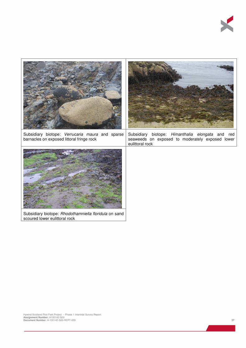
LR.FLR.Lic.Ver.B Verrucaria maura and sparse barnacles on exposed littoral fringe rock
Observed high shore in the littoral fringe in the amongst the biotope LR.FLR.Lic
Lichen: V. maura
Fauna: S. balanoides, P. vulgata, L. saxatilis
LR.FLR.Rkp.Cor.Cor Corallina officinalis and coralline crusts in shallow eulittoral pools
Observed throughout the mid to low shore in relatively small pools, associated with the F. vesiculosus and F. serratus biotopes A.LR.MLR.BF.Fser.R and LR.HLR.MusB.Sem.FvesR but was also present in large mappable pools.
As 5a above in Table 4.2
LR.HLR.FR.Him Himanthalia elongata and red seaweeds on exposed to moderately exposed lower eulittoral rock
Observed in the low shore on bedrock platforms above the biotopes LR.MLR.BF.Fser.R and IR.MIR.KR.Ldig.Ldig
Algae: Himanthalia elongata, Osmundea, M. stellatus, F. serratus
Fauna: S. balanoides, Patella sp., N. lapillus
LR.MLR.BF.Rho Rhodothamniella floridula on sand scoured lower eulittoral rock Observed throughout the site north of ‘The Ive’ associated with the F. vesiculosus and F. serratus biotopes LR.HLR.MusB.Sem.FvesR and LR.MLR.BF.Fser.R
Algae: Rhodothamniella floridula, Porphyra, Ulva, F. serratus, C. crispus, L. articluta, M. stellatus, Elachista
Fauna: H. panicea
Hywind Scotland Pilot Park Project – Phase 1 Intertidal Survey Report Assignment Number: A100142-S00 Document Number: A-100142-S00-REPT-009 17
4.3 General site overview
The topography and wave exposure of the site varies across the entire intertidal survey area. The southern part (Horseback to Ive) and the very northern part of the survey area (towards the mouth of the River Ugie) are composed of elevated and steep bedrock. The middle part of the survey area (the Gadle) is composed of lower lying bedrock in the upper and mid shore, with elevated steep bedrock only present in the low shore where patches of boulders and cobble are present amongst bedrock. The patchwork of topography creates variable levels of wave exposure throughout the site, therefore creating a mosaic of substrates and subsequent biotopes, particularly fucoid and barnacle biotopes. In areas with a more extensive intertidal area, particularly in the north of the site, more space is available to support mid-shore biotopes such as the F. vesiculosus and barnacle biotope LR.HLR.MusB.Sem.FvesR.
Rockpools of varying sizes and supporting a range of communities were present throughout the high shore to the low shore. In the high shore, pools tended to support high numbers of Actinia sp. and were dominated by coralline crusts. Pools with ephemeral green algae were also present in the high shore. In the mid shore, the pools were of the type LR.FLR.Rkp.Cor.Cor, sometimes overgrown with green algae and with very high L. littorea abundances. In the low shore, large pools were dominated by fucoids and kelp (mainly L. digitata with some Alaria esculenta individuals).
Boulders and cobbles, and bedrock with barnacles and Littorina spp, identified as the biotope LR.HLR.MusB.Sem.LitX, was recorded throughout the survey area.
The biotope mapping described below has been divided into four sections based on the broadly similar topography and/or biotopes present in these areas. Each of the four sections are generally described from south to north (unless identified noted).
4.3.1 Horseback to The Ive
Area overview
This section of the survey area extends from the sea defences the vicinity of Green Hill and North Harbour in the south of the site to the sand patch at ‘The Ive’. The flora and fauna present were impoverished in the high and mid-shore levels, but diversity increased in the low shore where the Fucus and kelp biotopes LR.MLR.BF.Fser.R and IR.MIR.KR.Ldig.Ldig were present. A dense red algae understorey was present throughout the mid and low shore areas associated with F. vesiculosus, F. serratus and L. digitata.
The majority of the natural intertidal environment in this section of the survey area is bedrock with some patches of cobble and small boulders interspersed through all tidal levels. High shore pools supporting high numbers of Actinia sp. and dominated by Corraline crusts were present. In the mid shore, rockpools with coralline algae (biotope LR.FLR.Rkp.Cor.Cor) were present.
The bedrock occasionally sloped steeply thereby creating areas characteristic of high-shore and in some cases mid-shore biotopes across the entire intertidal extent. For example, V. maura was present from the high shore to the low shore on elevated bedrock, and mid shore biotopes dominated spatially where the intertidal zone was wide enough to support additional biotopes.
Top shore
At the top of the shore, lichens or small green algae assigned to the biotope LR.FLR.Lic were present with yellow and grey lichens and V. maura. On the uppermost surface of supralittoral bedrock there were small patches of Prasiola stipitata indicating localised areas of enrichment due to the use of this area by seabirds. There were also some areas of barren cobble and shingle towards the middle of this section.
Mid shore to shallow infralittoral
The mid shore biotopes in this section were highly variable, related to the topography and the variation in wave exposure. In the south of this section, below the lichens or small green algae biotopes LR.FLR.Lic, the F.spiralis
Hywind Scotland Pilot Park Project – Phase 1 Intertidal Survey Report Assignment Number: A100142-S00 Document Number: A-100142-S00-REPT-009 18
biotope LR.LLR.F.FSpi.FS was present, followed by the S. balanoides and F. vesiculosus biotope, LR.MLR.BF.Fser.R and the kelp Laminaria digitata biotope IR.MIR.KR.Ldig.Ldig in the shallow infralittoral.
Key features
The ‘Almanythie Creek’ is a deep gully extending from the low shore to the mid shore. The creek supported the L. digitata kelp biotope IR.MIR.KR.Ldig.Ldig along its length before it was replaced by the F. serratus and red seaweed biotope LR.MLR.BF.Fser.R in the upper mid shore. Shelving bedrock in the low shore was recorded to support the Himanthalia elongata and red seaweeds subsidiary biotope LR.HLR.FR.Him. North of the creek the width of the intertidal increased to support extensive areas of barnacle dominated biotopes including LR.HLR.MusB.Sem.FvesR and LR.HLR.MusB.Sem.LitX. The barnacle and Littorina spp. biotope LR.HLR.MusB.Sem.LitX was present on bedrock in this area; however, it was also present on boulders and cobbles in other sections in the north. In sheltered areas the F. spiralis biotope LR.LLR.F.FSpi.FS was still present higher up the shore. A small area dominated by Ascophyllum nodosum, corresponding to the biotope LR.LLR.F.Asc.X, was recorded at the head of the creek.
In the middle of this section, in the mid shore, the geology of the site changed and was characterised by a large area of coralline algal rock pools (LR.FLR.Rkp.Cor.Cor). At the time of the site visit these pools were overgrown by the green algae Chaetomorpha spp. This green algae was recorded throughout the whole of the survey area in pools in the high to mid shore.
In the north of this area there is a feature called ‘The Island’. Here, an island of bedrock is created by two deep channels cut into the bedrock at either side. In the mid shore, F. spiralis (LR.LLR.F.FSpi.FS) became less prevalent and was replaced by barnacles and other gastropods (P. vulgata and Littorina spp), identified as the biotopes LR.HLR.MusB.Sem.Sem and LR.HLR.MusB.Sem.LitX. There are a number of large rock pinnacles in this area adjacent to ‘The Ive’. The tops of the rock pinnacles supported lichens or small green algae (LR.FLR.Lic) and the fucoid Pelvetia canaliculata with barnacles as biotope LR.MLR.BF.PelB with the aforementioned barnacle biotopes at the mid shore level. In flatter areas, F. serratus with an understory of red seaweeds (LR.MLR.BF.Fser.R) was present in the mid shore, which then gave way to the kelp L. digitata biotope, IR.MIR.KR.Ldig.Ldig, in the infralittoral fringe.
4.3.2 The Gadle
Area overview
This section of the survey area extends from the sand patch at ‘The Ive’ to the Scottish Water pipeline and outfall to the north. The topography in this section was much more uniform than that present in the south. Fewer elevated bedrock areas were present at the lower shore and there were not as many steeply sloping bedrock faces. There were some areas of elevated bedrock at the low water area on which the barnacles with the biotope LR.HLR.MusB.Sem.Sem were found. The mid shore region was much more extensive than further south and was dominated by barnacle biotopes as described below.
Detailed description
In the supralittoral at the sand patch at ‘The Ive’ was an area of barren cobble and boulders with a narrow band of ephemeral green and red seaweeds, assigned the biotope LR.FLR.Eph.EphX, below. The rest of this area was comprised of littoral sediments. Adjacent to this sand patch was a small area of lichens LR.FLR.Lic present on elevated steep bedrock. In the high shore adjacent to these lichens was also a discrete area of F. spiralis which was assigned the biotope LR.LLR.F.FSpi.FS. The rest of the high and mid shore in this area to the north was then dominated by barnacle biotopes.
In the north of this area, boulders and cobbles on the upper shore were colonised by S. balanoides and Littorina spp., with L. saxatilis at the top of the shore and L. littorea lower. This was assigned the biotope LR.HLR.MusB.Sem.LitX. The mid and low shore comprised of a mosaic kelps and barnacles assigned the biotopes LR.MLR.BF.Fser.R and LR.HLR.MusB.Sem.LitX in the lower mid shore and LR.HLR.MusB.Sem.FvesR in the upper mid shore. The kelp L. digitata biotope IR.MIR.KR.Ldig.Ldig dominated the low shore and also formed a finger of kelp alongside the outfall pipeline from the low to the mid shore.
Hywind Scotland Pilot Park Project – Phase 1 Intertidal Survey Report Assignment Number: A100142-S00 Document Number: A-100142-S00-REPT-009 19
Key features
To the north of this section, in the mid shore, there was a large area of rockpools dominated by coralline algae and assigned to the biotope LR.FLR.Rkp.Cor.Cor. The pools contained high abundances of L. littorea and were also overgrown by Chaetomorpha sp.
Sand-coured rock, colonised by the filamentous red alga Rhodothamniella floridula alongside other red and green algae such as C. crispus, L. articluta and M. stellatus was found in this area associated with the fucoid biotopes LR.HLR.MusB.Sem.FvesR and LR.MLR.BF.Fser.R. These areas were assigned the subsidiary biotope LR.MLR.BF.Rho.
4.3.3 Cargeddie
Area overview and description
This section of the survey area extends from the Scottish Water pipeline and outfall in the south to the Buchanhaven Harbour Pier in the north. This small area is relatively uniform and low lying and was dominated again by a mosaic of barnacle biotopes. At the top of the shore F. spiralis, LR.LLR.F.FSpi.FS, formed a band below barren boulders and shingle. Below the F. spiralis zone followed a succession of barnacle and fucoid biotopes before kelp IR.MIR.KR.Ldig.Ldig dominated in the low shore. The mid shore barnacle and fucoid biotopes were composed of LR.HLR.MusB.Sem.LitX, a mosaic of LR.HLR.MusB.Sem.LitX and LR.HLR.MusB.Sem.FvesR and a mosaic of LR.HLR.MusB.Sem.LitX and LR.MLR.BF.Fser.R.
Key features
Sand-scoured rock colonised by the filamentous red alga R. floridula was also found in this area, associated with the F, serratus and red seaweed biotope LR.MLR.BF.Fser.R. These areas were also assigned the subsidiary biotope LR.MLR.BF.Rho. In littoral sediment patches interspersed between bedrock and boulders was evidence of polychaetes including Arenicola marina and Lanice conchilega.
Ephemeral green algae were present in higher abundances in this section and were recorded adjacent to the outfall and throughout the barnacle and Fucus vesiculosus biotope LR.HLR.MusB.Sem.FvesR. Where ephemeral green algae were present adjacent to the outfall there was also a higher incidence of other kelps including small A. esculenta and L. saccharina plants. Mytilus edulis were also observed in cracks and crevices in bedrock and in rockpools.
4.3.4 White Stane, Red Stane and the Skirrie
Area overview and description
This section of the survey area extends from the Buchanhaven Harbour Pier in the east to the northern limit of the survey area where the River Ugie discharges into the sea. The geology and topography of this section is different to the previous areas surveyed. Adjacent to the Buchanhaven pier was an area of littoral sediment with ephemeral green algae and kelps in the low water. Freshwater or sand-influenced ephemeral green algae (LR.FLR.Eph) occurred on both littoral sediment and littoral rock in this area. The low water was dominated by kelps with the biotope IR.MIR.KR.Ldig.Ldig; however, as was observed in the previous survey section, a higher incidence of small A. esculenta and L. saccharina plants were present where green ephemeral algae were present.
A mosaic of barnacle biotopes again dominated the shore:
>>>> In the high shore, a mosaic of LR.HLR.MusB.Sem.Sem and LR.HLR.MusB.Sem.LitX;
>>>> In the mid shore, a mosaic of LR.HLR.MusB.Sem.Sem and LR.HLR.MusB.MytB; and
>>>> In the low shore, LR.HLR.MusB.Sem.Sem and LR.MLR.BF.Fser.R
To the west of the bedrock was an area of sand interspersed with small bedrock pinnacles. The biotopes present were a mosaic of the barnacle and fucoid biotopes already described and have not been mapped in detail. Within
Hywind Scotland Pilot Park Project – Phase 1 Intertidal Survey Report Assignment Number: A100142-S00 Document Number: A-100142-S00-REPT-009 20
the area of influence of the River Ugie the bedrock pinnacles supported a different community comprising of Porphyra purpurea and Enteromorpha (LR.FLR.Eph.EntPor). The bladderless form of F. vesiculosus was present on the uppermost surfaces of the rock pinnacles.
4.4 Other noteworthy observations
A single grey seal was observed on the morning of the 22nd
August 2013 in the vicinity of ‘The Roan’.
Seabirds including gulls and cormorants/shags were observed on elevated bedrock throughout the site but were most abundant in the low shore. A large flock of unidentified waders was present on the shore between ‘The Ive’ in the south and the Scottish Water outfall in the north.
Hywind Scotland Pilot Park Project – Phase 1 Intertidal Survey Report Assignment Number: A100142-S00 Document Number: A-100142-S00-REPT-009 21
5 SUMMARY AND RECOMMENDATIONS
The results of the intertidal survey provide a baseline description of the rocky littoral habitats around Peterhead. The biotopes present are a reflection of the physical characteristic of the shoreline and vary depending on the degree of exposure. The topography of the coast varies, with areas of exposed elevated rock outcrops in the low shore, sheltered enclosed areas of mixed sediment in the high shore and large extents of bedrock in the mid shore supporting a mosaic of barnacle and fucoid biotopes. The survey area is complex and highly variable with steeply sloping bedrock at all tidal levels and in some cases creating significant rock pinnacles.
The exposed shore and rock outcrops across the whole of the survey area were dominated by barnacles S. balanoides and limpets P.vulgata , which in the north of the survey area, were accompanied by mussels M. edulis. The periwinkle L. littorea is conspicuous on the more sheltered barnacle biotopes. Most of the survey extent comprises a mosaic of barnacle and fucoid biotopes. Fucoids with an understorey of turf forming red algae and rock pools dominated by encrusting corraline algae dominate the less elevated areas.
Zonation is variable throughout the site. At the top of the shore yellow and grey lichens are present in patches with the black lichen V. maura present throughout the site and tidal range. Patches of the green alga P. stipitata are present on elevated rock frequently by seabirds. F. spiralis was the most abundant species in the high shore, although P. canaliculata was found alongside it on areas of elevated rock with steep faces in the north of the survey area. The mid shore is highly variable with F. vesiculosus, F. serratus and barnacle biotopes dominating in different areas of the shore. In the mid to low shore, fucoid biotopes were dominated by F. serratus with an understorey of turf forming red algae often occurring as a wide band on flatter areas. However, on the more common steep rock faces in the mid to low shore, barnacle biotopes dominated.
Rockpool biotopes were found throughout the site and also form distinct mappable areas in the north and south of the site. Corraline and encusting red algae dominated the pools with fucoid and other brown and red algae. In some cases the pools were overgrown by the green algae Chaetomorpha spp. and supported high abundances of L. littorea. The sand binding alga, R. floridula, was recorded through the F. vesiculosus and F. serratus biotopes in the north of the site in the section of the Gadle.
Rockpool biotopes were present throughout the site and were also present in discrete mappable areas in places. Rockpools are considered specialised biotopes of particular nature conservation interest because they are often species-rich and therefore increase the biodiversity of the shore. The north-east Scotland Biodiversity Action Plan has a Principle Target of ‘no loss, or reduction in quality, of existing estuarine and intertidal habitat’. For these reasons it is recommended that species rich rockpool areas are avoided and that mitigation measures are implemented to minimise intertidal impacts. Best working practice guidance including that provided in the CIRIA coastal and marine environmental site guide (CRICA, 2003) and the SEPA Pollution Prevention Guidelines (PPG) (SEPA, 2013) should be followed to minimise disturbance to intertidal habitats.
Hywind Scotland Pilot Park Project – Phase 1 Intertidal Survey Report Assignment Number: A100142-S00 Document Number: A-100142-S00-REPT-009 22
6 REFERENCES
Barne, J.H., Robson, C.F., Kaznowska, S.S., Doody, J.P., & Davidson, N.C. (1996) Coasts and seas of the United Kingdom. Region 3 North-east Scotland: Cape Wrath to St. Cyrus. Peterborough, Joint Nature Conservation Committee. (Coastal Directories Series.)
Bennett, T.L. & McLeod, C.R. (1998) East Scotland (Duncansby Head to Dunbar) (MNCR Sector 4). In: Marine Nature Conservation Review. Benthic marine ecosystems of Great Britain and the north-east Atlantic, ed. by K. Hiscock, 123–154. Peterborough, Joint Nature Conservation Committee. (Coasts and seas of the United Kingdom. MNCR series).
CIRCA (2003) Coastal and marine environmental site guide – ISBN: 0 86017 584 7 Construction Industry Research and Information Association (CIRIA) Publication C584 Published February 2003
Connor, D.W., Allen, J.H., Golding, N., Howell, K.L., Lieberknecht, L.M., Northen, K.O. and Beker, J.B. (2004) The marine habitat classification for Britain and Ireland. Version 04.05 JNCC. Peterborough. ISBN 1 81 07561 8.
Hiscock, K. (ed) (1996) Marine Nature Conservation Review: rationale and methods. Peterborough, JNCC. (Coasts and Seas of the United Kingdom. MNCR Series.
JNCC (1996) Guidelines for selection of biological SSSIs: intertidal marine habitats and saline lagoons. Peterborough.
NESB (2004) North East Scotland Biodiversity. Final Consultation Draft. August 2004 Estuarine and Intertidal Habitats Local Habitat Action Plan.
NESBReC (2013) Designated species records within Peterhead. 14th August 2013. Reference
SEPA (2013). Pollution Prevention Guidelines. July 2013. Available online at http://www.sepa.org.uk/about_us/publications/guidance/ppgs.aspx
Wyn, G., Brazier, P., Birch, K., Bunker, A., Cooke, A., Jones, M., Lough, N., McMath, A. & Roberts, S. (2000) Handbook for Marine Intertidal Phase 1 Biotope Mapping Survey. Countryside Council for Wales, Bangor. ISBN 1 86169 144 0.
Xodus (2013) Geotechnical Support Services - Hywind Scotland Offshore Windfarm. Landfall Site Walkover - Geotechnical Evaluation. Report A-100142-S01-TECH-001
Hywind Scotland Pilot Park Project – Phase 1 Intertidal Survey Report Assignment Number: A100142-S00 Document Number: A-100142-S00-REPT-009 23
APPENDIX A INTERTIDAL BIOTOPES
Table A.1 Representative images of intertidal biotopes in the survey area
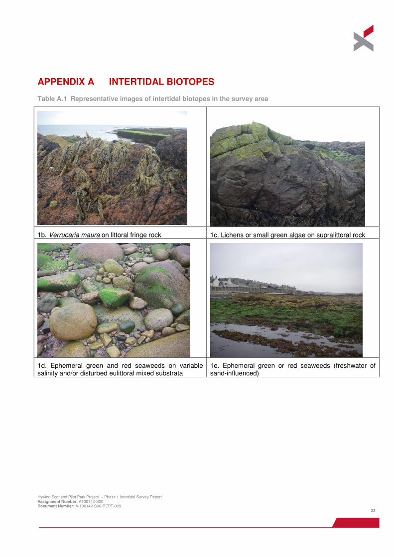
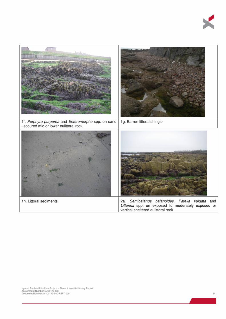
1b. Verrucaria maura on littoral fringe rock 1c. Lichens or small green algae on supralittoral rock
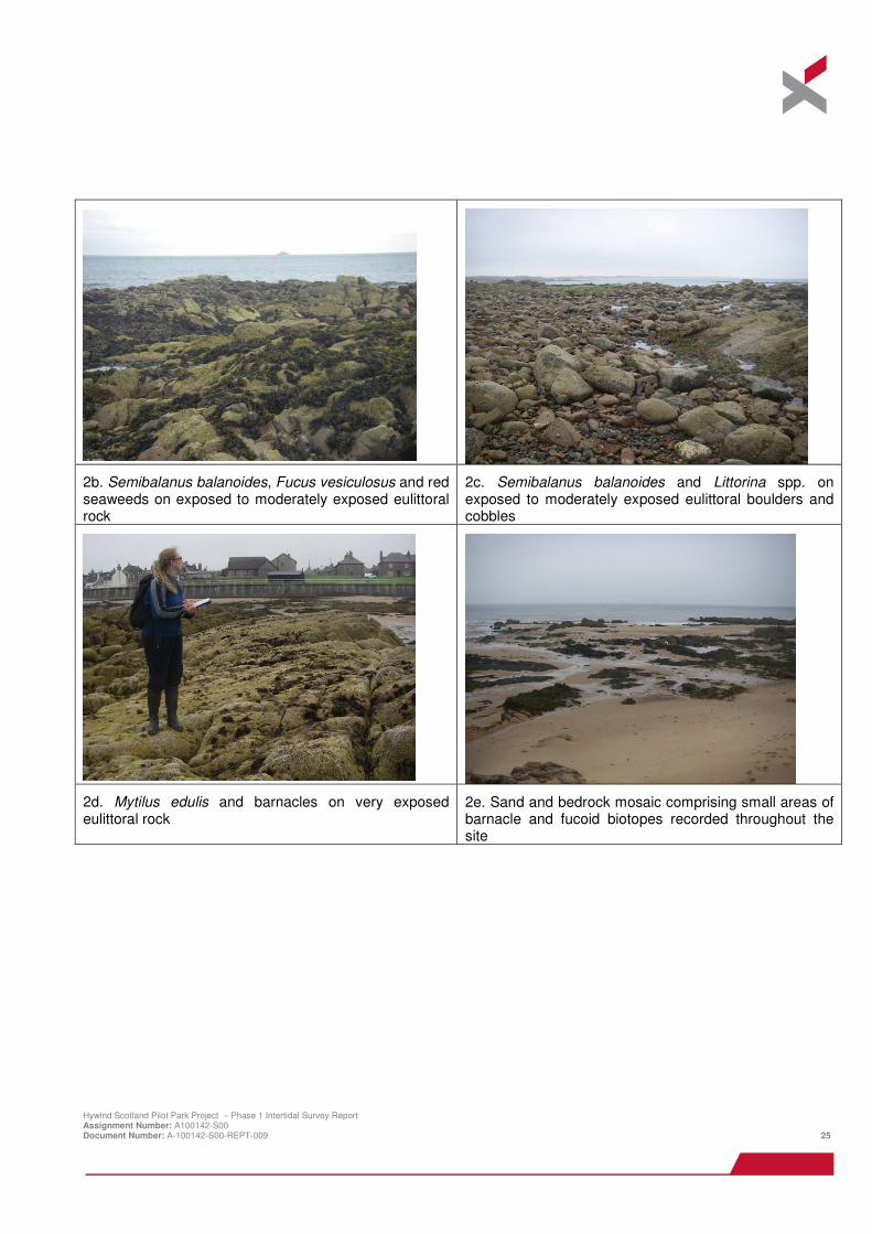
1d. Ephemeral green and red seaweeds on variable salinity and/or disturbed eulittoral mixed substrata
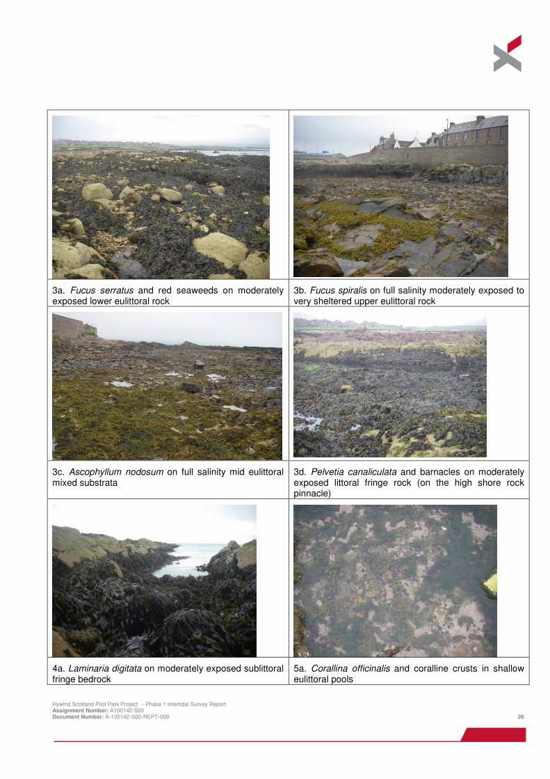
1e. Ephemeral green or red seaweeds (freshwater of sand-influenced)
Hywind Scotland Pilot Park Project – Phase 1 Intertidal Survey Report Assignment Number: A100142-S00 Document Number: A-100142-S00-REPT-009 24
1f. Porphyra purpurea and Enteromorpha spp. on sand –scoured mid or lower eulittoral rock
1g. Barren littoral shingle
1h. Littoral sediments 2a. Semibalanus balanoides, Patella vulgata and Littorina spp. on exposed to moderately exposed or vertical sheltered eulittoral rock
Hywind Scotland Pilot Park Project – Phase 1 Intertidal Survey Report Assignment Number: A100142-S00 Document Number: A-100142-S00-REPT-009 25
2b. Semibalanus balanoides, Fucus vesiculosus and red seaweeds on exposed to moderately exposed eulittoral rock
2c. Semibalanus balanoides and Littorina spp. on exposed to moderately exposed eulittoral boulders and cobbles
2d. Mytilus edulis and barnacles on very exposed eulittoral rock
2e. Sand and bedrock mosaic comprising small areas of barnacle and fucoid biotopes recorded throughout the site
Hywind Scotland Pilot Park Project – Phase 1 Intertidal Survey Report Assignment Number: A100142-S00 Document Number: A-100142-S00-REPT-009 26
3a. Fucus serratus and red seaweeds on moderately exposed lower eulittoral rock
3b. Fucus spiralis on full salinity moderately exposed to very sheltered upper eulittoral rock
3c. Ascophyllum nodosum on full salinity mid eulittoral mixed substrata
3d. Pelvetia canaliculata and barnacles on moderately exposed littoral fringe rock (on the high shore rock pinnacle)
4a. Laminaria digitata on moderately exposed sublittoral fringe bedrock
5a. Corallina officinalis and coralline crusts in shallow eulittoral pools
Hywind Scotland Pilot Park Project – Phase 1 Intertidal Survey Report Assignment Number: A100142-S00 Document Number: A-100142-S00-REPT-009 27
Subsidiary biotope: Verrucaria maura and sparse barnacles on exposed littoral fringe rock
Subsidiary biotope: Himanthalia elongata and red seaweeds on exposed to moderately exposed lower eulittoral rock
Subsidiary biotope: Rhodothamniella floridula on sand scoured lower eulittoral rock
2c
WhiteStane
Outfall
TheIsland
Horseback
The Gadle
The Ive
Cargeddie
Red Stane
2b
4a
4a
4a
2c
2b
3b
2e4a
1c
2c
3a
1e
5a
3a
1f
1h
2b
3b
4a
2a
1a
3a & 2c mosaic
2c
1b
1g
3b
2a
1h
1g
3b
3a
3a
2a
2a
5a
2b & 2c mosaic
1h
4a2a
3b
3d
3c
2c & 3a mosaic
3b
2a
1d1c
2a
1g
1h
3a
2a & 2c mosaic
2a
2a & 2d mosaic
3d
1b
1h
1b3b
2a
3c
2a and 3a mosaic
1c
2b
2a
3a
1b
2a
1b
1c
1c
2a 1c
1b
3d
412500 413000 413500 414000
8465
0084
7000
8475
00
DRAWN: JH CHECKED: SE APPROVED: LFPROJECT: A100142
0 100 200 m±
SCALE:
0 0.1 nm
KEY:
Intertidal Survey ExtentLifeform
Lichens and algaeShingle, coarse sand andmixed sedimentMussels and BarnaclesFucoidsKelpAlgal turfSandBarren sea defences
CLIENT:
TITLE: Figure A.1Intertidal biotopes recordedin the survey area
Lichens and algae1b. LR.FLR.Lic.Ver1c. LR.FLR.LicShingle, coarse sand and mixed sediment1g. LS.LCS.Sh.BarSh2e. Sand and bedrock mosaic comprising small areas of barnacle and fucoid biotopes recorded throughout the siteSand1h. LSMussels and Barnacles2a. LR.HLR.MusB.Sem.Sem2b. LR.HLR.MusB.Sem.FvesR2c. LR.HLR.MusB.Sem.LitX2d. LR.HLR.MusB.MytBFucoids3a. LR.MLR.BF.Fser.R3b. LR.LLR.F.FSpi.FS3c. LR.LLR.F.Asc.X3d. LR.MLR.BF.Pel.BKelp4a. IR.MIR.KR.Ldig.LdigAlgal turf1d. LR.FLR.Eph.EphX1e. LR.FLR.Eph1f. LR.FLR.Eph.EntPor5a. LR.FLR.Rkp.Cor.Cor