1 Deceased; formerly President of the Subcommission for Metallogenic Maps of the Commission for the Geological Map of the World (CGMW). 2 Council for Geoscience, Private Bag x112, Pretoria 0001, South Africa. Status of Metallogenic Mapping in the World Today— With Special Reference to the Digital Metallogenic Map of Africa By Erik Hammerbeck 1 and Milica Veselinovic-Williams 2 Metallogenic Maps—Culmination of Data Synthesis Invariably, metallogenic maps are complex, portraying a multitude of data on current knowledge about geologi- cal processes that may have contributed to the formation of mineral deposits. As such, they represent a most valuable store of information about the mineral potential of countries, regions, or continents. In this point lie both their strength and their Achilles’ heel. One might expect that metallogenic maps would be regarded as being indispensable tools for mineral exploration, land use planning, teaching, and research in eco- nomic geology, but often that does not seem to be the case. One reason is that metallogenic maps are generally far too complex to be useful for non-geoscientist planners and decisionmakers. Another is that comprehensive maps can be compiled only for regions where the geology is well understood and which are reasonably well explored, often at a time long after exploration activities have passed. So, if metallogenic maps indeed come too late, so to speak, to be indispensable tools for mineral exploration, or remain grossly undervalued in land use planning and even by the geological community at large, what is their worth? The obvious answer lies in regional or global mineral resource assessments. Without the systematic collation and synthesis of mineral-resource data embodied in metallogenic maps, it is not possible to arrive at a meaningful overview of the mineral potential of a country or region. As a result, a large number of metallogenic and related mineral maps have been published over the past three or four decades on national, regional, or continental scales. To provide a review of the worldwide availability of such maps is beyond the scope of this paper. Whereas large- and medium-scale metallogenic maps (up to 1:250,000) continue to serve a useful purpose to synthesize and document details of selected mineralized ter- ranes, maps at scales of 1:1,000,000 and smaller lend them- selves best to metallogenic analysis. Mineral exploration is an iterative process and, as making new discoveries becomes ever more difficult, success depends very much on acquiring and applying new knowledge in innovative ways. For this reason, it must be stressed that it is in the interest of countries, regions, or continents with emerg- Historical Background Although the study of mineral deposits has preoc- cupied geologists since the very beginnings of the earth sciences, the concept of metallogeny is less than 100 years old; the term was coined by Louis Auguste de Launay in 1913 (quoted by Lindgren, 1933). The debate on what the concept of metallogeny means by definition and in terms of contemporary geological theory, how it should be depicted on maps, and how it can be used as an exploration tool has largely subsided (Lindgren, 1933; Turneaure, 1955; Petra- scheck, 1965; Guild, 1971, 1972, 1974; Routhier, 1983; Guilbert and Park, 1986). Today there is some convergence toward two dominant schools of thought regarding metal- logenic maps, the French and northern American. There are, however, equally as many exceptions or adaptations to these two approaches, as for example in the recent maps produced in the United Kingdom, Australia, and Canada. A third type of metallogenic map, exemplified by Russian maps of the Soviet era, has found less acceptance in view of the complexity of their legends, although some examples of this type have been published only very recently for Angola and Mozambique. Consensus on the matter of how best to present metallogenic information is unlikely ever to be reached, although it would help the cause of global resource assessment tremendously. We advocate the French legend for its simplicity (the symbols are easy to relate to), its descriptiveness (being largely factual rather than interpretive), and the cartographic clarity of representation. One of the best examples is the “International Mineral Deposits Map of Africa,” of which only sheet 1 was published (Emberger, 1991). Emberger’s map legend, which was used as the basis for the “Interna- tional Digital Metallogenic Map of Africa” (Veselinovic- Williams and others, 1999), can be converted into geographic information system (GIS) format with only minimal adapta- tions, and it was found to lend itself perfectly to metallogenic modeling.
Transcript
1Deceased; formerly President of the Subcommission for Metallogenic Maps of the Commission for the Geological Map of the World (CGMW).
2Council for Geoscience, Private Bag x112, Pretoria 0001, South Africa.
Status of Metallogenic Mapping in the World Today— With Special Reference to the Digital Metallogenic Map of Africa
By Erik Hammerbeck1 and Milica Veselinovic-Williams2
Metallogenic Maps—Culmination of Data Synthesis
Invariably, metallogenic maps are complex, portraying a multitude of data on current knowledge about geologi-cal processes that may have contributed to the formation of mineral deposits. As such, they represent a most valuable store of information about the mineral potential of countries, regions, or continents. In this point lie both their strength and their Achilles’ heel. One might expect that metallogenic maps would be regarded as being indispensable tools for mineral exploration, land use planning, teaching, and research in eco-nomic geology, but often that does not seem to be the case.
One reason is that metallogenic maps are generally far too complex to be useful for non-geoscientist planners and decisionmakers. Another is that comprehensive maps can be compiled only for regions where the geology is well understood and which are reasonably well explored, often at a time long after exploration activities have passed. So, if metallogenic maps indeed come too late, so to speak, to be indispensable tools for mineral exploration, or remain grossly undervalued in land use planning and even by the geological community at large, what is their worth?
The obvious answer lies in regional or global mineral resource assessments. Without the systematic collation and synthesis of mineral-resource data embodied in metallogenic maps, it is not possible to arrive at a meaningful overview of the mineral potential of a country or region. As a result, a large number of metallogenic and related mineral maps have been published over the past three or four decades on national, regional, or continental scales. To provide a review of the worldwide availability of such maps is beyond the scope of this paper. Whereas large- and medium-scale metallogenic maps (up to 1:250,000) continue to serve a useful purpose to synthesize and document details of selected mineralized ter-ranes, maps at scales of 1:1,000,000 and smaller lend them-selves best to metallogenic analysis.
Mineral exploration is an iterative process and, as making new discoveries becomes ever more difficult, success depends very much on acquiring and applying new knowledge in innovative ways. For this reason, it must be stressed that it is in the interest of countries, regions, or continents with emerg-
Historical BackgroundAlthough the study of mineral deposits has preoc-
cupied geologists since the very beginnings of the earth sciences, the concept of metallogeny is less than 100 years old; the term was coined by Louis Auguste de Launay in 1913 (quoted by Lindgren, 1933). The debate on what the concept of metallogeny means by definition and in terms of contemporary geological theory, how it should be depicted on maps, and how it can be used as an exploration tool has largely subsided (Lindgren, 1933; Turneaure, 1955; Petra-scheck, 1965; Guild, 1971, 1972, 1974; Routhier, 1983; Guilbert and Park, 1986). Today there is some convergence toward two dominant schools of thought regarding metal-logenic maps, the French and northern American. There are, however, equally as many exceptions or adaptations to these two approaches, as for example in the recent maps produced in the United Kingdom, Australia, and Canada. A third type of metallogenic map, exemplified by Russian maps of the Soviet era, has found less acceptance in view of the complexity of their legends, although some examples of this type have been published only very recently for Angola and Mozambique. Consensus on the matter of how best to present metallogenic information is unlikely ever to be reached, although it would help the cause of global resource assessment tremendously.
We advocate the French legend for its simplicity (the symbols are easy to relate to), its descriptiveness (being largely factual rather than interpretive), and the cartographic clarity of representation. One of the best examples is the “International Mineral Deposits Map of Africa,” of which only sheet 1 was published (Emberger, 1991). Emberger’s map legend, which was used as the basis for the “Interna-tional Digital Metallogenic Map of Africa” (Veselinovic- Williams and others, 1999), can be converted into geographic information system (GIS) format with only minimal adapta-tions, and it was found to lend itself perfectly to metallogenic modeling.
11� Proceedings, Workshop on Deposit Modeling, Mineral Resource Assessment, and Sustainable Development
ing mining industries to produce metallogenic maps that are topical and timely to attract mining investment, which remains one of the pillars of economic development.
On a global scale, the Commission for the Geological Map of the World (CGMW), and more precisely its Subcommission for Metallogenic Maps, endeavors to promote this cause through international collaborative projects. Presently, projects carried out under its auspices include the international metallogenic maps of Africa and of South America, both at 1:5 million scale, and it is a goal to add a map of the Middle East to this series. In addition, a new thematic global map of exceptionally large mineral deposits is being compiled at a scale of 1:25 million, primarily by a joint Chinese-Russian research project. A large database on the deposits included on this map is being compiled at the Vernadtsky State Geological Museum in Moscow. The effort to understand exceptionally large mineral deposits may benefit from current Russian research on the role of deep crustal structures (Konstantinov and others, 1999).
Metallogeny in the Information AgeThe electronic media have changed the nature of metal-
logenic maps during the last decade or so. Since the early 1980s, many geological surveys have started to develop min-eral deposit databases, and today GIS and digital mapmaking are commonplace. More important, however, is the ability to exchange data and to integrate the information, more or less at will, with other datasets. In addition, GIS technology brings the power to query and manipulate data and to produce any number of customized products for a multitude of research and consumer needs. Much of the power of present-day metallog-eny, therefore, lies in access to digital data sources that enable users for the first time ever to create their own innovative derivative products.
Restrictions on access to data and information and copyright issues, however, often inhibit this process. Clear distinctions must be drawn here between legal copyright issues and self-imposed restrictions to protect partisan interests. According to Gueiros (2000), the availability of intellectually protected documents on the World Wide Web is causing a legal revolution, in that new rules must be developed on how to regulate intellectual property in cyberspace.
In an attempt to promote the free exchange of data and information, it may help to clearly define the issues at stake and to recognize that—
Copyright can apply only to intellectual property. In other words, copyright applies only to definitive information products that express specific interpretations or view-points at the time when that product was generated. At present, copyright is governed by the Berne Convention on authors’ rights (United Nations, World Intellectual Property Organization, 1979) and the copyright legislation of various countries.
•
Copyright is vested in the source of that information prod-uct; for example, the institution or author of the product or in the client in terms of a commercial agreement.
Data are neither a product in their own right, nor can data be regarded as intellectual property.
Data and information are tradeable commodities, but they are not free when classified as confidential and thus specifically protected and restricted.
The “International Digital Metallogenic Map of Africa” (Veselinovic-Williams and others, 1999) is a case in point. Comprehensive electronic data have been compiled from published nonproprietary hardcopy information, from data received directly or indirectly from every geologi-cal survey of Africa participating in this project, and from other data sources. While the CD-ROM containing these data is being sold at a nominal cost to defray expenses, it is copyright protected, meaning the data may not be resold. The users who have acquired the data, however, are per-mitted to utilize it to their best advantage, to merge it with other data sources, or to create any number of new infor-mation products. It is anticipated that, in the near future, a fully compatible global database can be compiled using the new standard established for metallogenic mapping and with the added ability to seamlessly integrate the African data with data for South America and, eventually, with data for the Middle East.
The Metallogenic Map of Africa as a Deposit Modeling Tool
The “International Digital Metallogenic Map of Africa” (Veselinovic-Williams and others, 1999), and particularly the Metallogenic Map of Africa (MMA) database that was cre-ated, is ideally suited to describe the essential attributes of all mineral deposits of Africa. This use not only greatly facilitates the description of definitive ore deposit types but also helps scientists to understand their genetic association and their comparison in space and time.
The MMA is based on an advanced GIS data model, comprising various data layers (coverages) carrying the perti-nent data on which the parameters for descriptive and genetic deposit models can be defined, as summarized in tables 1 and 2. It is a modern, relational database developed in Corel Para-dox and is fully compatible with Oracle, ArcInfo, ArcView, and similar application software.
Although genetic deposit model type data are not carried in the database because of their subjective nature, such models can be easily derived from the available data by association, combination, and interpolation of the various data elements and parameters. Metallogenic analysis is facilitated by pre-defined parameters, as shown in table 3.
•
•
•
Table 1. The database model of the Metallogenic Map of Africa database.[The Metallogenic Map of Africa (MMA) database was created during compilation of the “International Digital Metallogenic Map of Africa” (Veselinovic-Williams and others, 1999)]
Coverages Attribute tables Standard tables Cartographic tablesGMS Lithology, chronostratigraphy Numerous lookup tables to standardize
and validate data entries.Numerous tables defining the symbology, hatchings,
colors, and text to be used for map outputs.GME Geotectonic environmentGMO OrogenyGSL Geological structuresMDP Mineral deposits
Table 2. The Metallogenic Map of Africa database structure, with some examples.[The Metallogenic Map of Africa (MMA) database was created during compilation of the “International Digital Metallogenic Map of Africa” (Veselinovic-Williams and others, 1999)]
Geological data (with examples) Mineral deposit dataCoverage and specific item Lookup table Code Latitude/longitudeGMSPolygon key 12S (Gweru) Greenstone belt Deposit numberChronostratigraphy GMS MARC State or countryLithology LIT BASLT Commodities present (1, 2, 3)Lithology qualifier LILA GBELT Deposit size (according to size classification)GME Deposit namePolygon key 2E Deposit status (active, dormant, occurrence)Environment GME OROG Deposit shape and orientationGMO Host-rock lithologyPolygon key 3AO Host-rock lithostratigraphic name and ageMain orogeny GMO MGND Ore genesisMain orogeny age GMO 2 to 1.8 Ga Ore mineralogy2d orogeny SCO ZMBZ Resources and production2d orogeny age SCO 1 to 0.5 Ga Comments
Table �. Selected parameters in the Metallogenic Map of Africa database to facilitate deposit modeling and metallogenic analysis.
[The Metallogenic Map of Africa (MMA) database was created during compilation of the “Interna-tional Digital Metallogenic Map of Africa” (Veselinovic-Williams and others, 1999)]
Geological data Physical and other data Genetic criteriaChronostratigraphic classification Commodities present (1, 2, 3) Magmatic:Host-rock lithology Shape (morphology) of deposit • IntrusiveHost-rock environment: Size classification • Extrusive • Continental Status (active, dormant, occurrence) Hydrothermal • Paralic Mineralogy of ore Sedimentary • Marine Mineralization age Diagenetic • Plutonic Pedogenic • Orogenic* Metamorphic
*Orogenic name and age.
Status of Metallogenic Mapping in the World Today 117
11� Proceedings, Workshop on Deposit Modeling, Mineral Resource Assessment, and Sustainable Development
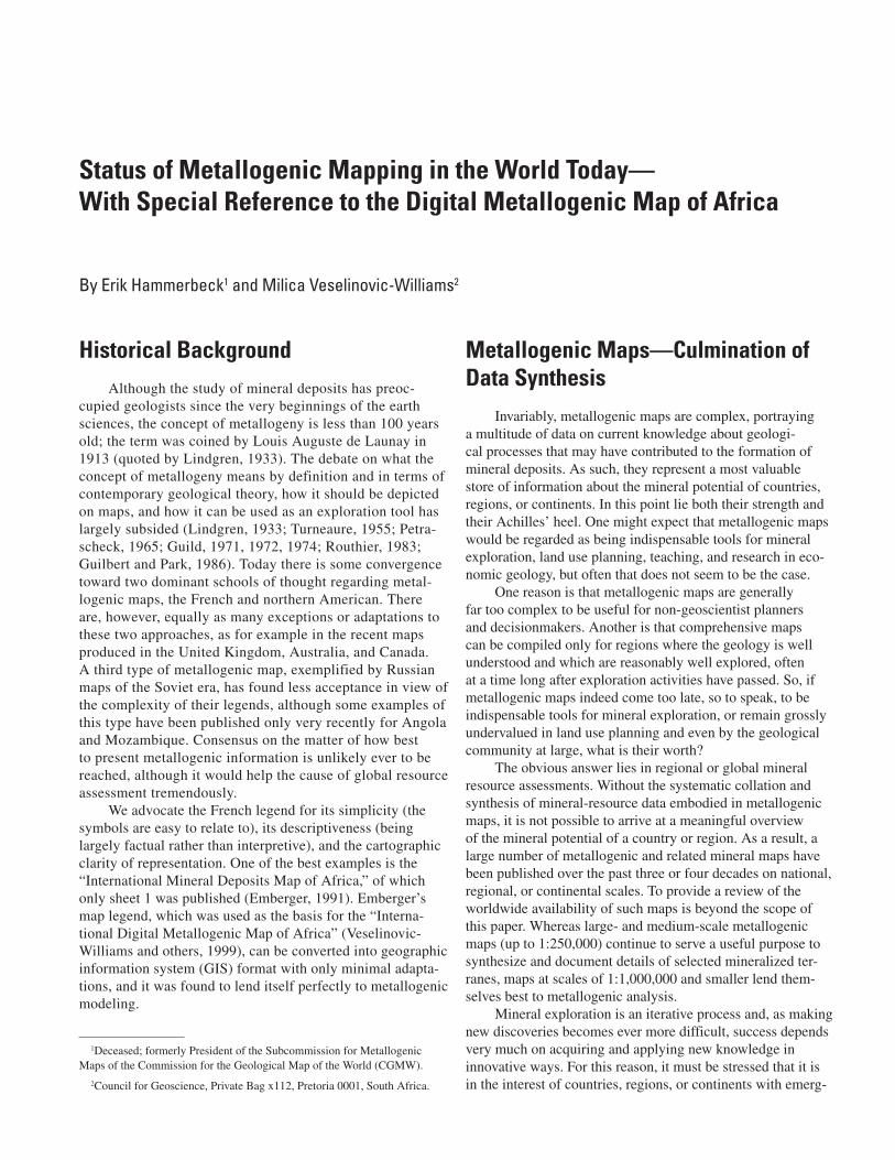
The African continent has had a complex geologic and orogenic history, too diverse for a detailed discussion in this paper. The interested reader is referred to the many benchmark books and papers, including those by Cahen and others (1984), Petters (1991), Milesi and others (1992), Windley (1995), and De Wit and Ashwal (1997). Here we attempt only to highlight some important metallogenic aspects, based on views generated from the MMA database, which presents countless modeling scenarios.
Archean
The Archean rocks in Africa (fig. 1) consist of various lithologic assemblages in greenstone belts and high-grade meta-morphic terranes. Greenstone belts consist of thick volcano-sedimentary sequences that have mostly experienced low-grade metamorphism but that have reached granulite facies locally (De Wit and Ashwal, 1997). The belts represent supracrustal cover to the granitic basement rocks, which originated in three Archean magmatic stages: (1) 3.5–3.2 Ga, tonalite/trondhjemite gneisses, (2) 3.2–2.7 Ga, porphyritic migmatite/gneiss, and (3) 2.8–2.5 Ga, syn- to post-orogenic granites.
Of particular metallogenic interest are the Archean green-stone terranes of the Kaapvaal, Zimbabwe, Kivu-Democratic Republic of the Congo (DRC)-West Nile, Tanzania, Ntem-Chaillu, Leo-Man, and Reguibat metallogenic provinces (fig. 1), as described in various papers in De Wit and Ashwal (1997). Mineral deposits associated with greenstone belts include gold, antimony, iron, chromium, nickel-copper, and copper-zinc. Fig-ure 2 shows the classic Zimbabwe craton, in which various ages of greenstone formation have been identified, each with its own metallogenic characteristics. The lowermost ultramafic units of some of these greenstone belts contain significant deposits of chromite, nickel-copper, and chrysotile asbestos (for example, Selukwe, Empress, and Shangani deposits).
Gold is widely distributed in all the Archean greenstone belts of the continent (Foster and Piper, 1993). Historically, the most productive and best developed gold deposits have been those in the Kaapvaal and Zimbabwe cratons. However, at present, the focus is on Tanzania, where numerous new gold deposits have recently been discovered (De Klerk, 2001). Fur-ther gold discoveries can be expected in other terranes having lesser known, but locally important, Archean gold deposits once these areas become more accessible to exploration. The Ituri belt of the DRC (de Kun, 1963), including Kilo-Moto, and the Gabon craton are examples of such potentially very important terranes. In general, gold is concentrated in struc-
Figure 1. Map showing Archean cratonic terranes (purple areas) of Africa: 1, Reguibat; 2, Leo-Man; 3, West Nile; 4, Kivu-Democratic Republic of the Congo (DRC); 5, Ntem-Chaillu; 6, Tanzania; 7, Kasai; 8, Zimbabwe; 9, Kaapvaal; 10, Antongilian. Map was derived from the Metallogenic Map of Africa (MMA) database, which was created during compilation of the “International Digital Metallogenic Map of Africa” (Veselinovic-Williams and others, 1999).
1
2
5 4
3
7
6
810
9
turally controlled vein deposits that cut basic to intermediate igneous rocks in the marginal and stratigraphically upper parts of the greenstone belts.
Algoma-type iron formations, associated with the volcanic successions of many greenstone belts, are chemical sediments formed by subaqueous volcanogenic exhalations. Locally, the iron formations constitute economic deposits of iron; for example, Buchwa in Zimbabwe and Nimba in Liberia.
Cratonized lithospheric plates developed during the late Archean in South Africa. This development led to the wide-spread formation of sedimentary basins, platform sediments, and continental-margin troughs and foreland basins at a time when greenstone belts were still forming farther north in Africa and elsewhere (in the time span 3.0–2.6 Ga). Examples on the Kaapvaal craton include the Dominion Group (3.075 Ga) and the Pongola (~2.9 Ga), Witwatersrand (~2.9–2.8 Ga), and Ventersdorp (2.62 Ga) Supergroups. Primary syndeposi-tional placer-type gold-uranium mineralization was deposited in the intracratonic Witwatersrand basin, South Africa, and is unique in that it was coeval with a worldwide event of basic to ultrabasic submarine volcanism associated with Late Archean greenstone belts. Three postdepositional events are recognized during which the ores were reconstituted and enriched. These are dated at 2,550 Ma, 2,300 Ma, and 2,000 Ma (Robb and Robb, 1998).
Important mineral deposits associated with pegmatites occur in the granitic terranes of the Zimbabwe craton (for example, Bikita) and the Kaapvaal craton (for example, the Mopane and Mica fields). These include deposits of tin, tung-sten, tantalum, niobium, lithium, mica, and beryllium.
Paleoproterozoic
During the Paleoproterozoic (2.5–1.6 Ga), many events affected metallogenesis; the following events are the most note-worthy in terms of their metallogenic significance (Olson, 2000):
Repeated platform sedimentation and volcanism, notably the Francevillian of Gabon, the Luizien of the DRC, and the Transvaal, Magondi, and Kheis of southern Africa.
Anorogenic magmatism, associated with formation of fea-tures such as the Great Dyke, the Bushveld Complex, and the Kunene Complex, all of which resulted from tensional conditions subsequent to the stabilization of the cratons or from a combination of tectonothermal events linked to accretionary processes.
The development of accretionary and collisional orogens of the Ubendian/Rusizian (central and southern Africa) and the Birimian of West Africa.
Evolutionary changes in the Earth’s atmosphere, hydro-sphere, and biosphere during this time had a major influence on processes leading to metal accumulation. Intracratonic basins that formed during this time host important stratabound iron, man-ganese, asbestos, and copper mineralization. Enriched Superior-type iron formations occur in South Africa (for example, Sishen and Thabazimbi), Angola (Cassinga), Mozambique (Honde), and Gabon (Belinga). The deposits of Moanda (Gabon) and the Kalahari (South Africa) constitute the world’s largest resources of manganese. One of the first appearances of stratabound sedi-mentary copper mineralization occurs at several stratigraphic levels within the thick sequence of early Proterozoic rocks of the
•
•
•
Figure 2. Map showing the Zimbabwe craton (colored areas), the main elements of which include the Sebak-wean Group (S) (3.6 Ga), the Bulawayan Supergroup (B) (2.8–2.7 Ga), various associated syntectonic and posttectonic gneisses and granites (G), and the Limpopo belt (L). Map was derived from the Metallogenic Map of Africa (MMA) data-base, which was created dur-ing compilation of the “Interna-tional Digital Metallogenic Map of Africa” (Veselinovic- Williams and others, 1999).
AAgAu
BeCrCuFFe
GrHgKy
LiMnMoNbNi
PbZn
SbSn
WT
B
B
G
B
G
G
G
S
L
Status of Metallogenic Mapping in the World Today 119
120 Proceedings, Workshop on Deposit Modeling, Mineral Resource Assessment, and Sustainable Development
Piriwiri-Lomagundi basin, northwestern Zimbabwe (for example, Mangula, Shackleton, Alaska, and Shamrocke).
Of great metallogenic importance are the anorogenic basic to ultrabasic intrusions, including the Great Dyke (Zim-babwe), which formed at ~2.5 Ga, and the Bushveld Complex (South Africa), now tightly constrained at 2.05 Ga, as well as the Molopo (Botswana), Atchiza (Mozambique), and Kunene (Namibia-Angola) complexes. The Great Dyke and the Bush-veld Complex, in particular, host very large economic deposits of chrome, platinum-group elements, iron, titanium, vanadium, and nickel-copper mineralization. The copper-rich Phalaborwa carbonatite (2.05 Ga) and the much younger Premier diamond-iferous kimberlite pipe (1.15 Ga) are both manifestations of extensional tectonic regimes prevalent within the thick, stable Kaapvaal craton since the late Archean. The greater Kaapvaal craton (including its younger accreted additions) seems to have been exceptionally well suited for the subsequent devel-opment of diamondiferous kimberlites, and it has a significant region of diamond formation in its structural root.
The Birimian belt of West Africa formed at 2.2–2.0 Ga and represents a series of juvenile, accreted terranes (Milesi and others, 1992). These terranes consist of supracrustal belts very similar to Archean greenstone belts and contain basaltic pillow lava flows, andesitic to dacitic pyroclastic rocks and lava flows, volcanogenic turbidites, and manganiferous cherts, as well as flysch-type turbidites. All these rocks were meta-morphosed to greenschist facies and intruded by peraluminous granitic plutons. A great variety of mineral deposits occurs in the Birimian greenstone belts, especially gold, manganese,
iron, and small but economic lead, copper, antimony, sil-ver, nickel, cobalt, tin, and tungsten deposits. The following genetic types of gold mineralization have been recognized: mesothermal load (Ashanti, Prestea, Marlu, all in Ghana), tourmalinized turbidite sandstone (Loulo, Mali), quartz veins with native gold (Poura, Bouroum, Guiro, all in Burkina Faso), shear-zone-hosted disseminated (Bogosu, Konogo, Ghana), intrusive disseminated (Ayenfuri, Ghana), porphyry copper-gold (Diénémera, Burkina Faso), and paleoplacers (Tarkwa, Ghana).
Collisional mobile belts such as the Ubendian-Rusizian (1.8–2.0 Ga) and Toro of eastern Africa are generally poorly mineralized. An exception is the important stratiform syn-genetic copper-cobalt deposit at Kilembe in the Toro Super-group, Uganda. Hydrothermal deposits of lead (Mukwamba), copper (Lufusi), and gold (Lupa district) occur in Tanzania, related to late-orogenic Ubendian igneous activity.
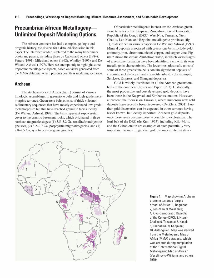
Mesoproterozoic
The Mesoproterozoic (1.6 Ga–950 Ma) was marked by one of the most distinctive orogenic events in Africa, which is known as the Kibaran orogeny (1,400–950 Ma); figure 3 shows the regional distribution of rocks formed during this orogeny (the Kibaran metallogenic province or belt), including the Irumide, Nampula, and Namaqua-Natal belts. Pohl (1994) and Olson (2000) linked the metallogeny of the Kibaran to a series of events related to rifting, sedimentation, magmatism, metamorphism, and tectonic deformation. The crosscutting
Figure �. Map showing the Mesoproterozoic Kibaran metallogenic province (orange areas) of central and southern Africa. Numbered belts: 1, Mayombe; 2, Burundian; 3, Karagwe-Ankolean; 4, Shaba; 5, Mporokoso; 6, Zambia (including the Irumide belt); 7, Malawi; 8, Nampula; 9, Madagascar; 10, Sinclair; 11, Namaqua-Natal. Map was derived from the Metallogenic Map of Africa (MMA) database, which was created during compilation of the “International Digital Metallogenic Map of Africa” (Veselinovic-Williams and others, 1999).
AC
Au
Be
Co
Cu
F
Fe
Gr
Mn
Nb
Ni
Pb
Zn
Sn
T
P
RE
Ti
U
V
Vm
W
12
3
4 5
67 8
9
10
11
nature of the Kibaran belt with the Ubendian-Rusizian belt and the fact that it is also flanked by Archean massifs to the east and west support the contention that the Kibaran belt devel-oped intracratonically. Mineralization within the different parts of the Kibaran belt differs markedly. The intracratonic Kibaran belt of central Africa, for example, defines a major tin (-tung-sten) province in the northern DRC, Burundi, and Rwanda. Tin and tungsten tend to occur in quartz veins associated with late-orogenic granitic intrusions. Beryllium, columbo-tantalite, and lithium ores occur in pegmatite zones close to, but separated from, the hydrothermal tin-tungsten mineralization.
The Kibaran-age Irumide belt defines a red-bed-type copper province in a rift-bounded succession of mainly clastic sedimentary rocks, extending discontinuously from Ghanzi in northwestern Botswana to Witvlei and Klein Aub in Namibia. Sedimentary-exhalative massive sulfide mineralization (cop-per, lead-zinc, silver) occurs in Namaqualand (Aggeneys, Broken Hill, Gamsberg). Volcanogenic exhalative base-metal deposits are found in a long north-south-trending belt adjacent to the western margin of the Kaapvaal craton. The now-defunct Prieska copper-zinc deposit, like the other deposits in the belt, is stratabound in a basic metavolcanic unit composed mainly of amphibolites and amphibole gneisses.
Neoproterozoic and Early Paleozoic
The Pan-African tectonothermal event affected much of Africa during the Neoproterozoic and early Paleozoic in the period from at least 950 Ma to about 450 Ma (fig. 4). The Pan-African belts developed through a complex sequence involving an initial rifting phase with related sedimentation and magma-tism, followed by ocean opening, subduction and plate collision, and postcollisional magmatism. The Katanga belt (Zambia and DRC) forms a broad curved zone of deformed sedimen-tary rocks, known as the Lufilian arc, which host major copper (-cobalt) deposits. These deposits are confined to specific shale or conglomerate horizons, which may represent a rift-bounded succession. Apart from copper and cobalt, other significant deposits in the Copperbelt contain uranium-gold (Shinkolobwe, DRC) and lead-zinc-copper-cadmium (Kipushi, DRC).
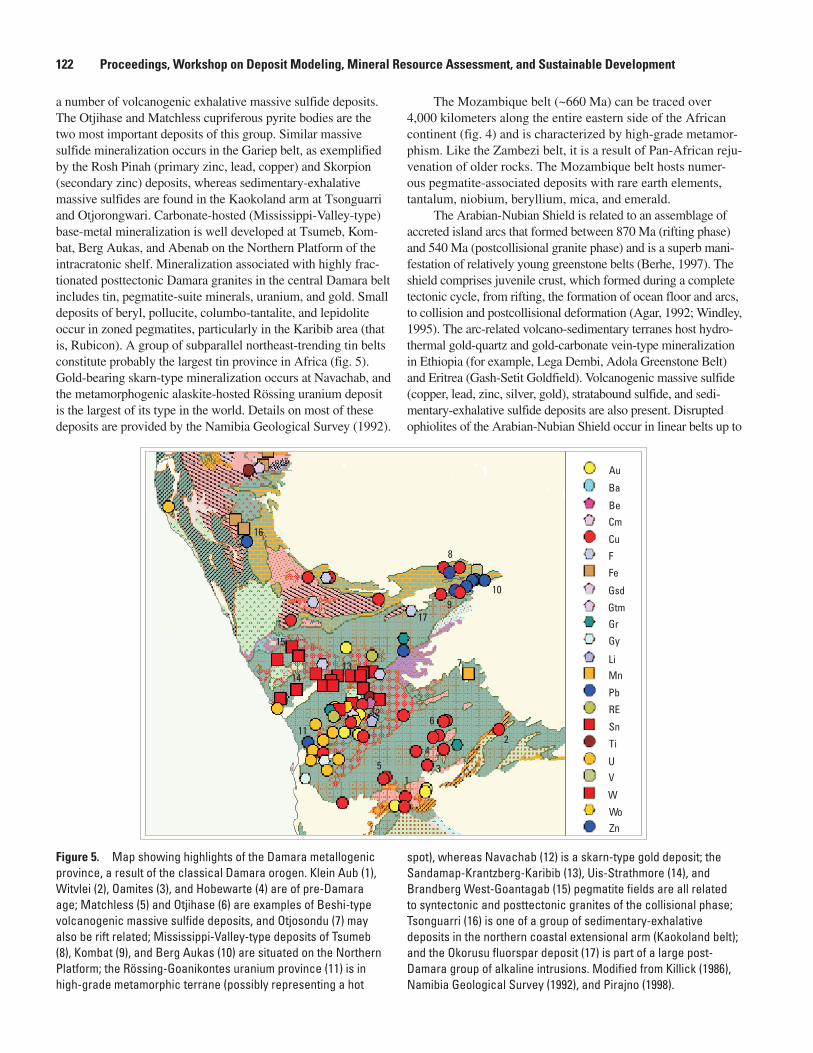
The Damara Supergroup (Miller, 1983; Pirajno, 1998) in Namibia is dated at 900–600 Ma and is one of the best devel-oped orogenic belts in Africa. It is composed of a northern arm (Kaokoland) and a southern arm (Gariep), both of which have undergone full Wilson cycles, and a northeast-trending intracra-tonic rift zone, all of which carry important mineralization (fig. 5). The Matchless amphibolite is closely associated with
Figure �. Map showing belts (areas tinted and striped in green) formed during the Neoproterozoic and early Paleozoic Pan-African orogeny: 1, Anti-Atlas; 2, Mauritanide; 3, Hoggar; 4, Tibesti; 5, Nubian Shield; 6, Benin-Nigerian; 7, Oubanguide; 8, West Nile; 9, West Congolian; 10, Katanga; 11, Mozambique; 12, Damara; 13, Gariep; 14, Saldania. Map was derived from the Metallogenic Map of Africa (MMA) database, which was created during compilation of the “International Digital Metallogenic Map of Africa” (Veselinovic-Williams and others, 1999).
1
2
3
4
5
6
7
8
9
10
11
12
13
14
Status of Metallogenic Mapping in the World Today 121
122 Proceedings, Workshop on Deposit Modeling, Mineral Resource Assessment, and Sustainable Development
a number of volcanogenic exhalative massive sulfide deposits. The Otjihase and Matchless cupriferous pyrite bodies are the two most important deposits of this group. Similar massive sulfide mineralization occurs in the Gariep belt, as exemplified by the Rosh Pinah (primary zinc, lead, copper) and Skorpion (secondary zinc) deposits, whereas sedimentary-exhalative massive sulfides are found in the Kaokoland arm at Tsonguarri and Otjorongwari. Carbonate-hosted (Mississippi-Valley-type) base-metal mineralization is well developed at Tsumeb, Kom-bat, Berg Aukas, and Abenab on the Northern Platform of the intracratonic shelf. Mineralization associated with highly frac-tionated posttectonic Damara granites in the central Damara belt includes tin, pegmatite-suite minerals, uranium, and gold. Small deposits of beryl, pollucite, columbo-tantalite, and lepidolite occur in zoned pegmatites, particularly in the Karibib area (that is, Rubicon). A group of subparallel northeast-trending tin belts constitute probably the largest tin province in Africa (fig. 5). Gold-bearing skarn-type mineralization occurs at Navachab, and the metamorphogenic alaskite-hosted Rössing uranium deposit is the largest of its type in the world. Details on most of these deposits are provided by the Namibia Geological Survey (1992).
The Mozambique belt (~660 Ma) can be traced over 4,000 kilometers along the entire eastern side of the African continent (fig. 4) and is characterized by high-grade metamor-phism. Like the Zambezi belt, it is a result of Pan-African reju-venation of older rocks. The Mozambique belt hosts numer-ous pegmatite-associated deposits with rare earth elements, tantalum, niobium, beryllium, mica, and emerald.
The Arabian-Nubian Shield is related to an assemblage of accreted island arcs that formed between 870 Ma (rifting phase) and 540 Ma (postcollisional granite phase) and is a superb mani-festation of relatively young greenstone belts (Berhe, 1997). The shield comprises juvenile crust, which formed during a complete tectonic cycle, from rifting, the formation of ocean floor and arcs, to collision and postcollisional deformation (Agar, 1992; Windley, 1995). The arc-related volcano-sedimentary terranes host hydro-thermal gold-quartz and gold-carbonate vein-type mineralization in Ethiopia (for example, Lega Dembi, Adola Greenstone Belt) and Eritrea (Gash-Setit Goldfield). Volcanogenic massive sulfide (copper, lead, zinc, silver, gold), stratabound sulfide, and sedi-mentary-exhalative sulfide deposits are also present. Disrupted ophiolites of the Arabian-Nubian Shield occur in linear belts up to
Au
Ba
BeCm
Cu
F
Fe
Gsd
GtmGr
Gy
LiMn
Pb
RE
Sn
Ti
UV
W
WoZn
15 3
24
6
7
8
910
11
12
1314
15
16
17
Figure �. Map showing highlights of the Damara metallogenic province, a result of the classical Damara orogen. Klein Aub (1), Witvlei (2), Oamites (3), and Hobewarte (4) are of pre-Damara age; Matchless (5) and Otjihase (6) are examples of Beshi-type volcanogenic massive sulfide deposits, and Otjosondu (7) may also be rift related; Mississippi-Valley-type deposits of Tsumeb (8), Kombat (9), and Berg Aukas (10) are situated on the Northern Platform; the Rössing-Goanikontes uranium province (11) is in high-grade metamorphic terrane (possibly representing a hot
spot), whereas Navachab (12) is a skarn-type gold deposit; the Sandamap-Krantzberg-Karibib (13), Uis-Strathmore (14), and Brandberg West-Goantagab (15) pegmatite fields are all related to syntectonic and posttectonic granites of the collisional phase; Tsonguarri (16) is one of a group of sedimentary-exhalative deposits in the northern coastal extensional arm (Kaokoland belt); and the Okorusu fluorspar deposit (17) is part of a large post-Damara group of alkaline intrusions. Modified from Killick (1986), Namibia Geological Survey (1992), and Pirajno (1998).
900 kilometers long and locally contain stratabound nickel-sulfide deposits. Chromium mineralization occurs as podiform ore bodies in ultramafic host rocks of Sudan. Tantalum-niobium mineraliza-tion is commonly found in late-tectonic alkali granites and (or) pegmatites, whereas tin-tungsten mineralization is related to late-tectonic greissenized and albitized alkali granites.
The Search for Undiscovered Resources
A perception exists in some investment circles that many parts of the world have been explored to the extent that the chance of making major new discoveries must be very small. This view, as far as geological risk factors are concerned, can be true only if one takes the present state of knowledge as a point of departure. The crux lies in continuously adding value to the knowledge base and significantly reducing the admit-tedly higher investment risk.
This need to keep adding to the knowledge base requires detailed geological mapping, high-density geophysical surveys, and geochemical mapping. Perhaps more important, however, is adding value to the knowledge base by producing state-of-the-art thematic maps, developing advanced data modeling and interpretation techniques and facilities, and generating innova-tive outputs to stimulate mineral exploration. The archiving of geological and mineral resource data and the availability of such data are crucial issues, not only for those countries that need to attract mining investment to stimulate their economic development, but indeed for the mining industry itself. Progres-sive thinking and bold decisions are required to exponentially increase the availability of data by unleashing the enormous potential locked up in proprietary data. Goldcorp’s Red Lake initiative in Canada (Viljoen, 2000) is a most inspiring example.
Africa is one of the last mining frontiers and is largely underresearched, poorly mapped, and underexplored. Conse-quently, the continent has a large potential for undiscovered resources; for instance, in the cratonic environments of central and western Africa. The availability of data, particularly in digital format, is critical in this regard, as it will facilitate unconstrained metallogenic analysis. It has been argued that the biggest value of digital data lies in the ability of a wide spectrum of users to utilize these data at will, to merge various sets of data, and to be innovative. The “International Digital Metallogenic Map of Africa” (Veselinovic-Williams and oth-ers, 1999) is an attempt to stimulate this process.
Of particular interest in this regard are potentially min-eralized terranes that are hidden under large tracts of cover, either of Quaternary sediments or of other younger formations. The Kalahari and the Karoo basins of southern and central Africa are salient examples. Attempts to unravel the basin structure and the underlying geology of the Kalahari (Haddon, 2000, 2001), for example, will undoubtedly facilitate renewed metallogenic analysis and exploration, which may lead to new discoveries. Advanced metallogenic synthesis and analysis of
environments that are conducive for large, hidden ore deposits remain a vital endeavor to locate undiscovered ore deposits. A current CGMW project to produce a map of exceptionally large deposits on a worldwide scale (1:25,000,000) is directed at this goal.
It is clear that a great deal of diligent work remains to be done to expand our knowledge by continued observation and documentation and particularly by adding value through the integration of relevant data sources, especially regional geophysical and geochemical data, and through the application of advanced data-modeling techniques. Metallogenic maps are indispensable in this regard but must continue to evolve to become useful predictive tools, lest they be rendered obsolete.
References Cited
Agar, R.A., 1992, The tectono-metallogenic evolution of the Arabian Shield: Precambrian Research, v. 58, p. 169–194.
Berhe, S.M., 1997, The Arabian–Nubian Shield, in De Wit, M.J., and Ashwal, L.D., eds., Greenstone belts: Oxford, Clarendon Press, p. 761–771.
Cahen, L., Snelling, N.J., Delhal, J., and Vail, J.R., 1984, The geochronology and evolution of Africa: Oxford, Clarendon Press, 512 p.
De Klerk, S.-L., comp., 2001, Gold deposits in the SADC [South African Development Community] region: South Africa Council for Geoscience, Mineral Resources Survey Programme, no. 4, 126 p., maps in pocket.
De Kun, Nicolas, 1963, The mineralogenetic provinces of Africa: Economic Geology, v. 58, no. 5, p. 774–790.
De Wit, M.J., and Ashwal, L.D., eds., 1997, Greenstone belts: Oxford, Clarendon Press, 809 p.
Emberger, André, 1991, Carte internationale des gîtes minéraux de l’Afrique [International mineral deposits map of Africa], 1:5,000,000, [sheet] 1, Rabat–Accra: Paris, Com-mission for the Geological Map of the World and UNESCO, scale 1:5,000,000.
Foster, R.P., and Piper, D.P., 1993, Archaean lode gold depos-its in Africa—Crustal setting, metallogenesis and cratoniza-tion: Ore Geology Reviews, v. 8, no. 3–4, p. 303–347.
Gueiros, N., Jr., 2000, Intellectual property of scientific papers: IGC News, 31st International Geological Congress, August 6–17, 2000, Rio de Janeiro, Brazil.
Guilbert, J.M., and Park, C.F., Jr., 1986, The geology of ore deposits: New York, Freeman, 985 p.
Guild, P.W., 1971, Metallogeny—A key to exploration: Mining Engineering, v. 23, no. 1, p. 69–72.
Status of Metallogenic Mapping in the World Today 12�
12� Proceedings, Workshop on Deposit Modeling, Mineral Resource Assessment, and Sustainable Development
Guild, P.W., 1972, Metallogeny and the new global tectonics: 24th International Geological Congress, Section 4, Mineral Deposits, p. 17–24.
Guild, P.W., 1974, Distribution of metallogenic provinces in relation to major earth features, in Petrascheck, W.E., ed., Metallogenetische und geochemische Provinzen, Metal-logenetic and geochemical provinces, [—Proceedings of a] symposium [organized with regard to the International Geo-logical Correlation Program], Leoben [Austria], Novem-ber 1972: Österreichische Akademie der Wissenschaften [Vienna], Erdwissenschaftliche Kommission, Schriftenreihe [Austrian Academy of Sciences, Earth Sciences Commis-sion, Publication Series], v. 1, p. 10–24. (Article in English with abstract in German.) (Published by Springer-Verlag, Vienna and New York.)
Haddon, I.G., comp., 2000, Isopach map of the Kalahari Group: Pretoria, South Africa Council for Geoscience, scale 1:2,500,000.
Haddon, I.G., comp., 2001, Sub-Kalahari geological map: Pretoria, South Africa Council for Geoscience, scale 1:2,500,000.
Killick, A.M., 1986, A review of the economic geology of northern South West Africa/Namibia, in Anhaeusser, C.R., and Maske, S., eds., Mineral deposits of southern Africa: Johannes-burg, Geological Society of South Africa, v. 2, p. 1709–1717.
Konstantinov, M.M., Cherkasov, S.V., Dankovtsev, R.F., and Egorkin, A.V., 1999, Specific crustal features for large and superlarge endogenic gold deposits (Siberia and Far East regions): Global Tectonics and Metallogeny, v. 7, no. 2, p. 143–147.
Lindgren, W., 1933, Mineral deposits (4th ed.; 3d impression revised): New York, McGraw-Hill, 930 p.
Milesi, J.-P., Ledru, Patrick, Feybesse, J.-L., Dommanget, Alain, and Marcoux, Eric, 1992, Early Proterozoic ore deposits and tectonics of the Birimian orogenic belt, West Africa: Precambrian Research, v. 58, p. 305–344.
Miller, R., McG., 1983, The Pan-African Damara orogen of South West Africa/Namibia, in Miller, R., McG., ed., The evolution of the Damara orogen of South West Africa/Namibia: Geological Society of South Africa Special Publi-cation 11, 515 p.
Namibia Geological Survey, 1992, Mineral resources of Namibia: [Windhoek] variously paged. (Also available on CD-ROM.)
Olson, S.F., 2000, The Proterozoic evolution of Africa: University of Witwatersrand, Economic Geology Research Unit, Information Circular 343, 61 p.
Petrascheck, W.E., 1965, Typical features of metallogenic provinces: Economic Geology, v. 60, no. 8, p. 1620–1634.
Petters, S.W., 1991, Regional geology of Africa: New York, Springer-Verlag, 717 p.
Pirajno, F., 1998, Geology and mineral deposits of Namibia, in Vearncombe, Susan, and Ho, S.E., eds., Africa—Geology and mineral exploration: Australian Institute of Geoscien-tists Bulletin 25, p. 61–66.
Pohl, W., 1994, Metallogeny of the northeastern Kibara belt, Central Africa—Recent perspectives: Ore Geology Reviews, v. 9, p. 105–130.
Robb, L.J., and Robb, V.M., 1998, Gold in the Witwa-tersrand basin, in Wilson, M.G.C., and Anhaeusser, C.R., eds., The mineral resources of South Africa (6th ed.): South Africa Council for Geoscience Handbook 16, p. 294–349.
Routhier, Pierre, 1983, Where are the metals for the future?—The metal provinces; An essay on global metallogeny (translation into English by Alexis Moiseyev and others): Orléans, France, Bureau de Recherches Géologiques et Minières, 399 p.
Turneaure, F.S., 1955, Metallogenic provinces and epochs, in Bateman, A.M., ed., Economic Geology, fiftieth anniver-sary volume, 1905–1955: Urbana, Ill., Economic Geology Publishing Company, pt. 1, p. 38–98.
United Nations, World Intellectual Property Organization, 1979, Berne Convention for the Protection of Literary and Artistic Works [as amended in 1979]: Geneva, available online at http://www.wipo.int/treaties/en/ip/berne/ trtdocs_wo001.html.
Veselinovic-Williams, Milica, Hammerbeck, E.C.I., and Wolmarans, L.G., comps., 1999, 1:5 000 000 interna-tional digital metallogenic map of Africa, sheets 5 & 6 (south of the Equator): Pretoria, South Africa Council for Geoscience and Commission for the Geological Map of the World, scale 1:5,000,000, one CD-ROM, introduc-tory leaflet. (A printed map was published in 2002 on 3 sheets.)
Viljoen, R.P., 2000, Effective use of geodata—The Goldcorp challenge: Geological Society of South Africa Geobulletin, v. 43, no. 4, p. 17–18.
Windley, B.F., 1995, The evolving continents (3d ed.): Chi-chester, U.K., John Wiley & Sons, 526 p.