Statutory Acknowledgements in Hawke’s Bay region 1 Statutory Acknowledgements These Statutory Acknowledgements do not form part of the Hawke’s Bay Regional Policy Statement or regional plans. The Statutory Acknowledgements are appended to plans as directed by legislation. PART 1 1 INTRODUCTION 1.1 Statutory acknowledgements have arisen from a number of Treaty of Waitangi Settlements around the country as part of cultural redress for Maori. 1.2 Statutory acknowledgements relate to specific areas of importance (known as statutory areas) to a claimant group 1 and affects processes under the Resource Management Act, including applications for resource consents and local authority responsibilities. 1.3 Part 2 of this document contains the statutory acknowledgements that wholly or in part cover statutory areas within Hawke’s Bay. 2 WHAT ARE STATUTORY ACKNOWLEDGEMENTS? 2.1 A statutory acknowledgement is a formal recognition made by the Crown of a claimant groups particular cultural, spiritual, historical and traditional association with a specific area (statutory area) owned by the Crown. 2.2 Statutory acknowledgements may apply to land, rivers, lakes, wetlands, landscape features or a particular part of the coastal marine area. Where the statutory acknowledgment relates to a river, lake, wetland or coastal area, the acknowledgement only applies to that part of the bed in Crown ownership. 3 WHAT IS THE PURPOSE OF STATUTORY ACKNOWLEDGEMENTS? 3.1 The purpose of statutory acknowledgements is to ensure: that a particular claimant group’s association with a certain significant area(s) in Hawke’s Bay is identified, and that the relevant claimant group is informed when a proposal may affect one of these areas. consent authorities have regard to statutory acknowledgements when identifying affected parties in relation to resource consent applications. 4 WHAT ARE HBRC’S OBLIGATIONS FROM STATUTORY ACKNOWLEDGEMENTS? 4.1 The main obligations arising for the Hawke's Bay Regional Council from statutory acknowledgements are summarised below: 4.2 Having regard to statutory acknowledgements 4.3 When assessing resource consent applications for an activity that is located within, adjacent to, or impacting directly on a statutory area, the consent authority must: have regard to 2 the statutory acknowledgement when forming an opinion as to whether relevant iwi is adversely affected by a resource consent application. 4.4 Decision making in relation to statutory acknowledgements is still subject to the provision of Part 2 of the RMA (i.e. the RMA’s purpose and principles). 4.5 Providing resource consent applications to relevant iwi 4.6 A consent authority must forward summaries of resource consent applications, to relevant iwi, where activities will affect the area to which the statutory acknowledgement applies. 4.7 The summary of the application must be provided as soon as reasonably practicable after the application has been received, and before the consent authority decides whether or not to notify the application. 4.8 Recording statutory acknowledgement in statutory plans 4.9 Information recording statutory acknowledgements must be attached to the Hawke’s Bay Regional Resource Management Plan and the Regional Coastal Environment Plan. 4.10 The attachment of information to plans is for information purposes only. The statutory acknowledgements in Part 2 of this document have not been formally adopted by the Regional Council, and does not form part of the Hawke’s Bay Regional Policy Statement or regional plans. 5 USE OF STATUTORY ACKNOWLEDGEMENTS IN SUBMISSIONS 5.1 Claimant groups will be able to cite statutory acknowledgements in submissions to a consent authority, as evidence of their particular association with statutory areas. In this context, the statutory acknowledgement does not of itself provide the association for the purpose of consent proceedings but may be taken into account by decision makers. 1 Claimant groups are usually iwi or large hapu (tribes and sub-tribes) that have a longstanding historical and cultural association with a particular area. Some very specific claims may result in agreements with smaller groups. 2 The phrase ‘have regard to’ does not guarantee that iwi will be considered an affected party in terms of the relevant sections of the RMA. Consent authorities retain discretion to make their own decision, after having regard to the statutory acknowledgement.
Transcript
Statutory Acknowledgements in Hawke’s Bay region 1
Statutory Acknowledgements These Statutory Acknowledgements do not form part of the Hawke’s Bay Regional Policy Statement or regional plans. The Statutory Acknowledgements are appended to plans as directed by legislation.
PART 1
1 INTRODUCTION
1.1 Statutory acknowledgements have arisen from a number of Treaty of Waitangi Settlements around the country as part of cultural redress for Maori.
1.2 Statutory acknowledgements relate to specific areas of importance (known as statutory areas) to a claimant group1 and affects processes under the Resource Management Act, including applications for resource consents and local authority responsibilities.
1.3 Part 2 of this document contains the statutory acknowledgements that wholly or in part cover statutory areas within Hawke’s Bay.
2 WHAT ARE STATUTORY ACKNOWLEDGEMENTS?
2.1 A statutory acknowledgement is a formal recognition made by the Crown of a claimant groups particular cultural, spiritual, historical and traditional association with a specific area (statutory area) owned by the Crown.
2.2 Statutory acknowledgements may apply to land, rivers, lakes, wetlands, landscape features or a particular part of the coastal marine area. Where the statutory acknowledgment relates to a river, lake, wetland or coastal area, the acknowledgement only applies to that part of the bed in Crown ownership.
3 WHAT IS THE PURPOSE OF STATUTORY ACKNOWLEDGEMENTS?
3.1 The purpose of statutory acknowledgements is to ensure:
that a particular claimant group’s association with a certain significant area(s) in Hawke’s Bay is identified, and that the relevant claimant group is informed when a proposal may affect one of these areas.
consent authorities have regard to statutory acknowledgements when identifying affected parties in relation to resource consent applications.
4 WHAT ARE HBRC’S OBLIGATIONS FROM STATUTORY ACKNOWLEDGEMENTS?
4.1 The main obligations arising for the Hawke's Bay Regional Council from statutory acknowledgements are summarised below:
4.2 Having regard to statutory acknowledgements
4.3 When assessing resource consent applications for an activity that is located within, adjacent to, or impacting directly on a statutory area, the consent authority must:
have regard to2 the statutory acknowledgement when forming an opinion as to whether relevant iwi is adversely affected by a resource consent application.
4.4 Decision making in relation to statutory acknowledgements is still subject to the provision of Part 2 of the RMA (i.e. the RMA’s purpose and principles).
4.5 Providing resource consent applications to relevant iwi
4.6 A consent authority must forward summaries of resource consent applications, to relevant iwi, where activities will affect the area to which the statutory acknowledgement applies.
4.7 The summary of the application must be provided as soon as reasonably practicable after the application has been received, and before the consent authority decides whether or not to notify the application.
4.8 Recording statutory acknowledgement in statutory plans
4.9 Information recording statutory acknowledgements must be attached to the Hawke’s Bay Regional Resource Management Plan and the Regional Coastal Environment Plan.
4.10 The attachment of information to plans is for information purposes only. The statutory acknowledgements in Part 2 of this document have not been formally adopted by the Regional Council, and does not form part of the Hawke’s Bay Regional Policy Statement or regional plans.
5 USE OF STATUTORY ACKNOWLEDGEMENTS IN SUBMISSIONS
5.1 Claimant groups will be able to cite statutory acknowledgements in submissions to a consent authority, as evidence of their particular association with statutory areas. In this context, the statutory acknowledgement does not of itself provide the association for the purpose of consent proceedings but may be taken into account by decision makers.
1 Claimant groups are usually iwi or large hapu (tribes and sub-tribes) that have a longstanding historical and cultural association with a particular area. Some very
specific claims may result in agreements with smaller groups. 2 The phrase ‘have regard to’ does not guarantee that iwi will be considered an affected party in terms of the relevant sections of the RMA. Consent authorities retain
discretion to make their own decision, after having regard to the statutory acknowledgement.
Statutory Acknowledgements in Hawke’s Bay region 2
PART 2
1 STATUTORY ACKNOWLEDGEMENTS WITHIN THE HAWKE’S BAY REGION
1.2 As at June 2014, Treaty of Waitangi settlement legislation, containing statutory acknowledgments, has been enacted for the following iwi within the Hawke’s Bay region.
Ngati Pahauwera
Maungaharuru-Tangitu
1.3 The following table sets out the statutory acknowledgments for each iwi.
Iwi Settlement date Statutory Acknowledgments
Ngati Pahauwera June 2012 1
Maungaharuru-Tangitu May 2014 30
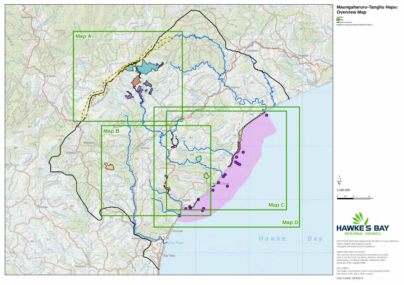
1.4 Information on each statutory acknowledgment, including maps showing the locations of the statutory acknowledgments for each iwi group are presented below.
Statutory Acknowledgements in Hawke’s Bay region 3
Statutory Acknowledgement for Ngati Pahauwera
1 Statutory Acknowledgement
1.1 In accordance with Section 72 of the Ngāti Pāhauwera Treaty Claim Settlement Act 2012, information regarding statutory acknowledgements is hereby attached to the Hawke’s Bay Regional Resource Management Plan and Hawke’s Bay Regional Coastal Environment Plan. This information includes the relevant provisions from the schedules to the Ngāti Pāhauwera Treaty Claim Settlement Act 2012 in full, the description of the Statutory Areas and the statement of association as recorded in the statutory acknowledgements.
2 Statutory Area
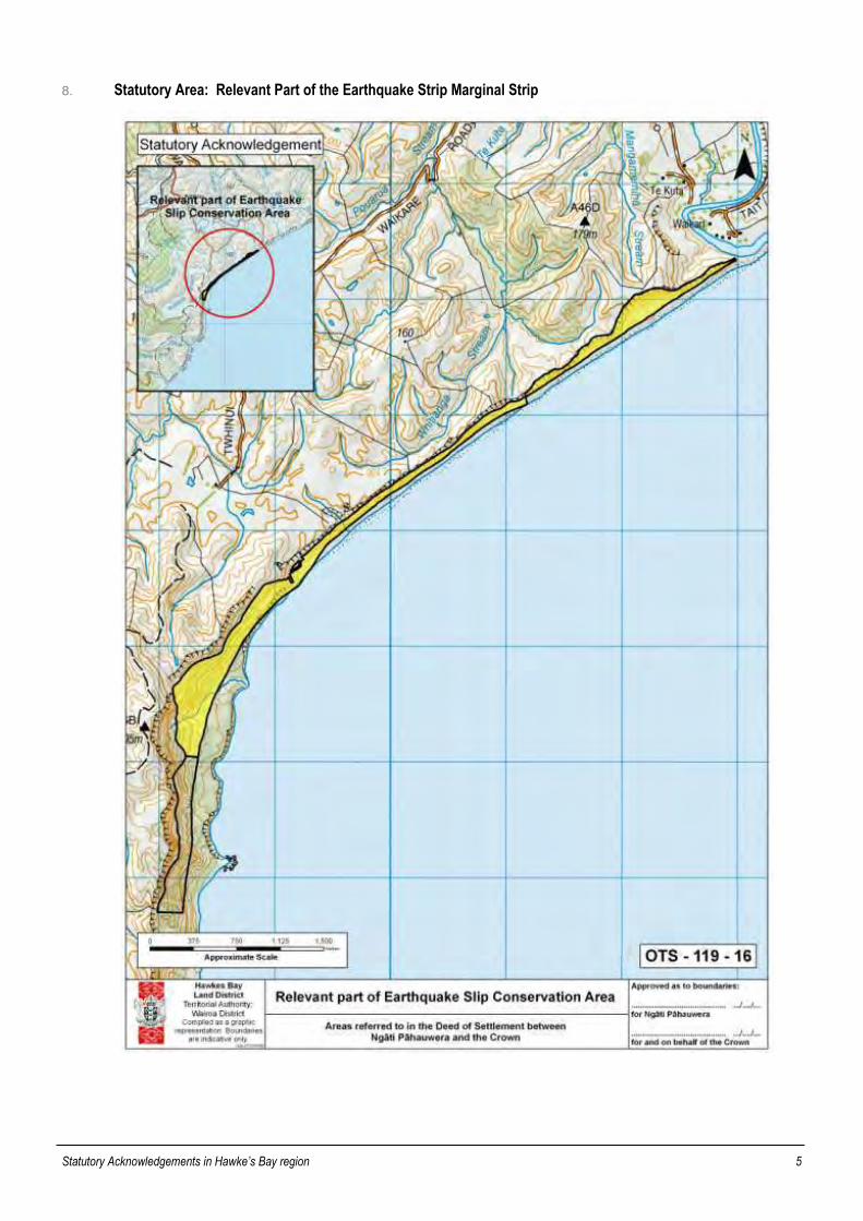
2.1 The area to which this statutory acknowledgement applies is part of the area known Earthquake Slip Marginal Strip, which is located in northern Hawke’s Bay, as shown on the maps contained in Paragraph 8 below.
3 Preamble
3.1 Under Section 67 of the Ngāti Pāhauwera Treaty Claim Settlement Act 2012, the Crown acknowledges Ngāti Pāhauwera’s statement of cultural, spiritual, historical and cultural association with the relevant part of the Earthquake Slip Marginal Strip.
4 Statement of Association
4.1 Tiwhanui (Earthquake Slip) is an important area as a mahinga kai (food gathering area) for whānau or community events such as hakari at the marae, which enables Ngāti Pāhauwera to continue their cultural practices related to mahinga kai.
4.2 Tiwhanui is part of the region along this coast which is known as Taihinu (Bountiful tide), and has long been recognised as an important mahinga kai area. A whakatauāki by tīpuna Tūkapuarangi expresses the bountiful nature of this area:
Whānatu! Hoki mai ki te Waikari
Ki te riu ki te tai
Pātoto i te ata Pātoto i te po
Go! But return to the valley to the sound of fish coming in both day and night
4.3 Tiwhanui has been a recognisable feature of this region at least since the time that commercial whaling began in the Hawke’s Bay, as whalers including Ngāti Pāhauwera, camped in this area during whaling expeditions. Matangi moemoea, the high point behind the slip, was used by whalers as a lookout point.
4.4 Ngāti Pāhauwera have always gathered kai in this area including pāua, kina, kōura (crayfish), karengo, pipi, mussels and, up the Waikari River, flounder, mullet, whitebait, herrings, smelts and kēwai freshwater crayfish. The particular mahinga kai sites are to the south of Tiwhanui, where there are bays for diving, and sites which are obviously suited to camping with available freshwater sources. Ngāti Pāhauwera ancestors traversed the whole of Tiwhanui to reach these sites, utilising caves along the stretch of coast, and there are pa sites to the south of Tiwhanui. They walked along the coast from the mouth of the Mohaka River, fording the Waikari River at high tide to reach the mahinga kai. With the arrival of horses, they would take a number of horses and send the horses back home alone with kai for whānau at home to prepare and dry as appropriate.
4.5 Tiwhanui was also a shelter from the tide, as the rest of the coast in this area is cliffs, and the slip provided the only place of safety at high tide. The distance from home and the tide meant that most expeditions were for a few nights, and Ngāti Pāhauwera ancestors could camp on the slip area as there was also freshwater sources here.
4.6 Ngāti Pāhauwera continue to use Tiwhanui as their ancestors did, using motorbikes instead of horses in some cases. Ngāti Pāhauwera continue to stay overnight to shelter from the tide, and to make the most of the time spent travelling from home. As it is not possible to launch a boat from the mouth of the Mohaka River, Tiwhanui is the only place where Ngāti Pāhauwera can gather some of the kai which is important to them.
5 Purposes of Statutory Acknowledgement
5.1 Pursuant to Section 68 of the Ngāti Pāhauwera Treaty Claim Settlement Act 2012, and without limiting the rest of this schedule, the only purposes of this statutory acknowledgement are:
(a) to require the relevant consent authorities, the Environment Court and the Historic Places Trust to have regard to the statutory acknowledgement, as provided for in Sections 69 to 71;
(b) to require the relevant consent authorities to forward summaries of resource consent applications, or copies of notices of resource consent applications, to the trustees of the Ngāti Pāhauwera Development Trust, as provided for in Section 73;
(c) to enable the trustees of the Ngāti Pāhauwera Development Trust and any member of Ngāti Pāhauwera to cite the statutory acknowledgement as evidence of the association of Ngāti Pāhauwera with the relevant part of the Earthquake Slip Marginal Strip, as provided for in Section 74.
6 Limitations of Effects of Statutory Acknowledgement
6.1 Except as expressly provided in Subpart 6 of Part 2
(a) this statutory acknowledgement does not affect, and may not be taken into account by, a person exercising a power or performing a function or duty under legislation or a bylaw; and
(b) no person, in considering a matter or making a decision or recommendation under legislation or a bylaw, may give greater or lesser weight to the association of Ngāti Pāhauwera with the relevant part of the Earthquake Slip Marginal Strip (as described in the statement of association) than that person would give under the relevant legislation or bylaw if no statutory acknowledgement existed in respect of the relevant part of the Earthquake Slip Marginal Strip.
6.2 Except as expressly provided in Subpart 6 of Part 2, the statutory acknowledgement does not affect the lawful rights or interests of any person who is not a party to the deed of settlement.
Statutory Acknowledgements in Hawke’s Bay region 4
6.3 Except as expressly provided in Subpart 6 of Part 2, the statutory acknowledgement does not have the effect of granting, creating, or providing evidence of an estate or interest in, or rights relating to, the relevant part of the Earthquake Slip Marginal Strip.
7. Relevant sections of the Ngāti Pāhauwera Treaty Claim Settlement Act 2012
67 Statutory acknowledgement by the Crown
The Crown acknowledges the statement of association.
68 Purposes of statutory acknowledgement
(1) The only purposes of the statutory acknowledgement are to—
(a) require relevant consent authorities, the Environment Court, and the Historic Places Trust to have regard to the statutory acknowledgement, as provided for in sections 69 to 71; and
(b) require relevant consent authorities to forward summaries of resource consent applications, or copies of notices of resource consent applications, to the trustees of the Ngāti Pāhauwera Development Trust, as provided for in section 73; and
(c) enable the trustees of the Ngāti Pāhauwera Development Trust and any member of Ngāti Pāhauwera to cite the statutory acknowledgement as evidence of the association of Ngāti Pāhauwera with the relevant part of the Earthquake Slip Marginal Strip, as provided for in section 74.
(2) This section does not limit sections 76 to 78.
69 Relevant consent authorities to have regard to statutory acknowledgement
(1) On and from the effective date, a relevant consent authority must have regard to the statutory acknowledgement in deciding, under section 95E of the Resource Management Act 1991, whether the trustees of the Ngāti Pāhauwera Development Trust are affected persons in relation to an activity within, adjacent to, or directly affecting the relevant part of the Earthquake Slip Marginal Strip and for which an application for a resource consent has been made.
(2) Subsection (1) does not limit the obligations of a relevant consent authority under the Resource Management Act 1991.
70 Environment Court to have regard to statutory acknowledgement
(1) On and from the effective date, the Environment Court must have regard to the statutory acknowledgement for the relevant part of the Earthquake Slip Marginal Strip in deciding, under section 274 of the Resource Management Act 1991, whether the trustees of the Ngāti Pāhauwera Development Trust are persons who have an interest in proceedings that is greater than the interest that the general public has in respect of an application for a resource consent for activities within, adjacent to, or directly affecting the relevant part of the Earthquake Slip Marginal Strip.
(2) Subsection (1) does not limit the obligations of the Environment Court under the Resource Management Act 1991.
71 Historic Places Trust and Environment Court to have regard to statutory acknowledgement
(1) This section applies if, on and after the effective date, an application is made under section 11 or 12 of the Historic Places Act 1993 for an authority to destroy, damage, or modify an archaeological site within the relevant part of the Earthquake Slip Marginal Strip.
(2) The Historic Places Trust must have regard to the statutory acknowledgement in exercising its powers under section 14 of the Historic Places Act 1993 in relation to the application made under subsection (1), including in determining whether the trustees of the Ngāti Pāhauwera Development Trust are persons directly affected by an extension of time.
(3) The Environment Court must have regard to the statutory acknowledgement in determining under section 20 of the Historic Places Act 1993 any appeal from a decision of the Historic Places Trust in relation to the application made under subsection (1), including in determining whether the trustees of the Ngāti Pāhauwera Development Trust are persons directly affected by the decision.
(4) In this section, archaeological site has the same meaning as in section 2 of the Historic Places Act 1993.
Statutory Acknowledgements in Hawke’s Bay region 5
8. Statutory Area: Relevant Part of the Earthquake Strip Marginal Strip
Statutory Acknowledgements in Hawke’s Bay region 6
Statutory Acknowledgement for Maungaharuru-Tangitu
1. Statutory Acknowledgement
1.1 In accordance with Section 43 of the Maungaharuru-Tangitū Hapū Claims Settlement Act 2014 information regarding statutory acknowledgements is hereby attached to the Hawke’s Bay Regional Resource Management Plan and Hawke’s Bay Regional Coastal Environment Plan. This information includes the relevant provisions from the schedules to the Maungaharuru-Tangitū Hapū Claims Settlement Act 2014 in full, the description of the Statutory Areas and the statement of association as recorded in the statutory acknowledgements.
2. Statutory Areas
2.1. The areas to which this statutory acknowledgement applies are (alphabetically):
ID Area/Feature
Deed of Settlement
Map Reference
RRMP Map Reference
20, 29 Anaura Stream and its tributaries As shown on OTS-201-32 Map E
24, 24 Aropaoanui River and its tributaries As shown on OTS-201-33 Map E
7 Balance of the Opouahi Scenic Reserve As shown on OTS-201-31 Map A
18 Balance of the Tutira Domain Recreation Reserve As shown on OTS-201-30 Map B
8 Bellbird Bush Scenic Reserve As shown on OTS-201-47 Map A
9 Boundary Stream Scenic Reserve As shown on OTS-201-46 Map A
11, 16 Earthquake Slip Marginal Strip As shown on OTS-201-20 Map D
5 Esk Kiwi Sanctuary Area As shown on OTS-201-22 Map B
20, 21 Esk River and its tributaries As shown on OTS-201-34 Map E
10 Hapū Coastal Marine Area As shown on OTS-201-40 Map C
20, 26 Mahiaruhe Stream and its tributaries As shown on OTS-201-35 Map E
14 Mangapukahu Scenic Reserve As shown on OTS-201-25 Map B
11, 15 Moeangiangi Marginal Strip As shown on OTS-201-21 Map D
20, 27 Moeangiangi River and its tributaries As shown on OTS-201-39 Map E
20, 22 Pākuratahi Stream and its tributaries As shown on OTS-201-45 Map E
4 Peaks of Maungaharuru Range As shown on OTS-201-29 Map A
10 Rocks and Reefs As shown on OTS-201-41 Map C
20, 25 Sandy Creek and its tributaries As shown on OTS-201-43 Map E
19 Tangoio Falls Scenic Reserve As shown on OTS-201-23 Map B
11 Tangoio Marginal Strip As shown on OTS-201-49 Map B
17 Te Kuta Recreation Reserve As shown on OTS-201-26 Map D
20, 23 Te Ngarue Stream and its tributaries As shown on OTS-201-36 Map E
20, 28 Waikari River and its tributaries As shown on OTS-201-37 Map E
6 Waikoau Conservation Area As shown on OTS-201-28 Map A
20, 24 Waikoau River and its tributaries As shown on OTS-201-38 Map E
11 Waipatiki Beach Marginal Strip As shown on OTS-201-50 Map D
13 Waipatiki Scenic Reserve As shown on OTS-201-27 Map D
20, 30 Waitaha Stream and its tributaries As shown on OTS-201-44 Map E
11, 12 Whakaari Landing Place Reserve As shown on OTS-201-48 Map B
19 White Pine Bush Scenic Reserve As shown on OTS-201-24 Map B
3. Preamble
3.1. Under Section 38 of the Maungaharuru-Tangitū Hapū Claims Settlement Act 2014, the Crown acknowledges Maungaharuru-Tangitū Hapū’s statement of cultural, spiritual, historical and cultural association with the following:
Statutory Acknowledgements in Hawke’s Bay region 7
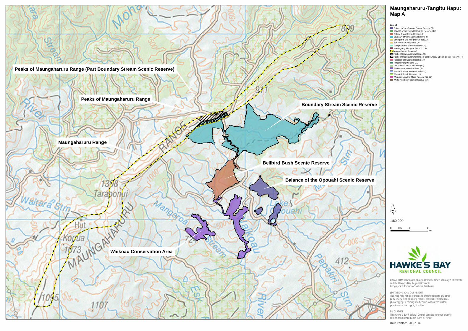
4. Peaks of Maungaharuru Range (as shown on OTS-201-29 & HBRC Map A)
4.1. For the Hapū, the peaks of Maungaharuru (the Maungaharuru Range) and environs are integral to the distinct identity and mana of the Hapū. They are some of the most sacred and important physical landmarks within the takiwā (traditional area) of the Hapū.
4.2. Spiritual importance
Maungaharuru is the iconic, most sacred and spiritual maunga (mountain) of the Hapū. Maungaharuru has a mauri (life force) of its own. This mauri binds the spiritual world with the physical world. All elements of the natural world have mauri and it is this mauri that connects the Hapū with Maungaharuru. Mauri is therefore the basis of the spiritual relationship of the Hapū with Maungaharuru.
4.3. The Hapū regard all natural resources as being gifts from ngā atua kaitiaki (spiritual guardians), including the ngahere (forest) upon Maungaharuru. Tāne-nui-a-rangi is the spiritual guardian of the ngahere and all that lives within the ngahere. Tāne-nui-a-rangi is the son of Papa-tū-ā-nuku (Earth Mother) and Rangi-nui (Sky Father), from whom all living things descend, including the Hapū. Descendants of Tāne-nui-a-rangi include the manu (birds) and trees (rākau) within the ngahere. Therefore, both the descendants of Tāne-nui-a-rangi and the descendants of the Hapū are connected by whakapapa (genealogy). Tāne-nui-a-rangi was central to the lives of Hapū tīpuna (ancestors) and remains significant to the Hapū whānau (families) living today.
4.4. Hapū kaumātua (elders) and kaikōrero (speakers) acknowledge the “tihi tapu o Maungaharuru” -“the sacred peaks of the maunga”. The paramount status of Maungaharuru is recognised by the Hapū in their mihi (greetings), whaikōrero (formal speeches), whakairo (carvings), kōwhaiwhai (painted panels) and tukutuku (woven panels) on their marae, whakatauākī (tribal proverbs), kōrero tuku iho (Hapū history) and waiata (songs).
4.5. Cultural importance - Whakatauākī
Ka tuwhera a Maungaharuru, ka kati a Tangitū, Ka tuwhera a Tangitū, ka kati a Maungaharuru.
When the season of Maungaharuru opens, the season of Tangitū closes, When the season of Tangitū opens, the season of Maungaharuru closes.
4.6. According to kōrero tuku iho, this whakatauākī:
describes the takiwā of the Hapū – from Maungaharuru in the west, to Tangitū (the sea) in the east; and
it proclaims ahi-kā-roa (long occupation) of the Hapū and the inherited right as tāngata whenua to exercise mana whenua and mana moana.
4.7. The relationship the Hapū have with Maungaharuru is culturally significant and provides whānau with a strong sense of place and belonging to the takiwā. It is still customary practice for Hapū members to recite this whakatauākī to identify where they come from and the relationship that connects them to the natural world.
4.8. Hapū kaumātua also emphasise the connectedness of Maungaharuru with Tangitū. The waters flowing from the maunga feed the rivers, lakes, wetlands and sea - the realm of Tangaroa-i-te-Rupetu (the spiritual guardian of the sea and other water bodies and all that lives within them).
4.9. The whakatauākī also describes the mahinga kai (places for gathering food) of the Hapū. The ngahere on Maungaharuru was the source of food for the Hapū in the winter. Tangitū was, and remains, the source of food in the summer. While the Hapū collected food on a seasonal basis, they were blessed in that they did not need to leave their takiwā in search of food. Hence another Hapū whakatauākī “ko tō rātau pā kai ngā rekereke”, “their fortified villages were in their heels”.
4.10. In the past, Maungaharuru was bountiful. From the domain of Tāne-nui-a-rangi, the Hapū sourced their kai (food). They gathered aruhe (fern root), pikopiko (young fern shoots), the raurau (leaves) of the tī kōuka (cabbage tree), berries and huhu (edible grubs) and caught manu. Rongoā (medicinal plants), bark, fern fronds and timber for building materials, flowers for pigments, leaves and seeds for oils, paru (special mud) for dyes and other resources were also gathered.
4.11. Maungaharuru was also integral to the economy of the Hapū – kai and resources gathered from the maunga were often traded with their neighbours.
4.12. This whakatauākī also implies that the manuhiri (visitors) of the Hapū will be served kai from Maungaharuru and Tangitū. The ability to offer the range and quality of kai the Hapū had from their takiwā enhanced their mana.
4.13. In addition, the gathering of kai and resources has the reciprocal obligation of the Hapū to act as kaitiaki (guardians). The Hapū had tohu (signs) and tikanga (customs) which dictated the appropriate time and practices for gathering food and resources from Maungaharuru. Mātauranga (knowledge) associated with the collection of resources was central to the lives of the Hapū and remains a significant part of the cultural identity of the Hapū today. Mātauranga and associated tikanga, karakia (prayers) and kawa (rules) are all essential for maintaining customary traditions -the ritual and tapu (sacredness) associated with gathering and utilising resources.
4.14. Kōrero tuku iho – historical importance.
Others sometimes refer to different parts of the maunga using different names, namely from south to north: Te Waka, Tītī-a-Okura (this is the name known to the Hapū, Titiokura is the official name), Maungaharuru and Te Heru-a-Tureia. However, when the Hapū speak of Maungaharuru, they are referring to the maunga in its entirety.
4.15. The Hapū have a rich history relating to Maungaharuru. To this day, the North Island of New Zealand is known as Te Ika-a-Māui (Māui’s fish). Hapū tradition tells that when Māui-tikitiki-a-Taranga pulled up the fish, the waka (canoe) that Māui and his whānau were on became stranded on top of the mighty fish. At the time, Māui warned his Uncle, Ngārangikataka, and others not to touch or cut up the fish. But they did not listen. They began to cut up the fish, creating the peaks and valleys that are seen today. Māui was angry, and turned his Uncle and the waka to stone. Others tried to escape to the sea, towards Tangoio, but they too were turned to stone. Today they are in the form of Panepaoa, a small hill located just south of the Pākuratahi (formerly Pakuratahi) Stream and nearby Ngāmoerangi, located on the Tangitū coastline. Te Waka-o-Ngārangikataka (Ngārangikataka’s canoe) can also be seen, high on the ridgeline of Maungaharuru.
4.16. Oral tradition recounts the migration of the waka Tākitimu southwards, and a tohunga (high priest) of the waka, Tūpai, who cast the staff Papauma high into the air. Papauma took flight and landed on the maunga at the summit of Tītī-a-Okura, at a place called Tauwhare Papauma.
Statutory Acknowledgements in Hawke’s Bay region 8
4.17. Papauma embodied the mauri of birdlife. The maunga rumbled and roared on receiving this most sacred of taonga (treasures), and the maunga was proliferated with birdlife. Hence the name, Maungaharuru (the mountain that rumbled and roared). It is also said that the mountain roared every morning and evening as the many birds took flight and returned again to the maunga.
4.18. Significant pā (fortified villages) are located on Maungaharuru and attest to the occupation of the Hapū over the generations. Towards the southern part of the maunga, pā were occupied by Ngāi Tauira and Ngāti Marangatūhetaua (Ngāti Tū), on the central part of the maunga, Ngāti Kurumōkihi, and towards the northern part of the maunga, Ngāi Tahu.
4.19. Ngāti Tū occupied Te Pōhue pā at the head of Lake Te Pōhue, and the nearby kāinga (villages) of Kaitahi and Whāngai Takapu.
4.20. Several pā relate to Ngāi Tauira and its eponymous ancestor, Tauira and his wife, Mateawha. Pirinoa pā is situated at the tauihu (prow) of Te Waka-o-Ngārangikataka. Taurua-o-Ngarengare pā is located at the south end of Te Waka part of the Maungaharuru range and is named after one of their sons. Tauwhare Papauma, referred to earlier, became a pā of Tauira.
4.21. The story of Mateawha also relates to an important wāhi tapu (sacred place) on the maunga. Mateawha was one of the Tūrehu people – she was not human and her people abided by certain rules. One day Tauira and Mateawha had visitors, and sadly, Tauira forgot himself. He told his wife to carry out work that caused her to violate the rules of her people. The effect was to ‘whakanoa te tapu i runga i a ia’ - ‘to nullify the sacredness of Mateawha’. The implication was that Mateawha was unable to return to her own Tūrehu people and became alienated from them. She was so distraught at the situation, that she took her own life by throwing herself off the cliff face. She hit the side of the rock and fell down into what is known today as Hell’s Hole. The stain of her blood was left and since that time, whenever that stain congeals, the Hapū recognise it as an aituā – a bad omen. The site is referred to as Te Pari-o-Mateawha – Mateawha’s cliff.
4.22. Maungaharuru, and in particular its ridges towards the southern end of the range, are known as “te mauri o te māra o Tauira” – “the garden over which the life force of Tauira still remains”. The maunga was a source of sustenance for Tauira and his descendants over many generations.
4.23. Tītī-a-Okura is the pass where tītī (muttonbirds) flew over Maungaharuru. Te Mapu and his son Te Okura caught tītī there using a net attached between two poles held high by them in front of a fire. Hence the name, Tītī-a-Okura – the mutton birds of Okura. Another feature is Te Waka-a-Te-O – The canoe of Te O. This rock is located on Tītī-a-Okura and commemorates Te Okura, also known as “Te O”.
4.24. Several significant wāhi tapu are positioned on Maungaharuru. Ahu-o-te-Atua (formerly named Ahuateatua) - the sacred mound of the Gods, is situated at the north eastern end of Maungaharuru. Oral tradition describes Ahu-o-te-Atua as an altar where tohunga gathered to carry out their spiritual ceremonies. A tarn (mountain lake), one of two located on the eastern side of Te Waka-o-Ngārangikataka, is known to have unusual colouration due to the paitini (toxic) nature of the water.
4.25. Tarapōnui-a-Kawhea (as it is known to the Hapū, the official name is Taraponui) – the high peak of Kawhea enveloped with cloud, is the northern most and highest peak on Maungaharuru and is therefore very sacred. The name is ancient and dates from the excursions of Kurupoto and his son Kawhea into the area. Tarapōnui-a-Kawhea was once the regular track for the Hapū from Tūtira toTe Haroto through Waitara.
4.26. Oral tradition provides that Tāne-nui-a-rangi and his ngahere provided a korowai (cloak) for Papatū-ā-nuku (his mother). Accordingly, prior to the clearing of native forests and pastoralism, Maungaharuru was home to a wide range of animal and plant species which were, and remain, of great significance to the Hapū. Today, there is a significantly reduced area of native forest.
4.27. The remnant and regenerating areas of native forest on Maungaharuru include tawa, tītoki, rewarewa (New Zealand honeysuckle), kāmahi, kānuka (white tea-tree), tawhairaunui (red beech) and tawhairauriki (black beech) and mānuka (tea tree). The nationally significant ngutu-kākā (kakabeak) is also found on Maungaharuru.
4.28. The ngahere provided the ideal habitat for a large number of manu including tītī (muttonbird), kiwi, kārearea (native falcon), kākā (native parrot), kererū (native pigeon) and tūī (parson bird). Many of these taonga were harvested for a range of uses, including kai, rongoā, clothing (including feathers for decorating garments and personal adornments), building materials, trade and gifting.
4.29. The Hapū have cultural, spiritual, traditional and historic associations with Maungaharuru and its environs, its waters, associated land and flora and fauna. The Hapū have a responsibility as kaitiaki in accordance with their kawa and tikanga to restore, protect and manage all those natural and historic resources and sites. This relationship is as important to present day whānau as it was to their tīpuna. The continued recognition of the Hapū, their identity, traditions and status as kaitiaki is entwined with the peaks of Maungaharuru.
5. Esk Kiwi Sanctuary Area (as shown on OTS-201-22 & HBRC Map B)
5.1. The Esk Kiwi Sanctuary Area (the Reserve), is located near Te Pōhue at the south eastern end of the Maungaharuru Range (Maungaharuru). The importance of the Reserve is due to its location within the traditional area of Ngāti Marangatūhetaua (Ngāti Tū) and Ngāi Tauira and near their pā (fortified villages), kāinga (villages), wāhi tapu (sacred places), mahinga kai (places for gathering food) and other significant sites. The following statement of association is relevant to the Reserve.
Peaks of Maungaharuru Range.
5.2. Te Pōhue was a large pā, located at the head of Te Pōhue Lake and in the shadow of the maunga (mountain). The summit of the pā, formerly encircled by large tōtara fortifications, had commanding views of the surrounding countryside. From there, Ngāti Tū could survey the surrounding lands including the Reserve. Also nearby were the Ngāti Tū kāinga, Kaitahi and Whāngai Takapu. The significance of this area is also demonstrated by the placement of pou(posts) which were named after key tīpuna including Tūkapua, after the eponymous ancestor Tūkapua I for Ngāti Tū and Kaitahi, a key tīpuna for Ngāi Tauira.
5.3. Te Pōhue area, including the Reserve, has always been part of the arterial route from the coast to the interior, in traditional times with the proliferation of walking tracks, as well as in recent times with the old Taupo Coach Road and today with State Highway 5. In the past, the key walking tracks through this area saw the seasonal passage of the Hapū in the summer to Tangitū and in the winter to Maungaharuru. For this reason, this area has constantly been a significant, strategic location, and the Hapū defended their interests in this land over many generations.
5.4. The Reserve is important as it is one of the few areas of remnant and regenerating native forest. It is home to stands of large kānuka (white tea-tree), māhoe (whiteywood), mamaku (black tree fern), and rewarewa (New Zealand honeysuckle), an important rongoā (medicinal plant). Many manu (birds) are found there including kiwi, ruru (morepork), tīwaiwaka (fantail), kererū (native pigeon), mātātā (fernbird), riroriro (grey warbler), kōtare (kingfisher), korimako (bellbird), miromiro (tomtit), pihipihi (silvereye) and tūī (parson bird). The Hapū caught manu for various reasons, including for kai (food) and preserving for trade or gifting with neighbouring iwi. Their feathers were used by the Hapū for decorating clothing and personal adornment.
Statutory Acknowledgements in Hawke’s Bay region 9
5.5. The Hapū have cultural, spiritual, traditional and historic associations with the Reserve and its environs, its waters, associated land and flora and fauna. The Hapū have a responsibility as kaitiaki (guardians) in accordance with their kawa (rules) and tikanga (customs) to restore, protect and manage all those natural and historic resources and sites. This relationship is as important to present day whānau (families) as it was to their tīpuna (ancestors). The continued recognition of the Hapū, their identity, traditions and status as kaitiaki is entwined with Maungaharuru, including the Reserve and associated resources.
6. Waikoau Conservation Area (as shown on OTS-201-28 & HBRC Map A)
6.1. The Waikoau Conservation Area (the Reserve) and environs are integral to the distinct identity and mana of Ngāti Kurumōkihi. The importance of the Reserve derives from its position along the eastern slopes of Maungaharuru (the Maungaharuru Range) within the Ahu-o-te-Atua (formerly named Ahuateatua) and Tarapōnui-a-Kawhea (as it is known to the Hapū, the official name is Taraponui) areas of Maungaharuru, and its proximity to Lake Opouahi. The Waikoau River flows through the Reserve. Accordingly, the following statements of association are relevant to the Reserve.
Peaks of Maungaharuru Range;
Balance of the Opouahi Scenic Reserve; and
Waikoau and Aropaoanui Rivers and their tributaries.
6.2. Kōrero tuku iho – historical importance
In addition to Ngāti Kurumōkihi, Waikoau is also associated with Whakairo, the great grandson of Tauira and Mateawha. He appears from time to time at the edges of the bush in the Waikoau area as a fully tattooed warrior. During his lifetime, he occupied Te Onepu pā on the Waikoau River and was known to have traversed a wide area covering Tītī-a-Okura, Ohurakura, Pūrahoitangihia and Tūtira.
6.3. In Waikoau, plentiful flora and fauna were available for harvesting. These taonga (treasures) were harvested for a range of uses, including kai, rongoā (medicinal plants), clothing (including feathers for decorating garments and personal adornments), building materials, trade and gifting. Today, the Reserve consists of mainly scrub and low forest of mānuka (tea tree) and kānuka (white teatree) with some tītoki and tawa.
6.4. The Hapū have cultural, spiritual, traditional and historic associations with the Reserve and its environs, its waters, associated land and flora and fauna. The Hapū have a responsibility as kaitiaki (guardians) in accordance with their kawa (rules) and tikanga (customs) to restore, protect and manage all those natural and historic resources and sites. This relationship is as important to present day whānau (families) as it was to their tīpuna (ancestors). The continued recognition of the Hapū, their identity, traditions and status as kaitiaki is entwined with Maungaharuru, including the Reserve and associated resources.
7. Balance of the Opouahi Scenic Reserve (as shown on OTS-201-31 & HBRC Map A)
7.1. For Ngāti Kurumōkihi, the balance of the Opouahi Scenic Reserve (the Reserve) and environs are integral to the distinct identity and mana of the Hapū. The importance of the Reserve derives from its position along the eastern slopes of Maungaharuru (the Maungaharuru Range) and the location of Lake Opouahi within the Reserve. Accordingly the following statement of association is relevant to the Reserve.
Peaks of Maungaharuru Range.
7.2. Spiritual importance
Lake Opouahi is regarded as a particularly spiritual place of Ngāti Kurumōkihi. The tuna (eels) were renowned as being unique to Lake Opouahi. Oral traditions tell of tuna known as the kēhua tuna (ghost eels). The tuna would often challenge whānau (families) in defiance of being harvested. They were famed as the kaitiaki (guardian) of Ngāti Kurumōkihi and the area. Also in this area appeared a tipua (a supernatural being) in a form similar to a white pig. This tipua was revered as a tohu (sign) and would appear at a time of misfortune, either after the event, or as a warning. Patupaiarehe (fairies) are also known to dwell in the area.
7.3. Kōrero tuku iho – historical importance
Nearby the Reserve and at the foot of Maungaharuru are several pā (fortified villages) that are associated with Ngāti Kurumōkihi and are still identifiable today. They are Kokopuru and Matarangi. Kokopuru pā was built on the hill of the same name. Kokopuru pā was heavily fortified and surrounded by extensive cultivations, wāhi tapu (sacred places), midden, ovens and cave shelters. According to a source who visited the pā in 1882, the main defensive structures were, at that time, almost intact, with heavy palisades of upright tōtara poles and boughs stood in a circular formation around the hill.
7.4. Close by is Matarangi pā, on a peak near Lake Opouahi. The pā was formerly surrounded by cultivations where kūmara (sweet potatoes) and taewa (potatoes) were grown and the water supply came from two lakelets – Ngā Ipu-o-Te-Amohia. Another prominent feature was a carved meeting house which was unfortunately destroyed during a skirmish with a warparty. Over the generations, a number of Ngāti Kurumōkihi chiefs, including Waiatara, based themselves at Kokopuru and Matarangi.
7.5. In the vicinity of Lake Opouahi are a number of caves that are also known to have been occupied from time to time, and some are the ancestral resting place for tīpuna (ancestors).
7.6. The Reserve is one of the few areas of remnant and regenerating native ngahere (forest) on Maungaharuru. It is located at an altitude of 500 to 700 metres above sea level.
7.7. In this area, plentiful flora and fauna were available for harvesting. In particular, rongoā (medicinal plants) were abundant, including red matipo, māwe, parapara, harakeke (flax), mānuka (tea tree), kāmahi, tawa, rewarewa (New Zealand honeysuckle) and tātarāmoa (bramble / bush lawyer).
7.8. The ngahere provided the ideal habitat for a large number of native birds including kiwi, kārearea (native falcon), kākā (native parrot), kererū (native pigeon) and tūī (parson bird). Many of these birds were harvested for kai (food) and their feathers used for decorating garments and personal adornments.
7.9. Lake Opouahi and its associated waterways were also significant sources of kai for the Hapū. The lake and waterways supplied uniquely tasting tuna, kākahi (freshwater mussels), kōura (freshwater crayfish) and kōkopu (freshwater fish), as well as the daily water supply for the Hapū, as Lake Opouahi is a deep, spring-fed lake.
7.10. The Hapū have cultural, spiritual, traditional and historic associations with the Reserve and its environs, its waters, associated land and flora and fauna. The Hapū have a responsibility as kaitiaki in accordance with their kawa (rules) and tikanga (customs) to restore, protect and manage all those
Statutory Acknowledgements in Hawke’s Bay region 10
natural and historic resources and sites. This relationship is as important to present day whānau (families) as it was to their tīpuna (ancestors). The continued recognition of the Hapū, their identity, traditions and status as kaitiaki is entwined with Maungaharuru, including the Reserve and associated resources.
8. Bellbird Bush Scenic Reserve (as shown on OTS-201-47 & HBRC Map A)
8.1. For Ngāti Kurumōkihi, the Bellbird Bush Scenic Reserve (the Reserve) and environs are integral to the distinct identity and mana of the Hapū. The importance of the Reserve derives from its position high along the eastern slopes of Maungaharuru (the Maungaharuru Range) within the Ahu-o-te-Atua (formerly named Ahuateatua) and Tarapōnui-a-Kawhea (as it is known to the Hapū; the official name is Taraponui) areas of Maungaharuru, and its proximity to Lake Opouahi. It is also bisected by the Waikoau River. Accordingly, the following statements of association are relevant to the Reserve:
Peaks of Maungaharuru Range;
Balance of the Opouahi Scenic Reserve; and
Waikoau and Aropaoanui Rivers and their tributaries.
8.2. The Reserve is one of the few areas of remnant and regenerating native ngahere (forest) on Maungaharuru. It is located in moderate to steep terrain at an altitude of 700 metres above sea level. Consequently, it consists of diverse ngahere of tawhairaunui (red beech), kāmahi, mānuka (tea tree) and kānuka (white tea-tree). Other tree species include tawhairauriki (black beech), rewarewa (New Zealand honeysuckle), māhoe (whiteywood), horoeka (lancewood) and maire. The ngahere provided the ideal habitat for a large number of native birds including huia (before it became extinct), kiwi, kārearea (native falcon), kākā (native parrot), kererū (native pigeon), koekoeā (long-tailed cuckoo), korimako (bellbird) and tūī (parson bird). Many of these taonga (treasures) were harvested for a range of uses, including kai (food), rongoā (medicinal plants), clothing (including feathers for decorating garments and personal adornments), building materials, trade and gifting.
8.3. The Hapū have cultural, spiritual, traditional and historic associations with the Reserve and its environs, its waters, associated land and flora and fauna. The Hapū have a responsibility as kaitiaki (guardians) in accordance with their kawa (rules) and tikanga (customs) to restore, protect and manage all those natural and historic resources and sites. This relationship is as important to present day whānau (families) as it was to their tīpuna (ancestors). The continued recognition of the Hapū, their identity, traditions and status as kaitiaki is entwined with Maungaharuru, including the Reserve and associated resources.
9. Boundary Stream Scenic Reserve (as shown on OTS-201-46 & HBRC Map A)
9.1. For Ngāti Kurumōkihi, the Boundary Stream Scenic Reserve (the Reserve) and environs are integral to the distinct identity and mana of the Hapū. The importance of the Reserve derives from its position high along the eastern slopes of the Maungaharuru Range (Maungaharuru) within the Ahu-o-te-Atua (formerly named Ahuateatua) and Tarapōnui-a-Kawhea (as it is known to the Hapū, the official name is Taraponui) areas of Maungaharuru, and its proximity to Lake Opouahi. The Waikoau River and Boundary Stream flow within the Reserve, and Shine Falls is located in the eastern part of the Reserve. Accordingly, the following statements of association are relevant to the Reserve:
Peaks of Maungaharuru Range;
Balance of the Opouahi Scenic Reserve; and
Waikoau and Aropaoanui Rivers and their tributaries.
9.2. The Reserve is one of the few areas of remnant and regenerating native ngahere (forest) on Maungaharuru. It is located in moderate to steep terrain at varying altitudes of 300 to 980 metres above sea level. Consequently, the ngahere has a range of vegetation. It has a heavy forest cover of tawa, tītoki and rewarewa. Other tree species include tawhairauriki (black beech), kāpuka, pāpāuma, kāmahi, kānuka (white tea-tree), tawhairaunui (red beech), kōwhai, mamaku (black tree fern), ponga (silver tree fern), maire, kahikatea (white pine), rimu (red pine), mataī (black pine) and tōtara. The rare and nationally significant ngutu-kākā (kākā beak) has also been found in the reserve in recent times. The ngahere provided the ideal habitat for a large number of native birds including huia (before it became extinct), kiwi, kārearea (native falcon), kākā (native parrot), kererū (native pigeon), koekoeā (long-tailed cuckoo) and tūī (parson bird). Many of these taonga (treasures) were harvested for a range of uses, including kai (food), rongoā (medicinal plants), clothing (including feathers for decorating garments and personal adornments), building materials, trade and gifting.
9.3. The Hapū have cultural, spiritual, traditional and historic associations with the Reserve and its environs, its waters, associated land and flora and fauna. The Hapū have a responsibility as kaitiaki (guardians) in accordance with their kawa (rules) and tikanga (customs) to restore, protect and manage all those natural and historic resources and sites. This relationship is as important to present day whānau (families) as it was to their tīpuna (ancestors). The continued recognition of the Hapū, their identity, traditions and status as kaitiaki is entwined with Maungaharuru, including the Reserve and associated resources.
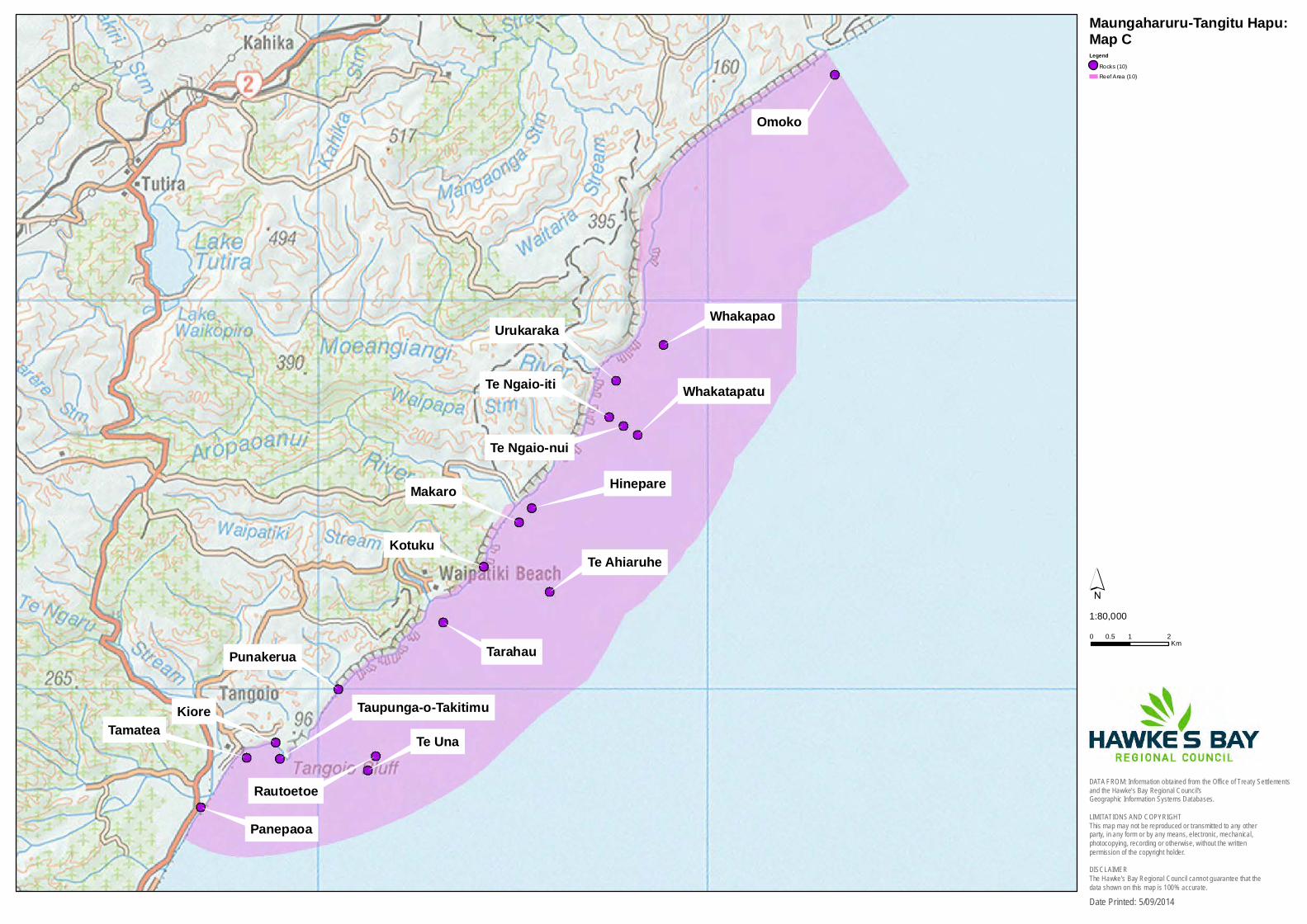
10. Rocks and Reefs and Hapū Coastal Marine Area (as shown on, respectively, OTS-201-41 and OTS-201-40, & HBRC Map C)
10.1. For the Hapū, the rocks and reefs along the coastline (Rocks and Reefs) and the Hapū Coastal Marine Area and environs are integral to the distinct identity and mana of the Hapū and are significant because they are located within Tangitū (the sea).
10.2. Spiritual importance
Tangitū is vital to the Hapū. Tangitū has a mauri (life force) of its own. This mauri binds the spiritual world with the physical world. All elements of the natural world have mauri and it is this mauri that connects the Hapū with Tangitū. Mauri is therefore the basis of the spiritual relationship of the Hapū with Tangitū.
10.3. The Hapū regard all natural resources as being gifts from ngā atua kaitiaki (spiritual guardians), including those within Tangitū. Tangitū is within the domain of Tangaroa-i-te-Rupetu (Tangaroa), the spiritual guardian of the moana (sea) and waterbodies, and all within them. Tangaroa is the son of Papa-tū-ā-nuku (Earth Mother) and Rangi-nui (Sky Father), from whom all living things descend, including the Hapū. Descendants of Tangaroa include the whales, waves, ocean currents and fish life within the moana. Therefore, both the descendants of Tangaroa and the descendants of the Hapū are connected by whakapapa (genealogy). Tangaroa was central to the lives of the Hapū tīpuna (ancestors) and remains significant to the Hapū whānau (families) living today.
10.4. Hapū kaumātua and kaikōrero acknowledge the importance of Tangitū. Tangitū provides cultural, spiritual and physical sustenance, and as such, shapes the identity of the Hapū. The principal status of Tangitū is recognised by the Hapū in their mihi (greetings), whaikōrero (formal speeches),
Statutory Acknowledgements in Hawke’s Bay region 11
whakairo (carvings), kōwhaiwhai (painted panels) and tukutuku (woven panels) on their marae, whakatauākī (tribal proverbs), kōrero tuku iho (Hapū history) and waiata (songs).
10.5. Cultural importance - Whakatauākī
Ka tuwhera a Maungaharuru, ka kati a Tangitū,
Ka tuwhera a Tangitū, ka kati a Maungaharuru.
When the season of Maungaharuru opens, the season of Tangitū closes,
When the season of Tangitū opens, the season of Maungaharuru closes.
10.6. According to kōrero tuku iho, this whakatauākī:
describes the takiwā (traditional area) of the Hapū – from Maungaharuru (the Maungaharuru range) in the west, to Tangitū (the sea) in the east; and,
it proclaims ahi-kā-roa (long occupation) of the Hapū and the inherited right as tāngata whenua to exercise mana whenua and mana moana.
10.7. The relationship the Hapū have with Tangitū is culturally significant and provides whānau with a strong sense of place and belonging to the takiwā. It is still customary practice for Hapū members to recite this whakatauākī to identify where they come from and the relationship that connects them to the natural world.
10.8. Hapū kaumātua also emphasise the connectedness of Maungaharuru with Tangitū. The waters flowing from the maunga (mountain) feed the streams, rivers, aquifers, lakes, wetlands and sea - the realm of Tangaroa.
10.9. The whakatauākī also describes the mahinga kai (places for gathering food) of the Hapū. The ngahere (forest) on Maungaharuru was the source of food for the Hapū in the winter. Tangitū was, and remains, the source of food in the summer. While the Hapū collected food on a seasonal basis, they were blessed in that they did not need to leave their takiwā in search of food. Hence another Hapū whakatauākī:
“ko tō rātau pā kai ngā rekereke”, “their fortified villages were in their heels”.
10.10. The Rocks and Reefs and Hapū Coastal Marine Area were traditionally a vital food source for the Hapū, and in the past, kaimoana (seafoods) were in plentiful supply. From the domain of Tangaroa the Hapū sourced their kai (food). They caught ika (fish), tuna (eels), īnanga and ngaore (forms of whitebait) and kōura (crayfish) and gathered kuku (mussels), kina (sea urchin) and pāua (abalone). Rongoā (medicinal plants) such as kaiō (sea tulip) and sea water were also collected for medicinal purposes. Other resources that were gathered included tāwhaowhao (driftwood), pungapunga (pumice) and rimurimu (bull kelp) for storing tītī (muttonbirds).
10.11. Tangitū was also integral to the economy of the Hapū – kai and resources gathered from Tangitū were often traded with their neighbours.
10.12. This whakatauākī also implies that the manuhiri (visitors) of the Hapū will be served kai from Maungaharuru and Tangitū. The ability to offer the range and quality of kai the Hapū had from their takiwā enhanced their mana.
10.13. In addition, the gathering of kai and resources has the reciprocal obligation of the Hapū to act as kaitiaki (guardians). The Hapū had tohu (signs) and tikanga (customs) which dictated the appropriate time and practices for gathering food and resources from Tangitū. Mātauranga (knowledge) associated with the collection of resources was central to the lives of the Hapū and remains a significant part of the cultural identity of the Hapū today. Mātauranga and associated tikanga, karakia (prayers) and kawa (rules) are all essential for maintaining customary traditions - the ritual and tapu (sacredness) associated with gathering and utilising resources.
10.14. Kōrero tuku iho – historical importance
10.15. Tīpuna recounted that Tangitū is named after a strong-willed young woman from the takiwā. Tangitū was an excellent diver and collector of kaimoana who could stay submerged for long periods of time. Against advice, Tangitū went diving into a hole from which she never returned. Tangitū manifested herself as a whale and is an important kaitiaki for the Hapū. According to tradition, if tikanga or kawa were not properly observed when gathering kaimoana or other resources, Tangitū the kaitiaki would appear. The Hapū believe that, as a kaitiaki, Tangitū has the power to protect her people, particularly in the event of natural disasters. She has been known to use her tail to unblock the mouth of Te Ngarue (formerly Te Ngaru) Stream and Pākuratahi (formerly Pakuratahi) Stream, or lie across the mouth as protection in the event of high seas.
10.16. There are other kaitiaki who live in Tangitū, including Uwha, at Arapawanui, who takes the form of an eel or octopus, and Moremore, the son of Pania (of the reef), who swims the coastline in the form of a mako (shark).
10.17. Also associated with Tangitū is the story of Ruawharo. Ruawharo was a tohunga (high priest) aboard the waka (canoe) Tākitimu on its migration to Aotearoa. He gathered sands from Hawaiki and took them aboard the waka. The sands held the mauri of fishlife. Ruawharo and his wife Hine-Wairakaia had three sons; Matiu, Makaro and Moko-tu-a-raro. To extend the mauri of fishlife, Ruawharo placed his children along the coast at Waikokopu in Te Māhia and between Rangatira and Te Ngaruroro. Significantly for the Hapū, Makaro was placed at Arapawanui to instil the mauri of fishlife along the coastline.
10.18. Along the coast and nearby were significant mahinga kai and places associated with such activities, as follows.
The mouths of the Waikari, Moeangiangi, Aropaoanui (known to the Hapū as Arapawanui), Waipātiki (formerly Waipatiki) River, Te Ngarue (formerly Te Ngaru) Stream and Pākuratahi (formerly Pakuratahi) Stream.
Tiwhanui is identified by the Hapū as the highest place along the cliffs on the Coast. It was used by the Hapū as a lookout for whales and schools of fish on fishing expeditions.
Punakērua and Te Areare beaches.
The Rocks and Reefs that were renowned for kaimoana are:
o Omoko: located out to sea from the mouth of the Waikari River, which was particularly good for hāpuku (grouper) and well-known as a spawning and nursery area for tāmure (snapper) and other fish.
o Whakapao, Urukaraka, Te Ngaio-iti, Te Ngaio-Nui and Whakatapatu: lying in an area slightly north of the mouth of the Moeangiangi River and south to the Waipapa Stream. These were all known as excellent places for catching hāpuku and for
Statutory Acknowledgements in Hawke’s Bay region 12
collecting kaiō (sea tulip), a type of sea plant good for medicinal purposes and eating. Whakatapatu was also a good place for catching moki and tarakihi.
o Hinepare and Makaro: located near the mouth of the Arapawanui River.
o Kōtuku and Te Ahiaruhe: located out to sea from the Arapawanui River. The former being known for hāpuku and the latter for tāmure.
o Tarahau: located out to sea opposite the mouth of the Waipātiki Stream. This place was renowned for tāmure, tarakihi and moki.
o Rautoetoe and Te Una: located out to sea opposite the mouth of Te Ngarue River. The former was known for tarakihi and the latter for moki.
o Panepaoa: renowned for moki and a diving hole for crayfish.
o Kiore: a rock shaped like a rat, near Te Areare beach. A good place to collect kaimoana.
o Tamatea: a rock located at Tangoio and used as an indicator of whether it was low tide.
10.19. In earlier times, Hapū whānau made seasonal journeys to Tangitū to collect kai, rongoā and other natural materials. Whānau and individuals had different tasks. Some would go fishing, while others would collect shellfish, or collect plant materials from the coastline and associated lowland forests. Natural resources thrived, and as noted above, kōrero tuku iho identify particular rocks and reefs as being renowned for providing bountiful kaimoana from which to gather a variety of fish species. Tangitū teemed with fish including tarakihi, tāmure, herrings, hāpuku (grouper), blue moki, and mangō (sharks), as well as tohorā (whales). The coastal rocks and reefs provided pāua (abalone), kina (sea urchin), kuku (mussels), pūpū (type of mollusc), kaiō and kōura (crayfish). From the mouths of rivers and streams, pātiki (flounder), tuna, īnanga and ngaore (forms of whitebait) and kōkopu (fresh water fish) were harvested. Land based resources were also gathered for various uses. The swamp harakeke (flax) was utilised as a rongoā for its various healing properties including blood cleansing.
10.20. Tangitū is a taonga to the Hapū. It is a whole and indivisible entity. The domain of Tangaroa includes the moana, coastal waters, beds, rocks, reefs and beaches, and springs, streams, rivers, swamps, estuaries, wetlands, flood plains, aquifers, aquatic life, vegetation, coastal forests, airspace and substratum as well as its metaphysical elements.
10.21. The Hapū have cultural, spiritual, traditional and historic associations with the Rocks and Reefs and Hapū Coastal Marine Area, its waters and associated land and flora and fauna. The Hapū have a responsibility as kaitiaki in accordance with their kawa and tikanga to restore, protect and manage all those natural and historic resources and sites. This relationship is as important to present day whānau as it was to their tīpuna (ancestors). The continued recognition of the Hapū, their identity, traditions and status as kaitiaki is entwined with Tangitū including its Rocks and Reefs, the Hapū Coastal Marine Area and associated resources.
11. Coast (as shown on OTS-201-48, OTS-201-49, OTS-201-50, OTS-201-20 and OTS-201-21, HBRC Maps B, C, D & E )
11.1. The Coast comprising the Whakaari Landing Place Reserve, Tangoio Marginal Strip, Waipatiki Beach Marginal Strip, Earthquake Slip Marginal Strip and the Moeangiangi Marginal Strip (together, the Coast) is significant to the Hapū because of its relationship with, and proximity to, Tangitū (the sea) and other lands near the Coast. The Coast is transected by various awa (rivers) that are also important to the Hapū. Accordingly, the following statements of association are relevant to the Coast:
Rocks and Reefs and the Hapū Coastal Marine Area;
Whakaari Landing Place Reserve;
Waipatiki Scenic Reserve;
Mangapukahu Scenic Reserve;
Moeangiangi Marginal Strip;
Earthquake Slip Marginal Strip;
Te Kuta Recreation Reserve;
Pākuratahi Stream and its tributaries;
Te Ngarue Stream and its tributaries;
Waikoau and Aropaoanui Rivers and their tributaries;
Moeangiangi River and its tributaries;
Waikari River and its tributaries;
Anaura Stream and its tributaries; and
Waitaha Stream and its tributaries.
11.2. The Coast was an area of significant occupation by the Hapū and contains many kāinga (village)and pā (fortified village) sites. Ngāti Whakaari is a section of Ngāti Marangatūhetaua (Ngāti Tū) and occupied the Petane area. Ngāti Tū occupied the coast northwards from Keteketerau (the outlet to Te Whanganui-ā-Orotu (the former Napier Inner Harbour)) to the Otumatai block. In particular, Ngāi Te Aonui and Ngāti Rangitohumare occupied Arapawanui and Ngāi Te Aonui occupied Moeangiangi. Both Ngāi Te Aonui and Ngāti Rangitohumare intermarried with Ngāti Tū, and later became known as Ngāti Tū. Ngāti Kurumōkihi also occupied Tangoio, Waipātiki, Arapawanui and Moeangiangi. The coast comprising the Otumatai and Te Kuta blocks northwards to the Waitaha Stream was occupied by Ngāi Tahu. Ngāi Te Ruruku also came to occupy areas of the Coast in particular Tangoio, Waipātiki and Arapawanui.
11.3. As Tangitū was a highly prized resource of the Hapū, it was jealously guarded. During the time of Marangatūhetaua and Tataramoa, friction broke out with another hapū, who invaded the fishing grounds at Tangitū and seized the waka (canoes) of Ngāti Tū and Ngāi Tatara (later known as Ngāti Kurumōkihi) and drove the local people away. Marangatūhetaua sought the help of Te Ruruku, a Wairoa chief. Te Ruruku helped Ngāti Tū and Ngāi
Statutory Acknowledgements in Hawke’s Bay region 13
Tatara to repel the invaders and in return he was gifted land at Waipātiki. Te Ruruku settled in the area and his descendants through Hemi Puna and Taraipene Tuaitu maintained ahi-kā-roa (long occupation) and are known today as Ngāi Te Ruruku (ki Tangoio).
11.4. All along the Coast and nearby are places that the Hapū occupied or are significant to the Hapū –nohoanga (camping sites), kāinga (villages) and pā (fortified villages), urupā (burial grounds) and other wāhi tapu (sacred places), including the following.
Ngāmoerangi pā near Tangoio beach.
Whakaari pā on the Tangoio headland.
Te Wharangi pā at Waipātiki.
Te Puku-o-te-Wheke pā, camp sites and wāhi tapu at Arapawanui.
Kāinga, pā, nohoanga, urupā and other wāhi tapu along the cliffs between Arapawanui, Moeangiangi and Te Kuta.
Kāinga and urupā at the Waikari River.
11.5. The Hapū have cultural, spiritual, traditional and historic associations with the Coast, associated waters and flora and fauna. Hapū have a responsibility as kaitiaki (guardians) in accordance with their kawa (rules) and tikanga (customs) to restore, protect and manage all their natural and historic resources and sites. This relationship is as important to present day whānau (families) as it was to their tīpuna (ancestors). The continued recognition of the Hapū, their identity, traditions and status as kaitiaki is entwined with the Coast and associated resources.
12. Whakaari Landing Place Reserve (as shown on deed plan OTS-201-48 & HBRC Map B)
12.1. For the Hapū, the Whakaari Landing Place Reserve (the Reserve) and environs are integral to the distinct identity and mana of Ngāti Marangatūhetaua (Ngāti Tū), including Ngāti Whakaari and Ngāi Te Ruruku (ki Tangoio). The importance of the Reserve derives from its location on the coast on a prominent headland near Tangoio. Also, Whakaari, an iconic and significant pā (fortified village) of the Hapū, is located within its boundaries. Accordingly, the following statements of association are relevant to the Reserve:
Rocks and Reefs and the Hapū Coastal Marine Area;
Pākuratahi Stream and its tributaries; and
Te Ngarue Stream and its tributaries.
12.2. Part of Whakaari is known to locals as “Flat Rock” due to the extension of a large, flat rock from the Whakaari peninsula into the sea.
12.3. Spiritual importance
The Reserve is important because of its relationship with, and proximity to, Tangitū (the sea). Tangitū is vital to the Hapū and mauri (life force) is the basis of the spiritual relationship.
12.4. Kōrero tuku iho – historical importance
Whakaari is believed to have been named after the tipuna (ancestor) of the same name. Whakaari is a descendant of the Ngāti Tū chief Kohipipi. One day, while out in a waka (canoe), he was concerned about the increasingly stormy weather and decided to return to shore. Others in the waka did not want to return, so he swam ashore. He arrived at the headland, and so it was named after him. Whakaari’s descendants are known as ‘Ngāti Whakaari’ and are a section of Ngāti Tū. Ngāti Whakaari is associated with Petane.
12.5. Whakaari was a strategically important pā, especially in the time of the eponymous ancestors, Marangatūhetaua (for Ngāti Tū), Tataramoa (for Ngāti Kurumōkihi formerly known as Ngāi Tatara) and Te Ruruku (for Ngāi Te Ruruku (ki Tangoio)). Whakaari was used as a look out. It overlooked and protected the landing sites for waka on the bays below and stood as a bastion on the northern and eastern flanks. The southern and western flanks were protected from invasion overland by Ngāmoerangi pā. Ngāmoerangi also prevented the waka taua (enemy war canoes) that came across the bay from landing. Situated in the middle and just behind these pā was the formidable pā, Te Rae-o-Tangoio in the Tangoio valley.
12.6. Marangatūhetaua sought support from Te Ruruku, a chief from Wairoa, to defend the takiwā (traditional area) from another hapū that had been raiding the fishing grounds of Ngāti Tū and Ngāti Kurumōkihi at Tangoio and Tūtira. Marangatūhetaua needed to offer incentives to Te Ruruku to persuade him to settle among them. It was eventually agreed that Te Ruruku would occupy Ngāmoerangi pā, which was the gateway to the fishing grounds at Tangitū. Marangatūhetaua put his warriors at Te Ruruku’s disposal. He also left several of his children at the pā with Te Ruruku as a sign of good faith. Marangatūhetaua and his son Ngapoerau went to live at Te Rae-o-Tangoio, and their descendants have lived there ever since. Te Ruruku, and the warriors, became the guardians of Whakaari and Ngāmoerangi. With the help of Te Ruruku, Marangatūhetaua and Tataramoa were able to repulse the enemy forays into the takiwā and then go on to the offensive.
12.7. Whakaari is also mentioned in the stories about Taraia I, the Kahungunu chief, and his migration south. After a battle at Arapawanui, it is said that Taraia I and his party moved on to stay for a while at Whakaari.
12.8. Whakaari was also used from time to time as a place of refuge. In the era of the musket, invasion by surrounding iwi caused many Ngāti Kahungunu hapū to flee to Kai Uku and Nukutaurua at Te Māhia. Whakaari provided protection to Ngāti Tū and Ngāti Kurumōkihi who remained in the takiwā during this time.
12.9. Around 1840, a whaling station was established at Whakaari. Whaling was an occupation that resulted in a considerable amount of cultural exchange. Some Hapū tīpuna (ancestors) became whalers and others married Pākehā whalers and many whānau are descended from whalers. There were two whaling stations within the takiwā, Whakaari was the most famous and there was another one at Moeangiangi. Whakaari is a significant archaeological and historic site; one of three outstanding whaling station sites in Hawke’s Bay in terms of the quality of the archaeological evidence.
12.10. From the original tīpuna, the occupation of Whakaari by the Hapū has survived the migration of Kahungunu and also, the later invasion of Kahungunu by surrounding iwi. It is one of only a few pā sites of the Hapū, and their only coastal pā, that is not in private ownership and remains available to the Hapū today.
12.11. Whakaari is still significant to the Hapū, not only because it carries the name of a founding tipuna, but also because of its rich history and its spiritual and cultural importance. It is commemorated in a waiata tangi by Kowhio.
He rangi tatari tonu, te rangi ākuanei, te ope haereroa e
Mō taku koro e, ka ngaro noa tu rā, ki Whakaari rā ia
Statutory Acknowledgements in Hawke’s Bay region 14
Ki te toka kahekahe, nāhau e tamaiti, i whāiti tū māna e..i
Pēnei tonu ai, tā te roimatahanga, he kai maringi kino e..i
Mō te aroha ee, ka ngaro mai kei roto, kei te hinapōuri e..i
Tērā te whetū, taukamo ana mai, nā runga ana mai e..i
O ngā hiwi nui e, ki te whara ngira ia, e tete noa mai ra e
Hohoro mai ko ia, tāhau haramai, he kino te koropuku
Te moe a te kekeno, ki te moana rā ia, ko wai ahau kakaitea rā ..i
Taringa whakarongo, ki te hori ki waho rā,
Kaia mai rō mai rō, koe e..i
Ngahere tonu tana, whakatānguru i taua ngahuru nei e..i
Today is a time to endure, a time to await the Cortege that journeys to bring forth my Koro at the Inlet nestled at the foot of Whakaari, the Panting Rock;
the Bluff that initiates breathless exertions echoing up from steep and difficult pathways.
There at the Cove below the assembly will gather to await, he, the progeny of our Ancestors.
It is so; a deep and yearning affection, abides in aching memories welling a surging rush to brim and cascade into a deep weep, the weep of the inconsolable.
Grief so renders me desolate and lost, to drift in that deep chasm of sorrow.
Yonder the Day Star winkles and glistens above the great hills and over a solitary sail appearing on the horizon of an undulating sea.
The figurehead of an approaching Prow appears from the distant ocean haze. A doleful ache arises in me.
It is he, borne upon his approaching Bier, distant and solitary, yonder, as a lonely Seal asleep, upon a heaving sighing sea.
I, transfixed to gaze at the Waka Taua consuming the distance, swiftly approaching and gliding in to its moorings and to the awaiting assembly.
Harken to the sounds emanating from out there!
Listen, to the departing rush of his restless Spirit gone by, drifting to and thro in search of the pathway to the Ancestors.
On towards the moaning, murmuring clamour of a tormented forest agitated by the Southerlies howling gusts and on to the resting place of peace.
12.12. Cultural importance
Whakaari was traditionally an important mahinga kai (place for gathering food) for the Hapū, with numerous significant rocks and reefs nearby. In the past, kaimoana (seafood) was in plentiful supply. At Whakaari the Hapū would gather kaimoana such as pāua (abalone), kina (sea urchin), kuku (mussels), kōura (crayfish) and pūpū (type of mollusc). In the early twentieth century, it was the Hapū women who would go to the beach at Whakaari to gather kaimoana, which they would take home by horseback.
12.13. Tikanga (customs) would be maintained throughout this mahi (work). For example, kaimoana would not be eaten on the beach and not till the next day. The whakatauākī (tribal proverb) below would be adhered to:
"haere ki rō wai, haere ki te moana, karakia” – “when entering the water, or enteringthe sea, say a prayer".
12.14. Whakaari is still a mahinga kai today, although the kai is no longer abundant.
12.15. Whakaari is a sheltered haven on a rough coast. It was used as a landing place for waka and in later times, for boats. Nearby (immediately south of some present day cottages), is a site commemorating the place where Marangatūhetaua and Te Ruruku beached their waka.
12.16. Whakaari was the starting point for a trail inland, an important place for the Hapū travelling by sea, and it was where they left for their fishing grounds up and down the coast.
13.1. Waipatiki Scenic Reserve (the Reserve) and environs are of great spiritual, cultural and historical significance to Ngāti Marangatūhetaua (Ngāti Tū), Ngāti Kurumōkihi (formerly known as Ngāi Tatara) and Ngāi Te Ruruku. The importance of the Reserve derives from its location on the Waipātiki (formerly known as Waipatiki) Stream, and proximity to the coast and Tangitū (sea). Accordingly, the following statements of association are relevant to the Reserve.
Rocks and Reefs and Hapū Coastal Marine Area; and
Coast.
13.2. Kōrero tuku iho – historical importance
The Reserve is located at the head of the Waipātiki valley. The Reserve and its environs was an area of significant occupation by the Hapū and contains nohoanga (camping sites), kāinga (villages) and pā (fortified villages), urupā (burial grounds) and other wāhi tapu (sacred places).
13.3. The key pā, located on the coast on the northern side of the river mouth is Te Wharangi. During the time of the Ngāti Marangatūhetaua (Ngāti Tū) chief, Marangatūhetaua and Ngāi Tatara chief, Tataramoa, their fishing grounds at Tūtira and Tangoio were being plundered by another hapū. To help protect their fishing grounds, Marangatūhetaua made an alliance with Te Ruruku, a chief from Wairoa. In exchange for helping to repel the invaders, tribal archives record, “ko Waipātiki nā Marangatū i tuku ki a Te Ruruku” – Marangatūhetaua gifted land at Waipātiki to Te Ruruku. Included within this gift was Te Wharangi pā. This was considered a prized gift as the area was renowned as an excellent source of kaimoana (seafood), manu (birds) and other kai (food).
Statutory Acknowledgements in Hawke’s Bay region 15
13.4. Cultural importance
13.5. Today, the Reserve is one of a few areas of native ngahere (forest) remaining in the Waipātiki valley. It comprises mostly kānuka (white tea-tree), hangehange, kawakawa (pepper tree), tītoki, tawa, karaka, rewarewa (New Zealand honeysuckle) and large stands of nīkau. Although not as plentiful as earlier times, kererū (native pigeon) and tūī (parson bird) still remain.
13.6. The seasonal passage of the Hapū to collect kai is evidenced by the trails from Maungharuru to Tangitū. And within the Reserve is the remnant of an old trail used by the Hapū.
13.7. Tarahau, a fishing reef located out to sea opposite the mouth of the awa (river), was renowned for tāmure (snapper), tarakihi and moki, and the coastline from Waipātiki north to Arapawanui was excellent for pāua (abalone). Up until the mid-twentieth century kina (sea urchin), pāua, kuku (mussels) and kōura (crayfish) were still plentiful at Waipātiki and collected regularly by the Hapū.
13.8. Kai was also sourced from the awa. The Hapū caught tuna (eels), īnanga and ngaore (forms of whitebait), and as the name suggests, Waipātiki was prolific with pātiki (flounder).
13.9. Prior to the 1931 Napier Earthquake, Waipātiki was an estuarine valley. The earthquake uplifted the whole valley so that the previously wide flats and large estuary were replaced by the deeper stream pattern of today. The awa was and continues to be a taonga (treasure) to the Hapū. Traditionally, the awa provided a wealth of resources to sustain the Hapū. The life forms, which are an integral part of the awa, cannot be separated from them. The relationship the Hapū have with this taonga relates to the entire catchment. The health of the awa reflects the health of the Hapū.
13.10. Pā harakeke (flax bushes) supplied tīpuna (ancestors) with raw products for rongoā (medicinal plants), weaving materials and trading. Harakeke were located in the wetland areas and associated lowland forests and provided an important habitat for nesting birds and fish species. Although freshwater fish and tuna have been severely depleted, they are still an important resource for whānau (families) today.
13.11. Traditionally, kāinga in the river valley were surrounded by an abundant source of timber. The river flats were heavily forested with tōtara, along with lush dense stands of other native timbers. The fruits of the trees were a source of food. A vast range of edible products were harvested from the ngahere. Hapū members knowledgeable in rongoā would gather kawakawa leaves (pepper tree), kōwhai bark, harakeke (flax), frond stems of mamaku (black tree fern), karaka berries, and ngaio. These taonga were used for a variety of ailments, were highly valued by tīpuna and remain culturally significant to the Hapū today. However, the availability of rongoā species has diminished considerably over the past century.
13.12. In pre-European times, ngā manu (birds) associated with the awa were plentiful. Kererū (native pigeon), tūī (parson bird), weka (woodhen), kākā (native parrot) and kiwi were found in the ngahere that hugged the river valley; pākura (pūkeko or purple swamp hen) and native ducks were harvested in the wetland areas. Ngā manu were not only important as a source of food, the feathers were also used for cloaks, decorating garments and personal adornment.
13.13. In addition to the resources of Tangitū, the awa and ngahere, the alluvial soils near the mouth of the awa were easy for the Hapū to cultivate.
13.14. The Hapū have a responsibility as kaitiaki (guardians) in accordance with their kawa (rules) and tikanga (custom) to restore, protect and manage all their natural and historic resources and sites. This relationship is as important to present day whānau as it was to their tīpuna. The continued recognition of the Hapū, their identity, traditions and status as kaitiaki is entwined with the Reserve and associated resources.
14. Mangapukahu Scenic Reserve (as shown on OTS-201-25 and HBRC Map B)
14.1. The Mangapukahu Scenic Reserve (the Reserve) and environs are of immense spiritual, historical and cultural significance to the Hapū who maintained ahi-kā-roa (long occupation) in this area. The Hapū are Ngāti Marangatūhetaua (Ngāti Tū), including Ngāti Rangitohumare and Ngāi Te Aonui, Ngāti Kurumōkihi and Ngāi Te Ruruku. Ngāti Rangitohumare and Ngāi Te Aonui intermarried with Ngāti Tū and became known as Ngāti Tū.
14.2. The importance of the Reserve is in part due to its location. It lies on the steep, northern side of the Arapawanui Valley and borders the Aropaoanui River (this is the official name; the name known to the Hapū is Arapawanui). Accordingly, the following statements of association are relevant to the Reserve:
Rocks and Reefs and Hapū Coastal Marine Area;
Coast; and
Waikoau and Aropaoanui Rivers and their tributaries.
14.3. Spiritual importance
Located within the Reserve are urupā (burial grounds). And known to the Hapū are taipō (supernatural beings) that inhabit nearby areas.
14.4. Kōrero tuku iho – historical importance
14.5. “Arapawanui” has been explained by kaumātua as “ara” meaning pathway, “pawa” to describe the “V” shape of the high canyon walls descending down to the narrow pathway of the awa (river) far below, and “nui” referring to the depth, and sheerness, of the canyon. Hence “Arapawanui” – the way of the big canyon.
14.6. The official name of the awa is Aropaoanui. A similar name known to the Hapū is “Arapaoanui”and refers to a site within the Arapawanui valley, and relates to an incident that occurred just prior to the migration of Taraia I. It was there that a chief from another district had committed the corpses of slain enemies to the hāngī (earth oven). The paoa (kidneys) of the enemy began to quiver and twitch. Thinking this was some form of witchcraft, the chief responded by attacking the offending organs with a stick, hence the name for that site of “Arapaoanui” - thoroughly bashedkidneys.
14.7. Arapawanui features in many kōrero (stories) of the Hapū including kōrero relating to the voyage of the waka (canoe), Tākitimu. It is said that Ruawharo, a tohunga (high priest) on the waka, placed his son, Makaro, who had been turned to stone near the rivermouth of the Arapawanui River. The toka (stone) held the mauri (life force) of fish life, and where ever it was placed, the area would become prolific and bountiful with fish. Arapawanui has long been renowned as an area that was abundant with kaimoana (seafood).
14.8. Arapawanui is also highlighted in the kōrero several generations later, relating to the arrival of the Wairoa chief, Te Ruruku. The Ngāti Tū tipuna (ancestor) Marangatūhetaua sought the help of Te Ruruku to defend the fishing grounds at Tūtira and Tangoio, which were being plundered by another hapū. On their journey to Tangoio they slept the night at Arapawanui. The next morning they climbed to the summit of Te Karaka, a high hill overlooking the awa. There they were afforded a panoramic view of the surrounding area. Te Ruruku watched in awe as dense clouds of birdlife rose above the forests to black out the horizon of the sea and the rays of the rising sun. Impressed, Te Ruruku asked who had rangatiratanga (authority) over the region. Marangatūhetaua replied that his occupation began from Arapawanui to Maungaharuru, then to Te Waka from there to Hukanui and
Statutory Acknowledgements in Hawke’s Bay region 16
on to Puketitiri. On hearing this information Te Ruruku’s interest in the expedition increased and discussions began about what help he could provide to Marangatūhetaua.
14.9. Arapawanui has always been one of the principal and largest coastal kāinga (villages) of the Hapū and continued as such well into the nineteenth century. Located within, and in the vicinity of, the Reserve are numerous sites of significance which attest to the occupation of the area by the Hapū. These sites include urupā and other wāhi tapu (sacred places), kāinga (villages), pā (fortified villages) and mahinga kai (food gathering places). The northern ridges in the valley, including the Reserve, formed one of two trails used by the Hapū for their seasonal travel between the coast and inland to Tūtira and Maungaharuru (Maungaharuru Range) (the other main trail being from Tangoio). The trail was high on the ridge to ensure the Hapū could see if the way was safe from any awaiting war party. Along these trails are located sites including Te Hoe, Te Korokoro-o-Marama, Te Karaka and Parepohatu. As noted earlier, Te Karaka was a high point in the area. It is commemorated in a waiata (song) composed by a tipuna (ancestor), Kowhio. The waiata is about a girl named Hariata who was in love with Te-Iwi-Whati, and how, when looking down from Te Karaka, she could almost see his dwelling.
Ākuanei au ka piki ki Te Karaka rā ia I will climb with the dawn to the top of Te Karaka
A marama au te titiro ki Manga-hinahina rā So that I may get a clear view of Manga-hinahina
Kei raro iho nā ko taku atua e aroha nei au Just below lies my beloved one.
Taku hinganga iho ki raro rā ko turi te tokorua Whilst I slept alone, my tucked-up knees only were my bedfellow
Te roa noa hoki o te pō tuarua e Iwi During the long night, twice, Iwi, I have dreamed of thee, I awoke, I felt for thee; thou wast gone!
Oho rawa ake nei ki te ao, hopu kau kāhore, ei
14.10. Downstream from the Reserve is the largest terraced pā within the valley, known to the Hapū as Te Puku-o-te-Wheke - literally, the stomach of the octopus (it is also known by others as Arapawanui pā). It is located on the coast on the northern side of the awa. It was an ancient pā occupied by the Hapū, and in later times was associated mostly with Ngāi Te Ruruku, Ngāti Rangitohumare and Ngāi Te Aonui. Te Puku-o-te-Wheke was often visited by allies, being a convenient tauranga waka (anchorage) site. Tamatea (the captain of the waka Tākitimu) and his son Kahungunu, are known to have stopped there for food supplies, and the pā remained a port of call for travellers voyaging up and down the coast. It is recorded that at one time a fleet of up to 50 waka anchored at Arapawanui on their way to a tangihanga (funeral) for a dignatory. Within the valley are other kāinga and pā sites, although many have been destroyed or damaged through land use. The remains of two other pā are visible a little further up the awa on the south side. One of these is known as Rangipō.
14.11. Cultural importance
Arapawanui has long been famous as a mahinga kai (a place for gathering food), and in the past was renowned for its kaimoana, fine fern roots and kiore (rats). The awa and its mouth provided an abundant food basket with fish, kina (sea urchin), pāua (abalone) and kuku (mussels). In earlier times, tuna (eels) would also make their journey from Tūtira along the awa and out to sea to spawn. One tipuna recounted of ‘te rere o ngā tuna’ - ‘the migration of the eels’, that you could smell them before you could see them, there were so many tuna in the awa. Sadly, due to issues at Lake Tūtira and elsewhere, it appears the migration of the eels is no longer possible and there are far fewer tuna in the awa today.
14.12. Arapawanui is also the home of Uwha, a Hapū kaitiaki (guardian) which reveals itself as a wheke or tuna. Uwha continues to guard the river and coastline to this day.
14.13. Prior to the 1931 Napier Earthquake, the awa was very deep and was used as a means of transport for waka. In later times, the awa was used for commercial purposes to transport bales of wool from the interior to the coastline. The alluvial soils near the river mouth were easy to cultivate, and cultivations covered the valley. In more recent times maize, kūmara (sweet potatoes), taewa (potatoes), watermelon, kamokamo (squash), tomato, sweetcorn and pumpkin were grown in the fertile, black soil.
14.14. While hunting manu (birds) was common, Hapū kaumātua speak in later times of also hunting the plentiful ducks, rabbits, hares and pheasants at Arapawanui.
14.15. Substantial forest resources were within the valley. Tōtara was collected from areas including the Reserve and used to construct waka, and later, whaling boats.
14.16. Today there is little left of the indigenous forest. The Reserve consists of remnant forest and regenerating bush, including mānuka (tea tree), tawa, tītoki, rewarewa (New Zealand honeysuckle), kahikatea (white pine) and mataī (black pine). The forest used to provide the ideal habitat for a large number of native manu. These taonga (treasures) were harvested for a range of uses, including kai (food), rongoā (medicinal plants), clothing (including feathers for decorating garments and personal adornment), building materials and trade and gifting.
14.17. Arapawanui continues to be a popular summer camping and fishing destination for many Hapū whānau (families). Some members of the Hapū still maintain landholdings there today. Arapawanui was, and is, considered by the Hapū to be an area of immense spiritual, historical and cultural importance. This is signified by the dense settlement of the Hapū there and their willingness to defend this prized area. The Hapū have a responsibility as kaitiaki (guardians) in accordance with their kawa (rules) and tikanga (customs) to restore, protect and manage all their natural and historic resources and sites. This relationship is as important to present day whānau as it was to their tīpuna (ancestors). The continued recognition of the Hapū, their identity, traditions and status as kaitiaki is entwined with Arapawanui and the Reserve, and their associated resources.
15.1. The Moeangiangi Marginal Strip (the Reserve) and environs are integral to the distinct identity and mana of the Hapū of this area, namely Ngāi Te Aonui, and Ngāti Kurumōkihi. Ngāi Te Aonui intermarried with Ngāti Marangatūhetaua (Ngāti Tū), and later became known as Ngāti Tū.
15.2. The importance of the Reserve is due to its location on the coast and proximity to Tangitū. In addition, the Reserve straddles Moeangiangi, which has been one of the principal coastal kāinga (villages) of the Hapū. Accordingly, the following statements of association are relevant to the Reserve.
Rocks and Reefs and Hapū Coastal Marine Area;
Coast; and
Moeangiangi River and its tributaries.
Statutory Acknowledgements in Hawke’s Bay region 17
15.3. All along the Reserve and nearby are places that the Hapū occupied or are significant to the Hapū – nohoanga (camping sites), kāinga and pā (fortified villages), urupā (burial grounds) and other wāhi tapu (sacred sites). A key area of occupation for the Hapū was Moeangiangi (together with the surrounding area it is also known in more recent times as Ridgemount). There are several pā located both to the north and south of the Moeangiangi River mouth, each with commanding views over the land and sea. It is known that when Tataramoa moved to Moeangiangi from Tangoio, he occupied the pā to the south of the Moeangiangi River mouth. Tataramoa is the eponymous ancestor for Ngāi Tatara (later known as Ngāi Kurumōkihi).
15.4. Hapū kaumātua have commented that there are many urupā in the area of the Reserve, along the ridgetops and near the Moeangiangi awa (river) and that kōiwi (human bones) were frequently found or uncovered through later land use or erosion.
15.5. The Hapū have cultural, spiritual, traditional and historic associations with the Reserve and its environs, its waters, associated land and flora and fauna and have a responsibility as kaitiaki (guardians) in accordance with their kawa (rules) and tikanga (customs) to restore, protect and manage all those natural and historic resources and sites. This relationship is as important to present day whānau (families) as it was to their tīpuna (ancestors). The continued recognition of the Hapū, their identity, traditions and status as kaitiaki is entwined with the Reserve, and associated resources.
16.1. The Earthquake Slip Marginal Strip (the Reserve) and environs are integral to the distinct identity and mana of the Hapū associated with that area.
16.2. In the northern part of the Reserve, within the former Te Kuta and Otumatai blocks, the Hapū associated with this area is Ngāi Tahu. In the southern part of the Reserve, within the former Moeangiangi block, the Hapū associated with this area are Ngāi Te Aonui, and Ngāti Kurumōkihi. Ngāi Te Aonui intermarried with Ngāti Marangatūhetaua (Ngāti Tū), and later became known as Ngāti Tū.
16.3. The importance of the Reserve is due to its location on the coast and proximity to Tangitū (the sea). In addition, the Reserve is within the former Te Kuta block, borders the Waikari River and is near Waikare, which has been one of the principal coastal kāinga (villages) of the Hapū. Accordingly, the following statements of association are relevant to the Reserve.
Rocks and Reefs and Hapū Coastal Marine Area;
Coast;
Te Kuta Recreation Reserve;
Waikari River and its tributaries;
Anaura Stream and its tributaries; and
Waitaha Stream and its tributaries.
16.4. The Reserve and its environs was an area of significant occupation by the Hapū and contains many nohoanga (camping sites), kāinga and pā (fortified villages). The coast south of the Waikari River comprising the former Te Kuta and Otumatai blocks, was occupied by Ngāi Tahu. Ngāti Tū, including Ngāi Te Aonui, and Ngāti Kurumōkihi occupied the remainder of the Reserve, from the coast southwards of the Otumatai block and including the former Moeangiangi block.
16.5. The Reserve forms part of an ancient coastal trail, used by the Hapū to travel between Arapawanui to the Te Kuta River mouth - Te Puta-o-Hinetonga. Tiwhanui is identified by the Hapū as the highest point along the cliffs within the Reserve. It was used by the Hapū as a nohoanga and lookout for schools of fish and whales on fishing expeditions.
16.6. The Hapū have cultural, spiritual, traditional and historic associations with the Reserve and its environs, its waters, associated land and flora and fauna and have a responsibility as kaitiaki (guardians) in accordance with their kawa (rules) and tikanga (customs) to restore, protect and manage all those natural and historic resources. This relationship is as important to present day whānau (families) as it was to their tīpuna (ancestors). The continued recognition of the Hapū, their identity, traditions and status as kaitiaki is entwined with the Reserve, and associated resources.
17. Te Kuta Recreation Reserve (as shown on OTS-201-26 & HBRC Map D)
17.1. Te Kuta Recreation Reserve (the Reserve) and environs are integral to the distinct identity and mana of Ngāi Tahu. The importance of the Reserve derives from its location on the Waikari River and proximity to Waikare, which has been one of the principal coastal kāinga (villages) of the Hapū, the coast and Tangitū (the sea). Accordingly, the following statements of association apply to the Reserve:
Rocks and Reefs and Hapū Coastal Marine Area;
Coast;
Earthquake Slip Marginal Strip; and
Waikari River and its tributaries.
17.2. The Reserve and its environs was an area of significant occupation by Ngāi Tahu and contains nohoanga (camping sites), kāinga and pā (fortified villages), urupā (burial grounds) and other wāhi tapu (sacred places). Along the Reserve and nearby were also significant mahinga kai (food gathering places) and places associated with such activities, including the mouth of the Waikari River, Te Puta-o-Hinetonga and Tangitū. Tuna (eels) are a taonga species that have been central to the lives of the Hapū for many, many generations. Several pā tuna (eel weirs) are named on the Waikari River including Tutaekaraka.
17.3. The Reserve is located on an ancient walking track which later became the Waikare Road. However, it was also the awa (river) which provided the Hapū with a highway to and from the hinterlands to gather resources. Waka (canoes) were used to negotiate the waterways.
17.4. The Hapū have cultural, spiritual, traditional and historic associations with the Reserve and its environs, its waters, associated land and flora and fauna and have a responsibility as kaitiaki (guardians) in accordance with their kawa (rules) and tikanga (customs) to restore, protect and manage all those natural and historic resources. This relationship is as important to present day whānau (families) as it was to their tīpuna (ancestors). The continued recognition of the Hapū, their identity, traditions and status as kaitiaki is entwined with the Reserve, and associated resources.
Statutory Acknowledgements in Hawke’s Bay region 18
18. Balance of the Tutira Domain Recreation Reserve (as shown on OTS-201-30 & HBRC Map B)
18.1. The Balance of the Tutira Domain Recreation Reserve (the Reserve) comprises most of the margins of the Lakes Tūtira, Waikōpiro and Orakai. The Reserve and environs are of great cultural, spiritual and historic significance to Ngāti Marangatūhetaua (Ngāti Tū) and Ngāti Kurumōkihi (formerly known as Ngāi Tatara). The following statements of association are relevant to the Reserve.
Sandy Creek and its tributaries; and
Mahiaruhe Stream and its tributaries.
Sandy Creek is the official name; it is known to the Hapū as Papakiri Stream. Part of the
Mahiaruhe Stream is also known to the Hapū as Tūtira Stream.
18.2. Spiritual importance
The Tūtira area, including Lakes Tūtira, Waikōpiro and Orakai, is a renowned taonga (treasure) of Ngāti Kurumōkihi. The lakes have a mauri (life force) of their own. This mauri binds the spiritual world with the physical world. All elements of the natural world have mauri and it is this mauri that connects Ngāti Kurumōkihi with the lakes. Mauri is therefore the basis of the spiritual relationship of Ngāi Kurumōkihi with this area.
18.3. Lake Tūtira was also regarded by the Hapū as being a particularly spiritual area. The Hapū have a whakatauākī (tribal proverb) about the lake being:
“ko te waiū o ō tātau tīpuna” – “the milk of our ancestors”.
18.4. This whakatauākī is not just a reference to the abundance of kai (food) that could be sourced from the lake. It also referred to the lake providing spiritual sustenance. Accordingly, the physical and spiritual well-being of the Hapū is closely linked to the well-being of Lake Tūtira.
18.5. Cultural importance
Orakai and Waikōpiro are regarded as the “eyes of Tūtira”. The Tūtira area, lakes, waterways and adjoining lands formed the central hub of a series of wellknown and used tracks linking the Hapū with Tangitū (the sea in the east) and Maungaharuru (the Maungaharuru Range in the western interior). The Hapū were mobile, and their seasonal gathering gave rise to the Hapū whakatauākī:
“Ko tō rātau pā kai ngā rekereke” – “their fortified villages were in their heels”.
18.6. Various natural resources at Tūtira were celebrated by the Hapū. There was an abundance of bird life. Harakeke (flax) from Tūtira was renowned for its strength and was traded with whalers. It was very good for weaving whāriki (mats) and korowai (cloaks). The lake bed was paved with kākahi (freshwater mussels) and the flavour of the tuna (eels) was unsurpassed.
18.7. Tūtira was famous for its tuna. The lakes, the adjoining wetlands and the surrounding awa (rivers) were heaving with tuna. Tuna were speared in the lakes, or caught in whare tuna (eel houses) or pā tuna (tuna weirs) built along the edges of the awa. More recent traditions recount how the whānau (families) of Tangoio would travel to Tūtira in February – March after the second big rain to trap and spear tuna. This is the time of ‘te rere o ngā tuna’ - ‘the migration of the eels’. Whānau would prepare the pā tuna along the outlet to Lake Tūtira waiting for the tuna to begin their journey to spawn out at sea. Once caught, the tuna would be prepared and the tuna pāwhara (dried eels) would be shared amongst the wider Tangoio community. Today, the tuna at Tūtira are a small fraction of the numbers that used to populate the lakes, wetlands and awa. They are also known to be an aging population as there are few, if any, juveniles present in the lakes or awa.
18.8. Some rongoā (medicinal plants), were only found in or around Lake Tūtira. For example, particular harakeke (flax) was used in pre and post birthing of children, and cleansing the blood. It was, and remains, critical that rongoā is harvested from ‘clean’ areas or water. The site for harvesting must be free of contamination. Rongoā cultural knowledge and treatment are still practised today, however the harvesting of rongoā from Tūtira is now non-existant because the rongoā that was there is nearly depleted and the lakes and their awa are polluted.
18.9. The Hapū also carried out ceremonies and rituals at designated places at Tūtira, such as tohi (baptisms). However, such ceremonies have not been performed for several generations, again, due to the state of the lakes and awa.
18.10. In the northern edge of Lake Tūtira, lies the log Te Rewa-a-Hinetu. As its name Rewa (the floater) implies, it is endowed with the power of moving from spot to spot. Its approach to Tautenga, a rock, was a particularly bad omen, and would signal a death in the Hapū.
18.11. Te Rewa-a-Hinetu is a branch of a rākau (tree) named Mukakai, which has travelled from the South Island up the coast to Otaki; another branch rests in Lake Wairarapa, another at Tikokino, and another at Te Putere. The presence of any portion of this eminent tree is said to be indicative of abundance. With its disappearance the food supply of the Hapū is said to dwindle and diminish.
18.12. Where Tūtira was a place of abundance, it is now resource poor. Ngāti Kurumōkihi, as kaitiaki (guardian) has the responsibility to take care of places, natural resources and other taonga within its takiwā (traditional area). Central to these responsibilities is the maintenance of customary practices and the sustainable use of natural resources. This kaitiaki role is an all-encompassing one, providing for the protection of biodiversity, the utilisation and maintenance of resources, for present and future generations and the restoration and enhancement of damaged ecosystems. Decisions about how to look after taonga species and places within the takiwā are based on mātauranga (knowledge). Mātauranga associated with the collection of resources was central to the lives of the Hapū and remains a significant part of the cultural identity of the Hapū today. Mātauranga and associated tikanga (customs), karakia (prayers) and kawa (rules) are all essential for maintaining customary traditions - the ritual and tapu (sacredness) associated with gathering and utilising resources.
18.13. Kōrero tuku iho - historical importance
The Tūtira area and the Reserve, are densely populated with sites of significance to Ngatī Kurumōkihi. Major areas of occupation within or nearby the Reserve include the pā of Te Rewa-o- Hinetu, Oporae and Tauranga-kōau which are still identifiable today.
18.14. Te Rewa-o-Hinetu pā, is located on the south eastern part of Lake Tūtira and between Lakes Tūtira and Waikōpiro. Te Rewa-o-Hinetu pā was a large and fortified spur which almost completely separated Lakes Tūtira and Waikōpiro. It had natural defences including three sides that were either impenetrable marsh, or water, and its fourth approach being guarded by a maioro (trench and bank). Nearby, remnants of reed-thatched huts, sunken waka, middens, and waka traffic on the adjacent shore remain today. Within the vicinity of Te Rewa-o-Hinetu is a significant wāhi tapu, as Tataramoa, the eponymous ancestor for Ngāi Tatara (later known as Ngāti Kurumōkihi ) is believed to be buried there.
18.15. Oporae pā is a small peninsula on the eastern shores of Lake Tūtira. It too benefited from the natural defence of water on three sides and a maioro on its fourth side.
Statutory Acknowledgements in Hawke’s Bay region 19
18.16. Tauranga-kōau is the island off the east shore of Lake Tūtira and was the site of another pā. Tauranga-kōau featured in a prominent attack upon Ngāi Tatara and its chief of that time, Tiwaewae. Although Tiwaewae was killed by the warparty, Ngāi Tatara boldly held the pā. The siege endured until the tohunga (high priest) of the Hapū went to Te Ahu – the altar of Tunui-a-teika, to invoke their tribal deity. Their deity appeared “like a comet” and travelled southwards towards the tihi tapu (the sacred peak) of Te Puku (located at the southern end of Waikōpiro), to guide the escape of Ngāi Tatara. There were not enough waka (canoes) so it was decided that the men and boys would escape on the waka, leaving the women and girls in the pā. The men and boys passed through the narrows of Ohinepaka (at that time the opening between Lakes Tūtira and Waikōpiro), and they landed on the east edge of Waikōpiro, where they sank their waka. Tauranga-kōau pā was besieged by the attackers on mōkihi (rafts), and because of this event Ngāi Tatara become known as Ngāti Kurumōkihi (those attacked by rafts). The women and girls were taken ashore as prisoners at a nearby site called Te Papa-o-Waiatara. Following this incident, Ngāti Kurumōkihi mounted numerous attacks to avenge the death of Tiwaewae.
18.17. As a prized taonga, many raids were made on Lake Tūtira. However, Ngāti Kurumōkihi have another whakatauākī, “Tūtira upoko pipi” – “Tūtira, the place where heads became soft”, commemorating the success of Ngāti Kurumōkihi in defending Tūtira, their prized taonga. Tribal archives record that, other than the death of Tiwaewae, no other rangatira (chiefs) were ever taken and every raiding party was beaten.
18.18. Ngāti Kurumōkihi, and Ngāti Tū before them, have maintained ahi-kā-roa (long occupation) at Tūtira. The continued recognition of the Hapū, their identity, traditions and status as kaitiaki is entwined with the Reserve, and associated resources.
19. Tangoio Falls Scenic Reserve and White Pine Bush Scenic Reserve (shown on, respectively, OTS-201-23 & OTS-201-24 & HBRC Map B)
19.1. The Tangoio Falls Scenic Reserve and the White Pine Bush Scenic Reserve (together, the Reserves) are of great spiritual, historical and cultural importance to the Hapū of Ngāti Marangatūhetaua (Ngāti Tū), Ngāti Kurumōkihi and Ngāi Te Ruruku. The importance of the Reserves derives from their location in the Tangoio valley, close to Tangoio, one of the principal settlements of the Hapū. The following statement of association is relevant to the Reserves:
Te Ngarue Stream and its tributaries.
19.2. Spiritual importance
The Reserves and their environs contain many natural resources. All natural resources have a mauri (life force). This mauri binds the spiritual world with the physical world and it is this mauri that connects the Hapū with all natural resources. Mauri is therefore the basis of the spiritual relationship of the Hapū with all natural resources.
19.3. The Hapū regard all natural resources as being gifts from ngā atua kaitiaki (spiritual guardians). Tangaroa-i-te-Rupetu (Tangaroa) is the spiritual guardian of the moana (sea) and other water bodies and all that lives within them and Tāne-nui-a-rangi of the ngahere (forest) and all that lives within the ngahere. They are sons of Papa-tū-ā-nuku (Earth Mother) and Rangi-nui (Sky Father), from whom all living things descend, including the Hapū. Therefore, ngā atua kaitiaki and the descendants of the Hapū are connected by whakapapa (genealogy). These guardians were central to the lives of Hapū tīpuna (ancestors) and remain culturally significant to the Hapū whānau (families) living today.
19.4. Kōrero tuku iho – historical importance
Tangoio has always been an important area of occupation since the first tīpuna settled in the valley. The earliest pā (fortified village) dates from the time of Toi Kairakau (alias Toi Te Huatahi –Toi the Explorer). Toi was a famous navigator and seafarer who established his southernmost pā at the head of the Tangoio valley, above the confluence of Te Ngarue Stream and Te Kareaara Stream, aptly called the Pā-o-Toi. This pā is located across the road from the Tangoio Falls Scenic Reserve. Ngāti Tū are direct descendants of Toi.
19.5. Located within the Tangoio Falls Scenic Reserve is a pā referred to as Rauwirikokomuka pā. Another pā within the valley is Pukenui, located high on the Kaiwaka escarpment at the head of Te Ngarue Stream. Pukenui was built by Kohipipi, a Ngāti Tū chief who occupied it for some time, before rebuilding and occupying the Pā-o-Toi.
19.6. Te Rae-o-Tangoio – the forehead of Tangoio, is located near the coast on a promontory, that jutted into what was formerly known as the Tangoio Lagoon (before the 1931 Napier earthquake). It is transected by State Highway 2. Te Rae o Tangoio is an ancient pā site originally established by Tangoio, a chief of the early Toi people. The pā was originally named Te Rae-o-Turei – the head of the turtle, but was renamed Te Rae-o-Tangoio by Tangoio as he lay mortally wounded nearby. Te Rae-o-Tangoio was later occupied by Tataramoa, the eponymous ancestor of Ngāi Tatara (later known as Ngāti Kurumōkihi), and his wife Porangi, Kohipipi’s daughter. Marangatūhetaua also occupied Te Rae-o-Tangoio from time to time, and his son Ngapoerau continued in occupation, as do his descendants today.
19.7. In addition to the pā named above, there are many other sites of significance in the Tangoio valley which attest to the ahi-kā-roa (long occupation) of the Hapū, including wāhi tapu (sacred places), numerous urupā (burial grounds), both ancient and contemporary, mahinga kai (food gathering places) and ancient trails from the coast to Tūtira.
19.8. Tangoio remained a principal settlement of the Hapū up until the 1960’s when many whānau were forced to disperse due to a series of devastating floods. Even so, some whānau continue to live in the valley today.
19.9. Over many generations there have been a succession of wharenui (meeting houses) at various locations in the Tangoio valley. The earlier wharenui was also a whare maire (a place of higher learning and excellence). It was a place where members of the Hapū were educated and had a sound understanding of their tribal history and traditions. The current wharenui, Punanga-te-Wao, stands on Tangoio Marae alongside Tangitū, the wharekai (dining room), and Maungaharuru, a utility building.
19.10. Cultural importance
The Tangoio valley, including the Reserves, was a pātaka (storehouse) for the Hapū who lived there. The ngahere (forests) in the valley were a source of kai (food). In pre-European times there was an abundance of manu (birds). Kererū (native pigeon) in particular, was reported to have been still plentiful at White Pine Bush in the twentieth century. Kaumātua tell of catching kererū in the winter by building a waka (bird snare) and mixing some sweet water in it. Also harvested were tūī (parson bird), weka (woodhen), kākā (native parrot) and kiwi in the ngahere, and pākura (pūkeko or purple swamp hen) and native ducks, such as the pārera (grey duck), were harvested in the wetland areas. Ngā manu were not only important as a source of food, their feathers were used for cloaks, decorating garments and personal adornment.
19.11. Plants were also gathered for kai. Up to the early twentieth century, White Pine Bush was regarded as particularly good for pikopiko (young fern shoots), poroporo and wild gooseberries, as well as miro (brown pine), kiekie and tuwharo berries. The Hapū also gathered kōrau (a type of vegetable), makomako (wineberry) and tawa berries, and karaka nuts.
Statutory Acknowledgements in Hawke’s Bay region 20
19.12. In addition to being a source of kai, the ngahere was regarded as the “local pharmacy”. Hapū members knowledgeable in rongoā (medicinal plants) would gather kawakawa leaves (pepper tree), kōwhai bark, harakeke (flax), runa (dock leaves), kopakopa leaves (Chatham Island forgetme- not), koromiko, mānuka (tea-tree), tutu tree, bluegum tree, ongaonga (native stinging nettle), parapara, piripiri (burr / biddy-bid), frond stems of mamaku (black tree fern), karaka berries and ngaio. These taonga (treasures) were used for a variety of ailments, were highly valued by tīpuna and remain culturally significant to the Hapū today. However, the availability of rongoā species has diminished considerably over the past century such that Tātarāmoa (bramble / bush lawyer) no longer grows in the valley and the once prolific kawakawa is difficult to find.
19.13. Mātauranga (knowledge) associated with the collection of resources from ngā awa (rivers) and ngahere was central to the lives of the Hapū tīpuna and remains a significant part of the cultural identity of the Hapū today. Mātauranga and associated tikanga (customs) and kawa (rules) and karakia (prayers) are all essential for maintaining customary traditions - the ritual and tapu (sacredness) associated with gathering and utilising resources. An example is harvesting of different species according to the seasons or tohu (signs) - according to Hapū kaumātua, the appearance of ripe miro berries was a sign it was time to catch kererū. Another example is the harvesting of rongoā. Extra care was taken with removing leaves and branches to ensure that they would grow back and would remain in plentiful supply.
19.14. Today the Tangoio Falls Scenic Reserve comprises regenerating native forest including tītoki, rewarewa (New Zealand honeysuckle), māhoe (whiteywood), putaputawētā (marbleleaf), houhere (lacebark), nīkau (native plam) and kiekie. There are also areas of mānuka (tea tree) and scattered kahikatea (white pine). Manu include the kererū, tūī (parson bird) and korimako (bellbird).
19.15. The White Pine Bush Scenic Reserve comprises mature native forest including kahikatea, mataī (black pine), tītoki, rewarewa (New Zealand honeysuckle), tawa and nīkau, along with kawakawa (pepper tree), porokaiwhiri (pigeonwood) and māhoe (whiteywood). Manu include the kererū, tūī, korimako and ruru (morepork).
19.16. In earlier times, the awa and ngahere were abundant with taonga resources for the Hapū. All of these taonga were harvested for a range of uses, including kai, rongoā, clothing (including feathers for decorating garments and personal adornments), building materials, trade and gifting. Today, the Reserves are the last bastion of ngahere within the Tangoio valley. And the taonga resources within the ngahere and the awa, are far more scarce than in earlier times (and in the case of Tātarāmoa, non-existent).
19.17. The continued recognition of the Hapū, their identity, traditions and status as kaitiaki (guardians) is entwined with the Tangoio Valley, including the Reserves and associated resources. Protecting and revitalising taonga species, and the customary practices relating to those taonga species, particularly rongoā, within the Reserves is paramount for present day whānau, as it was for past generations. Guardianship of the area is integral to the cultural well being of the Hapū as kaitiaki.
20. Rivers and their tributaries (as shown on HBRC Map E)
20.1. The following values, resources, cultural and spiritual associations are common to all awa (rivers and streams) with which the Hapū have a customary connection.
20.2. Spiritual importance
Ngā awa carry the lifeblood of Papa-tū-ā-nuku (Earth Mother) and the tears of Rangi-nui (Sky Father). The wai (water) flowing through these awa symbolises the spiritual link between the past and present. Each awa has a mauri (life force) and wairua (spirit) of its own. This mauri binds the spiritual world with the physical world. All elements of the natural world have mauri and it is this mauri that connects the Hapū with ngā awa. Mauri is therefore the basis of the spiritual relationship of the Hapū with ngā awa.
20.3. For the Hapū, ngā awa are a source of wai (water) which is an essential element of life. Wai is considered to transcend life itself, as it sustains the physical and spiritual survival of all things. Therefore the health of an awa reflects the health of the Hapū of the takiwā (traditional area).
20.4. Ngā awa support many life forms. They are an integral part of ngā awa and cannot be separated from them.
20.5. Ngā awa are taonga (treasures) to the Hapū. Traditionally, ngā awa provided a wealth of resources to sustain the Hapū. The Hapū regard all natural resources as being gifts from ngā atua kaitiaki (spiritual guardians). Tangaroa-i-te-Rupetu (Tangaroa) is the spiritual guardian of the moana (sea) and other water bodies and all that lives within them and Tāne-nui-a-rangi is the spiritual guardian of the ngahere (forest) and all life forms within the ngahere. These guardians were central to the lives of Hapū tīpuna (ancestors) and remain culturally significant to the Hapū whānau (families) living in the present day.
20.6. The domain of Tangaroa stretches from the source of ngā awa at the tihi tapu (sacred peaks) of Maungaharuru (Maungaharuru Range), to the moana. Each awa is an indivisible and whole entity, from its source to, and including, the moana, or other water body that it flows into. Therefore, the relationship the Hapū have with these taonga relates to the entire catchment. In addition, the Hapū view te Taiao (the environment) and all things within it, including ngā awa, as intrinsically linked. Accordingly, ngā awa, adjoining waterbodies and lands, and the flora and fauna that inhabit such areas, are all intrinsically linked and therefore important when considering the association of the Hapū with ngā awa.
20.7. Ngā ara (pathways)
Ngā awa provided the Hapū with highways to and from the hinterlands to gather resources. These resources formed the basis for both economic and social relationships. Waka (canoes) were used to negotiate the waterways.
20.8. Tuna (eels)
Tuna are taonga species that have been central to the lives of the Hapū for many, many generations. The places where tīpuna (ancestors) harvested tuna were important tribal areas. Gathering and processing tuna was a customary practice that strengthened cultural wellbeing and whānaungatanga (kinship). Customary management practices followed the lifecycle of the tuna, and harvesting was regulated according to the seasons.
20.9. Rongoā (medicinal plants)
Rongoā were also harvested from and around ngā awa. Rongoā cultural knowledge and treatment are still practised today, however the harvesting of rongoā from many awa is difficult because the rongoā has become scarce or the awa polluted. It was, and remains, critical that rongoā is harvested from ‘clean’ areas or water, free of contamination.
20.10. Pā harakeke (flax bushes)
Pā harakeke supplied tīpuna with raw products for rongoā, weaving materials and trading. Among other things, harakeke was used extensively by the Hapū to make kete (baskets) for carrying food such as ika (fish) harvested from ngā awa. Harekeke are located on the banks of ngā awa and in
Statutory Acknowledgements in Hawke’s Bay region 21
the wetland and estuarine areas fed by ngā awa. They also provided an important habitat and breeding ground for the nesting birds and fish species that lived on and in ngā awa.
20.11. Ika (fish)
The Hapū harvested a large number of tuna and other freshwater fish species including kōkopu (cockabully), īnanga and ngaore (forms of whitebait), pātiki (flounder) and kohitihiti (shrimps). Although the numbers of freshwater fish have dwindled, they are still an important resource for whānau today.
20.12. Ngahere (forest)
Traditionally, kāinga (villages) in the river valleys were surrounded by an abundant source of timber. The river flats were heavily forested with tōtara, along with lush, dense stands of other native timbers. Tōtara was particularly important to the Hapū, as they used it to build their waka which were used to navigate ngā awa and the moana. The fruits of the trees were a source of food. A vast range of edible products were harvested from the ngahere including frond stems of mamaku (black tree fern), karaka berries, ngaio, and kawakawa (pepper tree).
20.13. Manu (birds)
In pre-European times, ngā manu associated with ngā awa were plentiful. Pākura (pūkeko or purple swamp hen) and native ducks including the whio (blue duck) and pārera (grey duck) were harvested in ngā awa and the wetland areas. Kererū (native pigeon), tūī (parson bird), weka (woodhen), kākā (native parrot) and kiwi were found in the ngahere that hugged ngā awa. Ngā manu were not only important as a source of food, the feathers were used for cloaks, decorating garments and personal adornment.
20.14. Mātauranga (knowledge)
Mātauranga associated with the collection of resources from ngā awa was central to the lives of the Hapū tīpuna and remains a significant part of the cultural identity of the Hapū today. Mātauranga and associated tikanga (customs), karakia (prayers) and kawa (rules) are all essential for maintaining customary traditions - the ritual and tapu (sacredness) associated with gathering and utilising resources. Examples include the harvesting of different species according to the seasons or tohu (signs). Mātauranga Māori is intertwined with ngā awa and the many resources associated with them.
20.15. Kaitiakitanga (guardianship)
The relationship the Hapū have maintained with ngā awa is reflected in their history of resource protection and use. The Hapū as kaitiaki (guardians) have the responsibility to take care of ngā awa within their takiwā. Central to these responsibilities is the maintenance of customary practices and the sustainable use of natural resources. This kaitiaki role is an all-encompassing one, providing for the protection of biodiversity, the utilisation and maintenance of resources, for present and future generations and the restoration and enhancement of damaged ecosystems. Decisions about how to look after taonga species and places within the takiwā are based on mātauranga Māori and implemented through tikanga practised by the Hapū as tāngata whenua for many generations.
20.16. The cultural identity of the Hapū is therefore intertwined with ngā awa and the maintenance of associated customs and traditions is paramount to Hapū wellbeing.
21. Esk River and its tributaries (as shown on OTS-201-34 & HBRC Map E)
21.1. The Esk River is the official name of the awa (river). The name known to the Hapū is Te Wai-o- Hingānga. It is an extensive awa with its orgins in the vicinity of Taraponui (this is the official name, it is known to the Hapū as Tarapōnui-a-Kawhea) high on Maungaharuru (the Maungaharuru Range). It flows south-east and exits at the entrance to the Esk valley at Tangitū (the sea). The importance of Te Wai-o-Hingānga to the Hapū lies in its status as one of the southern boundary markers of the takiwā (traditional area) of the Hapū and as a significant mahinga kai (food gathering place). The following statements of association relate to the awa.
Peaks of Maungaharuru Range; and
Rocks and Reefs and Hapū Coastal Marine Area.
21.2. Hapū kaumātua (elders) and kaikōrero (speakers) acknowledge the importance of Te Wai-o-Hingānga. The important status of the awa is recognised by the Hapū in their whaikōrero (formal speeches) on their marae and in waiata (songs).
21.3. Kōrero tuku iho - historical importance
Prior to the 1931 Napier earthquake, Te Wai-o-Hingānga flowed towards Te Whanganui-ā-Orotu, the large Napier inner harbour. It had two exits. In those days, there was a large lagoon near the present river mouth. Part of the awa flowed into the sea from the lagoon. Another branch, called the Petane Stream, flowed southwards across the present day Petane Domain and into Te Whanganui-ā-Orotu near Te-Iho-o-te-Rei (also known as Quarantine Island). Following the earthquake and the uplifting of land, the Petane Stream was reduced to a trickle, and no longer exists today.
21.4. Alongside, and nearby Te Wai-o-Hingānga are kāinga (villages), pā (fortified villages) and wāhi tapu (sacred sites) attesting to the occupation of the Hapū, particularly Ngāi Te Ruruku. Te Wai-o- Hingānga provided a wealth of kai (food) to sustain the Hapū living at the pā at Nukurangi, Kapemaihi and Heipipi.
21.5. Nukurangi pā was located at the current mouth of Te Wai-o-Hingānga on the north side of the lagoon. Nearby is an urupā (burial ground) named Ararata – Mt Ararat, which is associated with Ngāi Te Ruruku.
21.6. Kapemaihi is another kāinga located south of the current river mouth, and was occupied by Ngāi Te Ruruku. It is known to have still been occupied in the 1840’s when William Colenso visited and found that one of Te Ruruku’s sons, Te Kariwhenua, was living there. In 1849 the pā shifted to Petane on the north side of the awa.
21.7. Further inland from Kapemaihi is the famous Heipipi pā. It is an ancient pā located on the Petane hills and was originally built by Te Koaupari, a Ngāti Marangatūhetaua (Ngāti Tū) ancestor. It was later inhabited by Tunuiarangi, the rangatira (chief) of Ngāti Whatumamoa, tohunga (high priest) and Ngāi Tauira and Ngāti Tū ancestor. Tunui was descended from Tangaroa-i-te-Rupetu, the spiritual guardian of the sea and other water bodies and all that lives within them. As a result, Tunui possessed supernatural powers.
Statutory Acknowledgements in Hawke’s Bay region 22
21.8. Cultural importance
Prior to the earthquake, the Petane Stream was an excellent mahinga kai. It was a source of kākahi (fresh water mussels) and tuna (eels), with the tidal flats being an excellent place to spear tuna. Īnanga (whitebait) was particularly abundant. Kōura (fresh water crayfish) and kohitihiti (shrimps) were also collected. Kahawai and herrings made their way up the awa and were fished.
21.9. Hapū kaumātua have commented that Te Wai-o-Hingānga, in particular its river mouth, was the source of similar kai as the Petane Stream as well as pātiki (flounder) which were prolific. They also noted the tohu (signs) that were used to harvest kai. For example, the time to net īnanga or ngaore (forms of whitebait) or kohitihiti, is when you see the whiro (willow) tree leaves appearing. Traditionally, Te Wai-o-Hingānga was an abundant food basket, with diverse ecosystems and species associated with those habitats.
22. Pākuratahi Stream and its tributaries (as shown on OTS-201-45 & HBRC Map E)
22.1. The Pākuratahi (formerly Pakuratahi) Stream flows from the hills in the north east along the Pākuratahi valley and exits at the coast at Tangoio Beach. It shares the same mouth as Te Ngarue (formerly Te Ngaru) Stream. Accordingly, the following statements of association are relevant to the awa (stream).
Te Ngarue Stream and its tributaries; and
Rocks and Reefs and Hapū Coastal Marine Area.
22.2. The importance of the Pākuratahi Stream to Ngāti Marangatūhetaua (Ngāti Tū) and Ngāi Te Ruruku lies in its proximity to important kāinga (villages), pā (fortified villages), wāhi tapu (sacred places), Tangitū (the sea) including its rocks and reefs, and as a mahinga kai (food gathering place).
22.3. Kōrero tuku iho - historical significance
According to Hapū tīpuna (elders), the name Pākuratahi derives from “pākura” which is another name for the pūkeko (purple swamp hen). Pākuratahi Stream provided a wealth of kai (food) to sustain the Hapū living at the pā of Te Rae-o-Tangoio (in the Tangoio valley) and Ngāmoerangi, and the kāinga, Te Rua-a-Tunuku.
22.4. On the south side of the mouth of the awa at Tangoio Beach is Ngāmoerangi pā, a coastal pā which has largely been swept away by the sea. In the same location and still visible today is Panepaoa, a small hill. Ngāmoerangi and Panepaoa feature in the story of Māui-tikitiki-a-Taranga fishing up Te Ika a Māui (the North Island of New Zealand). That story is described in the statement of association about the “Peaks of the Maungaharuru Range”.
22.5. Ngāmoerangi is known as a coastal pā, reef and beach. The pā was occupied by Ngāti Tū and is highlighted in the kōrero about the arrival of Te Ruruku to this area. At that time, another hapū had been raiding the fishing grounds of Ngāti Tū and Ngāi Tatara (which later became known as Ngāi Kurumōkihi) at Tangoio and Tūtira. These issues led Marangatūhetaua, a chief of Ngāti Tū, to seek support from Te Ruruku, a chief from Wairoa. Marangatūhetaua needed to offer incentives to Te Ruruku to persuade him to settle among them. It was eventually agreed that Te Ruruku would occupy Ngāmoerangi pā which was the gateway to the fishing grounds at Tangitū (the coast). Marangatūhetaua put his warriors at Te Ruruku’s disposal. He also left his children Te Kauae and Hopu at the pā with Te Ruruku as a sign of good faith. Marangatūhetaua and his son Ngapoerau went to live at Te Rae-o-Tangoio, and their descendants have lived there ever since. It was from Ngāmoerangi, that Ngāi Te Ruruku, Ngāti Tū and Ngāi Tatara would prevent waka taua (enemy war canoes) that came across the bay from landing. This pā also afforded protection to their southern and western flanks from invasion overland.
22.6. Another noteable pā and kāinga near the awa is Te Rua-a-Tunuku. This is located above the entrance, and on the north side, of the Pākuratahi valley (and present day turnoff from State Highway 2). Te Ruruku and his people built and occupied this pā to keep guard over the surrounding area. An urupā (burial ground) associated with Ngāi Te Ruruku was also located nearby.
22.7. Cultural importance
Prior to the 1931 Napier earthquake, the Pākuratahi Stream and valley formed part of the Tangoio Lagoon. It was a very big lagoon and started in the Pākuratahi valley stretching all the way north to Te Rae-o-Tangoio in the Tangoio valley. It was full of tuna (eels), and the Hapū would often catch them by digging channels about 2 feet wide and 1 foot deep so the bigger tuna would be able to swim down them. When there were enough tuna in the channel, it was shut off. They would then wait for the water to seep away leaving the tuna high and dry. Nets were also set to catch ika (fish) in the lagoon.
22.8. Following the 1931 Napier earthquake, the lagoon was reclaimed and later became market gardens. The surrounding coastal flat land which had been swamp, became pastoral land. However the awa and particularly its mouth, were still popular for spearing pātiki (flounder) and catching herrings well into the 1950s and later.
22.9. The awa is also significant in that it flows onto important fishing reefs for the Hapū including, Ngāmoerangi, Rautoetoe and Te Una opposite Tangoio Beach, as well as Panepaoa, a reef of the same name as the hill mentioned earlier, which is said to have become more prominent following the 1931 Napier earthquake.
23. Te Ngarue Stream and its tributaries (as shown on OTS-201-36 & HBRC Map E)
23.1. Te Ngarue (formerly known as Te Ngaru) Stream and it tributaries including the Rauwirikokomuka and Kareaara Streams flow from the steep hills north of Tangoio through the Tangoio valley and exit on the coast at Tangoio Beach. Accordingly, the following statements of association are also relevant to these awa (streams).
Tangoio Falls Scenic Reserve and White Pine Bush Scenic Reserve;
Pākuratahi Stream and its tributaries; and
Rocks and Reefs and Hapū Coastal Marine Area.
23.2. Te Ngarue Stream is of great importance to the Hapū because its flows alongside Tangoio, the principal settlement of the Hapū, and their present day marae.
23.3. Te Ngarue Stream was significant to the Hapū as a key mahinga kai (place for gathering food). Historically, the awa provided a wealth of kai (food) to sustain the Hapū and was particularly abundant with tuna (eels) and īnanga (whitebait).
Statutory Acknowledgements in Hawke’s Bay region 23
23.4. Prior to the 1931 Napier earthquake, Te Ngarue Stream and Tangoio valley formed part of the Tangoio Lagoon. It was a very big lagoon and started in the Pākuratahi valley stretching all the way north to Te Rae-o-Tangoio in the Tangoio valley. Following the 1931 Napier earthquake, the lagoon was reclaimed and later became market gardens. The surrounding coastal flat land which had been swamp, became pastoral land.
23.5. Oral tradition describes an historical event which illustrates the richness of Te Ngarue as a resource for tuna. Marangatūhetaua, a chief of Ngāti Marangatūhetaua (Ngāi Tū), sought the help of Te Ruruku, a chief from Wairoa, to help defend the fishing grounds at Tūtira and Tangoio, which were being plundered by another hapū. Marangatūhetaua boasted how bountiful the kai was at Tangoio. When Te Ruruku and Marangatūhetaua arrived at Te Rae-o-Tangoio, Marangatūhetaua saw that the mouth of Te Ngarue Stream was blocked. He ordered his sons to open up the channel from the mouth of Te Ngarue Stream to the sea. As the current began to flow swiftly to the sea, the tuna began their run, but up blind channels that had already been prepared. Te Ruruku watched as the people squatted over the channels and with legs astride began pulling out the tuna beneath them, swiftly killing them. The tuna were entering the channels faster than they could be emptied. As Te Ruruku watched this ritual, he saw why Marangatūhetaua had boasted of the bounty of the area. Following this event, Te Ruruku agreed to act as a fighting chief for Ngāti Tū and Ngāti Kurumōkihi and to help them repel the invaders. In exchange, Te Ruruku was gifted land and settled amongst them.
23.6. Hapū kaumātua (elders) recall digging channels for tuna in the Tangoio Lagoon in the early twentieth century in much the same way as Marangatūhetaua and his people had done several hundred years before.
23.7. In addition to tuna, the Hapū harvested a large number of freshwater fish species including kōkopu (cockabully), īnanga and ngaore (forms of whitebait), pātiki (flounder) and kōura (freshwater crayfish). Although, freshwater fish and tuna have been severely depleted, they are still an important resource for whānau (families) today.
23.8. In Te Ngarue Stream lives a kaitiaki (guardian) of the same name, which takes the form of a tuna. It is highly regarded by the Hapū and is carved on the front of Punanga-Te-Wao, the whare tīpuna (meeting house) at Tangoio Marae.
23.9. One of the tributaries of Te Ngarue Stream is Te Rangiataahua Stream. It was used by the women of the Hapū as a place to give birth. This was due to the fact that the waters were always warm. This tributary was named after the mother of Kupa, one of the last known chiefs of Ngāti Kurumōkihi. His pou (post) which was partially burnt is now housed at the Napier museum. Unfortunately, due to pollution of the awa, it is no longer used for birthing.
24. Waikoau and Aropaoanui Rivers and their tributaries (as shown on, respectively, OTS-201-38 and OTS-201-33 & HBRC Map E)
24.1. The Waikoau River originates at the tihi tapu (scared peaks) of the central area of Maungaharuru and flows eastwards through the Waikoau Conservation Area. The awa (river) then flows through the Tūtira area and is joined by the Mahiaruhe Stream from Lake Tūtira. It continues east entering into the Arapawanui valley where it is known as the Arapawanui River (by the Hapū; its official name is Arapaoanui River). It flows alongside the Mangapukahu Scenic Reserve and then exits into Tangitū (the sea). Accordingly, the following statements of association are relevant to the awa.
Peaks of Maungaharuru Range;
Waikoau Conservation Area;
Balance of the Tutira Domain Recreation Reserve;
Mangapukahu Scenic Reserve; and
Rocks and Reefs and Hapū Coastal Marine Area.
24.2. The Waikoau/Arapawanui River is one of the most significant awa in the taikiwā (traditional area of the Hapū). It links two of the most culturally and historically important areas of the Hapū, Tūtira and Arapawanui.
24.3. The awa also features in many kōrero (stories) of the Hapū, including a kōrero relating to the defeat of a chief from another district. That chief came to Arapawanui from another district after escaping an attack from Taraia I of Ngāti Kahungunu. Taraia I’s party attacked and defeated a group who were thought to be involved in the desecration of the body of his brother, Tupurupuru. Only the chief escaped.
24.4. Taraia I’s party divided into two groups. The first party was led by Taraia I himself and included his wife Hinepare and her brothers. They travelled south by waka (canoe). In the other party, which travelled overland, were Rakaihikuroa (Taraia I’s father) and Tikorua (his first cousin) and his two sons Rangitirohia I and Tangiahi. Their mother, Pania, was the daughter of Tūkapua I of Ngāti Marangatūhetaua.
24.5. The chief and his people were at the pā, Te Puku-o-te-Wheke. Taraia I’s party paddled to the mouth of the Arapawanui River. When they landed the two groups charged at each other. At one point, Taraia I’s party began to flee towards the sea. However Hinepare, who had been standing on a big rock out to sea overlooking the fight, jeered at her brothers for running away. She broke a calabash onto the rock, the sound of which was mistaken by her brothers for a skull crushed by a weapon. When her brothers and Taraia I heard her they rallied their people and returned to the fight. This time, the chief and his people fled in confusion up the awa. Further up the awa, they were set upon by Tangiahi’s party which had come down the coast overland. The name of this battle was Wai-kōau, the waters of the shag.
24.6. A rock named Hinepare, is located at the mouth of the Arapawanui River.
25. Sandy Creek and its tributaries (as shown on OTS-201-43 & HBRC Map E)
25.1. The inlet to Lake Tūtira is Sandy Creek (this is the official name; the name known to the Hapū is Papakiri Stream). This awa (stream) is integral to the distinct identity and mana of Ngāti Marangatūhetaua and Ngāti Kurumōkihi (formerly known as Ngāi Tatara). Its importance is due to its connection with Lake Tūtira and its reputation as an outstanding mahinga kai (place for gathering food). Accordingly, the following statements of association are relevant to this awa.
Balance of the Tutira Domain Recreation Reserve; and
Mahiaruhe Stream and its tributaries.
25.2. It is said that in ancient times there was a very large wetland area comprising several hundred acres at the northern end of Lake Tūtira. Also, that the Papakiri Stream never flowed directly into the lake. Instead, its waters worked their way through the wetland, and then into the Mahiaruhe Stream, the outlet flowing from the lake. At the turn of the twentieth century, the wetland remained, although much smaller in size, and comprised acres of harakeke (flax) and raupō (bulrush).
Statutory Acknowledgements in Hawke’s Bay region 24
25.3. At Tūtira, the Hapū distinguished at least three types of tuna. Tātārākau – the common kind found in the lake, riko – also from the lake, rarely caught, larger and bronze in colour, and pakarara – the tuna from Tūtira Stream. When the Hapū produced tuna pāwhara (dried eels), the pakarara would keep for four or five days, and the tātārākau and riko several weeks.
26. Mahiaruhe Stream and its tributaries (as shown on OTS-201-35 & HBRC Map E)
26.1. The Mahiaruhe Stream is the outlet from Lake Tūtira. This awa (stream) is integral to the distinct identity and mana of Ngāti Marangatūhetaua and Ngāti Kurumōkihi (formerly known as Ngāi Tatara). Its importance is due to its connection with Lake Tūtira and its reputation as an outstanding mahinga kai (place for gathering food). Accordingly, the following statements of association are relevant to this awa.
Balance of the Tutira Domain Recreation Reserve; and
Sandy Creek and its tributaries.
26.2. At the north-western extremity of Lake Tūtira, flowed the outlet, Mahiaruhe Stream. It was described as deep and slow-flowing. The first part of the awa was known by the Hapū as Tūtira Stream. It flowed for approximately a kilometre and reached an ancient ford known as Maheawha (which is more or less where the Napier-Wairoa Road crosses the awa today). From that point the outlet is known as the Maheawha Stream, and flows for a few kilometres to join up with the Waikoau River.
26.3. The Tūtira and Maheawha Streams were regarded as exceptional mahinga kai for tuna (eels). Along the Tūtira Stream alone were 16 named pā tuna (eel weirs). It is believed that there were immense numbers of tuna that never visited the lake, instead communing with the stream by means of holes in the banks of the awa. Tīpuna (ancestors) confirmed this belief by the fact that although the pā tuna traversed the entire width of the Tūtira Stream, catches were as heavy in the downstream pā tuna as the upstream pā tuna.
26.4. At Maheawha (the ford), and elsewhere, there were also whare tuna (eel houses). Their sizes varied according to the locality and depth of the awa, but were described as approximately 5 metres long, ½ metre high and just over a metre wide and made of manuka and harakeke. They had several observation holes on the top, large enough to admit a hand and were weighted down with stones. The upstream end of the whare tuna was open to allow the awa to flow inside and it was loosely filled with waterweed. The whare tuna were a permanent trap that required no watching, baiting or lifting.
26.5. At Tūtira, the Hapū distinguished at least three types of tuna. Tātārākau – the common kind found in the lake, riko – also from the lake, rarely caught, larger and bronze in colour, and pakarara – the tuna from Tūtira Stream. When the Hapū produced tuna pāwhara (dried eels), the pakarara would keep for four or five days, and the tātārākau and riko several weeks.
27. Moeangiangi River and its tributaries (as shown on OTS-201-39 & HBRC Map E)
27.1. The Moeangiangi River flows south east from the Tūtira area into the Moeangiangi valley and exits on the coast at Tangitū (the sea). Accordingly, the following statements of association also relate to this awa (river).
Balance of the Tutira Domain Recreation Reserve;
Moeangiangi Marginal Strip; and
Rocks and Reefs and Hapū Coastal Marine Area.
27.2. The Moeangiangi River is of great importance to the Hapū because of its proximity to Moeangiangi, one of the principal settlements of the Hapū. Ngāti Kurumōkihi and Ngāi Te Aonui lived at Moeangiangi. Ngāi Te Aonui intermarried with Ngāti Marangatūhetaua (Ngāti Tū), and later became known as Ngāti Tū.
27.3. Along the Moeangiangi River and its tributaries are places the Hapū occupied or are significant to the Hapū - kāinga (villages) and pā (fortified villages), tirohanga (lookouts), urupā (burial grounds) and other wāhi tapu (sacred sites). On the northern side of the awa (river) were two pā, one adjacent to a tributary. A further pā with an excellent lookout was located next to a southern tributary. Another pā was located between a tributary and the coast. A significant pā was located at Moeangaiangi to the south of the river mouth and was occupied at one time by Tataramoa (the eponymous ancestor of Ngāi Tatara which later became known as Ngāti Kurumōkihi) and his people. Tataramoa remained associated with Moeangiangi and inland areas around Tūtira. Those living at Lake Tūtira also had strong associations with Moeangiangi.
27.4. The awa was a significant mahinga kai (food gathering area) for the Hapū living in the nearby pā and kāinga and the alluvial soils near the river mouth were easy to cultivate. The awa flowed onto nearby reefs which provided an abundance of kaimoana (seafood) for the Hapū.
27.5. In the mid-19th century, Moeangiangi remained one of the principal kāinga and at that time there was a whaling station that was later covered by a landslide.
28. Waikari River and its tributaries (as shown on OTS-201-37 & HBRC Map E)
28.1. The Waikari River flows south-east from its origin at Maungaharuru out to Tangitū (the sea). Accordingly, the following statements of association relate to this awa (river).
Peaks of Maungaharuru Range; and
Rocks and Reefs and Hapū Coastal Marine Area.
28.2. This awa lies within the takiwā (traditional area) of the Hapū, Ngāi Tahu, which held ahi-kā-roa along this awa and its tributaries. The eponymous ancestor for Ngāi Tahu is Tahumatua II. Tahu’s descendant, Te Keu-o-te-Rangi fathered four children: Toenga, Tukapuarangi, Te Whiunga and Hinekaraka.
28.3. The four children were placed by their father on different parts of the Waikari River and its tributaries, both north and south. It is said that Toenga and Tukapuarangi occupied the southern side of the Waikari River, with Toenga occupying the Heru-a-Tureia block stretching south from the Waikari River up onto Maungaharuru. Hinekaraka and Te Whiunga are said to have occupied the northern side of the Waikari River, with Te Whiunga occupying the Anaura valley. Regardless, their territories were not exclusive and each had access to the other’s mahinga kai (food gathering areas).
28.4. The descendants of these four children were known as Ngāi Tahu and those who maintained their occupation were the tāngata whenua. Various branches of Ngāi Tahu were later known by other names and represented smaller family groups such as Ngāti Hikapii, Ngāti Hineiro, Ngāti Moe, Ngāti Peke, Ngāti Rangitakuao, Ngāti Tataku and Ngāi Te Maaha.
Statutory Acknowledgements in Hawke’s Bay region 25
28.5. Tīpuna (ancestors) have identified the kāinga (villages) and pā (fortified villages) of Ngāi Tahu in the lower Waikari River area, and as far north as the Waitaha Stream, including Kumarawainui, Tutaekaraka, Hurihanga, Takapuwahia, Tokatea, Pukepiripiri, Puketaiata, Tauwhare and Kaiwaka. They have also identified kāinga and pā in the upper Waikari River and its tributaries including Te Nakunaku, Waipopopo, Tawhitikoko, Patokai and Tiekenui.
28.6. The mouth of the Waikari River is known as Te Puta–o-Hinetonga, after Hinetonga, the mother of Te Keu-o-te-Rangi. The river mouth, the Waikari River and its tributaries have long been recognised as important mahinga kai. They provide the habitat for many taonga (treasured) fish species including īnanga (whitebait), mullet, tuna (eels), pātiki (flounder), kahawai and herring. The Waikari River also flows onto Omoko, a fishing reef located at the mouth of the river, which was a site renown for kaimoana (seafood), in particular hāpuku (grouper). The following Hapū whakatauākī (tribal proverb) refers to the sound of the sea lapping up against the river mouth during the day and night, bringing a bounty of kaimoana with each incoming and outgoing tide. This whakatauākī is still recited today in whaikōrero (formal speeches) on Tangoio Marae.
“Pātōtō ki te ata, pātōtō ki te pō” – “the sound of the tide in the morning and at night”
28.7. The Hapū have cultural, spiritual, traditional and historic associations with ngā awa, their waters, associated land and flora and fauna and have a responsibility as kaitiaki (guardians) in accordance with their kawa (rules) and tikanga (customs) to restore, protect and manage all those natural and historic resources. This relationship is as important to present day whānau (families) as it was to their tīpuna.
29. Anaura Stream and its tributaries (as shown on OTS-201-32 & HBRC Map E)
29.1. The Anaura Stream flows south-east from its origin at Maungaharuru, into the Waikari River and out to Tangitū (the sea). Accordingly, the following statements of association relate to this awa (stream).
Peaks of Maungaharuru Range;
Waikari River and its tributaries; and
Rocks and Reefs and Hapū Coastal Marine Area.
29.2. This awa lies within the takiwā (traditional area) of the Hapū, Ngāi Tahu, which held ahi-kā-roa along this awa and its tributaries. The eponymous ancestor for Ngāi Tahu is Tahumatua II. Tahu’s descendant, Te Keu-o-te-Rangi fathered four children: Toenga, Tukapuarangi, Te Whiunga and Hinekaraka.
29.3. The four children were placed by their father on different parts of the Anaura Stream, the Waikari River and their tributaries, both north and south. It is said that Toenga and Tukapuarangi occupied the southern side of the Waikari River, with Toenga occupying the Heru-a-Tureia block stretching south from the Waikari River up onto Maungaharuru. Hinekaraka and Te Whiunga are said to have occupied the northern side of the Waikari River, with Te Whiunga occupying the Anaura valley. Regardless, their territories were not exclusive and each had access to the other’s mahinga kai (food gathering areas).
29.4. The descendants of these four children were known as Ngāi Tahu and those who maintained their occupation were the tāngata whenua. Various branches of Ngāi Tahu were later known by other names and represented smaller family groups such as Ngāti Hikapii, Ngāti Hineiro, Ngāti Moe, Ngāti Peke, Ngāti Rangitakuao, Ngāti Tataku and Ngāi Te Maaha.
29.5. Tīpuna (ancestors) have identified the kāinga (villages) and pā (fortified villages) of Ngāi Tahu in the lower Waikari River area, and as far north as the Waitaha Stream, including Kumarawainui, Tutaekaraka, Hurihanga, Takapuwahia, Tokatea, Pukepiripiri, Puketaiata, Tauwhare and Kaiwaka. They have also identified kāinga and pā in the upper Waikari River and its tributaries including Te Nakunaku, Waipopopo, Tawhitikoko, Patokai and Tiekenui.
29.6. The mouth of the Waikari River is known as Te Puta–o-Hinetonga, after Hinetonga, the mother of Te Keu-o-te-Rangi. The river mouth, the Waikari River and its tributaries have long been recognised as important mahinga kai. They provide the habitat for many taonga (treasured) fish species including īnanga (whitebait), mullet, tuna (eels), pātiki (flounder), kahawai and herring. The Waikari River also flows onto Omoko, a fishing reef located at the mouth of the river, which was a site renown for kaimoana (seafood), in particular hāpuku (grouper). The following Hapū whakatauākī (tribal proverb) refers to the sound of the sea lapping up against the river mouth during the day and night, bringing a bounty of kaimoana with each incoming and outgoing tide. This whakatauākī is still recited today in whaikōrero (formal speeches) on Tangoio Marae.
“Pātōtō ki te ata, pātōtō ki te pō” – “the sound of the tide in the morning and at night”
29.7. The Hapū have cultural, spiritual, traditional and historic associations with ngā awa, their waters, associated land and flora and fauna and have a responsibility as kaitiaki (guardians) in accordance with their kawa (rules) and tikanga (customs) to restore, protect and manage all those natural and historic resources. This relationship is as important to present day whānau (families) as it was to their tīpuna.
30. Waitaha Stream and its tributaries (as shown on OTS-201-44 & HBRC Map E)
30.1. The Waitaha Stream flows south-east from its origin at Maungaharuru out to Tangitū (the sea). Accordingly, the following statements of association relate to this awa (stream).
Peaks of Maungaharuru Range; and
Rocks and Reefs and Hapū Coastal Marine Area.
30.2. This awa lies within the takiwā (traditional area) of the Hapū, Ngāi Tahu, which held ahi-kā-roa along this awa and its tributaries. The eponymous ancestor for Ngāi Tahu is Tahumatua II. Tahu’s descendant, Te Keu-o-te-Rangi fathered four children: Toenga, Tukapuarangi, Te Whiunga and Hinekaraka.
30.3. The four children were placed by their father on different parts of the Waikari River and its tributaries, both north and south. It is said that Toenga and Tukapuarangi occupied the southern side of the Waikari River, with Toenga occupying the Heru-a-Tureia block stretching south from the Waikari River up onto Maungaharuru. Hinekaraka and Te Whiunga are said to have occupied the northern side of the Waikari River, with Te Whiunga occupying the Anaura valley. Regardless, their territories were not exclusive and each had access to the other’s mahinga kai (food gathering areas).
30.4. The descendants of these four children were known as Ngāi Tahu and those who maintained their occupation were the tāngata whenua. Various branches of Ngāi Tahu were later known by other names and represented smaller family groups such as Ngāti Hikapii, Ngāti Hineiro, Ngāti Moe, Ngāti Peke, Ngāti Rangitakuao, Ngāti Tataku and Ngāi Te Maaha.
Statutory Acknowledgements in Hawke’s Bay region 26
30.5. Tīpuna (ancestors) have identified the kāinga (villages) and pā (fortified villages) of Ngāi Tahu in the lower Waikari River area, and as far north as the Waitaha Stream, including Kumarawainui, Tutaekaraka, Hurihanga, Takapuwahia, Tokatea, Pukepiripiri, Puketaiata, Tauwhare and Kaiwaka. They have also identified kāinga and pā in the upper Waikari River and its tributaries including Te Nakunaku, Waipopopo, Tawhitikoko, Patokai and Tiekenui.
30.6. The mouth of the Waikari River is known as Te Puta–o-Hinetonga, after Hinetonga, the mother of Te Keu-o-te-Rangi. The river mouth and ngā awa have long been recognised as important mahinga kai. They provide the habitat for many taonga (treasured) fish species including īnanga (whitebait), mullet, tuna (eels), pātiki (flounder), kahawai and herring.
30.7. The Hapū have cultural, spiritual, traditional and historic associations with the awa, its waters, associated land and flora and fauna and have a responsibility as kaitiaki (guardians) in accordance with their kawa (rules) and tikanga (customs) to restore, protect and manage all those natural and historic resources. This relationship is as important to present day whānau (families) as it was to their tīpuna.
31. Purposes of Statutory Acknowledgement
31.1. Pursuant to Section 39 of the Maungaharuru-Tangitū Hapū Claims Settlement Act 2014, and without limiting the rest of this schedule, the only purposes of this statutory acknowledgement are:
(a) to require the relevant consent authorities, the Environment Court and the Historic Places Trust to have regard to the statutory acknowledgement, as provided for in Sections 38 to 45;
(b) to require the relevant consent authorities to forward summaries of resource consent applications, or copies of notices of resource consent applications, to the trustees of the Maungaharuru-Tangitu Trust, as provided for in Section 44;
(c) to enable the trustees of the Maungaharuru-Tangitu Trust and any member of Maungaharuru-Tangitu to cite the statutory acknowledgement as evidence of the association of Maungaharuru-Tangitu with the listed Statutory acknowledgements, as provided for in Section 45.
32. Limitations of Effects of Statutory Acknowledgement
32.1. Except as expressly provided in Subpart 4 of Part 2
(a) this statutory acknowledgement does not affect, and may not be taken into account by, a person exercising a power or performing a function or duty under legislation or a bylaw; and
(b) no person, in considering a matter or making a decision or recommendation under legislation or a bylaw, may give greater or lesser weight to the association of Maungaharuru-Tangitu with the listed Statutory acknowledgements (as described in the statement of association) than that person would give under the relevant legislation or bylaw if no statutory acknowledgement existed in respect of the listed Statutory acknowledgements.
32.2. Except as expressly provided in Subpart 4 of Part 2, the statutory acknowledgement does not affect the lawful rights or interests of any person who is not a party to the deed of settlement.
32.3. Except as expressly provided in Subpart 4 of Part 2, the statutory acknowledgement does not have the effect of granting, creating, or providing evidence of an estate or interest in, or rights relating to, the relevant part of the listed Statutory acknowledgements.
33. Relevant sections of the Maungaharuru-Tangitū Hapū Claims Settlement Act 2014
38 Statutory acknowledgement by the Crown
The Crown acknowledges the statements of association for the statutory areas.
39 Purposes of statutory acknowledgement The only purposes of the statutory acknowledgement are to—
(a) require relevant consent authorities, the Environment Court, and Heritage New Zealand Pouhere Taonga to have regard to the statutory acknowledgement, in accordance with sections 40 to 42; and
(b) require relevant consent authorities to record the statutory acknowledgement on statutory plans that relate to the statutory areas and to provide summaries of resource consent applications or copies of notices of applications to the trustees in accordance with sections 43 and 44; and
(c) enable the trustees and any member of the Maungaharuru-Tangitū Hapū to cite the statutory acknowledgement as evidence of the association of the Maungaharuru-Tangitū Hapū with a statutory area, in accordance with section 45.
40 Relevant consent authorities to have regard to statutory acknowledgement (1) This section applies in relation to an application for a resource consent for an activity within, adjacent to, or directly affecting a
statutory area. (2) On and from the effective date, a relevant consent authority must have regard to the statutory acknowledgement relating to the
statutory area in deciding, under section 95E of the Resource Management Act 1991, whether the trustees are affected persons in relation to the activity.
(3) Subsection (2) does not limit the obligations of a relevant consent authority under the Resource Management Act 1991.
41 Environment Court to have regard to statutory acknowledgement (1) This section applies to proceedings in the Environment Court in relation to an application for a resource consent for an activity
within, adjacent to, or directly affecting a statutory area. (2) On and from the effective date, the Environment Court must have regard to the statutory acknowledgement relating to the
statutory area in deciding, under section 274 of the Resource Management Act 1991, whether the trustees are persons with an interest in the proceedings greater than that of the general public.
(3) Subsection (2) does not limit the obligations of the Environment Court under the Resource Management Act 1991.
Statutory Acknowledgements in Hawke’s Bay region 27
44 Provision of summary or notice to trustees (1) Each relevant consent authority must, for a period of 20 years on and from the effective date, provide the following to the trustees
for each resource consent application for an activity within, adjacent to, or directly affecting a statutory area: (a) if the application is received by the consent authority, a summary of the application; or (b) if notice of the application is served on the consent authority under section 145(10) of the Resource Management Act
1991, a copy of the notice. (2) A summary provided under subsection (1)(a) must be the same as would be given to an affected person by limited notification
under section 95B of the Resource Management Act 1991 or as may be agreed between the trustees and the relevant consent authority.
(3) The summary must be provided— (a) as soon as is reasonably practicable after the relevant consent authority receives the application; but (b) before the relevant consent authority decides under section 95 of the Resource Management Act 1991 whether to
notify the application. (4) A copy of a notice must be provided under subsection (1)(b) not later than 10 working days after the day on which the consent
authority receives the notice. (5) The trustees may, by written notice to a relevant consent authority,—
(a) waive the right to be provided with a summary or copy of a notice under this section; and (b) state the scope of that waiver and the period it applies for.
(6) This section does not affect the obligation of a relevant consent authority to decide,— (a) under section 95 of the Resource Management Act 1991, whether to notify an application: (b) under section 95E of that Act, whether the trustees are affected persons in relation to an activity.
45 Use of statutory acknowledgement (1) The trustees and any member of the Maungaharuru-Tangitū Hapū may, as evidence of the association of the Maungaharuru-
Tangitū Hapū with a statutory area, cite the statutory acknowledgement that relates to that area in submissions and proceedings concerning activities within, adjacent to, or directly affecting the statutory area that are made to or before— (a) the relevant consent authorities; or (b) the Environment Court; or (c) Heritage New Zealand Pouhere Taonga; or (d) the Environmental Protection Authority or a board of inquiry under Part 6AA of the Resource Management Act 1991.
(2) The content of a statement of association is not, by virtue of the statutory acknowledgement, binding as fact on— (a) the bodies referred to in subsection (1); or (b) parties to proceedings before those bodies; or (c) any other person who is entitled to participate in those proceedings.
(3) However, the bodies and persons specified in subsection (2) may take the statutory acknowledgement into account. (4) To avoid doubt,—
(a) neither the trustees nor members of the Maungaharuru-Tangitū Hapū are precluded from stating that the Maungaharuru-Tangitū Hapū have an association with a statutory area that is not described in the statutory acknowledgement; and (b) the content and existence of the statutory acknowledgement do not limit any statement made.
DATA FROM: Information obtained from the Office of Treaty Settlements and the Hawke's Bay Regional Council's Geographic Information Systems Databases.
LIMITATIONS AND COPYRIGHTThis map may not be reproduced or transmitted to any other party, in any form or by any means, electronic, mechanical, photocopying, recording or otherwise, without the written permission of the copyright holder.DISCLAIMERThe Hawke's Bay Regional Council cannot guarantee that the data shown on this map is 100% accurate.
1:180,000´
Date Printed: 5/09/2014
LegendMapArea of InterestRivers (and associated tributaries) Map E
Maungaharuru-Tangitu Hapu: Overview Map
0 3 61.5Km
Maungaharuru Range
Boundary Stream Scenic Reserve
Bellbird Bush Scenic Reserve
Waikoau Conservation Area
Balance of the Opouahi Scenic Reserve
Peaks of Maungaharuru Range
Peaks of Maungaharuru Range (Part Boundary Stream Scenic Reserve)
DATA FROM: Information obtained from the Office of Treaty Settlements and the Hawke's Bay Regional Council's Geographic Information Systems Databases.
LIMITATIONS AND COPYRIGHTThis map may not be reproduced or transmitted to any other party, in any form or by any means, electronic, mechanical, photocopying, recording or otherwise, without the written permission of the copyright holder.DISCLAIMERThe Hawke's Bay Regional Council cannot guarantee that the data shown on this map is 100% accurate.
1:60,000´
Date Printed: 5/09/2014
LegendBalance of the Opouahi Scenic Reserve (7)Balance of the Tutira Recreation Reserve (18)Bellbird Bush Scenic Reserve (8)Boundary Stream Scenic Reserve (9)Earthquake Slip Marginal Strip (11, 16)Esk Kiwi Sanctuary Area (5)Mangapukahu Scenic Reserve (14)Moeangiangi Marginal Strip (11, 15)Maungaharuru Range (4)Peaks of Maungaharuru Range (4)Peaks of Maungaharuru Range (Part Boundary Stream Scenic Reserve) (4)Tangoio Falls Scenic Reserve (19)Tangoio Marginal strip (11)Te Kuta Recreation Reserve (17)Waikoau Conservation Area (6)Waipatiki Beach Marginal Strip (11)Waipatiki Scenic Reserve (13)Whakaari Landing Place Reserve (11, 12)White Pine Bush Scenic Reserve (19)
Maungaharuru-Tangitu Hapu: Map A
0 1 20.5Km
Esk Kiwi Sanctuary Area Mangapukahu Scenic Reserve
Waipatiki Scenic Reserve
Balance of the Tutira Recreation Reserve
White Pine Bush Scenic Reserve
Tangoio Marginal strip
Whakaari Landing Place Reserve
Balance of the Tutira Recreation Reserve
Tangoio Falls Scenic Reserve
Tangoio Falls Scenic Reserve
DATA FROM: Information obtained from the Office of Treaty Settlements and the Hawke's Bay Regional Council's Geographic Information Systems Databases.
LIMITATIONS AND COPYRIGHTThis map may not be reproduced or transmitted to any other party, in any form or by any means, electronic, mechanical, photocopying, recording or otherwise, without the written permission of the copyright holder.DISCLAIMERThe Hawke's Bay Regional Council cannot guarantee that the data shown on this map is 100% accurate.
1:60,000´
Date Printed: 5/09/2014
LegendBalance of the Opouahi Scenic Reserve (7)Balance of the Tutira Recreation Reserve (18)Bellbird Bush Scenic Reserve (8)Boundary Stream Scenic Reserve (9)Earthquake Slip Marginal Strip (11, 16)Esk Kiwi Sanctuary Area (5)Mangapukahu Scenic Reserve (14)Moeangiangi Marginal Strip (11, 15)Maungaharuru Range (4)Peaks of Maungaharuru Range (4)Peaks of Maungaharuru Range (Part Boundary Stream Scenic Reserve) (4)Tangoio Falls Scenic Reserve (19)Tangoio Marginal strip (11)Te Kuta Recreation Reserve (17)Waikoau Conservation Area (6)Waipatiki Beach Marginal Strip (11)Waipatiki Scenic Reserve (13)Whakaari Landing Place Reserve (11, 12)White Pine Bush Scenic Reserve (19)
Maungaharuru-Tangitu Hapu: Map B
0 1 20.5Km
Kiore
Omoko
Makaro
Kotuku
Te UnaTamatea
Tarahau
Whakapao
Panepaoa
Urukaraka
Rautoetoe
Punakerua
Te Ahiaruhe
Whakatapatu
Te Ngaio-nui
Te Ngaio-iti
Hinepare
Taupunga-o-Takitimu
DATA FROM: Information obtained from the Office of Treaty Settlements and the Hawke's Bay Regional Council's Geographic Information Systems Databases.
LIMITATIONS AND COPYRIGHTThis map may not be reproduced or transmitted to any other party, in any form or by any means, electronic, mechanical, photocopying, recording or otherwise, without the written permission of the copyright holder.DISCLAIMERThe Hawke's Bay Regional Council cannot guarantee that the data shown on this map is 100% accurate.
1:80,000´
Date Printed: 5/09/2014
LegendRocks (10)Reef Area (10)
Maungaharuru-Tangitu Hapu: Map C
0 1 20.5Km
Earthquake Slip Marginal strip
Mangapukahu Scenic Reserve
Waipatiki Scenic Reserve
Moeangiangi Marginal Strip
Tangoio Falls Scenic Reserve
Balance of the Tutira Recreation Reserve
White Pine Bush Scenic Reserve
Tangoio Marginal strip
Waipatiki Beach Marginal Strip
Whakaari Landing Place Reserve
Te Kuta Recreation Reserve
DATA FROM: Information obtained from the Office of Treaty Settlements and the Hawke's Bay Regional Council's Geographic Information Systems Databases.
LIMITATIONS AND COPYRIGHTThis map may not be reproduced or transmitted to any other party, in any form or by any means, electronic, mechanical, photocopying, recording or otherwise, without the written permission of the copyright holder.DISCLAIMERThe Hawke's Bay Regional Council cannot guarantee that the data shown on this map is 100% accurate.
1:70,000´
Date Printed: 5/09/2014
LegendBalance of the Opouahi Scenic Reserve (7)Balance of the Tutira Recreation Reserve (18)Bellbird Bush Scenic Reserve (8)Boundary Stream Scenic Reserve (9)Earthquake Slip Marginal Strip (11, 16)Esk Kiwi Sanctuary Area (5)Mangapukahu Scenic Reserve (14)Moeangiangi Marginal Strip (11, 15)Maungaharuru Range (4)Peaks of Maungaharuru Range (4)Peaks of Maungaharuru Range (Part Boundary Stream Scenic Reserve) (4)Tangoio Falls Scenic Reserve (19)Tangoio Marginal strip (11)Te Kuta Recreation Reserve (17)Waikoau Conservation Area (6)Waipatiki Beach Marginal Strip (11)Waipatiki Scenic Reserve (13)Whakaari Landing Place Reserve (11, 12)White Pine Bush Scenic Reserve (19)
Maungaharuru-Tangitu Hapu: Map D
0 1 20.5Km
Waikari River (20, 28)
Te Wai-o-Hingänga / Esk River (20, 21)
Anarua Stream (20, 29)
Waikoau River (6)
Moeangiangi River (20, 27)
Aropaoanui River (24)
Waitaha Stream (20, 30)
Pakuratahi Stream (20, 22)
Sandy Creek (20, 25)
Mahiaruhe Stream (20, 26)
Te Ngarue Stream (20, 23)
DATA FROM: Information obtained from the Office of Treaty Settlements and the Hawke's Bay Regional Council's Geographic Information Systems Databases.
LIMITATIONS AND COPYRIGHTThis map may not be reproduced or transmitted to any other party, in any form or by any means, electronic, mechanical, photocopying, recording or otherwise, without the written permission of the copyright holder.DISCLAIMERThe Hawke's Bay Regional Council cannot guarantee that the data shown on this map is 100% accurate.
1:150,000´
Date Printed: 5/09/2014
LegendArea of InterestRivers (and associated tributaries)