Stockland Stockland Piccadilly Complex Preliminary Flooding Advice for Planning Proposal Report Issue 3 | 10 August 2020 This report takes into account the particular instructions and requirements of our client. It is not intended for and should not be relied upon by any third party and no responsibility is undertaken to any third party. Job number 249470-00 Arup Pty Ltd ABN 18 000 966 165 Arup Level 5 151 Clarence Street Sydney NSW 2000 Australia www.arup.com
Transcript
StocklandStockland Piccadilly ComplexPreliminary Flooding Advice for Planning Proposal
Report
Issue 3 | 10 August 2020
This report takes into account the particular instructions and requirements of our client.
It is not intended for and should not be relied upon by any third party and no responsibility is undertaken to any third party.
TablesTable 1: Flood information extracted from WMAwater ModelTable 2: Peak Flood Depths and Flood Levels at the Reference LocationsTable 3: Flood Planning Level Requirements (Extracted from the City of Sydney
Team MeaningAnnual Exceedance Probability (AEP) The chance of a flood of a given or larger size
occurring in any one year, usually expressed as a percentage. 1% AEP flood is approximately equal to 1 in 100 year Average Recurrent Interval (ARI) flood event (or simply 100 year flood). It has 1% chance to occur in a given year.
Australian Height Datum (AHD) A common national plan of level corresponding approximately to mean sea level.
Average Recurrence Interval (ARI) The long-term average number of years between the occurrence of a flood as big as or larger than, the selected event. For example, floods with a discharge as great as, or greater than, the 100 year ARI flood event may occur on average once every 100 years
Basement Car Parking or Below-Ground Car Parking
The car parking area generally below ground level where inundation of the surrounding areas may raise water levels above the entry level to the basement, resulting in inundation. Basement car parks are areas where the means of drainage of accumulated water in the car park has an outflow discharge capacity significantly less than the potential inflow capacity.
Extreme Flood An estimate of the probable maximum flood (PMF), which is the largest flood that could conceivably occur at a particular location, generally estimated from the probable maximum precipitation (PMP). Generally it is not physically or economically possible to provide complete protection against this event.
Flood Planning Level (FPL) The combinations of flood levels and freeboards selected for floodplain risk management purposes, as determined in flood studies and floodplain risk management studies and plans.
Probable Maximum Flood (PMF) The largest flood that could conceivably occur at a particular location, usually estimated from probable maximum precipitation.
Probable Maximum Precipitation (PMP)
The greatest depth of precipitation for a given duration meteorologically possible over a given size storm area at a particular location at a particular time of the year, with no allowance made for long-term climatic trends (World Meteorological Organisation, 1986). It is the primary input to the estimation of the probable maximum flood.
Stockland Stockland Piccadilly ComplexPreliminary Flooding Advice for Planning Proposal
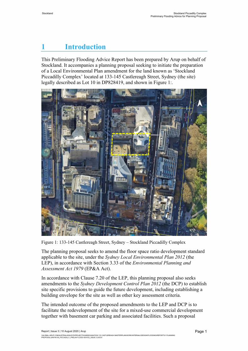
1 IntroductionThis Preliminary Flooding Advice Report has been prepared by Arup on behalf of Stockland. It accompanies a planning proposal seeking to initiate the preparation of a Local Environmental Plan amendment for the land known as ‘Stockland Piccadilly Complex’ located at 133-145 Castlereagh Street, Sydney (the site) legally described as Lot 10 in DP828419, and shown in Figure 1:.
Figure 1: 133-145 Castlereagh Street, Sydney – Stockland Piccadilly Complex
The planning proposal seeks to amend the floor space ratio development standard applicable to the site, under the Sydney Local Environmental Plan 2012 (the LEP), in accordance with Section 3.33 of the Environmental Planning and Assessment Act 1979 (EP&A Act).
In accordance with Clause 7.20 of the LEP, this planning proposal also seeks amendments to the Sydney Development Control Plan 2012 (the DCP) to establish site specific provisions to guide the future development, including establishing a building envelope for the site as well as other key assessment criteria.
The intended outcome of the proposed amendments to the LEP and DCP is to facilitate the redevelopment of the site for a mixed-use commercial development together with basement car parking and associated facilities. Such a proposal
Stockland Stockland Piccadilly ComplexPreliminary Flooding Advice for Planning Proposal
aligns with the draft Central Sydney Planning Strategy to facilitate additional commercial floor space capacity in Central Sydney while also delivering improved public domain outcomes. Such outcomes will include a northerly aligned direct through-site link between Pitt and Castlereagh Street and enhanced pedestrian amenity and activation at the ground plane.
1.1 Subject SiteThe site currently comprises three buildings known as the ‘Piccadilly Complex’ completed in 1991 which has been the subject of progressive improvements to upgrade selected elements within the building. The buildings currently occupying the site are detailed in Table 1.
Table 1: Description of existing buildings and improvements
Building Description
Piccadilly Court Comprises a 14-storey office building completed in 1975 and first refurbished in 1991 with frontage to Pitt Street.
Piccadilly Shopping Centre
Comprises a 2-storey retail building and the Wesley Mission facilities including the Wesley Church, Lyceum, Wesley Theatre and supporting office space predominately located at basement level. The Wesley Centre facilities comprise the following patron capacity: Theatre – 950 Lyceum – 277 Chapel – 534A footbridge over Pitt Street connects the building to 55 Market Street to the west.
Piccadilly Tower Comprises a 31-storey commercial building comprising office floor space and end of trip facilities and four basement levels of car parking accessed from Castlereagh Street. The building includes two lobby spaces, the main Castlereagh Street entrance and a smaller northern entrance to the through site link.A footbridge over Castlereagh Street connects the building to the Sheraton On the Park located to the east of the site.
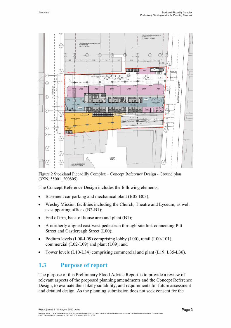
1.2 Concept Reference DesignTo demonstrate that the proposed building envelope is capable of accommodating a viable scheme, a Concept Reference Design accompanies the planning proposal within the Urban Design Study. The Concept Reference Design is indicative only and the final detailed design will be the subject of a competitive design process and detailed development application (DA) which will ultimately result in further refinement. The ground floor plan is shown in Figure 2.
Stockland Stockland Piccadilly ComplexPreliminary Flooding Advice for Planning Proposal
The Concept Reference Design includes the following elements:
Basement car parking and mechanical plant (B05-B03);
Wesley Mission facilities including the Church, Theatre and Lyceum, as well as supporting offices (B2-B1);
End of trip, back of house area and plant (B1);
A northerly aligned east-west pedestrian through-site link connecting Pitt Street and Castlereagh Street (L00);
Podium levels (L00-L09) comprising lobby (L00), retail (L00-L01), commercial (L02-L09) and plant (L09); and
Tower levels (L10-L34) comprising commercial and plant (L19, L35-L36).
1.3 Purpose of reportThe purpose of this Preliminary Flood Advice Report is to provide a review of relevant aspects of the proposed planning amendments and the Concept Reference Design, to evaluate their likely suitability, and requirements for future assessment and detailed design. As the planning submission does not seek consent for the
Stockland Stockland Piccadilly ComplexPreliminary Flooding Advice for Planning Proposal
specific development, a detailed quantitative assessment of the Concept Reference Design is not considered to be warranted at this stage.
A high-level review of flooding risk has been undertaken to identify the flooding constraints and likely flood planning implications for the proposed development. The flood advice is based on a desktop review of:
City Area Catchment Flood Study, Final Report, October 2014, BMT WBM
City Area Catchment Floodplain Risk Management Study, Final Report, September 2016, WMAwater
Interim Floodplain Management Policy, May 2014, City of Sydney Council
Sydney Development Control Plan 2012.
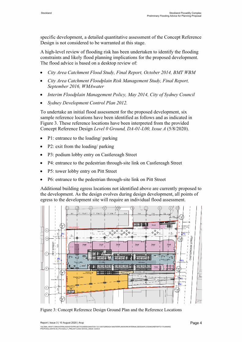
To undertake an initial flood assessment for the proposed development, six sample reference locations have been identified as follows and as indicated in Figure 3. These reference locations have been interpreted from the provided Concept Reference Design Level 0 Ground, DA-01-L00, Issue A (5/8/2020).
P1: entrance to the loading/ parking
P2: exit from the loading/ parking
P3: podium lobby entry on Castlereagh Street
P4: entrance to the pedestrian through-site link on Castlereagh Street
P5: tower lobby entry on Pitt Street
P6: entrance to the pedestrian through-site link on Pitt Street
Additional building egress locations not identified above are currently proposed to the development. As the design evolves during design development, all points of egress to the development site will require an individual flood assessment.
Figure 3: Concept Reference Design Ground Plan and the Reference Locations
Stockland Stockland Piccadilly ComplexPreliminary Flooding Advice for Planning Proposal
2.1 Previous studiesThe City Area Catchment Flood Study was completed by BMT WBM in October 2014 on behalf of the City of Sydney. A dynamic 1d/2d TUFLOW model was utilised using ‘the direct rainfall’ approach (also referred to as ‘rainfall-on-grid’ approach) in this study. This study defined the flood behaviour within the City Area catchment under the existing conditions in terms of the flood depths, flood levels, velocities and provisional hazard for a range of design events.
The City Area Catchment Floodplain Risk Management Plan was undertaken by WMAwater for the City of Sydney (WMAwater, September 2016). The existing model adopted in this study was based on the WBM’s model but incorporated minor refinements. It is referred to this report for flood information. The purpose of this study was to investigate the performance of a range of flood mitigation measures.
2.2 Review of the flood model resultsThis preliminary flood assessment was based on the existing model results in the City Area Catchment Floodplain Risk Management Study (WMAwater, September 2016). It is noted that the permission to use this WMAwater model for the current study has been granted by the City of Sydney.
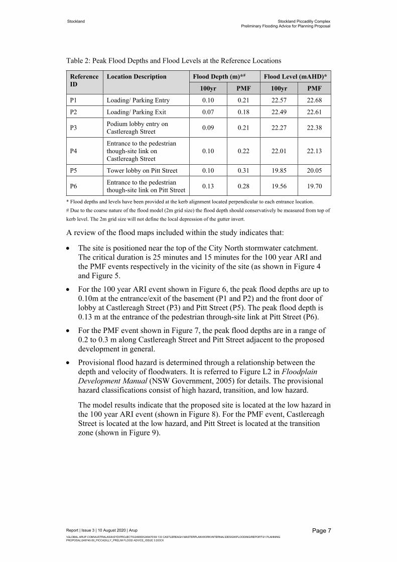
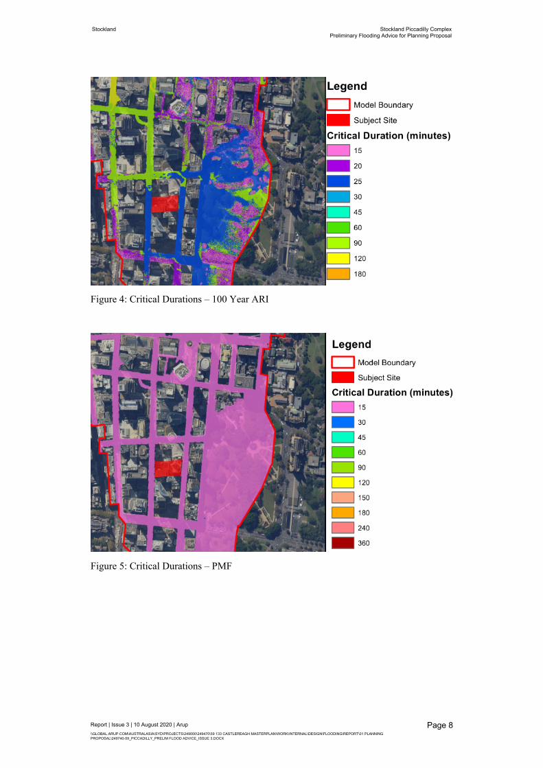
The flood maps for the 100 year average recurrence interval (ARI) and the probable maximum flood (PMF) events are listed in Table 1. The peak flood depths and flood levels at the reference locations are shown in Table 2. These locations are approximate only and have relied upon a manual overlay of the ground floor layout with the flood mapping.
Table 1: Flood information extracted from WMAwater Model
Figure Reference Flood Map Title
Figure 4 Critical Durations – 100 Year ARI
Figure 5 Critical Durations – PMF
Figure 6 Peak Flood Depths and Flood Levels – 100 Year ARI
Figure 7 Peak Flood Depths and Flood Levels – PMF
Figure 8 Provisional Hazard – 100 Year ARI
Figure 9 Provisional Hazard – PMF
Stockland Stockland Piccadilly ComplexPreliminary Flooding Advice for Planning Proposal
Table 2: Peak Flood Depths and Flood Levels at the Reference Locations
Flood Depth (m)*# Flood Level (mAHD)*Reference ID
Location Description
100yr PMF 100yr PMF
P1 Loading/ Parking Entry 0.10 0.21 22.57 22.68
P2 Loading/ Parking Exit 0.07 0.18 22.49 22.61
P3 Podium lobby entry on Castlereagh Street 0.09 0.21 22.27 22.38
P4Entrance to the pedestrian though-site link on Castlereagh Street
0.10 0.22 22.01 22.13
P5 Tower lobby on Pitt Street 0.10 0.31 19.85 20.05
P6 Entrance to the pedestrian though-site link on Pitt Street 0.13 0.28 19.56 19.70
* Flood depths and levels have been provided at the kerb alignment located perpendicular to each entrance location.# Due to the coarse nature of the flood model (2m grid size) the flood depth should conservatively be measured from top of kerb level. The 2m grid size will not define the local depression of the gutter invert.
A review of the flood maps included within the study indicates that:
The site is positioned near the top of the City North stormwater catchment. The critical duration is 25 minutes and 15 minutes for the 100 year ARI and the PMF events respectively in the vicinity of the site (as shown in Figure 4 and Figure 5.
For the 100 year ARI event shown in Figure 6, the peak flood depths are up to 0.10m at the entrance/exit of the basement (P1 and P2) and the front door of lobby at Castlereagh Street (P3) and Pitt Street (P5). The peak flood depth is 0.13 m at the entrance of the pedestrian through-site link at Pitt Street (P6).
For the PMF event shown in Figure 7, the peak flood depths are in a range of 0.2 to 0.3 m along Castlereagh Street and Pitt Street adjacent to the proposed development in general.
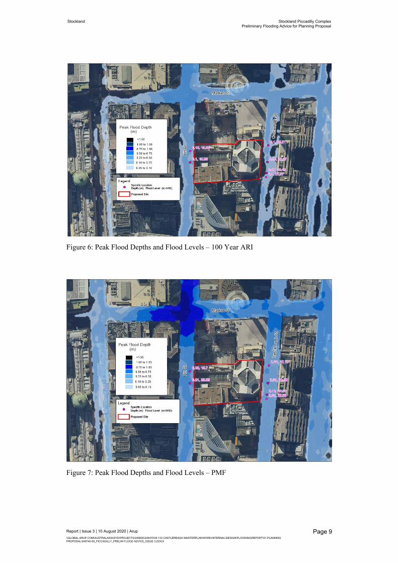
Provisional flood hazard is determined through a relationship between the depth and velocity of floodwaters. It is referred to Figure L2 in Floodplain Development Manual (NSW Government, 2005) for details. The provisional hazard classifications consist of high hazard, transition, and low hazard.
The model results indicate that the proposed site is located at the low hazard in the 100 year ARI event (shown in Figure 8). For the PMF event, Castlereagh Street is located at the low hazard, and Pitt Street is located at the transition zone (shown in Figure 9).
Stockland Stockland Piccadilly ComplexPreliminary Flooding Advice for Planning Proposal
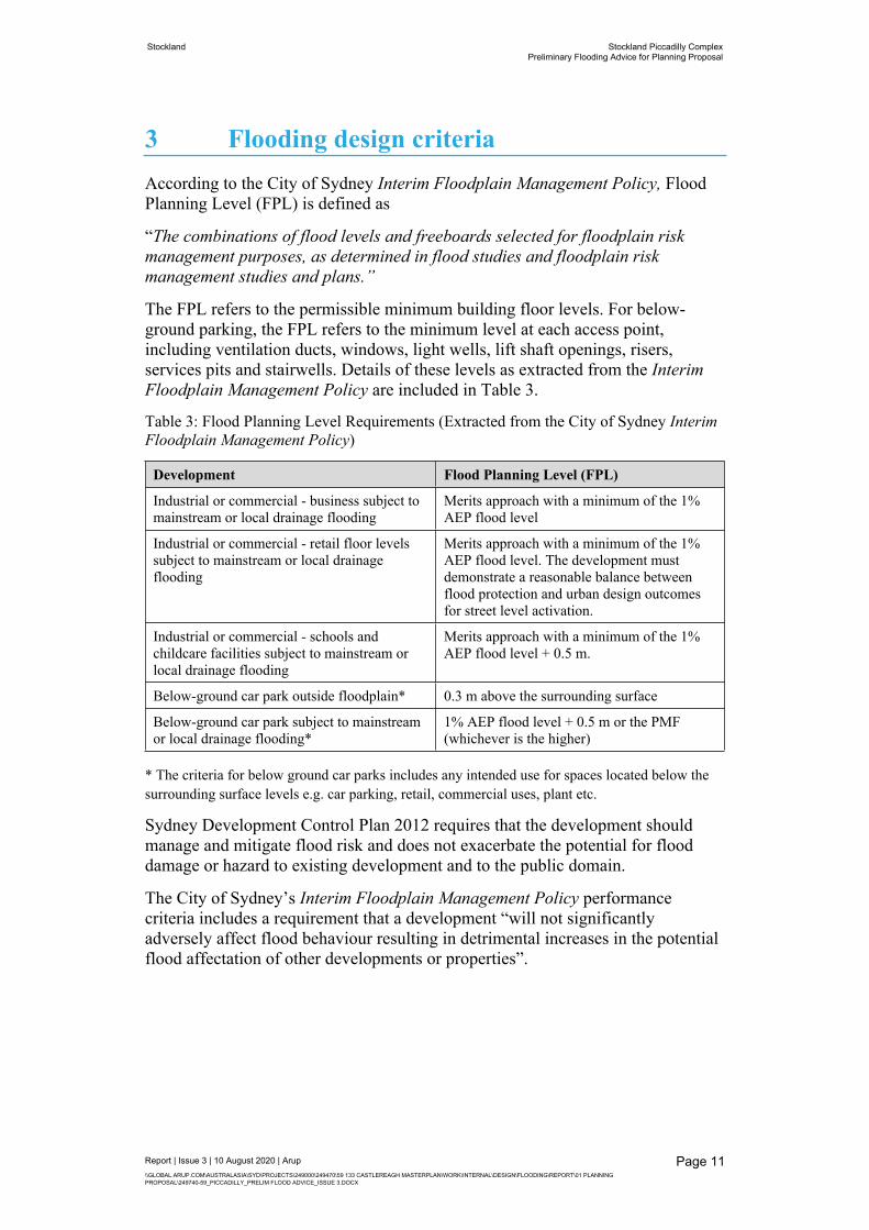
3 Flooding design criteriaAccording to the City of Sydney Interim Floodplain Management Policy, Flood Planning Level (FPL) is defined as
“The combinations of flood levels and freeboards selected for floodplain risk management purposes, as determined in flood studies and floodplain risk management studies and plans.”
The FPL refers to the permissible minimum building floor levels. For below-ground parking, the FPL refers to the minimum level at each access point, including ventilation ducts, windows, light wells, lift shaft openings, risers, services pits and stairwells. Details of these levels as extracted from the Interim Floodplain Management Policy are included in Table 3.
Table 3: Flood Planning Level Requirements (Extracted from the City of Sydney Interim Floodplain Management Policy)
Development Flood Planning Level (FPL)
Industrial or commercial - business subject to mainstream or local drainage flooding
Merits approach with a minimum of the 1% AEP flood level
Industrial or commercial - retail floor levels subject to mainstream or local drainage flooding
Merits approach with a minimum of the 1% AEP flood level. The development must demonstrate a reasonable balance between flood protection and urban design outcomes for street level activation.
Industrial or commercial - schools and childcare facilities subject to mainstream or local drainage flooding
Merits approach with a minimum of the 1% AEP flood level + 0.5 m.
Below-ground car park outside floodplain* 0.3 m above the surrounding surface
Below-ground car park subject to mainstream or local drainage flooding*
1% AEP flood level + 0.5 m or the PMF (whichever is the higher)
* The criteria for below ground car parks includes any intended use for spaces located below the surrounding surface levels e.g. car parking, retail, commercial uses, plant etc.
Sydney Development Control Plan 2012 requires that the development should manage and mitigate flood risk and does not exacerbate the potential for flood damage or hazard to existing development and to the public domain.
The City of Sydney’s Interim Floodplain Management Policy performance criteria includes a requirement that a development “will not significantly adversely affect flood behaviour resulting in detrimental increases in the potential flood affectation of other developments or properties”.
Stockland Stockland Piccadilly ComplexPreliminary Flooding Advice for Planning Proposal
4.1 Flood planning level requirementsThe City of Sydney’s Interim Floodplain Management Policy (May 2014) defines a floodplain as “the area of land which is subject to inundation by floods up to and including the probable maximum flood (PMF) event”. The WMAwater model results indicate that the peak flood depths for the PMF event are in a range of 0.2 to 0.3 m at Castlereagh Street and Pitt Street adjacent to the development, which would overtop the standard 150mm kerb height. Therefore, the proposed site should be considered as being subject to local drainage flooding, and the following flood requirements would apply in accordance with the required design criteria listed in Table 3.
The WMAwater flood model results indicate that the peak flood depths are up to 0.3 m for the PMF event on Castlereagh Street and Pitt Street adjacent to the development. Therefore the development types requiring a flood planning level criteria of “a minimum 1% AEP flood level + 0.5 m or the PMF (whichever is the higher)”, the governing flood planning level will be the 1% AEP flood level +0.5 m. This applies to developments including schools and childcare facilities and below-ground car parks and other basement infrastructure.The following identifies key considerations for the current Planning Proposal (Level 0 Ground, DA-01-L00, Issue A). Similar principles would apply to design development made to this proposal.
Loading/ Parking Entry and ExitThe 1% AEP flood level + 0.5 m will likely be the governing the crest level of the driveway to the basement loading/ parking. The WMAwater flood model indicates 1% AEP flood depths ranging 70-100 mm across the Castlereagh loading/ parking entry/ exit frontage. These depths are conservatively measured from top of kerb due to the coarse nature of the flood model. As such, the loading/ parking entry and exit will require grading within the public domain and internally to the site to achieve the FPL requirements which is in the order of 570-600 mm above adjacent top of kerb level. Based on similar commercial developments in the Sydney CBD, it can be a challenge to achieve this threshold level with a driveway crest while balancing urban design outcomes for street level activation and vehicle clearance requirements. FPL criteria and mitigation can be addressed through further consultation with Council during detailed DA stage. Options to address the FPL requirements include extended ramping to achieve flood protection through grading, a flood barrier (subject to Council approval) or a combination of both.
Ground Plane DevelopmentGround plane development areas identified in the current Planning Proposal (Level 0 Ground, DA-01-L00, Issue A) include:
Retail
Tower Lobby
Stockland Stockland Piccadilly ComplexPreliminary Flooding Advice for Planning Proposal
The ground plane development areas have a FPL based upon a merits approach with a minimum of the 1% AEP flood level. The WMAwater flood model indicates 1% AEP flood depths ranging 90-130 mm across the Castlereagh and Pitt Street frontages. These depths are conservatively measured from top of kerb due to the coarse nature of the flood model. As such, the ground plane development areas will require grading within the public domain and internally to the site to achieve the FPL requirements.
Basement Access and PenetrationsBasement access and penetrations identified in the current Planning Proposal (Level 0 Ground, DA-01-L00, Issue A) include:
Substation entry from Castlereagh Street
Escalator up to Level 1 retail (on the basis that the escalator pit base will typically require a drainage pit connected to sewer in the basement)
Lifts with connections to lower levels
Stairs with connections to lower levels
Escalators with connections to lower levels (eg escalator to Wesley functions)
Services connections to lower levels, including ventilation ducts, light wells, services risers, voids over lower levels etc.
The basement access and penetrations have a FPL of the greater of the 1% AEP + 0.5 m or the PMF flood level. Based upon the WMAwater flood model results, the governing FPL is the 1% AEP + 0.5 m. The WMAwater flood model indicates 1% AEP flood depths ranging 70-130 mm across the Castlereagh and Pitt Street frontages. These depths are conservatively measured from top of kerb due to the coarse nature of the flood model. As such, the basement access and penetrations will require grading within the public domain and internally to the site to achieve the FPL requirements which is in the order of 570-630 mm above adjacent top of kerb level. This may be achieved through grading/ ramping in both the public and private domain and steps at thresholds. However, it is recognised that achieving the FPL requirements whilst maintaining urban design outcomes for street level activation and accessible entry is likely to be a challenge. Flood barriers may be an option to achieve compliance, however this is subject to Council approval.
4.2 Flood affectationIt is anticipated that public domain works will be undertaken to the Castlereagh and Pitt Street site frontages. This may include adjustment to footpath alignment levels and grading. Any adjustment to existing levels would need to consider the performance requirement for the development which is:
the development should manage and mitigate flood risk and does not exacerbate the potential for flood damage or hazard to existing development and to the public domain; and
Stockland Stockland Piccadilly ComplexPreliminary Flooding Advice for Planning Proposal
a development “will not significantly adversely affect flood behaviour resulting in detrimental increases in the potential flood affectation of other developments or properties”.
During design development it will be necessary to coordinate the public domain design with the existing flooding to confirm that this requirement is met. This will also include incorporating detailed survey into the existing flood model to better define the existing site conditions.
Stockland Stockland Piccadilly ComplexPreliminary Flooding Advice for Planning Proposal
5 ConclusionThis preliminary flood assessment was based on the flood model results in the City Area Catchment Floodplain Risk Management Study. The model results are subject to assumptions and limitations associated with this model. Further hydraulic modelling is required to refine the existing flood levels, in particular incorporating detailed existing ground survey information for the site and surrounds and inclusion of more accurate representation of existing kerb lines within the model. Once the proposed design for the site has been developed, modelling will be undertaken to review flood performance, flood impact and to more accurately define the flood planning level requirements for the site.
The preliminary flood planning levels for the site have been identified based upon the existing WMAwater flood model. This information would be used to inform the future design development for the site. The requirements for the loading/ parking entry and exit and the basement access and penetrations (1% AEP flood level + 0.5 m) are particularly challenging within the constraints of maintaining urban design outcomes for street level activation and accessible site entry. This will require further consideration in design development to achieve compliance.