6
2
STRAIGHT BASELINES: TURKEY
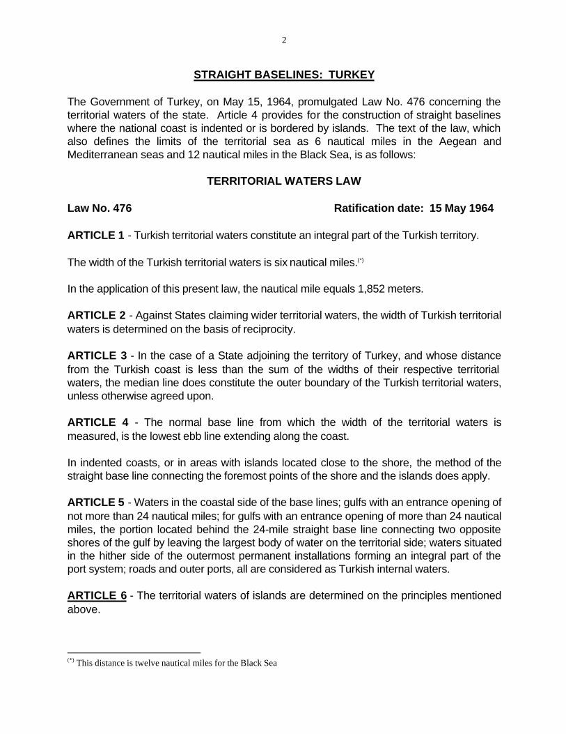
The Government of Turkey, on May 15, 1964, promulgated Law No. 476 concerning the territorial waters of the state. Article 4 provides for the construction of straight baselines where the national coast is indented or is bordered by islands. The text of the law, which also defines the limits of the territorial sea as 6 nautical miles in the Aegean and Mediterranean seas and 12 nautical miles in the Black Sea, is as follows:
TERRITORIAL WATERS LAW
Law No. 476 Ratification date: 15 May 1964
ARTICLE 1 - Turkish territorial waters constitute an integral part of the Turkish territory.
The width of the Turkish territorial waters is six nautical miles.(*)
In the application of this present law, the nautical mile equals 1,852 meters.
ARTICLE 2 - Against States claiming wider territorial waters, the width of Turkish territorial waters is determined on the basis of reciprocity.
ARTICLE 3 - In the case of a State adjoining the territory of Turkey, and whose distance from the Turkish coast is less than the sum of the widths of their respective territorial waters, the median line does constitute the outer boundary of the Turkish territorial waters, unless otherwise agreed upon.
ARTICLE 4 - The normal base line from which the width of the territorial waters is measured, is the lowest ebb line extending along the coast.
In indented coasts, or in areas with islands located close to the shore, the method of the straight base line connecting the foremost points of the shore and the islands does apply.
ARTICLE 5 - Waters in the coastal side of the base lines; gulfs with an entrance opening of not more than 24 nautical miles; for gulfs with an entrance opening of more than 24 nautical miles, the portion located behind the 24-mile straight base line connecting two opposite shores of the gulf by leaving the largest body of water on the territorial side; waters situated in the hither side of the outermost permanent installations forming an integral part of the port system; roads and outer ports, all are considered as Turkish internal waters.
ARTICLE 6 - The territorial waters of islands are determined on the principles mentioned above.
(*) This distance is twelve nautical miles for the Black Sea
3
ARTICLE 7 - Base lines used for the measuring of the width of territorial waters are shown on large-scale charts and released to interested parties.
ARTICLE 8 - In areas contiguous to Turkish territorial waters and extending up to 12 nautical miles from the base lines used for the measurement of territorial waters, the territorial waters regime is in force regarding fishing and exploitation of living resources.
ARTICLE 9 - The provisions of international treaties, conventions and agreements to which Turkey is a contracting Party remain valid.
The clauses of previous laws and regulations who may contradict the provisions of this present law are hereby void.
ARTICLE 10 - This law enters into force three months after its promulgation.
ARTICLE 11 - The provisions of this law are enforced by the Cabinet.
20 May 1964
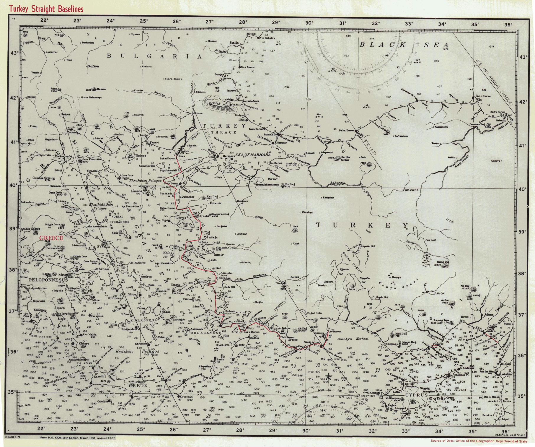
The straight baselines drawn by the Turkish Government are represented on the small-scale chart Turkiye, Karasulari esas ve Duz Hatlari Haritasi, 8003, 1:1,100,000, 17 May 1965 [Turkish Hydrographic Service]. The Government of Turkey has not signed the Geneva Convention on the Territorial Sea and Contiguous Zone.
Analysis and Summary
The coordinate values of the turning points for the straight baselines have not been published; moreover, the scale of the chart illustrating the lines is too small to permit an accurate and detailed analysis of the straight baseline segments. Several points, however, may be noted. No single segment is greater than 24 nautical miles in length although several are greater than 20 nautical miles. The longest, a bay closing line for Iskenderun bay, measures approximately 23.5 nautical miles in length. The bay is a juridical bay. The Turkish straight baseline system, in general, encloses a "deeply indented or cut into" coast rather than one "fringed with islands"; most Aegean islands are under Green sovereignty. In the north, however, the two principal Turkish islands, Imroz and Sozca ada, are enclosed within the system.
The straight baseline system appears to contain at least 119 individual segments. The total length o the system measures approximately 1,150 kilometers or 621 nautical miles. As stated, the longest baseline measures approximately 23.5 nautical miles. The average length is approximately 5.2 nautical miles.
Of particular interest, the Straits area is enclosed by the straight baselines. In fact, the closing line of the eastern end of the Bosphorus is the only segment in the Black Sea. Free

4
transit of the Straits is the subject, of course, of the Montreux Convention of July 20, 1936 (173 LNTS 213,219).