This section includes the strategic policies for economic prosperity, homes, transport, people and place and waste and minerals. These policies apply to the whole of Gateshead and Newcastle. Chapter 9 Economic Prosperity Chapter 10 Homes Chapter 11 Transport and Accessibility Chapter 12 People and Place Chapter 13 Waste and Minerals Section 3 Strategic Policies Strategic Policies
Transcript
This section includes the strategic policies for economic prosperity, homes, transport, people and place and waste and minerals. These policies apply to the whole of Gateshead and Newcastle.
Chapter 9 Economic Prosperity
Chapter 10 Homes
Chapter 11 Transport and Accessibility
Chapter 12 People and Place
Chapter 13 Waste and Minerals
Section 3 Strategic Policies
Stra
tegi
c Po
licie
s
9.1 The economic priorities for Gateshead and Newcastle are:
• To increase levels of growth, investment and productivity,
• To improve skills and provide businesses with the right support,
• To expand the role of the Urban Core as a focus for business, leisure and tourism, and as the regional retail centre, and
• To promote a strong network of district and local centres to meet the needs of all communities.
9.2 In order to achieve this, Gateshead and Newcastle must promote the growth of key sectors including globally competitive universities, a cluster of hospitals, a thriving knowledge economy driven through research and innovation, a strong financial and professional services sector, good road and public transport accessibility and access to a skilled labour force. The economic success of Gateshead and Newcastle is vital not just to our residents, but to the region as a whole.
9.3 Within this chapter are four policies to achieve economic prosperity: Policy CS5 Employment and Economic Growth Priorities, Policy CS6 Employment Land, Policy CS7 Retail and Centres and Policy CS8 Leisure, Culture and Tourism, which aim to provide a framework for the expansion and diversification of the economy.
Employment
9.4 Looking forward, economic growth is expected to be slow in the early part of the plan period following the recession. The medium to longer term economic outlook however is more positive, with growth expected to return. Bespoke population and household growth scenarios by St. Chad’s College at Durham University have informed the Plan. These are aligned with economic growth forecasts from Cambridge Econometrics that indicate an overall increase of around 22,000 jobs in Gateshead and Newcastle (around 8,000 in Gateshead, and 14,000 in Newcastle) from 2010-203022. These forecasts have informed future requirements for employment land reflected in our Employment Land Reviews (ELRs29) and Office Needs Study33. The 1PLAN17, which is the adopted Economic Masterplan for Gateshead and Newcastle Councils, sets out the expansion sectors and locations seen as critical to the conurbation’s economic future.
59
9. Economic Prosperity
Economic Prosperity
Section 3
9.5 Employment patterns are expected to change over time. In 2010, of the 299,00022 people who worked in Gateshead and Newcastle, around 45% (134,000)22 commuted from the rest of Tyne and Wear, and beyond. Our strategies to 2030 plan for an increase in Gateshead’s and Newcastle’s population, and in the size of the resident workforce compared with 2010 levels. The growth in employment is expected to be approximately 22,000 new jobs22. We will continue to rely on some in-commuting for a proportion of our skilled labour force, however, our housing policies will encourage more economically active households to live and work in Gateshead and Newcastle. It is anticipated that there will be a slight increase in commuting, although the proportion of jobs filled by in-commuters will decrease. It remains essential to grow employment opportunities in sustainable locations, supported by sustainable modes of transport.
Policy CS5 Employment and Economic Growth PrioritiesGateshead and Newcastle will play a major role in the economic growth of the North East. They will continue to develop a diverse economy with accessible employment and deliver significant increases in the number of businesses and jobs. This will be achieved by:
1. Ensuring a range of high quality economic development locations are available and attractive to the market.
2. Strengthening and clustering economic assets and promoting growth sectors including:
i. Financial, business and professional services in the Urban Core;
ii. Retail, leisure, health and tourism in the Urban Core;
iii. The knowledge based economy at Science Central, universities and further education institutes in the Urban Core;
iv. Marine and offshore engineering including renewables at Walker Riverside;
v. Advanced manufacturing and engineering at Team Valley;
vi. Creative media and digital at Ouseburn, Gateshead Quays and Baltic Business Quarter; and
vii. Distribution and logistics at Follingsby.
3. Supporting Newcastle International Airport as a key economic growth driver for the knowledge based economy and principal international gateway and focus of regional transport,
4. Significantly enhancing digital infrastructure,
5. Supporting entrepreneurship through the supply of a range and choice of premises,
6. Diversifying and expanding the rural economy by supporting local businesses and growth in leisure, culture and tourism, and
7. Attracting and supporting a skilled labour force and improving skills and access for local people to job opportunities including through targeted recruitment and training.
60
Econ
omic
Pro
sper
ity
9.6 Gateshead and Newcastle have undergone significant economic restructuring over the last 30 years. While some manufacturing sectors have declined over this period, between 1981 and 2010 employment in both Newcastle and Gateshead grew at a faster rate than the rest of the North East, supported by the growing service sectors. The economic potential combines both existing business sectors and new growth sectors including digital and creative, financial and business, biotechnology, engineering and environmental technologies.
9.7 Our universities and colleges support growth and provide centres for learning, research and business, as well as links to a global knowledge network. The planned growth of our further/higher educational institutions (including Newcastle University, Northumbria University, Newcastle College and Gateshead College) is encouraged and supported by both Councils. To remain competitive it will be essential that we utilise our research advantage, particularly in world-class sciences, to provide a catalyst for value-added enterprises focused on innovation and commercialisation. This will provide high-skilled and high-value employment, rooted in the local economy, which is less vulnerable to economic downturn.
9.8 Gateshead and Newcastle also accommodates clusters of engineering and environmental technologies at Team Valley and Walker Riverside, professional and financial services, creative industries and media in the Urban Core, and health care linked with our hospitals, Centre for Life and universities. These key sectors benefit from locating in close proximity to similar companies, suppliers and specialised service providers and research centres, promoting innovation through social interaction and economic specialisation.
9.9 The Plan also recognises the importance of transport and other infrastructure which supports economic activity. Newcastle International Airport is a major asset and provides easy access to surrounding areas. It will be important to maintain the attractiveness of our Employment Areas to businesses, through improvements to the road network, enhancement of green infrastructure improvements to public transport provision and the pedestrian and cycle networks, the refurbishment of existing premises, and, provision of complementary uses that meet local needs. To remain competitive in a changing economy and to support our growing knowledge and creative industries, access to high-speed broadband and digital infrastructure will be essential. This also plays an increasingly vital role in enhancing the provision and delivery of local community facilities and services.
61
Economic Prosperity
Section 3
9.10 A diverse range of accommodation and sites are available across Gateshead and Newcastle, from business start-up accommodation to headquarters for international companies. Small units and expansion sites are available within our established Employment Areas that can support existing local businesses. Sub-regional companies will be attracted from outside the local area for high quality premises and for accessible skilled labour, particularly in the Urban Core and Key Employment Areas. Large scale prestigious sites and premises are available for inward investment for national and international businesses, for instance around the airport. Local entrepreneurship will be supported by maintaining a stock of premises such as managed office workspace, suitable for business start-ups and small/medium sized enterprises (SMEs). The range of retail activity, tourism and leisure provision and cultural activity is wide, reflecting the role of the area as the regional centre, and some sectors will benefit from expansion.
9.11 The rural economy has seen reduced reliance on mining and intensive agriculture, and is now supported by a greater diversity of businesses such as forestry, leisure and tourism. To maintain a prosperous rural economy it will be important to enable a range of rural businesses to grow and promote the diversification of agricultural businesses, for instance through the conversion of farm buildings into small office premises and provision of accommodation in rural Employment Areas.
9.12 The benefits of a successful and growing economy must be shared. We need to improve access to employment, training and skills for communities experiencing high levels of deprivation. Poor skills can be a barrier to accessing employment, and so targeted recruitment, training agreements and partnership working with developers, for both the construction and occupation of developments, will help to maximise opportunities for local communities and businesses. Improving the portfolio of employment land and premises.
Improving the Portfolio of Employment Land and Premises
9.13 Providing a supply of land for business and industry is essential for achieving our vision of a flourishing economy. Our portfolio of economic land needs to provide a range and quantity of sites flexible enough to accommodate changing economic circumstances and respond to market demands, while supporting emerging sectors and entrepreneurship within sustainable locations.
62
Econ
omic
Pro
sper
ity
Policy CS6 Employment Land Employment land will be managed to meet our needs. This will be achieved by:
1. Ensuring a sufficient supply, range and choice of employment land is maintained for class B1, B2 and B8 uses. A minimum of 150 hectares of net developable employment land will be identified and allocated to meet the gross employment land requirements (including office floorspace).
2. Providing a minimum of 512,000 square metres (gross internal area) of office floor space including:
i. The Urban Core as the focus for the majority of office development,
ii. A limited amount of office development at Team Valley, Newcastle International Airport and Metrogreen, and
3. Requiring proposals over 200 square metres (net internal area) for office development in locations outside 2i and 2ii to undertake an impact and sequential assessment.
9.14 Gateshead and Newcastle will plan for sufficient employment land to meet the future needs of the economy and accommodate potential jobs growth in key economic sectors. The ELRs29 for both Gateshead and Newcastle identified the amount of office floorspace and industrial and warehousing land required over the plan period, to cater for the projected jobs growth. For employment uses, the studies identified the need to ensure provision to 2030 of a minimum of 150 hectares of developable land (70 hectares in Gateshead and 80 hectares in Newcastle) based on forecasted growth to meet the gross employment land requirements.
9.15 The ELRs29 identified a number of Employment Areas which should be retained and protected for employment use. These, in addition to the Key Employment Areas identified in Policies CS3 and CS4, are appropriate locations to develop and provide suitable accommodation for existing and new businesses. The Key Employment Areas, along with the Urban Core, are the focus of Gateshead and Newcastle’s industrial, distribution and office activities.
9.16 New office space requirements were assessed within the Office Needs Study33. This identified the need for a minimum of 512,000 square metres of office space to 2030. It is anticipated that 20% of the new office supply will be accommodated within Gateshead and 80% will be accommodated within Newcastle. Overall, Gateshead and Newcastle have an extensive supply of potential office sites which exceeds the projected demand for the plan period. However, this will ensure a choice of sites to meet a range of business needs/office segments and provide the flexibility for the plan to respond to changing economic circumstances.
9.17 The Urban Core is the priority location for new office floorspace and will accommodate around 75% of Gateshead and Newcastle’s office growth and support the continued evolution of this regionally significant office location. It provides a strategic and sustainable location of high- density employment, supporting vitality and the growth of ancillary services and facilities. By acting as an economic driver for the wider region and adding to the vibrancy of the Urban Core, these activities provide a desirable place for other businesses to locate, particularly knowledge-based sectors.
63
Economic Prosperity
Section 3
9.18 The Urban Core can cater for a range of business needs and office market segments from Grade A city centre space, to SME accommodation as well as some business park provision suitable for a large single use and inward investment. The Urban Core policies in Chapter 14 provide further detail on priority locations for office development.
9.19 Around 25% of office sites outside of the Urban Core will be taken forward in defined centres and at Metrogreen, Team Valley and Newcastle International Airport. These sites will accommodate business needs and office specifications that cannot be accommodated within the Urban Core, ensuring economic growth is not compromised by limited site availability. Outside these locations, proposals for office development of 200 square metres (NIA), or more must be accompanied by a sequential and impact assessment. This will need to demonstrate that investment is not being diverted from the Urban Core, the operational reasons for locating outside, specifying why it is not a suitable location and that the type of accommodation being proposed is appropriate to that location.
9.20 The Plan provides the necessary strategic and spatial policy direction for the future location of employment development, the implementation of which will be gauged through annual monitoring. More detailed policies and criteria, and specific allocations for employment and mixed-use development are set out in detailed Urban Core policies and will also be included in subsequent LDD’s. Proposals for non-employment uses which arise within the allocated Employment Areas will be considered against these relevant policies, together with the ELRs29.
Retail and Centres
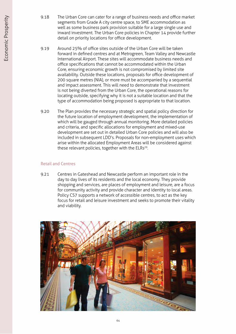
9.21 Centres in Gateshead and Newcastle perform an important role in the day to day lives of its residents and the local economy. They provide shopping and services, are places of employment and leisure, are a focus for community activity and provide character and identity to local areas. Policy CS7 supports a network of accessible centres, to act as the key focus for retail and leisure investment and seeks to promote their vitality and viability.
64
Econ
omic
Pro
sper
ity
Policy CS7 Retail and Centres The vitality and viability of centres in the retail hierarchy will be maintained and enhanced. These centres will form the focal point for uses, services and facilities serving the surrounding population. In addition to meeting local needs, the role of the retail sector in attracting visitors and contributing to the economy will be supported. This will be achieved by:
1. Protecting the vitality and viability of centres by encouraging a balance of retail and supporting uses which are appropriate in scale to the relative position of each centre in the retail hierarchy. The retail hierarchy is designated as:
i. Newcastle Retail Centre - is the regional retail centre and is the priority for strategic retail growth (this is defined in policy UC2).
ii. Gateshead Primary Shopping Area - the priority will be for retail-led mixed-use development.
iii. District Centres - provide key services including shopping, local services, leisure, public and community facilities;
In Newcastle (Figure 9.1a): 1) Adelaide Terrace, 2) Chillingham Road, 3) Denton Park, 4) Gosforth High Street, 5) Great Park, 6) Kingston Park, 7) Shields Road and 8) West Road.
2. Outside the retail hierarchy local community facilities and small shopping parades, including single shops, will be retained where they provide an important service to the local community and remain viable.
3. For retail proposals outside of the defined centres in the retail hierarchy:
i. Only permitting proposals where it can be demonstrated that there is not a sequentially preferable site in, or on the edge of, centres;
ii. Requiring an impact assessment in accordance with national planning guidance; and
iii. Considering impacts where there could be a significant adverse impact (regardless of development size) on a designated centre.
65
Economic Prosperity
Section 3
4. Applying 3 i-iii above to proposals for other main town centre uses outside the Urban Core, District and Local Centres.
5. The role of the Metrocentre, as an existing out-of-centre regional shopping destination, will be sustained and supported with proposals being assessed in line with national policy.
66
Econ
omic
Pro
sper
ity
N
Dinnington
Throckley
Great Park
Newburn
Blaydon
FellingPelaw
Birtley
Chopwell
Scotswood
Bensham
1
1
2
2
3
3
4
5
86
7
8
9
20
14
21 4024
2728 12
10
34 23
18 26
25
4541
39
17
36
31
29
1642
30
13
1944
11
15
3722
3543
11
10 18
21
2223
12
179
1915
20 13
16
Gosforth
Kingston Park
Denton
Kenton
Ryton
Whickham
Low Fell
Sunniside
Wrekenton14
High Spen
Northumberland
North Tyneside
South Tyneside
Sunderland
Durham
A1 North
A1 South
4
5
6
32
38
33
7
Urban Core
Neighbourhood Area
Rural and Village Area
A Road
River Tyne
Local Centre 9. Acorn Road 10. Arlington Avenue 11. Armstrong Road 12. Ashburton Road 13. Blakelaw (Moulton Place) 14. Brunton Park 15. Cedar Road 16. Chapel House 17. Church Walk 18. Clayton Road 19. Denton Square 20. Dinnington 21. Fawdon Park 22. Fenham Hall Drive 23. Four Lane Ends 24. Great North Road 25. Heaton Road 26. Jesmond Road 27. Kenton
28. Kenton Lane 29. Lemington 30. Newbiggin Hall 31. Newburn 32. Newton Place 33. Raby Cross 34. South Gosforth 35. Stanhope Street 36. Throckley 37. Two Ball Lonnen 38. Walkergate 39. Walker Road 40. Wansbeck Road 41. Welbeck Road 42. Westerhope 43. Westgate Road 44. Whickham View 45. Wretham Place
Newcastle Retail Centre
District Centre 1. Adelaide Terrace 2. Chillingham Road 3. Denton Park 4. Gosforth High Street 5. Great Park 6. Kingston Park 7. Shields Road 8. West Road
9.22 Gateshead and Newcastle benefits from a diverse network of City, Town, District and Local Centres with different characters and roles, which change over time. Many of these centres are performing strongly, however, certain centres are vulnerable, and need support to sustain them into the future.
9.23 The retail hierarchy has been defined, with centres being distributed across Gateshead and Newcastle. This recognises the roles that different centres play. In accordance with Policy CS1, the centres are identified as the most accessible locations in Gateshead and Newcastle, and therefore are well placed to be the focus for a range of developments. Policy CS8 complements Policy CS7 in that it encourages leisure, culture and tourist attractions to be focused within our centres proportionate to their scale. The boundaries of Gateshead and Newcastle’s Primary Shopping Areas in the Urban Core including the approach to primary frontage, are set out in Policies UC2, NC1 and GC1. The approach to other centres in the hierarchy, including those where there is a priority for improvement, will be set out in subsequent LDD’s.
9.24 In accordance with Policy CS2, major retail investment will be focused within our Urban Core to strengthen the role of Newcastle as the regional retail centre, and to underpin Gateshead’s regeneration objectives.
9.25 Newcastle is the regional destination for major retail and related uses including leisure, and there is significant potential for growth in these sectors. Newcastle’s Retail Centre is the priority for strategic retail and is defined as the Primary Shopping Area and the northern area of the East Pilgrim Street Key Site (Policy NC2) which once developed, will form part of an extended Primary Shopping Area. Newcastle has consistently been identified as the most sustainable location for retail growth and is the sequentially preferable area for major retail development.
9.26 The challenge for Gateshead Centre is to create a successful and sustainable centre which has a distinctive retail offer, which complements Newcastle Retail Centre and the Metrocentre. The centre is highly accessible and is the main administrative and service centre in Gateshead. However, it is less well positioned in retail terms, predominantly providing for local shopping needs, but with a low proportion of national multiples and a higher than average level of vacancy. There is capacity and a need for improvement within the Primary Shopping Area during the plan period. This includes the redeveloped Trinity Square, which provides a focus for retail provision, including new retail units and a new food store. There is capacity for additional development to come forward elsewhere in the Primary Shopping Area by 2030.
68
Econ
omic
Pro
sper
ity
9.27 The success of our centres is strongly influenced by the variety and choice of shops, services and other uses within them. In addition to Class A1 retail uses, a range of non-retail services within Classes A2, A3, A4 and A5 (e.g. banks, estate agents, bars, cafes and restaurants) will be considered provided these other uses would not harm the centres overall vitality and viability. These centres also provide the natural focus for community and leisure uses, including libraries, community centres, meeting places, crèches and nurseries, medical and health centres and leisure centres. The way these centres function and their vitality and viability will be managed by ensuring an appropriate mix of uses are retained, and by ensuring that new development does not harm these centres.
9.28 District Centres each perform a role and function which reflects the particular needs and character of their local community. The main role of District Centres is to allow access to a wide range of retail and related services, while Local Centres contain a smaller range of shops and services which support the daily needs of a smaller catchment area.
9.29 The need to identify and plan for further retail provision within the retail hierarchy is fundamental in delivering the Plan’s priorities for sustainable growth. In addition to the proposed designation of new centres at Great Park and Dinnington, and the proposed elevation to District Centre status of West Road, the capacity and need for further retail investment in some centres has been identified. By 2015 there will be a need for additional convenience goods floorspace in Gateshead in the form of a new supermarket in Birtley and another in Felling to provide new ‘anchor’ stores for these two centres.
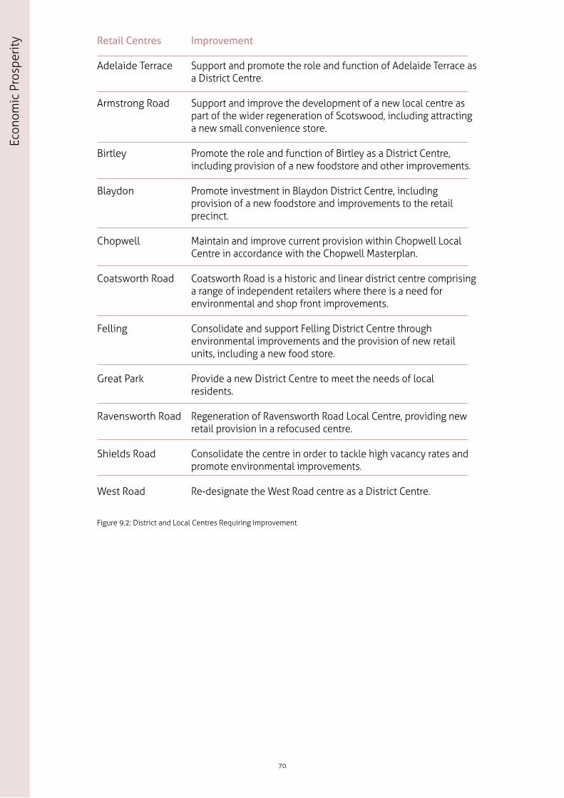
9.30 Figure 9.2 identifies those District and Local Centres where there is a need for improvement in the shopping provision and the shopping centre environment.
69
Economic Prosperity
Section 3
70
Econ
omic
Pro
sper
ity Retail Centres
Adelaide Terrace
Armstrong Road
Birtley
Blaydon
Chopwell
Coatsworth Road
Felling
Great Park
Ravensworth Road
Shields Road
West Road
Improvement
Support and promote the role and function of Adelaide Terrace as a District Centre.
Support and improve the development of a new local centre as part of the wider regeneration of Scotswood, including attracting a new small convenience store.
Promote the role and function of Birtley as a District Centre, including provision of a new foodstore and other improvements.
Promote investment in Blaydon District Centre, including provision of a new foodstore and improvements to the retail precinct.
Maintain and improve current provision within Chopwell Local Centre in accordance with the Chopwell Masterplan.
Coatsworth Road is a historic and linear district centre comprising a range of independent retailers where there is a need for environmental and shop front improvements.
Consolidate and support Felling District Centre through environmental improvements and the provision of new retail units, including a new food store.
Provide a new District Centre to meet the needs of local residents.
Regeneration of Ravensworth Road Local Centre, providing new retail provision in a refocused centre.
Consolidate the centre in order to tackle high vacancy rates and promote environmental improvements.
Re-designate the West Road centre as a District Centre.
Figure 9.2: District and Local Centres Requiring Improvement
9.31 While the overall approach is to focus as many services as possible within a centre, there are circumstances whereby some communities are reliant on isolated facilities which are important in meeting their day- to-day needs. These include small parades (including facilities which no longer meet the definition of a centre), corner shops and community facilities. Community facilities can include community centres, childcare facilities, cultural venues, village halls, religious meeting places, learning and training establishments, health and social care facilities, recreation, civic and administrative facilities. It may also include uses whose primary function is commercial but perform a social or community role, such as a café. The importance of retaining such facilities where these meet the day-to-day needs of the community is recognised in national policy. In the case where a change of use is proposed which would result in the loss of the only remaining facility in an area, a justification will be required including evidence of marketing for a similar use. This approach will be set out in more detail in subsequent LDD’s.
9.32 The vitality and viability of our centres is important and, in line with the NPPF, retail proposals outside existing centres in the retail hierarchy (see Policy CS7) will be required to submit sequential and impact assessments. For other main town centre uses, proposals outside the Urban Core, District and Local centres will also be required to submit sequential and impact assessments in line with the NPPF. Consideration of impacts for proposals which are below the NPPF threshold of 2,500 square metres may be required, as set out in the Validation of Planning Applications in Tyne and Wear checklist. This will be necessary where development could undermine the vitality and viability of a centre, or existing, committed and planned public and private investment in a centre or centres. The level of detail that applicants will be required to submit will be expected to be proportionate to the scale of the proposal concerned, and will be assessed in accordance with the impact criteria in the Planning Practice Guidance. In future, local thresholds for impact assessments will be established in LDD’s to reflect the scale and nature of centres in Gateshead and Newcastle respectively.
9.33 The Metrocentre complex in Gateshead also contributes to the strategic comparison and leisure provision within the region, attracting approximately 23 million visitors34 annually. As it is not allocated a place within the retail hierarchy, any proposals will be subject to an assessment in accordance with national policy. However, the contribution that development proposals could make to the economy and regeneration of the area will be given full consideration, alongside impact and sequential site assessments, when determining planning applications. In general terms there is a need to improve the external environment of the Metrocentre, including on-site pedestrian routes.
9.34 Retail provision elsewhere is focused on out-of-centre retail parks, including, for example, Retail World at Team Valley and Newcastle Shopping Park at Byker. Although such facilities perform a significant role in terms of comparison shopping, in retail policy terms they are not identified as centres and are therefore excluded from the retail hierarchy. Therefore, as with the Metrocentre, any proposals for additional provision will need to be assessed in accordance with national planning policy.
71
Economic Prosperity
Section 3
Leisure, Culture and Tourism
9.35 Gateshead and Newcastle are recognised as leisure, culture and tourist destinations boasting a variety of visitor attractions and a year-round events programme. The Newcastle Gateshead Initiative (NGI) is our joint leisure, culture and tourism marketing company, which has raised the national and international profile of Gateshead and Newcastle and the wider North East.
9.36 For the purposes of Policy CS8, leisure, culture and tourism uses are taken to include use classes C1 (e.g. hotels and guest houses), D1 (e.g. museums and art galleries), D2 (e.g. cinemas, music and concert halls, and gyms) and other Sui Generis uses including theatres and nightclubs.
9.37 Our leisure, culture and tourism attractions are spread across our 3 spatial character areas.
• People visit the Urban Core for shopping, for football at St James’ Park, for our city library, museums and galleries - including the recently refurbished Great North Museum, the BALTIC Centre for Contemporary Art, the Centre for Life, and Seven Stories the national centre for children’s books; for live music at the Sage Gateshead, Metro Radio Arena, O2 Academy and smaller venues such as the Cluny and Central Hotel; for the theatre - the Theatre Royal, Northern Stage, Journal Tyne Theatre, City Hall and Live Theatre; for films at the Gate and Tyneside Cinema.
• People visit our Neighbourhood Area for shopping; for eating and commercial leisure at the MetroCentre (including an IMAX cinema), in our retail parks and District Centres, for sport at Gateshead International Stadium, Kingston Park for rugby, and to golf at our many courses, and, to eat and drink particularly at Osborne Road, Jesmond and Low Fell.
• People visit our Rural and Village Area for individual attractions - including the Angel of the North, the Tanfield Railway and Gibside National Trust Estate, for sport at Newcastle Racecourse/High Gosforth Park, at Newburn for rowing and for cycling and golf at our many facilities.
9.38 As well as enjoying our specific attractions visitors come to Gateshead and Newcastle for business, our built heritage and for our evening offer. Business tourism is vital to the economy. Events such as conference meetings and exhibitions bring tourists to Gateshead and Newcastle all year round, generating £421 million for business events tourism in the North East region. In addition to this we are growing as a short break destination, supported by an expansion in hotel provision. Other significant events include The Great North Run an iconic feature of Gateshead and Newcastle’s cultural and sporting programme attracting tens of thousands of runners each year.
9.39 Leisure, culture and tourism are important to Gateshead and Newcastle’s economy and Policy CS8 aims to support our existing facilities and sets out our approach for future development. However, it should be read alongside other policies that address provision for more informal outdoor recreation and sports activities, including country parks, river- based sport and cycle routes for example. These include Policy CS18 Green Infrastructure and the Natural Environment and Policy CS13 Transport and Accessibility.
72
Econ
omic
Pro
sper
ity
9.40 If Gateshead and Newcastle are to remain competitive as a tourist destination, they need to continue to develop a range of accommodation, unique visitor attractions and experiences. The Councils recognise the importance of the culture, leisure and tourism economy and will continue to work with partners to support its growth. This includes our major sporting facilities which attract significant numbers of visitors to Gateshead and Newcastle, contributing to our economic prosperity.
Policy CS8 Leisure, Culture and TourismDevelopment which improves the range and quality of leisure, culture, and tourism facilities, including major sports venues and events, will be encouraged by: 1. Focusing leisure, cultural and tourist attractions in the Urban Core and at
accessible locations. 2. Supporting visitor attractions and accommodation in the Rural and
Village Area which are in accessible locations and do not undermine the character of the area.
9.41 Major new commercial facilities, including those connected with business tourism, will be directed to the Urban Core to strengthen its role and offer. It is important that our existing facilities including heritage assets such as Grainger Town are protected and enhanced. Provision elsewhere will be encouraged in accessible locations, including our District and Local Centres. These centres provide a good range of leisure and cultural facilities in sustainable locations which should continue to be supported and grow, providing that proposed facilities are of a suitable scale for the function of the centre in the retail hierarchy (CS7). This approach will ensure that a balance is provided between having local facilities to meet community needs, and directing major schemes to the most accessible locations. Outside the defined retail hierarchy, leisure provision at the Metrocentre also performs an important role.
9.42 There is a need to broaden the existing evening economy, increasing the range of facilities so that it is more socially inclusive, making our communities feel safe and welcoming. New facilities, as part of mixed- use schemes will help to attract visitors throughout the day and, where appropriate, support the evening economy.
9.43 There is potential to attract additional facilities and accommodation in the Rural and Village Area. This can help to facilitate rural diversification, sustain centres, and provide additional employment opportunities which contribute to the rural economy. Preference will be given to proposals which are appropriately located so as not to undermine the attractiveness of the area and which are accessible by sustainable modes of transport. The Derwent Valley in particular is identified as offering potential for additional accommodation and facilities, linked to existing attractions and wider infrastructure networks, including the national cycle routes which cross the area.
73
Economic Prosperity
Section 3
10.1 At the heart of the spatial strategy is the promotion of sustainable neighbourhoods, supporting Gateshead and Newcastle’s diverse population. Everyone should have the opportunity to live in a high quality, well designed home in sustainable, inclusive and mixed communities. To deliver a wide choice of homes, increase opportunities for home ownership, support job growth, minimise commuting and promote sustainable inclusive neighbourhoods, the Plan needs to provide sufficient homes. Policy CS1 sets out the need to provide 30,000 new homes by 2030.
10.2 While it is important to provide more homes within Gateshead and Newcastle, there is a need to consider housing quality and choice in terms of new and existing communities. This chapter sets out policies which seek to ensure that everyone has opportunity to access a decent home in a quality environment and which by:
• Contribute to making existing communities safe and sustainable places to live (CS9).
• Deliver new housing in Gateshead and Newcastle across the plan period (CS10).
• Provide an appropriate mix, type and tenure of housing in a range of locations and meet the needs of specific groups (CS11).
• Meet the needs of gypsies, travellers and travelling showpeople (CS12).
Existing Communities
10.3 In Gateshead and Newcastle there are a mix of neighbourhoods performing different roles and functions within the housing market. Many of these areas are successful and offer a good range of housing options, but some areas experience problems relating to poor quality housing and living environments. Our existing communities need to be sustained and improved to provide quality areas to live and work.
10.4 We already have some attractive areas of choice benefitting from good schools, good transport connections, quality green spaces, facilities and services and a range of housing types. However, this does not mean they cannot be improved. In other areas it is recognised that a holistic approach to regeneration is sometimes required which tackles any physical, social and/or environmental concerns to ensure their long term sustainability. The focus for investment will be on those areas which are characterised by an over dominance of particular housing types and a lack of tenure choice where residents have poor access to essential services and facilities. Within these areas there are many strengths including a strong sense of community and existing infrastructure. New development must complement strengths, retain existing residents and attract new ones.
74
10. Homes
Hom
es
10.5 This policy seeks to ensure that existing communities are sustainable for the future.
Policy CS9 Existing CommunitiesExisting communities will be sustainable places of quality and choice. This will be achieved by:
1. Maintaining a range of housing types and sizes throughout the plan area,
2. Maintaining and improving facilities, services and the local environment,
3. Bringing empty properties back into use, demolition of housing which is no longer viable or in demand, supporting programmes of improvement and renewal and the replacement of housing,
4. Preventing the loss of family homes, through sub-division, change of use or redevelopment, and
5. Preventing an over concentration of shared accommodation.
10.6 For communities to be attractive and sustainable, they must offer a variety of good quality homes in terms of types, sizes and tenures. They should also cater for a mix of different households, such as families with children, single person households, disabled and older people. A good quality environment, including adequate green infrastructure and access to facilities and services, is vital for sustainable communities. It is important to invest in existing homes and neighbourhoods to ensure they remain desirable areas. The Council will work with partners to ensure the environment of existing neighbourhoods is improved by addressing problems of poor housing, education, employment, transport, and public services.
10.7 In Gateshead and Newcastle approximately 4% of homes are empty. Our target is to reduce this to 3%. This is largely concentrated in the private sector stock and although housing vacancy rates have improved (notably in the social sector) this still remains an issue, particularly in our Opportunity Areas (Policy CS3). Gateshead and Newcastle are committed to working with partners including private landlords to bring empty properties back into use and ensure that they do not have a detrimental effect on otherwise sustainable, safe and pleasant communities. This will be achieved via a mixed approach of enforcement, engagement and encouraging new development and investment in homes for which there is demand, while replacing obsolete or poor quality housing.
10.8 Demolishing unpopular existing stock, replacing it with new homes to better address housing needs and aspirations, as identified in the Strategic Housing Market Assessment (SHMA)35, will further enhance and sustain communities. The demolition and replacement of low-demand poor quality housing will be supported as part of the wider regeneration programmes across Gateshead and Newcastle. The number of losses through demolition and change of use is expected to be approximately 4,500 losses during the plan period.
75
Hom
es
Section 3
10.9 Both councils are working in partnership with key delivery agencies including the Gateshead Housing Company, Your Homes Newcastle, registered housing providers and private landlords to improve homes across all tenures. Selective landlord licensing will be used where appropriate to manage and secure improvements to the private rented sector in areas with low demand and related social problems.
10.10 The Plan aims to retain and attract families to support economic growth. To achieve this, we need to ensure we prevent the loss of existing family homes which are attractive and popular. Therefore we will seek to resist conversions, sub-divisions, demolition and change of use proposals, where they would result in the loss of a family home.
10.11 Shared accommodation (including houses in multiple occupation) forms a very significant and valuable part of the private rented sector. It provides market housing to meet the needs of a variety of people whom, for one reason or another, either do not wish to or are unable to live in mainstream housing, in either the owner occupied or the social rented sector. However, high concentrations of shared accommodation can create problems in terms of environmental quality and residential amenity. Where this is the case Permitted Development Rights will be removed and policy introduced to assess proposals for further shared accommodation. Both councils are working closely with specialist providers and partners including the universities to meet demand for purpose built accommodation and ensure there is a choice of accommodation for all our residents.
Housing Delivery
10.12 On the basis of the projected population increase and changes in household size in Gateshead and Newcastle, there is a need to plan for approximately 30,000 new homes excluding purpose built student accommodation. It is expected that at least 2,000 units of purposed built student accommodation will also be built in the short term.
10.13 The Spatial Strategy (Policies CS1, 2, 3 and 4) set out how we will accommodate growth. Our strategy is to prioritise where possible new homes on brownfield land to support ongoing regeneration programmes and make efficient use of land and infrastructure. Locations for housing growth are illustrated in Figure 10.1. These sites along with smaller sites identified in our (SHLAAs)28 are expected to deliver an average of 1,500 new homes per annum.
76
Hom
es
77
Hom
es
Section 3
N
Northumberland
North Tyneside
South Tyneside
A1 North
A1 South
Dinnington
Throckley
Kibblesworth
Great Park
NewburnWalker Riverside
Highfield
Dunston and Teams Felling
Birtley
Chopwell
Benwell Scotswood
Elswick
BenshamSaltwell
Sunderland
Sunniside
Ryton
Kingston Park / Kenton Bank Foot
Newbiggin Hall
Hazlerigg / Wideopen
Upper Callerton
Middle Callerton
Lower Callerton
Crawcrook
High SpenDunston Hill
Byker
Durham
Metrogreen
Urban Core
Neighbourhood Area
Rural and Village Area
+ 1000 Homes
500 - 999 Homes
0 - 499 Homes
Existing Site for Gypsies, Travellers and Travelling Showpeople
Policy CS10 Delivering New HomesProvision of approximately 30,000 new homes (excluding purpose built student accommodation) will be built over the period April 2010 to March 2030 (on average 1,500 per annum); this equates to approximately 25,550 net additions to the housing stock. The broad distribution of new homes will be:
10.14 Due to the present state of the economy, the limited availability of housing finance, the necessity for demolition and a lack of deliverable housing sites until the Plan is adopted, it will take some time for development to reach the level required to accommodate needs. A five year land supply cannot be achieved without the development of Neighbourhood and Village Growth Areas. The allocation takes account of the requirement of the NPPF paragraph 47 to provide for an additional buffer of 20% if there is a record of persistent underperformance. Policy CS10 and Figure 10.2 reflect a realistic build profile, with the net build rate increasing from an average of 550 in 2013/14 to an average of 1,500 per annum by 2015 and being maintained at around this level over the remainder of the plan period.
10.15 The Councils have assessed the housing need and demand for Gateshead and Newcastle. Our evidence base highlights that a better range and choice of quality housing is needed to improve the housing offer. It is essential to plan to meet the needs of all parts of the community and to enable economic growth - the right homes in the right locations with the right facilities and services are important for attracting and retaining businesses. These needs include affordability for first time buyers or those who wish to move, for families and for our growing ageing population. We need to consider the design and layout of all new homes and the future needs of those groups who need specialist housing such as extra care homes. This Plan seeks to ensure that the right type of housing continues to be built and there is a variety of good quality homes in terms of type, size and tenure to cater for a mix of different households including families with children, single person households, older people and those with specific needs.
Policy CS11 Providing a Range and Choice of Housing Promoting lifetime neighbourhoods with a good range and choice of accommodation, services and facilities to meet varied and changing needs, will be achieved by:
1. Requiring 60% of new private housing across the plan area being suitable for and attractive to families, with a minimum target of 16,000 new homes to have three or more bedrooms.
2. Encouraging provision of Lifetime Homes and Wheelchair-Accessible Homes.
3. Increasing the choice of suitable accommodation for the elderly population and those with special needs including bungalows, sheltered accommodation and extra care accommodation.
4. Providing adequate space inside and outside of the home to meet the needs of residents.
5. Providing 15% affordable homes on all developments of 15 or more dwellings subject to development viability.
6. Focusing the provision of purpose built student accommodation within the Urban Core.
10.16 In order to rebalance the housing stock and retain and attract families in Gateshead and Newcastle, the Plan is requiring that 60% of new private homes are family homes (3-4 bedrooms). While there is projected to be a major increase in smaller households, for a variety of reasons, many of these households choose to occupy larger, more flexible properties. The supply in Gateshead and Newcastle is however limited by an historic housing stock which is distorted towards smaller property types and a low level of turnover of larger homes. Building new homes of the general mix outlined in Figure 10.3, will contribute to increasing the overall supply of larger homes and rebalance the housing stock.
79
Hom
es
Section 3
10.17 The SHMA35 identified that our current housing stock lacks larger family dwellings (particularly detached houses) and that more would need to be provided to support in-migration and reduce out-migration of family households. An issue of under-occupation of existing family housing stock (in the private and social sectors) was also identified with one trend being the tendency of elderly residents to remain in the family home after their children have left home. As recommended by the SHMA, the provision of more smaller properties for single people, couples and specialist accommodation for the elderly to offer real choice for those who would like to “downsize”. This, combined with the majority of new private homes (60%) being of 3 or more bedrooms, will help to meet the identified need for family homes across Gateshead and Newcastle. The delivery of new social sector housing should also be closely linked to the needs of older tenants and smaller households. Indeed making the best use of the housing stock is a key government objective.
10.18 The SHMA35 identifies a significant level of under-occupation in the social rented sector which contains over 9,000 three and four bedroom properties in Gateshead and Newcastle. It also identifies significant levels of under-occupation in the owner occupied and private rented stock. Many households remain in their properties even after their household size has reduced. The provision of good quality smaller accommodation in the social and market sector, particularly for the older population, will release existing larger homes and also help to reduce the affordable housing shortfall. We will work with partners and others on initiatives to help ‘free up’ the under-occupied stock.
Proportions of new private sector homes by number of bedrooms
1 Bed 2 Bed 3 Bed 4+ Bed
20% 20% 30% 30%
Figure 10.3 Proportions of New Private Sector Homes by Number of Bedrooms
10.19 Lifetime neighbourhoods provide all residents with the best possible chance of health, wellbeing and social inclusion regardless of age. They are sustainable communities that offer a good quality of life to all generations.
10.20 The creation of lifetime neighbourhoods (whether through retro- fitting in existing neighbourhoods or the development of new neighbourhoods) supports community cohesion by encouraging a diverse mix of accommodation helping residents to remain within their communities as their circumstances change. Wherever practicable, new housing will be encouraged to adopt principles of lifetime homes so as to be easily adaptable for everyone from young families to older people and people with disabilities. This will reduce the need for adaptations or for people to move home as their circumstances change.
80
Hom
es
10.21 Concerns have been raised that some new homes, and indeed some existing homes, do not have enough space for the modern family. For new development we are looking to ensure that the homes that are built are attractive to a wide range of residents by providing the right amount of both indoor and outdoor space, including storage, for their targeted market.
10.22 The Gateshead and Newcastle SHMA35 identifies a need for approximately 242 affordable housing units per year until 2018 (when a reassessment will be required) over and above the units that become available through stock turnover. Of these, it recommended that 65% should be for subsidised rent and 35% for subsidised home ownership. In view of the scale of need, provision of affordable units will be sought from all suitable developments of 15 or more homes but, not necessarily on-site. Each site will need to be assessed individually, with affordable housing provision being subject to wider planning economic viability, regeneration and sustainability considerations. This will require a flexible approach to specific site negotiation and looking at innovative ways to accelerate delivery. The total need for affordable housing is not expected to be met solely by new delivery through the planning system. A range of initiatives to make best use of the existing private rented and social stock will be pursued - tackling under-occupation by bringing vacant properties back into use, bringing social sector stock up to a modern standard and through the conversions of existing buildings. Further detail on a site by site basis will be provided in subsequent LDD’s.
81
Hom
es
Section 3
10.23 Gateshead and Newcastle are home to four major further education establishments. The two universities alone currently have around 40,000 full-time students, an increase of 15,000 since 2000/0136. By comparison, only around 2,650 bedrooms in purpose-built student accommodation were built over the period 2001-09 and so this has resulted in a significant increase in the numbers of students occupying homes in the private rented sector in areas such as Jesmond and Sandyford. Since 2007, in response to strong demand for student accommodation there has been a significant increase in the provision of new purpose-built student accommodation, and approximately 3,100 new bedrooms were delivered by 2013.
10.24 The universities envisage continued growth in student numbers (albeit at a slower rate) over the plan period but it is difficult to predict what the level of growth is likely to be or how this may translate into demand for student accommodation. However, there is a sizeable, flexible supply of land available within the Urban Core to accommodate different scenarios of future demand for purpose-built student housing. It is expected that a further 2,000 bedrooms will be constructed in the short term.
10.25 For the purposes of establishing the housing requirement in the Plan and the availability of housing land through the SHLAAs28 purpose-built student housing is specifically excluded from the demand and supply equation. This approach recognises that student housing is a niche market, with future growth rates uncertain, and accommodation can take many forms. This accommodation ranges from self-contained studio apartments and small to larger cluster flats and new halls of residence. The latter two do not constitute mainstream housing (which is defined as falling within Use Classes C3 and C4). Inclusion of student housing would alter housing outputs and land supply and detract from the key focus of intervention to facilitate increased delivery of conventional houses in order to stem net out-migration and in-commuting to surrounding districts. Demand for and supply of purpose-built student housing will be regularly reviewed in order to ascertain whether there is a need to consider policy intervention.
Gypsies, Travellers and Travelling Showpeople
10.26 Both Councils have a responsibility to assess and meet the needs of gypsies, travellers and travelling showpeople. Government policy emphasises the importance of assessing the accommodation needs of gypsies, travellers and travelling showpeople whilst taking a strategic approach to meeting needs that are identified. The updated Gateshead/Newcastle Gypsy and Traveller Accommodation Study estimates that between 2013 and 2018 there would be no need for provision in Newcastle and no need for additional pitches in Gateshead. Therefore, the existing site provided by Gateshead Council at Baltic Road has a capacity that meets the identified needs for the plan area.
10.27 The following policy has been assessed against the Government’s Planning Policy for Travellers Sites38 published in March 2012. It supports applications for new gypsy, traveller and travelling showpeople sites where they meet all the policy criteria. Improved provision in locations well related to existing settlements can benefit social inclusion, sustainable patterns of living and the delivery of relevant service, such as education and health care.
82
Hom
es
Policy CS12 Provision for Gypsies, Travellers and Travelling Showpeople The existing site for travelling groups will be retained. Where additional need is identified sites should be:
1. Well related and close to existing communities to encourage social inclusion and sustainable patterns of living and:
i. Avoid sites being over-concentrated in any one location or disproportionate in size to nearby communities,
ii. Be accessible to local services such as schools, health and community services,
iii. Avoid harmful impacts on nearby properties by noise and light, vehicle movements and other activities, and
iv. Avoid areas at high risk of flooding.
2. Safe, secure and be able to maintain visual amenity for occupiers. Additional landscaping may be necessary to maintain visual amenity and provide privacy for occupiers.
3. Capable of accommodating the proposed uses to acceptable standards and provide facilities appropriate to the type and size of the site. Sites should include:
i. Water supply, foul water drainage and recycling/waste management,
ii. Provision of play space for children,
iii. Safe vehicular access from the public highway and adequate provision for parking, turning and safe manoeuvring of vehicles within the site (taking account of site size and impact), and
iv. Areas of storage for show equipment for travelling showpeople.
4. Free from ground contamination.
83
Hom
es
Section 3
11.1 Transport and accessibility are fundamental to the delivery of the Plan’s spatial strategy. It is important that new development is located in the most sustainable locations and accessible by a choice of travel modes, including walking, cycling and public transport. This will help reduce the need for people to travel, minimise congestion, improve road safety and meet climate change reduction targets. This also links with the need to improve people’s health by creating more opportunities for people to walk or cycle rather than use the car.
11.2 Accessibility is the key relationship between transport and different land uses such as housing, employment and services. It defines how easily people can move between where they live and the places they need to get to in their daily lives.
11.3 Gateshead and Newcastle currently benefit from high levels of accessibility by all transport modes and in particular public transport. Traffic congestion is limited to a small number of key locations including the A1 and some of the main approaches to the Urban Core. It is important that development which generates growth is managed to ensure accessibility remains high and congestion low.
11.4 Newcastle is one of the UK’s most sustainable cities and has accolades to this effect., This is due in part to its excellent sustainable transport infrastructure and policies to encourage active travel.
11.5 This chapter deals with transport in and through Gateshead and Newcastle.
11.6 The Plan’s transport policies have been developed to:
• make Gateshead and Newcastle accessible to all,
• achieve a shift to more sustainable modes of travel including promoting alternative travel choices particularly along congested travel corridors,
• reduce carbon emissions from transport,
• enhance and protect the transport network to facilitate economic growth,
• improve the efficiency of our transport networks to manage demand, address capacity issues and get more from our existing infrastructure, and
• set out expectations in terms of development and how it will plan for the transport needs generated.
11.7 To improve the future for Gateshead and Newcastle local transport networks and wider strategic connections to the rest of the North East and beyond must remain fit for purpose and be improved where possible. The needs of all our communities in Gateshead and Newcastle need to be catered for and people must not be excluded from appropriate travel choices.
84
11. Transport and Accessibility
Tran
spor
t and
Acc
essi
bilit
y
11.8 By working closely with partners Gateshead and Newcastle have a good track record of justifying investment and securing funding to deliver large-scale transport infrastructure. However, the focus is also on managing existing infrastructure better. Improving and promoting accessibility by sustainable modes of transport is a means of achieving this and will also help to address climate change and reduce social exclusion, as well as helping to create a desirable place to live, work and visit.
11.9 Frequent use of sustainable modes of transport enhances the quality of life for residents. It can enable residents to access work and key services, contribute to addressing health and obesity issues, and reduce the negative impacts of local traffic. A sustainable, balanced transport system which promotes walking and cycling, while still acknowledging the need to cater for the private car, will help to reduce levels of traffic, congestion and pollution.
11.10 The continued development of sustainable transport networks will support the planned additional housing and will promote economic growth. It is likely that higher population density will lead to increased public transport capacity, as new demand is created for these services. This will particularly be the case if development is focused around locations with high levels of public transport accessibility.
85
Transport and Accessibility
Section 3
Policy CS13 TransportThe enhancement and delivery of an integrated transport network to support sustainable development and economic growth will be achieved by: 1. Promoting sustainable travel choices including: i. Improving equality of access to transport for everyone, ii. Protecting and enhancing pedestrian routes, cycle networks and Rights of
Way, iii. An integrated public transport network and interchanges, iv. Development of bus based park and ride facilities including at Lobley Hill,
Eighton Lodge and Follingsby, v. Metro re-invigoration and expansion of the Metro system in the longer
term, vi. Encouraging a change from sole occupancy car use to more sustainable
alternatives, and vii. The management of car parking locations, supply and pricing. 2. Improving the operation of the transport network and its wider connections by: i. Promoting and facilitating improvements to wider networks where it is
demonstrated that they have an acceptable impact on the local transport network and environment,
ii. Supporting the sustainable and efficient flow of passengers and freight via Newcastle International Airport, Newcastle Central Station, the Port of Tyne and High Speed Rail,
iii. Promoting the re-opening of regional heavy rail lines for passengers and freight, including the Leamside Line, and the Ashington, Blyth and Tyne Line,
iv. The creation of additional capacity on the Strategic Road Network, including the provision of an additional lane on the A1 in both directions from the A1/A19 Interchange at Seaton Burn to the Scotswood Road slip-‐roads, and between the southern extent of the Lobley Hill Major Scheme improvements at Coalhouse and the A1/A194(M) bifurcation at Birtley,
v. Undertaking an assessment of the need for additional cross-river capacity, vi. The development of Urban Traffic Management and Control (UTMC), vii. Reducing unnecessary traffic through, within and around the Urban Core,
and viii. Managing freight movement to minimise the impact on the network and
environment. 3. Ensuring development: i. Which generates significant movement is located where the use of
sustainable transport modes can be maximised, ii. Minimises car trips, promotes and enhances public transport and for major
development provides sustainable travel plans, iii. Connects safely to and mitigates the effects of development on the
existing transport networks, iv. Includes charging infrastructure for electric vehicles within major
developments, v. Incorporates 20 miles per hour zones and homezone principles, where
appropriate, vi. Provides cycle parking and supporting infrastructure, and vii. Provides for direct, safe, secure and continuous pedestrian and cycling
11.11 Figure 11 illustrates the transport improvements in the Plan that are supported by the Local Transport Plan for Tyne and Wear 2011-202139 and the emerging work of the North East Combined Authority.
11.12 The aim of the Plan is to create sustainable communities, centres and new developments where priority is given to sustainable modes of transport. The hierarchy of sustainable modes of transport is:
• Walking
• Cycling
• Public Transport (including taxis)
• Freight
• Car Traffic
11.13 There is a fundamental relationship between the location of development and how people choose to move around. It is a key part of the Plan’s transport strategy that the developments which generate the most trips should be located at the most accessible locations possible in terms of walking, cycling and public transport, and where they are not, that they provide improvements to the transport network to mitigate the impact of the trips generated.
11.14 Walking is a component of most journeys, and is an important form of transport in its own right. Routes that are well designed and safe encourage walking. This is central to other themes to enhance and create places that are people-friendly. Places that encourage public participation in leisure and recreation are those that are attractive and have strong economies. Walking and cycling contribute to improved health outcomes, through increasing personal exercise, improving wellbeing and happiness through interaction with the physical environment and other people. As walking and cycling become more prevalent carbon emissions will reduce.
11.15 The Councils will work with partners to create a strategic cycle network across the plan area that provides sustainable access to jobs and services. This network will be formed from a mixture of on-road lanes (sometimes mixed with other modes), shared-use paths, off-road routes and recommended routes through traffic-free areas. We will seek to further enhance a major north-south route across Gateshead and Newcastle and into Durham and Northumberland (the Great North Cycleway). This route will link all the major national and regional cycle routes in the area to the heart of Tyneside. We will also provide better links from our local network to the National Cycle Network and provide a new cross-river cycle and pedestrian link between Newburn and Blaydon. More cycle parking will be provided at key destinations.
11.16 The Councils have a statutory duty to manage the rights of way network and to publish a Rights of Way Improvement Plan39 (part of the Local Transport Plan). As well as fulfilling this duty, we will seek to ensure that development accommodates the network, or if this is not possible, to provide suitable replacement links.
88
Tran
spor
t and
Acc
essi
bilit
y
11.17 Excessive vehicle speeds are a deterrent to walking and cycling. Both Gateshead and Newcastle will continue to promote road safety and to introduce 20 mile per hour limits in residential streets and local centres. In addition, new developments will be encourage to be designed to homezone principles. Limiting vehicle speeds will be a key element of promoting sustainable travel choices.
11.18 Gateshead and Newcastle already has an extensive public transport network (Metro, bus, rail and taxi) that provides high levels of accessibility to services and opportunities across most of the area. However, there are some locations, notably towards the east and west (for example Walker, Crawcrook, Chopwell, Throckley, Newburn, Lemington) where accessibility is more limited. Working with partners the Councils will seek to address these inequalities, improve reliability, reduce journey times and enhance the journey quality for all passengers.
11.19 Buses play a significant role in improving accessibility and reducing the impact of car traffic. However, for bus services to be efficient, they need to be assigned greater priority so they are a viable alternative to car use. They also need to be better promoted and marketed so that more people are encouraged to use them. Both Gateshead and Newcastle have a good record of providing bus priority measures, and will further build on this by developing and implementing a programme of bus corridor improvements over the plan period. This will include:
• A692 Corridor
• Durham Road
• Felling Bypass
• Great North Road, Gosforth High Street
• West Road
11.20 We will also explore the ‘red route’ approach which includes parking restrictions and enforcement on our main bus corridors to improve bus efficiency. The Bus Strategy Delivery Project is being undertaken to examine delivery of key transport objectives which include maintaining and improving bus use, increasing network accessibility and delivering better value for money.
11.21 The emergence of new vehicles using alternative fuels will be a major feature of transport over the plan period and will contribute to tackling climate change. Gateshead and Newcastle are at the forefront of delivering investment in sustainable new technologies. Investment has been made in electric vehicles and the charging infrastructure across Gateshead and Newcastle. Local bus operators are currently investing in hybrid buses. The Councils will continue to support growth in this sector.
11.22 Given economic constraints, it is not feasible to provide bus services for all destinations, or at all times. Therefore, the Councils will work closely with taxi (hackney carriage and private hire vehicle) operators, and community transport groups, to ensure that the more flexible the services they provide are, the better they will be integrated into transport planning and information provision.
89
Transport and Accessibility
Section 3
11.23 Park and Ride facilities will play a role in reducing congestion. Facilities need to have convenient car access and be located on high- frequency transport corridors. Bus-based Park and Ride will be pursued primarily at the following locations:
• Eighton Lodge
• Follingsby
• Lobley Hill
11.24 Metro travel is greatly valued by passengers and plays a large part in the existing high levels of public transport accessibility in the area. The Tyne and Wear Metro is currently undergoing a significant programme of re-invigoration and this is expected to be the main focus of the Tyne and Wear Passenger Transport Executive’s (Nexus) investments over at least the early years of the plan period. It is important that Metro stations are considered safe, high quality places, and that they encourage seamless interchange with other modes of transport, including walking and cycling. However, the Metro system only serves a proportion of Gateshead and Newcastle and as the re- invigoration programme progresses the councils will work with Nexus to explore the potential extension of the network.
11.25 The councils will also support the North East Combined Authority, Nexus and bus operators in making public transport travel easier. For example, the introduction of smart ticketing on public transport will provide seamless integrated travel across the area.
11.26 Gateshead and Newcastle will develop a joint car parking strategy to manage demand. The strategy will seek to reduce long-stay commuter parking in centres. Short-stay parking for shoppers and visitors will be promoted. The introduction of car parking charges at retail centres will be sought where this can be achieved without threatening the vitality and viability of the centre. This will complement improvement of conditions for sustainable modes, including the expansion of Park and Ride.
11.27 A key theme of the plans transport policy is to improve the operation of existing air, rail and road transport networks that can help link the area nationally and internationally. Developing these networks to meet local demands and to strengthen strategic connections will be crucial to sustainable development in the plan area.
11.28 Strategic international, national and regional connections are very important in the way that Gateshead and Newcastle are seen by the rest of the world. Perceived isolation has an impact on the image of Gateshead and Newcastle as a place to live and to do business. Improvements on this scale will predominantly be delivered in partnership with outside agencies such as the Highways Agency or Network Rail as part of national programmes.
90
Tran
spor
t and
Acc
essi
bilit
y
11.29 The range of destinations served, and the facilities provided, by our main gateways at Newcastle International Airport, Newcastle Central Station and the Port of Tyne are crucial in developing perceptions of Gateshead and Newcastle as a place to live and to do business. These issues will largely fall outside the scope of this Plan, but Gateshead and Newcastle will continue to support and facilitate expansion as appropriate.
11.30 Connection of the North East to the proposed national High Speed Rail Network remains a priority in the long term. Gateshead and Newcastle as part of the North East Combined Authority will continue to promote the importance of any High Speed Rail Network being introduced in parallel on both the eastern and western sides of the country so as not to create economic disparity between regions. The councils and their partners will continue to lobby for and monitor the development of High Speed Rail through the plan period, defining and safeguarding potential routes and station locations as appropriate to ensure the network can be extended to the North East and on to Scotland.
11.31 Newcastle Central Station provides access to national, regional and local rail services. The councils and their partners will continue to improve access to these services by further developing interchange facilities, implementing public realm improvements, introducing better crossing facilities and developing a southern access route. Policy NC1 sets out specific proposals for the Central Gateway projects, which will improve Central Station and the surrounding area. The Councils and their partners will also work with regional partners, East Coast and Network Rail, to support improvements to the East Coast Main Line. The importance of continued investment in the existing rail network in the short to medium term is recognised, to ensure forecast growth on this important strategic connection is addressed. Similarly we will press for improvements to the local rail network by supporting the re-instatement of the Leamside Line, and the Ashington, Blyth and Tyne line as sustainable connections to and from the Urban Core.
11.32 The Strategic Road Network serving the area (A1, A69, A194(M) and A696) is essential for connectivity which will help secure economic growth and prosperity for Gateshead and Newcastle. The councils will work with the Highways Agency to facilitate enhancements to these strategic corridors, giving better access to other major towns and cities and to international gateways.
11.33 While supporting improvements across the Strategic Road Network is important, tackling congestion on the A1 is our priority. As part of the Newcastle City Deal (July 2012)16, it was agreed that the Department of Transport, the Highways Agency, the councils and other local partners would develop an investment programme to reduce congestion on the A1 Western Bypass, and finalise a business case for an improvement scheme at Lobley Hill. The funding for this scheme is now in place to allow completion by 2017. The Highways Agency has also now published its wider route based strategy for this section of the A1 which sets out a number of possible further interventions, including schemes to provide additional capacity, reduce speed limits and introduce traffic signal controlled access to the route. Further work by the Highways Agency has suggested that the A1 is likely to require an additional lane of capacity in both directions along much of this route. These additional lanes are likely to be needed from Seaton Burn to the Scotswood Road north-facing slip-roads, and then from the southern extent of the Lobley Hill Major Scheme to the A1/A194(M) bifurcation at Birtley.
91
Transport and Accessibility
Section 3
11.34 The promotion of sustainable modes of transport and the delivery of infrastructure improvements will be supported by further development of the area’s intelligent transport system - Urban Traffic Management Control (UTMC). The introduction of UTMC will make best use of the existing road network for all modes of transport and provide valuable information to those who seek to move around the Urban Core. The system will manage traffic flows, car parking and priority for sustainable modes of transport giving valuable information to the travelling public, enabling them to make more informed travel choices.
11.35 Movement of goods is fundamental to an effective economy. While the councils will seek to promote and facilitate the expansion of rail and sea freight, it must also be recognised that the majority of freight movements will remain on-road and that safe and efficient movement for goods vehicles must be provided. Both Gateshead and Newcastle are members of the Tyne and Wear Freight Quality Partnership and will continue to fully support its work in improving freight mapping, signage, driver information, freight exchange programmes and environmental fleet recognition.
11.36 The strength of Gateshead and Newcastle as the main centres of employment within the regional economy means that there is already an influx of commuters from neighbouring authorities. The balanced approach to managing and developing networks, including intelligent transport systems and the bus corridor and Park and Ride proposals will help to accommodate movements and minimise their impact. Neighbouring authorities will be expected to contribute to this approach, where appropriate.
11.37 Assessment of the traffic impacts of our growth aspirations highlighted a number of potential concerns where more detailed investigation may be required including Main Radial Corridors, Wrekenton, Team Valley, Lamesley, Whickham, Blue House Roundabout, Cowgate and Haddricks Mill. A number of potential mitigation schemes have been identified and are included in the Infrastructure Delivery Plan (IDP).
11.38 Some strategic infrastructure may not continue to serve the network as it currently does and alternative infrastructure may need to be provided during the plan period. One example of this is the High Level Bridge which currently carries public transport south out of Newcastle into Gateshead. It is possible that the councils will need to provide additional crossing capacity on the river during the lifetime of the Plan to mitigate against reductions in capacity and to support our growth aspirations. Gateshead and Newcastle will examine new crossings to the east and the west. Where these are found to be beneficial the councils will prepare funding bids and seek other sources of funding to provide them and work with the Combined Authority to prioritise future investment in these infrastructure projects as they develop.
92
Tran
spor
t and
Acc
essi
bilit
y
11.39 The Urban Core chapter sets out how to manage transport networks to and through the Urban Core. It also sets out how to improve the local environment, public realm and accessibility and reduce non-essential traffic.
11.40 Traffic that passes through the Urban Core contributes significantly to congestion but little to its vitality. While working towards the reduction of this traffic, we must also recognise that although some of the main traffic routes through the Urban Core act as barriers to other forms of travel, particularly walking, some traffic is also necessary to bring vitality and growth. We will seek to manage routes by reducing traffic speeds, improving crossings and improving the public realm.
11.41 All developments have an impact on the transport network. In order to manage the network effectively, take account of road safety and support sustainable travel development must ensure that it minimises car trips, supports sustainable travel alternatives, facilitates all modes and mitigates its impacts on the highway network. The need for new routes through the Green Belt will be assessed as part of the masterplanning process for housing and employment sites.
11.42 The potential impacts of development will be evaluated through Transport Assessments or Statements primarily. The councils will implement best practice guidance to mitigate any adverse impacts. In addressing potential impacts, car parking at developments will be managed, and robust and measurable travel plans will be required to minimise the number of car trips attracted and generated.
11.43 As part of the planning application process, developers will be expected
to address any identifiable impacts on, or barriers to, sustainable travel. This will be done by improving linkages to development from surrounding areas (particularly for pedestrians and cyclists), improving connections between homes and jobs, and by incorporating best practice to decrease the mode share of the private car.
11.44 Developers will be required to complement the Councils’ introduction of charging points for electric vehicles by incorporating them as a minimum in major developments, and by the introduction of 20 miles per hour zones in all residential areas as well as encouraging the adoption of homezone principles.
11.45 Pedestrian and cycle access to and through new developments must be safe, direct and usable. Layouts of new developments are expected to facilitate an increase in cycling, together with an emphasis on creating walkable neighbourhoods, where facilities and services can easily be accessed on foot.
93
Transport and Accessibility
Section 3
12.1 People and place is a cross cutting theme in the Plan covering important aspects of Gateshead and Newcastle. Attractive environments and a high quality of place contributes to the wellbeing of residents. In accommodating growth and new development, it is important that this quality is not compromised. The key aspects addressed in the people and place chapter are enhancing the integrity of our natural environment, heritage assets and green infrastructure, together with a sustainable approach to tackling health, flood risk and climate change issues.
12.2 The following chapter therefore includes policies on wellbeing and health (Policy CS14), place-making (Policy CS15), climate change (Policy CS16), flood risk and water management (Policy CS17), green infrastructure and natural environment (Policy CS18) and Green Belt (Policy CS19).
Wellbeing and health
12.3 Across Gateshead and Newcastle there are marked differences in physical and mental health and life expectancy between the most deprived and most affluent neighbourhoods. Evidence shows that health inequalities are linked to social and economic issues and that action is required across the wider social determinants of health. The wider determinants of health are closely linked to the quality of life enjoyed by residents. This includes having the opportunity to earn a reasonable wage, live an active lifestyle and have access to local employment opportunities, healthy housing, open space, cultural and community facilities, healthy food and care and health facilities. Development has the ability to positively influence wellbeing and health, and spatial planning aims to consider and positively influence the determinants of health.
CS14 Wellbeing and HealthThe wellbeing and health of communities will be maintained and improved by:
1. Requiring development to contribute to creating an age friendly, healthy and equitable living environment through:
i. Creating an inclusive built and natural environment,
ii. Promoting and facilitating active and healthy lifestyles,
iii. Preventing negative impacts on residential amenity and wider public safety from noise, ground instability, ground and water contamination, vibration and air quality,
iv. Providing good access for all to health and social care facilities, and
v. Promoting access for all to green spaces, sports facilities, play and recreation opportunities.
2. Promoting allotments and gardens for exercise, recreation and for healthy locally produced food.
3. Controlling the location of, and access to, unhealthy eating outlets.
94
12. People and Place
Peop
le a
nd P
lace
12.4 Wellbeing, health and equality are cross-cutting themes, and Policy CS14 should therefore be read alongside other policies that address the wider determinants of health, wellbeing and equity. These include access to community facilities, encouraging walking and cycling, providing employment opportunities, creating sustainable communities, ensuring access to green and open space and placemaking. More detailed policies and standards relating to these themes will be set out in subsequent LDD’s.
12.5 With the increasing proportions of older people and greater diversity in our communities there will also be challenges ahead to make sure that the needs of all are met in a fair and inclusive way. The built environment can contribute to this through a considered approach to the location, design and accessibility of development. This will ensure that residents have equal access to opportunities in employment, housing and health, and that opportunities for social interaction in a safe environment are provided.
12.6 By ensuring an equitable distribution of services and amenities, the Plan can help reduce health inequalities and encourage healthy lifestyle choices. The location of development can help to sustain neighbourhoods by encouraging physical activity and the provision of accessible facilities to meet the needs of our diverse communities. Until more detailed requirements are set out in subsequent LDD’s major developments will need to demonstrate how this has been achieved in their Design and Access Statement.
12.7 Locations for development will be assessed, in terms of compatibility and amenity, taking into account the potential risks from non-compatible neighbouring uses and environmental constraints, including potential contamination, ground instability and poor air quality. Public safety and stability issues associated with mining legacy will also need to be addressed.
12.8 The Councils will continue to work with partners, including health providers, to deliver and protect an integrated network of appropriate health facilities in sustainable, accessible locations, responsive to the diverse needs of residents.
12.9 The provision of open space, sport and recreation facilities is an important factor in the health and wellbeing of communities. Areas of open space that are valued by residents provide an important community function, and can make a significant contribution to quality of life. The accessibility, quality and quantity of open space, sport and recreation facilities will be addressed and monitored through the Local Plan.
95
People and Place
Section 3
12.10 A network of allotments and private gardens, in addition to providing green space in an area, also provide opportunities for outdoor recreation, contributing to physical and mental wellbeing. Allotments provide a place for people to interact, and to produce healthy locally grown food, which can help to improve the diet of residents. An important contributing factor to poor diet and health in certain parts of Gateshead and Newcastle is the distribution and access to unhealthy eating outlets. In certain locations there is an issue where such uses cluster together, reinforcing the ease of access to unhealthy foods. Consideration will therefore be given to controlling the proliferation of and therefore access to, such uses. This will be considered further in subsequent LDD’s and/or Supplementary Planning Documents (SPDs).
Place-making
12.11 The quality of our lives is determined, in large part, by the surrounding environment. Quality of place has an important role in attracting and retaining residents, visitors and businesses into Gateshead and Newcastle and contributing to the overall quality of life. Development should add to what is locally distinctive or create a new sense of place where this is needed.
12.12 The Plan seeks to provide a sustainable and high quality environment for future generations, providing places that people are attracted to and wish to stay in. The design and condition of the built environment also has a major influence on levels of crime, health, inclusion, community cohesion and wellbeing.
12.13 Development needs to renew and improve the public realm, its built form, its environmental performance and the mitigation of climate change. The right development in the right location, moving away from standard solutions can be used to enhance heritage assets, townscape characteristics and local distinctiveness. The historic and natural environment, the townscape that we have inherited, and the enhancement of these, should be a starting point for consideration of any development.
12.14 The following policy plays a key part in achieving good place-making by setting out the approach to conserving and enhancing valued places and heritage, and by ensuring that development is of a high standard, improving and reflecting its local area.
96
Peop
le a
nd P
lace
Policy CS15 Place-Making Development will contribute to good place-making through the delivery of high quality and sustainable design, and the conservation and enhancement of the historic environment. This will be achieved by:
1. Development being required to:
i. Respond positively to local distinctiveness and character,
ii. Create safe and inclusive environments,
iii. Ensure connectivity, accessibility and legibility,
iv. Respect and enhance significant views and the setting of heritage assets,
v. Respond to the unique character and importance of the River Tyne, its tributaries and its setting,
vi. Respond positively to opportunities to introduce public art, and
vii. Respond to local design and conservation guidance.
2. Taking a proactive approach to sustaining the historic environment in a manner appropriate to the significance of the relevant heritage asset and requiring development to support and safeguard the historic environment by:
i. Promoting the use, enjoyment and understanding of the historic environment,
ii. Positively responding to those heritage assets which are at risk, and not leaving heritage assets at risk, or vulnerable to risk, and
iii. Where appropriate positively adapting heritage assets to ensure the continued contribution to quality of place.
12.15 High quality design is a key element of good place-making and in enhancing the positive features of Gateshead and Newcastle. The two Councils have detailed development guidance available for applicants, which expand on these general principles. In addition, policies in chapters 16 and 17 set out more detailed design intentions and expectations for Sub-Areas and sites. Specific policies will also be included in subsequent LDD’s.
12.16 Successful place-making requires an understanding and respect for an area’s unique built, natural, cultural and socio-economic context. The distinctive character and sense of place of many areas within Gateshead and Newcastle are the result of their setting, development and the underlying land form. The Tyne river crossings, the various river valleys, the dramatic topography, natural landscape and the close proximity of rural and urban landscapes provide some of the most defining characteristics of Gateshead and Newcastle. The relationship of development to the topography and landscape is very important, and can significantly influence the outcome of development and add to the quality of place. Views across and within the plan area can be a significant and distinctive feature of the whole conurbation. They need to be respected and maintained and it is therefore essential that development proposals take into consideration, and respond positively to existing views.
97
People and Place
Section 3
12.17 Public art, imaginatively and sensitively used, can help to enhance and celebrate the sense of place, as well as add distinctiveness and encourage civic pride. It can also make way finding easier.
12.18 Gateshead and Newcastle have a high concentration of heritage assets. There are 30 Scheduled Ancient Monuments including Hadrian’s Wall (also a World Heritage Site), the Castle Keep and Dunston Staithes. Over 4,000 buildings are listed18, and it is notable that the number of Grade I listed buildings in the Newcastle Central Conservation Area is substantially higher than the national average. There are 34 Conservation Areas, 10 Registered Parks and Gardens, and a Registered Battlefield, at Newburn Ford. Both Councils have adopted Local Lists of protection, totalling over 500 buildings, monuments, parks and gardens. These are key assets which the authorities will seek to protect for the future and which provide further opportunities for enhancement. The manner in which the area has developed historically underpins the unique characteristics, qualities and identity of Gateshead and Newcastle. This is a positive foundation on which to build quality, ensuring distinctiveness and providing a strong sense of place for local people. The quality of development is generally improved when it is informed by local characteristics, including the historic environment.
98
Peop
le a
nd P
lace
12.19 The rich historic environment in Gateshead and Newcastle has relatively few heritage assets ‘at risk’, when considered as a percentage of the total. However, pressures for development, lack of investment and inconsiderate development could result in additional assets becoming at risk. There is a need to ensure that groups or types of heritage assets most at risk are targeted in planning or regeneration proposals. The underlying principle is to reconcile the need for growth and the viability of development with the need to conserve the historic environment and protect local character.
12.20 The re-use of heritage assets can positively assist with the delivery of the wider vision set out in this strategy. Encouraging access and promoting the understanding of the historic environment will ensure that people can get the most out of Gateshead and Newcastle’s heritage and that its tourism potential is enhanced.
Climate change
12.21 Climate change represents a major challenge to our way of life, and alongside the need for development to meet today’s needs comes a responsibility to future generations. The Plan promotes sustainable development, including urban patterns that use resources and land more efficiently, underpinned by a more sustainable economy. Buildings will need to use resources more efficiently and reduce their energy consumption. This approach will reduce our ecological footprint and improve the long-term social, economic and environmental health of Gateshead and Newcastle.
12.22 The Climate Change Act 200840 requires that the UK reduces its greenhouse gas emissions by at least 80% (from the 1990 baseline) by 2050. Both Gateshead and Newcastle have signed up to the Covenant of Mayors27 commitments on sustainable energy. This is a commitment to go beyond a 20% reduction by 2020.
12.23 Gateshead and Newcastle recognise they have a role to play in mitigating and adapting to climate change. Both Councils have ambitious targets in their Climate Change Strategies to achieve reduced CO2 emissions from existing houses. This policy seeks to encourage the development of low carbon and renewable energy solutions appropriate to the scale and circumstance of the development.
99
People and Place
Section 3
Policy CS16 Climate ChangeDevelopment will be sustainable, able to function effectively in a changing climate and address impacts on climate change emissions. Development will be required to:
1. Use a good standard of building fabric, passive design, and landscaping measures to minimise energy demand,
2. Be flexible from the outset to allow adaptation to alternative uses,
3. Deliver a good level of sustainability required by relevant government schemes/guidance,
4. Minimise its contributions and provide resilience to the ongoing and predicted impacts of climate change,
5. Reduce its whole-life CO2 equivalent emissions impact, and
6. Optimise the use of local renewable or low carbon energy in accordance with the following hierarchy:
i. Connection to an existing, or make provision for future connection, to a committed wider decentralised energy scheme within a specified timeframe,
ii. Development of a decentralised energy scheme for the whole or significant portion of a development from the outset, including joint schemes with significant adjacent external energy loads,
iii. Incorporation of other renewable energy solutions,
iv. Incorporation of other low carbon energy solutions in accordance with current government guidelines.
12.24 The two main policy responses to climate change are mitigation and adaptation. Both are needed. Mitigation seeks to reduce the causes of climate change, such as lessening greenhouse gas emissions from development. Adaptation seeks to reduce the risks resulting from climatic changes, for example, through the provision of flood defences. Development will be expected to address both mitigation and adaptation through appropriate location, design, landscaping, energy use minimisation and the choice of energy supply.
12.25 A Sustainability Statement is required to support a planning application. This needs to provide detail on the measures proposed to meet the appropriate level of sustainability required by relevant government schemes/guidance and provide a calculation of the predicted annual energy loads and consumption of the development, as well as the predicted CO2 emissions.
12.26 Both Councils are actively working on the implementation of decentralised energy networks. These will improve Gateshead’s and Newcastle’s attractiveness by providing a cost efficient way for developers to meet required carbon emissions targets.
100
Peop
le a
nd P
lace
12.27 Connection to an existing or committed decentralised energy system will need to be in compliance with technical specifications that are available for any relevant scheme. Payment of associated costs or contributions will also be required at that time. Where no decentralised energy scheme exists, strategic and other large-scale developments must evaluate the feasibility of providing a decentralised energy system and, where feasible, implement such schemes. In addition to these requirements, developments must also manage flood risk, taking into account the impact of climate change as outlined in Policy CS17.
12.28 The onus is on the developer to demonstrate why certain requirements of this policy are not feasible, either technically or financially, if exemptions from certain provisions are sought.
12.29 This Plan supports the development of appropriate, commercial-scale energy schemes. In accordance with national planning policy, weight will be given to the wider environmental, social and economic benefits of renewable and low carbon energy generation in considering proposals.
Flooding and water
12.30 Increased levels of water consumption mean that the availability of this resource is under pressure. Our growing population and an increase in hard surfaces also means there is more foul water and surface water to be dealt with. These issues are predicted to become more important as a result of climate change reducing the amount of water available, and wetter winters putting additional pressure on the public sewerage system.
12.31 In recent years floods, storms and droughts have shown how vulnerable the UK is to extremes of weather, resulting in significant economic, social and environmental cost. Climate change means that extreme weather events will become more frequent and destructive. Effective flood risk management is one of the most important ways of adapting to the increased number of intensive rainfall events. New development should be planned to avoid vulnerability to increased flood risk caused by climate change. When new development is brought forward in areas which are vulnerable, care should be taken to ensure that risk can be managed through suitable adaptation measures reflected in Policies CS17 and CS18. While the North East is not an area of water resource stress and sufficient water resources are available, water efficiency measures will also be encouraged through achievement of the relevant national standards.
12.32 The Councils’ respective Strategic Flood Risk Assessments (SFRA), and the Environment Agency’s flood zone maps, identify areas at risk of flooding from all sources. Policy CS17 seeks to avoid flood risk to people and property where possible and manage flood risk through location, layout and design, taking into consideration the impacts of climate change as identified in the SFRA.
101
People and Place
Section 3
Policy CS17 Flood Risk and Water ManagementDevelopment will avoid and manage flood risk from all sources, taking into account the impact of climate change over its lifetime. Development will:
1. Avoid and manage flood risk to people and property by:
i. Locating new development in areas with the lowest risk where appropriate by applying the Sequential Test,
ii. Managing flood risk from development to ensure that the risk is not increased on site and/or elsewhere, where appropriate by applying the Exception Test,
iii. Ensuring opportunities for development to contribute to the mitigation of flooding elsewhere are taken,
iv. Prioritise the use of Sustainable Drainage Systems (SuDS), given the multifunctional benefits to water quality, green space and habitat enhancement,
v. Ensuring development is in accordance with the Council’s Strategic Flood Risk Assessment, and
vi. Requiring a Flood Risk Assessment for sites over 0.5ha in Critical Drainage Areas as identified in the Council’s Strategic Flood Risk Assessments.
2. Ensure water supply and foul and surface water infrastructure are provided with adequate capacity.
3. Not adversely affect water quality and where possible seek to improve water quality.
4. Separate, minimise and control surface water runoff, discharging in order of priority to:
i. Infiltration based Sustainable Drainage Systems,
ii. A watercourse,
iii. A surface water sewer, and
iv. A combined sewer.
12.33 The risk of flooding has informed the Spatial Strategy, with the intention to locate development predominantly in areas with the lowest probability of flooding, as per the sequential test.
12.34 To assist in delivering Policy CS17, the Councils have prepared a Flood Risk and Water Management Guidance Note, which sets out the local context and evidence base relating to flood risk and water management. The note will be subject to regular updating to ensure it remains current, as evidence on risk becomes more refined and in line with national requirements introduced through the Flood and Water Management Act 201042.
102
Peop
le a
nd P
lace
12.35 The NPPF and Planning Practice Guidance requires that inappropriate development in areas at risk of flooding should be avoided by directing development away from areas at highest risk, applying the Sequential Test and if necessary applying the Exception Test. Where development is necessary the NPPF and technical guidance recognises that there may be exceptions for certain at-risk sites where there are no suitable and reasonably available lower risk sites. In exceptional circumstances, where development is necessary in areas of risk and an alternative site at lower risk cannot be found, appropriate mitigation measures will be required to make it safe. These must not increase or displace flood risk elsewhere.
12.36 Howdon Sewage Treatment Works (STW) serves parts of the Local Authority areas of Newcastle, Gateshead, North Tyneside, South Tyneside and Northumberland. To ensure there is capacity to support growth, existing surface water from the public sewerage system will need to be removed. In addition to ensure that growth can be sustainably accommodated by the water infrastructure, CS17 sets the requirement that in all locations surface water should be controlled and minimised. This should be at source wherever feasible, with development proposals having regard to the Surface Water Management Plan where appropriate.
12.37 Policy CS17 sets the priority for the incorporation of Sustainable Drainage Systems (SuDS) into new developments to manage and minimise surface water. SuDS generally are landscaped facilities such as wetlands, retention ponds, soakaways, swales and/or permeable surfaces, the primary function being to reduce the volume and peak rates of water run-off from new development, but they should also fulfil their potential to provide new wildlife habitats and amenity spaces. SuDS can also improve water quality by increasing the filtration of pollutants, and thereby support the objectives of the Water Framework Directive41.
12.38 There is further opportunity to combine flood alleviation, biodiversity and landscape enhancements at Shibdon Meadow, the Upper Team valley and the upper reaches of the Ouseburn which will contribute to the protection and enhancement of the functional floodplain.
103
People and Place
Section 3
Green infrastructure and the natural environment
12.39 Green infrastructure in Gateshead and Newcastle comprises a range of multifunctional green spaces (whether stand-alone or forming part of the network) and inter-connecting links. It is important in meeting the environmental, social and economic needs of communities and in supporting natural and ecological processes. It contributes to the quality of the natural and built environment and is integral to the health and quality of life of communities. Green infrastructure includes wildlife sites, parks and gardens, areas of countryside, woodland and street trees, allotments and agricultural land, outdoor sport and recreation provision, local green spaces, footpaths, cycle and bridleways, ponds, lakes and watercourses.
12.40 Open space, sport and recreation facilities are key elements of green infrastructure, and appropriate provision of such assets makes a fundamental contribution to the health and wellbeing of communities. Areas of open space which are valued by residents provide an important community function, and can make a significant contribution to the aesthetic quality of an area. Safeguarding open space is vital in ensuring that there is sufficient quantity to meet the needs of local people. The NPPF presumes against the loss of these areas to built development unless:
• An assessment has been undertaken which shows the open space is surplus to requirements, or
• The loss resulting from the proposed development will be replaced by equivalent or better provision in terms of quantity and quality in a suitable location, or
• The development is for an alternative sports and recreation provision, the needs for which clearly outweigh the loss.
12.41 Policy CS18 intends to protect and enhance our Green Infrastructure Network and natural environment. This includes the provision of adequate open space, sport and recreational facilities, the conservation and enhancement of biodiversity and geodiversity, and safeguarding landscape character. Building design can also incorporate features that make an important contribution to conserving and enhancing biodiversity.
104
Peop
le a
nd P
lace
Policy CS18 Green Infrastructure and the Natural EnvironmentA high quality and comprehensive framework of interconnected green infrastructure that offers ease of movement and an appealing natural environment for people and wildlife will be achieved by:
1. Maintaining, protecting and enhancing the integrity, connectivity, multifunctionality and accessibility of the Strategic Green Infrastructure Network.
2. Protection, enhancement and management of green infrastructure assets which include:
i. Biodiversity and geodiversity assets, including designated sites, designated wildlife corridors and priority habitats and species,
ii. Distinctive landscape character, recognising the particular importance of our rivers and topography, and
iii. Trees, woodland and hedgerows.
3. Addressing gaps in the network and making improvements in Opportunity Areas.
4. Improving and extending linkages to and within the Strategic Green Infrastructure Network.
5. Protecting and enhancing open spaces, sport and recreational facilities in accordance with agreed standards in line with National Policy.
6. Improving access to, along and onto the River Tyne and tributaries, without adversely impacting on the local ecology or damaging the river banks.
12.42 The components of green infrastructure and the natural environment, including designated sites for biodiversity and standards for open space, sport and recreation, will be considered in more detail in subsequent LDD’s
12.43 Our evidence base has assessed existing and potential green infrastructure assets, and identified thirteen strategic corridors which make up our Strategic Green Infrastructure Network. In addition to this network, a number of Opportunity Areas have been identified where there is potential to improve the provision or function of green infrastructure assets. Figure 12 sets out our Strategic Green Infrastructure Network and Opportunity Areas. The delivery mechanisms will be set out in our Green Infrastructure Delivery Plans.
12.44 As reflected in the policy, a number of strategic elements combine to make up green infrastructure in Gateshead and Newcastle. While it is acknowledged that there is overlap between green infrastructure functions, there is a broad categorisation of the components.
12.45 Green infrastructure is multifunctional and can play a major role in mitigating and adapting to climate change. Flood alleviation and water management, enhancements to biodiversity, landscape design and opportunities for recreation can be effectively combined in schemes, as has been done for example at Lamesley Pastures and Newcastle Great Park. In urban areas green roofs, green walls and elements of shading and cooling can also be included. It also provides essential community facilities and can contribute to improving the wellbeing and health of our residents.
12.46 Gateshead and Newcastle are covered by two local Biodiversity Action Plans43, with targets for the protection of locally and regionally important species and habitats. Some species and habitats contained within the current UK Biodiversity Action Plan are also relevant. In order to conserve the quality and range of biodiversity, it is important that it is not treated in isolation, but rather is recognised as a key component of green infrastructure, contributing to wider benefits.
12.47 Sites of Special Scientific Interest (SSSIs) are the most important ecological sites in Gateshead and Newcastle. There are a total of 13 SSSIs in the area, including Gosforth Park, Prestwick Carr, Shibdon Pond and Thornley Wood. SSSIs are afforded statutory protection under the Wildlife and Countryside Act (1981). Local Nature Reserves (LNRs), which are another important part of local biodiversity can be used as a valuable educational resource, are given statutory protection under the National Parks and Access to the Countryside Act (1949)44. LNRs are designated by local authorities under the Act.
12.48 Local Wildlife Sites (formerly Sites of Nature Conservation Importance) are a key part of our green infrastructure and because of the number of sites and the range of habitats they represent, they are important to biodiversity in Gateshead and Newcastle. Major sites include the Derwent Walk Country Park, Blaydon Burn and Milkwellburn Wood, Big Waters, Newburn Riverside Country Park and Havannah Nature Reserve. The Local Wildlife Site designation is non-statutory, and protection through the planning system is essential for the future survival of these sites.
12.49 Wildlife Corridors, including Wildlife Enhancement Corridors, allow the movement of species between areas of habitat, linking wildlife sites and reducing the risk of small, isolated populations becoming unsustainable and dying out. The Wildlife Corridor Network overlaps with, but is distinct from, the Strategic Green Infrastructure Network, as it is designated purely to benefit wildlife, by providing ecological connectivity.
12.50 A positive approach to the conservation of the landscape, recognising various levels of sensitivity, will be an important element in considering proposals for development which could affect it. Local landscape character assessments provide specific information about the identity and character of an area and will be used to guide new development in a sustainable and appropriate way.
12.51 Woodlands, trees and hedgerows, including street trees and listed trees in urban areas, are important for the attractiveness of our area as well as being a key component of ecosystems. They contribute to cooling and shading in urban areas and to linkages in the Green Infrastructure Network. Tree Preservation Orders and Conservation Area designations protect many of the most important assets. There will be a presumption in favour of the retention, protection, and enhancement of woodlands, trees and hedgerows, as well as, where appropriate, additional provisions by new developments.
107
People and Place
Section 3
12.52 Open space, sport and recreation facilities include a range of green infrastructure assets that are accessible to the public, such as parks and amenity green spaces, outdoor sports facilities, allotments and community gardens. These spaces support a variety of green infrastructure functions, providing opportunities for outdoor recreation and community events, and can contribute to aesthetic quality and ecological value in urban and rural areas.
12.53 The River Tyne, its banks and tributaries which between them contain significant areas of mud flats and small remnants of saltmarsh are within our Green Infrastructure Network, but also provide an important recreation resource. They therefore pose a particular challenge because of the need to maximise their recreational and regeneration potential, without compromising their ecological value and landscape quality. New development will be required to balance these conflicting functions in proposals to improve public access and enjoyment, without damaging the environmental quality of these resources. Potential to improve access has for example been identified at Newburn Haugh, Dunston Staithes, Walker Riverside and Felling Shore. Access improvements need to be undertaken sensitively, particularly on the sections of the river with extensive mud flats.
108
Peop
le a
nd P
lace
Protecting the Green Belt
12.54 Most of the undeveloped area of Gateshead and Newcastle is designated as Green Belt. First established in Gateshead and Newcastle in the 1960s and extended and altered several times since, the Green Belt around Tyne and Wear covers an area of approximately 730 square kilometres45. In Gateshead and Newcastle the Green Belt extends to approximately 130 square kilometres, slightly more than half of the administrative area and corresponding almost exactly with our rural area. The Green Belt includes the strategically important open land between the urban areas and key gaps between urban areas and rural settlements.
Policy CS19 Green BeltThe Tyne and Wear Green Belt forms a wide band of protected land around Gateshead and Newcastle. The Green Belt as shown on the Policies Maps will be protected in accordance with national policy to:
1. Prevent the merging of settlements, particularly: Gateshead with Hebburn, Washington, Birtley or Whickham; Newcastle with Ponteland, or Cramlington; the main built-up area with nearby villages; and villages with each other,
2. Safeguard the countryside from encroachment,
3. Check unrestricted urban sprawl, and
4. Assist in urban regeneration in the city-region by encouraging the recycling of derelict and other urban land.
12.55 Nationally, the government attaches great importance to the Green Belt which has a range of important functions, including helping to check the unrestricted sprawl of built-up areas, preventing individual settlements from merging, safeguarding the countryside from encroachment, and encouraging the recycling of previously developed land within the urban area. The most important attributes of Green Belts are their ‘openness’ and ‘permanence’, and their general extent should only be altered in exceptional circumstances.
12.56 The NPPF sets out the policy approach to the protection of the Green Belt. Green Belt boundaries should only be altered in exceptional circumstances and when a Local Plan is being prepared or reviewed. The Plan sets out a revised Green Belt boundary for Gateshead and Newcastle, which is shown broadly on the Key Diagram (Figure 5) and in detail on the Policies Maps.
109
People and Place
Section 3
13.1 The minerals and waste sector plays an important role in the local economy and in supporting our growth aspirations. Resources need to be managed in an efficient and sustainable manner, where waste is minimised and resources are safeguarded to meet future needs. It is essential that sufficient waste management capacity and an adequate supply of minerals are made available to meet our needs to 2030. The following chapter includes policies on minerals (Policy CS20) and waste (Policy CS21).
Minerals
13.2 Gateshead and Newcastle, like most of the North East, have a strong history of mineral extraction, notably the coal industry, and parts of its topography reflects this history of pits, spoil heaps and waggonways. Substantial reserves remain and in addition to our current operational facilities, including Gateshead Wharf (landing of sand and gravel) and Brenkley in Newcastle (surface coal and fireclay extraction), the evidence base for minerals includes geological data showing the location of inferred mineral resources.
13.3 Our priority is to ensure the sustainable supply and management of our mineral resources to support development needs and the wider economy, while reducing wastage and protecting the environment and quality of life for residents.
110
13. Minerals and Waste
Min
eral
s an
d W
aste
Policy CS20 MineralsMineral resources and related infrastructure will be managed and safeguarded to meet current and future needs. A contribution to the region’s supply needs will be made to ensure an adequate and steady supply of minerals in a way that supports the Councils’ social, environmental and economic objectives. This will be achieved by:
1. The whole of the plan area being identified as a Mineral Safeguarding Area.
2. Areas of Search being defined in subsequent LDD’s.
3. Proposals for non-energy mineral extraction being assessed individually and cumulatively, in terms of their contribution to national and regional guidelines, and the social, environmental and economic impacts arising.
4. Proposals for energy mineral developments being determined in accordance with national policy.
5. All minerals of economic importance being safeguarded and protected from unnecessary sterilisation by non-mineral development.
6. Where non-mineral development is proposed within the Mineral Safeguarding Area, consideration being given to the feasibility of prior extraction of the mineral resource from the site or its immediate surroundings, unless the site is less than 1 hectare, or there is evidence that:
i. The mineral resource is not present, has already been extracted or is of insufficient extent to be of any economic value, or
ii. Extraction of the mineral would have an unacceptable impact on the environment, local communities and other neighbouring uses, or
iii. There is an exceptional overriding need for the development, which outweighs the value of the mineral resource.
7. Worked land being subject to high standards of restoration and aftercare to ensure it is returned to the most appropriate and beneficial after use at the earliest opportunity taking into account airport safety, and securing biodiversity, woodland and recreational enhancement.
13.4 The whole of the plan area has been identified as a Mineral Safeguarding Area (MSA), based on the extent of shallow coal and associated clays, whilst the extent of sand and gravel and known brick clay resources are also safeguarded. These various resources are shown broadly in Figure 13.1 along with the location of our existing facilities.
111
Minerals and W
aste
Section 3
112
Min
eral
s an
d W
aste N
Northumberland
North Tyneside
South Tyneside
Sunderland
Newcastle upon Tyne
Gateshead
A1 North
A1 South
1
2
Durham
Dinnington
Kibblesworth
Ryton
Crawcrook
High Spen
Byker
Urban Core
Neighbourhood Area
Rural and Village Area
River Tyne
A Road
Opencast Coal and Fireclay Extraction
Sand and Gravel Landing and Processing
Dormant Sand and Gravel Reserves
Brick Clay Resource
Sand and Gravel Resource
Minerals Safeguarding Area (Extent of Shallow Coal Resource)
13.5 Essential transport and processing infrastructure associated with the MSA will be safeguarded, to ensure the steady supply of sand and gravel for aggregate uses within Gateshead and Newcastle and the wider area. Gateshead Wharf located in East Gateshead will be safeguarded for the landing of marine aggregates.
13.6 There is no presumption that resources within the MSA will be worked at any time. Any proposals for mineral extraction would need to comply with environmental and amenity policies set out in both Councils’ Local Plans. The MSA does not necessarily preclude other forms of development, but ensures that avoiding sterilisation of resources through prior extraction, and addressing mining legacy, are taken into account in any planning decisions.
13.7 Gateshead and Newcastle are underlain by shallow coal deposits and therefore is a potential location for surface coal extraction. The Brenkley Lane site in Newcastle has permission for the extraction of 2.4 million tonnes of coal and 200,000 tonnes of fireclay by opencast methods. The extraction, which commenced in 2011, is scheduled to occur in 5 phases over a period of 11.5 years.
13.8 There may also be scope for the working and extraction of fuel and other materials from former colliery/coke waste tips and disused railway embankments, which can assist in delivering environmental improvements. Proposals for energy mineral developments will be determined in accordance with local requirements and national policy. The NPPF stresses that planning permission should not be granted for the extraction of coal unless the proposal is environmentally acceptable, or can be made so by planning conditions or obligations, or if not, it provides national, local or community benefits which clearly outweigh the likely impacts to justify the grant of planning permission.
13.9 There may be potential in the longer term for the extraction of shale and other underground gas through hydraulic fracturing (fracking) a process which is becoming more technically viable. This involves a combination of water and chemicals being pumped at high pressure into the shale rock to create narrow fractures releasing the shale gas. The acceptability of such proposals will depend on a range of environmental considerations and controls, and the content of related national guidance.
13.10 The continued supply of aggregates and other material, including recycled and secondary materials is required to meet current and future needs of the development and construction industry. Promoting the use of recycled and secondary materials will help to minimise both primary extraction and waste.
13.11 Based on national and sub-national guidelines for the provision of aggregates, the North East Aggregates Working Party identified that the Tyne and Wear sub-region, including Gateshead and Newcastle, will need to make provision for 3.1 million tonnes46 of sand and gravel and 3 million tonnes of crushed rock over the period 2005 to 2020.
113
Minerals and W
aste
Section 3
13.12 In addition, the NPPF requires a landbank (supply of sites with permission) of at least 7 years for sand and gravel, 10 years for crushed rock and 25 years for brick clay, based on the extent of permitted reserves set against the annual rate of extraction. Local authorities are required to prepare a Local Aggregate Assessment (LAA) to assess the capacity and outputs from existing sources, and to assess future supply options. The LAA has been prepared collaboratively by the authorities of County Durham, Northumberland and Tyne and Wear in order to address cross boundary mineral planning issues. The report identifies that the requirement from Tyne and Wear for the period 2013-2030 is approximately 4.6 million tonnes of sand and gravel and 5.3 million tonnes of crushed rock47.
13.13 Until recently Gateshead had two operational sand and gravel extraction sites, located at Blaydon and Crawcrook in the west of the borough. Blaydon Quarry has exhausted all remaining viable reserves, while the site at Crawcrook is non-operational, and there is uncertainty regarding the extent and quality of remaining reserves. Two dormant sites identified as a result of the review of mineral sites under the now defunct Minerals Planning Policy Guidance Note 14 are located in Gateshead at Bog Wood and west of Barlow Lane (satellite sites of Blaydon Quarry). However, the prospect of extraction taking place at either of these is uncertain, and would require the submission and approval of new working conditions. A number of other safeguarded sand and gravel sites located in Gateshead will be taken forward in subsequent LDD’s.
13.14 Within Tyne and Wear the level of permitted reserves at existing mineral sites is sufficient to meet our needs and the sub-regional apportionment to a date beyond 2030 for both sand and gravel and crushed rock. Notwithstanding this the NPPF stipulates that large landbanks bound up in a limited number of sites should not stifle competition. The LAA recommends that Tyne and Wear should continue both to safeguard economically important reserves and make a contribution to meet local and regional needs. This includes consideration of additional sand and gravel sites to maintain a sufficient landbank of reserves throughout the plan period, and to minimise the import of material to Tyne and Wear.
13.15 Given the limited information on the quality and quantity of reserves within safeguarded sites, the inconclusive response on future commercial needs to the Tyne and Wear survey of mineral operators, and the conclusions of the Local Aggregate Assessment, it is proposed to identify Areas of Search for sand and gravel extraction in subsequent LDD’s, based on the extent of resources in the plan area as shown on Figure 13.1. Proposals for extraction will be assessed in accordance with the Local Plan, evidence on the quality and quantity of reserves present at the site, and the wider need for further extraction.
114
Min
eral
s an
d W
aste
13.16 In terms of the supply of brick clay, Throckley Brick Works in Newcastle is supplied with clays from Red Barns Quarry in South Tyneside, while glacial lake clay is currently worked at Birtley Quarry in County Durham, supplying the adjacent Union Brickworks located in Gateshead. The Birtley Quarry permission runs to 2020, although this could be extended to approximately 2029 based on permitted reserves and rates of extraction. Extending or deepening the site could also allow additional extraction to take place. Either extending the current site, or extraction from an alternative source elsewhere in Gateshead or Durham will be required to ensure continuity of supply and a 25 year landbank of permitted reserves. The only potentially workable deposit of brick clay is located at Lamesley in Gateshead and is safeguarded.
13.17 An agreed restoration and aftercare management plan that will also ensure that landscapes are restored and where necessary improved will be a prerequisite for any approvals for mineral extraction. This process can also bring about opportunities to deliver improvements for biodiversity and recreation. However, any end scheme will need to comply with airport safety requirements, which could restrict the subsequent use of the site. The capacity of existing sites and future proposals will be monitored by the local authorities and the North East Aggregate Working Party to ensure maintenance of a sufficient landbank for aggregates. The annual Local Aggregate Assessment will be prepared to monitor aggregate supplies and reserves within the area. Subject to further evaluation, more detailed criteria and Areas of Search will be included within subsequent LDD’s.
Waste
13.18 Gateshead and Newcastle are aiming to achieve the efficient use of non-renewable resources, including the sustainable management of waste. We will seek to contribute to climate change mitigation and the reduction of carbon emissions by applying the waste hierarchy of prevention, preparing for reuse, recycling, other recovery and safe disposal. Waste will be addressed as a resource to be recycled or reused where possible, and disposed of as the last resort. Figure 13.2 indicates the distribution of existing waste management sites in Gateshead and Newcastle, comprising a range of recycling, transfer, treatment and composting facilities. There is also significant existing landfill capacity associated with the restoration of current and former mineral extraction sites at Path Head, Blaydon and Crawcrook Quarries in Gateshead.
13.19 Policy CS21 sets out our strategic approach to waste taking into account national and other guidance, and based on our evidence on current and likely future waste arisings set against the capacity of existing facilities across and in close proximity to Gateshead and Newcastle.
Policy CS21 WasteSolutions and proposals which allow waste to be managed sustainably and which encourage the waste hierarchy of prevention, reuse, recycling, recovery and only then safe disposal will be encouraged. This will be achieved by:
1. Proposals for waste management facilities being assessed in regard to the achievement of the following locational criteria:
i. On-site management of waste;
ii. Expansion of existing waste management facilities;
iii. Co-location of waste facilities;
iv. Provision within appropriate Employment Areas; and
v. The re-use of previously-developed land.
2. Development associated with waste not having an adverse impact on the environment and human health.
3. Development that would result in the loss of waste management facilities being supported only where it is demonstrated that there no longer is a need for the facility or where the capacity can be met elsewhere.
13.20 Gateshead and Newcastle, along with other waste planning authorities in the region, commissioned a study on waste to inform the preparation of Local Plans (Model of Waste Arisings and Management Capacity Report, 201248). The report includes a forecast of waste arisings to 2030, taking into account economic conditions, respective growth strategies and targets for recycling, recovery and diversion of waste. It also includes an assessment of the capacity of existing and planned waste facilities, from which any resulting shortfall in provision during the plan period can be identified and planned for. The report’s main conclusions are set out in Appendix 4, which include forecasted arisings and capacity to 2030.
13.21 In order to establish the adequacy of local capacity for the plan period the study considered four scenarios:
Scenario 1: Local Authority Contract Waste Recycling Targets 47% recycling by 2015, 50% by 2020
Scenario 2: As Scenario 1, plus commercial and industrial recycling 60% by 2025
Scenario 3: As Scenario 1, plus commercial and industrial recycling 70% by 2025
Scenario 4: As Scenario 1, plus commercial and industrial landfill diversion at 75% by 2020
117
Minerals and W
aste
Section 3
13.22 The study confirms that there is sufficient capacity to 2030 across both the region and Gateshead and Newcastle, to manage and treat the residual waste arising. This takes into account targets for population and economic growth and is based on the assumption that diversion from landfill rates will continue to increase. While Appendix 4 highlights a shortfall in landfill capacity by 2030, the capacities in other forms of treatment facility are sufficient to fill the gap. In addition, new technologies are likely to arise and additional facilities provided during the plan period as a result of policy and legislative changes. Any shortfall in residual waste capacity is therefore only likely to occur post 2030.
13.23 Landfill activity will continue at both the Blaydon and Path Head landfill sites in Gateshead until their completion within the plan period. The Path Head site has a projected completion date of 2017, after which waste disposal is likely to shift to the Ellington Road site in Ashington, Northumberland, which has a planning permission end date of 2039.
13.24 Should additional landfill capacity be required within the plan period the priority will be Crawcrook Quarry in the western part of Gateshead, where mineral extraction and landfill have taken place over a number of years, and where there is significant remaining unpermitted capacity. There is a need for this site to be restored, to ensure it is returned to the most appropriate and beneficial after use, and these requirements, along with the status of the site, will be addressed in subsequent LDD’s.
13.25 Municipal waste is waste collected by the local authority and consists
primarily of household, bulky and some commercial waste. Local authorities have a statutory responsibility to manage the collection and disposal of this waste within EU and national regulations. As part of this obligation, both Gateshead and Newcastle are committed to reducing the amount of waste sent to landfill and to managing waste more sustainably through their Municipal Waste Management Strategies.
13.26 Gateshead, as part of the South Tyne and Wear Waste Management Partnership49, is aiming to increase recycling and composting of household waste to 45% by 2015 and 50% by 2020, and to achieve a minimum 75% recovery rate for residual waste by 2020. The Partnership has secured a contract covering the period 2014-2038 for its residual municipal waste to be managed by SITA, primarily through a new Energy from Waste Facility in Teesside.
13.27 This regional facility is capable of exporting 18.84MW electricity to the national grid and configured to enable the future delivery of Combined Heat and Power (CHP). For Gateshead, the facility will treat approximately 57,000 tonnes per annum of residual waste during the plan period, including food waste. This is supported by Gateshead’s waste transfer facility, which includes a Visitor and Education Centre, at Campground near Springwell, and the household waste and recycling centres at Cowen Road in Blaydon. The operation of these facilities will ensure that most waste capable of being recycled is separated out.
118
Min
eral
s an
d W
aste
13.28 In parallel, Newcastle City Council has set out targets for the recycling and composting 55% of household waste by 2020, and for at least 75% recovery of municipal waste by 2020. Collected recyclables (blue bins) are being processed by a private contractor at their Wallsend facility under a joint contractual agreement with North Tyneside. For municipal waste, the Council has secured a contract covering the period from 2013 - 2024 for the management of its Byker plant and the residual waste. Fuel from waste will be disposed of by the contractor, SITA, either processed at their Energy from Waste facility in Teesside or sold-on. The contract ensures that up to 80% of the expected 158,000 tonnes of municipal waste arisings will be diverted from landfill.
13.29 Based on our evidence and given the current arrangements, it is anticipated that no additional sites to manage municipal waste will be required during the plan period, subject to, for Newcastle, the successful negotiation of a contract to ensure appropriate waste management post 2024.
13.30 Commercial and industrial waste arises from a number of sectors, including retail, administration, manufacturing and transport, for example. The 2012 arisings and capacity report utilises data from a national survey of businesses in 2009, supplemented by a commission from the North East Sustainable Resources Board to increase the sample rate in the North East region and to allow for more robust estimates and forecasts of waste arisings to 2030. The report shows that in 2011 commercial and industrial waste arisings for the region and for Gateshead and Newcastle were 2.15 and 0.45 million tonnes respectively, dropping to 1.96 and 0.44 million tonnes by 203048. This fall is explained in part by changing economic conditions, including a forecast decline in employment in the industrial sector. As explained above, there should be sufficient capacity to manage this waste assuming a continuing increase in landfill diversion and recycling and recovery rates.
13.31 Hazardous waste is a sub-category of other waste streams, and can include clinical waste. The identified capacity of hazardous waste landfill and treatment facilities of 40,000 tonnes per year48, together with a significant waste transfer capacity, ensures that the estimates of arisings within Gateshead and Newcastle of 22,000 tonnes48 per annum can be managed. The report further identifies that the region as a whole has considerable capacity for the treatment and disposal of hazardous waste, totalling 892,000 tonnes48, set against regional arisings of approximately 157,000 tonnes.
13.32 Construction and demolition waste is difficult to measure as significant quantities are recycled on-site, do not enter the monitored waste streams or are processed at exempt facilities. This waste stream includes inert materials such as soils and rubble.
119
Minerals and W
aste
Section 3
13.33 A small proportion of low level radioactive waste is generated comprising largely paper, plastics and scrap metal items that have been used in hospitals and research establishments, for example. The draft report on the Production and Disposal of Low Level Radioactive Waste (LLW and VLLW) in the North East of England (2013)59 confirms the sources and management routes for such wastes, which are currently exported to facilities in other regions which are likely to have capacity until at least 2029. Proposals for dedicated facilities to manage this waste stream will be assessed in accordance with Local Plan policies.
13.34 In relation to organic waste, which includes vegetation and food waste, the report identifies sufficient capacity overall, including 100,000 tonnes of windrow composting capacity in Gateshead and Newcastle47. While there is a potential shortfall in anaerobic digestion capacity to process and treat food waste, there is surplus capacity in County Durham. The municipal element of food waste will be treated through the Council’s own contracts.
13.35 Proposals for waste management facilities will be encouraged in accordance with the criteria set out in national policy, including Green Belt, policy CS21 above, and other Local Plan policies. Our evidence gathering included a search for potentially suitable sites and areas to host strategic waste management facilities. This was carried out through the municipal waste project in Gateshead and an Interim Waste Site Appraisal in Newcastle. Existing waste management facilities at Blaydon, Benwell, Byker and Felling will continue to be the preferred locations for this type of activity.
13.36 The development of waste management facilities within the rural area may also be appropriate, including for example composting facilities, the reclamation of former mineral sites through landfill, or other provision which allows waste to be dealt with locally. There exists capacity elsewhere in Tyneside and the wider region that could assist with catering for Newcastle and Gateshead’s commercial and industrial and municipal solid waste (MSW) arisings. Strategic scale known waste management facilities include the existing facility at Monument Park in Sunderland, which has capacity to treat 280,000 tonnes47 of MSW per annum.
13.37 It is essential that sufficient waste management capacity is retained throughout the plan period. Policy CS21 includes a provision to safeguard waste facilities, including our key municipal facilities referred to above. Proposals for alternative uses on these sites will not be supported, unless justification can be provided that the proposal will not result in a deficiency in provision for the plan period.
13.38 The monitoring of waste management capacity and the achievement of related targets will be carried out regularly through both authorities’ respective Annual Monitoring Reports. This is to ensure that the plan area has access to adequate waste management facilities to cater for waste arisings throughout the plan period. Where appropriate specific designations and allocations for waste, and more detailed policy criteria for assessing proposals, will be included in subsequent LDD’s.