Stratigraphic Analysis of Paleocene and Lower Eocene Rocks Adjacent to the Potwar Plateau, Northern Pakistan By Bruce R. Wardlaw, U.S. Geological Survey Wayne E. Martin, U.S. Geological Survey Iqbal Hussain Haydri, Geological Survey of Pakistan Chapter F of Regional Studies of the Potwar Plateau Area, Northern Pakistan Edited by Peter D. Warwick and Bruce R. Wardlaw Prepared in cooperation with the Geological Survey of Pakistan, under the auspices of the U.S. Agency for International Development, U.S. Department of State, and the Government of Pakistan Bulletin 2078–F U.S. Department of the Interior U.S. Geological Survey
Transcript
Stratigraphic Analysis of Paleocene and Lower Eocene Rocks Adjacent to the Potwar Plateau, Northern Pakistan
By Bruce R. Wardlaw, U.S. Geological Survey Wayne E. Martin, U.S. Geological Survey Iqbal Hussain Haydri, Geological Survey of Pakistan
Chapter F ofRegional Studies of the Potwar Plateau Area, Northern PakistanEdited by Peter D. Warwick and Bruce R. Wardlaw
Prepared in cooperation with the Geological Survey of Pakistan, under the auspices of the U.S. Agency for International Development, U.S. Department of State, and the Government of Pakistan
Bulletin 2078–F
U.S. Department of the InteriorU.S. Geological Survey
F1. Location and graphic display of columnar sections from the area surrounding the Potwar Plateau, northern Pakistan.
Figures F1. Map showing late Paleocene continental configuration of the Pakistan-India
plate and a microplate showing a Paleocene–Eocene depositional trough ....................F2 F2. Diagram showing general age of units in the Salt Range from sections using
faunas or floras as controls, from Khairabad to Ara ............................................................10 F3. Fence diagram of sections displaying general stratigraphy in the area adjacent
to the Potwar Plateau and showing lithofacies present in each unit ................................11 F4. Fence diagram of sections in the Salt Range showing relation of facies to datum
of Fasciolites acme zone ...........................................................................................................12 F5. Diagram comparing measured sections of Nammal Dam/Nammal Gorge from
Haque (1956), Jurgan and others (1988), and this paper ......................................................14 F6. Diagram comparing formations and lithologies of sections and inferred age at
Makarwal and Nammal Dam, showing facies relation of Patala and Nammal Formations ...................................................................................................................................15
F7. Diagram showing model of Paleocene and lower Eocene depositional packages within and near the Potwar Plateau ........................................................................................16
F8. Diagram showing eustatic sea-level changes compared with probable range in age of deposition of Paleocene and Eocene units on the shelf and nannofossil zones .............................................................................................................................................16
Stratigraphic Analysis of Paleocene and Lower Eocene Rocks Adjacent to the Potwar Plateau, Northern Pakistan
By Bruce R. Wardlaw, Wayne E. Martin, and Iqbal Hussain Haydri
AbstractThe Paleocene and lower Eocene rocks of the area
adjacent to the Potwar Plateau represent deposition along the northeast margin or shelf of the Pakistan-India plate and within a trough developed between the shelf and the Afghani-stan plate. The Salt Range displays outcrops that represent gradual transition from marginal trough deposition in the northwest to shore deposition in the southeast. Shelf deposi-tion is represented by three transgressive-regressive packages: one in the upper Paleocene (NP 6–NP 9, Paleogene nannofos-sil zones), one in the lowest Eocene (NP 10–NP 11), and one in the lower Eocene (NP 11–NP 14).
Coal deposits in the Hangu Formation are associated with oxysol and shoreface deposits, suggesting that they formed in tropical, everwet, nearshore environments. Coal deposits in the Patala Formation are associated with marine carbonates and siltstones and poorly developed soils with various clay miner-alogies, suggesting that they formed in subtropical, seasonal, nearshore environments. The distribution of lithofacies further suggests that the coal deposits of the Patala Formation formed in a back-bay swamp shoreward of a barrier sand.
IntroductionThe lithofacies and stratigraphy of the upper Paleocene
to lower Eocene sequence composing the Hangu Formation, Lockhart Limestone, Patala Formation, Nammal Formation, Margala Hill Limestone, and base of the Sakesar Limestone were studied to determine the tectonic, eustatic, and climatic controls for the deposition of Paleocene and Eocene coals in the regions adjacent to the Potwar Plateau. This work was part of a collaborative study of the coal resources of Pakistan conducted by the U.S. Geological Survey (USGS) and the Geological Survey of Pakistan (GSP) under the auspices of the U.S. Agency for International Development (USAID). This work was specifically part of the Potwar Regional Framework Assessment Project of the Coal Resources Exploration and
Assessment Program (COALREAP) of Pakistan. The study consisted of the measurement and description of Paleocene to lower Eocene rocks at 19 surface sections and in the cores of 7 boreholes; the locations of the sections and boreholes are shown on plate F1. Field work was conducted in January, February, October, and November 1989; a final field check was conducted in June 1991.
Warwick and Wardlaw (1992) suggested that the Paleo-cene and Eocene rocks of northern Pakistan were deposited in a northeast-trending trough developed between the Pakistan-India plate and the Afghanistan plate (fig. F1). Deposition within this trough was affected by structural activity (uplift) and resultant clastic sediment input from the Afghanistan plate and by possible closure of the northern end of the trough as early as the late Paleocene (Warwick and Wardlaw, 1992). Most of the sections studied for this paper are on the fringe of the Pakistan-India plate and show little direct effect of Afghanistan tectonism. However, sections in the Murree Hills, the Kala Chitta Range, and the Attock-Cherat Range (pl. F1) are north of the Main Boundary Thrust (MBT) on various thrust fault blocks and provide some of the evidence for north-ern closure of the trough (Warwick and Wardlaw, 1992).
The units of interest for this study are the Paleocene Hangu Formation and Lockhart Limestone, the Paleocene and Eocene Patala Formation, and the Eocene Nammal Forma-tion, Sakesar Limestone, and Margala Hill Limestone. Most of the measured sections stopped in the Sakesar Limestone. A detailed analysis of the Sakesar can be found in Jurgan and others (1988). The Hangu Formation and Patala Formation are coal bearing but not throughout their entire extent. For a general description of the stratigraphic units exposed within the Potwar Plateau region, refer to Shah (1977).
Acknowledgments
We would like to thank everyone in the Pakistan USAID mission who helped us with many logistical problems and the many members of the Geological Survey of Pakistan (GSP) and the Hydrocarbon Development Institute of Pakistan for their aid. Specifically, we thank Ned Noble, U.S. Geologi-
F2 Regional Studies of the Potwar Plateau Area, Northern Pakistan
cal Survey (USGS) resident team leader, and Peter Warwick, project chief for the Potwar Regional Framework Assessment Project. We also acknowledge help in the field provided by Peter D. Warwick, Norman O. Frederiksen, and Jean M. Self-Trail of the USGS and by Tariq Masood, Shahid Javed, Tariq Shakoor, and Amad Hussain of the GSP. The Lockhart Lime-stone section at Nammal Dam was measured and collected by J.R. SanFilipo and E.M. Brouwers of the USGS.
Section Descriptions1. Murree Hills.—This section was measured by B.R.
Wardlaw, W.E. Martin, I.H. Haydri, and J.M. Self-Trail in October 1989. The area is intensely folded. The Patala For-mation is folded upon itself several times and undoubtedly represents a duplicated or triplicated thickness. It is mostly covered. The Lockhart and Margala Hill Limestones are fairly well exposed. The section of the Margala Hill Limestone was terminated where the Margala Hill is folded back upon itself. The section is located on the Dunga Gali road, north of Mur-ree; its base is at lat 33°59.1′ N., long 73°23.82′ E., Survey of Pakistan map 43 G/5 (a sheet in the third edition series of 1:50,000-scale topographic maps published in 1987 by the Survey of Pakistan).
The Lockhart Limestone forms a small cliff consisting of wavy- and nodular-bedded skeletal lime mudstones to tight wackestones. The upper part of the Lockhart is interbedded limestones and limy siltstones, forming transitional litholo-
gies to the overlying Patala Formation. The Patala is poorly exposed and is commonly observed in tight folds made up of very limy skeletal siltstone and silty skeletal lime mudstone. The Margala Hill Limestone forms a small cliff made up of two limestone ledges separated by a slightly recessive, very nodular limy siltstone (or marl). The lower limestone ledge consists of skeletal lime mudstone that is wavy bedded to slightly nodular bedded and contains thin silty partings. The upper ledge consists of slightly wavy-bedded skeletal wacke-stone and silty interbeds.
2. Kala Chitta Range.—This section was measured by B.R. Wardlaw, W.E. Martin, and Shahid Javed in October 1989. The base of the Lockhart is located at lat 33°39.02′ N., long 72°22.8′ E., and the base of the Patala is located at lat 33°39.29′ N., long 72°23.11′ E., Survey of Pakistan map 43 C/6. The section consists of cliff-forming Lockhart Limestone disconformably overlying the covered Cretaceous Kawagarh Formation. The top of the Lockhart is repeated at least three times by reverse faults. The true thickness was estimated and then corrected by comparing it with an additional section (unfaulted) measured at Surg (section 3). The top of the Lock-hart forms a dip slope that was followed up a saddle, where the overlying Patala Formation and Margala Hill Limestone are exposed. The Margala Hill Limestone is overlain by the Bhadrar beds of Jurgan and Abbas (1991).
The Lockhart Limestone generally consists of medium wavy beds and contains some nodular-bedded horizons of tight skeletal wackestone; it forms many cliffs. The Patala is poorly exposed except for well-exposed limestone nodules and nodular- and wavy-bedded, silty skeletal wackestones.
Asia
Depositional trough
EquatorStudy areaAfrica
Pakistan-India plateMicroplate
T e t h y s S e a
Australia
Figure F1. Late Paleocene continental configuration of the Pakistan-India plate and a microplate showing a Paleocene–Eocene depositional trough (modified from Scotese and others, 1988). The microplate is part of the Afghanistan plate.
Stratigraphic Analysis of Paleocene and Lower Eocene Rocks F�
Skeletal limy siltstone (marl) is commonly exposed above and below the limestone beds, suggesting that most of the Patala is made up of this lithology. The Margala Hill Limestone is made up of a sequence of well-exposed limestone ledges and poorly exposed to covered swales. The ledges are generally skeletal wackestone that are nodular bedded with scattered wavy beds near the base becoming more wavy bedded near the top. The swales are generally represented by scattered lime-stone nodules, probably in a covered marl. The middle part of the formation appears to lack limestone ledges and forms a very large covered interval. The uppermost limestone ledge in the Margala Hill Limestone, underlying the Bhadrar beds of Jurgan and Abbas (1991), is recrystallized and has common calcite veins, indicating a significant exposure surface at the top.
3. Surg (Kala Chitta Range).—This section was mea-sured by P.D. Warwick and I.H. Haydri in October 1989. The section consists of Cretaceous units disconformably overlain by the Lockhart Limestone and part of the Patala Formation and ends in a very tight fold repeating the section. The base of the section is located at lat 33°42.99′ N., long 72°15.94′ E., Survey of Pakistan map 43 C/6.
The Lockhart Limestone appears very similar here to that exposed in the previous section, consisting mostly of wavy-bedded skeletal wackestone. Packstone appears to be a little more common in this section. The Patala is tightly folded but well exposed in this fold and consists of limy mudstone, shale, thin limestone lenses, and common limestone nodules. The lenses are lime mudstone, and the nodules are lime mudstone to wackestone.
4. Cherat Range.—This section was measured in a tight syncline in a very folded sequence in the middle of the Cherat Range by B.R. Wardlaw, W.E. Martin, I.H. Haydri, P.D. Warwick, Amad Hussain, and Shahid Javed in October 1989. The base of the section is located at lat 33°51.64′ N., long 71°54.09′ E., Survey of Pakistan map 38 O/13. The section consists of the Hangu Formation overlying the Precambrian Dathner Formation and followed by a thick Lockhart Lime-stone, overlain unconformably by the “red” Patala facies of Warwick and Wardlaw (1992).
The Hangu Formation has a bauxite overlain by a thin lateritic soil at its base. A variously developed coal bed (0.3–1.0 meter (m) thick) immediately overlies the exposure surface represented by the laterite. This sequence appears to be repeated depositionally at least once. Most of the Hangu is covered, but small portions in gullies are exposed. The scattered exposures appear to represent most of the formation and are pieced together and displayed in the columnar section (pl. F1). Most of the Hangu is represented by mudstones and shale, occasionally bauxitic or lateritic, or is fossiliferous. A thin carbonaceous shale is in the upper part, and a thin coal bed (0.1–0.3 m thick) is very near the top of the formation.
The Lockhart Limestone is made up of three well-exposed limestone units separated by two covered intervals. The lower limestone is a small ledge of alternating wavy-bedded skeletal lime mudstone and calcareous mudstone
that contains scattered limestone nodules capped by clean quartz sandstone containing siliceous cement. The intervening covered interval is completely covered. The middle limestone unit consists of alternating wavy and nodular beds of skel-etal lime mudstone. The upper covered interval has scattered limestone nodules in its lower part. The upper limestone unit forms a prominent cliff. The lower part of the upper unit contains nodular-bedded muddy skeletal lime mudstone and scattered wavy beds. The upper part becomes less muddy and completely wavy bedded. The contact with the red-colored siltstones of the overlying “red” Patala facies is unconform-able. The red Patala facies (see discussion in “Stratigraphic Interpretation” section) is poorly exposed except for a few ledges of conglomeratic siltstone. The conglomerate clasts are pebble to cobble size and of mixed lithology, generally chert and limestone. Abraded and poorly preserved scattered larger foraminifers are present as pebbles.
5. Lumshiwal Nala (Makarwal).—This section was measured by B.R. Wardlaw, W.E. Martin, I.H. Haydri, J.M. Self-Trail, and N.O. Frederiksen in October 1989. The upper part, which is entirely cliff, was climbed and measured by Wardlaw, Martin, and Haydri. The base of the section consists of coal-bearing Hangu Formation overlying carbonaceous-rich and apparently coal-bearing Cretaceous Lumshiwal Forma-tion (see Frederiksen and others, this volume, chap. D). The contact appears to be at the base of the major coal bed, and samples were collected along the contact for paleontology to resolve the age relations. The Hangu is overlain by the Lockhart Limestone; thick, well-exposed, generally marine Patala Formation; Nammal Formation (limestone facies); and very thick, cliff-forming Sakesar Limestone that appears to be at least doubled in thickness by faulting. The base of the sec-tion is located at lat 32°51.49′ N., long 71°8.83′ E., Survey of Pakistan map 38 P/1. The general stratigraphy of the area was reported by Danilchik and Shah (1987).
The Hangu Formation is dominated by sandstone but contains a thick coal bed (3 m) and carbonaceous shale at its base. The sandstone is poorly to well sorted, containing sub-rounded quartz grains, scattered carbonaceous smears, mot-tling, crossbedding of limonite tracers, flaser crossbedding, and shaly stringers. Above an upper coaly bed, the sandstone is generally calcareous, consisting of common mollusks, scattered limestone nodules, faint crossbedding, and burrows, probably representing shoreface facies.
The Lockhart Limestone is dominated by nodular tight skeletal wackestone with shale partings that become thicker near the top. The base and top of the unit are limy siltstones or shales and common limestone nodules. The upper part of the unit appears to be transitional with the overlying Patala Formation. The contact is drawn where shale is more com-mon than nodules above and nodules more common than shale below. The Patala Formation is dominated by fossiliferous cal-careous siltstone and scattered intervals of limestone nodules and scattered nodular limestone beds. The Nammal Formation consists of flat-bedded, sparsely skeletal lime mudstone that becomes finely skeletal wackestone at its top. The overlying
F� Regional Studies of the Potwar Plateau Area, Northern Pakistan
Sakesar Limestone is thick, wavy to nodular bedded, cherty, skeletal limestone (wackestone and packstone). Very little of the Sakesar Limestone was examined because it forms a shear cliff.
6. Nammal Pass.—This section is located near the road over Nammal Pass in the western Salt Range and was mea-sured in two parts. The first part (the first (northern) traverse, fig. 1, Editors’ Preface of this volume) was also measured in two parts. The lower part consists of the coal-bearing Hangu overlying the Jurassic Datta Formation and was measured by B.R. Wardlaw, W.E. Martin, and I.H. Haydri in October 1989; the upper part consists of the top bed of the Hangu Formation and the cliff-forming Lockhart Limestone and was measured by Wardlaw, Martin, and Haydri in February 1989. It is located just above the road, with the base at lat 32°40.75′ N., long 71°47.19′ E., Survey of Pakistan map 38 P/14. The second part was measured 0.6 km to the southeast on a nearby saddle and consists of the top of the Lockhart Limestone, Patala Formation, and Nammal Formation; the base of the second part was at lat 32°40.44′ N., long 71°47.58′ E., Survey of Pakistan map 38 P/14. The Hangu Formation forms a small cliff at the base of the measured section and is made up of a sequence dominated by sandstones containing a coal-bearing carbonaceous shale near its base and several paleosols and gypsiferous mudstones and shales in its middle part.
The Lockhart Limestone overlies very fossiliferous sandstones at the top of the Hangu Formation. The sandstones are rich in mollusks, contain calcareous cement, and represent nearshore marine deposition within the Hangu. The Lockhart Limestone forms a rubbly cliff and was measured up a steep ravine and dry waterfall. The Patala Formation and overlying recessive marl facies of the Nammal Formation are generally not exposed and commonly form talus-covered slopes. Along the measured section, the units are partly exposed. The upper part of the Nammal and overlying Sakesar Limestone form steep cliffs that make the crest of the range. The Lockhart Limestone consists of a lower part of alternating recessive and cliff-forming units that are completely exposed; a middle part of cliff-forming, thick nodular packstones to wackestones; and an upper part of alternating recessive and cliff-forming units.
The Patala Formation consists of a basal fossiliferous siltstone and thick sequence of marine shales. The Nammal Formation consists of a thick lower unit that is mostly covered, slope-forming, recessive limy siltstone (or marl), and beds of silty packstone to lime mudstone are exposed. The recessive beds are generally exposed above and below the limestone beds. The upper part of the Nammal is exposed in a very steep cliff of wavy- to flat-bedded lime mudstones to packstones and was measured at Nammal Dam, where it was more accessible.
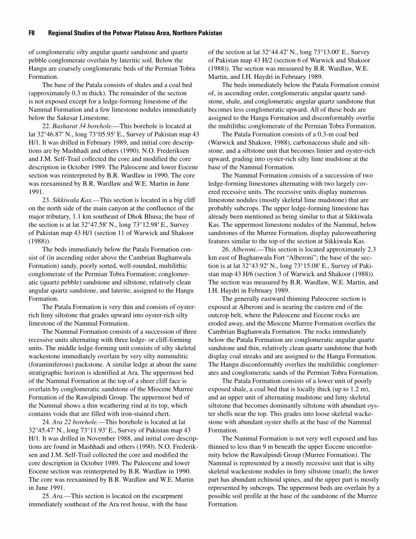
7. Nammal Dam.—This section was measured by B.R. Wardlaw, W.E. Martin, I.H. Haydri, J.M. Self-Trail, N.O. Frederiksen, and Tariq Masood in October 1989. The Lockhart Limestone was measured by J.R. SanFilipo in February 1990. Wardlaw and Martin revisited the section in June 1991. The section consists of a relatively well-exposed Patala Formation overlying a cliff-forming dip slope of Lockhart Limestone
and overlain by well-exposed Nammal Formation, and cliff-forming Sakesar Limestone. This section is the same as that measured by the Hydrocarbon Development Institute of Paki-stan (HDIP) and reported on by Köthe (1988) as the Nammal Gorge section and appears to be the same as that reported by Haque (1956; see discussion in “Stratigraphic Interpretation” section). The base of the Patala is located at lat 32°39.81′ N., long 71°48.05′ E., Survey of Pakistan map 38 P/14. The base of the Lockhart and the top beds of the Hangu measured by SanFilipo are in the gorge of the stream some 500 m northeast of the base of the Patala section.
The Lockhart Limestone measured by J.R. SanFilipo and collected for paleontology by E.M. Brouwers appears very similar to that described at Nammal Pass (compare sections 6 and 7, pl. F1). The Lockhart overlies a fossiliferous (mollusk-rich) sandstone at the top of the Hangu, just as it does at Nam-mal Pass.
The Patala Formation generally consists of dark-gray shales and glauconitic skeletal wackestones and packstones. The formation can be divided into three units: lower, middle, and upper. The lower unit is largely dark-gray shale that has common lime mudstone nodules in its lower half. The middle unit, forming a limestone ledge, consists of medium-bedded glauconitic, sandy skeletal wackestone at its base, becom-ing alternating wavy and nodular beds of glauconitic skeletal packstone at its top. The upper unit is dark-gray shales con-taining thin limy mudstones rich in planktic foraminifers and one bed of argillaceous lime mudstone. The unit is capped by a very limy sandstone.
The Nammal Formation is divided into two units: the lower marl facies and the upper limestone facies. These units are referred to as facies because they show a great deal of variation away from the Nammal Pass-Nammal Dam area. The lower marl facies is made up of very limy siltstone (marl), which forms swales broken by several limestone ledges of skeletal lime mudstone to wackestone. The base of the forma-tion is drawn at the sharp irregular contact between the top sandstone of the Patala and an overlying thin bed of fine skel-etal wackestone. Above the wackestone, only marls are found in the swales, and below the sandstone, only shales are found in the swales. It is unfortunate that the beds immediately over-lying this contact are covered, but there is a marked change in color of the soil (lighter), similar to that formed on the marl higher in the section. This change in color appears consistent for a great distance and is quite mappable from the Nammal Dam section to the Nammal Pass section. This formation contact is based on a mappable change in lithologies and not on proposed faunal zones.
The upper limestone facies of the Nammal forms a cliff of flat-bedded, silty to sandy, skeletal lime mudstone to wackestone. The facies is made up of less fossiliferous lime mudstone at its base and becomes more skeletal, thicker bed-ded, and wackestone dominated in its upper part.
A coarsely nodular-bedded Sakesar Limestone overlies in marked contrast to the relatively flat beds of the limestone facies of the Nammal Formation.
Stratigraphic Analysis of Paleocene and Lower Eocene Rocks F�
8. Kuraddi.—This section is located 0.5 kilometer (km) south of the village of Kuraddi, on the south limb of a tight anticline that is disrupted by two faults that repeat a minor amount of the section near the base. The base is at lat 32°31.67′ N., long 72°03.43′ E., Survey of Pakistan map 43 D/2 (section 31 of Warwick and Shakoor (1988)). The Lock-hart Limestone and the Patala and Nammal Formations were measured in February 1989 and the Hangu Formation was measured in October 1989, both instances by B.R. Wardlaw, W.E. Martin, and I.H. Haydri. The Patala was re-collected for paleontology by J.M. Self-Trail, N.O. Frederiksen, and Tariq Masood in October 1989. A poorly exposed carbonaceous shale overlying the Permian Amb Formation exposed in the core of the anticline was being mined in October 1989. This carbonaceous shale was not previously reported and appears to be Jurassic or Cretaceous (see Frederiksen and others, this volume, chap. D).
The sequence at Kuraddi is nearly completely exposed. A thin Lockhart Limestone overlies lateritic and bauxitic soils in the upper part of the Hangu Formation. The Lockhart is dupli-cated by faulting that exactly repeats the section bed for bed. The lower part of the sandstone unit within the Patala is also repeated; this observation is only demonstrable by mapping out all the unit contacts between several stream drainages.
The Hangu Formation consists largely of laterite and lateritic sandstones, and prominent bands of kaolinite occur in its upper part. The Lockhart Limestone consists of alternat-ing beds of sandy, limy, skeletal siltstone and medium-bedded sandy skeletal wackestone that is locally rich in bryozoans and contains common echinoid spines and a “Crepidula”-like gas-tropod. The Patala Formation consists of a basal unit of finely interbedded, laminated fine sandstone and shale (or mudstone) that is overlain by a cliff-forming burrowed sandstone. Most of the remainder of the formation consists of alternating limy skeletal siltstones and shales. The siltstones are locally rich in larger foraminifers. The siltstone-bearing interval occurs below and above a dark-gray shale that is slightly carbona-ceous.
The Nammal Formation shows a gradational contact with the underlying Patala Formation. This relation is typical in the Salt Range from this section eastward, where the contact is exposed. Skeletal siltstones at the top of the Patala grade into silty, skeletal limestones at the base of the Nammal. Com-monly, the same dominant fossils carry through the contact. In the case of the Kuraddi section, the fossils are larger foramini-fers and mollusks. The Nammal Formation consists of two cliff-forming skeletal wackestone to packstone units separated by a slightly recessive unit of silty, skeletal wackestone to lime mudstone. A recessive unit of Fasciolites marl makes up the top of the Nammal below the Sakesar Limestone.
9. Kathwai.—This section is located 2.3 km nearly due south of the village of Kathwai; the base is at lat 32°27.75′ N., long 72°11.42′ E., Survey of Pakistan map 43 D/3 (section 30 of Warwick and Shakoor (1988)). The section was measured by B.R. Wardlaw, W.E. Martin, and I.H. Haydri in February 1989.
The Lockhart Limestone is poorly exposed; only the upper limestone beds break through the soil-covered slope. Shale, sandstone, and thin lateritic soils of the Hangu Forma-tion overlying the Triassic Mianwali Formation are found scat-tered in small isolated outcrops below the Lockhart Limestone.
The Lockhart Limestone consists of alternating beds of limy siltstone (marl) and medium beds of silty packstone containing larger foraminifers. The Patala Formation is poorly exposed except for the sandstone in the lower part of the unit (this is the same sandstone unit identified as the “Dilliwala” sandstone complex of the Patala Formation by Warwick and Shakoor, this volume, chap. I). The contact between the Patala and Nammal is not exposed. The Nammal Formation consists of a lower covered recessive unit (marl(?)) that is inferred on the basis of regional relations. The exposed portion of the Nammal consists of a steep, cliff-forming, nodular skeletal wackestone overlain by a recessive unit of limy siltstone (marl) and skeletal wackestone to packstone, which is below a large cliff of the Sakesar Limestone.
10. Arara.—This section is located 3.2 km southeast of the village of Arara; the base is at lat 32°32.16′ N., long 72°23.54′ E., Survey of Pakistan map 43 D/6 (section 29 of Warwick and Shakoor (1988)). The section was measured by B.R. Wardlaw, W.E. Martin, and I.H. Haydri in February 1989 and was remeasured by Wardlaw, Martin, Haydri, and J.M. Self-Trail in October 1989.
The Arara section is generally poorly exposed through-out the area and is mostly covered with talus from cliffs of the Nammal Formation and Sakesar Limestone. Most of the sequence is exposed on a nose near the Rashid Tedi Mine. Here the Lockhart Limestone overlies a thick lateritic soil (4.6 m) that represents the entire Hangu Formation. The Hangu dis-conformably overlies the Permian Warchha Sandstone.
The Lockhart Limestone consists of a lower unit of medium- to thick-bedded, silty, skeletal packstone with com-mon echinoid spines and an upper unit of limy siltstone (marl), scattered limestone nodules, and common whole echinoid (sea biscuit) fossils preserved. The abundance of echinoid spines and of delicate whole fossils implies that these burrowing sedi-ment feeders are in place and may be greatly responsible for the burrowed nodular limestone so common in the Paleocene and Eocene units of the Salt Range.
The lower sandstone unit of the Patala Formation (“Dil-liwala” sandstone complex) directly overlies the Lockhart Limestone. The remainder of the Patala is generally not exposed, except for a portion in and around the small coal mines throughout the area.
The contact between the Nammal and Patala Formations is not exposed. The exposed portion of the Nammal consists of a lower cliff-forming unit and an upper recessive unit that forms a small ledge beneath the cliffs of the Sakesar Lime-stone.
11. PailKhushab Road.—This section is located 0.6 km north of a major switchback in the northern escarpment; the base of the Lockhart is at lat 32°35.83′ N., long 72°27.25′ E., Survey of Pakistan map 43 D/6 (section 28 of Warwick and
F� Regional Studies of the Potwar Plateau Area, Northern Pakistan
Shakoor (1988)). The section was measured by B.R. Wardlaw, W.E. Martin, and I.H. Haydri in February (Lockhart Lime-stone and the Patala and Nammal Formations) and October (Hangu Formation) 1989.
Most of the Lockhart Limestone and Nammal Formation is exposed as two very steep cliffs separated by a talus-covered slope representing the Patala and lower part of the Nammal Formation. The Lockhart Limestone overlies a thick cliff-forming sandstone at the top of the Hangu Formation.
The Hangu Formation consists of the aforementioned sandstone and an underlying lateritic sandstone and thick bauxite (3 m). The base of section is in a dense thicket, where the bauxite overlies Permian sandstone, probably of the Amb Formation.
The Lockhart Limestone consists of, in ascending order, a mudstone, a sequence of alternating cliff-forming nodular skeletal wackestone to packstone and slightly recessive silty nodular lime mudstone to packstone, followed at the top by thick-bedded (flat) skeletal packstone. Except for exposures in and about small coal mines, the Patala is covered by abundant coarse talus from the overlying steep cliffs of the Nammal Formation and Sakesar Limestone. The contact between the Nammal and Patala Formations is not exposed. The exposed Nammal consists of a steep cliff-forming lower unit of nodular skeletal packstone to wackestone and an upper unit that forms a steep slope of recessive limy, skeletal siltstone (marl) con-taining skeletal wackestone nodules. The Sakesar Limestone forms a sheer cliff above with a sharp contact with the upper unit of the Nammal.
12. Dhaman.—This section is located 0.6 km southwest of the village of Dhaman; its base is at lat 32°37.42′ N., long 72°29.25′ E., Survey of Pakistan map 43 D/6 (section 23 of Warwick and Shakoor (1988)). The section was measured by B.R. Wardlaw, W.E. Martin, and I.H. Haydri in February 1989.
The Lockhart Limestone overlies a thin lateritic soil and thick-bedded sandstone that make up the Hangu Forma-tion. The Hangu lies on the Permian Amb Formation. The Lockhart Limestone is not exposed at its base; the lowermost part is probably mudstone similar to section 11. The exposed Lockhart consists of limy mudstone (marl) containing muddy, skeletal wackestone nodules grading upward to limy siltstone (marl) containing skeletal wackestone nodules.
The base of the Patala Formation is not exposed but is probably shale similar to that exposed above the locally mined coal bed. The exposed part of the Patala consists of a thin coal bed (see Warwick and Shakoor, this volume, chap. I for thickness and description) and dark-gray shale overlain by limy, skeletal siltstone containing a few beds of silty, skeletal wackestone and a thin mudstone at the top.
The Nammal Formation is well exposed and consists of a basal recessive unit of skeletal wackestone and limy silt-stone (marl). This unit is overlain by a precarious cliff-form-ing sequence of sandy dolostone and thick-bedded nodular skeletal wackestone alternating with very nodular silty skeletal wackestone and limy siltstone (marl). The very nodular inter-vals form loose, rubbly, steep slopes between the cliffs of the
thick-bedded limestone. The contact with the overlying cliffs of the Sakesar Limestone is sharp and undulating.
13. Nila Wahan.—This section is located at the north point dividing major drainages to Nila Wahan Gorge, 2 km southeast of the village of Bhal; the base of the Lockhart is located at lat 32°38.67′ N., long 72°35.75′ E., Survey of Pakistan map 43 D/10 (section 20 of Warwick and Shakoor (1988)). B.R. Wardlaw, W.E. Martin, and I.H. Haydri mea-sured the Lockhart Limestone and the Patala and Nammal Formations in February 1989 and the Hangu Formation in October 1989. J.M. Self-Trail and N.O. Frederiksen sampled the section in October 1989.
The Hangu Formation disconformably overlies the Perm-ian Sardhai Formation and consists mostly of sandstone and scattered interbeds of shale, sandy siltstone, and laterite. The uppermost bed is micaceous sandstone.
The Lockhart Limestone consists of a lower recessive unit that grades from a limy mudstone containing skeletal lime mudstone, to wackestone nodules, to a limy siltstone contain-ing skeletal wackestone, to packstone nodules. Bryozoans are common in the upper part. A middle ledge-forming unit consists of nodular skeletal packstone to wackestone contain-ing common “Crepidula”-like gastropods and echinoid spines; larger foraminifers are abundant at the top. An upper recessive unit consists of sandy skeletal wackestone and limy siltstone that contains common oysters near the top. The uppermost unit consists of thick- to medium-bedded (flat) skeletal packstone to wackestone containing bryozoan and echinoid spine frag-ments. The uppermost unit is richly glauconitic.
The Patala Formation is poorly exposed, consisting of a lower unit of shale, a coal bed near the top, and an upper unit of skeletal, limy siltstone. The contact between the Patala and Nammal is not exposed, but beds representing the lowermost part of the Nammal are exposed and consist of skeletal wacke-stone and limy siltstone (marl). Most of the lower part of the formation is covered. The well-exposed part of the Nammal consists of alternating recessive and ledge-forming units that start in a recessive unit at the base and end in a recessive unit at its top. A thin, friable sandy dolostone occurs at the base of the second recessive unit. The contact with the cliffs of the overlying Sakesar Limestone is sharp.
14. Sohai River Gorge.—This section is located on a steep cliff on the east side of the gorge near the head of Sohai River (Sardahi) Gorge, 1.7 km southwest of the village of Khandoyah; the base of the section is at lat 32°43.92′ N., long 72°43.42′ E., Survey of Pakistan map 43 D/10 (base of section in carbonaceous shale of Hangu and nodular limestone of Lockhart is the same as section 19 of Warwick and Shakoor (1988) measured as Patala and Nammal in that paper). The section was measured by B.R. Wardlaw, W.E. Martin, and I.H. Haydri in February 1989.
The Lockhart Limestone overlies pisolitic laterite, car-bonaceous shales, a coal bed (0.3 m thick), and siltstones of the Hangu Formation just above the river. Beds of the Permian Sardhai Formation are exposed in the river.
Stratigraphic Analysis of Paleocene and Lower Eocene Rocks F7
The Lockhart Limestone consists of a lower unit of foraminifer-rich, skeletal wackestone to very limy skeletal mudstone, followed by a thin micaceous very fine sandstone to siltstone; a cliff-forming unit of slightly nodular sandy, muddy, foraminifer-rich, skeletal wackestone containing mudstone and shale partings; and an upper steep recessive unit of mostly very limy, foraminiferous mudstone, limestone nodules, and stringers of silty, foraminiferous wackestone. The upper unit grades into mudstones, siltstones, and shales that form the basal unit of the Patala Formation.
The Patala Formation is well exposed and consists of a lower unit that is mostly shale and two coal beds (0.1 and 0.2 m thick) that grade into a middle unit of mudstone. The upper part consists of a thin calcareous sandstone and a sandy, limy, abundantly foraminiferous siltstone that grades into sandy, limy siltstone containing common silty, foraminiferous wacke-stone nodules of the lower part of the Nammal Formation.
The Nammal Formation consists of a lower recessive unit described above, the upper part of which becomes covered by talus from the sheer cliff of the overlying unit of the Nammal. The base of the cliff is massive, containing undulating irregu-lar breaks. The lowermost part is lime mudstone that grades into skeletal wackestone that becomes more nodular (wavy bedded) but still massive. A massive sandy dolostone bed marks the center of the cliff and the end of our steady hand-holds and footholds. The remainder of the outcrop (cliff) could not be measured. Along a goat trail on the other side of the canyon, we estimated the remaining thicknesses and described the units. Two steep recessive units divided by a small cliff mark the upper part of the formation below the sheer cliff of the Sakesar.
15. Khairpur 9 borehole.—This borehole is located at lat 32°44.67′ N., long 72°47.00′ E., Survey of Pakistan map 43 D/14. It was drilled April–May 1987 (Alam and others, 1987), and initial core descriptions are by M. Anwar (written com-mun., 1989). N.O. Frederiksen and J.M. Self-Trail collected the core and modified the core description in October 1989. The Paleocene and lower Eocene section was reinterpreted by B.R. Wardlaw in 1990. The core was reexamined by B.R. Wardlaw and W.E. Martin in June 1991.
16. Khokhar Bala 10 borehole.—This borehole is located at lat 32°45.88′ N., long 72°48.83′ E., Survey of Pakistan map 43 D/13. It was drilled in June 1987 (Alam and others, 1987), and initial core descriptions are by M. Anwar and S.T.A. Mashhadi (written commun., 1989). N.O. Frederiksen and J.M. Self-Trail collected the core and modified the core description in October 1989. The Paleocene and lower Eocene section was reinterpreted by B.R. Wardlaw in 1990. The core was reexamined by B.R. Wardlaw and W.E. Martin in June 1991.
17. Dalwal 6 borehole.—This borehole is located at lat 32°43.33′ N., long 72°52.72′ E., Survey of Pakistan map 43 D/14. It was drilled in January 1987 (Alam and others, 1987), and initial core descriptions are by S.T.A. Mashhadi and M. Anwar (written commun., 1989). N.O. Frederiksen and J.M. Self-Trail collected the core and modified the core description
in October 1989. The Paleocene and lower Eocene section was reinterpreted by B.R. Wardlaw in 1990. The core was reexam-ined by B.R. Wardlaw and W.E. Martin in June 1991.
18. Chitti Dhan.—This section is located 4.3 km north-west of the village of Dandot on the south side of Gandhala Ravine; the base of the section is at lat 32°41.17′ N., long 72°55.83′ E., Survey of Pakistan map 43 D/14 (section D–1 of Hussain and Javed as reported by Warwick and Shakoor (1988)). The section was measured by B.R. Wardlaw, W.E. Martin, and I.H. Haydri in February 1989.
The Lockhart Limestone is absent at Chitti Dhan, but marine, fossiliferous sandy siltstone at the base of the Patala represents the lateral equivalent of the limestone. These silt-stones overlie variegated mudstones that are assigned to the Hangu Formation. The limestones of the Lockhart pinch out between the Sohai River Gorge and the Chitti Dhan section. The Hangu Formation unconformably overlies sandstones of the Permian Warchha Sandstone.
The lower part of the Patala Formation is partly exposed and consists of shales and a thin coal bed (0.2 m). The upper part of the formation is covered but interpreted to be alternat-ing fossiliferous siltstones and shales.
Most of the Nammal is exposed and consists of a thick recessive unit at the base, a middle ledge-forming unit that has a calcareous sandstone at its base, and a covered recessive unit, probably limy mudstone at the top. The upper recessive unit is covered by very coarse talus of the overlying Sakesar Limestone.
19. Dandot 14 borehole.—This borehole is located at lat 32°39.92′ N., long 72°56.12′ E., Survey of Pakistan map 43 D/14. It was drilled in February–March 1988, and initial core descriptions are by S.T.A. Mushhadi, M. Anwar, and H. Hussain (written commun., 1989). N.O. Frederiksen and J.M. Self-Trail collected the core and modified the core description in October 1989. The Paleocene and lower Eocene section was reinterpreted by B.R. Wardlaw in 1990. The core was reexam-ined by B.R. Wardlaw and W.E. Martin in June 1991.
20. Katas 3 borehole.—This borehole is located at lat 32°43.70′ N., long 72°58.23′ E., Survey of Pakistan map 43 D/14. It was drilled in March 1987 (Alam and others, 1987), and initial core descriptions are by T. Shakoor and S. Javed (written commun., 1989). N.O. Frederiksen and J.M. Self-Trail collected the core and modified the core description in October 1989. The Paleocene and lower Eocene section was reinterpreted by B.R. Wardlaw in 1990. The core was reexam-ined by B.R. Wardlaw and W.E. Martin in June 1991.
21. Basharat.—This section is located in hills north of the village of Basharat, 2 km to the north-northeast, with the base of section at lat 32°48.00′ N., long 73°06.00′ E., Survey of Pakistan map 43 H/1 (section 17 of Warwick and Shakoor (1988)). The section was measured by B.R. Wardlaw, W.E. Martin, and I.H. Haydri in February 1989.
The Basharat section represents a barely exposed thicket-covered slope. It does exhibit well the base of the Patala and the underlying unit. The beds immediately underlying the Patala are assigned to the Hangu Formation and consist
F� Regional Studies of the Potwar Plateau Area, Northern Pakistan
of conglomeratic silty angular quartz sandstone and quartz pebble conglomerate overlain by lateritic soil. Below the Hangu are coarsely conglomeratic beds of the Permian Tobra Formation.
The base of the Patala consists of shales and a coal bed (approximately 0.3 m thick). The remainder of the section is not exposed except for a ledge-forming limestone of the Nammal Formation and a few limestone nodules immediately below the Sakesar Limestone.
22. Basharat 34 borehole.—This borehole is located at lat 32°46.87′ N., long 73°05.95′ E., Survey of Pakistan map 43 H/1. It was drilled in February 1989, and initial core descrip-tions are by Mashhadi and others (1990). N.O. Frederiksen and J.M. Self-Trail collected the core and modified the core description in October 1989. The Paleocene and lower Eocene section was reinterpreted by B.R. Wardlaw in 1990. The core was reexamined by B.R. Wardlaw and W.E. Martin in June 1991.
23. Sikkiwala Kas.—This section is located in a big cliff on the north side of the main canyon at the confluence of the major tributary, 1.1 km southeast of Dhok Bhusa; the base of the section is at lat 32°47.58′ N., long 73°12.98′ E., Survey of Pakistan map 43 H/1 (section 11 of Warwick and Shakoor (1988)).
The beds immediately below the Patala Formation con-sist of (in ascending order above the Cambrian Baghanwala Formation) sandy, poorly sorted, well-rounded, multilithic conglomerate of the Permian Tobra Formation; conglomer-atic (quartz pebble) sandstone and siltstone, relatively clean angular quartz sandstone, and laterite, assigned to the Hangu Formation.
The Patala Formation is very thin and consists of oyster-rich limy siltstone that grades upward into oyster-rich silty limestone of the Nammal Formation.
The Nammal Formation consists of a succession of three recessive units alternating with three ledge- or cliff-forming units. The middle ledge-forming unit consists of silty skeletal wackestone immediately overlain by very silty nummulitic (foraminiferous) packstone. A similar ledge at about the same stratigraphic horizon is identified at Ara. The uppermost bed of the Nammal Formation at the top of a sheer cliff face is overlain by conglomeratic sandstone of the Miocene Murree Formation of the Rawalpindi Group. The uppermost bed of the Nammal shows a thin weathering rind at its top, which contains voids that are filled with iron-stained chert.
24. Ara 22 borehole.—This borehole is located at lat 32°45.47′ N., long 73°11.93′ E., Survey of Pakistan map 43 H/1. It was drilled in November 1988, and initial core descrip-tions are found in Mashhadi and others (1990). N.O. Frederik-sen and J.M. Self-Trail collected the core and modified the core description in October 1989. The Paleocene and lower Eocene section was reinterpreted by B.R. Wardlaw in 1990. The core was reexamined by B.R. Wardlaw and W.E. Martin in June 1991.
25. Ara.—This section is located on the escarpment immediately southeast of the Ara rest house, with the base
of the section at lat 32°44.42′ N., long 73°13.00′ E., Survey of Pakistan map 43 H/2 (section 6 of Warwick and Shakoor (1988)). The section was measured by B.R. Wardlaw, W.E. Martin, and I.H. Haydri in February 1989.
The beds immediately below the Patala Formation consist of, in ascending order, conglomeratic angular quartz sand-stone, shale, and conglomeratic angular quartz sandstone that becomes less conglomeratic upward. All of these beds are assigned to the Hangu Formation and disconformably overlie the multilithic conglomerate of the Permian Tobra Formation.
The Patala Formation consists of a 0.3-m coal bed (Warwick and Shakoor, 1988), carbonaceous shale and silt-stone, and a siltstone unit that becomes limier and oyster-rich upward, grading into oyster-rich silty lime mudstone at the base of the Nammal Formation.
The Nammal Formation consists of a succession of two ledge-forming limestones alternating with two largely cov-ered recessive units. The recessive units display numerous limestone nodules (mostly skeletal lime mudstone) that are probably subcrops. The upper ledge-forming limestone has already been mentioned as being similar to that at Sikkiwala Kas. The uppermost limestone nodules of the Nammal, below sandstones of the Murree Formation, display paleoweathering features similar to the top of the section at Sikkiwala Kas.
26. Alberoni.—This section is located approximately 2.3 km east of Baghanwala Fort “Alberoni”; the base of the sec-tion is at lat 32°43.92′ N., long 73°15.08′ E., Survey of Paki-stan map 43 H/6 (section 3 of Warwick and Shakoor (1988)). The section was measured by B.R. Wardlaw, W.E. Martin, and I.H. Haydri in February 1989.
The generally eastward thinning Paleocene section is exposed at Alberoni and is nearing the eastern end of the outcrop belt, where the Paleocene and Eocene rocks are eroded away, and the Miocene Murree Formation overlies the Cambrian Baghanwala Formation. The rocks immediately below the Patala Formation are conglomeratic angular quartz sandstone and thin, relatively clean quartz sandstone that both display coal streaks and are assigned to the Hangu Formation. The Hangu disconformably overlies the multilithic conglomer-ates and conglomeratic sands of the Permian Tobra Formation.
The Patala Formation consists of a lower unit of poorly exposed shale, a coal bed that is locally thick (up to 1.2 m), and an upper unit of alternating mudstone and limy skeletal siltstone that becomes dominantly siltstone with abundant oys-ter shells near the top. This grades into loose skeletal wacke-stone with abundant oyster shells at the base of the Nammal Formation.
The Nammal Formation is not very well exposed and has thinned to less than 9 m beneath the upper Eocene unconfor-mity below the Rawalpindi Group (Murree Formation). The Nammal is represented by a mostly recessive unit that is silty skeletal wackestone nodules in limy siltstone (marl); the lower part has abundant echinoid spines, and the upper part is mostly represented by subcrops. The uppermost beds are overlain by a possible soil profile at the base of the sandstone of the Murree Formation.
Stratigraphic Analysis of Paleocene and Lower Eocene Rocks F�
Paleontologic ControlPaleontologic control for the upper Paleocene to lower
Eocene units is sparse. Many of the units are marginal-marine to shallow-marine deposits but lack abundant planktic forms that would be age diagnostic. Pollen and spores are com-monly abundant in carbonaceous shales, but these lithologies are not common in the section. The remainder (most) of the section appears to be well oxidized, and oxidation has elimi-nated pollen and spores from the rocks, especially in surface sections. The common diagenetic overprint appears to have recrystallized or removed many planktic forms. Ostracodes appear to be common to most sections, but these abundant faunas have not been adequately studied. Nevertheless, enough fossil control exists for a preliminary model. Of importance are the paleontologic studies of this volume (chapters B, C, D, and E) that establish the ages of a regional reference section at Nammal Dam. These studies basically corroborate earlier studies of Köthe (1988). The foraminifer study of Afzal and Daniels (1991) is also important in that it shows a nearly continuous succession of planktic foraminifers for the latest Paleocene and early Eocene at Khairabad in the northern Salt Range. The flora reported by Edwards (this volume, chap. C) from the Basharat core that yielded an early Eocene age for the Nammal Formation (early NP 10?) and the disparate ages indicated by floras from a section near Ara reported by Köthe (1988) are very important. Köthe’s (1988) material is not well constrained stratigraphically in her presentation. The difficulty of identifying the Patala Formation and differentiating it from the Hangu Formation in the eastern Salt Range is a problem that probably was not addressed for her study. Regardless, the dinoflagellate floras reported from the Patala by Köthe (1988) that indicate probable NP 8 and NP 10 ages indicate a signifi-cant hiatus in the unit she identifies as Patala.
In the course of fieldwork, we noticed that the first abundant occurrence of the larger foraminifer Fasciolites globosa appeared to be a useful marker for comparing sec-tions. There is no particular reason that the abundant first occurrence of this foraminifer should be a time marker, but we continue to utilize it as a “datum” for interpreting our sections throughout the Salt Range. The paleontologic data from the studies in this volume and from previous work on the various units of the Salt Range are summa-rized in figure F2. The ages of units from our Nammal Pass and Nammal Dam sections are reviewed in more detail in the “Stratigraphic Interpretation” section below.
LithofaciesEleven general lithofacies are recognized for this study
(figs. F3 and F4).Facies 1.—Oxysol, sand, and mud of the Hangu Forma-
tion consist of laterites, lateritic soils, and bauxites interbedded with a variety of generally dirty sands, commonly with clay
and coal streaks, and muds, micaceous in places. Coal beds in the sections studied are common to those that are “basinal,” occurring within the depositional trough (Warwick and Ward-law, 1992) rather than along its margin and are associated with oxysols or muds. Coal beds are common within the Hangu on the Kohat Plateau and are associated with sands (Khan, 1992).
Facies 2.—Shoreface sand of the Hangu Formation is silty to clean, bioturbated, generally medium sand contain-ing scattered to common mollusks and calcareous cement, generally occurring in the upper part of the Hangu in “basinal” settings (fig. F3).
Facies 3.—Skeletal lime sand of the Lockhart, Margala Hill, and Sakesar Limestones is skeletal wackestone to pack-stone, generally containing larger foraminifers; in addition, dasyclad and red algae, bryozoans, mollusks, and other fora-minifers are common accessories. Lime mudstone is rare, and the beds are typically wavy to nodular.
Facies 4.—Foraminiferous lime mud of the Lockhart Limestone is skeletal lime mudstone to wackestone, contain-ing common planktic foraminifers in the foraminifer constitu-ents and is “basinal” in distribution (Warwick and Wardlaw, 1992).
Facies 5.—Sand of the Patala Formation is medium- to fine-grained, bioturbated, well-sorted, subrounded quartz, con-taining silica cement. It has a limited distribution, generally marking the western limit of coal-bearing Patala Formation and represents barrier sands (Warwick and Shakoor, 1988, and this volume, chap. I, and sections 8–10 in fig. F4).
Facies 6.—Mud and shale of the Patala Formation represent a variety of generally fine-grained clastic sediments that are rooted, carbonaceous, coal-bearing, fossiliferous, marginal-marine swamp deposits (Frederiksen and others, this volume, chap. D). Warwick and Shakoor (this volume, chap. I) report local sandstone lenses within this facies that either were not observed or were assigned to the Hangu in this report.
Facies 7.—Skeletal silt of the Patala Formation is fora-minifer- and mollusk-bearing skeletal limy siltstone, to silty lime mudstone, to packstone, commonly distributed in the upper part of the Patala Formation in the Salt Range (fig. F4). Sparsely skeletal sand, mud, and shale are rare constituents.
Facies 8.—Marine shale and marl of the Patala Formation are finely skeletal, dark-gray to olive-drab shale, marly shale, and marl containing common planktic foraminifers. Fine sand is common locally as sandstone or as a common constituent in shale and marl.
Facies 9.—Marl and nodular limestone of the Nammal Formation and Margala Hill Limestone are interbedded with marl and nodular skeletal lime mudstone to packstone. The marl commonly contains limestone nodules.
Facies 10.—Flat-bedded limestone of the Nammal For-mation is skeletal lime mudstone, cherty in places, containing common planktic foraminifers. It is equivalent to the forami-niferous lime mud facies of the Lockhart Limestone but differs in that it is flat bedded compared with the typically wavy- to nodular-bedded Lockhart. It also represents a “basinal” facies like its equivalent in the Lockhart.
F10 Regional Studies of the Potwar Plateau Area, Northern Pakistan
NPZONE Khairabad Nammal Khairpur Dandot Choa Basharat Ara
NP 14
SAKESAR LIMESTONE
low
er
Eo
cene NP 13
NP 12 NAMMAL FORMATION
NP 11
NAMMALPATALA FORMA
FORMATION
NP 10TION
PATALA
uppe
r Pal
eoce
ne
NP 9 FORMATION
NP 8LOCKHART LIMESTONE
NP 7
NP 6 HANGU FORMATION
EPOC
H SECTION OR BOREHOLE
Figure F2. General age (shown as nannofossil zones) of units in the Salt Range from sections using faunas or floras as controls, from Khairabad to Ara. Nannofossil zones based on data from Köthe (1988) and Edwards (this volume, chap. C); sections from Köthe with additional data on the Nammal section and the Khairpur and Basharat boreholes from Edwards. Stripes indicate hiatus.
Facies 11.—The red beds of the “red” Patala facies are red siltstone and mudstone containing sandy conglomeratic beds and conglomerate of chert and limestone pebbles and abraded larger foraminifers. This facies has a limited distribu-tion, found only at the Cherat section of this study. Warwick and Wardlaw (1992) reported this facies elsewhere (Kohat Pass) and discussed its significance in some detail.
Stratigraphic Interpretation
The Murree Hills and Kala Chitta Range sections (sec-tions 1 and 2) are similar to those of the Salt Range (sections 6–26) (pl. F1). The Hangu Formation is missing at the base of sections 1 and 2; the Nammal Formation and Sakesar Limestone are not recognized as separable map units and are thus included in the equivalent Margala Hill Limestone. The Murree Hills section is highly folded. In the Kala Chitta Range section, the Margala Hill Limestone is overlain by the Bhadrar beds of Jurgan and Abbas (1991). These beds have been previ-
ously mapped as part of the Chorgali Formation (see Qureshi, 1992) and have also been reported overlying the Sakesar Limestone in the Salt Range. Jurgan and Abbas (1991) right-fully pointed out that these nodular limestones are indeed the same unit in both the Kala Chitta Range and Salt Range but are not the Chorgali Formation, which is a dolostone and shale unit representing deposition in a restricted environment in its type area. Therefore, Jurgan and Abbas (1991) referred to the unit as the Bhadrar beds, which they included as the top unit of the Sakesar Limestone.
The Cherat Range section (fig. F3, section 4) has the Hangu Formation and Lockhart Limestone at its base but dif-fers from other sections by its somewhat enigmatic red beds overlying the Lockhart. The red beds, described as facies 11, have reworked, abraded, larger foraminifers in conglomer-atic beds. No other fossils are apparent. Meissner and others (1974), in a section nearby at Dag, assigned the red beds to the Mami Khel Clay (=Kuldana Formation) because they are over-lain by the Kohat Formation. Similarly, Ahmad Hussain, Said Rahim, Tariq Shakoor, and Abdul Latif (GSP, written com-mun., 1990) assigned this unit to the Patala Formation because
Stratigraphic Analysis of Paleocene and Lower Eocene Rocks F11
Figure F�. Fence diagram of sections displaying general stratigraphy in the area adjacent to the Potwar Plateau and showing lithofacies present in each unit. Heights are given in feet and meters above the base of the Tertiary section. The inset map shows the location of sections: 1, Murree Hills; 2, Kala Chitta Range; 4, Cherat Range; 5, Lumshiwal Nala (Makarwal); 6, 7, Nammal Pass and Nammal Dam.
200
400
600
800
0
100
200
6,75421
PATALA FORMATION
PATALA
FORMATION
MARGALA HILL
LIM
ESTONE
"BHA
DRAR
BED
S"
FACIES 8
FACIES
11
FACI
ES 3
FACIES 10
FACIES 2
FACIES 9
FACIES 8
FACIES 3FACIES 4
"RED"
PATA
LA
INTERBEDDEDFACIES
3&9
50 KM
30 MI
FACIES 3
FACIES 1
METERS FEET
NAMMALFORMATION
LOCKHARTLIMESTONE
HANGUFORMATION
SAKESAR LIMESTONE
Sal t Range
Kohat
Jhelum
Soan River
Indu
sRi
ver
Rive
rJh
elum
River
Jhelum
Kurram
River
Bannu
Hangu
MakarwalKheji
Attock City
Rawalpindi
Islamabad
Peshawar
32°
33°
34°71° 72° 73°
0
0
10
10
20
20
30 MILES
30 40 KILOMETERS
P o t w a rP l a t e a u
Surg
har
Range
1
2
4
56 7
F12 Regional Studies of the Potwar Plateau Area, Northern Pakistan
it overlies the Lockhart Limestone. The Kuldana Formation generally overlies the Bhadrar beds in the Kala Chitta Range and the upper part of the Panoba Shale or Shekhan Limestone in the Kohat area (see Warwick and Wardlaw, 1992), not the Lockhart Limestone. The Patala Formation does not consist of red beds. We, therefore, refer to these beds as the “red” Patala facies (following Warwick and Wardlaw, 1992) and suggest that they probably represent a new unit that is neither Patala nor Kuldana.
The Hangu Formation is coal bearing at the Cherat Range, Makarwal, Nammal, and Sohai River Gorge sections (sections 4, 5, 6, 7, and 14). In the Cherat Range, it is made up largely of mudstone and a few thick laterites near its base. The unit is dominated by sandstone at both Makarwal and Nam-mal, and several thin lateritic soils occur at the Nammal sec-tions. The formation at all three of the above localities grades into a marine facies in the upper part, generally represented by shoreface sands and abundant mollusks. This shoreface facies is thickest at Makarwal (fig. F3, section 5, facies 2). The
Hangu coal bed at Sohai River Gorge overlies a laterite and underlies shales and siltstones that are micaceous in places. This coal is slightly enigmatic; the other Hangu coals appear to reflect deposition in a topographic trough at initial Paleo-cene transgressions (they are all centered in the depositional trough of Warwick and Wardlaw, 1992). The coal bed of the Sohai River Gorge perhaps also reflects a topographic low at the time of initial transgression.
The Patala Formation is dominated by marine siltstones and shales throughout the area represented by the sections of figure F3 and does not contain coal.
Some differences exist concerning the thickness and qual-ity of exposure of the section in the gorge at Nammal Dam (Gibson, this volume, chap. E). We have examined the entire area and find the best exposure to be at the location where we measured the section. The area Gibson (this volume, chap. E) alludes to as a better section has Lockhart slumped over the entire lower part of the Patala and no exposure of that part of the section. The remainder is a little less exposed than the
Figure F�. Fence diagram of sections in the Salt Range showing relation of facies to datum of Fasciolites acme zone. The inset map shows the locations of sections: 6, Nammal Pass; 7, Nammal Dam; 8, Kuraddi; 9, Kathwai; 10, Arara; 11, Pail-Khushab Road; 12, Dhaman; 13, Nila Wahan; 14, Sohai River Gorge; 15, Khairpur
9 borehole; 16, Khokhar Bala 10 borehole; 17, Dalwal 6 borehole; 18, Chitti Dhan; 19, Dandot 14 borehole; 20, Katas 3 borehole; 21, Basharat; 22, Basharat 34 borehole; 23, Sikkiwala Kas; 24, Ara 22 borehole; 25, Ara; 26, Alberoni. The location of the Salt Range is shown in the inset map of figure F3.
Stratigraphic Analysis of Paleocene and Lower Eocene Rocks F1�
section we measured. We also conclude that our section is the same as that measured by Haque (1956) and by HDIP and reported on by Köthe (1988) and Jurgan and others (1988). First, the HDIP section is painted along the same traverse as ours and, as pictured in internal reports, is the same as ours. Unfortunately, only the upper part of the section is reported on by Jurgan and others (1988, see fig. F5). The entire section sampled for Köthe’s (1988) report has not yet been illustrated. Second, Haque’s (1956) section shows all the subtle units of ours (fig. F5), and so we feel they are from the same place. Haque (1956) exaggerated the thickness by not correcting adequately for the dip. Calculating the map distance and dip shown by Haque (1956) for the sections (Gibson’s traverse or ours) clearly demonstrates that Haque’s columnar section is at least 500 ft (152 m) too thick for the rocks as mapped. In addition, we feel that Haque’s (1956) illustration of complete exposure is more a matter of artistic license (or drafting style) than substantive reality.
Haque (1956) reported Morozovella velascoensis and associated foraminifers from the Nammal Formation, though his illustrated forms are all from the Patala Formation. This planktic foraminifer and associated fauna are diagnostic of the latest foraminifer zone of the late Paleocene. Gibson (this volume, chap. E) documents the last occurrence in his mate-rial within the Patala Formation. A sample that is equivalent to Haque’s highest occurrence (sample NP2–4) was barren of planktic foraminifers and contained a fair but poorly preserved nannofossil flora (Bybell and Self-Trail, this volume, chap. B), and a few dinoflagellate cysts that indicated an early Eocene age (Edwards, this volume, chap. C).
In an effort to resolve the potential conflict in age inter-pretations, B.R. Wardlaw and W.E. Martin resampled the inter-val in question (samples NP4–1 and NP4–2; see this volume, chap. B). Sample NP4–1 yielded abundant nannofossils and indicates an Eocene age (NP 11, chap. B). Similarly, Köthe (1988) reported an early Eocene age (NP 11) on the basis of nannofossils and dinoflagellates for the lower part of the Nammal Formation from the HDIP section at Nammal Gorge. Therefore, because recovery of foraminifers from this interval could not be duplicated and the interval clearly yields Eocene floras, we have to discount the reported but unsubstantiated occurrence of foraminifers diagnostic of the late Paleocene from this lowest part of the Nammal Formation reported by Haque (1956) in an exaggerated section and championed by Gibson (this volume, chap. E).
Compilation of the age data available for the Nammal section (this volume, chaps. B–E and Köthe (1988)) is shown in figure F6. Also shown is the agreement of the section at Makarwal with that composited for the Nammal area (Hangu Formation and Lockhart Limestone from the Nammal Pass section, Patala and Nammal Formations from the Nammal Dam section). Clearly, the upper part of the Patala Forma-tion can be seen as a lateral equivalent of the marl facies of the Nammal Formation, probably representing a more off-shore facies. This relation resolves the problem (Bybell and Self-Trail, this volume, chap. B) with the Eocene ages for the
Patala reported by Köthe (1988) in the Kohat Plateau. In a transitional section from Nammal to Makarwal in the northern Salt Range identified as Khairabad-east, Afzal and Daniels (1991) reported a nearly continuous planktic foraminifer succession (converted to nannofossil zone equivalents for comparison) from NP 9 in the uppermost part of the Lockhart Limestone (transitional to Patala), NP 9–NP 12 for the Patala Formation, and NP 12–NP 14 for the Nammal Formation. More important, the Morozovella subbotinae subbotinae/Morozovella velascoensis acuta Zone is restricted to samples from the lower 30 ft (9 m) of the Patala Formation and the upper 5 ft (1.5 m) of the Lockhart Limestone. These data sug-gest that the apparent hiatus at the unconformity dividing the Patala and Nammal Formations at Nammal is not present in more offshore, basinal sections.
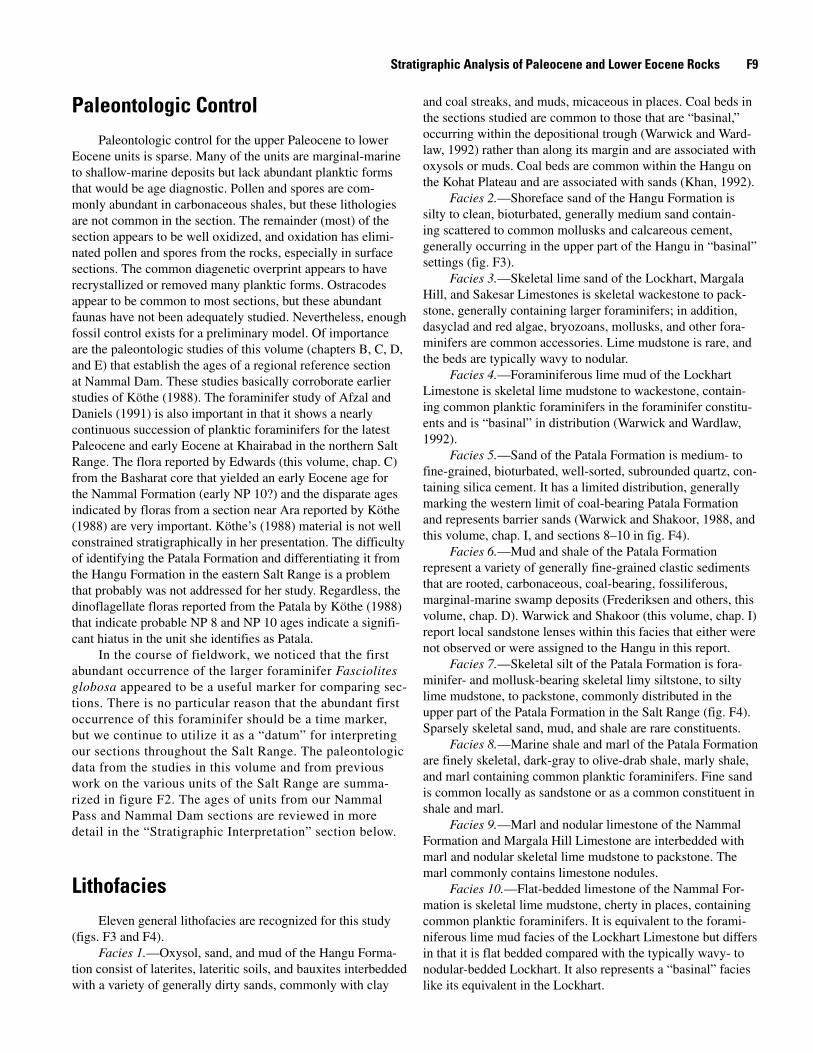
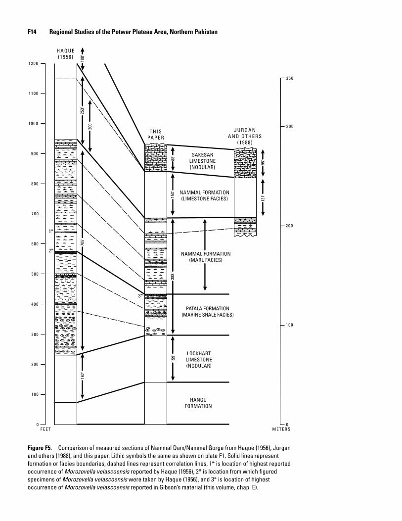
Sequence StratigraphyThe deposition of Paleocene and lower Eocene rocks of
the area within and adjacent to the Potwar Plateau was in three transgressive-regressive (T–R) packages, or sequences, on the shelf (fig. F7) that merge into one major T–R package in the depositional trough or “basin” (fig. F7). The dividing sequence boundaries (unconformities) disappear in “basinal” settings westward in the middle of the depositional trough (fig. F1). The major T–R package in the basin corresponds to deposi-tion from NP 6 to NP 13 probably at a time between the major drops in sea level in late NP 5 and NP 13 (see fig. F8). Brief periods of nondeposition may reflect intervening lowstands, but that is uncertain from the data available. The three T–R packages represented on the shelf of the Pakistan-India plate do not correspond as well to the eustatic changes in sea level, suggesting that tectonic and climatic factors were important to their deposition.
The first T–R package consists of the Hangu Formation, Lockhart Limestone, and lower part of the Patala Formation. Where the Hangu was deposited on a shelf, it is represented by facies 1 (oxysol, sand, and mud) and rare coal beds. Where it was deposited in the trough, the Hangu is coal bearing and has a marine shoreface sand, which suggests that the depositional trough was marginally marine and was dominated by sands, oxysols, and swamps in a probable tropical setting. This initial transgressive deposition of marginal-marine environments in the “basin” and more terrestrial environments on the shelf was then overlain by the carbonates of the Lockhart Lime-stone. The Lockhart Limestone contains foraminiferous muds where it was deposited in the trough and foraminiferous sands where it was deposited on the shelf from start to end, imply-ing relatively rapid transgression over an inherited topography that differentiated the facies distribution. Maximum transgres-sion is represented by the onlap of marine shales of the Patala Formation onto the shelf (NP 9, late Paleocene). On the shelf, the Patala Formation is coal-bearing mud and shale and a bar-rier sand. Warwick and Shakoor (this volume, chap. I) detail
F1� Regional Studies of the Potwar Plateau Area, Northern Pakistan
J U R G A NA N D O T H E R S
( 1 9 8 8 )
T H I SPA P E R
H A Q U E( 1 9 5 6 )
M E T E R SF E E T0
1 0 0
2 0 0
3 0 0
4 0 0
5 0 0
6 0 0
7 0 0
8 0 0
9 0 0
1 0 0 0
1 1 0 0
1 2 0 0
3 5 0
3 0 0
2 0 0
1 0 0
0
HANGUFORMATION
LOCKHARTLIMESTONE(NODULAR)
PATALA FORMATION(MARINE SHALE FACIES)
NAMMAL FORMATION(MARL FACIES)
NAMMAL FORMATION(LIMESTONE FACIES)
SAKESARLIMESTONE(NODULAR)
188'
200'
253'
705'
167'
159'
388'
153'
88'
95'
131'
1*
2*
3*
Figure F�. Comparison of measured sections of Nammal Dam/Nammal Gorge from Haque (1956), Jurgan and others (1988), and this paper. Lithic symbols the same as shown on plate F1. Solid lines represent formation or facies boundaries; dashed lines represent correlation lines, 1* is location of highest reported occurrence of Morozovella velascoensis reported by Haque (1956), 2* is location from which figured specimens of Morozovella velascoensis were taken by Haque (1956), and 3* is location of highest occurrence of Morozovella velascoensis reported in Gibson’s material (this volume, chap. E).
Stratigraphic Analysis of Paleocene and Lower Eocene Rocks F1�
800
200
600
400
100
200
00
FEET METERS
HANGUFORMATION
LOCKHARTLIMESTONE
PATALA FORMATION
NAMMAL FORMATION(MARL FACIES)
NAMMAL FORMATION(LIMESTONE FACIES)
SAKESAR LIMESTONENAMMALMAKARWAL
NP 13
NP 12
NP 11
NP 9
NP 8
NP 6–NP 8
PALE
OCE
NE
EOCE
NE
Figure F�. Comparison of formations and lithologies of sections and inferred age (in nannofossil zones) at Makarwal and Nammal Dam, showing facies relation of Patala and Nammal Formations. Solid lines represent formation or facies boundaries; dashed lines represent correlation lines. Lithic symbols are the same as those shown on plate F1. Nannofossil zones are based on data from Köthe (1988) and chapters B–E of this volume.
F1� Regional Studies of the Potwar Plateau Area, Northern Pakistan
HIATUS
HIATUS
HIATUS
HIATUS
Sandstone Marl
Coal Mudstone
Limestone Nodular limestone
Marine shale Marine siltstone
SAKESARLIMESTONE
PATALA NAMMAL
FORMATION FORMATION
LOCKHART
LIMESTONE
HANGU
TION
FORMA
NAMMAL FORMATION
NAMMAL? FORMATION
PATALA? FORMATION
PATALA FORMATION
R3
T 3
R 2
R 1 T 2
T 1
BASIN SHELF
Figure F7. Model of Paleocene and lower Eocene depositional packages within and near the Potwar Plateau. T, transgression; R, regression.
RANGE IN AGE FOR DEPOSITIONNP ZONE EPOCH SEA LEVEL ON THE SHELF
FALLING
NAMMAL FORMATION
NAMMAL FORMATION ? EOCE
NE
PATALA FORMATION
LOCKHART LIMESTONE
HANGU FORMATION
PALE
OCEN
E
RISING
PATALA FORMATION ?
14
13
12
11
10
9
876
5
4
Figure F�. Eustatic sea-level changes (from Haq and others, 1987) compared with probable range in age of deposition of Paleocene and Eocene units on the shelf and nannofossil zones. Nannofossil zones based on data from Köthe (1988) and Edwards (this volume, chap. C).
Stratigraphic Analysis of Paleocene and Lower Eocene Rocks F17
the distribution of these units and the coal beds. The coal beds resulted from marginal-marine (brackish) swamps (see Frederiksen and others, this volume, chap. D) shoreward of the barrier sands in large back bays that occupied the shelf. The coal beds are in close association with kaolinite and illite clays (Whitney and others, 1990) and suggest deposition in a sub-tropical setting. Having carbon tied up in coal and carbonates in close proximity strongly suggests seasonality. The back-bay and barrier environments prograded out over marine units in the regressive phase at the end of this package. A significant unconformity cuts through the Patala on the shelf.
The diachroneity of the transgressive units of T–R pack-ages 1 and 3 suggests transgression from a general west to east or northwest to southeast direction (fig. F7). However, the diachroneity of the transgressive unit of T–R package 2 is very different (figs. F2 and F7), suggesting transgression from the northeast. The time of transgression of T–R package 2 appears to be earliest Eocene (NP 10). Warwick and Wardlaw (1992) postulated northern closure of the depositional trough in the late Paleocene, and deposition of T–R package 2 could be related to this closure and cutoff of access from the trough and onlap from the north-northeast from the “Tethyan” sea.
T–R package 2 consists of the upper part of the Patala Formation (facies 7, skeletal silt) and lower part of the Nam-mal Formation (part of facies 9, marl) and was deposited only on the shelf. Deposition was in a very shallow marine environ-ment, and oysters are common to both the Patala and Nammal in this package. Packstones containing larger foraminifers to grainstones replete with nummulitid foraminifers are not uncommon in the Nammal Formation, perhaps supporting the “Tethyan” influence of the T–R package. Warwick and Sha-koor (this volume, chap. I) identify a unit, the Sidhandi shale bed within the Nammal Formation in the eastern Salt Range. This unit was not exposed in any of our surface sections. It may be represented in the boreholes. Warwick and Shakoor (chap. I) observed it in small mines of the aluminum-rich clays (kaolinite) of the unit. It is possible that this unit represents a soil profile at the top of T–R package 2. The Sidhandi shale bed may be equivalent to the sandy dolostone or calcareous sand (Wardlaw and others, 1990) found in the sections at Sohai River Gorge, Nila Wahan, and Dhaman (pl. F1) in the central Salt Range. The sand and sandy dolostone are part of a weathering profile. The timing of this T–R package seems to coincide with the eustatic sea-level rise in the early Eocene (NP 10, fig. F8). Closure of the northern end of the trough and cutoff of influence of the trough on the deposition of this pack-age may represent a short interval where the eustatic signal was the major driving force in deposition.
T–R package 3 consists of the Nammal Formation and Sakesar Limestone on the shelf. The T–R package appears to represent a return of influence from the trough and trans-gression from the west or northwest and a masked eustatic influence or signal. Maximum transgression is represented by the onlap of lime mudstones of the Nammal Formation (NP 13(?)). Regression is represented by the same facies (lime mudstone) prograding out into the trough (at Makarwal),
followed by Sakesar Limestone deposition. Deposition was generally shallow marine except for the lime mudstone con-taining common planktic foraminifers that suggests offshore deposition. The lack of coals or carbonaceous shale in T–R packages 2 and 3 suggests the combined influence of a more marine setting (lacking swamps) and further migration of the Pakistan-India plate into more northern latitudes less condu-cive to swamp (and coal) formation.
Conclusions
Paleocene and lower Eocene sediments found in and adjacent to the Potwar Plateau represent deposition in a “basinal” setting within the center of a trough developed between the Afghanistan and Pakistan-India plates and in a “shelfal” setting along the margin of the Pakistan-India plate. Shelf deposition is represented by three transgressive-regres-sive packages: the first in the upper Paleocene (NP 6–NP 9), the second in the lowest Eocene (NP 10–NP 11), and the third in the lower Eocene (NP 11–NP 14).
Coal within the Salt Range is present in the Hangu For-mation, where it is intimately related with oxysols and shore-face deposits. Coal is common in the regressive sedimentation of the Patala Formation, representing swamp and pervasive back-bay deposition. Outside the Salt Range, coal deposition appears limited to the lower part of the initial transgressive package of the Hangu Formation in marginal-marine environ-ments. The coals of the Hangu are intimately related with oxysols and are of a generally better quality than those of the Patala, probably resulting from deposition in tropical, ever-wet conditions. The coals of the Patala are intimately related with marine sediments or poorly developed soils commonly containing various clay mineralogies (kaolinite and illite) and probably resulting from deposition in seasonal, subtropical conditions. This change in quality of the coals and deposi-tional setting appears to be related to the movement of the Pakistan-India plate north through climatic zones.
References Cited
Afzal, Jamil, and Daniels, C.H.v., 1991, Foraminiferal bio-stratigraphy and paleoenvironment interpretation of the Paleocene to Eocene Patala and Nammal Formation from Khairabad-East, western Salt Range, Pakistan: Pakistan Journal of Hydrocarbon Research, v. 3, p. 61–79.
Alam, G.S., Bhatti, N.A., Mashhadi, S.T.A., Shakoor, Tariq, Javed, Shahid, and Anwar, Muhammad, 1987, Coal deposits of Dalwal Plateau, District Chakwal, eastern Salt Range, Punjab, Pakistan: Geological Survey of Pakistan Informa-tion Release 325, 33 p.
F1� Regional Studies of the Potwar Plateau Area, Northern Pakistan
Danilchik, Walter, and Shah, S.M.I., 1987, Stratigraphy and coal resources of the Makarwal area, Trans-Indus Moun-tains, Mianwali District, Pakistan: U.S. Geological Survey Professional Paper 1341, 38 p., 4 pls. in pocket.
Haq, B.U., Hardenbol, Jan, and Vail, P.R., 1987, Chronology of fluctuating sea levels since the Triassic: Science, v. 235, p. 1156–1167.
Haque, A.F.M.M., 1956, The Foraminifera of the Ranikot and the Laki of Nammal Gorge, Salt Range: Geological Survey of Pakistan Memoirs, v. 1, 293 p.
Jurgan, H., and Abbas, G., 1991, On the Chorgali Forma-tion at the type locality: Pakistan Journal of Hydrocarbon Research, v. 3, p. 35–45.
Jurgan, H., Abbas, G., and Mujtaba, M., 1988, Depositional environments and porosity development in lower Eocene limestone formation of the Surghar Range, Salt Range, and Potwar basin, Pakistan: Hannover, Germany, Technical Cooperation Report, Project 83.2068.1, 80 p.
Khan, Asif, 1992, Hangu coal drilling project [abs.]: Islam-abad, Pakistan, First South Asia Geological Congress, Abstracts, p. 61.
Köthe, Angelika, 1988, Biostratigraphy of the Surghar Range, Salt Range, Sulaiman Range, and the Kohat area, Paki-stan, according to Jurassic through Paleogene calcareous nannofossils and Paleogene dinoflagellates: Geologisches Jahrbuch, pt. B, v. 71, p. 3–87.
Mashhadi, S.T.A., Javed, S., Anwar, M., Hussain, H., and Alam, G.S., 1990, Coal deposits of Ara-Basharat Plateau, District Chakwal, eastern Salt Range, Punjab, Pakistan: Geological Survey of Pakistan Information Release 456, 32 p.
Meissner, C.R., Master, J.M., Rashid, M.A., and Hussain, Muzaffar, 1974, Stratigraphy of the Kohat quadrangle, Paki-stan: U.S. Geological Survey Professional Paper 716–D, 30 p.
Qureshi, K.A., 1992, Stratigraphic and structural evolution of Kala-Chitta Range, Punjab [abs.]: Islamabad, Pakistan, First South Asia Geological Congress, Abstracts, p. 61.
Scotese, C.R., Gahagan, L.M., and Larson, R.L., 1988, Plate tectonic reconstructions of the Cretaceous and Cenozoic ocean basins: Tectonophysics, v. 155, p. 27–48.
Shah, S.M.I., 1977, Stratigraphy of Pakistan: Geological Sur-vey of Pakistan Memoirs, v. 12, 138 p.
Wardlaw, B.R., Martin, W.E., and Haydri, I.H., 1990, Prelimi-nary lithofacies analysis of the Lockhart, Patala, and Nammal Formations (Paleocene–Eocene) of the Salt Range: Geologi-cal Survey of Pakistan Project Report (IR) PK–90, 40 p.
Warwick, P.D., and Shakoor, Tariq, 1988, Preliminary report on coal characteristics in the Salt Range area of north-cen-tral Pakistan: U.S. Geological Survey Open-File Report 88–637, 333 p.
Warwick, P.D., and Wardlaw, B.R., 1992, Paleocene-Eocene stratigraphy in northern Pakistan—Depositional and struc-tural implications [abs.], in Programme and Abstracts, Sev-enth Himalaya-Karakoram-Tibet Workshop: Oxford, U.K., Oxford University, Department of Earth Sciences, p. 97.
Whitney, Gene, Abbas, S.Q., and Esposito, Kenneth, 1990, Mineralogy and thermal properties of clay deposits in the Salt Range and Kala Chitta Range, Punjab Province, Pakistan: Geological Survey of Pakistan Project Report (IR)PK–96 and U.S. Geological Survey Open-File Report 90–657, 34 p.