The purpose of this paper is to present the strati-graphic framework of rocks previously referred to the
Pliocene Rexroad Formation in canyons immediatelynorth of the Cimarron River in southern MeadeCounty, Kansas (figure 1). This project is part of a larg-er effort to develop a refined biostratigraphic modelfor the entire Meade Basin, leading eventually to a de-tailed examination of small mammal community evo-lution over at least the past five million years. In a se-ries of studies from 1936 until his death in 1973, thelate C.W. Hibbard and his students provided a faunaland stratigraphic succession for the basin (see bibliog-raphy of C.W. Hibbard in Smith and Friedland, 1975).The lowest part of this succession includes mam-malian assemblages from the Rexroad Formation and
1Geology Section, University of Colorado, Boulder 80309-0315, USA. [email protected] of Paleobiology, National Museum ofNatural History, C.S.I.C., Jose Guttierez Abascal 2, Madrid28006, Spain. [email protected] 3Department of Biological Sciences, Murray StateUniversity, Murray, KY 42071, USA. [email protected]
Stratigraphic framework of early Pliocene fossil localitiesalong the north bank of the Cimarron River, Meade County, Kansas
James G. HONEY1, Pablo PELÁEZ-CAMPOMANES2 and Robert A. MARTIN3
Abstract. The stratigraphy of early Pliocene (early Blancan) fossiliferous sediments exposed in canyons along thenorth bank of the Cimarron River in Meade County, Kansas is described as part of a larger, ongoing project tocreate a refined biostratigraphic model for late Neogene and Pleistocene mammalian fossil localities from theMeade Basin. Because the utility of previously named formation and member names is questionable, we intro-duce a set of informal names for stratigraphic units in our study area. Sediments in the region are up to 34 mthick, and include a basal sand and gravel (“Bishop gravel”) at least 9 m thick, overlain by up to 17 m of light-to pinkish-gray, fine-grained sand and silt, with interbedded calcium carbonate layers. These fine-grained sed-iments are overlain in turn by a second, 8.5 m-thick sand and gravel (“Wolf gravel”) that is itself overlain byabout 5 m of calcareous silts culminating in a thick caliche. The stratigraphic positions of fifteen fossil localities,some with rich vertebrate assemblages, were determined in this study. The sites are found in a variety of sedi-ments representing fluvial, pond, spring, and sinkhole depositional environments. Rodent fossils are especiallycommon, and certain taxa, such as the geomyids, sigmodontines, and arvicolids, support the stratigraphic hy-pothesis based on field mapping. This combined stratigraphic and faunal information provides an essential partof the early Pliocene component of the Meade Basin Neogene and Pleistocene faunal database, to be used to ex-amine the history of biological diversity in southwestern Kansas.
Resumen. MARCO ESTRATIGRÁFICO DE LOCALIDADES FÓSILES DEL PLIOCENO TEMPRANO SOBRE LA RIBERA NORTE DEL RÍOCIMARRÓN, CONDADO DE MEADE, KANSAS. Este trabajo describe la estratigrafía de los sedimentos fosilíferos delPlioceno inferior (Blanquense inferior) que afloran en la rivera norte del río Cimarrón en el condado de Meade(Kansas), como parte de un proyecto más general para definir una escala bioestratigráfica de alta resolución delNeógeno y Pleistoceno de la cuenca de Meade. Dado que la utilidad de las formaciones y miembros, definidascon anterioridad, es cuestionable se introducen una serie de nombre informales para las unidades estratigráfi-cas en el área de estudio. Los sedimentos en esta región presentan una potencia media de unos 34 m, incluyen-do una unidad basal de al menos nueve metros de espesor compuesta por arenas y conglomerados (“Bishopgravel”) sobre la que se encuentran hasta 17 m de arenas finas y limos de color gris-rosado con intercalacionesde carbonatos. Sobre estos sedimentos finos se encuentra una segunda unidad de arenas y conglomerados deunos 8,5 m de potencia (“Wolf gravel”), sobre la que se han depositado unos cinco metros de limos calcáreos queculminan en un potente caliche. La posición estratigráfica de las 15 localidades fosilíferas ha sido determinadaen este estudio. Las localidades se han encontrado en diferentes ambientes de sedimentación como canales, char-cas, fuentes artesianas etc. Los roedores fósiles son especialmente abundantes, y ciertos taxa como geomyidos,sigmodontinos y arvicolinos, confirman las hipótesis estratigráficas basadas en la cartografía. Esta combinaciónde información estratigráfica y paleontológica aporta una parte esencial de la base de datos para el Plioceno in-ferior del Neógeno de la Cuenca de Meade, que será utilizada para el examen de la evolución de la diversidadbiológica en el Suroeste de Kansas.
J.G. Honey, P. Peláez-Campomanes and R.A. Martin462
rocks referred to the Rexroad Formation. Most of theseolder assemblages were recovered from localities inupland areas away from the Cimarron River wherestratigraphic correlation is very difficult because thesites are located in small outcrops isolated by ranch-and farmlands. Early in this project we recognizedthat the longest sections and more extensive exposurein relatively deep canyons along the Cimarron River
might provide a superposed series of mammalian lo-calities from which a more refined biostratigraphycould be determined.
Prior to our work, sites reported from the northbank of the Cimarron River included only KU Loc. 22in Keefe Canyon and UMMP K1-47 in Fox Canyon.The mammalian assemblages from these sites are re-ferred to as the Keefe Canyon and Fox Canyon localfaunas (Hibbard and Riggs, 1949; Hibbard, 1950).Although the stratigraphy near the quarries was de-scribed in these reports, correlations between the lo-calities were only briefly discussed, usually by refer-ence to stratigraphic position relative to a formal rockunit (“Meade Gravels”), or a presumed widespreadcaliche. Stratigraphic and paleontologic work carriedout in this area has led to the discovery of many newfossil localities and indicates a more complex stratig-raphy than that presented in these older reports.
Below, we first provide a stratigraphic overviewof the rocks exposed along the north bank of theCimarron River and introduce the fossil localitiesand lists of rodents recovered from them. We alsobriefly discuss some interpretive problems with spe-cific localities. This is followed by a detailed discus-sion of the basis for correlations of the fossil locali-ties, utilizing both stratigraphic and faunal informa-tion. Detailed stratigraphic descriptions are providedin Appendix I, and preliminary mammalian faunallists for fossil localities are given in Table 1. We con-clude with a synthesis of the geological and faunalcorrelations leading to a biostratigraphic frameworkfor early Blancan local faunas of the region.
In this paper we do not use the formal name“Rexroad Formation” for the rocks along the Cima-rron River. Our stratigraphic work in progress is re-vealing what we think are problems involving the in-ferred stratigraphic position, and consequent correla-tion of, some rocks outside the type area to rockswithin the type area of the Rexroad Formation. Theseproblems directly involve rocks along the north bankof the Cimarron River, which were referred byHibbard (Hibbard and Riggs, 1949; Hibbard, 1950) tothe Rexroad and “Meade” (=Ballard) Formations.Until we have resolved the lithostratigraphic positionof the type Rexroad Formation to the rocks along theCimarron River, we refrain from applying a formalnomenclature to the rock units between Keefe andFox Canyons.
Stratigraphic overview and fossil assemblages
Canyons and sections
The Meade Basin is a narrow depression 48 kmlong, trending in a southwest to northeast direction,
AMEGHINIANA 42 (2), 2005
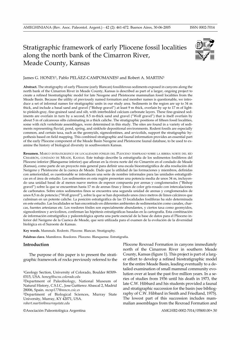
Figure 1. Topographic map showing locations of measured sec-tions (numbers) and fossil sites (letters) along the north bank ofthe Cimarron River, Meade County, Kansas. Keefe and FoxCanyons are official names shown on the Kismet SE 7.5 min.quadrangle, Kansas-Oklahoma, whereas Alien, East of Alien(EOA) and Fractal Canyons are informal names we have appliedto unnamed canyons in the same region. Position of Keefe Canyonon this map differs from that on the Kismet SE quadrangle; seetext. Numbers 1-12 are measured sections shown in figures 2 and3 and described in Appendix I. The positions of fossil localities notin measured sections are identified as follows: A= Raptor 4, 5; B=Raptor 3A-B; C= Raptor 4; D= Keefe Canyon Quarry (KC) ofHibbard and Riggs (1949); E= Wiens; F= Bishop; G= Ripley A, B;H= Vasquez; I= Newt; J= Fox Canyon locality (FC) of Hibbard(1950). Remaining fossil localities are located within measuredsections as follows: 3= KC Turtle; 6= Raptor 1A-C; 8= Red Fox;10= Taylor mollusk locality 4b. Bar scale in kilometers. Elevationis in feet / Mapa topográfico mostrando la localización de las seccionesmedidas (números) y sitios fosilíferos (letras) sobre la margen norte delrío Cimarrón, condado de Meade, Kansas. Los cañones de Keefe y Foxson nombres oficiales que figuran en el mapa Kismet SE 7,5 min.,Kansas-Oklahoma, mientras que los cañones Alien, este de Alien (EOA)y Fractal son nombres informales que hemos aplicado a cañones innom-inados de la misma región. La posición del cañón de Keefe en este mapadifiere de la del mapa Kismet SE; véase texto. Los números 1-12 son sec-ciones medidas mostradas en las figuras 2 y 3 y descriptas en el apéndiceI. La posición de las localidades fosilíferas no situadas en secciones medi-das se identifica así: A= Raptor 4, 5; B= Raptor 3A-B; C= Raptor 4; D=Keefe Canyon Quarry (KC) of Hibbard and Riggs (1949); E= Wiens; F=Bishop; G= Ripley A, B; H= Vasquez; I= Newt; J= Fox Canyon locality(FC) of Hibbard (1950). El resto de las localidades fosilíferas se localizanen las secciones medidas como sigue: 3= KC Turtle; 6= Raptor 1A-C; 8=Red Fox; 10= Taylor mollusk locality 4b. Escala en kilómetros, altitud enpies.
Meade basin stratigraphy, Kansas 463
extending from the Oklahoma panhandle into south-western Kansas. The study area for this report is lo-cated in southern Meade County along the northbank of the Cimarron River in sections 34 and 35, T.34 S, R. 30 W and sections 2 and 3, T. 35 S, R. 30 W, inthe Kismet SE 7 1/2 minute quadrangle (figure 1).This area includes a series of canyons, which fromwest to east include Keefe, Alien, East of Alien(EOA), Fractal, and Fox. Keefe and Fox Canyons ap-pear on the USGS Kismet SE quadrangle, whereasthe others are informal names we have applied to un-named canyons. Detailed descriptions of measuredsections can be found in Appendix I, and measuredsection locations are shown in figure 1.
Our measured sections comprise a total thicknessof 34 m of Pliocene sediments north of the CimarronRiver. These sediments consist of light- to pinkish-gray, fine-grained sandstones and siltstones, lightyellowish-gray sands and gravels, and scattered grayto white calcium carbonate layers. The fine-grainedsandstones and siltstones commonly contain calcare-ous stringers and nodules that locally form indurat-ed ledges. Some siltstones and fine sandstones aremassive, and may in part be eolian; other silty sands,however, contain scattered medium- to coarse-grained lenses, rip-up clasts, and traces of cross-bed-ding or ripple lamination that together indicate a flu-vial origin. Coarse-grained sand and gravel units arefluvial in origin. They vary from unconsolidated toindurated (due to calcium carbonate cementation),even within the same unit. Indurated sands andgravels may form strongly cross-bedded ledges thatare traceable for several kilometers. Massive calciumcarbonate layers with abundant root traces are inter-preted to be pedogenic calcareous accumulations;some show evidence of having formed from theamalgamation of carbonate nodules and stringers.Other massive calcium carbonate layers locally con-tain charophytes and mollusks, and are thought torepresent ponds. North of the Cimarron River, sever-al calcium carbonate layers are identifiable and trace-able through several canyons.
Locally along the Cimarron River the base of thePliocene section is exposed and overlies rocks re-ferred to the Laverne Formation (Frye and Hibbard,1941; Byrne and McLaughlin, 1948). A major sandand gravel unit in the upper part of the Pliocene sec-tion has been called the Meade Gravels Member(Hibbard, 1949). Later, the name Angell Member (ofthe Ballard Formation) was introduced as a substi-tute for the Meade Gravels Member (Hibbard, 1958).Our preliminary stratigraphic work indicates thatboth the names Meade Gravels Member and AngellMember have been applied to more than one gravelunit, and therefore in this report we introduce “Wolfgravels” as an informal name for the gravels former-
ly called Meade in Fox and Keefe Canyons. The nameWolf gravels is taken from Wolf Canyon in south-western Meade County, where these gravels are wellexposed. In the canyons north of the Cimarron River,the Wolf sands and gravels, which can be traced be-tween the canyons, vary from completely unconsoli-dated to lithified and strongly cross-bedded.
Fossil localities and vertebrate assemblages
Fossiliferous localities have been found in Keefe,Alien, EOA, and Fox Canyons. Preliminary lists ofthe rodents are provided in table 1; only those taxathat aid in correlation are included. Detailed studiesare currently in preparation, and it is to be expectedthat some of the nomenclature will change as a re-sult. Localities discussed in the text are listed below,with the following abbreviations: S = small mam-mals; L = large mammals; MSU = Murray StateUniversity locality number.
Keefe Canyon:
Raptor 1A-C (MSU-10-98; three superposed levels; S, L).Raptor 2 (MSU-11-98; L).Raptor 3A-B (MSU-12-98; two superposed levels; S, L).Raptor 4, 5 (MSU-15-98; two localities that probably represent thesame sampling level, on either side of a ridge; S).KC Turtle (MSU-2-99; S).KC (KU Loc. 22; Hibbard and Riggs [1949] original quarry locali-ty; S, L).KCN (MSU-2-98; ca. 5.0 m north of KC; L).
Alien Canyon:
Wiens A-D (MSU 1-98; four superposed levels; S, L).
East of Alien Canyon:
Bishop (MSU-4-99; L).Ripley A-B (MSU-7-99; two superposed levels; S, L).Camel Pod (MSU-5-99; L).Vasquez/Newt (MSU-19-99/MSU-6-99; two localities ca. 10.0 mapart; probably once connected; S, L).
Fox Canyon
Fox Canyon (UM-K1-47 = Rexroad Loc. 6; Hibbard [1950] originallocality; S, L).Red Fox (MSU-16-00; S).Taylor 4b (one of D. W. Taylor [1960, 1966] mollusk localities).
Keefe Canyon, as used in Hibbard and Riggs(1949) and in this paper, runs north-south and ex-tends through the SW1/4, sec. 34, T. 34 S., R. 30 W.and the NW1/4 sec. 3, T. 35 S., R. 30 W., MeadeCounty, Kansas. Local residents have pointed out tous the remains of the “dugout” in which the originalMr. Keefe resided, located south of the original KeefeCanyon quarry (KU Loc. 22; Hibbard and Riggs,1949), near the mouth of the canyon. We mention this
AMEGHINIANA 42 (2), 2005
J.G. Honey, P. Peláez-Campomanes and R.A. Martin464
detail because the canyon labeled as Keefe Canyonon the USGS Kismet SE 7 1/2 minute quadrangle isactually the canyon to the west of that which containsHibbard and Riggs’ quarry (KC) and the dugout.Also, the footages relative to section corners given byTaylor (1966) for the location of the KC quarry are in-correct, and place the quarry in the canyon labeled as“Keefe” on the 7 1/2 minute map. Mr. Spencer Wiensof Meade first took us to the KC quarry, which wasimmediately recognizable by comparisons with pho-tographs in Hibbard and Riggs (1949). Some of ournew fossil sites and measured sections and Hibbardand Riggs’ Keefe Canyon fossil quarry are located inthe canyon with the dugout (figure 2).
In their 1949 paper, Hibbard and Riggs concludedthat the fossil deposit at KU Loc. 22 represented anold artesian spring basin. The fossils were recoveredfrom a lenticular “flour sand” horizon (maximumthickness of 1 meter) fed by a vertical sand-filledtube. The deposit may have been completely minedout by Hibbard and associates, since we found no ev-idence of the sand-filled tube or the flour sand hori-zon at the quarry. Instead, we found bone fragmentsin a 1.45 m interval within fine-grained silty sand-stones (figure 2, section 2, KCN) in the walls of thewash 5.0 m north of KC, at what we believe to be thestratigraphic position of KC. Washing of test samplesfrom this 1.45 m interval yielded no identifiable spec-imens, but two Equus molars were recovered in situin summer 2002.
Among several new localities found in KeefeCanyon is one, Raptor 3, that has an unusual litholo-gy. Bones of large mammals and rodent teeth arefound in an area where the basal calcium carbonatelayer is fractured and has collapsed, with selenitecrystals and plates filling the fractures. The bones arepartly covered with selenite. This locality probablyrepresents an old spring, with mineralized waterslikely derived from the solution of underlying Pa-leozoic evaporites. A well (Stanolind Oil and GasCompany, A.W. Adams No. 1) drilled 4.57 km south-west of Raptor 3 in the SW corner of SW 1/4 sec. 8, T.35 S., R. 30 W., intersected gypsiferous and anhy-drite-bearing rocks of the Paleozoic Nippewalla andSumner Groups. For example, a 22 m thick gypsumbed is present in the Flowerpot Shale in this well(Lee, 1953). Raptor 3 is subdivided into two super-posed levels, a lower A unit and an upper B unit.Raptor 3A produced the microfauna reported inTable 1.
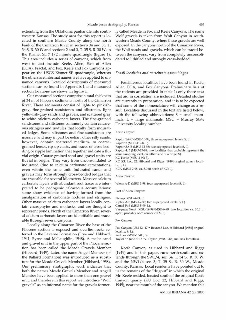
In Fox Canyon (figure 3), we located a sandy hori-zon that appears to be the source of Hibbard’s (1950)Fox Canyon l.f. Large and small mammal bones arecommonly found in a two meter thick sand, the topof which is 6.5 m topographically below a massivecaliche (our CC1 in figure 3) that caps the exposure.
We sampled the unit at this level and recoveredPliophenacomys finneyi, an extinct arvicoline rodentthat characterizes the Fox Canyon local fauna.However, Hibbard (1950) noted that most of hisspecimens were recovered from a pocket of sandysilts that grade laterally into channel sands 5.18 m be-
AMEGHINIANA 42 (2), 2005
SciuridaePaenemarmota barbouri(Hibbard and Schultz, 1948) x x xGeomyidaeGeomys cf quinni(McGrew, 1944) x x xGeomys minor([Gidley], 1922) x x x x x x x x xGeomys adamsi(Hibbard, 1967) x
SigmodontinaeBensonomys eliasi([Hibbard], 1938) x x x x x x x xBensonomys sp. x xSymmetrodontomys simplicidens (Hibbard, 1941a) x x x x x cf x x x xBaiomys rexroadi(Hibbard, 1941a) x x x x cf x x x xOnychomys gidleyi(Hibbard, 1941b) xOnychomys sp. x x x x x xReithrodontomys wetmorei(Hibbard, 1952) x x xPeromyscus baumgartneri(Hibbard, 1954) x Peromyscus sp. x xNeotoma quadriplicata([Hibbard], 1941a) x x x x x x xSigmodon minor (archaic)(Gidley, 1922) xSigmodon holocuspis(Czaplewski, 1987) x x
ArvicolidaeOgmodontomys poaphagus(Hibbard, 1941a) x x x x x x x x x xPliophenacomys finneyi(Hibbard and Zakrzewski, 1972)x
ZapodidaeZapus rinkeri (Hibbard, 1951) x Zapus sandersi (Hibbard, 1956) x
Fox
Can
yon
Red
Fox
Ripl
ey B
Kee
fe C
anyo
nRa
ptor
1C
Kee
fe C
. Tur
tleW
iens
BV
asqu
ez/N
ewt
Rapt
or 3
ARa
ptor
4,5
Table 1. Rodent species recovered from fossil localities along thenorth bank of the Cimarron River, Meade County, Kansas /Especies de roedores encontrados en las localidades fosilíferas a lo largo dela ribera norte del río Cimarrón, condado de Meade, Kansas.
Meade basin stratigraphy, Kansas 465
low CC1 (Hibbard’s locality UM-K1-47). The top ofthe sandy horizon to the north across the wash fromUM-K1-47 is 5.30 m below CC1; the difference be-tween Hibbard’s and our measurements at the origi-nal quarry is due to a massive slumping of sedimentsat the quarry since Hibbard’s measurements weretaken. Our measured section in figure 3 (Fox CanyonW.) is a composite, with the lower part (CC1 and be-low) taken roughly 50 m west of the fossil quarry,and the upper portion (above CC1) measured direct-ly above the fossil quarry.
Correlations
In the following section we describe stratigraphiccorrelations based on tracing various marker units,such as calcium carbonate layers and gravels. Faunalevidence is provided for support where appropriate,but is never the primary source of correlation.Twelve stratigraphic sections were measured be-tween Keefe and Fox Canyons using a Jacob’s staff
and tape; corrections for dip of the rocks were ap-plied where warranted. The stratigraphic sequencein this area is characterized by a lower, thick sandand gravel unit locally at least 9.0 m thick that is usu-ally consolidated and cross-bedded near its top. Wecall this unit informally the “Bishop gravel,” namedafter a large mammal locality associated with thishorizon in EOA Canyon. A second sand and gravelunit, the Wolf gravel, is located approximately 13.5-17.0 m above the Bishop gravel. It is mostly uncon-solidated, with some consolidated and cross-beddedledges at various levels. Between these two gravelswe recognize three calcium carbonate layers: (1) alower massive white layer (unit CC1), with charo-phytes and ostracods visible in its upper half in somehand samples, (2) a middle, grayish, pitted layer,which contains root traces but no charophytes (unitCC2), and (3) an upper layer that where well exposedmay be expressed as wavy carbonate stringers ofvarying thickness, associated with mudstones in thedevelopment of vertisol structure, or as isolated car-bonate nodules in poor exposures (unit CC3). These
AMEGHINIANA 42 (2), 2005
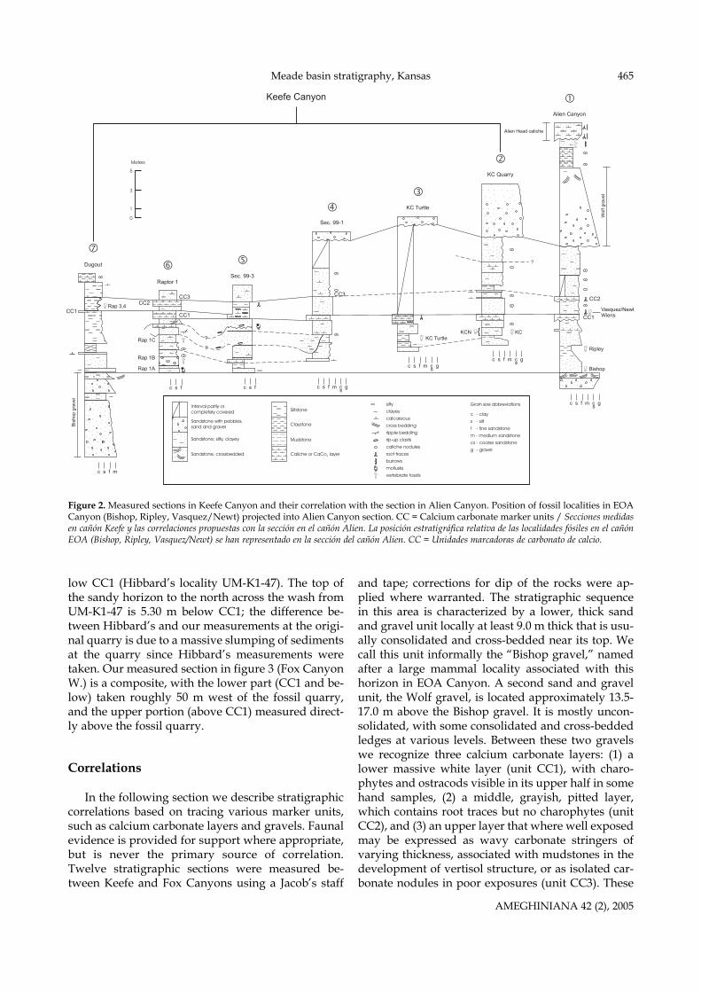
Figure 2. Measured sections in Keefe Canyon and their correlation with the section in Alien Canyon. Position of fossil localities in EOACanyon (Bishop, Ripley, Vasquez/Newt) projected into Alien Canyon section. CC = Calcium carbonate marker units / Secciones medidasen cañón Keefe y las correlaciones propuestas con la sección en el cañón Alien. La posición estratigráfica relativa de las localidades fósiles en el cañónEOA (Bishop, Ripley, Vasquez/Newt) se han representado en la sección del cañón Alien. CC = Unidades marcadoras de carbonato de calcio.
?
?
?
Wol
f gra
vel
Alien Head caliche
Bis
hop
grav
el
CC1Rap 3,4
Rap 1C KC TurtleKCN KC
Ripley
Bishop
Vasquez/NewtWiens
Rap 1B
Rap 1A
CC1
CC3CC2
{
CC1
CC2
Dugout
Raptor 1Sec. 99-3
Keefe Canyon
Sec. 99-1
KC Turtle
KC Quarry
Alien Canyon
CC3
Fig. 2
c s f m c g s
c s f m c g sc s f m c g
s
c s f m c g sc s fc s f
c s f m
Meters
5
3
1
0
Grain size abbreviations
c - clay
s - silt
f - fine sandstone
m - medium sandstone
cs - coarse sandstone
g - gravel
silty
clayey
calcareous
cross bedding
ripple bedding
rip-up clasts
caliche nodules
root tracesburrows
mollusks
vertebrate fossils
Siltstone
Claystone
Mudstone
Caliche or CaCo layer3
Interval partly or completely covered
Sandstone with pebbles,sand and gravel
Sandstone; silty, clayey
Sandstone, crossbedded
J.G. Honey, P. Peláez-Campomanes and R.A. Martin466
units may vary locally in thickness and in appear-ance. Finally, a 2.0 m thick calcium carbonate layer,informally called the “Alien Head caliche,” is present3.0 m above the Wolf gravel. The name derives fromthe similarity of the caliche caprock at the head ofAlien Canyon to the head of the monster by the samename in the movie Alien (fossil quarries and somegullies in EOA Canyon are named after characters inthe Alien movie series [Martin et al., 2000]). Below, wedescribe stratigraphic correlations in the five majorcanyons in our study area, moving from west to east,beginning with Keefe and ending with Fox Canyon.
We measured six sections in Keefe Canyon (figure2). The Bishop gravel crops out in the southern mostmeasured section (Dugout section; section 7), wherethe canyon is most deeply cut. Higher in section 7 isCC1, which is traceable up canyon as a prominentwhite ledge through the six measured sections. It isour primary correlational unit in Keefe Canyon.When sediments are well exposed immediately aboveCC1, large mammal fossils are usually present. Threefossil localities in Keefe Canyon represent this hori-zon (Raptor 3-5). CC1 is the same unit as the massivecaliche 2.0 m above KU Loc. 22 (KC) described byHibbard and Riggs (1949). In Keefe Canyon there arethree fossil localities at this distance below CC1; KC(figure 2, section 2), KC Turtle (figure 2, section 3),and Raptor 1C (figure 2, section 6). A mollusk zone atleast 0.3 m thick, Raptor 1A, is present in silty sands2.4 m below the Raptor 1C level, the same distance asHibbard and Riggs (1949, p. 833) reported for a mol-lusk zone below KC. This stratigraphic correlation isfurther supported by the record of Sigmodon holocus-pis, a primitive sigmodontine rodent, from bothRaptor 1C and KC. Good exposures of sediments be-tween the Bishop gravel and CC1 show lateral facieschanges interpreted as cross-cutting channels andtheir associated overbank deposits. Near KC (figure 2,section 2), 8.3 to 8.8 m of sandstone, siltstones, andcalcium carbonate layers separate CC1 from the over-lying Wolf gravel. CC2 and CC3 are found in this in-terval. Unit CC3 is well-exposed at the top of mea-sured sections 4-6 (figure 2) as a distinctive, pale or-ange-brown siltstone and silty sandstone containingthin, undulating layers of calcium carbonate nodulesand stringers interpreted as a vertisol.
Correlations of units between the localities inKeefe Canyon and those in the canyons to the eastare established by following units CC1, CC2, andCC3 across the divide on the south side of TableMesa, in NE1/4, SE1/4, NW1/4 sec. 3, T. 35 S., R. 30W. Correlations have also been established by fol-lowing the Wolf gravel unit north of Table Mesa. Asin Keefe Canyon, we found both scattered largemammal bone and quarryable concentrations ofbone (the rich Wiens locality) in Alien Canyon in sed-
iments directly above CC1. East of the Wiens locality,CC1 and CC2 are visible as a couplet that can betraced across the hill-slopes, through Alien Canyon,and into the succession of localities in EOA Canyon.Measured section 1 (figure 2) is from Alien Canyon,and also includes the measured levels of the new fos-sil localities in EOA Canyon. The section in AlienCanyon is the most complete that we have foundnorth of the Cimarron River. Due to a 2° to 3° dip ofPliocene sediments toward the river in Alien andEOA Canyons, erosion does not penetrate into thelower portions of the sediments, even in the lowerreaches of the canyons. The lowest fossil level isBishop, a large mammal site in mudstones immedi-ately on top of the Bishop gravel. Lateral to theBishop fossil site the underlying sand and gravel iscross-bedded, but immediately beneath the site thesandstone is convoluted. This disturbed beddingmay have been the result of bioturbation by animals,or due to water escape at the site of an ancient spring.Support for the latter idea is found at the Camel Podlocality in this canyon about 100 m east of Bishop.Here, lenticular masses of highly calcareous sand-stone, some with mammal bones, are connected bythree dikes to the sand and gravel unit underlyingBishop. We believe that these dikes represent theconduits to a spring, and that the sand filling thesedikes was injected from the underlying sand andgravel unit.
Ripley A, located 2.2 m above the Bishop gravel,is a light greenish-gray, fine-grained silty sandstonecontaining mollusks. Ripley B, a dark grayish-brown,organic-rich sandstone and siltstone, containingabundant large mammal bones and rodent teeth, isdeveloped directly above Ripley A. Both units likelyrepresent a pond deposit. The top of the Ripley Alevel is 2.8 m below CC1 (figure 3; measured section1), compared to a distance of 1.8 m below CC1 forRaptor 1C in Keefe Canyon. The inferred strati-graphic position of Ripley B below Raptor 1C is indi-rectly substantiated by comparison of cotton ratspecimens from Raptor 1C, Ripley B, and the HouseMountain locality of the Verde l.f, the type locality ofSigmodon holocuspis. Both S. holocuspis and S. minorwere recorded by Czaplewski (1987) from HouseMountain. The cotton rat from Ripley B represents amore primitive morphological grade of S. minor thanthat from House Mountain (Peláez-Campomanesand Martin, in preparation), whereas Raptor 1C hasonly S. holocuspis, and is therefore tentatively corre-lated with House Mountain.
Two rich micromammal localities, Vasquez andNewt, lie between CC1 and CC2 near the head ofEOA Canyon. The eastern edge of deposits that pro-duced the Vasquez l.f. is separated by a small gullyfrom the western edge of the locality producing the
AMEGHINIANA 42 (2), 2005
Meade basin stratigraphy, Kansas 467
Newt l.f. It is highly probable that the two were onceconnected, and therefore represent the same sam-pling interval. These localities are at the same gener-al stratigraphic level as Wiens (in Alien Canyon) andRaptor 3-5 (in Keefe Canyon).
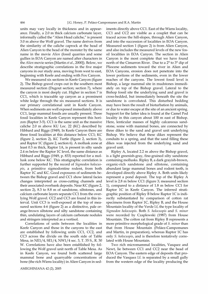
In Alien Canyon 5.4 m of grayish-orange silt-stones and fine-grained silty sandstones containinglocal concentrations of carbonate nodules and strin-gers are located between CC2 and the Wolf gravel;this interval is partly equivalent to unit CC3 in KeefeCanyon. The section is capped by a 1.8 m cliff-form-ing caliche containing abundant root traces andprobable burrows that forms the upland surface justnorth of the river.
Tracing of beds between Fox Canyon and EOACanyon is hampered by extensive cover and thepresence of a collapse basin in section 2, T. 35 S., R. 30W. This collapse explains the southward dip ofPliocene sediments toward the Cimarron River inFox Canyon and in the EOA Canyon area. Fortu-nately, an outcrop in a small canyon (Fractal Canyon;figure 3, section 12) situated between Fox and EOA
Canyons, in the SW1/4 sec. 35, T. 34 S., R. 30 W, ap-pears to provide the necessary connection. A promi-nent 0.55-1.2 m thick ledge of interbedded wavy car-bonate and silty sandstone is found there, the top ofwhich is 5.3 m below the Wolf gravel. The formerunit is lithologically similar to unit CC3 in KeefeCanyon, and the base of both units (figures 2, 3; mea-sured sections 12 and 4) are nearly the same distancebelow the Wolf gravel, differing only by about 0.5 m.Therefore, we tentatively conclude that the units areequivalent.
The Fox Canyon locality of Hibbard (1950) is 1.56km northeast of the EOA localities. Four sectionswere measured in Fox Canyon (figure 3, sections 8-11). Section 11 was measured about 50 m upstreamfrom Hibbard’s Fox Canyon locality (UM-K1-47).About 7.0 m below the base of the Wolf gravel atmeasured section 11 and 10.5 m below the Wolf grav-el at section 8 is a prominent caliche that forms awhite band across the hillsides in this area. Locally itforms a massive bench showing root traces. Hibbard(1950: p. 120) reported this caliche to be 6.7 m below
AMEGHINIANA 42 (2), 2005
CC1
Wol
f gra
vel
CC3Modern Soil
c s f m c g s
c s f
c s f m c g s
Alien Canyon
Fractal Canyon
Taylor molluskloc. 4b
c s f m
Taylor
Gas Well
Red Fox
Red Fox
Alien Head caliche
CC2
CC1
Ripley
Vasquez/NewtWiens
Meters5
3
1
0
Fox Canyon
c s f m c g s
Bishop
Fox Canyon
gray claystoneBishop gravel
CC1
c s f m c g s
Fox Canyon W.
CC3
Figure 3. Measured sections and correlations in Fox, Fractal, and Alien Canyons / Secciones medidas y correlaciones propuestas entre loscañones Fox, Fractal y Alien.
J.G. Honey, P. Peláez-Campomanes and R.A. Martin468
the “Meade Gravels” at the Fox Canyon quarry, andbelieved that this “massive caliche zone” was thesame as the caliche 2.0 m above UK loc. 22 (unit CC1in figure 2). He compared the stratigraphic distancesof his Fox Canyon and KC sites below these (as-sumed equivalent) caliches, and concluded that theFox Canyon site was slightly lower stratigraphicallythan the KC quarry. Our correlations generally sup-port this interpretation.
The Red Fox mammal locality (figure 3, section8) is 3.0 m below CC1, and correlates stratigraphi-cally to D. W. Taylor’s mollusk locality 4b (Taylor,1960; = Rexroad loc. 15 of Taylor, 1966) (figure 3,section 10). Using CC1 as a marker unit, these lo-
calities are stratigraphically higher than Hibbard’sFox Canyon locality, and may represent the samestratigraphic level that produced the Ripley l.f. inEOA Canyon (figure 3, section 1). Although the col-lection of rodent molars from Red Fox is small, theabsence of Pliophenacomys finneyi, a common rodentfrom Hibbard’s Fox Canyon locality, further sug-gests a chronological difference from Hibbard’ssite.
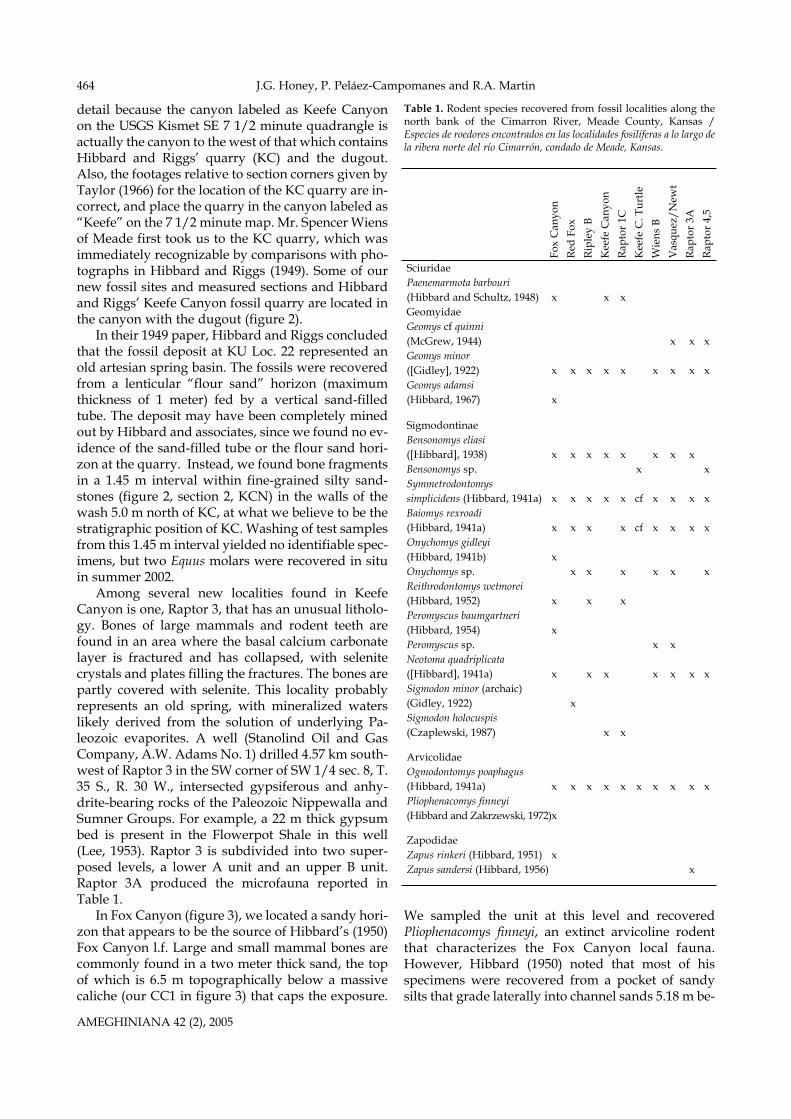
Synthesis and conclusions
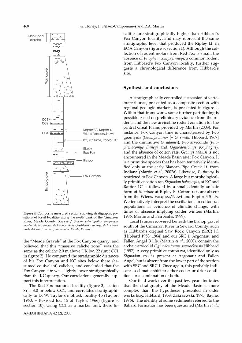
A stratigraphically controlled succession of verte-brate faunas, presented as a composite section withregional geologic markers, is presented in figure 4.Within that framework, some further partitioning ispossible based on preliminary evidence from the ro-dents and the new arvicoline rodent zonation for thecentral Great Plains provided by Martin (2003). Forinstance, Fox Canyon time is characterized by twogeomyids (Geomys minor [= G. smithi Hibbard, 1967]and the diminutive G. adamsi), two arvicolids (Plio-phenacomys finneyi and Ogmodontomys poaphagus),and the absence of cotton rats. Geomys adamsi is notencountered in the Meade Basin after Fox Canyon. Itis a primitive species that has been tentatively identi-fied only at the early Blancan Pipe Creek l.f. fromIndiana (Martin et al., 2002a). Likewise, P. finneyi isrestricted to Fox Canyon. A large but morphological-ly primitive cotton rat, Sigmodon holocuspis, at KC andRaptor 1C is followed by a small, dentally archaicform of S. minor at Ripley B. Cotton rats are absentfrom the Wiens, Vasquez/Newt and Raptor 3-5 l.fs.We tentatively interpret the oscillations in cotton ratpopulations as evidence of climatic change, withtimes of absence implying colder winters (Martin,1986; Martin and Fairbanks, 1999).
Local faunas recovered beneath the Bishop gravelsouth of the Cimarron River in Seward County, suchas Hibbard’s original Saw Rock Canyon (SRC) l.f.(Hibbard 1953; 1964) and our SRC 1, Argonaut, andFallen Angel B l.fs. (Martin et al., 2000), contain thearchaic arvicolid Ogmodontomys sawrockensis Hibbard(1957). A very primitive cotton rat, identified only asSigmodon sp., is present at Argonaut and FallenAngel, but is absent from the lower part of the sectionwith SRC and SRC 1. Once again, this probably indi-cates a climatic shift to either cooler or drier condi-tions or a combination of both.
Our field work over the past few years indicatesthat the stratigraphy of the Meade Basin is morecomplex than the hypotheses presented in olderworks (e.g., Hibbard, 1958; Zakrzewski, 1975; Bayne,1976). The identity of some sediments referred to theBallard Formation has been questioned (Martin et al.,
AMEGHINIANA 42 (2), 2005
Bish
op
gra
vel
Wo
lf g
rave
l
Alien Headclaiche
CC2CC3
CC1Raptor 3A, Raptor 4,Wiens, Vasquez/Newt
RipleyRed Fox
Bishop
Fox Canyon
KC, KC Turtle, Raptor 1C
Figure 4. Composite measured section showing stratigraphic po-sitions of fossil localities along the north bank of the CimarronRiver, Meade County, Kansas / Sección estratigráfica compuestamostrando la posición de las localidades fosilíferas a lo largo de la riberanorte del río Cimarrón, condado de Meade, Kansas.
Meade basin stratigraphy, Kansas 469
2002b), and we do not currently recognize this for-mation except at the type locality on the Big SpringsRanch, which is not accessible to scientists. It is alsoproblematic to extend use of the Rexroad Formationsouth from its type locality near Meade State Park tothe north bank of the Cimarron River, and until somethorny problems are resolved in the type area, we re-frain from doing so. There are a number of Blancangravel units in Meade County, at different strati-graphic levels, that have been miscorrelated in thepast; we therefore choose to introduce the informalWolf and Bishop gravels for those in southern MeadeCounty simply to avoid confusion. Fortunately, inthe Cimarron River area the Bishop and Wolf gravelsand a series of caliche units (CC1, CC2, CC3) can befollowed through the canyons and used effectively asstratigraphic markers.
Acknowledgments
It is our pleasure to acknowledge J. and P. Adams and W. Fox,Jr., who own the land on which we worked. Their families have as-sisted in paleontological research in Meade County for almost 70years, and we are extremely grateful for their enthusiastic cooper-ation. D. Porter and R. Zakrzewski contributed their expertise inthe field, and we also thank the many university students whohave been associated with the project. G. Gunnell, P. Gingerichand L. Martin allowed study of critical museum specimens. Theirhospitality is much appreciated. This research was supported byNational Geographic Society grants 5963-97 and 6547-99 andNational Science Foundation grant EAR-0207582, with matchingfunds from MSU.
References
Bayne, C.K. 1976. Early and medial Pleistocene faunas of Meadecounty, Kansas. In: C.K. Bayne (ed.), Guidebook 24º annual meet-ing Midwestern friends of the Pleistocene. Kansas GeologicalSurvey, Lawrence, Guidebook Series 1, pp. 1-25.
Byrne, F.E. and McLaughlin, T.G. 1948. Geology and ground-wa-ter resources of Seward County, Kansas. State GeologicalSurvey of Kansas, Bulletin 69: 1-140.
Czaplewski, N.J. 1987. Sigmodont rodents (Mammalia; Muroidea;Sigmodontinae) from the Pliocene (early Blancan) VerdeFormation, Arizona. Journal of Vertebrate Paleontology 7: 183-199.
Frye, J.C. and Hibbard, C.W. 1941. Pliocene and Pleistocenestratigraphy and paleontology of the Meade Basin, south-western Kansas. State Geological Survey of Kansas, Bulletin 38:389-424.
Gidley, J.W. 1922. Preliminary report on fossil vertebrates of theSan Pedro Valley, Arizona, with descriptions of new species ofRodentia and Lagomorpha. U. S. Geological Survey ProfessionalPaper 131: 119-131.
Hibbard, C.W. 1938. An Upper Pliocene fauna from MeadeCounty, Kansas. Transactions Kansas Academy of Sciences 40:239-265.
Hibbard, C.W. 1941a. New mammals from the Rexroad fauna,Upper Pliocene of Kansas. American Midland Naturalist 26: 337-368.
Hibbard, C.W. 1941b. Mammals of the Rexroad fauna from the
Upper Pliocene of southwestern Kansas. Transactions KansasAcademy of Sciences 44: 265-313.
Hibbard, C.W. 1949. Pleistocene stratigraphy and paleontology ofMeade County, Kansas. Contributions from the Museum ofPaleontology, University of Michigan 7: 63-90.
Hibbard, C.W. 1950. Mammals of the Rexroad Formation fromFox Canyon, Meade County, Kansas. Contributions from theMuseum of Paleontology, University of Michigan 8: 113-192.
Hibbard, C.W. 1951. A new jumping mouse from the UpperPliocene of Kansas. Journal of Mammalogy 32: 351-352.
Hibbard, C.A. 1952. A contribution to the Rexroad fauna.Transactions Kansas Academy of Sciences 55: 196-208.
Hibbard, C.W. 1953. The Saw Rock Canyon fauna and its strati-graphic significance. Papers Michigan Academy Science, Arts,and Letters 38: 387-411.
Hibbard, C.W. 1954. Second contribution of the Rexroad fauna.Transactions Kansas Academy of Sciences 57: 221-237.
Hibbard, C.W. 1956. Vertebrate fossils from the Meade Formationof southwestern Kansas. Papers Michigan Academy Science, Artsand Letters 41: 145-203.
Hibbard, C.W. 1957. Two new Cenozoic microtine rodents.Journal of Mammalogy 38: 39-44.
Hibbard, C.W. 1958. New stratigraphic names for early Pleis-tocene deposits in southwestern Kansas. American Journal ofScience 256: 54-59.
Hibbard, C.W. 1964. A contribution to the Saw Rock Canyon localfauna of Kansas. Papers Michigan Academy of Science, Arts, andLetters 49: 115-127.
Hibbard, C.W. 1967. New rodents from the late Cenozoic ofKansas. Papers Michigan Academy of Science, Arts, and Letters 52:115-131.
Hibbard, C.W. and Riggs, E.S. 1949. Upper Pliocene vertebratesfrom Keefe Canyon, Meade County, Kansas. Bulletin of theGeological Society of America 60: 829-860.
Hibbard, C.W. and Schultz, C.B. 1948. A new sciurid of Blancanage from Kansas and Nebraska. Bulletin Nebraska StateMuseum 3: 19-29.
Hibbard, C.W. and Zakrzewski, R.J. 1972. A new species of mi-crotine from the late Pliocene of Kansas. Journal of Mammalogy53: 834-839.
Lee, W. 1953. Subsurface geologic cross section from MeadeCounty to Smith County, Kansas. State Geological Survey ofKansas, Oil and Gas Investigations 9: 1-23.
Martin, R.A. 1986. Energy, ecology, and cotton rat evolution.Paleobiology 12: 370-382.
Martin, R.A. 2003. Biochronology of latest Miocene throughPleistocene arvicolid rodents from the central Great Plains ofNorth America. Coloquios de Paleontologia, Volumen extraordi-nario 1: 373-383.
Martin, R.A. and Fairbanks, K.B. 1999. Cohesion and survivorshipof a rodent community during the past 4 million years insouthwestern Kansas. Evolutionary Ecology Research 1: 21-48.
Martin, R.A., Honey, J.G. and Peláez-Campomanes, P. 2000. TheMeade Basin rodent project: a progress report. Paludicola 3: 1-32.
Martin, RA., Goodwin, H.T. and Farlow, J.O. 2002a. Late Neogene(late Hemphillian) rodents from the Pipe Creek Sinkhole,Grant County, Illinois. Journal of Vertebrate Paleontology 22:137-151.
Martin, R.A., Honey, J.G., Peláez-Campomanes, P., Goodwin,H.T., Baskin, J.A. and Zakrzewski, R.J. 2002b. Blancan lago-morphs and rodents of the Deer Park assemblages, MeadeCounty, Kansas. Journal of Paleontology 76: 1072-1090.
McGrew, P.O. 1944. An early Pleistocene (Blancan) fauna fromNebraska. Geological Series Field Museum of Natural History 9:33-66.
Smith, G.R. and Friedland, N.E. 1975. Studies on Cenozoic pale-ontology and stratigraphy in honor of Claude W. Hibbard.University of Michigan Papers on Paleontology 12: 1-143.
Taylor, D.W. 1960. Late Cenozoic molluscan faunas from the
AMEGHINIANA 42 (2), 2005
J.G. Honey, P. Peláez-Campomanes and R.A. Martin470
High Plains. U.S. Geological Survey Professional Paper 337: 1-94.
Taylor, D.W. 1966. Summary of North American Blancan nonma-rine mollusks. Malacologia 4: 1-172.
Zakrzewski, R.J. 1975. Pleistocene stratigraphy and paleontologyin western Kansas: the state of the art, 1974. In: G.R. Smith andN.E. Friedland (eds.), Studies on Cenozoic Paleontology and
Stratigraphy in Honor of Claude W. Hibbard. The University ofMichigan, Museum of Paleontology. Papers on Paleontology 12:121-128.
Recibido: 26 de diciembre de 2003.Aceptado: 20 de octubre de 2004.
AMEGHINIANA 42 (2), 2005
Appendix I
Measured Sections (thickness in meters)Measured Section 1: measured by J. Honey and P. Peláez-Cam-pomanes, 1998
Top of section 14. Indurated caprock: CaCO3 horizon in orange-brown, silty, fine-grained sandstone; rooted; burrowed; brecciated upper part; CaCO3becomes more massive upwards 1.30 13. CaCO3, massive, indurated; shows mudcracks and slickensides;burrowed; base of CaCO3 horizon convoluted, and thickness of unitvariable 0.61 12. Interbedded light brownish gray, clayey, very fine grained sand-stone and sandy claystone; calcareous; burrows and possible roots pre-sent; forms cliff. Unit variable in thickness 0.91 11. Claystone, light brownish gray, slightly sandy, interbedded withthin (= 3 cm) layers of diffuse and nodular CaCO3; claystone layers upto 0.23 m thick. Upper 0.46 m of unit with less CaCO3 2.07 10. Sandstone, very fine to fine-grained, slightly silty, lacks pebbles; fri-able; grades below into underlying unit as part of fining-upwardspackage 1.13 9. Sand and gravel, yellowish-gray, crossbedded, with pebbles up to 7cm long; unconsolidated. Pebbles decrease in size and sorting im-proves upwards. Blocks of cemented, crossbedded sand and gravel lo-cally present. Rare bone fragments present 7.28 8. Sandstone, pinkish- to orange-gray, very fine grained, clayey. Lowerhalf of unit with numerous CaCO3 nodules that form a prominentwhite, rubble slope; upper half of unit without nodules. Clay contentincreases in upper 0.61 m. Sharp top contact 3.14 7. Partly covered interval: sandstone, pinkish-gray, very fine grained,silty, massive; less silty in upper part; scattered CaCO3 nodules formrubble slope 2.23 6. CaCO3; light gray; contains root traces; forms ledge or rubble slope;up to 1.00 m thick laterally 0.40 5. Interbedded light greenish gray, very fine grained silty sandstoneand sandy siltstone in lower half of unit, dominantly pinkish-gray siltysandstone in upper half of unit. Vertical root traces locally present.CaCO3 nodules up to 0.15 m across found about 0.8 m up from base.Sharp top contact. Bones are found nearby at this level, and localityMSU-1-98 (Wiens) is in this unit 1.60 4. CaCO3, white, locally with charophytes; forms prominent ledge.Wavy base 0.61 3. Sandstone, containing two cycles of reddish-brown, silty sandstonefining upwards from fine- to very fine grained. A thin layer of CaCO3nodules is present 0.8 m up in unit and separates the two cycles.Lowest 0.8 m of unit locally shows low-angle crossbedding. Sharp topcontact 1.91 2. Sandstone, orange-gray, friable, grading upwards into light-graysilty claystone 3.731. Sandstone, light orange brown, medium- to coarse-grained and con-taining some pebbles and cobbles; mostly unconsolidated except forsome cemented, crossbedded ledges in upper part of unit; top 0.46 mof unit cemented and containing pebbles up to 2 cm long 1.68+Base of exposure Total measured section 28.60
Measured Section 2: measured between 6 and 18 m north of location ofUK fossil locality 22, by J. Honey and P. Peláez-Campomanes, 1998.
Top of section 14. Unconsolidated gravelly sandstone; same as units 9 and 10 of mea-sured section 1 5.7913. Silty sandstone, light grayish brown; chippy weathering; contains
CaCO3 mottling and scattered CaCO3 nodules. Sharp upper contact2.53 12. CaCO3 zone, with nodules in reddish-brown, silty, very finegrained sandstone matrix; forms white layer on slope 1.34 11. Sandstone, greenish-gray, very fine grained, silty, massive, withCaCO3 mottling 1.40 10. Claystone, reddish-brown, sandy 0.40 9. CaCO3 ledge, white 0.08 8. Light brownish gray, very fine grained silty sandstone and sandysiltstone; slightly blocky weathering; contains CaCO3 mottling andscattered nodules; massive. Forms gentle slope 0.76 7. CaCO3 layer, white, massive; irregular thickness 0.10 6. Sandstone, orange-brown, very fine to lower fine grained; massivewith scattered CaCO3 nodules and stringers 1.68 5. CaCO3 zone, variable thickness, consisting of nodules in a lightgreenish gray to brownish-gray silty, very fine grained sandstone ma-trix; contains three CaCO3 horizons, the thickest one at the base of theunit 0.91 4. Silty sandstone, light greenish gray, very fine grained, slightlyclayey; massive, with blocky weathering in places; contains scatteredCaCO3 nodules; gradational lower contact with unit 3. Lower half ofunit 4 included in Keefe Canyon layer C 0.46 3. Silty sandstone, dark brownish gray, very fine grained, slightlyclayey and organic. Contains bone (= Keefe Canyon layer C) 0.15 2. Sandstone, light greenish gray, very fine grained with scatteredmedium grains; massive; hard. Contains bone (= Keefe Canyon layerB). Gradational top and base of unit 0.61 1. Sandstone, brownish-orange, upper fine to lower medium grainedwith scattered lower coarse grains; silty; massive in lower 0.61 m. Finesupward to very fine or fine-grained, greenish-gray sandstone, and intop 0.10 m is a greenish-gray sandy claystone. Keefe Canyon layer A isfrom 0.61 m to 0.98 m above base of section 1.07Base of exposure Total measured section 17.28
Measured Section 3: measured by J. Honey and D. Porter, 1999.
Top of section11. Sand and gravel; not measured10. Covered interval 9.609. Indurated CaC03 caprock; abundant root holes and vertical tubes 1-10 mm across; undulating base 0.45 8. Mudstone, light brownish gray, containing very fine grains of sand;carbonaceous; calcareous 0.13 7. Silty mudstone, light medium gray, with scattered very fine grainsof sand; extremely calcareous, hard; relict root traces 0.33 6. Sandstone, lower very fine grained, silty. Upper half of unit showsclay content increasing upward. Top 0.23 m contains carbonaceous ma-terial and clay films, and shows orange mottling along root traces 1.13 5. Claystone, calcareous, with carbonate nodules up to at least 0.08 macross scattered throughout unit. Bottom 0.17 m contains more car-bonate nodules. Upper 0.36 m possibly pedogenically modified 0.52 4. Claystone, with orange mottling. Gradational top contact 0.30 3. Claystone, olive-green, slightly sandy, with scattered brownish-blackcarbonaceous streaks; massive. Contains some probable burrows.Contains bone in basal 0.08 m of unit. Grades into overlying unit 0.16 2. Claystone, pale brown, silty, slightly sandy; massive. Sharp top con-tact 0.47 1. Sandstone, light orange gray, very fine grained with scattered coarsegrains. Contains burrows filled with fine- to medium-grained sandyclay and soft masses of carbonate. Grades into overlying unit througha contact of one or two cm 0.23+Start near base of exposure Total measured section 13.32
Meade basin stratigraphy, Kansas 471
Measured Section 4: measured by J. Honey and D. Porter, 1999.
Top of section 7. Sand and gravel; same as units 9 and 10 of measured section 1 4.88Covered interval 3.02 6. Sandy mudstone, reddish-brown, with disseminated CaCO3 nod-ules and discontinuous ledges; probable vertisol 3.00 5. Sand, light reddish brown, silty, massive; forms cliff 2.06 4. Interbedded sandy CaCO3 and pale olive gray, silty sand, locally cal-careous; fossil root traces present. This unit correlates with lower partof unit 9 of measured section 5 0.53 3. Sandstone, reddish-brown, silty, massive; contains zone of carbonatenodules about 0.15 m thick starting 0.15 m above base of unit. Formsvertical cliff 1.652. Siltstone, reddish-brown, sandy; contains vertical cracks; locallytruncated by sands that may be related to the overlying cliff-formingsandstone 0.79 1. Sandstone, very fine grained, silty; contains thin, discontinuousCaCO3 interbeds up to 3 cm, and scattered root traces. Top of unit de-fined by a discontinuous CaCO3 ledge. Beds making up this unit con-verge from north to south over a distance of 18.3 m; appears to be offluvial origin ~1.67 Total measured section 17.6
Measured Section 5: measured by J. Honey and D. Porter, 1999.
Top of section 11. Sandstone, pale orange brown, very fine grained, silty, containsscattered CaCO3 layers and nodules up to 0.06 m in length; probablevertisol 1.98 10. Siltstone, light-gray, sandy, with disseminated CaCO3 nodules andscattered minute root traces; weakly ledge-forming at top. Grades intooverlying unit 0.419. Calcareous mudstone, very light gray, composed mainly of fusingCaCO3 nodules. Lower 0.41 m forms resistant CaCO3 ledge; top 0.79m shows upwards decrease in nodules 1.19 8. Sandstone, pale orange brown, very fine grained, quartzitic, slightlysilty; contains scattered CaCO3 nodules in local lenses; traces of low-an-gle crossbedding; CaCO3 rip-up clasts in basal 15 cm. Undulating lowercontact with up to 0.15 m relief. Thickness measurement taken on edgeof channel; in deepest part of channel, unit 10 is 3.05 m thick 0.76 7. Sandstone; orange-brown, very fine grained; traces of cross-laminae;scattered root traces; contains some mollusks 0.51 6. Sandstone, very fine grained, silty at top; concentrations of CaCO3rip-up clasts at base of unit; massive. Gradational top contact 1.50 5. Sandstone, pale orange brown, very fine grained, silty, faint traces ofbedding; discontinuous 0.05 m CaCO3 layer about 0.41 m above base;thin clay stringers and scattered carbonaceous material in upper partof unit. Sharp top contact 1.32 4. Sandstone, very fine grained, silty; contains some clay laminae anddisseminated CaCO3. Sharp top contact 0.25 3. CaCO3 layer, white, formed in silty clay; contains minor root traces.0.03 m thick clay layer present 0.18 m up from base of unit 0.28 2. Silty claystone, light-brown in lower 0.38 m, olive-green in upper0.27 m; contains scattered fine- to medium-grained sand; some smallburrows; upper 0.27 m with some carbonaceous stringers and increas-ingly calcareous. Gradational top contact 0.65 1. Sandstone, light-brown, very fine grained, silty, clayey 0.30+ Total measured section 9.15
Measured Section 6: measured by J. Honey and P. Peláez-Campomanes, 1998.
Top of section 13. Sandstone, orange-brown, silty; calcareous. Correlates with proba-ble vertisol (unit 11) in measured section 5 0.79 12. CaCO3 zone formed in silty, fine- to medium-grained sandstone;forms prominent white layer on outcrop 0.82 11. Sandstone, light brownish gray, mainly fine-grained, silty 0.49 10. CaCO3 zone, white, massive 0.89 9. Sandstone, orange-brown; fine- to medium-grained with lenses of
CaCO3 rip-up clasts in basal 0.13 m; small scale crossbedding present;upper part of unit very fine grained and silty. Unit measured near edgeof channel; in deepest part of channel, unit is about 1.83 m thick andshows superposed sets of crossbedding 0.61 8. CaCO3, white, massive. Eroded in center of outcrop by unit 9 0.18 7. Sandstone, light orange brown, very fine grained, silty, with a fewgreen clay layers up to 2.5 cm thick; ripple laminated; massive in top0.46 m. Locally, unit is coarser-grained at base. Sharp, undulating topcontact 0.99 6. Sandstone, light grayish green, very fine grained, silty, massive; top0.13 m of unit calcareous. Sharp top contact with up to 0.30 m relief.Unit thickens to 1.07 m laterally. Contains mammal fossils (localityMSU-10-98) 0.79 5. Unit consisting of 0.30 m thick basal zone of CaCO3 nodule forma-tion, with nodules up to 3 cm across. Upper 0.46 m of unit consists oflight greenish gray, very fine grained, silty sandstone containing onlyrare CaCO3 nodules; top several cm with scattered coarse grains ofsand. Sharp top contact 0.76 4. Unit consisting of 0.18 m thick basal zone of CaCO3 nodule forma-tion in a light olive gray, very fine grained, silty sandstone and sandysiltstone. Upper 0.61 m of unit shows columnar structure with CaCO3mottling, but without distinct CaCO3 horizons 0.81 3. Sandstone, light orange brown grading up to light olive gray; veryfine grained, slightly silty, massive; contains scattered CaCO3 nodulesforming discontinuous horizon in basal 0.30 m of unit. Top 0.25 m ofunit with scattered CaCO3 nodules and columnar structure. Mammalfossils taken from middle of unit 0.86 2. Sandstone, brownish-gray, very fine grained, silty, carbonaceous,containing rare, scattered mollusks. Grades up to light olive gray sand-stone with abundant mollusks and scattered CaCO3 nodules and mot-tling. Probably is part of Hibbard and Riggs’s (1949) gastropod-bearingunit 3 in their Keefe Canyon measured section 0.30 1. Sandstone, light yellowish to light olive gray, very fine to fine-grained, silty, with scattered mollusks; 1 cm thick CaCO3 layer at top.Probably part of Hibbard and Riggs’s (1949) unit 3 0.30+ Total measured section 8.59
Measured Section 7: measured by J. Honey and P. Peláez-Campomanes, 1998.
Top of section 14. CaCO3 zone, containing nodules and laminae in a clayey matrix;cementation increases upwards. Forms rubble bench 1.07 13. Interbedded clayey, very fine grained sandstone and siltstone, lightolive gray to light medium gray; contains 5.1 cm thick CaCO3 cement-ed zone 0.46 m from top of unit 1.52 12. Interbedded light olive gray sandy claystone and clayey sandstone 1.37 11. Interbedded fine-grained, silty sandstone and sandy siltstone in low-er 2/3 of unit, pinkish-brown to light medium gray; grades up to medi-um- to light brownish gray, sandy siltstone in top 1/3 of unit. Top 0.25m of unit is a CaCO3 zone consisting of partially fused nodules 3.56 10. Claystone, moderate yellowish brown 0.94 9. CaCO3 layer; forms thin bench 0.10 8. Sandstone, pinkish-brown, fine-grained, silty. About 0.76 m abovebase is a 5 cm thick CaCO3 mottled zone 1.68 7. Muddy sandstone, pinkish-brown, medium- to coarse-grained, withCaCO3 mottling; contains scattered pebbles; 2.5 cm thick CaCO3 layerat top of unit 0.38 6. Claystone, light olive gray with CaCO3 mottling. Sharp top contact 0.235. Sandstone, yellowish-gray, very fine to fine-grained, silty; containsscattered carbonaceous fragments and CaCO3 mottling. Gradationaltop contact 0.46 4. Sandstone, medium- to coarse-grained with a few thin silty andclayey laminae; crossbedding present, outlined by carbonaceous ma-terial. Locally forms cemented ledge 0.13 3. Sandstone, yellowish-orange, medium- to coarse-grained with scat-tered pebbles and cobbles. Fines up to fine- to lower medium grainedwith only a few pebbles. Gradational top contact 1.42 2. Sandstone, reddish-brown, fine-grained, clayey and silty; scatteredCaCO3 mottling. Sharp top contact 0.76 1. Sandstone, yellowish-gray, medium- to coarse-grained; contains peb-bles of white quartz, gray chert, and red granitic rock in lower part ofunit. Fines upward to fine- to medium-grained. Top of 20 cm thick, yel-
AMEGHINIANA 42 (2), 2005
J.G. Honey, P. Peláez-Campomanes and R.A. Martin472
low cemented ledge containing scattered pebbles, is present 0.53 mdown from top of unit. Top contact gradational; base not exposed 5.89+ Total measured section 19.51
Measured Section 8 (MSU-16-00): measured by J. Honey, P. Peláez-Campomanes, and R. Martin, 2001.
Top of section 14. Sand and gravel, unconsolidated; mostly covered 7.16 13. Sandstone, light-brown, very fine to fine-grained, slightly silty withCaCO3 mottling; strongly CaCO3 cemented in top 0.74 m 1.52 12. Partly covered interval consisting of very fine grained, silty sand-stone; contains CaCO3 nodules that decrease in abundance upwards.Sharp top contact 3.9911. Partly covered interval consisting of light-brown, very fine grainedsandy siltstone; contains abundant CaCO3 nodules and rubble thatforms white band across hillside. Gradational top contact 1.68 10. Mostly covered interval apparently consisting of pinkish-gray silt-stone 3.38 9. CaCO3 interval; upper 0.15 m more massive 0.84 8. Siltstone, pinkish-orange, sandy, with scattered thin layers and nod-ules of CaCO3 1.68 7. CaCO3 and siltstone; forms ledge 0.236. Siltstone, sandy 0.36 5. Siltstone; contains scattered CaCO3 nodules 0.154. Siltstone, sandy, massive 0.30 3. CaCO3, forms ledge 0.13 2. Sandstone, pinkish-gray, very fine grained, silty, massive. Formsvertical wall. Contains mammal fossils (locality MSU-16-00) 1.40 1. Sandstone, light-brown, silty; contains CaCO3 nodules in scatteredthin layers that are concentrated in top 0.46 m of unit. Gradational topcontact 0.61+Base of exposure Total measured section 23.43
Measured Section 9: measured by J. Honey and P. Peláez-Campomanes, 2001.
Top of section 6. Modern soil 0.91 5. Siltstone, reddish-brown, sandy, with abundant CaCO3 nodules andstringers 2.294. Interbedded light olive gray siltstone and silty claystone 0.46 3. CaCO3 ledge 0.10 2. Siltstone, light-gray, sandy 0.30 1. CaCO3 0.43 Total measured section 4.49
Measured Section 10 (mollusk locality 4b of Taylor (1960; 1966)): mea-sured by J. Honey and P. Peláez-Campomanes, 2001.
Top of section 6. Sandstone, grayish-orange, fine- to medium-grained, silty; containsclaystone rip-up clasts in lowest several cm 1.98 5. Claystone; basal 0.15 m is light olive gray, slightly silty with car-bonaceous streaks, and with abundant mollusks (locality4b). Overlainby olive-brown to light-gray claystone. Sharp top contact 0.91 4. Sandstone, pale yellowish brown, very fine to fine-grained with scat-tered medium grains; silty. In top several cm, unit contains interbed-ded silty sandstone and siltstone with mollusks 0.46 3. Covered interval, apparently consisting of dark yellowish orangesilty sandstone and siltstone 1.78 2. CaCO3, white, laminated, with wavy base and top 0.61
1. Sandstone, dark yellowish orange, fine- to medium-grained, withrare pebbles up to 3 mm; silty; contains localized CaCO3 mottling andnodules; massive 2.62+Base of exposure Total measured section 8.35Measured section 11: about 50 m upstream from Hibbard’s FoxCanyon locality. Measured by J. Honey and P. Peláez-Campomanes,2001.
Top of section 12. Sand and gravel; not measured11. Covered interval, consisting in part of reddish-brown, fine- tomedium grained, silty sandstone; contains some root traces; abundantcaliche nodules in the lowest 5.0 m 7.0010. Mostly covered interval consisting of pale reddish brown to light-brown, fine-grained, slightly silty sandstone with some CaCO3 mottling.Increase in silt, CaCO3 mottling, and CaCO3 nodules higher in unit. Attop of unit is a 0.15 m thick CaCO3 layer that forms bench 2.59 9. Sandstone, fine- to medium-grained, silty, with abundant CaCO3nodules and mottling in upper part of unit below modern soil; mas-sive. Top of unit forms bench with nodules. Unit forms white band onhillside 2.59 8. Sandstone, fine- to medium-grained; very silty, with some interbed-ded siltstone and minor clay in lowest 0.61 m; becomes less silty up-wards and contains rare, wavy, thin CaCO3 layers. Gradational uppercontact 2.29 7. Claystone, medium light gray to medium-gray, becoming brownishand olive colored higher up; shows some CaCO3 mottling. Sharp topcontact 1.12 6. Sandstone, very light gray, very fine grained, slightly silty, massive 0.38 5. Claystone, dusky yellow to light olive gray; slightly carbonaceous 0.18 4. CaCO3; forms thin ledge 0.09 3. Sandstone, pale yellowish brown, very fine to fine-grained with scat-tered medium grains, silty; becomes less silty and shows lamination inupper part of unit 0.69 2. Claystone, moderate yellowish brown grading up to dusky yellow;slightly sandy 0.43 1. Sandstone, dark yellowish orange, fine- to medium-grained withsome coarse grains of quartz and chert; generally friable and massive,but locally is cemented and shows some crossbedding; contains mam-mal bones at Hibbard’s Fox Canyon locality. Base not exposed 0.91+ Base of exposure Total measured section 14.8
Measured Section 12 (Fractal Canyon): measured by J. Honey, P.Peláez-Campomanes, and R. Martin, 2001.
Top of section 7. Sand and gravel; not measured6. Interbedded very fine grained silty sandstone and sandy siltstone;CaCO3 nodules disseminated throughout, with greater concentrationof nodules 2.99 m up from base of unit 5.33 5. Interbedded reddish-brown silty sandstone and CaCO3 layers;wavy; possible vertisol 1.22 4. Sandstone, silty, reddish-brown; contains scattered CaCO3 nodules.Highly irregular upper contact 1.28 3. Claystone, silty; light-gray with abundant CaCO3 nodules in lower0.40 m, overlain by olive-gray to reddish-brown silty claystone; 0.12 mCaCO3 ledge at top 0.94 2. Claystone, light-gray, silty. Gradational top contact 0.30 1. Covered interval 0.91Section begins on top of mollusk-bearing CaCO3 layer in bottom ofwash Total measured section 9.98