67
Herring Run Watershed Stream Assessment and Restoration Concept Plan Final Report July 2004
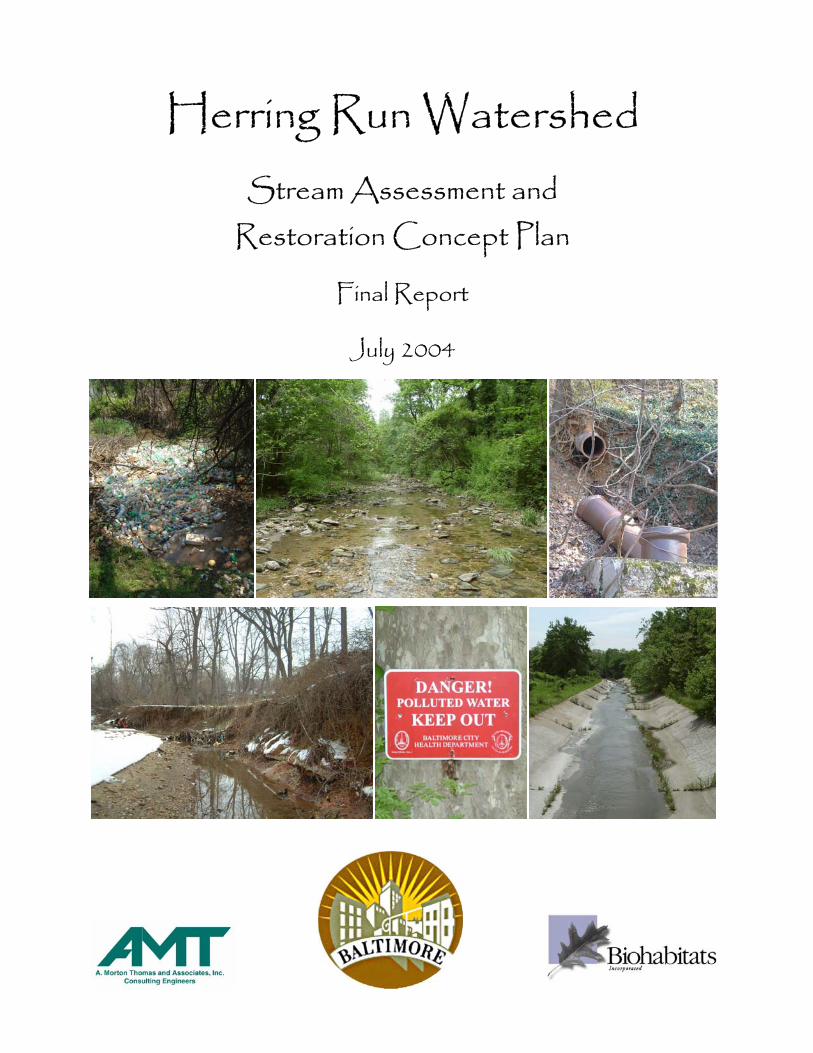
Herring Run Watershed
Stream Assessment and Restoration Concept Plan
Final Report
July 2004

Herring Run Watershed Stream Assessment and
Restoration Concept Plan
Final Report
July 2004
C
A. Morton Thomas & Associat12750 Twinbrook Parkway, Su
Rockville, MD 20852
Prepared for:
ity of Baltimore
Prepared by:
es, Inc. ite 200
Biohabitats, Inc. 15 West Aylesbury Road
Timonium, MD 21093

Herring Run Watershed Stream Assessment and Restoration Concept Plan
TABLE OF CONTENTS
1.0 INTRODUCTION................................................................................................. 1
1.1 BACKGROUND AND PROBLEM STATEMENT ........................................................................ 1 1.2 PROJECT GOALS AND SCOPE OF REPORT ............................................................................ 1 1.3 LOCATION OF STUDY AREA AND WATERSHED CHARACTERIZATION.................................. 2 1.4 ANTHROPOGENIC IMPACTS TO STREAMS ............................................................................ 4
2.0 METHODS ............................................................................................................ 6
2.1 CRUISED REACH ASSESSMENT ........................................................................................... 6 2.2 REACH RANKING ................................................................................................................ 9
2.2.1 Channel Stability Parameters.............................................................................................. 13 2.2.2 Habitat Parameters ............................................................................................................. 16
3.0 FIELD RESULTS AND RANKING ................................................................. 20
3.1 CRUISED REACH ASSESSMENT ......................................................................................... 20 3.2 REACH RANKING .............................................................................................................. 20 3.3 APPLICATION OF REACH RANKINGS ................................................................................. 21
4.0 STREAM RESTORATION TECHNIQUES ................................................... 25
4.1 OPPORTUNITIES AND CONSTRAINTS ................................................................................. 25 4.2 SPECIFIC RESTORATION STRATEGIES................................................................................ 27
4.2.1 Stabilize Banks Non-Structurally......................................................................................... 27 4.2.2 Stabilize Banks Structurally ................................................................................................ 28 4.2.3 Stabilize Channel Structurally............................................................................................. 29 4.2.4 Realign & Relocate Channel ............................................................................................... 30 4.2.5 Enhance Riparian Areas...................................................................................................... 31 4.2.6 Remove Channel Impediments............................................................................................. 33 4.2.7 Maintain Infrastructure ....................................................................................................... 34 4.2.8 Install Trash Rack ............................................................................................................... 34
4.3 LAND MANAGEMENT STRATEGIES ................................................................................... 35 4.3.1 Preservation of Existing Forested Areas............................................................................. 35 4.3.2 Reduction of Impervious Surfaces ....................................................................................... 36 4.3.3 Appropriate Road and Culvert Maintenance ...................................................................... 37 4.3.4 Public Education ................................................................................................................. 38
5.0 REACH RESTORATION CONCEPTS........................................................... 39
Biohabitats, Inc. © •INSPIRING ECOLOGICAL STEWARDSHIP•

Herring Run Watershed Stream Assessment and Restoration Concept Plan
5.1 RESTORATION CONCEPTS FOR REACH O, BIDDISON RUN................................................. 39 5.2 RESTORATION CONCEPTS FOR REACH P, BIDDISON RUN.................................................. 41 5.3 RESTORATION CONCEPTS FOR REACH T, MOORES RUN ................................................... 44 5.4 RESTORATION CONCEPTS FOR REACH U, MOORES RUN................................................... 46 5.5 COST ESTIMATES OF RESTORATION CONCEPTS ................................................................ 48
6.0 REFERENCES.................................................................................................... 50
Biohabitats, Inc. © •INSPIRING ECOLOGICAL STEWARDSHIP•

Herring Run Watershed Stream Assessment and Restoration Concept Plan
LIST OF TABLES TABLE 1.0 LENGTHS OF KEY STREAM REACHES ..................................................................................... 4
TABLE 2.0 PRIMARY FACTORS USED IN THE CHANNEL STABILITY RANKING ....................................... 11
TABLE 2.1 PRIMARY FACTORS USED IN THE HABITAT RANKING .......................................................... 12
TABLE 3.0 RESULTS OF CHANNEL STABILITY, HABITAT, AND TOTAL RANKING ................................... 21
LIST OF FIGURES FIGURE 1.0 LOCATION OF HERRING RUN WATERSHED WITH REACH BREAKS.......................................... 3
FIGURE 3.0 PRIORITY FOR CHANNEL STABILITY RESTORATION ............................................................. 22
FIGURE 3.1 PRIORITY FOR HABITAT RESTORATION ................................................................................ 23
FIGURE 3.2 PRIORITY FOR RESTORATION (CHANNEL STABILITY AND HABITAT).................................... 24
APPENDICES APPENDIX A CRUISED REACH DATA COLLECTION SHEETS
APPENDIX B CRUISED REACH DATA SUMMARY AND BEHI RESULTS
APPENDIX C REACH RANKING SYSTEM
APPENDIX D REACH O RESTORATION CONCEPT DESIGN
APPENDIX E REACH P RESTORATION CONCEPT DESIGN
APPENDIX F REACH T RESTORATION CONCEPT DESIGN
APPENDIX G REACH U RESTORATION CONCEPT DESIGN
APPENDIX H PHOTOGRAPHS OF PROBLEM AREAS ALONG REACHES O, P, T, AND U
APPENDIX I PRELIMINARY COST ESTIMATE FOR CONCEPT DESIGNS
Biohabitats, Inc. © •INSPIRING ECOLOGICAL STEWARDSHIP•

Herring Run Watershed Stream Assessment and Restoration Concept Plan
1.0 INTRODUCTION
1.1 BACKGROUND AND PROBLEM STATEMENT
In February of 2003, the City of Baltimore began an assessment of the mainstem channel
and tributaries of the Herring Run watershed within the City limits. This project, the
Herring Run Watershed Stream Assessment and Restoration Concept Plan, called for a
geomorphologic survey of approximately 18.4 miles of streams to identify and assess
existing conditions, prioritize reaches for restoration, and prescribe specific approaches
for several priority reaches.
The Herring Run watershed is under constant pressure from urban influences, which
threaten existing physical conditions and habitat values of the creek. Compared with
streams in less densely populated rural areas of Maryland, much of the stream is in poor
physical condition. Many portions of Herring Run are undergoing changes with adverse
consequences to the watershed at large. These problems are driven by encroaching urban
infrastructure, poor riparian buffers, and local bank erosion.
1.2 PROJECT GOALS AND SCOPE OF REPORT
It is the intent of this Stream Assessment and Restoration Concept Plan to provide some
general approaches to both 1) protecting existing stream and riparian areas and 2)
ameliorating those reaches that show the most degraded conditions. Stable, healthy
portions of the creek are critical for preservation given their natural tolerance to flood
effects, resilience against bank erosion, and high habitat value. Furthermore, maintaining
these conditions ultimately maintains good water quality conditions in the Herring Run
watershed and the Chesapeake Bay itself. Of equal importance is improving those areas
that pose the greatest water quality problems, thereby preventing additional deleterious
channel adjustments and management costs down the road.
Specifically, the Herring Run Stream Assessment and Restoration Concept Plan was
developed with the following objectives in mind:
Biohabitats, Inc. © •INSPIRING ECOLOGICAL STEWARDSHIP• 1

Herring Run Watershed Stream Assessment and Restoration Concept Plan
• To conduct a thorough “fluvial audit” of the stream network to identify and assess
existing geomorphic conditions and identify problem areas on a relative basis.
• To develop stream bank stabilization and riparian corridor recommendations that
would improve physical and habitat conditions in Herring Run and decrease
delivery of fine sediment to Herring Run and ultimately the Chesapeake Bay.
• To produce GIS coverages summarizing existing conditions to inform and/or
guide future restoration planning in a consistent format.
The Restoration Concept Plan followed several stages of development. First, existing
conditions were qualitatively and systematically documented by Biohabitats scientists,
who walked the approximately 18 miles of the Herring Run drainage network within the
City limits. Next, the information was synthesized to rank problematic reaches. Finally,
for several of the most impacted reaches, restoration concepts were developed to improve
unstable portions of the channel.
This report is conceptual in nature and is not intended to be exhaustive in its methods,
content, or recommendations. Ultimately, however, the information presented within this
report is intended to assist agencies and landowners’ consultants in the planning and
conceptual design of water quality improvement projects, including stream stabilization
and riparian revegetation projects. For example, if a landowner pursues the stabilization
of a bank as recommended in the concept plan, implementation of the structure may
require additional field investigations, detailed design drawings, and permits from
multiple agencies.
1.3 LOCATION OF STUDY AREA AND WATERSHED CHARACTERIZATION
Herring Run is a highly urbanized stream that discharges into the Back River before
reaching the Chesapeake Bay east of Baltimore City. This study concerns the portion of
Herring Run and its major tributaries that lie within the City limits (Figure 1.0). Herring
Run drains an approximately 31 mi2 area (to the Back River confluence) of the
Chesapeake Bay watershed. Headwaters originate outside the northeastern limits of the
City of Baltimore. There are five major branches in the drainage network of Herring
Biohabitats, Inc. © •INSPIRING ECOLOGICAL STEWARDSHIP• 2

Herring Run Watershed Stream Assessment and Restoration Concept Plan
INSERT FIGURE 1.0
Biohabitats, Inc. © •INSPIRING ECOLOGICAL STEWARDSHIP• 3

Herring Run Watershed Stream Assessment and Restoration Concept Plan
Run: Chinquapin Run, West Branch, Moores Run, Biddison Run, and Armistead
Tributary. Each branch comprises over 1 mile of the total network length (Table 1.0).
Table 1.0 Lengths of Key Stream Reaches
Length Stream Reach
Linear Feet Miles
Herring Run: Mainstem and Unnamed Tributaries 44,329 8.40
West Branch 9,772 1.85
Chinquapin Run 13,956 2.64
Moores Run 13,095 2.48
Biddison Run 9,123 1.73
Armistead Tributary 6,977 1.32
Total 97,252 18.42
The Herring Run watershed lies at the interface of the Middle Atlantic Piedmont and
Coastal Plain physiographic provinces. The landscape within the Herring Run watershed
within the City limits in relatively flat with low, broad rolling hills. There exists a
patchwork of land use, riparian conditions, and associated stream conditions through the
Herring Run watershed within Baltimore City limits. The remaining riparian areas
include a diversity of forest types from early- and mid-successional deciduous forests
dominated by Eastern hardwoods. Deer browse is generally minimal due to proximity to
roadways, residences, and commercial activity. Invasive species are numerous and
extensive in the riparian areas surrounding the creeks.
1.4 ANTHROPOGENIC IMPACTS TO STREAMS
Changes in land use within a watershed, such as through residential development, can
and most often do result in negative impacts to water quality, stability of stream channels,
and habitat within a watershed and to receiving bodies of water. As land is deforested for
development, the magnitude and frequency of stormwater runoff (nonpoint source runoff)
increase and higher pollutant loads are delivered downstream. Pollutant loads can
include sediment, nutrients, and heavy metals.
Biohabitats, Inc. © •INSPIRING ECOLOGICAL STEWARDSHIP• 4

Herring Run Watershed Stream Assessment and Restoration Concept Plan
The changes in the runoff regime that are associated primarily with nonpoint source
runoff also result in stream channel adjustments to accommodate the increases in flow,
including channel bank erosion and channel bed incision. Aquatic habitat is impaired as
a result of the decline in water quality and stream channel condition. Riparian conditions
are often impaired as well, including the reduction or elimination of forest buffer along
stream channels and increases in invasive species among the plant communities in these
disturbed areas. These impacts to the riparian condition result in aquatic and terrestrial
habitat loss, reduction in the filtering capacity of pollutants along these streamside zones,
and increased stream channel erosion as a result of the loss of root mass from woody
material.
While there are no datasets available which track physical adjustments of Herring Run
with incremental development in the watershed, it is likely that some such changes have
occurred. It is also common that stream adjustment lags behind physical changes in the
supply of sediment and water to the channel. Therefore, it is possible that the creek has
not fully achieved a new geometry that can convey this altered flow regime and the
sediment supplied to the channel giving the existing conditions in the watershed. If this
is the case, additional channel changes can be expected in the future as the creek
continues to adjust, and additionally if future land use changes in the watershed induce
more change. For these reasons, it is important to continue to observe the physical
condition of Herring Run in the future and address any critical problems promptly as they
are identified.
Biohabitats, Inc. © •INSPIRING ECOLOGICAL STEWARDSHIP• 5

Herring Run Watershed Stream Assessment and Restoration Concept Plan
2.0 METHODS
Preparation of this Stream Assessment and Restoration Concept Plan required two main avenues
for methodology: cruised reach assessment and ranking of reach data. Ultimately the two
methods provided a database for description of the existing conditions of the reaches and ranking
them.
2.1 CRUISED REACH ASSESSMENT
The cruised reach assessment was conducted to 1) familiarize the team with the
conditions of the watershed, and 2) identify problem areas within evaluated reaches.
Cruised reach assessment began with the development of field data collection sheets.
The creation of field data collection sheets was intended to provide a consistent means of
evaluating individual reaches along the Herring Run watershed. The consistency stems
from the use of field data sheet collection sheets that include a standard set of parameters
to be evaluated for each reach. Summarization of the collected information allows both a
broad-brush characterization of the existing conditions of the channel and riparian area of
each reach, and also a more detailed comparison between reaches for ranking of their
potential for restorative measures (see Section 2.2).
Prior to conducting the field campaign, Biohabitats’ staff visited portions of the Herring
Run watershed to observe a “sampling” of conditions to help direct the development of
the field data collection sheets. Based on observation during this field work, Biohabitats
determined the type of parameters that would be necessary for data collection.
It was determined that no standardized, preexisting field data collection forms fit
particularly well with anticipated needs. The creation of field assessment sheets for data
collection, therefore, drew from several available stream data collection formats,
including the USDA NRCS’s Stream Visual Assessment Protocol (1998) and Maryland’s
Stream Corridor Assessment Survey (2001), but also included additional elements. An
example of the final developed data collection sheet is shown in Appendix A. Sheet 1
was used to record channel type, substrate, gradient, and channel morphology
information. Sheet 2 included descriptions of culverts, outfalls and exposed pipes, as
Biohabitats, Inc. © •INSPIRING ECOLOGICAL STEWARDSHIP• 6

Herring Run Watershed Stream Assessment and Restoration Concept Plan
well as Bank Erosion Hazard Index (BEHI) information. Parameters evaluated on Sheet
3 could be assigned an arbitrary level between 1 to 10 with an associated description
(these values underwent weighting in the later ranking process and do not themselves
represent point values). This allowed an evaluator to record subtle differences between
reaches (in up to 10 levels) and reduced the potential for low and high scores to be
damped out later during the ranking process.
Stream scientists then conducted a “cruised” survey of the mainstem and the major
tributaries of the Herring Run watershed within the City limits. “Cruising” consisted of a
team of two environmental scientists walking the length of the stream and recording
channel morphology, disturbance, stability, and habitat parameters on the data collection
sheets.
There was no predetermined limit to reach lengths. Instead, reach boundary breaks were
predicated only upon a distinct change in Rosgen channel type classification (Rosgen,
1996). Additional factors that determined reach breaks included one or more of the
following: 1) dramatic and consistent changes in stream morphology, bank condition,
and/or riparian condition, and 2) locations of roadway crossings, tributary confluences,
culverts, and/or outfalls. Because Herring Run includes mostly B and C type channel and
similar stability problems occur in most reaches, reach lengths were quite protracted. Of
the 24 reaches that were identified, reach lengths range from approximately 1,275 to
7,560 feet, with an average length of 4,050 feet.
For each reach, one set of observations was recorded. Listed below are the specific
parameters that were evaluated during the field survey (also see Appendix A). Asterisks
indicate those parameters later used to develop the ranking system and are described in
more detail in Section 2.2. At least one surveyed cross section was also conducted along
each reach to refine stream type determination and quantify representative channel
dimensions.
Biohabitats, Inc. © •INSPIRING ECOLOGICAL STEWARDSHIP• 7

Herring Run Watershed Stream Assessment and Restoration Concept Plan
General
Main Rosgen stream type
Secondary stream types
Bed material sizes present
Estimated median grain size
Bedrock control of bed*
Bedrock control of banks*
Channel slope (estimated)
Sinuosity (estimated)
Bankfull indicators
Bankfull channel dimensions
Surrounding land uses
Channel Disturbance
• Culvert
• Outfalls
• Direct human channel impacts
• Bridges
• Exposed pipes
Channel Stability Parameters
Overall channel conditions*
Degree of channel incision*
Bed stability*
Bank stability*
Bank Erosion Hazard Index (BEHI) measurements*
Habitat Parameters
Riparian invasive plant species*
Canopy cover*
Nutrient enrichment
Biohabitats, Inc. © •INSPIRING ECOLOGICAL STEWARDSHIP• 8

Herring Run Watershed Stream Assessment and Restoration Concept Plan
Width of riparian zone*
Terrestrial habitat/riparian composition*
Riffle embeddedness*
Barriers to fish movement*
Instream fish cover*
Pools*
Insect/Invertebrate habitat*
Degree of human intervention*
Other parameters, such as drainage area to individual reaches, were measured from maps
in the office. Digital photographs were also taken at each culvert, outfall, and exposed
pipe to help record existing reach conditions.
Observations recorded on data sheets were summarized in a series of tables (Appendix
B). The database can be queried by GIS for any parameter(s) of interest, and can be
expanded as additional observations and data are collected in the watershed.
2.2 REACH RANKING
Ranking of the field observations assisted in: 1) prioritizing the need of specific
restoration approaches (e.g., bank stabilization and riparian revegetation), 2) identifying
common findings between ranking parameters as a means of verification of priority areas
3) highlighting strengths and shortcomings for identifying the most appropriate
parameters, and 4) developing the Restoration Concept Plan to establish and prioritize
suitable management approaches by reach.
After completion of the field work, stream scientists identified those variables that they
observed to be most indicative of channel problems and that would assist in stratifying
the reaches into priority categories for restoration techniques. A ranking system was
developed to identify those reaches appropriate for channel restoration and riparian
revegetation. Primary factors used to rank channel problems were grouped into two
broad categories: 1) channel stability, and 2) habitat conditions. (There are strong
Biohabitats, Inc. © •INSPIRING ECOLOGICAL STEWARDSHIP• 9

Herring Run Watershed Stream Assessment and Restoration Concept Plan
connections and overlap between the factors; however, this organization allows for some
useful generalizations.) Additional information was used to provide detail and support
for these rankings in later recommendations.
Next, a point-based ranking system was imposed for each parameter. This involved the
assignment of a point value to each reach parameter based on field observations. The
maximum number of points possible for a selected parameter is based on the relative
importance of that parameter to the overall reach ranking. Specifically, the breakdown of
possible points awarded for each parameter was based on 1) professional judgment of the
significance of different levels (e.g., what should be the difference in ranking points
between a >12mi2 and 8-12 mi2 drainage area?) and 2) the need to better differentiate
between reaches by imposing weighting factors to increase the point spread within an
individual parameter (e.g., how many more ranking points should a good rating of “9”
versus “8” be worth for the parameter “canopy cover?”).
After the initial rankings were completed, scientists revisited a subset of reaches with
high, average, and low rankings to verify that the ranking system successfully compared
and contrasted the existing conditions of the study reaches in a comprehensive manner.
Minor revisions were then made to the ranking system. Table 2.1 and 2.2 broadly
indicate how points were assigned to each reach based on the recorded level of each
parameter and the percentage of channel length that fell into each category. A more
comprehensive table showing the weighting factors and the range of points assigned to
each parameter of each reach is included in Appendix C.
It should be noted that the rating point cutoffs are subjective and suit the purposes of this
study in that they exaggerate the differences between reaches and cumulatively assess
physical function. This approach helped develop a relative prioritization of problems on
a reach basis. These were checked with professional judgment to assess appropriateness
of these rankings, and were found to capture the range of noted conditions.
Biohabitats, Inc. © •INSPIRING ECOLOGICAL STEWARDSHIP• 10

Herring Run Watershed Stream Assessment and Restoration Concept Plan
Table 2.0 Primary Factors Used in the Channel Stability Ranking and Results on Reach Basis.
Reaches at Given Level of Parameter
Parameter Level of Parameter
Rating Points Assigned to
Level* Stream Length (mi)
Percent Length (%)
*Maximum 100 rating points possible. Higher scores indicate better conditions and/or lesser need for restoration based on parameter.
>12 mi2 10 5.8 31.4 8-12 mi2 8 2.8 15.4 4-8 mi2 4 2.3 12.4 2-4 mi2 2 3.2 17.5
Drainage Area to Reach
0-2 mi2 0 4.3 23.3 Total 18.4 100.0
Excellent 20 0.0 0.0 Good 8-14.4 6.8 36.9 Fair 2.6-5.2 7.7 42.0
Overall Channel
Condition Poor 0 3.9 21.1 Total 18.4 100.0
Likely Stable 10 14.6 79.0 Possibly Stable 9 3.0 16.3 Indeterminate 8 0.0 0.0 Aggrading 0 0.0 0.0
Bed Stability
Degrading 0 0.9 4.6 Total 18.4 100.0
Yes: Pervasive 10 1.8 9.9 Yes: Moderate 8 3.8 20.6 Yes: Local 4 3.5 18.9
Bedrock Control of
Bed No 0 9.3 50.6 Total 18.4 100.0
Excellent 20 2.3 12.5 Good 8-14.4 8.4 45.6 Fair 2.6-5.2 7.7 42.0
Bank Stability
Poor 0 0.0 0.0 Total 18.4 100.0
<10% High and 0 9.4 51.0 25% >High ≥ 50% -5 4.8 25.9 BEHI ≥ 25 % High -10 4.3 23.1
Total 18.4 100.0 Yes: Pervasive 10 2.2 11.9 Yes: Moderate 6 1.6 8.5 Yes: Local 2 3.6 19.7
Bedrock Control of
Banks No 0 11.0 59.9 18.4 100.0
Degree of Excellent 20 0.0 0.0
Biohabitats, Inc. © •INSPIRING ECOLOGICAL STEWARDSHIP• 11

Herring Run Watershed Stream Assessment and Restoration Concept Plan
Reaches at Given Level of Parameter
Parameter Level of Parameter
Rating Points Assigned to
Level* Stream Length (mi)
Percent Length (%)
Good 11.2-14.4 3.2 17.3 Fair 5.2-7.8 7.5 40.8 Poor 2-3 5.2 28.1
Very Poor 0 2.5 13.7 Total 18.4 100.0
Table 2.1 Primary Factors Used in the Habitat Ranking.
Reaches at Given Level of Parameter Parameter Level of
Parameter
Rating Points
Assigned to
Level* Stream Length
(mi) Percent Length
(%) *Maximum 100 rating points possible. Higher scores indicate better conditions and/or lesser need
for restoration based on parameter. Excellent 14 4.8 26.3Good 10 8.0 43.4Fair 5 3.9 21.1Poor 1 1.3 7.1
Riparian Zone: Left
Very Poor 0 0.4 2.1 Total 18.4 100.0
Excellent 14 3.4 18.7Good 10 9.1 49.4Fair 5 3.9 21.1Poor 1 1.6 8.6
Riparian Zone: Right
Very Poor 0 0.4 2.1 Total 18.4 100.0
Excellent 8 9.6 52.0Good 6 5.4 29.1Fair 4 0.8 4.5Poor 1 2.3 12.3
Terrestrial Habitat
Very Poor 0 0.4 2.1 Total 18.4 100.0
Excellent 8 0.0 0.0Good 6 4.1 22.1Fair 4 6.4 34.7Poor 1 7.4 40.2
Riparian Invasives
Very Poor 0 0.6 3.0 Total 18.4 100.0
Excellent 8 0.0 0.0Good 6 9.1 49.2
Canopy Cover
Fair 4 6.0 32.5
Biohabitats, Inc. © •INSPIRING ECOLOGICAL STEWARDSHIP• 12

Herring Run Watershed Stream Assessment and Restoration Concept Plan
Reaches at Given Level of Parameter Parameter Level of
Parameter
Rating Points
Assigned to
Level* Stream Length
(mi) Percent Length
(%) Poor 1 2.1 11.6 Very Poor 0 1.2 6.7
Total 18.4 100.0Excellent 8 3.3 18.1Good 6 7.8 42.5Fair 4 3.6 19.6Poor 1 3.1 16.6
Riffle Embeddedness
Very Poor 0 0.6 3.1Total 18.4 100.0
Excellent 8 2.1 11.4Good 6 4.0 22.0Fair 4 1.2 6.7Poor 1 3.1 17.0
Barriers to Fish Movement
Very Poor 0 7.9 43.0 18.4 100.0
Excellent 8 0.0 0.0Good 6 4.2 24.0Fair 4 11.4 62.0Poor 1 2.0 10.9
Instream Fish Cover
Very Poor 0 0.6 3.0 Total 18.4 100.0
Excellent 8 2.7 23.8Good 4 0.6 5.7Fair 1 3.0 26.9Pools
Poor 0 1.4 12.2 Total 18.4 100.0
Excellent 8 5.0 26.9Good 6 10.4 56.7Fair 4 2.5 13.4
Insect/Invertebrate Habitat
Poor 1 0.6 3.0 18.4 100.0
Excellent 8 0.0 0.0Good 4 5.9 32.2Fair 1 7.7 41.9
Human Intervention
Poor 0 4.8 25.9 Total 18.4 100.0
2.2.1 Channel Stability Parameters
For the ranking of channel stability, eight parameters were selected: 1) drainage area to
the reach, 2) overall channel condition, 3) bed stability, 4) bedrock control of bed, 5)
Biohabitats, Inc. © •INSPIRING ECOLOGICAL STEWARDSHIP• 13

Herring Run Watershed Stream Assessment and Restoration Concept Plan
bank stability, 6) Bank Erosion Hazard Index (BEHI), 7) bedrock control of banks, and 8)
degree of channel incision. Below is a brief description of these parameters and there
relative importance in the channel stability ranking.
Drainage Area to Reach
The drainage area to each reach is incorporated in the ranking system to distinguish
between relatively smaller and larger streams. The intent of including drainage area is to
place additional emphasis on taking action in smaller streams, since they are source areas
in terms of sediment and water (hydrology) and therefore have consequences to
downstream reaches. In additional, stream rehabilitation in smaller streams is more cost
effective, since more techniques are generally available for use and require less spatially
extensive coverage. Up to 10 points (out of 100 total possible) are assigned to each
reach’s ranking based on drainage area.
Overall Channel Condition
The parameter “overall channel condition” is worth up to 20 points in the ranking. This
parameter was intended to be a catch-all index of the channel condition resulting from the
interaction of individual factors such as bank stability, natural character, bed stability,
and the degree of channel recovery from past activities.
Bed Stability
Bed stability is included in the ranking since it can generate significant sediment yields
and can have deleterious consequences to banks and water quality. Field indicators of
degradation (progressive downcutting of the channel into its deposits) include the
presence of a knickpoint, lack of depositional features, undercutting at the toe of slope,
and irregular claypan bed topography. Field indicators of aggradation (chronic
deposition of sediment on the bed) include depositional features such as midchannel bars,
a relative abundance of fine sediment along the bed, and, in many cases, associated bank
erosion. Bed stability is worth up to 10 points in the ranking.
Biohabitats, Inc. © •INSPIRING ECOLOGICAL STEWARDSHIP• 14

Herring Run Watershed Stream Assessment and Restoration Concept Plan
Bedrock Control of Bed
Bedrock plays an important role in stream processes of Herring Run and the resulting
planform and cross-sectional pattern. Bedrock outcrops occur intermittently along the
bed and banks of the creek and subsequently protect these locations from erosion. For
this reason, the degree of bedrock control is included as a ranking parameter worth up to
10 points. The degree of bedrock control was assessed in the field based simply on the
relative abundance of bedrock outcropping along the bed and banks of a reach.
Bank Stability
Bank stability was assessed as an index of the overall severity of bank erosion and
sediment supplied to the channel. Assessment of bank erosion was based on factors such
as streambank angle and shape, undercutting of root masses, exposed roots, lack of
surficial protection (e.g., by vegetation), evidence of recent soil removal and slumping,
and active erosion processes such as dry ravel. Field observations suggested that bank
stability is especially important in distinguishing restoration potential on a reach basis,
and is therefore worth up to 20 points in the channel stability ranking.
Bank Erosion Hazard Index
Developed by Rosgen (1996), Bank Erosion Hazard Index (BEHI) scores provide an
indicator of the extent of any local, extreme bank erosion processes. Representative
BEHI measurements were used to identify the percentage of banks in each reach with low
up to extreme erosion hazards. BEHI scores are based on such factors as streambank
angle, root density, bank height versus bankfull depth, and the amount of surficial
protection. In contrast to other parameters, BEHI is scored as a subtractive factor, such
that up to 10 points are deducted due to poor BEHI ratings.
Bedrock Control of Banks
Bedrock plays an important role in stream processes of Herring Run and the resulting
planform and cross-sectional pattern. Bedrock outcrops occur intermittently along the
bed and banks of the creek and subsequently protect these locations from erosion. For
this reason, the degree of bedrock control is included as a ranking parameter worth up to
Biohabitats, Inc. © •INSPIRING ECOLOGICAL STEWARDSHIP• 15

Herring Run Watershed Stream Assessment and Restoration Concept Plan
10 points. The degree of bedrock control was assessed in the field based simply on the
relative abundance of bedrock outcropping along the bed and banks of a reach.
Degree of Channel Incision
Assessment of channel incision provides an index of how impacted a reach is from past
management activities. The level of channel incision was evaluated by comparing the
elevation of bankfull relative to the elevation of the adjacent floodplain. For those
reaches with significant incision, floodplain vegetation is separated from the water table
and does not interact with lower flows. Instead shear stresses are exerted directly along
the bed and lower banks with little protection from plant roots. In many cases of
significant channel incision, channels are unable to “self-recover.” For this reason, as
many as 20 points are awarded for this parameter within the ranking system.
2.2.2 Habitat Parameters
Eleven parameters were identified as essential to defining the quality and quantity of in-
stream and riparian habitat: 1) width of left riparian zone, 2) width of right riparian zone,
3) terrestrial habitat, 4) riparian invasives, 5) canopy cover, 6) riffle embeddedness, 7)
barriers to fish migration, 8) in-stream fish cover, 9) pools, 10) insect/invertebrate habitat,
and 11) human intervention.
Even though it has dire consequences to in-stream habitat and water quality, nutrient
enrichment was not included in the habitat ranking. Field observations suggested that
nutrient enrichment was most strongly linked to recent sewage leaks, and was therefore
too transient spatially (depending on local breaks and follow-up maintenance) to be
indicative of longer term reach conditions. Although nutrient enrichment is not included
in the reach rankings, it remains a critical factor in stream health.
Riparian Zone Width: Left and Right
Riparian width is an indicator of both the bank stability afforded by vegetation and
available sediment trapping function. Riparian areas also provide important habitat and
nutrient processing. The forested riparian buffer width was estimated in the field based
Biohabitats, Inc. © •INSPIRING ECOLOGICAL STEWARDSHIP• 16

Herring Run Watershed Stream Assessment and Restoration Concept Plan
on average reach conditions for each bank. Because the natural landscape is forested,
riparian areas consisting of only lawns and other such grasses were considered to have no
effective width. Given the high variability in riparian zone widths between reaches and
the strong potential for revegetation in sparse areas, this parameter is weighted strongly,
with up to 28 points possible (out of 100 total possible) between both banks.
Terrestrial Habitat
The number of layers present in the riparian zone (e.g., trees, shrubs, and herbaceous
species) affects the health, integrity and habitat complexity of terrestrial areas. Up to 8
points are awarded to the habitat ranking based on terrestrial habitat. This factor is
scored independently of the density of riparian invasives, which is considered as a
separate parameter.
Riparian Invasives
Invasive species are both widespread and dense throughout the majority of the Herring
Run watershed. Because they displace native plants, reduce food and shelter for native
wildlife, eliminate host plants of native insects, and compete for native pollinators,
riparian invasives can greatly impact riparian health. Along many reaches of Herring
Run, riparian invasives are spreading rapidly and threatening to produce a riparian
monoculture (single plant species), which has little ecological value. Up to 8 points are
awarded for the level of riparian invasives in the ranking system.
Canopy Cover
Canopy cover provides a good integrator of riparian width, canopy height, canopy
density, and stream shading. In many cases reduced canopy cover corresponds to those
areas with extensive human intervention, particularly residential and industrial
development. Up to 8 points are assigned to the canopy cover component of the habitat
ranking.
Biohabitats, Inc. © •INSPIRING ECOLOGICAL STEWARDSHIP• 17
Herring Run Watershed Stream Assessment and Restoration Concept Plan
Riffle Embeddedness
Riffle embeddedness, the degree to which riffle areas were buried by fine sediment, is a
good indicator of sediment supply delivered to a reach. High riffle embeddedness can be
problematic to fish, benthic organisms, and other aquatic species. Reaches are assigned
up to 8 points based on riffle embeddedness.
Barriers to Fish Movement
Since they limit the movement and/or migration of fish through the stream network,
barriers to fish movement were included in the ranking. Depending on the number and
severity of barriers along an individual reach, up to 8 points are awarded for this
parameter.
Instream Fish Cover
Complex in-stream habitat provides important refugia to fish. The following items were
noted as providing instream fish cover and are collectively worth up to 8 points in the
ranking: logs/large woody debris, deep pools, overhanging vegetation, boulders/cobbles,
riffles, undercut banks, thick root mats, dense macrophyte beds, and isolated/backwater
pools.
Pools
Pools also provide important refugia for aquatic species. The abundance and depth of
pools was evaluated as an additional important aspect of in-stream habitat, and comprise
up to 8 points in the habitat ranking of each reach.
Insect/Invertebrate Habitat
Insect and invertebrate habitat was qualitatively assessed for each reach based on the
presence of fine woody debris, submerged logs, leaf packs, undercut banks, cobbles,
boulders, and coarse gravel. Reaches with these features receive up to 8 points in the
habitat ranking.
Biohabitats, Inc. © •INSPIRING ECOLOGICAL STEWARDSHIP• 18

Herring Run Watershed Stream Assessment and Restoration Concept Plan
Human Intervention
The degree of human intervention was assessed to determine the extent of natural channel
function remaining along each reach. Up to 8 points are assigned for this parameter.
Those reaches with extensive bank and bed protection, culverts and/or utilities lines, and
persistent evidence of straightening were recorded as having high human intervention.
Those areas in which significant channel recovery had occurred or the channel
boundaries were primarily natural received higher (better) human intervention scores.
Biohabitats, Inc. © •INSPIRING ECOLOGICAL STEWARDSHIP• 19

Herring Run Watershed Stream Assessment and Restoration Concept Plan
3.0 FIELD RESULTS AND RANKING
3.1 CRUISED REACH ASSESSMENT
Results of the cruised reach assessment are summarized in Appendix B. Not
surprisingly, results from the reaches are highly variable and difficult to generalize across
the watershed. Most reaches, however, are coarse-bedded C type streams with relatively
low sinuosity. Approximately half of the reaches are influenced by localized bedrock
outcrops. Residential and forest are the most common adjacent land uses. When
comparing results among all twenty-four reaches, no reach has overwhelming “good” or
“poor” conditions. Instead, each reach shows a complicated combination of factors.
Results shown in Appendix B should be referred to for the most complete picture of each
reach.
3.2 REACH RANKING
Figures 3.0 and 3.1 illustrate the priority of restoration based upon channel stability
versus habitat, respectively, as a result of the ranking system. Figure 3.2 shows the
overall need for restoration, and considers both existing channel stability and habitat
attributes on a reach basis. Ranking scores associated with these priority designations are
summarized below in Table 3.0.
Generally speaking, tributaries have a significantly higher priority for restoration rather
than mainstem reaches of Herring Run. Main reasons for this difference probably stem
from several factors: 1) low order (smaller) streams are generally source areas for
sediment and more readily display erosional problems, whereas higher order (larger)
streams are transport areas that respond to upstream input of high sediment loads, and 2)
there are more parklands adjacent to the mainstem Herring Run than tributary areas,
which allow more beneficial channel-floodplain interactions and more extensive riparian
areas.
For each of the eight channel stability and the eleven parameter used in the ranking
system, the detailed ranking results are summarized in Appendix C. Specific activities
Biohabitats, Inc. © •INSPIRING ECOLOGICAL STEWARDSHIP• 20

Herring Run Watershed Stream Assessment and Restoration Concept Plan
for revegetation and stream restoration are discussed more in Section 4.0.
Table 3.0 Results of Channel Stability, Habitat, and Total Rankings
Channel Stability Habitat Channel Stability +
Habitat
Ranking
Score Reach
Ranking
Score Reach
Ranking
Score Reach
-0.5 O 18.0 R 39.6 E 1.6 L 20.0 B2 41.5 O 6.6 E 25.0 K 52.0 B2 10.8 P 33.0 E 55.6 L 16.1 W 35.0 J2 61.0 R 25.2 U 35.0 S 66.1 W 29.8 A 42.0 O 67.8 P 32.0 B2 45.0 B 71.5 K 33.8 B 49.0 T 77.9 S 34.4 T 50.0 W 78.8 B 35.7 D 53.0 D 83.4 T 40.0 V 53.0 V 86.2 U 40.9 G 54.0 C 86.8 A 42.6 Q 54.0 G 87.6 J2 42.9 S 54.0 L 88.7 D 43.0 R 54.0 M 93.0 V 45.0 M 55.0 Q 94.9 G 46.5 K 56.0 I 97.6 Q 52.6 I 57.0 A 99.0 M 52.6 J2 57.0 P 108.6 I 54.3 C 58.0 H 108.3 C 59.2 F 61.0 U 125.2 F 69.3 J 66.0 F 135.3 J
Poorer
Conditions
Better
Conditions 78.4 H 66.0 J 136.4 H Average 37.2 47.9 85.1
3.3 APPLICATION OF REACH RANKINGS
The reach ranking results are intended to provide a stand-alone assessment of the need for
stream restoration on a reach basis, given observed physical and habitat conditions in the
watershed. It is anticipated that the selection of reaches for future restoration activities
will rely on the results presented in this Stream Assessment and Restoration Concept
Biohabitats, Inc. © •INSPIRING ECOLOGICAL STEWARDSHIP• 21

Herring Run Watershed Stream Assessment and Restoration Concept Plan
Plan. However, additional factors would also be considered for the final selection of
reaches for restoration activities. These factors could include 1) internal priorities within
the City, 2) available funding, and 3) connectivity between reaches for the purposes of
further prioritization. These factors are described further below.
Internal priorities of the City for stream restoration activities may also be affected by
specific threats to infrastructure (e.g., bridge abutment scour, exposed pipes, etc.),
community feedback (e.g., concentrations of complaints by homeowners), and other
ongoing City projects that could be combined with stream restoration work (e.g.,
stormwater detention projects, park improvements, urban BMPs). Addressing these types
of concerns in conjunction with undertaking stream restoration will be a cost-effective
approach that will factor into decision-making. Available funding will pose limits on the
overall size and scope of any such project.
For several reasons, reach connectivity will be an additional important factor in selection
of reaches for restoration activities. First, for example, if a reach is assigned a “very
high” priority for channel stability restoration and it is located immediately upstream of a
reach with good channel stability and/or aquatic habitat, it may be especially important to
restore the upstream reach to protect the downstream reach. Specific examples of this
include: (1) Reach D (high priority ranking for restoration in Figure 3.2), which feeds
into Reach F (low priority) and Reach G (moderate priority), and (2) Reaches A (high
priority), B (high priority), B2 (very high priority), and E (very high priority), which feed
into Reaches C (moderate priority) and Reach H (low priority).
In addition, by lumping several reaches together with varying priority rankings, a longer,
more comprehensive restoration design could be developed between reaches with varying
priority rankings. Finally, given that construction costs generally decrease on a linear
foot basis due to an “economy of scale” effect, maximizing project length may be an
important strategy for the City. For example, the restoration of reaches B2 and/or E
could also consider including Reaches B, A, and E to be more comprehensive, effective,
and cost-effective.
Biohabitats, Inc. © •INSPIRING ECOLOGICAL STEWARDSHIP• 21

Herring Run Watershed Stream Assessment and Restoration Concept Plan
INSERT FIGURE 3.0
Biohabitats, Inc. © •INSPIRING ECOLOGICAL STEWARDSHIP• 22

Herring Run Watershed Stream Assessment and Restoration Concept Plan
INSERT FIGURE 3.1
Biohabitats, Inc. © •INSPIRING ECOLOGICAL STEWARDSHIP• 23

Herring Run Watershed Stream Assessment and Restoration Concept Plan
INSERT FIGURE 3.2
Biohabitats, Inc. © •INSPIRING ECOLOGICAL STEWARDSHIP• 24
Herring Run Watershed Stream Assessment and Restoration Concept Plan
4.0 STREAM RESTORATION TECHNIQUES
Herring Run is a disturbed system with complex hydrologic, sedimentological, and
vegetative conditions. With such a broad array of existing conditions, numerous
restoration measures should be applied in concert to successfully restore the system to a
stable condition. Restoration measures should exploit both opportunities and work
around constraints to allow implementation and effectiveness.
Based on results from this ranking, internal priorities within the City, and contiguity of
reaches, the City of Baltimore selected Biddison Run (Reaches O and P) and Moores Run
(Reaches T and U) for the development of restoration reaches. Restoration concepts for
these four reaches are described in Section 4.0. Additional reaches may be added in the
future as more funding becomes available.
The primary purpose for restoring Biddison and Moores Run is to correct and prevent
severe degradation of the channel and to promote/improve the health of the surrounding
ecosystem. Recommended structural strategies include measures like stabilizing channel
invert elevations with grade control and channel banks with revetments. Non-structural
techniques include regrading and vegetating banks, or the use of soil bioengineering
techniques. Additionally, invasive species management and repairs to infrastructure
would improve watershed and stream conditions. Benefits of these types of restoration
approaches may include:
• Acceleration of the stream's natural recovery processes,
• Correct or prevention of severe problems or threats to infrastructure, ecosystem
health, or property, and
• Improvements to the channel when it is not possible to correct inputs to the
system outside of the channel.
4.1 OPPORTUNITIES AND CONSTRAINTS
General opportunities and constraints posed by this project are outlined below. Site
constraints have been taken into account in each concept design. As the project
Biohabitats, Inc. © •INSPIRING ECOLOGICAL STEWARDSHIP• 25

Herring Run Watershed Stream Assessment and Restoration Concept Plan
progresses, more specific items may be identified and designs can be adjusted
accordingly.
Opportunities
• Removal of non-native, invasive species in the adjacent floodplain before the
percent cover of invasive species inhibits native species
• Improvement of channel-floodplain interaction by reshaping channel geometry
• Improvement of aquatic and terrestrial habitats
• Spot stabilization of bank erosion using natural materials for bank protection, soil
bioengineering, or other means
• Improvement of water quality via reduction in bed and bank erosion
• Improved channel and floodplain aesthetics
Constraints
• Existing utilities (sewer and water pipes, electric lines)
• Existing roads and culverts
• Existing trees that should be retained
• Easement and access (property ownership, stakeholder participation)
• Regulatory requirements (including City, County, State, and Federal)
• Existing and future hydrologic conditions
• Economic considerations, including design and construction costs versus
available resources
• Public concerns
Access
Implementation of conceptual designs may require access to the stream by large
equipment for removal of soil and replacement with restoration materials. Access to
the site could be obtained by numerous ways from nearby residential roads. There
are several alternative access points to the stream channel that should result in the
least amount of disturbance.
Biohabitats, Inc. © •INSPIRING ECOLOGICAL STEWARDSHIP• 26

Herring Run Watershed Stream Assessment and Restoration Concept Plan
4.2 SPECIFIC RESTORATION STRATEGIES
The following strategies are recommended for use in the restoration of Biddison and
Moores Run based on existing conditions, opportunities, and constraints. Individual
strategies and the location of their application were determined based on existing stream
conditions identified during additional site visits. For example, bank stabilization
measures recommended for Biddison and Moores Run vary based on the extent, type, and
severity of the erosion, and include non-structural and structural approaches.
Strategies described below are not necessarily mutually exclusive and are used in a
complementary fashion throughout the design concepts to produce a comprehensive
restoration plan. Specific information about where these measures are recommended is
included in Section 5.0 and in Appendices D (Reach O), E (Reach P), F (Reach T), and G
(Reach U).
4.2.1 Stabilize Banks Non-Structurally
Bank regrading should be performed to adjust the bank angle and increase the stream’s
access to its floodplain. This both reduces the erosive power of the stream and provides
water to floodplain wetland areas. This method works best where there are minimal
lateral constraints. Three types of bank grading are proposed for Moores Run and
Biddison Run: regrading of the entire bank, regrading the top of the bank, and grading a
bench in the banks. Soil bioengineering can also be used as natural bank stabilization.
Regrade Banks
General regrading of existing banks is proposed for areas with severe bank erosion
and adequate right-of-way and involves the shaping of banks to a more stable slope.
In areas where the channel is relocated, regrading of the old banks to a more stable
slope also will prevent further erosion.
Regrade Top of Banks
Some areas of the restoration reaches have a stable toe of slope with large trees
growing at the bottom of the bank, but also have steep, bare upper banks that restrict
Biohabitats, Inc. © •INSPIRING ECOLOGICAL STEWARDSHIP• 27
Herring Run Watershed Stream Assessment and Restoration Concept Plan
the channel-floodplain interaction. At these locations, the top of the banks should be
graded back at a gentle slope, low enough to allow for overbank flooding while
maintaining essential tree cover and root cohesion.
Grade Bench
The grading of banks to form a bench will be used in areas where the surrounding
topography does not allow for large scale grading but floodplain area should be
increased. A stable stream geometry will be established through the formation of a
low bench, which will alleviate shear stresses during high flow events.
Soil Bioengineering
One suite of methods that includes natural inert and planting materials—soil
bioengineering—is appropriate wherever bank instability exists, there is sufficient
space from the stream to allow regrading to a less steep slope (~1.5H:1V) and
sufficient lighting conditions for plant growth. This approach is suitable for treating
toe, top of bank, and full bank erosion situations. The installation of soil
bioengineering is recommended for areas in Moores and Biddison Run and can
include a variety of innovative planting techniques, including live branch layering,
brush mattresses, and planted crib walls, which encourage rapid plant growth and
slope stability. Soil bioengineering helps speed the bank stabilization process by
adding the sediment holding capacity of fast growing shrub roots. These structures
also improve habitat by providing shade and organic material to the stream.
4.2.2 Stabilize Banks Structurally
Where inadequate right-of-way, extensive tree removal at the top of bank prohibits
regrading of the banks, and banks are steep (>2:1 slope), more structural strategies are
needed to stabilize banks. Application of materials to the toe of slope or the full bank is
needed to hold the bank in place.
Toe of Slope Stabilization
In some areas, erosion is severe along only the toe of slope or a very low bank.
Biohabitats, Inc. © •INSPIRING ECOLOGICAL STEWARDSHIP• 28

Herring Run Watershed Stream Assessment and Restoration Concept Plan
Stabilization of the bank toe may consist of the installation of boulder or log
structures in the lower bank. This toe protection will prevent further erosion along
the base of the bank and reduce the potential for further upper bank erosion and
slumping.
Install Revetment
Where erosion is severe along the full height of a steep bank, a revetment may be
necessary. Advantages of revetment installation include dramatically reduced
erosion, tree fall, channel widening and migration. Revetments function by
protecting streams from high shear stresses, deflecting flow, and providing long term
(>10 years) stabilization while vegetation takes hold. More natural bank stabilization
methods such as rootwad and log revetments should be used in areas where possible,
to maintain aesthetic and habitat benefits. For example, the placement of riprap is not
considered a type of revetment consistent with this Restoration Concept Plan.
4.2.3 Stabilize Channel Structurally
Where the channel bed is vulnerable to additional downcutting, structural stabilization is
recommended using either a discrete grade control structure or a more protracted
sequence of step pools.
Install Grade Control
Where the channel bed is actively incising or headcuts exist, bed stabilization
measures are recommended. This usually involves installation of structures along the
existing grade of the bed to hold that elevation. A common bed stabilization structure
that would work well in Herring Run is the rock cross vane. Water is redirected away
from the bank by the two “arms” of the rock cross vane and flows over large
midchannel rocks that prevent channel downcutting. Cross section modification
should be done in conjunction with bed stabilization so that erosion problems are not
shifted to the stream banks.
Biohabitats, Inc. © •INSPIRING ECOLOGICAL STEWARDSHIP• 29

Herring Run Watershed Stream Assessment and Restoration Concept Plan
Install Step Pools
The installation of step pools is suited to unstable, short, and steep sections of channel
where B type channel geometry predominates. The installation of a series of rock
pool structures will stabilize the channel bed through preventing bed scour and
downcutting. Step pools can provide a controlled change in elevation over the length
of the treated reach, preventing erosion in areas of high slope. Step pools can also be
used to transition flows more gradually from an outfall to eliminate apron scour or
fish migration barriers. Step pools also provide a more natural stabilized channel
where culverts are to be removed.
4.2.4 Realign & Relocate Channel
In some cases, it may be best to reconfigure the channel rather than restore the channel in
its current location. Although intensive, this type of channel restoration is often most
effective because it addresses stability problems holistically via the channel cross-
sectional geometry, planform pattern, and profile. For example, rather than installing
bank protection along the outside of a tight bend, it may promote greater long-term
stability to increase the radius of curvature by realigning and reshaping the channel.
Channel reconfiguration typically involves providing a more stable, efficient morphology
and to maintain sediment transport through the stream. Channel modifications must
reflect and be consistent with valley features (i.e. width and slope), watershed inputs,
adjacent land uses, and storm flows. In some areas, there may be limitations to this type
of activity, given bedrock outcrops, infrastructure, or private property limitations.
A preliminary evaluation of field data revealed seven portions of Biddison Run, and six
portions of Moores Run that are potential stream realignment and relocation areas.
Channel realignment and relocation is recommended only intermittently for portions of
these reaches due to construction and maintenance costs, and the amount of disturbance
that occurs to existing natural habitat.
Biohabitats, Inc. © •INSPIRING ECOLOGICAL STEWARDSHIP• 30
Herring Run Watershed Stream Assessment and Restoration Concept Plan
4.2.5 Enhance Riparian Areas
Where riparian areas are narrow, overcome by invasive species, or have altered
hydrology, a suite of approaches can be used to improve riparian conditions along
Biddison and Moores Run.
Reforest Riparian Areas
An evaluation of the existing land use within the Biddison and Moores Run
watersheds revealed very few areas available for reforestation. However, those lands
adjacent to the creek, that are not developed and are currently unforested, are priority
reforestation sites. Generally, reaches surrounding these potential reforestation sites
had corresponding low existing habitat values.
Reforestation that occurs adjacent to the channel will provide wetland habitat and
other associated benefits: cooler temperatures, rainfall interception, reduced runoff,
reduced sediment load, reduced discharge velocities, increased groundwater recharge,
increased species diversity and habitat, and improved air quality and aesthetics.
Manage Invasive Species
Maintaining a healthy riparian plant community along Biddison and Moores Run will
retain biodiversity and support a healthy stream ecosystem. Invasive species provide
little value to native animals that depend on native species for habitat and/or food.
Because of this threat to the biodiversity of native communities, an invasive species
management plan would assist natural succession within the riparian buffer through
decreasing possible further impacts of invasive species. An invasive species
management plan will require, at a minimum, a three-year commitment to ensure
success.
Field observations suggest that invasives are a pervasive problem throughout the four
reaches. For this reason and to keep graphics uncluttered, discrete areas
recommended for invasives control areas are not mapped in Appendices D through G.
Ultimately, management of invasives is needed along all of Biddison and Moores
Biohabitats, Inc. © •INSPIRING ECOLOGICAL STEWARDSHIP• 31

Herring Run Watershed Stream Assessment and Restoration Concept Plan
Run. Although a detailed mapping of specific invasive species was not completed for
Biddison and Moores Run, Japanese honeysuckle (Lonicera japonica) and Japanese
knotweed (Polygonum cuspidatum) are the prevalent invasive species observed
during the field reconnaissance. Both species are non-native, which further
compromises riparian habitat. In many areas, knotweed, due to its aggressive nature,
has already out-competed native vegetation. Additional invasive species noted
include multiflora rose (Rosa multiflora, non-native), English ivy (Hedera helix, non-
native), greenbrier (Smilax rotundifolia, native), clematis (Clematis sp.), and grape
(Vitis sp.).
Although invasive species management is recommended for all areas, such a
widespread implementation is probably unrealistic (on the basis of cost). Therefore,
planting plans for all implemented restoration efforts, including bank regrading and
channel realignment, should complement the invasive species management plan by
recommending appropriate native planting to supplement areas where invasives have
been eliminated. This will ensure that some problem areas are addressed, if not along
the full reach lengths.
Create/Enhance Riparian Wetlands
Land currently available for reforestation located adjacent to the channel is also ideal
for wetland creation. Wetland creation adjacent to the channel is best suited to those
areas where stream relocation and realignment are suitable. Because stream
relocation and realignment typically involve large quantities of grading, replanting
the disturbed areas can be customized to create specific habitats. Wetlands, a rich
habitat that relies on saturated soils and vegetation adapted to these conditions could
be created concurrently with channel relocation and realignment. Therefore, the best
opportunities for wetland creation are adjacent to those channels that are also suitable
relocation /realignment sites.
Further investigation of all potential restoration and realignment sites should include
the following: rainfall data collection and evaluation, runoff calculations, soils
Biohabitats, Inc. © •INSPIRING ECOLOGICAL STEWARDSHIP• 32

Herring Run Watershed Stream Assessment and Restoration Concept Plan
investigation, water budget, native species investigation, and groundwater
monitoring. Ideally, groundwater levels for all potential wetland creation sites should
be monitored to determine their suitability prior to design. Advantages of wetland
creation are groundwater recharge, increased habitat, increased plant and animal
species diversity, and improved water quality.
Enhance Riparian Outfall
They are several concrete-lined storm drain outfall conveyance channels that could be
eradicated for wetland enhancement purposes. These lined channels were intended to
rapidly divert flow from the outfall directly to the channel. However, stormwater
could instead be redirected into the adjacent broad, wooded areas to create forested
wetlands or vernal pools to enhance water quality and riparian habitat.
4.2.6 Remove Channel Impediments
In some locations along Biddison and Moores Run, hardened structures along the bed and
banks are restrictive to aquatic species and limit habitat opportunities. To enhance
aquatic and riparian habitat, the removal of several fish barriers and once concrete bank
revetment is recommended.
Remove Fish Barrier
Large structures or facilities within the channel interrupt natural flow patterns and
alter the hydrology and hydraulics of the stream in which they are present. These
structures may also pose a significant obstacle to the natural movement of fish within
the stream. There are several locations where either man-made or channel-formed
obstructions impede fish passage, particularly at road crossing culvert aprons and
exposed sanitary lines. These obstructions can lead to a series of channel changes
including bank and bed erosion. It should be noted that careful evaluation of all
environmental costs and benefits, specifically habitat and any potential historical
significance associated with each structure must be taken into consideration.
Biohabitats, Inc. © •INSPIRING ECOLOGICAL STEWARDSHIP• 33

Herring Run Watershed Stream Assessment and Restoration Concept Plan
Remove Concrete Revetment
Near the upstream end of Reach T, an extensive concrete bank revetment has
contributed to adjacent bed scour and bank erosion across the stream. A softer
approach such as minor regrading with planting and/or soil bioengineering would
help improve stability and habitat through this section.
4.2.7 Maintain Infrastructure
The repair of outfalls and sewer lines is important to preventing drainage problems,
localized erosion, and improving water quality.
Repair Outfalls
The outfall pipes of Baltimore City’s stormwater drainage system can sustain damage
where they enter the stream. Much of the damage noted on Moores and Biddison
Run is related to the scouring of soil from the banks surrounding the outfall pipe and
headwall. This scour generally leads to the detachment of the end section of pipe and
headwall from the bank. Repair of these damaged stormwater outfall pipes would
involve the stabilization of the bank and/or redirect flow away from the bank.
Repair Sewer lines There are several locations along both Moores and Biddison Run where, at the time
of the cruised reach assessment, portions of the City’s sanitary lines were in disrepair
and leaking sewage material along the channel. Repairs at these locations, if not
already complete, are critical to reducing nutrient enrichment and improving water
quality and instream habitat.
4.2.8 Install Trash Rack
Debris, or trash, is abundant along the bed and banks of both Biddison and Moores Run.
The installation of trash racks could decrease the delivery of debris to the stream
network. Reductions in trash include reestablishing natural flow patterns, decreasing
nutrient levels, improving water quality, and improving habitat for macroinvertebrate and
aquatic vegetation species. Manual removal (e.g., community stream cleanups) would
Biohabitats, Inc. © •INSPIRING ECOLOGICAL STEWARDSHIP• 34

Herring Run Watershed Stream Assessment and Restoration Concept Plan
also help eliminate trash already introduced to streams. Other techniques that would
prevent additional litter inputs include additional public education discouraging littering,
littering enforcement, regular street sweeping, and recycling opportunities.
4.3 LAND MANAGEMENT STRATEGIES
Although not expressly part of this Stream Assessment and Restoration Concept Plan,
land management strategies would also benefit the watershed particularly with
preventative, rather than reactive, measures.
Developed land management strategies include nonstructural approaches such as 1)
preservation of natural areas and open space (and riparian buffer enhancement described
above), 2) reduction in impervious surfaces, 3) drainage structure maintenance, and 4)
public awareness and education. These applications are effective means of reducing the
amount and impacts of nonpoint source pollution, and improving habitat.
4.3.1 Preservation of Existing Forested Areas
Although not widespread in the Herring Run watershed, existing forests are extremely
valuable habitat. Throughout existing developed lands and for future development in the
Herring Run subwatershed, it is recommended that native plant communities and forest
be preserved wherever feasible. These areas should be protected and managed, if
necessary, to preserve the small amount of forested riparian buffer present surrounding
both Biddison and Moores Run. This is particularly important where unique natural areas
are located, such as large contiguous tracts of forestland, meadow areas, broad riparian
zones, etc.
The benefits of riparian buffer preservation include improved pollution removal, runoff
infiltration, stream shading, channel stability, and aquatic and terrestrial habitat. A
continuous riparian corridor should be maintained or established with adequate width that
is in keeping with natural stream processes at a site. (For example, meandering channels
may need a wider riparian zone than step-pool channels). In no case should the riparian
width be less than adequate to provide a minimum level of shading and organic debris
Biohabitats, Inc. © •INSPIRING ECOLOGICAL STEWARDSHIP• 35

Herring Run Watershed Stream Assessment and Restoration Concept Plan
recruitment to the stream. Educational/informational signage, creating small parks or
designated green space, and installing fences or prohibiting access in areas where the
riparian area has been disturbed are additional strategies to help preserve existing forests.
4.3.2 Reduction of Impervious Surfaces
Stream channels within the Biddison Run and Moores Run watersheds have responded to
high density development and increased runoff through downcutting and overwidening in
an attempt to accommodate higher flows. Since there is little land available for
reforestation or to protect from becoming developed, the amount of existing impervious
surfaces should be reduced. Examples of strategies to reduce the amount of existing
impervious surfaces and/or the amount of runoff include:
√ Stormwater management basins – both wet/dry ponds have the ability to collect
storm flow, hold water temporarily and release water to a stream at a constant
rate. Disadvantages of basins are finding the available land to build them and the
associated maintenance over many years. In areas where additional development
is still possible, or re-development may occur, stormwater management ponds are
a suitable method to reduce runoff. Planned species selection for vegetating the
pond perimeter, banks, and edges may also help reduce nutrients delivered to
streams. Similarly, in areas where adequate space is not available, grass swales
can be used to increase infiltration while decreasing the velocity of runoff prior to
delivering it to the streams.
√ Bioretention – bioretention facilities are similar to stormwater management ponds
in their function, but differ since they are much better suited for small areas.
Bioretention facilities can be installed next to parking lots, curbs, major roads, etc.
to immediately catch runoff, filter sediment and allow rainwater to infiltrate back
into the groundwater table. These facilities are well suited to the Biddison and
Moores Run watersheds because the majority of the watershed is already
developed, available space is limited, and the size and shape of bioretention
facilities are extremely adaptable.
Biohabitats, Inc. © •INSPIRING ECOLOGICAL STEWARDSHIP• 36

Herring Run Watershed Stream Assessment and Restoration Concept Plan
√ Parking Lot Island Installation and Plantings – parking lot islands can be installed
and planted within large paved areas to create less contiguous impervious
surfaces. Islands can be depressed to catch stormwater and planted to provide
water quality benefits, shade and aesthetic value. Often, planted parking lot
islands can serve dual purposes and provide water quality benefits if they are also
bioretention facilities. At a minimum, efforts should aim to steady the existing
percent impervious surfaces associated with parking lots. When and if the
opportunity arises, unnecessarily paved and oversized parking lots could be
converted to have smaller spaces and contain islands to create less contiguous
paved surfaces. Parking lots and other paved right-of-ways should also be
evaluated when adding or relocating utilities. To fully utilize existing paved
surfaces instead of creating new impervious surfaces utilities could be located
underneath existing pavement.
4.3.3 Appropriate Road and Culvert Maintenance
Managing existing infrastructure is an important component in protecting channels within
the Biddison and Moores Run watersheds. A drainage structure not functioning properly
can affect receiving culverts, pipes, manmade ditches, and channels. Malfunctioning
culverts and ditches can lead to increased erosion and scour and flooding. Maintenance
in these areas includes removal of debris, spot stabilization of eroding areas, assessment
of vegetation to determine appropriateness and erosion resistance, and assessment of
ditch lining adequacy. By maintaining those drainage structures already present in the
watershed, many potentially serious erosion problems will be prevented.
Often inappropriately sized culverts or poorly stabilized roads will impact a channel
through eroding the bed and banks. Bed scour may cause a headcut or knickpoint that is
capable of migrating upstream. A headcut or knickpoint will continue to scour the bed
and deepen the channel as it moves upstream until it is inhibited by a natural bed
formation or man-made structure resistant to erosion. Although the headcut or
Biohabitats, Inc. © •INSPIRING ECOLOGICAL STEWARDSHIP• 37

Herring Run Watershed Stream Assessment and Restoration Concept Plan
knickpoint may have stopped migrating, it is still present in the channel and if channel
conditions change may begin to migrate again.
4.3.4 Public Education
Public education provides opportunities to relate the importance of stream habitat and
stability and to influence and/or change the behavior of residents. Public education
begins with public involvement. One principle avenue for educating residents is through
forming local watershed groups. Local watershed groups are most effective when strong,
mutually beneficial relationships are established early between the volunteers and local
government agencies. Fortunately, the Herring Run Watershed Association is already
effective in coordinating many efforts within the watershed. The Herring Run Watershed
Association and volunteers communicate and work together to educate neighbors through
activities such as stream clean-ups, revegetating stream banks, long-term monitoring, and
publishing articles in the local newspaper(s), among many other activities.
Biohabitats, Inc. © •INSPIRING ECOLOGICAL STEWARDSHIP• 38

Herring Run Watershed Stream Assessment and Restoration Concept Plan
5.0 REACH RESTORATION CONCEPTS
The following section briefly describes the recommended restoration approaches for the four
distinctive reaches. These proposed restoration concepts are also depicted on the foldouts in the
Appendix D, E, F, and G of this report. Photographs of many of the problems within these
reaches are included in Appendix H. Preliminary cost estimates for the reaches are included in
Appendix I.
5.1 RESTORATION CONCEPTS FOR REACH O, BIDDISON RUN
Of the 24 reaches delineated and evaluated, Reach O received the lowest (poorest)
ranking for channel stability and fell within the lower third for habitat. Bank instability is
widespread, resulting in the delivery of fine sediment to the bed and high riffle
embeddedness. In many locations, the channel is widening at the base of the banks,
causing bank materials to slough off into the channel. Bank erosion is especially
pronounced in the more sinuous sections, where the radius of curvature is too tight for the
size of the channel. In some areas, artificial bank protection is providing short-term
defense from bank failure.
The majority of the channel has incised historically, also contributing to bank erosion
processes. Some signs of ongoing bed degradation appear at the upstream end of the
reach. Bedrock outcrops are minor and weathered (saprolitic), so they do not affect
channel dynamics or restrict bed degradation.
Instream habitat and riparian areas are relatively intact, and appear to be of less concern
than channel stability problems. However, invasive riparian species are abundant and
cover the majority of riparian areas. Multiple sewage leaks were identified during the
cruised reach assessment, and are elevating nutrient levels. In addition, multiple fish
barriers are present, but are not easily remedied. Trash is a significant and pervasive
problem throughout the stream corridor.
STA 93+39 – STA 79+00 (Sipple Avenue to arbitrary station):
Installation of trash collection structure at the culvert outfall of Biddison Run on the
Biohabitats, Inc. © •INSPIRING ECOLOGICAL STEWARDSHIP• 39

Herring Run Watershed Stream Assessment and Restoration Concept Plan
south side of Sipple Avenue at STA 93+39.
Channel realignment from STA 91+75 to STA 88+00 to alleviate bank erosion on the
right bank and exposure of sanitary line. Filling of the abandoned channel and
regrading of the steep eroded banks of the old channel.
Riparian forest buffer enhancement along the left bank from STA 93+39 to STA
88+25 and along the right bank from STA 90+00 to STA 80+50.
Installation of grade control structures at STA 84+25 and STA 80+75 to stabilize the
downcutting of channel bed.
Reduction of left bank slope from STA 80+50 to STA 79+25 using bank grading.
Stabilization of toe of slope and stabilize the toe of slope on the right bank from STA
80+50 to STA 79+50.
STA 79+00 – STA 63+00 (arbitrary station to Goodnow Road):
Channel realignment from STA 78+75 to STA 73+00 to alleviate severe bank erosion
on the right bank. Filling and enhancement of the abandoned channel and grading of
the steep eroded banks of the old channel.
Riparian forest buffer replanting and enhancement along both banks of the realigned
channel from STA 78+75 to STA 72+25.
Localized bank stabilization with sections of revetments and bank grading from STA
72+50 to 70+00.
Repair of stormwater outfall on left bank at STA 71+00.
Floodplain wetland enhancement on left bank floodplain from STA 69+00-64+00.
Removal of three concrete troughs across the floodplain at STAs 68+25, 67+75, and
63+25 to redirect stormflow into the floodplain wetland.
Localized left bank grading from STA 68+75 to STA 68+35.
Repair of sanitary line and stabilization of bank with toe protection from STA 67+50
to 65+75.
Channel realignment from STA 64+25 to STA 63+00 to alleviate severe bank
erosion. Filling and enhancement of the abandoned channel.
Biohabitats, Inc. © •INSPIRING ECOLOGICAL STEWARDSHIP• 40

Herring Run Watershed Stream Assessment and Restoration Concept Plan
Access:
From the south side of Sipple Avenue at STA 93+39 on the left bank.
From the driveway of a private apartment complex around STA 80+50 on the right
bank.
From powerline right-of-way connecting Goodnow Road to STA 72+50.
From established access road from Goodnow Road at STA 64+50.
5.2 RESTORATION CONCEPTS FOR REACH P, BIDDISON RUN
Reach P received the fourth poorest rating for channel stability, but scored relatively well
with respect to habitat. Bank stability problems are extremely spatially variable. The
majority of the channel is moderately incised, which has led to oversteepened banks and
reduced function of the floodplain. Bank erosion is especially severe along the outside
perimeter of meander bends.
In the upper portions of the reach from Sinclair Lane to Moravia Park Drive, the reach
displays depositional patterns suggestive of a highly mobile bed, but these processes are
neither chronic nor problematic (and cause only local transient aggradation). As a result,
restoration techniques in this reach are generally not extensive and instead involve
minimal channel work. There are several sections in particular (e.g., STA 32+00 to STA
30+00) where the channel is extremely dynamic due to frequency sediment transport and
debris jams fed by treefall. Again, significant restoration measures are not proposed
because there is adequate lateral space to prevent any threat to nearby infrastructure.
Banks in these areas are also relatively low (e.g., 1 to 4 feet), which further reduces
erosion potential and allows for more frequent inundation of the floodplain.
Sections of Reach P downstream of Moravia Park Road include more significant channel
stability problems, which necessitate the use of more extensive approaches, such as
channel realignment, extensive bank regrading, and installation of step pools.
At least one leaking sewer line was noted during the cruised reach assessment, but other
leaks may have been contributing to the smelly, gray streamflow. Several fish migration
Biohabitats, Inc. © •INSPIRING ECOLOGICAL STEWARDSHIP• 41
Herring Run Watershed Stream Assessment and Restoration Concept Plan
barriers exist due to steep drops from culvert outfalls or gabion revetments, and could be
remedied using the techniques described below.
STA 56+50 – STA 29+25 (Sinclair Lane to Moravia Park Drive):
Removal of a barrier to fish passage at the culvert crossing of Sinclair Lane over
Biddison Run at STA 56+50.
Channel realignment from STA 56+25 to STA 55+00 to alleviate bank erosion on the
right bank. Regrade the eroded banks of the old channel.
Repair of sanitary line at the top of slope at STA 51+50.
Installation of grade control structure at STA 50+75 to stabilize the downcutting of
channel bed. Stabilize erosion of the right bank upstream of the grade control
through channel bank grading from STA 51+50 to STA 50+75.
Floodplain wetland enhancement on left bank floodplain from STA 47+50 to STA
43+65. Removal of invasive plant species to be included.
Stabilization of localized bank erosion with soil bioengineering on the right bank
from STA 46+65 to STA 46+10, and both banks from STA 44+00 to STA 42+50.
Installation of grade control structures at STA 42+25 and STA 38+75 to stabilize
downcutting of the channel bed.
Channel realignment from STA 38+75 to STA 36+75 to alleviate severe bank erosion
on the left bank. Filling of the abandoned channel and grading of the steep eroded
banks of the old channel to reduce further erosion.
Stabilization of localized bank erosion using soil bioengineering on the right bank
from STA 33+25 to 32+10.
Grading of right bank to increase high water flows through the right cell of the
Moravia Park crossing culvert at STA 30+00.
STA 29+25 – STA 17+50 (Moravia Park Drive to Moravia Road):
Removal of a barrier to fish passage at the culvert crossing of Moravia Park Drive
over Biddison Run at STA 29+00 through removal of concrete apron and raising of
stream invert.
Biohabitats, Inc. © •INSPIRING ECOLOGICAL STEWARDSHIP• 42

Herring Run Watershed Stream Assessment and Restoration Concept Plan
Installation of a series of step pool structures from STA 29+00 to STA 24+25 to raise
invert and prevent additional channel downcutting. Application of soil
bioengineering to stabilize steep, confined banks.
Repair of stormwater outfall on left bank at STA 24+75.
Channel realignment from STA 24+25 to STA 18+50 to alleviate severe right bank
erosion threatening Moravia Road. Filling of the abandoned channel and grading of
the steep eroded banks of the old channel to prevent further erosion.
Riparian forest buffer replanting and enhancement along both banks of the realigned
channel from STA 24+25 to STA 18+50.
Repair of stormwater outfall on the right bank at STA 20+00.
STA 17+50 – STA 0+00 (Moravia Road to confluence with Herring Run):
Channel realignment from STA 16+00 to STA 12+00 to alleviate bank erosion on the
left bank. Filling and regrading of the eroded banks of the old channel.
Repair of stormwater outfall on the left bank at STA 15+00.
Removal of a barrier to fish passage at the culvert crossing of an access road over
Biddison Run at STA 11+00 through removal of concrete apron and raising of stream
invert.
Installation of revetment on the left bank at STA 11+00 to STA 10+65 just
downstream of the access road crossing to relieve localized bank erosion.
Stabilization of localized bank erosion on the left bank from STA 10+35 to 9+25
through bank grading.
Removal of large metal culverts and other debris from the stream channel at STA
9+00.
Installation of a series of step pool structures from STA 9+50 to STA 8+75 to serve
as grade control structures to prevent the downcutting of channel bed and account for
drop through area of removed culverts.
Grading of both banks from STA 5+80 to STA 2+00 to form a bench creating
accessible floodplain and stabilizing channel morphology.
Biohabitats, Inc. © •INSPIRING ECOLOGICAL STEWARDSHIP• 43

Herring Run Watershed Stream Assessment and Restoration Concept Plan
Installation of a series of step pool structures from STA 1+75 to STA 0+50 to serve
as grade control structures to preventing the downcutting of channel bed and allow
for fish passage. (This may require localized removal of gabions.)
Access:
From powerline right-of-way connecting Truesdale Avenue to STA 43+00 on the
right bank of Biddison Run.
From parking lot on the north side of Frankford Avenue at STA 19+00 on the left
bank just east of Moravia Road.
From the driveway of the City of Baltimore Department of Public Works refuse
facility on the west side of Moravia Road at STA 11+00 on the right bank of
Biddison Run.
5.3 RESTORATION CONCEPTS FOR REACH T, MOORES RUN
Reach T ranks in the lowest (poorest) half of the 24 reaches in terms of channel stability
and habitat. Most significant problems include moderate channel incision, localized bank
erosion problems, the presence of artificial embankments, and inadequate riparian buffer
widths.
Creative approaches to bank regrading (e.g., grading back just the top of banks in some
areas) could significantly improve the function of the floodplain. Beneficial attributes of
the existing channel include the lack of fine sediment in riffles and the lack of barriers to
fish movement.
STA 90+36 – STA 57+25 (Evanshire Avenue to Radecke Avenue):
Channel realignment from STA 90+25 to STA 88+25 to alleviate bank erosion on the
right bank. Fill and regrade the eroded banks of the old channel.
Installation of trash collection structure at the culvert outfall of Moores Run on the
south side of Hamilton Avenue at STA 85+50.
Removal of concrete channel on left bank from STA 85+50 to STA 82+25.
Installation of toe protection from STA 85+50 to 83+50 to alleviate bank erosion.
Biohabitats, Inc. © •INSPIRING ECOLOGICAL STEWARDSHIP• 44

Herring Run Watershed Stream Assessment and Restoration Concept Plan
Stabilization of bank erosion using toe protection and bank grading on the right bank
from STA 85+25 to STA 82+25.
Channel realignment from STA 82+75 to STA 79+75 to alleviate bed downcutting
and prevent erosion on the right bank.
Filling of the old channel from STA 83+25 and STA 80+35.
Riparian forest buffer planting and enhancement along the left bank of the realigned
channel from STA 85+00 to STA 78+00.
Installation of toe protection from STA 81+25 to STA 80+15 to protect eroding bank.
Riparian forest buffer planting and enhancement along the left bank from STA 76+00
to STA 74+00.
Repair of stormwater outfall on the left bank at STA 74+00.
Riparian forest buffer planting and enhancement along the right bank from STA
74+25 to STA 69+00.
Repair of stormwater outfall on the right bank at STA 70+60.
Stabilization of localized bank erosion using soil bioengineering on the right bank
from STA 69+25 to STA 68+90.
Grading of the top of the right bank from STA 74+25 to STA 69+00 to create an
accessible floodplain and stabilize the channel morphology.
Installation of trash collection structure at the stormwater outfall at STA 66+00 along
the left bank of Moores Run west of Moores Run Drive.
Riparian forest buffer planting and enhancement along the right bank from STA
66+00 to STA 64+00.
Floodplain wetland creation on right bank floodplain from STA 64+00 to STA 63+00
by redirecting stormflow into the floodplain wetland from stormwater outfall.
Riparian forest buffer planting and enhancement along the right bank from STA
63+00 to STA 57+25.
Stabilization of bank erosion on the right bank from STA 63+00 to 61+50 through
bank grading and toe of bank protection.
Access:
From open space/park east of Evanshire Avenue at STA 90+00.
Biohabitats, Inc. © •INSPIRING ECOLOGICAL STEWARDSHIP• 45

Herring Run Watershed Stream Assessment and Restoration Concept Plan
From private property on the south side of Hamilton Avenue at STA 84+00 on the
left bank.
From Denview Way on the east side of Moores Run at STA 69+50.
5.4 RESTORATION CONCEPTS FOR REACH U, MOORES RUN
Reach U ranks in the poorest quarter of the 24 reaches rated in terms of channel stability,
but received the third best habitat ranking. As a result, restoration concepts below focus
mostly on unstable sections of the reach along with significant habitat enhancement
opportunities.
Because the lower portion of the reach downstream of 27+00 is surrounded by forest, this
section is somewhat more capable of “self recovery” and allows more opportunities for
channel realignment rather than structural approaches to remedy severe bank erosion.
Because of the extensive riparian width through this section, eradication of invasive
species should be less of a priority, as compared to more discrete riparian zones along
other reaches.
STA 56+75 – STA 27+00 (Radecke Avenue to Todd Way):
Stabilization of bank erosion on the right bank from STA 56+75 to STA 54+50
through bank grading.
Riparian forest buffer planting and enhancement along the left bank from STA 55+00
to STA 52+00.
Stabilization of left bank from STA 52+00 to STA 51+00 and stabilization of right
bank from STA 52+00 to STA 50+50 with soil bioengineering where Moores Run
passes through power line right-of-way. The establishment of low growing riparian
shrubs will reduce maintenance of the right-of-way.
Floodplain wetland enhancement on right bank floodplain from STA 49+00 to STA
47+50, including the redirection of flow from adjacent outfall into floodplain
wetland.
Installation of trash collection structure at the stormwater outfall on the left bank at
STA 47+00 of Moores Run just south of the Cedonia Avenue crossing.
Biohabitats, Inc. © •INSPIRING ECOLOGICAL STEWARDSHIP• 46
Herring Run Watershed Stream Assessment and Restoration Concept Plan
Riparian forest buffer planting and enhancement along the left bank from STA 47+00
to STA 36+50.
Stabilization of the left bank with soil bioengineering from STA 45+85 to 44+50.
Grading of the top of the right bank from STA 42+65 to STA 35+75 to create an
accessible floodplain and stabilize the channel morphology.
Riparian forest buffer planting and enhancement along the right bank from STA
42+65 to STA 27+00.
Stabilization of erosion along the left bank using toe protection from STA 35+25 to
STA 32+25 and soil bioengineering from STA 32+85 to STA 31+50.
Channel realignment from STA 32+35 to STA 28+50 to alleviate bed downcutting
and prevent erosion on the right bank.
Floodplain wetland creation on right bank floodplain from STA 31+25 to STA 29+35
in the abandoned channel.
STA 27+00 – STA 0+00 (Todd Way to confluence with Herring Run):
Riparian forest buffer planting and enhancement along the right bank from STA
21+25 to STA 20+00.
Channel realignment from STA 21+15 to STA 17+25 to alleviate bank erosion on the
right bank.
Floodplain wetland creation on right bank floodplain from STA 20+25 to STA 18+25
in the abandoned channel.
Repair of stormwater outfall on the right bank at STA 18+25.
Stabilization of the outfall along the right bank at STA 19+00.
Stabilization of bank erosion on the left bank from STA 16+35 to STA 15+00
through bank grading.
Stabilization of bank erosion on the right bank from STA 14+85 to STA 15+35
though bank regrading.
Channel realignment from STA 14+65 to STA 11+75 and STA 10+00 to STA 5+00
to create a more stable geometry and alleviate bank erosion, including filling of
abandoned channel adjacent to channel realignment.
Biohabitats, Inc. © •INSPIRING ECOLOGICAL STEWARDSHIP• 47

Herring Run Watershed Stream Assessment and Restoration Concept Plan
Riparian forest buffer planting and enhancement along the right bank from STA
12+25 to STA 10+50.
Stabilization of the stormwater outfall channel from the outfall to its confluence with
Moores Run using soil bioengineering on the right floodplain at STA 8+75 and STA
3+00.
Installation of revetment on the right bank from STA 1+75 to 1+00 to relieve
localized bank erosion.
Access:
From powerline right-of-way connecting Cedonia Avenue to STA 51+50 on the left
bank of Moores Run.
From the open space/park on the west side of Cedgate Road at STA 44+00 on the left
bank of Moores Run.
From the open space/park on the east side of Denview Way from STA 44+00 to STA
27+00 on the right bank of Moores Run.
From the open space/park on the east side of Relcrest Road from STA 20+00 to STA
9+00 on the right bank of Moores Run.
5.5 COST ESTIMATES OF RESTORATION CONCEPTS
Appendix I contains preliminary cost estimates for the construction of each of the reach
restoration concepts described above. The cost estimates are based on the conceptual
level of the proposed designs; therefore, they should be considered as first-order
estimates of expected construction costs. For each reach, a twenty percent contingency
cost is included to account for uncertainties in the cost estimate. The repair of sewer
lines is not included in the cost estimates.
The cost estimates assume that all recommended measures will be implemented on a
reach basis. If instead portions of a restoration concept were excluded, the cost estimate
would be reduced but not necessarily in a proportional fashion (e.g., such as on the basis
of linear feet). Conversely, if two contiguous reaches were constructed under the same
contract and timeframe (e.g., Reaches O and P), there would likely be an “economy of
Biohabitats, Inc. © •INSPIRING ECOLOGICAL STEWARDSHIP• 48

Herring Run Watershed Stream Assessment and Restoration Concept Plan
scale” effect such that actual construction costs would be less than the sum of the
estimated construction costs for each reach. Since implementation of the proposed
restoration concepts is unlikely to occur within the next year, Appendix I also shows
projected costs for the next 3 years assuming a 3% annual rate of inflation.
In the process of developing more detailed construction documents to restore Reaches O,
P, T, and U, the cost estimate should be revised to more accurately reflect the extent and
character of the proposed restoration techniques.
Biohabitats, Inc. © •INSPIRING ECOLOGICAL STEWARDSHIP• 49

Herring Run Watershed Stream Assessment and Restoration Concept Plan
6.0 REFERENCES
Maryland Department of Natural Resources (2001). Stream Corridor Assessment
Survey, SCA Survey Protocols, Watershed Restoration Division, Chesapeake & Coastal
Watershed Services, September.
Rosgen, D., 1996. Applied River Morphology. Wildland Hydrology, Pagosa Springs,
CO.
USDA NRCS, 1998. Stream Visual Assessment Protocol. National Water and Climate
Center, Technical Note 99-1.
Biohabitats, Inc. © •INSPIRING ECOLOGICAL STEWARDSHIP• 50

Herring Run Watershed Stream Assessment and Restoration Concept Plan
APPENDIX A
CRUISED REACH
DATA COLLECTION SHEETS

Herring Run Watershed Stream Assessment and Restoration Concept Plan
APPENDIX B
CRUISED REACH DATA SUMMARY
AND BEHI RESULTS

Herring Run Watershed Stream Assessment and Restoration Concept Plan
APPENDIX C
REACH RANKING SYSTEM

Herring Run Watershed Stream Assessment and Restoration Concept Plan
APPENDIX D
REACH O
RESTORATION CONCEPT DESIGN

Herring Run Watershed Stream Assessment and Restoration Concept Plan
APPENDIX E
REACH P
RESTORATION CONCEPT DESIGN

Herring Run Watershed Stream Assessment and Restoration Concept Plan
APPENDIX F
REACH T
RESTORATION CONCEPT DESIGN

Herring Run Watershed Stream Assessment and Restoration Concept Plan
APPENDIX G
REACH U
RESTORATION CONCEPT DESIGN

Herring Run Watershed Stream Assessment and Restoration Concept Plan
APPENDIX H
PHOTOGRAPHS OF PROBLEM AREAS
ALONG REACHES O, P, T, AND U

Herring Run Watershed Stream Assessment and Restoration Concept Plan
APPENDIX I
PRELIMINARY COST ESTIMATE FOR
CONCEPT DESIGNS

PRELIMINARY CONSTRUCTION COST ESTIMATEHERRING RUN WATERSHEDSTREAM ASSESSMENT AND RESTORATION CONCEPT PLAN
1 Mobilization 1 1 1 1 LS $20,000.00 $20,000.00 $20,000.00 $20,000.00 $20,000.00 2 Construction Stakeout 1 1 1 1 LS $20,000.00 $20,000.00 $20,000.00 $20,000.00 $20,000.00 3 Erosion and Sediment Control (includes BOF, silt fence) 1 1 1 1 LS $10,000.00 $10,000.00 $10,000.00 $10,000.00 $10,000.00 4 Stabilized Contruction Entrance 1 3 2 3 EA $1,500.00 $1,500.00 $4,500.00 $3,000.00 $4,500.00 5 Clearing & Grubbing (includes tree removal) 1 1 1 1 LS $20,000.00 $20,000.00 $20,000.00 $20,000.00 $20,000.00 6 Pump Around - Maintenance of Stream Flow 1 1 1 1 LS $20,000.00 $20,000.00 $20,000.00 $20,000.00 $20,000.00 7 Salvaging and/or Furnishing and Placing Topsoil
Salvaging and Placing Topsoil 16,350 10,018 10,187 21,483 SY $2.50 $40,875.00 $25,045.00 $25,467.50 $53,707.50 Furnishing and Placing Topsoil 5,450 3,339 3,396 7,161 SY $4.00 $21,800.00 $13,356.00 $13,584.00 $28,644.00
8 Channel or Stream Change Excavation (Excess) Realign & Relocate Channel 6,050 3,986 5,056 11,688 CY $25.00 $151,250.00 $99,650.00 $126,400.00 $292,200.00 Regrade Banks 1,269 1,081 1,500 1,611 CY $25.00 $31,725.00 $27,025.00 $37,500.00 $40,275.00 Grade Top of Slope 0 0 2,000 2,519 CY $25.00 $0.00 $0.00 $50,000.00 $62,975.00 Grade Bench 0 1,333 0 0 CY $25.00 $0.00 $33,325.00 $0.00 $0.00 Create/Enhance Riparian Wetland 1,050 537 192 659 CY $25.00 $26,250.00 $13,425.00 $4,800.00 $16,475.00
9 Revetment Stabilize Toe of Slope (assume boulder toe protection) 50 0 217 151 TON $85.00 $4,250.00 $0.00 $18,445.00 $12,835.00 Install Revetment (assume boulder bank protection) 81 15 0 38 TON $85.00 $6,885.00 $1,275.00 $0.00 $3,230.00
10 Install Grade Control (assume rock cross vane) 2 3 0 0 EA $3,625.00 $7,250.00 $10,875.00 $0.00 $0.00 11 Step/Pool 0 2,795 0 0 TON $85.00 $0.00 $237,575.00 $0.00 $0.00 12 Soil Bioengineering (includes associated earthwork) 0 1,545 25 1,200 LF $18.00 $0.00 $27,810.00 $450.00 $21,600.00
13 Remove Concrete Channel (Enhance Riparian Outfall) or Revetment 14.6 0 80.4 0 CY $50.00 $730.00 $0.00 $4,020.00 $0.00
14 Remove Fish Barrier (those not addressed by step pools) 0 2 0 0 EA $5,000.00 $0.00 $10,000.00 $0.00 $0.00 15 Repair Outfalls 1 3 2 1 EA $5,000.00 $5,000.00 $15,000.00 $10,000.00 $5,000.00 16 Manage Invasive Species 2.8 5.2 3.1 5.2 AC $15,000.00 $42,000.00 $78,000.00 $46,500.00 $78,000.00 17 Planting Trees & Shrubs with Permanent Seeding 5.8 3.5 3 6.7 AC $30,000.00 $174,000.00 $105,000.00 $90,000.00 $201,000.00 18 Trash Rack 1 0 2 1 EA $2,000.00 $2,000.00 $0.00 $4,000.00 $2,000.00 19 Stream Restoration Certification As-Built 1 1 1 1 LS $25,000.00 $25,000.00 $25,000.00 $25,000.00 $25,000.00 20 Temporary Seeding 1 1 1 1 LS $5,000.00 $5,000.00 $5,000.00 $5,000.00 $5,000.00
SUBTOTAL $635,515.00 $821,861.00 $554,166.50 $942,441.5020% Contingency $127,103.00 $164,372.20 $110,833.30 $188,488.30
TOTAL (July 2004) $762,618.00 $986,233.20 $664,999.80 $1,130,929.80REACH LENGTH (LF) 3039 5700 3336 5700COST/LF $250.94 $173.02 $199.34 $198.41
CALCULATION OF TOTAL GIVEN ASSUMED ANNUAL INFLATION OF 3%2004 $762,618.00 $986,233.20 $664,999.80 $1,130,929.802005 $785,496.54 $1,015,820.20 $684,949.79 $1,164,857.692006 $809,061.44 $1,046,294.80 $705,498.29 $1,199,803.422007 $833,333.28 $1,077,683.65 $726,663.24 $1,235,797.532008 $858,333.28 $1,110,014.16 $748,463.13 $1,272,871.45
ITEM ITEM DESCRIPTIONQUANTITY
REACH O REACH P REACH T REACH UUNIT COSTUNIT
TOTAL COST
REACH O REACH P REACH T REACH U


