Page 1
Stream Morphology and Water Quality Based
Restoration Plan for the Paradise Creek Watershed
Phase I Technical Report for the Paradise Creek Watershed Assessment
Prepared by Robert Limbeck, Watershed Scientist
Delaware River Basin Commission, West Trenton, NJ
For the Brodhead Watershed Association, Henryville, PA
February 2005
This project was funded by a Pennsylvania Growing Greener Watershed Grant
Page 2
Paradise Watershed Restoration Plan, February 2005 2
Contents
STREAM MORPHOLOGY AND WATER QUALITY BASED RESTORATION PLAN FOR THE PARADISE CREEK
WATERSHED...........................................................................................................................................................................................3
INTRODUCTION ......................................................................................................................................................................................3
LEVEL I STREAM MORPHOLOGY OF THE PARADISE CREEK WATERSHED ..............................................................................................4
STREAM CHANNEL STABILITY ASSESSMENT AND RESTORATION OPPORTUNITIES ................................................................................5
RESTORATION OPTIONS .........................................................................................................................................................................8
RECOMMENDATIONS..............................................................................................................................................................................9
LOWER PARADISE CREEK SUB-WATERSHED POTENTIAL RESTORATION SITES ...................................................................................10
BUTZ RUN SUB-WATERSHED POTENTIAL RESTORATION SITES...........................................................................................................11
CRANBERRY CREEK SUB-WATERSHED POTENTIAL RESTORATION SITES ............................................................................................12
LOWER SWIFTWATER CREEK SUB-WATERSHED POTENTIAL RESTORATION SITES ..............................................................................14
LOWER SWIFTWATER CREEK SUB-WATERSHED POTENTIAL RESTORATION SITES ..............................................................................15
UPPER SWIFTWATER CREEK SUB-WATERSHED POTENTIAL RESTORATION SITES ...............................................................................17
FOREST HILLS RUN SUB-WATERSHED POTENTIAL RESTORATION SITES .............................................................................................18
UPPER PARADISE CREEK SUB-WATERSHED POTENTIAL RESTORATION SITES.....................................................................................20
DEVILS HOLE CREEK SUB-WATERSHED POTENTIAL RESTORATION SITES ..........................................................................................23
TANK CREEK/YANKEE RUN SUB-WATERSHED POTENTIAL RESTORATION SITES................................................................................25
REFERENCES ........................................................................................................................................................................................26
APPENDIX A: LONGITUDINAL PROFILES OF PARADISE WATERSHED STREAMS...................................................................................27
APPENDIX B: PARADISE CREEK WATERSHED STREAM SEGMENTS AND FEATURES. ...........................................................................32
Page 3
Paradise Watershed Restoration Plan, February 2005 3
Stream Morphology and Water Quality Based
Restoration Plan for the Paradise Creek Watershed
Introduction
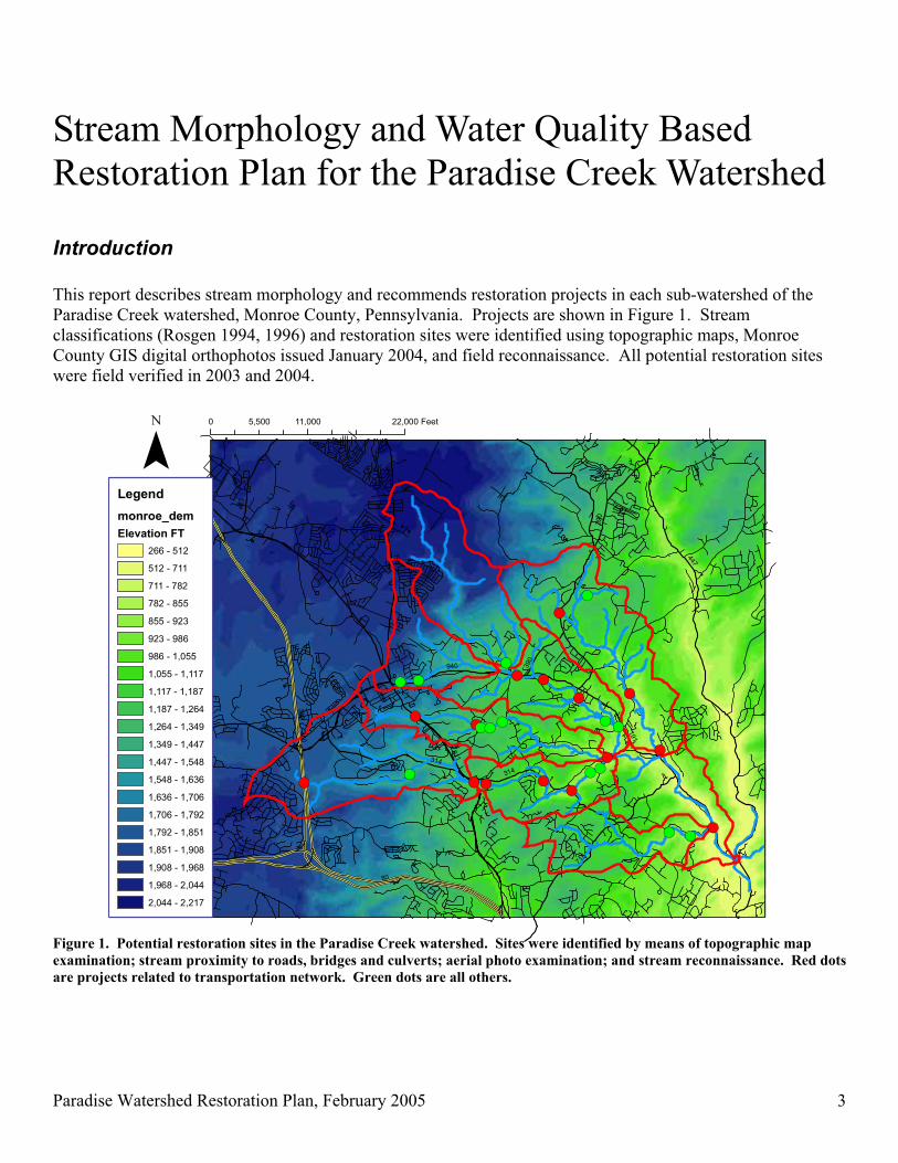
This report describes stream morphology and recommends restoration projects in each sub-watershed of the
Paradise Creek watershed, Monroe County, Pennsylvania. Projects are shown in Figure 1. Stream
classifications (Rosgen 1994, 1996) and restoration sites were identified using topographic maps, Monroe
County GIS digital orthophotos issued January 2004, and field reconnaissance. All potential restoration sites
were field verified in 2003 and 2004.
!(
!(!(!(
!(
!(!(!(!(
!( !(!(
!(!(!(
!(
!(
!(
!(
!(
!(
!(!(!(!(
!(
!(
!(
!(
191
80
447
380
19
6
715
611
314
423
940
390
940
38
0
314
80
390
0 11,000 22,0005,500 Feet
¯Legend
monroe_dem
Elevation FT
266 - 512
512 - 711
711 - 782
782 - 855
855 - 923
923 - 986
986 - 1,055
1,055 - 1,117
1,117 - 1,187
1,187 - 1,264
1,264 - 1,349
1,349 - 1,447
1,447 - 1,548
1,548 - 1,636
1,636 - 1,706
1,706 - 1,792
1,792 - 1,851
1,851 - 1,908
1,908 - 1,968
1,968 - 2,044
2,044 - 2,217
Figure 1. Potential restoration sites in the Paradise Creek watershed. Sites were identified by means of topographic map
examination; stream proximity to roads, bridges and culverts; aerial photo examination; and stream reconnaissance. Red dots
are projects related to transportation network. Green dots are all others.
Page 4
Paradise Watershed Restoration Plan, February 2005 4
Paradise Creek headwaters begin upon the Pocono Plateau in Mount Pocono Borough, and Barrett, Coolbaugh
and Tobyhanna Townships in Monroe County, Pennsylvania. Headwater streams flow steeply off of the plateau
into the Valley and Ridge physiographic province before joining with the main stem of Paradise Creek. The
Brodhead Watershed Association (2002) provided the following introductory description of the Paradise Creek
watershed. Draining approximately 44.5 square miles, Paradise Creek is about nine miles long, flowing in a
southeasterly direction through Paradise Township before joining Brodhead Creek. Most streams in the
watershed are closely paralleled by highways, but the riparian zone is mostly intact as much riparian land is
owned by fishing clubs. Major tributaries include Devils Hole Creek, Cranberry Creek, Butz Run, Swiftwater
Creek and Forest Hills Run. Paradise Creek boasts a healthy population of native and stocked trout. Streams in
the watershed are mostly high-gradient, with the exception of headwater streams atop the Pocono Plateau and
those streams within the main Paradise Creek valley bottom. Base flow is plentifully supplied by springs,
wetlands, and glacial overburden soils and geology. Devils Hole Creek, a tributary of the Paradise, is
designated as Exceptional Value by the Pennsylvania Department of Environmental Protection. The Paradise,
along with the Brodhead, is credited as the birthplace of American trout fishing tradition. Paradise Valley is
home to the first licensed trout hatchery in Pennsylvania.
Level I Stream Morphology of the Paradise Creek Watershed
Figure 1 displays relative elevations within the Paradise Creek watershed. Paradise Creek sub-watersheds begin
atop plateaus in relatively flat and wooded wetland areas, where valleys are wide and streams are very low
gradient with multiple small channels. Once channels become well-defined, they exhibit morphology of typical
low gradient C or E channels (Figure 2). Development in the watershed has taken place in these headwater
areas or in valley bottoms further downstream. In areas of transition between the Pocono Plateau and the
Valley and Ridge physiographic provinces, streams spill over an escarpment and enter steep sided and confined
V-shaped valleys. Streams in
the V-shaped valleys are
classified as high-gradient A or
B channels (Fig. 2). Within
these high-gradient stream
sections are numerous short,
shelf-like low-gradient stream
segments. These are wetland
areas perched within the
generally steep valleys.
Wherever a stream enters these
perched wetlands, the stream
forms multiple channels,
classified as natural D channels
(Fig. 2). Further downstream,
the stream gradient lessens and
the valleys widen into alluvial
valleys, where streams are no
longer confined within valley
walls and depositional soils
predominate along stream
channels. The meander belt Figure 2. Stream types (from Rosgen 1994, 1996).
Page 5
Paradise Watershed Restoration Plan, February 2005 5
width of most streams increases dramatically once the streams are no longer confined by steep-sided valleys.
Extensive and probably natural bank erosion was observed in stream segments transitioning from high to low
gradient. Dramatic examples of such erosion can be seen on Swiftwater Creek and Devils Hole Creek.
Consult the appendices for a more detailed description of Level I morphology. Appendix A contains
longitudinal elevation profiles of Paradise Creek and its tributary streams. Appendix B shows a MS Excel
workbook prepared for this study that contains a stream mileage system, various landmarks along stream
corridors, and all mapped stream segments with their local slope and predicted stream type. Most segments
were field verified by visual observation of stream pattern (Rosgen Level I analysis). Many remote locations
were missed by field reconnaissance and stream classification was predicted using only maps and aerial photos.
DRBC is completing a GIS layer of Paradise Watershed stream types linked to the National Hydrographic
Dataset (NHD). Computer files are available from DRBC upon request.
Stream Channel Stability Assessment and Restoration Opportunities
This survey of Paradise Creek watershed fluvial geomorphology was conducted to identify locations in the
watershed where streams are severely unstable. For this report, instability is defined as localized loss of
dynamic equilibrium of the stream channel. According to Pennsylvania’s Keystone Stream Team (2002) a
stream is “in equilibrium” or stable when it can carry the sediment load supplied by the watershed without
changing dimension (cross sectional area, width, depth, shape), pattern (sinuosity, meander pattern), or profile
(longitudinal pattern and slope) and without aggrading (building up of bottom materials) or degrading (incising
into the landscape and abandoning the natural floodplain). At the locations identified in this report, field
evidence of instability was verified by observation of channel evolution status (See Figure 3; Schumm, Harvey
and Watson 1984; Simon 1989, Simon and Downs 1995).
Figure 3. Channel Evolution Model (Schumm, Harvey and Watson
1984; field observation checklist adapted by Randy Sewell, VHB,
Inc., Williamsburg, VA)
Verification was performed according to methods described
by Thorne et al. (1997, 1998) and Rosgen (2001) and
included observation of severity and extent of stream
incision or degradation; extreme stream bank or point bar
erosion; excess sedimentation or aggradation through
interruption of natural sediment transport capacity; over-
widening of the channel relative to depth; channel braiding;
formation of mid-channel sediment bars; erosion of the
stream bed or head-cutting; and leaning or fallen old, large
trees. Localized effects of bridge crossings, culverts, dams,
stream bank stabilization projects, habitat improvement
structures, and some land uses include symptoms mentioned
above as well as blockage of fish passage. Many segments
of streams were identified where the riparian zone has been
reduced due to land use activities.
Diagnosis of instability was begun by visiting the
confluence locations of all streams in the watershed. At
Page 6
Paradise Watershed Restoration Plan, February 2005 6
these locations, field observation of the relative elevations of the stream beds helped to inform a diagnosis of
systemic aggradation or degradation, such as happens in the case of increased watershed imperviousness and
modification of the local hydrograph by stormwater runoff. Unless masked by incision due to channelization,
cumulative impacts were typically observed at these confluence points at the base of each sub-watershed.
Where both tributary channels are in dynamic equilibrium, the bed elevations typically match at the confluence
point. If they are not in equilibrium, then one channel was higher or lower than the other. Obvious differences
in bed elevations were identified at two locations: at the confluence of Swiftwater Creek and Forest Hills Run;
and at the confluence of Butz Run with Paradise Creek. The first may be due partially to systemic stormwater
impacts, though locally severe road and channelization impacts are also apparent; the second was due to
channelization of Paradise Creek during construction of Route 191 that parallels the stream. Once confluence
points were observed, all possible upstream sources of instability – both natural and man-made - were identified
during numerous field trips.
Before prioritization, there were about 260 potential restoration projects identified by map and aerial photo
examination. Most were discarded as candidates upon field verification, not due to absence of problems, but
because many of the problem areas were very localized and contained. Most unstable areas were in later stages
of channel evolution, where natural ‘healing’ of the stream channel is imminent. Many other sites were
unstable because of structures such as bridges, culverts, and small dams. Restoration projects near these might
serve to somewhat enhance aesthetics and habitat, but such projects might waste resources unless they address
the underlying causes of local instability – the bridges, culverts and dams. In the end, patching stream banks
didn’t count as true restoration opportunities. Thus the projects listed in this document are the top priorities
because total restoration can be completed or because instability is so severe that infrastructure is threatened.
Restoration is defined as the process of converting an unstable, altered, or degraded stream corridor,
including adjacent riparian zone and flood-prone areas to its natural or referenced, stable conditions
considering recent and future watershed conditions. This process also includes restoring the geomorphic dimension, pattern, and profile as well as biological and chemical integrity, including
transport of water and sediment produced by the stream’s watershed in order to achieve dynamic
equilibrium (Keystone Stream Team 2002).
Two categories of restoration opportunities are shown in the following watershed assessments: those projects
relating to the transportation network – road crossings, bridges, culverts, and close proximity of roads to
streams; and all other types of stream restoration or protection projects. Natural impacts were frequently
observed in transition areas between changing soil types, abrupt changes in stream gradient, bedrock outcrops
and other geological features, woody debris log jams, and confluence points of streams. Projects resulting from
natural instability were ignored unless homes or businesses located near these features require additional
protection or stream stabilization. Among the other types of restoration projects, objectives are meant to
mitigate man-made impacts such as: stream channelization (a well-known hydrologist appropriately refers to
this as ‘recreational bulldozing’); instream mining; ponds and reservoirs; landscape modification and addition
of impervious surfaces; ditching of wetlands; clearing away riparian buffer zones; building in floodplains;
disrupting continuity or heterogeneity of habitat; and other interruptions to the natural hydrologic processes of
the watershed. Since those who conduct these practices may unknowingly cause problems downstream, a most
beneficial project is education of landowners. Table 1 enumerates projects in each sub-watershed of the
Paradise Creek watershed.
Page 7
Paradise Watershed Restoration Plan, February 2005 7
Table 1. Number of potential stream restoration sites in the Paradise Creek watershed.
Source of Instability
Sub-Watershed Transportation Network Other Causes
Lower Paradise Creek 1 0
Butz Run 0 1
Cranberry Creek 3 1
Lower Swiftwater Creek 5 2
Upper Swiftwater Creek 1 1
Forest Hills Run 2 3
Upper Paradise Creek 3 2
Devils Hole Creek 1 0
Tank Creek & Yankee Run 0 2
TOTALS 16 12
There are many small projects that have not been listed. Educating and providing resources to landowners
about the importance of riparian buffers, native plants, and reduction of impervious surfaces can solve many of
the observed but small problems relating to land use in the vicinity of streams. Perhaps the Monroe County
Conservation District could provide technical assistance in the form of property audits for this purpose. Of
course, strong municipal ordinances and regulations can also help to solve these problems.
Another frequent and cumulatively important problem relates to the many ponds and small dams throughout the
watershed. During analysis of water quality data for the Paradise Creek watershed, it was observed that
temperature violations are fairly frequent in local waterways. Hundreds of small and shallow impoundments
were identified, and these may be a significant contributing factor to elevated temperatures in this important
trout fishery. Dams also interrupt fish passage. Future monitoring of water temperature should be conducted
upstream, within, and downstream of numerous ponds throughout the watershed, so that the extent of this
perceived problem can be quantified. Perhaps the Brodhead Watershed Association can obtain grant funds to
provide water temperature loggers to landowners for this purpose.
Dams also have strong impacts upon hydrologic processes and habitat. Impoundments disrupt sediment
transport processes and cause abrupt changes in transference of erosive forces from potential energy (the pond)
to kinetic energy (the spillway). Erosion was observed just downstream of most spillways. Many landowners
have attempted to build in-stream ponds in high-gradient streams, with drastic results. Numerous ponds were
observed to have completely filled with coarse sediment, which is the normal bedload sediment transported by
natural stream processes. The landowner’s maintenance headache includes expenditure of significant funds for
dredging and stabilizing the channel. The bigger the dam, the bigger the maintenance problem – see the Lake
Crawford dredging project as a case in point. As an example, one property owner on the high-gradient Devils
Hole Creek attempted to create a small impoundment which ultimately created a property threat. The pond
filled with cobble-sized sediment, and the stream channel was diverted by the sediment bar towards the stream’s
right bank, the owner’s driveway and main building. Stream processes are misunderstood or never even
considered by nearly all landowners, so education may save the landowners significant expense. As an
alternative to an in-stream structure, landowners could create a small diversion structure that sends floodwaters
toward an off-stream pond. This could save the continual dredging costs and providing some storage and
recharge benefit to the stream. In general, streams should not be dammed on their main channel, and this
especially applies to high gradient streams. Off-stream storage works better for both landowners and aquatic
life.
Page 8
Paradise Watershed Restoration Plan, February 2005 8
Restoration Options
Several factors were considered during prioritization of projects. First, the solutions should be appropriate to
the natural stream characteristics. There are many options. What works best, looks best, and costs least? For
example, rip-rap may be unsightly overkill for stabilization of low gradient streams, and bioengineering
techniques may be unsuitable in high-velocity streams. Some vendors now offer software providing menus of
restoration options according to stream and landscape characteristics. Rosgen (1996) provides a very useful
table of stream management characteristics according to observed stream types. The Society for Ecological
Restoration also provides excellent guidance for conception, organization, implementation, and assessment of
restoration projects (Clewell et al. 2000).
Second, unstable streams can naturally regain equilibrium over time if left alone, so it is possible, and in many
cases preferable, to let nature take its course. Examination of the channel evolution status of a stream reach
perceived as unstable may reveal that ‘healing’ is imminent. The ‘do nothing’ option should be the first
consideration. It is critical to ensure that upstream causes and processes are addressed if restoration efforts are
to succeed. Unfortunately many funding agencies want immediate action and will not pay for the data collection
necessary to verify upstream causes and quantify their effects. It is tempting to address the symptoms of
disequilibrium by patching one eroded stream bank, but restoration measures may repeatedly fail if upstream
conditions persist or worsen. Properties at high risk obviously get high priority for patching and stabilizing
stream banks, but this should be viewed as a temporary measure to be followed by more comprehensive
restoration. Using a comprehensive watershed view, it may be possible to save money by grouping a number of
contiguous sites into one restoration project.
Within a stream reach targeted for restoration, project planning takes place in consideration of the whole range
of hydrologic conditions: channel-forming flows, low flows, and flood conditions. This assessment of
equilibrium or natural stability of the stream channel took place by looking at characteristics of the stream
formed by the most effective channel-forming flood. This is typically the bankfull flood that occurs at a
frequency of about 2 of every 3 years. The bankfull flood is the key to popular natural stream channel design
techniques using instream structures constructed to ensure that the stream maintains dynamic equilibrium.
When assessing restoration options, however, the hydrologic extremes were also considered. How does the
stream channel ecologically function under extreme low-flow conditions? Is there a well-defined low-flow
channel? This is important for survival and movement of aquatic species such as the wild populations of trout
that inhabit streams of the Paradise Creek watershed. On the other hand, restoration measures tied to bankfull
are not meant to protect property damage resulting from larger floods. Hurricane Ivan hit the Paradise Creek
watershed in 2003, and extensive damage was observed that cannot be considered simple instability.
For the projects identified in the following watershed assessments, restoration or protection measures should
provide three main benefits:
1. Sustain fish passage, refuge and water quality during droughts by restoring habitat at low flow;
2. Maintain equilibrium of the stream channel by creating a natural bankfull flood channel; and
3. Protect homes and businesses from large floods by other means designed well above the bankfull elevation.
Page 9
Paradise Watershed Restoration Plan, February 2005 9
Recommendations
1. Gather reference reach data from Butz Run, an E channel, to serve as a design template for future natural
stream restoration of low-gradient streams throughout the Poconos. During Spring of 2005, the reference
reach will be measured by cooperative efforts of DRBC, MCCD, MCPC, and others using methods
described by Harrelson et. al (1994). Reference reach data will be analyzed using RiverMorph Stream
Restoration Software (RiverMorph, LLC, Louisville, KY), and distributed to relevant agencies and interested
parties.
2. Work with the PA Department of Transportation, Monroe County, and municipal road maintenance agencies
to install river-friendly bridges and culverts during future infrastructure maintenance and repair. This has
been done in some maintenance districts by members of the Keystone Stream Team.
3. Educate landowners about protection of the riparian corridor, stormwater impacts, and stream channel
maintenance. This can be completed as part of the Paradise Creek project or future grant-funded activity
(WREN grants, Coldwater Heritage grants, etc.)
4. Improve and share the assessment data set – this Level I survey only begins to document visual observations
throughout the watershed. Recommended ‘next steps’ would be: to collect detailed morphology of known
impacted and reference stream segments; improve the GIS layers for the stream network; conduct additional
aerial photo surveys; assemble partnerships to design and implement the restoration projects listed herein. It
is anticipated that surveys of many impacted segments will be conducted during restoration project
implementation throughout Pennsylvania, and these data should be shared among restoration practitioners. It
became obvious during this survey that the Commonwealth must improve GIS layers of the stream networks
– many unmapped channels were found, and those that have been digitized are highly inaccurate.
5. Implement more intensive water temperature monitoring within a program designed to reduce temperature
stress upon trout throughout the watershed. Funding can surely be found to provide water temperature
loggers (these are small, dependable, and inexpensive) to landowners. Such temperature data can be
assembled and analyzed to quantify and reduce the effects of impoundments, parking lot runoff, and reduced
riparian buffers upon water quality of the Paradise Creek. The objective of such an effort is to maintain a
healthy and viable trout population in the watershed, and to reduce the frequency of violation of PA water
quality standards, and to maintain or improve coldwater fisheries habitat. A similar effort has been
successfully implemented by the Pequannock River Coalition in northern New Jersey
(http://www.pequannockriver.org).
Page 10
Paradise Watershed Restoration Plan, February 2005 10
Lower Paradise Creek Sub-Watershed Potential Restoration Sites
!(
!(
!(
!(
!(
!(
!(
191
715
447
314
0 3,400 6,8001,700 Feet
¯
Figure 4 – Potential restoration sites in the Lower Paradise sub-watershed. Sites were identified by means of topographic map
examination; stream proximity within 150 feet of roads, bridges and culverts; aerial photo examination and field verification.
Restoration Projects
Road (1 red) Observation Action
1. Paradise Creek along Route 191 (4 segments): extensive
channelization. Improve habitat within incised channel.
Install habitat improvement structures.
Page 11
Paradise Watershed Restoration Plan, February 2005 11
Butz Run Sub-Watershed Potential Restoration Sites
!(
!(!(
!(
!(
!(
!(715
314191
0 4,000 8,0002,000 Feet
¯
Figure 5 – Potential restoration sites in the Butz Run sub-watershed. Sites were identified by means of topographic map
examination; stream proximity within 150 feet of roads, bridges and culverts; aerial photo examination and field verification.
Restoration Projects
Other (1 green) Observation Action
1. Butz Run in Parcel 3571 just upstream of forest and
abrupt gradient change entering hemlock valley.
Document reference reach morphology of E channel.
Page 12
Paradise Watershed Restoration Plan, February 2005 12
Cranberry Creek Sub-Watershed Potential Restoration Sites
!(!( !(
!(!(
!(
!(
!(
!(
!(
!(
!(
!(
!(
!(
191
447
940
390
611
390
0 5,500 11,0002,750 Feet
¯
Figure 6 – Potential restoration sites in the Cranberry Creek sub-watershed. Sites were identified by means of topographic
map examination; stream proximity within 150 feet of roads, bridges and culverts; aerial photo examination and field
verification.
Restoration Projects
Road (3 red) Observation Action
1. Cranberry Creek at Browns Hill Road crossing –
multiple culverts, blockages, undersized.
Road crossing is being renovated (proposed project as of
January 2005)
2. Cranberry Ck at Cranberry Creek Road crossing –
culvert effects.
Crossing frequently floods, culvert undersized. Road
runoff is potential problem. Possible project.
3. Cranberry Ck UNT7 (R) at Route 191 crossing –
culvert effects.
Road runoff should be captured and treated.
Other (1 green) Observation Action
4. Cranberry Ck (L) through parcel 8534 peat mining
operation, extreme channelization.
See 8534 Aerial Photo. Extensive disturbance of
stream channel, mitigation necessary once mining
operation is completed.
Page 13
Paradise Watershed Restoration Plan, February 2005 13
Figure 7 - Cranberry Creek at Browns Hill Road: culvert is
undersized, threatens road. Culvert should be replaced and
sized sufficiently to provide additional cross sectional area and
improve fish passage.
Figure 8 - Cranberry Creek at Cranberry Creek Road crossing.
Culvert undersized, road frequently floods. Stream receives a
large amount of road runoff. Non-point source pollution
management recommended here.
Figure 9 - Cranberry Creek at Route 191 crossing. This location
receives a large quantity of road runoff, which should be
managed to reduce introduction of pollutants to stream.
Page 14
Paradise Watershed Restoration Plan, February 2005 14
Figure 10 (left) and Figure
11 (below): headwaters of
Cranberry Creek watershed
at active peat mining
operation. Upon conclusion
of peat mining operations,
this site will require
extensive restoration. Little
is presently done to manage
water quality impacts at
this site.
Page 15
Paradise Watershed Restoration Plan, February 2005 15
Lower Swiftwater Creek Sub-Watershed Potential Restoration Sites
!(
!(
!(!( !(
!(
!(
!(
!(
!(
!(!(!(
314
611
715
191
314
611
0 3,300 6,6001,650 Feet
¯
Figure 12 – Potential restoration sites in the Lower Swiftwater Creek sub-watershed. Sites were identified by means of
topographic map examination; stream proximity within 150 feet of roads, bridges and culverts; aerial photo examination and
field verification.
Restoration Projects
Road (5 red) Observation Action
1. Swiftwater Creek at Parcel 0299 residential – bank gets
brunt of erosion effects from sharp turn in creek.
Landowner received disaster recovery funds for bank
stabilization. Habitat improvements needed.
2. Swiftwater Creek at Route 314 crossing – bridge effects. Large restoration project – up to 2 miles of stream
affected by backwater flooding & erosion.
3. Swiftwater Creek along Route 314 in Swiftwater, PA –
road is undermined.
Stabilization and habitat improvement recommended
(large project).
4. Swiftwater Creek at Aventis Pasteur – multiple crossings,
proximity to roads and parking lots.
Examine storm water runoff management at site,
potential future projects with Aventis (small project).
5. Swiftwater Creek at Route 611 – bridge and urban runoff. Manage highway runoff (small project).
Page 16
Paradise Watershed Restoration Plan, February 2005 16
Other (2 green) Observation Action
6. Swiftwater Creek at Lake Swiftwater outlet – dam effects. Install fish passage structure.
7. Swiftwater Creek upstream of Lake Swiftwater – bar
deposition, sediment transport interruption.
Detailed assessment from 314 to Lake Swiftwater,
perhaps restore as part of Rt. 314 project #2.
Figure 13: Lower Swiftwater Project 1:
Left bank erosion at confluence of Forest
Hills Run and Swiftwater Creek.
Landowner has received emergency
stabilization funding, but post-
stabilization habitat improvements and
perhaps upstream channel realignment
would improve instream conditions. This
site was previously channelized, creating
a 90-degree confluence of the streams and
producing these erosion effects.
Figure 14 - Lower Swiftwater Project #2: Swiftwater Creek upstream of Route 314 crossing – up to 2 miles of severe erosion.
Page 17
Paradise Watershed Restoration Plan, February 2005 17
Upper Swiftwater Creek Sub-Watershed Potential Restoration Sites
!(
!(
!(
!(!(
!(!(
!(
38
0
611
314
940
19
6
80
314
38
0
940
0 4,600 9,2002,300 Feet
¯
Figure 15 – Potential restoration sites in the Upper Swiftwater Creek sub-watershed. Sites were identified by means of
topographic map examination; stream proximity within 150 feet of roads, bridges and culverts; aerial photo examination and
field verification.
Restoration Projects
Road (1 red) Observation Action
1. Swiftwater Creek headwaters at I-380 N and S: manage
runoff from interstate road.
Install BMPs to capture road runoff.
Other (1 green) Observation Action
2. Swiftwater Creek at Ireland Hotels property – repair old
dam effects.
Old dams on property, 1 breached and 1 filled with
sediment. Investigate old diversion structure.
Possible project: remove small dam and improve
local habitat.
Page 18
Paradise Watershed Restoration Plan, February 2005 18
Forest Hills Run Sub-Watershed Potential Restoration Sites
!(!(!(
!(
!(!( !(
!(!(
!(
!(!(!(
!(
!(
!(
!(!(!(
!(
!(
!(
611
314
191
19
6
390
940
715
314
940
0 5,250 10,5002,625 Feet
¯
Figure 16 – Potential restoration sites in the Forest Hills Run sub-watershed. Sites were identified by means of topographic
map examination; stream proximity within 150 feet of roads, bridges and culverts; aerial photo examination and field
verification.
Restoration Projects
Road (2 red) Observation Action
1. Forest Hills Run at Route 611: culvert effects, road runoff. Install BMPs to manage road runoff.
2. Forest Hills Run at Mt Airy resort – near Woodland Rd
crossing and parking lot runoff.
Improve riparian zone, reduce runoff, manage geese.
Other (3 green) Observation Action
3. Forest Hills Run at Mt Airy Lake inlet – lawn, beach, no
riparian zone.
Manage runoff quality; establish riparian areas.
4. Forest Hills Run at Mt Airy Lake – no riparian zone, golf
course impacts, geese, resort runoff.
Establish riparian zone; reduce water quality effects
of turfgrass & fertilizers; reduce Canada Goose
impacts; prepare storm water plan for site.
Page 19
Paradise Watershed Restoration Plan, February 2005 19
Observation Action
5. Forest Hills Run at Mt Airy golf course DS of dam – high
velocity, channelization, no riparian zone, knotweed.
Establish riparian zone as environmentally sensitive
area on golf course; remove invasive plants;
reconstruct meanders if necessary (detailed survey to
determine erosive energy of stream, create
restoration plan).
Figure 17 – Forest Hills Run Projects 2,3,4,5: Mount Airy Lodge site, where improvements can be made to the riparian buffer,
storm water management for water quality, stream channelization repair, invasive species removal, and Canada Goose
management.
Photo 1 – Parking lot upstream of Woodland Road by Forest Hills Run
Photo 2 – Forest Hills Run enters Lake, see sediment deposit, extensive lawn and no buffer.
Photo 3 – Dam and Spillway of Lake, fish passage blocked.
Photo 4 – Downstream of Lake at golf course fairway – channelized, invasive species, poor buffer.
Page 20
Paradise Watershed Restoration Plan, February 2005 20
Upper Paradise Creek Sub-Watershed Potential Restoration Sites
!(
!(!( !(
!(
!(
!(
!(
!(
!(
!(
!(
!(
!(
191
940
390
611
314
611
0 3,900 7,8001,950 Feet
¯
Figure 18 – Potential restoration sites in the Upper Paradise Creek sub-watershed. Sites were identified by means of
topographic map examination; stream proximity within 150 feet of roads, bridges and culverts; aerial photo examination and
field verification.
Restoration Projects
Road (3 red) Observation Action
1. Paradise Creek upstream to downstream of Red Rock Rd
crossing – channel migration, incision, widening.
Large project - protect private property and stabilize
up to 1 mile of stream.
2. Paradise Creek in vicinity of abandoned Pocono Gardens
Resort – runoff, channelized, breached dam, road crossings.
Long channelized reach produces high energy
downstream. Improve habitat, reduce energy,
restore channel upstream of breached dam, create
stormwater management plan, install BMPs.
3. Paradise Creek at Route 940 – road effects, runoff. Address road runoff and runoff effects of stable.
Other (2 green) Observation Action
4. Paradise Creek at Crawford Lake dam – dam effects. Install fish passage structure. Implement lake
management recommendations.
5. Paradise Creek upstream of and entering Lake Crawford –
channelization, sediment bar, wandering channel into lake.
Install sediment capture forebay, maintain regularly.
Possible large restoration project to ½ mile upstream
of lake.
Page 21
Paradise Watershed Restoration Plan, February 2005 21
Figure 19 – Upper Paradise Project 1: Paradise Creek
from the vicinity of Red Rock Road to Lake Crawford.
Previously channelized, this reach is now widening,
forming meanders, and threatening private property.
Note the telephone pole in background, once about 15
feet from the stream, is now about to be undermined.
A more detailed assessment and restoration is
recommended from Red Rock Road to Lake
Crawford.
Figure 20 – Upper Paradise Project 2: Pocono Gardens Resort Site – upstream view of channelized section (above) and
downstream view past breached dam (right).
Page 22
Paradise Watershed Restoration Plan, February 2005 22
Figure 21 - Crawford Lake dredging, December 2004: Once the lake is dredged, a sediment forebay could be created for
future sediment capture and maintenance, and approximately ½ mile of upstream stabilization of Paradise Creek. Installation
of a fish passage structure and additional habitat improvements are recommended. Left – Downstream view toward dam.
Right – Upstream view of Paradise Creek entering Lake Crawford. Below – panoramic view of dredging project taken
February 2005.
Page 23
Paradise Watershed Restoration Plan, February 2005 23
Devils Hole Creek Sub-Watershed Potential Restoration Sites
!(
!(
19
6
611
191
390
940
191
0 4,800 9,6002,400 Feet
¯
Figure 22 – Potential restoration sites in the Devils Hole Creek sub-watershed. Sites were identified by means of topographic
map examination; stream proximity within 150 feet of roads, bridges and culverts; aerial photo examination and field-
verification.
Restoration Projects
Other (1 green) Observation Action
1. Devils Hole Creek at Paradise Stream resort – incision,
bank erosion, property threat, sediment in pond.
Major restoration and stabilization project.
Recommend dam removal at lower end of reach.
Page 24
Paradise Watershed Restoration Plan, February 2005 24
Figure 23 - Devils Hole Creek at upstream end of Ceasar’s Paradise Stream Resort. The stream has widened, eroding the
stream bank and creating a large bar. The erosion threatens part of the resort property. Emergency stabilization is necessary
at this location. Between this location and the dam downstream (see photos below), it is believed that the stream was
channelized at some time past. This part of the stream is located in the transition area between high-gradient mountainous
terrain and the low-gradient, wide valley of the Paradise Creek.
Figure 24 - Downstream view of sediment-filled small impoundment on Devils Hole Creek. The dam is just upstream of the footbridge in the background, and is located about 100 yards upstream of the confluence of Devils Hole Creek and Paradise Creek. Bank erosion to the right threatens a driveway and building. Dam removal is recommended at this location. Unless such impoundments are maintained frequently, installation of dams in high-energy stream environments is discouraged.
Page 25
Paradise Watershed Restoration Plan, February 2005 25
Tank Creek/Yankee Run Sub-Watershed Potential Restoration Sites
!(!(
!(
!(
196
611
940
940
0 3,500 7,0001,750 Feet
¯
Figure 25 – Potential restoration sites in the Tank Creek and Yankee Run sub-watershed. Sites were identified by means of
topographic map examination; stream proximity within 150 feet of roads, bridges and culverts; aerial photo examination and
field-verification.
Restoration Projects
Other (2 green dots) Observation Action
1. Yankee Run at pond upstream of Crestwood Drive – dam
effects, stormwater from development.
Stormwater management.
2. Yankee Run headwaters near Route 940, mall – receive
stormwater from mall?
Stormwater management.
Page 26
Paradise Watershed Restoration Plan, February 2005 26
References
Brodhead Watershed Association and Bloss Associates. 2002. Brodhead Watershed Conservation Plan.
Brodhead Watershed Association, Henryville, PA.
Clewell, A., J. Rieger, and J. Munro. 2000. A Society for Ecological Restoration Publication:
Guidelines for Developing and Managing Ecological Restoration Projects. Society for Ecological
Restoration, Tuscon, AZ. Document available via web at http://www.ser.org/reading_resources.asp
Harrelson, C.C., J.P. Potyondy, and C.L. Rawlins. 1994. Stream Channel Reference Sites: An Illustrated Guide
to Field Technique. General Technical Report RM-245, U.S. Department of Agriculture, Forest Service,
Fort Collins, CO.
Keystone Stream Team and Alliance for the Chesapeake Bay. 2003. Guidelines for Natural Stream Channel
Design for Pennsylvania Waterways. Canaan Valley Institute, Davis, WV. March 2003 edition accessed via
web at http://www.canaanvi.org
Rosgen, D.L. 1994. A classification of natural rivers. Catena 22: 169-199.
Rosgen, D.L. 1996. Applied River Morphology. Printed Media Companies, Minneapolis, MN.
Rosgen, D.L. 2001. A stream channel stability assessment methodology. In: Proceedings of the Seventh
International Sedimentation Conference, Reno, NV.
Schumm, S.A., M.D. Harvey and C.C. Watson. 1984. Incised Channels: Morphology, Dynamics and Control.
Water Resources Publications, Littleton, CO.
Simon, A. 1989. A model of channel response in disturbed alluvial channels. Earth Surface Processes and
Landforms 14(1): 11-26.
Simon, A. and P.W. Downs. 1995. An interdisciplinary approach to evaluation of potential instability in
alluvial channels. Geomorphology 12: 215-232.
Thorne, C.R., R.D. Hey, and M.D. Newson, eds. 1997. Applied Fluvial Geomorphology for River Engineering
and Management. John Wiley and Sons, New York.
Thorne, C.R. 1998. Stream Reconnaissance Handbook: Geomorphological Investigation and Analysis of River
Channels. John Wiley and Sons, Chichester, England. 133 p.
Page 27
Paradise Watershed Restoration Plan, February 2005 27
Appendix A: Longitudinal Profiles of Paradise Watershed Streams
Page 28
Paradise Watershed Restoration Plan, February 2005 28
Page 29
Paradise Watershed Restoration Plan, February 2005 29
Page 30
Paradise Watershed Restoration Plan, February 2005 30
Page 31
Paradise Watershed Restoration Plan, February 2005 31
Page 32
Paradise Watershed Restoration Plan, February 2005 32
Appendix B: Paradise Creek Watershed Stream Segments and Features.
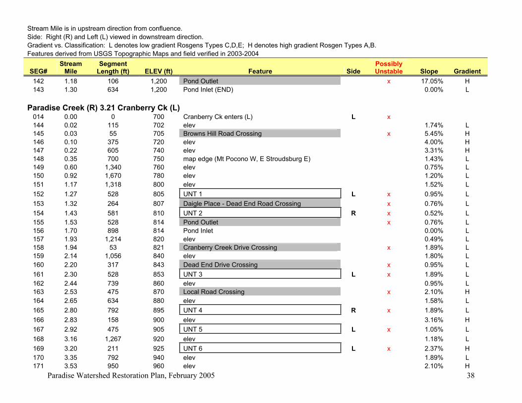
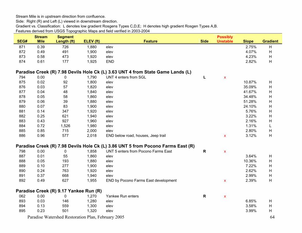
Explanation of Worksheet:
Stream Mile is in upstream direction from confluence.
Side: Right (R) and Left (L) viewed in downstream direction.
Gradient vs. Classification: L denotes low gradient Rosgens Types C,D,E; H denotes high gradient Rosgen
Types A,B.
Features derived from USGS topographic maps, aerial photos, and field verification in 2003-2004
SEG# - unique identifier of stream segment
STREAM MILE (mi) – stream mile location upstream from mouth.
SEGMENT LENGTH (ft) – length of stream segment in feet.
ELEV (ft) – elevation of upstream end of stream segment in feet.
FEATURE – name or description of stream feature or landmark along stream.
SIDE – viewed in downstream direction, side of stream where feature is found.
POSSIBLY UNSTABLE – x means that stream channel instability might be found here.
SLOPE – calculation of rise in elevation (ft) over run in segment length (ft) = percent slope of segment.
GRADIENT – H = high, Rosgen stream types A or B – slope greater than 2%
L = low, Rosgen stream types C, D, E – slope less than 2%
The following 1:24,000 scale USGS topographic maps were used to identify stream features in the Paradise
Creek Watershed:
!(
!(!(!(
!(
!(!(!(!(!( !(!(
!(!(!(
!(
!(
!(
!(
!(
!(
!(!(!(!(
!(
!(
!(
!(
80
191
38
0
447
423
19
6
715
611
940
314
209
390
42
3
80
715
940
38
0
447
314
39
0
SKYTOP
MOUNT POCONO
TOBYHANNA
POCONO PINES
BUCK HILL FALLS
EAST STROUDSBURG
0 13,000 26,0006,500 Feet
¯
Page 33
Paradise Watershed Restoration Plan, February 2005 33
Paradise Creek Watershed: Stream Segments and FeaturesStream Mile is in upstream direction from confluence.
Side: Right (R) and Left (L) viewed in downstream direction.
Gradient vs. Classification: L denotes low gradient Rosgens Types C,D,E; H denotes high gradient Rosgen Types A,B.
Features derived from USGS Topographic Maps and field verified in 2003-2004
SEG#Stream
MileSegment
Length (ft) ELEV (ft) Feature SidePossibly Unstable Slope Gradient
Paradise Creek (R)
000 0.00 0 575 Paradise Creek enters Brodhead R x
001 0.41 2,191 580 elev x 0.23% L
002 0.43 55 585 RR Br - Delaware Lackawanna x 9.09% H
003 0.54 583 587 elev 0.34% L
004 0.70 857 588 twp line 0.12% L
005 1.00 1,579 590 elev 0.13% L
006 1.02 121 594 Butz Run enters R x 3.32% H
007 1.36 1,795 620 elev 1.45% L
008 1.69 1,742 630 elev 0.57% L
009 1.88 1,003 650 Sylvan Cascade Rd x 1.99% L
010 1.94 317 660 elev 3.16% H
011 2.34 2,112 670 elev by 3 ponds (L) 0.47% L
012 2.42 422 680 Route 191 crossing x 2.37% H
013 2.72 1,584 690 elev by 715/191 int (L) Henryville 0.63% L
014 3.21 2,587 700 Cranberry Ck enters (L) L x 0.39% L
015 3.23 106 710 Route 191 crossing x 9.47% H
016 3.35 634 720 UNT 1 enters (Parkside) L x 1.58% L
017 3.49 739 720 elev 0.00% L
018 3.58 475 730 UNT 2 enters (Redrock) R x 2.10% H
019 3.73 792 740 elev 1.26% L
020 4.01 1,478 760 elev 1.35% L
021 4.28 1,426 780 elev (creek narrows at elev line) 1.40% L
022 4.44 845 790 Swiftwater Ck enters R x 1.18% L
023 4.52 422 795 Lower Swiftwater Rd Crossing x 1.18% L
024 4.60 422 800 elev 1.18% L
025 4.80 1,056 820 elev 1.89% L
026 4.90 528 840 Paradise Falls 3.79% H
027 5.02 634 850 elev 1.58% L
028 5.08 317 860 elev 3.16% H
029 5.10 106 870 Summit Drive / Falls Drive crossing x 9.47% H
Page 34
Paradise Watershed Restoration Plan, February 2005 34
Stream Mile is in upstream direction from confluence.
Side: Right (R) and Left (L) viewed in downstream direction.
Gradient vs. Classification: L denotes low gradient Rosgens Types C,D,E; H denotes high gradient Rosgen Types A,B.
Features derived from USGS Topographic Maps and field verified in 2003-2004
SEG#Stream
MileSegment
Length (ft) ELEV (ft) Feature SidePossibly Unstable Slope Gradient
030 5.20 528 880 DAM - Lake Crawford x 1.89% L
031 5.30 528 880 UNT 3 enters (Fish Hatchery) L x 0.00% L
032 5.40 528 880 UNT 4 enters (Fish Hatchery) L x 0.00% L
033 5.69 1,531 900 elev 1.31% L
034 5.71 106 900 UNT 5 enters (East of Mt Sophia) R x 0.00% L
035 6.05 1,795 920 elev 1.11% L
036 6.12 370 930 UNT 6 enters (Gravel Pit) R x 2.71% H
037 6.29 898 940 elev 1.11% L
038 6.41 634 950 Carlton Road Crossing x 1.58% L
039 6.47 317 960 elev 3.16% H
040 6.62 792 970 unknown crossing (?) x 1.26% L
041 6.79 898 980 elev 1.11% L
042 7.00 1,109 990 Keokee Chapel Lane Crossing x 0.90% L
043 7.07 370 1,000 elev 2.71% H
044 7.29 1,162 1,020 elev 1.72% L
045 7.57 1,478 1,040 elev 1.35% L
045a 7.60 158 1,050 UNT 7 enters (Pocono Mission School) L x 6.31% H
046 7.75 792 1,060 elev 1.26% L
047 7.76 53 1,060 Keokee Chapel Lane Crossing x 0.00% L
048 7.86 528 1,070 UNT 8 enters (by Grange Road) R 1.89% L
049 7.93 370 1,075 Route 940 Crossing x 1.35% L
050 7.98 264 1,080 Devils Hole Ck enters L 1.89% L
051 8.10 634 1,090 Unclassified Road crossing x 1.58% L
052 8.17 370 1,100 DAM X 2.71% H
053 8.27 528 1,120 elev 3.79% H
054 8.37 528 1,140 elev 3.79% H
055 8.39 106 1,143 Devils Hole Road Crossing x 2.84% H
056 8.55 845 1,160 elev 2.01% H
057 8.70 792 1,180 elev 2.53% H
058 8.85 792 1,200 elev 2.53% H
059 8.92 370 1,220 elev 5.41% H
060 9.01 475 1,240 elev 4.21% H
061 9.11 528 1,260 elev 3.79% H
Page 35
Paradise Watershed Restoration Plan, February 2005 35
Stream Mile is in upstream direction from confluence.
Side: Right (R) and Left (L) viewed in downstream direction.
Gradient vs. Classification: L denotes low gradient Rosgens Types C,D,E; H denotes high gradient Rosgen Types A,B.
Features derived from USGS Topographic Maps and field verified in 2003-2004
SEG#Stream
MileSegment
Length (ft) ELEV (ft) Feature SidePossibly Unstable Slope Gradient
062 9.17 317 1,270 Tank Creek enters L x 3.16% H
062 9.17 0 1,270 Yankee Run enters R
062 9.17 0 1,270 End Paradise Main Stem
48,418 675 1.39%
Paradise Creek (R) 1.02 Butz Run (R) 006 0.00 0 594 Butz Run confluence with Paradise Ck R x
063 0.06 320 600 elev 1.88% L
064 0.14 425 620 elev 4.71% H
065 0.17 159 640 elev 12.58% H
066 0.24 355 660 elev 5.63% H
067 0.32 405 680 elev 4.94% H
068 0.36 213 700 elev 9.39% H
069 0.40 245 720 elev 8.16% H
070 0.48 390 740 elev 5.13% H
071 0.56 427 760 elev 4.68% H
072 0.70 741 780 elev 2.70% H
073 0.76 307 800 elev 6.51% H
074 0.90 746 820 elev 2.68% H
075 1.02 653 840 elev 3.06% H
076 1.10 422 860 elev 4.73% H
077 1.31 1,109 880 elev 1.80% L
078 1.86 2,904 895 Dirt Road or Trail Crossing x 0.52% L
079 1.93 370 900 elev 1.35% L
080 2.09 845 920 elev 2.37% H
081 2.24 792 940 elev 2.53% H
082 2.29 264 945 Pond Outlet x 1.89% L
083 2.31 106 950 Route 314 Crossing x 4.73% H
084 2.37 317 960 elev 3.16% H
085 2.50 686 980 elev 2.91% H
086 2.64 739 1,000 elev 2.71% H
087 2.79 792 1,020 elev 2.53% H
088 2.86 370 1,030 UNT 1 (Meisertown) enters L x 2.71% H
089 2.88 106 1,032 Pond Outlet x 1.89% L
Page 36
Paradise Watershed Restoration Plan, February 2005 36
Stream Mile is in upstream direction from confluence.
Side: Right (R) and Left (L) viewed in downstream direction.
Gradient vs. Classification: L denotes low gradient Rosgens Types C,D,E; H denotes high gradient Rosgen Types A,B.
Features derived from USGS Topographic Maps and field verified in 2003-2004
SEG#Stream
MileSegment
Length (ft) ELEV (ft) Feature SidePossibly Unstable Slope Gradient
090 2.98 528 1,040 elev 1.52% L
091 3.10 634 1,060 elev 3.16% H
092 3.24 739 1,080 elev 2.71% H
093 3.38 739 1,100 elev 2.71% H
094 3.39 53 1,103 Freeland Pond Outlet x 5.68% H
095 3.47 422 1,105 UNT 2 (small pond) enters Freeland Pond L 0.47% L
096 3.56 475 1,105 Alpine Lake Trib enters Freeland Pond L 0.00% L
097 3.58 106 1,105 Freeland Pond Inlet 0.00% L
098 3.63 264 1,108 Route 715 Crossing x 1.14% L
099 3.65 106 1,109 Road Crossing (in development) x 0.95% L
100 3.68 158 1,110 Pond Outlet x 0.63% L
101 3.74 317 1,110 Pond Inlet 0.00% L
102 3.77 158 1,115 Road Crossing (in development) x 3.16% H
103 3.81 211 1,120 elev 2.37% H
104 3.89 422 1,125 Road Crossing (in development) x 1.18% L
105 4.10 1,109 1,140 elev 1.35% L
106 4.11 53 1,141 Pond Outlet x 1.89% L
107 4.24 686 1,141 Pond Inlet 0.00% L
108 4.26 106 1,145 Pond Outlet x 3.79% H
109 4.44 950 1,145 Pond Inlet (END) 0.00% L
23,443 551 2.53% H
Paradise Creek (R) 1.02 Butz Run (R) 2.86 UNT 1 from Meisertown (L) 088 0.00 0 1,030 UNT 1 (Meisertown) enters Paradise Ck L x
110 0.10 527 1,035 Road Crossing (near Cherry Ln & SR 1002) x 0.95% L
111 0.13 165 1,040 elev 3.03% H
112 0.14 61 1,042 Pond Outlet x 3.28% H
113 0.18 181 1,043 Pond Inlet 0.55% L
114 0.31 710 1,060 elev 2.39% H
115 0.46 771 1,075 Route 715 Crossing x 1.95% L
116 0.47 77 1,080 Pond Outlet x 6.49% H
117 0.60 671 1,080 UNT 1 enters Pond R 0.00% L
118 0.70 525 1,080 Pond Inlet 0.00% L
119 0.73 140 1,085 Route 314 Crossing x 3.57% H
Page 37
Paradise Watershed Restoration Plan, February 2005 37
Stream Mile is in upstream direction from confluence.
Side: Right (R) and Left (L) viewed in downstream direction.
Gradient vs. Classification: L denotes low gradient Rosgens Types C,D,E; H denotes high gradient Rosgen Types A,B.
Features derived from USGS Topographic Maps and field verified in 2003-2004
SEG#Stream
MileSegment
Length (ft) ELEV (ft) Feature SidePossibly Unstable Slope Gradient
120 0.75 149 1,088 UNT 2 enters L x 2.01% H
121 0.85 517 1,093 Road Crossing (driveway?) x 0.97% L
122 0.91 335 1,095 Pond Outlet x 0.60% L
123 0.94 154 1,095 Pond Inlet 0.00% L
124 0.97 160 1,097 Route 314 Crossing x 1.25% L
125 0.99 102 1,098 END 0.98% L
Paradise Creek (R) 1.02 Butz Run (R) 2.86 UNT 1 from Meisertown (L) 0.60 UNT1 to Pond (R)
117 0.00 0 1,080 UNT 1 enters Pond R x
126 0.07 390 1,090 Pond Outlet x 2.56% H
127 0.09 99 1,090 Pond Inlet (END) 0.00% L
Paradise Creek (R) 1.02 Butz Run (R) 2.86 UNT 1 from Meisertown (L) 0.75 UNT2 (L) 120 0.00 0 1,088 UNT 2 enters L x
128 0.08 413 1,090 Pond Outlet x 0.48% L
129 0.14 304 1,090 Pond Inlet (END) 0.00% L
Paradise Creek (R) 1.02 Butz Run (R) 3.47 UNT 2 from Small Pond to Freeland Pond (L) 095 0.00 0 1,105 UNT 2 (small pond) enters Freeland Pond L x
130 0.02 112 1,110 Pond Outlet x 4.46% H
131 0.04 84 1,110 Pond Inlet (END) 0.00% L
Paradise Creek (R) 1.02 Butz Run (R) 3.56 Alpine Lake Trib to Freeland Pond (L) 096 0.00 0 1,105 Alpine Lake Trib enters Freeland Pond L x
132 0.04 224 1,110 Route 715 Crossing 2.23% H
133 0.23 971 1,120 elev 1.03% L
134 0.30 397 1,125 Camelback Drive Crossing x 1.26% L
135 0.32 99 1,128 Alpiine Lake Outlet x 3.03% H
136 0.72 2,087 1,129 Alpine Lake Inlet 0.05% L
137 0.86 777 1,140 elev 1.42% L
138 0.89 125 1,143 Hillside Drive Crossing x 2.40% H
139 1.05 864 1,160 elev 1.97% L
140 1.13 422 1,180 elev 4.73% H
141 1.16 158 1,182 Road and Power Line Crossing x 1.26% L
Page 38
Paradise Watershed Restoration Plan, February 2005 38
Stream Mile is in upstream direction from confluence.
Side: Right (R) and Left (L) viewed in downstream direction.
Gradient vs. Classification: L denotes low gradient Rosgens Types C,D,E; H denotes high gradient Rosgen Types A,B.
Features derived from USGS Topographic Maps and field verified in 2003-2004
SEG#Stream
MileSegment
Length (ft) ELEV (ft) Feature SidePossibly Unstable Slope Gradient
142 1.18 106 1,200 Pond Outlet x 17.05% H
143 1.30 634 1,200 Pond Inlet (END) 0.00% L
Paradise Creek (R) 3.21 Cranberry Ck (L) 014 0.00 0 700 Cranberry Ck enters (L) L x
144 0.02 115 702 elev 1.74% L
145 0.03 55 705 Browns Hill Road Crossing x 5.45% H
146 0.10 375 720 elev 4.00% H
147 0.22 605 740 elev 3.31% H
148 0.35 700 750 map edge (Mt Pocono W, E Stroudsburg E) 1.43% L
149 0.60 1,340 760 elev 0.75% L
150 0.92 1,670 780 elev 1.20% L
151 1.17 1,318 800 elev 1.52% L
152 1.27 528 805 UNT 1 L x 0.95% L
153 1.32 264 807 Daigle Place - Dead End Road Crossing x 0.76% L
154 1.43 581 810 UNT 2 R x 0.52% L
155 1.53 528 814 Pond Outlet x 0.76% L
156 1.70 898 814 Pond Inlet 0.00% L
157 1.93 1,214 820 elev 0.49% L
158 1.94 53 821 Cranberry Creek Drive Crossing x 1.89% L
159 2.14 1,056 840 elev 1.80% L
160 2.20 317 843 Dead End Drive Crossing x 0.95% L
161 2.30 528 853 UNT 3 L x 1.89% L
162 2.44 739 860 elev 0.95% L
163 2.53 475 870 Local Road Crossing x 2.10% H
164 2.65 634 880 elev 1.58% L
165 2.80 792 895 UNT 4 R x 1.89% L
166 2.83 158 900 elev 3.16% H
167 2.92 475 905 UNT 5 L x 1.05% L
168 3.16 1,267 920 elev 1.18% L
169 3.20 211 925 UNT 6 L x 2.37% H
170 3.35 792 940 elev 1.89% L
171 3.53 950 960 elev 2.10% H
Page 39
Paradise Watershed Restoration Plan, February 2005 39
Stream Mile is in upstream direction from confluence.
Side: Right (R) and Left (L) viewed in downstream direction.
Gradient vs. Classification: L denotes low gradient Rosgens Types C,D,E; H denotes high gradient Rosgen Types A,B.
Features derived from USGS Topographic Maps and field verified in 2003-2004
SEG#Stream
MileSegment
Length (ft) ELEV (ft) Feature SidePossibly Unstable Slope Gradient
172 3.66 686 980 elev 2.91% H
173 3.78 634 1,000 elev 3.16% H
174 3.97 1,003 1,020 elev 1.99% L
175 4.09 634 1,035 UNT 7 R x 2.37% H
176 4.14 264 1,040 elev 1.89% L
177 4.33 1,003 1,060 elev 1.99% L
178 4.45 634 1,080 elev 3.16% H
179 4.52 370 1,100 elev 5.41% H
180 4.66 739 1,120 elev 2.71% H
181 4.76 528 1,135 UNT 8 L x 2.84% H
182 4.80 211 1,140 elev 2.37% H
183 4.94 739 1,160 elev 2.71% H
184 5.11 898 1,175 Erie-Lackawanna Railroad Crossing x 1.67% L
185 5.14 158 1,177 Sand Spring Dr Crossing x 1.26% L
186 5.22 422 1,180 elev 0.71% L
187 5.23 53 1,182 Pond Outlet (by 191) x 3.79% H
188 5.41 950 1,183 Pond Inlet 0.11% L
189 5.91 2,640 1,190 END by development x 0.27% L
31,205 490 1.57% L
Paradise Creek (R) 3.21 Cranberry Ck (L) 1.27 UNT 1 (L) 152 0.00 0 805 UNT 1 L x
190 0.12 614 810 Pond Outlet x 0.81% L
191 0.22 556 811 Pond Inlet 0.18% L
192 0.23 65 817 END 9.23% H
Paradise Creek (R) 3.21 Cranberry Ck (L) 1.43 UNT 2 (R) 154 0.00 0 810 UNT 2 R x
193 0.12 659 815 Local Road Crossing x 0.76% L
194 0.15 142 817 Wetland Outlet x 1.41% L
195 0.33 966 819 Wetland Inlet (END) 0.21% L
Page 40
Paradise Watershed Restoration Plan, February 2005 40
Stream Mile is in upstream direction from confluence.
Side: Right (R) and Left (L) viewed in downstream direction.
Gradient vs. Classification: L denotes low gradient Rosgens Types C,D,E; H denotes high gradient Rosgen Types A,B.
Features derived from USGS Topographic Maps and field verified in 2003-2004
SEG#Stream
MileSegment
Length (ft) ELEV (ft) Feature SidePossibly Unstable Slope Gradient
Paradise Creek (R) 3.21 Cranberry Ck (L) 2.30 UNT 3 (L) 161 0.00 0 853 UNT 3 L x
196 0.04 190 860 elev 3.68% H
197 0.05 53 862 Cranberry Creek Drive Crossing x 3.77% H
198 0.08 163 875 UNT 1 L x 7.98% H
199 0.11 187 880 elev 2.67% H
200 0.17 282 900 elev 7.09% H
201 0.22 283 920 elev 7.07% H
202 0.26 217 940 elev 9.22% H
203 0.27 35 942 Small Pond #3 Outlet x 5.71% H
204 0.28 47 942 Small Pond #3 Inlet 0.00% L
205 0.29 50 945 Small Pond #2 Outlet x 6.00% H
206 0.30 51 945 Small Pond #2 Inlet 0.00% L
207 0.30 47 948 Small Pond #1 Outlet x 6.38% H
208 0.32 77 948 Small Pond #1 Inlet 0.00% L
209 0.36 242 960 elev 4.96% H
210 0.42 283 978 Erie Lackawanna Railroad Crossing x 6.36% H
211 0.46 199 980 elev 1.01% L
212 0.46 41 982 4WD Trail Crossing x 4.88% H
213 0.52 317 1,000 elev 5.68% H
214 0.57 270 1,005 Wetland Outlet x 1.85% L
215 0.70 645 1,010 Wetland Inlet 0.78% L
216 0.79 467 1,020 elev 2.14% H
217 0.90 627 1,040 elev 3.19% H
218 0.98 399 1,050 END 2.51% H
Paradise Creek (R) 3.21 Cranberry Ck (L) 2.30 UNT 3 (L) 0.08 UNT 1 (L) 198 0.00 0 875 UNT 1 L x
219 0.13 696 880 elev 0.72% L
220 0.22 442 900 elev 4.52% H
221 0.35 694 920 elev 2.88% H
222 0.38 193 940 elev 10.36% H
223 0.42 186 950 Erie Lackawanna Railroad Crossing x 5.38% H
224 0.46 216 960 4WD Trail Crossing x 4.63% H
Page 41
Paradise Watershed Restoration Plan, February 2005 41
Stream Mile is in upstream direction from confluence.
Side: Right (R) and Left (L) viewed in downstream direction.
Gradient vs. Classification: L denotes low gradient Rosgens Types C,D,E; H denotes high gradient Rosgen Types A,B.
Features derived from USGS Topographic Maps and field verified in 2003-2004
SEG#Stream
MileSegment
Length (ft) ELEV (ft) Feature SidePossibly Unstable Slope Gradient
225 0.52 309 980 elev 6.47% H
226 0.57 281 1,000 elev 7.12% H
227 0.68 599 1,005 4WD Trail Crossing x 0.83% L
228 0.71 119 1,007 Wetland Outlet x 1.68% L
229 0.98 1,465 1,010 Wetland Inlet (END) 0.20% L
Paradise Creek (R) 3.21 Cranberry Ck (L) 2.80 UNT 4 (R) 165 0.00 0 895 UNT 4 R x
230 0.01 69 900 elev 7.25% H
231 0.09 385 920 elev 5.19% H
232 0.14 305 930 Pond Outlet (side channel pond?) x 3.28% H
233 0.16 96 930 Pond Inlet 0.00% L
234 0.21 238 940 Pond Outlet x 4.20% H
235 0.27 336 940 Pond Inlet 0.00% L
236 0.29 91 945 Road Crossing (driveway) x 5.49% H
237 0.30 43 950 Pond Outlet x 11.63% H
238 0.33 164 950 Pond Inlet (END) 0.00% L
Paradise Creek (R) 3.21 Cranberry Ck (L) 2.92 UNT 5 (L) 167 0.00 0 905 UNT 5 L x
239 0.13 699 920 elev 2.15% H
240 0.15 102 940 elev 19.61% H
241 0.18 150 960 elev 13.33% H
242 0.20 118 980 elev 16.95% H
243 0.22 81 1,000 elev 24.69% H
244 0.26 231 1,018 Delaware Lackawanna Railroad Crossing x 7.79% H
245 0.29 144 1,020 elev 1.39% L
246 0.31 101 1,030 4WD Trail Crossing x 9.90% H
247 0.34 171 1,040 elev 5.85% H
248 0.40 333 1,060 elev 6.01% H
249 0.46 307 1,080 elev 6.51% H
250 0.53 373 1,100 elev 5.36% H
251 0.61 422 1,120 elev 4.74% H
252 0.72 568 1,140 elev (END) 3.52% H
Page 42
Paradise Watershed Restoration Plan, February 2005 42
Stream Mile is in upstream direction from confluence.
Side: Right (R) and Left (L) viewed in downstream direction.
Gradient vs. Classification: L denotes low gradient Rosgens Types C,D,E; H denotes high gradient Rosgen Types A,B.
Features derived from USGS Topographic Maps and field verified in 2003-2004
SEG#Stream
MileSegment
Length (ft) ELEV (ft) Feature SidePossibly Unstable Slope Gradient
Paradise Creek (R) 3.21 Cranberry Ck (L) 3.20 UNT 6 (L) 169 0.00 0 925 UNT 6 L x
253 0.06 326 940 elev 4.60% H
254 0.09 128 960 elev 15.63% H
255 0.11 150 980 elev 13.33% H
256 0.15 166 1,000 elev 12.05% H
257 0.20 260 1,018 Railroad Crossing x 6.92% H
258 0.23 167 1,020 4WD Trail Crossing x 1.20% L
259 0.32 468 1,040 elev 4.27% H
260 0.52 1,062 1,060 elev 1.88% L
261 0.66 743 1,080 elev 2.69% H
262 0.74 451 1,100 elev 4.43% H
263 0.76 84 1,103 Trail Crossing x 3.57% H
264 0.89 720 1,118 END 2.08% H
Paradise Creek (R) 3.21 Cranberry Ck (L) 4.09 UNT 7 (R) 175 0.00 0 1,035 UNT 7 R x
265 0.06 304 1,040 elev 1.64% L
266 0.17 585 1,060 elev 3.42% H
266a 0.35 961 1,075 Snow Bird Lane crossing in development x 1.56% L
267 0.37 117 1,080 elev 4.27% H
268 0.51 737 1,100 elev 2.71% H
269 0.55 197 1,120 elev 10.15% H
270 0.58 144 1,140 elev 13.89% H
271 0.60 102 1,150 Route 191 Crossing x 9.80% H
272 0.64 215 1,160 elev 4.65% H
273 0.70 355 1,170 Pond Outlet x 2.82% H
274 0.79 472 1,171 Pond Inlet 0.21% L
275 0.89 490 1,180 elev 1.84% L
276 1.05 865 1,200 elev 2.31% H
277 1.08 158 1,207 Railroad Crossing x 4.42% H
278 1.10 106 1,210 Hardytown Road Crossing x 2.84% H
279 1.16 317 1,220 elev 3.16% H
Page 43
Paradise Watershed Restoration Plan, February 2005 43
Stream Mile is in upstream direction from confluence.
Side: Right (R) and Left (L) viewed in downstream direction.
Gradient vs. Classification: L denotes low gradient Rosgens Types C,D,E; H denotes high gradient Rosgen Types A,B.
Features derived from USGS Topographic Maps and field verified in 2003-2004
SEG#Stream
MileSegment
Length (ft) ELEV (ft) Feature SidePossibly Unstable Slope Gradient
279a 1.30 739 1,230 Driveway Crossing x 1.35% L
280 1.50 1,056 1,240 elev 0.95% L
281 1.66 845 1,260 elev 2.37% H
282 1.70 211 1,280 elev 9.47% H
283 1.76 317 1,300 elev 6.31% H
284 1.82 317 1,320 elev 6.31% H
285 1.89 370 1,340 elev 5.41% H
286 1.96 370 1,360 elev 5.41% H
287 2.00 211 1,380 elev 9.47% H
288 2.01 53 1,383 Dirt Road Crossing x 5.68% H
289 2.04 158 1,400 elev 10.73% H
290 2.13 475 1,420 elev 4.21% H
291 2.21 422 1,440 elev 4.73% H
292 2.26 264 1,460 elev 7.58% H
293 2.30 211 1,480 elev (END near dirt road) x 9.47% H
Paradise Creek (R) 3.21 Cranberry Ck (L) 4.76 UNT 8 (L) 181 0.00 0 1,135 UNT 8 L x
294 0.03 140 1,140 elev 3.57% H
295 0.10 407 1,155 UNT 1 R x 3.69% H
296 0.12 83 1,160 elev (RR Berm) x 6.02% H
297 0.14 91 1,160 Railroad Crossing x 0.00% L
298 0.43 1,559 1,170 Peat Mine outlet. x 0.64% L
299 0.87 2,314 1,180 elev in Wetland 0.43% L
300 0.92 246 1,181 Dirt Road Crossing x 0.41% L
301 1.02 546 1,184 END in Peat Mine. 0.55% L
Paradise Creek (R) 3.21 Cranberry Ck (L) 4.76 UNT 8 (L) 0.10 UNT 1 (R)
295 0.00 0 1,155 UNT 1 R x
302 0.13 694 1,160 Railroad Crossing x
303 0.27 732 1,166 Wetland Outlet x 0.82% L
304 0.39 648 1,167 END in Peat mine. 0.15% L
Page 44
Paradise Watershed Restoration Plan, February 2005 44
Stream Mile is in upstream direction from confluence.
Side: Right (R) and Left (L) viewed in downstream direction.
Gradient vs. Classification: L denotes low gradient Rosgens Types C,D,E; H denotes high gradient Rosgen Types A,B.
Features derived from USGS Topographic Maps and field verified in 2003-2004
SEG#Stream
MileSegment
Length (ft) ELEV (ft) Feature SidePossibly Unstable Slope Gradient
Paradise Creek (R) 3.35 UNT 1 Parkside (L) 016 0.00 0 720 UNT 1 enters (Parkside) L x
305 0.02 130 740 Road Crossing x 15.38% H
306 0.04 66 742 Pond Outlet x 3.03% H
307 0.09 305 742 Pond Inlet (END near Route 191) x 0.00% L
Paradise Creek (R) 3.58 UNT 2 Redrock (R) - POTENTIAL REFERENCE STREAM
018 0.00 0 730 UNT 2 enters (Redrock Glen) R x
308 0.02 94 740 elev 10.64% H
309 0.04 92 760 elev 21.74% H
310 0.08 221 780 elev 9.05% H
311 0.13 270 800 elev 7.41% H
312 0.16 194 820 elev 10.31% H
313 0.19 151 840 elev 13.25% H
314 0.22 139 860 elev 14.39% H
315 0.25 165 880 elev 12.12% H
316 0.28 132 900 elev 15.15% H
317 0.30 106 920 elev 18.87% H
318 0.32 120 940 elev 16.67% H
319 0.33 74 960 elev 27.03% H
320 0.36 130 980 elev 15.38% H
321 0.38 134 1,000 elev 14.93% H
322 0.41 157 1,020 elev 12.74% H
323 0.46 234 1,040 elev 8.55% H
324 0.54 457 1,060 elev 4.38% H
325 0.57 144 1,065 END 3.47% H
3,014 335 11.11% H
Paradise Creek (R) 4.44 Swiftwater Ck (R) 022 0.00 0 790 Swiftwater Ck R x
326 0.09 464 795 Forest Hills Run L x 1.08% L
327 0.15 308 798 channel splits x 0.97% L
328 0.20 293 800 elev 0.68% L
Page 45
Paradise Watershed Restoration Plan, February 2005 45
Stream Mile is in upstream direction from confluence.
Side: Right (R) and Left (L) viewed in downstream direction.
Gradient vs. Classification: L denotes low gradient Rosgens Types C,D,E; H denotes high gradient Rosgen Types A,B.
Features derived from USGS Topographic Maps and field verified in 2003-2004
SEG#Stream
MileSegment
Length (ft) ELEV (ft) Feature SidePossibly Unstable Slope Gradient
329 0.27 383 815 Road Crossing x 3.92% H
330 0.30 144 820 elev 3.47% H
331 0.39 469 840 elev 4.26% H
332 0.41 82 842 Swiftwater Lake Outlet x 2.44% H
333 0.64 1,222 843 Swiftwater Lake Inlet 0.08% L
334 0.96 1,704 860 elev 1.00% L
335 1.12 845 875 UNT 1 enters R x 1.78% L
336 1.21 475 878 Road Crossing x 0.63% L
337 1.25 211 880 elev 0.95% L
338 1.53 1,478 900 elev 1.35% L
339 1.72 1,003 920 elev 1.99% L
340 1.80 422 930 UNT 2 enters R x 2.37% H
341 1.95 792 940 elev 1.26% L
342 2.05 528 955 UNT 3 enters L x 2.84% H
343 2.11 317 960 elev 1.58% L
344 2.13 106 962 Road Crossing x 1.89% L
345 2.35 1,162 980 elev 1.55% L
346 2.46 581 990 Road Crossing x 1.72% L
347 2.64 950 1,000 Road Crossing x 1.05% L
348 2.77 686 1,020 elev 2.91% H
349 2.96 1,003 1,040 elev 1.99% L
350 3.25 1,531 1,060 elev 1.31% L
351 3.46 1,109 1,080 elev 1.80% L
352 3.47 53 1,081 UNT 4 enters R x 1.89% L
353 3.66 1,003 1,100 elev 1.89% L
354 3.77 581 1,120 Road Crossing x 3.44% H
355 3.90 686 1,138 Road Crossing x 2.62% H
356 3.97 370 1,140 elev 0.54% L
357 4.04 370 1,155 UNT 5 enters R x 4.06% H
358 4.10 317 1,160 elev 1.58% L
359 4.23 686 1,180 elev 2.91% H
360 4.35 634 1,200 elev 3.16% H
361 4.37 106 1,202 Route 314 Crossing x 1.89% L
Page 46
Paradise Watershed Restoration Plan, February 2005 46
Stream Mile is in upstream direction from confluence.
Side: Right (R) and Left (L) viewed in downstream direction.
Gradient vs. Classification: L denotes low gradient Rosgens Types C,D,E; H denotes high gradient Rosgen Types A,B.
Features derived from USGS Topographic Maps and field verified in 2003-2004
SEG#Stream
MileSegment
Length (ft) ELEV (ft) Feature SidePossibly Unstable Slope Gradient
362 4.49 634 1,215 UNT 6 enters L x 2.05% H
363 4.62 686 1,220 elev 0.73% L
364 4.83 1,109 1,240 elev 1.80% L
365 4.99 845 1,260 elev 2.37% H
366 5.02 158 1,265 Indian Run L x 3.16% H
367 5.09 370 1,280 elev 4.06% H
368 5.15 317 1,300 elev 6.31% H
369 5.19 211 1,310 Route 314 Crossing x 4.73% H
370 5.28 475 1,320 elev 2.10% H
371 5.39 581 1,340 elev 3.44% H
372 5.52 686 1,360 elev 2.91% H
373 5.60 422 1,380 Lake Minausin Outlet x 4.73% H
374 5.74 739 1,381 Lake Minausin Inlet 0.14% L
375 6.00 1,373 1,400 elev 1.38% L
376 6.11 581 1,420 elev 3.44% H
377 6.23 634 1,440 elev 3.16% H
378 6.40 898 1,460 elev 2.23% H
379 6.42 106 1,463 Dirt Road Crossing x 2.84% H
380 6.56 739 1,480 elev 2.30% H
381 6.69 686 1,500 elev 2.91% H
382 6.76 370 1,520 elev 5.41% H
383 6.87 581 1,540 elev 3.44% H
384 6.98 581 1,560 elev 3.44% H
385 7.10 634 1,580 elev 3.16% H
386 7.30 1,056 1,600 elev 1.89% L
387 7.43 686 1,620 elev 2.91% H
388 7.59 845 1,640 elev 2.37% H
389 7.77 950 1,660 elev 2.10% H
390 7.85 422 1,675 UNT 7 enters from Pocono Summit R x 3.55% H
391 7.90 264 1,680 elev 1.89% L
392 8.02 634 1,700 elev 3.16% H
393 8.06 211 1,710 Trail Crosssing x 4.73% H
394 8.13 370 1,720 elev 2.71% H
395 8.16 158 1,725 I-380 Northbound Crossing x 3.16% H
Page 47
Paradise Watershed Restoration Plan, February 2005 47
Stream Mile is in upstream direction from confluence.
Side: Right (R) and Left (L) viewed in downstream direction.
Gradient vs. Classification: L denotes low gradient Rosgens Types C,D,E; H denotes high gradient Rosgen Types A,B.
Features derived from USGS Topographic Maps and field verified in 2003-2004
SEG#Stream
MileSegment
Length (ft) ELEV (ft) Feature SidePossibly Unstable Slope Gradient
396 8.21 264 1,735 I-380 Southbound Crossing x 3.79% H
397 8.25 211 1,740 elev 2.37% H
398 8.31 317 1,760 elev 6.31% H
399 8.39 422 1,780 elev 4.73% H
400 8.44 264 1,800 elev 7.58% H
401 8.56 634 1,805 Wetland Outlet x 0.79% L
402 8.79 1,214 1,810 Wetland begins (END) 0.41% L
46,411 1,020 2.20% H
Paradise Creek (R) 4.44 Swiftwater Ck (R) 0.09 Forest Hills Run (L) 326 0.00 0 795 Forest Hills Run L x
403 0.01 72 795 Back channel confluence R x 0.00% L
404 0.03 89 796 SSR 1004 Crossing x 1.12% L
405 0.13 499 800 elev 0.80% L
406 0.23 572 820 elev 3.50% H
407 0.39 826 840 elev 2.42% H
408 0.55 872 860 elev 2.29% H
409 0.61 296 863 Donaldson Road Crossing x 1.01% L
410 0.78 902 878 UNT 1 enters from Donaldson Rd R x 1.66% L
411 0.81 131 880 elev 1.53% L
412 1.11 1,602 900 elev 1.25% L
413 1.24 686 920 elev 2.91% H
414 1.29 264 923 Trail Crossing x 1.14% L
415 1.36 370 940 elev 4.60% H
416 1.44 422 960 elev 4.73% H
417 1.60 845 980 elev 2.37% H
418 1.63 158 983 Mountain Lane Crossing x 1.89% L
419 1.67 211 990 Pond Outlet x 3.31% H
420 1.68 53 990 UNT 2 enters from East Swiftwater R x 0.00% L
421 1.71 158 991 Pond Inlet 0.63% L
422 1.74 158 1,000 elev 5.68% H
423 1.77 158 1,002 Bush Road x 1.26% L
424 1.99 1,162 1,018 Dogwood Terrace Rd x 1.38% L
Page 48
Paradise Watershed Restoration Plan, February 2005 48
Stream Mile is in upstream direction from confluence.
Side: Right (R) and Left (L) viewed in downstream direction.
Gradient vs. Classification: L denotes low gradient Rosgens Types C,D,E; H denotes high gradient Rosgen Types A,B.
Features derived from USGS Topographic Maps and field verified in 2003-2004
SEG#Stream
MileSegment
Length (ft) ELEV (ft) Feature SidePossibly Unstable Slope Gradient
425 2.00 53 1,019 UNT 3 enters from Carlton Road R x 1.89% L
426 2.04 211 1,020 elev 0.47% L
427 2.22 950 1,040 elev 2.10% H
428 2.37 792 1,060 elev 2.53% H
429 2.54 898 1,080 elev 2.23% H
430 2.70 845 1,100 elev 2.37% H
431 2.72 106 1,102 Carlton Road Crossing x 1.89% L
432 2.91 1,003 1,120 elev 1.79% L
433 2.98 370 1,140 elev 5.41% H
434 3.01 158 1,142 Lake Outlet x 1.26% L
435 3.41 2,112 1,179 UNT 4 enters below Mt Sophia R x 1.75% L
436 3.42 53 1,179 Lake Inlet 0.00% L
437 3.43 53 1,180 elev by mall (stream not natural contour) x 1.89% L
438 3.47 211 1,183 Woodland Road Crossing x 1.42% L
439 3.60 686 1,199 Unclassified Road Crossing x 2.33% H
440 3.61 53 1,200 elev 1.89% L
441 3.75 739 1,220 elev 2.71% H
442 3.87 634 1,240 elev 3.16% H
443 3.96 475 1,260 elev 4.21% H
444 4.05 475 1,280 elev 4.21% H
445 4.11 317 1,300 elev 6.31% H
446 4.14 158 1,310 Pond Outlet x 6.31% H
447 4.18 211 1,311 Pond Inlet 0.47% L
448 4.22 211 1,320 elev 4.26% H
449 4.33 581 1,335 Pond Outlet x 2.58% H
450 4.38 264 1,336 Pond Inlet 0.38% L
451 4.39 53 1,340 elev 7.58% H
452 4.49 528 1,360 elev 3.79% H
453 4.61 634 1,380 elev 3.16% H
454 4.70 475 1,400 elev 4.21% H
455 4.81 581 1,420 elev 3.44% H
456 4.83 106 1,422 Grange Road Crossing x 1.89% L
457 4.94 581 1,440 elev 3.10% H
458 4.97 158 1,460 elev 12.63% H
Page 49
Paradise Watershed Restoration Plan, February 2005 49
Stream Mile is in upstream direction from confluence.
Side: Right (R) and Left (L) viewed in downstream direction.
Gradient vs. Classification: L denotes low gradient Rosgens Types C,D,E; H denotes high gradient Rosgen Types A,B.
Features derived from USGS Topographic Maps and field verified in 2003-2004
SEG#Stream
MileSegment
Length (ft) ELEV (ft) Feature SidePossibly Unstable Slope Gradient
459 5.02 264 1,470 Route 611 Crossing (4-Lane) x 3.79% H
460 5.08 317 1,480 elev, powerline crossing x 3.16% H
461 5.22 739 1,500 elev 2.71% H
462 5.30 422 1,520 elev 4.73% H
463 5.38 422 1,540 elev 4.73% H
464 5.44 317 1,560 elev 6.31% H
465 5.50 317 1,580 elev 6.31% H
466 5.56 317 1,600 elev, by abandoned railroad line x 6.31% H
467 5.66 528 1,620 elev 3.79% H
468 5.79 686 1,640 elev 2.91% H
469 5.80 53 1,642 UNT 5 enters south of RR Line R x 3.79% H
470 5.83 158 1,650 Railroad Crossing (abandoned) x 5.05% H
471 5.84 53 1,655 UNT 6 enters north of RR line L x 9.47% H
472 5.86 106 1,660 elev 4.73% H
473 5.88 106 1,680 elev 18.94% H
474 5.90 106 1,700 Rear Fairview Avenue Crossing x 18.94% H
475 5.91 53 1,702 Pond Outlet x 3.79% H
476 6.00 475 1,702 Pond Inlet (END) x 0.00% L
31,680 907 2.86% H
Paradise Creek (R) 4.44 Swiftwater Ck (R) 0.09 Forest Hills Run (L) 0.78 UNT 1 from Donaldson Road (R)
410 0.00 0 878 UNT 1 enters from Donaldson Rd R x
477 0.01 59 880 elev 3.39% H
478 0.10 495 900 elev 4.04% H
479 0.12 100 915 Pond Outlet x 15.00% H
480 0.15 118 916 Pond Inlet (END) 0.85% L
Paradise Creek (R) 4.44 Swiftwater Ck (R) 0.09 Forest Hills Run (L) 1.68 UNT 2 from East Swiftwater (R)
420 0.00 0 990 UNT 2 enters from East Swiftwater R x
481 0.02 122 1,000 elev 8.20% H
482 0.10 414 1,020 elev 4.83% H
483 0.19 493 1,040 elev 4.06% H
484 0.27 396 1,060 elev 5.05% H
Page 50
Paradise Watershed Restoration Plan, February 2005 50
Stream Mile is in upstream direction from confluence.
Side: Right (R) and Left (L) viewed in downstream direction.
Gradient vs. Classification: L denotes low gradient Rosgens Types C,D,E; H denotes high gradient Rosgen Types A,B.
Features derived from USGS Topographic Maps and field verified in 2003-2004
SEG#Stream
MileSegment
Length (ft) ELEV (ft) Feature SidePossibly Unstable Slope Gradient
485 0.38 569 1,080 elev 3.51% H
486 0.44 353 1,100 elev by road x 5.67% H
487 0.49 236 1,120 elev by road x 8.47% H
488 0.50 67 1,122 Pond Outlet x 2.99% H
489 0.53 141 1,123 Pond Inlet 0.71% L
490 0.54 69 1,125 Upper Swiftwater Road Crossing x 2.90% H
491 0.55 36 1,127 Pond Outlet x 5.56% H
492 0.57 125 1,128 Pond Inlet 0.80% L
493 0.59 78 1,130 Unclassified Road Crossing x 2.56% H
494 0.60 89 1,132 Pond Outlet x 2.25% H
495 0.68 390 1,133 Pond Inlet 0.26% L
496 0.75 359 1,140 Unclassified Road Crossing x 1.95% L
497 0.75 28 1,142 Pond Outlet x 7.14% H
498 0.78 173 1,143 Pond Inlet 0.58% L
499 0.86 421 1,155 Pond Outlet x 2.85% H
500 0.87 53 1,156 Pond Inlet 1.89% L
501 0.89 73 1,158 Unclassified Road Crossing x 2.74% H
502 0.96 364 1,160 elev at powerline crossing x 0.55% L
503 0.96 20 1,165 Pond Outlet x 25.00% H
504 1.00 211 1,166 Pond Inlet (END by Bowman Road) 0.47% L
Paradise Creek (R) 4.44 Swiftwater Ck (R) 0.09 Forest Hills Run (L) 2.00 UNT 3 from Carlton Road (R)
425 0.00 0 1,019 UNT 3 enters from Carlton Road R x
505 0.01 68 1,020 Pond Outlet x 1.47% L
506 0.06 225 1,021 Pond Inlet 0.44% L
507 0.10 255 1,040 elev 7.45% H
508 0.21 571 1,060 elev 3.50% H
509 0.27 295 1,080 elev 6.78% H
510 0.29 107 1,100 elev 18.69% H
511 0.30 49 1,105 Pond Outlet x 10.20% H
512 0.34 235 1,105 Pond Inlet (END) 0.00% L
Paradise Creek (R) 4.44 Swiftwater Ck (R) 0.09 Forest Hills Run (L) 3.41 UNT 4 below Mt Sophia (R)
435 0.00 0 1,179 UNT 4 enters below Mt Sophia R x
Page 51
Paradise Watershed Restoration Plan, February 2005 51
Stream Mile is in upstream direction from confluence.
Side: Right (R) and Left (L) viewed in downstream direction.
Gradient vs. Classification: L denotes low gradient Rosgens Types C,D,E; H denotes high gradient Rosgen Types A,B.
Features derived from USGS Topographic Maps and field verified in 2003-2004
SEG#Stream
MileSegment
Length (ft) ELEV (ft) Feature SidePossibly Unstable Slope Gradient
513 0.01 73 1,179 Pond Inlet 0.00% L
514 0.02 26 1,180 elev 3.85% H
515 0.07 264 1,183 Woodland Road Crossing x 1.14% L
516 0.26 1,029 1,200 elev between large buildings x 1.65% L
517 0.35 468 1,220 elev 4.27% H
518 0.45 495 1,240 elev 4.04% H
519 0.68 1,244 1,260 elev 1.61% L
520 0.74 319 1,270 END 3.13% H
Paradise Creek (R) 4.44 Swiftwater Ck (R) 0.09 Forest Hills Run (L) 5.80 UNT 5 south of Railroad Line (R)
469 0.00 0 1,642 UNT 5 enters south of RR Line R x
521 0.06 294 1,660 elev x 6.12% H
522 0.10 255 1,680 elev x 7.84% H
523 0.12 91 1,690 END x 10.99% H
Paradise Creek (R) 4.44 Swiftwater Ck (R) 0.09 Forest Hills Run (L) 5.84 UNT 6 north of Railroad Line (L)
471 0.00 0 1,655 UNT 6 enters north of RR line L x
524 0.02 119 1,660 elev x 4.20% H
525 0.06 217 1,670 Pond Outlet x 4.61% H
526 0.09 139 1,671 Pond Inlet (END) x 0.72% L
Paradise Creek (R) 4.44 Swiftwater Ck (R) 1.12 UNT 1 by Route 314 (R) 335 0.00 0 875 UNT 1 enters R x
527 0.07 385 880 elev 1.30% L
528 0.14 335 900 elev 5.97% H
529 0.18 216 920 elev 9.26% H
530 0.22 238 940 elev 8.40% H
531 0.31 463 960 elev 4.32% H
532 0.35 192 980 elev 10.42% H
533 0.37 105 1,000 Route 314 Crossing x 19.05% H
534 0.40 200 1,020 elev 10.00% H
535 0.44 211 1,040 elev 9.48% H
536 0.49 245 1,060 elev 8.16% H
537 0.53 195 1,080 elev 10.26% H
Page 52
Paradise Watershed Restoration Plan, February 2005 52
Stream Mile is in upstream direction from confluence.
Side: Right (R) and Left (L) viewed in downstream direction.
Gradient vs. Classification: L denotes low gradient Rosgens Types C,D,E; H denotes high gradient Rosgen Types A,B.
Features derived from USGS Topographic Maps and field verified in 2003-2004
SEG#Stream
MileSegment
Length (ft) ELEV (ft) Feature SidePossibly Unstable Slope Gradient
538 0.56 153 1,100 elev 13.07% H
539 0.58 102 1,120 elev 19.61% H
540 0.59 61 1,130 Road Crossing x 16.39% H
541 0.60 77 1,140 elev 12.99% H
542 0.62 72 1,160 elev 27.78% H
543 0.63 92 1,180 elev 21.74% H
544 0.65 102 1,200 elev 19.61% H
545 0.70 264 1,220 elev 7.58% H
546 0.76 328 1,230 Pond Outlet x 3.05% H
547 0.78 100 1,231 Pond Inlet (END) 1.00% L
Paradise Creek (R) 4.44 Swiftwater Ck (R) 1.80 UNT 2 (R) 340 0.00 0 930 UNT 2 enters R x
548 0.09 463 940 elev 2.16% H
549 0.16 399 960 elev by Evergreen Lane x 5.01% H
550 0.22 278 975 Trail Crossing x 5.40% H
551 0.24 121 980 elev 4.13% H
552 0.32 447 1,000 elev 4.47% H
553 0.39 340 1,020 elev 5.88% H
554 0.44 256 1,040 elev 7.81% H
555 0.49 285 1,060 elev 7.02% H
556 0.55 308 1,080 elev 6.49% H
557 0.62 385 1,100 elev 5.19% H
558 0.66 217 1,120 elev 9.22% H
559 0.69 145 1,130 Sunlight Drive Crossing x 6.90% H
560 0.71 92 1,140 elev 10.87% H
561 0.73 101 1,143 END 2.97% H
Paradise Creek (R) 4.44 Swiftwater Ck (R) 2.05 UNT 3 (L) 342 0.00 0 955 UNT 3 enters L x
562 0.04 224 960 Pond Outlet x 2.23% H
563 0.11 355 961 Pond Inlet 0.28% L
564 0.13 87 965 Lower Swiftwater Road Crossing x 4.60% H
565 0.36 1,220 980 elev 1.23% L
Page 53
Paradise Watershed Restoration Plan, February 2005 53
Stream Mile is in upstream direction from confluence.
Side: Right (R) and Left (L) viewed in downstream direction.
Gradient vs. Classification: L denotes low gradient Rosgens Types C,D,E; H denotes high gradient Rosgen Types A,B.
Features derived from USGS Topographic Maps and field verified in 2003-2004
SEG#Stream
MileSegment
Length (ft) ELEV (ft) Feature SidePossibly Unstable Slope Gradient
566 0.50 767 990 Road Crossing (driveway?) x 1.30% L
567 0.65 780 1,000 elev 1.28% L
568 0.69 232 1,005 Donaldson Road Crossing x 2.16% H
569 0.73 200 1,007 Olde Schoolhouse Road Crossing x 1.00% L
570 0.83 521 1,019 END 2.30% H
Paradise Creek (R) 4.44 Swiftwater Ck (R) 3.47 UNT 4 (R) 352 0.00 0 1,081 UNT 4 enters R x
571 0.04 207 1,100 elev 9.18% H
572 0.06 91 1,103 Pond Outlet x 3.30% H
573 0.09 168 1,104 Pond Inlet (END) x 0.60% L
Paradise Creek (R) 4.44 Swiftwater Ck (R) 4.04 UNT 5 (R) 357 0.00 0 1,155 UNT 5 enters R x
574 0.12 627 1,160 elev 0.80% L
575 0.23 587 1,180 elev 3.41% H
576 0.35 648 1,198 Road Crossing x 2.78% H
577 0.37 87 1,200 elev 2.30% H
578 0.40 142 1,220 elev 14.08% H
579 0.41 56 1,240 Pond Outlet x 35.71% H
580 0.47 335 1,241 Pond Inlet 0.30% L
581 0.57 550 1,260 elev 3.45% H
582 0.65 396 1,280 elev 5.05% H
583 0.74 475 1,300 Road Crossing x 4.21% H
584 0.80 299 1,320 elev 6.69% H
585 0.83 187 1,340 elev 10.70% H
586 0.86 161 1,360 elev 12.42% H
587 0.88 111 1,370 Summit Road Crossing, END x 9.01% H
Paradise Creek (R) 4.44 Swiftwater Ck (R) 4.49 UNT 6 (L) 362 0.00 0 1,215 UNT 6 enters L x
588 0.02 95 1,220 elev 5.26% H
589 0.08 352 1,240 elev 5.68% H
590 0.10 75 1,250 Road Crossing x 13.33% H
Page 54
Paradise Watershed Restoration Plan, February 2005 54
Stream Mile is in upstream direction from confluence.
Side: Right (R) and Left (L) viewed in downstream direction.
Gradient vs. Classification: L denotes low gradient Rosgens Types C,D,E; H denotes high gradient Rosgen Types A,B.
Features derived from USGS Topographic Maps and field verified in 2003-2004
SEG#Stream
MileSegment
Length (ft) ELEV (ft) Feature SidePossibly Unstable Slope Gradient
591 0.14 218 1,257 Pond Outlet x 3.21% H
592 0.19 277 1,258 Pond Inlet, END 0.36% L
Paradise Creek (R) 4.44 Swiftwater Ck (R) 5.02 Indian Run (L) 366 0.00 0 1,265 Indian Run L x
593 0.10 510 1,280 elev 2.94% H
594 0.21 618 1,300 elev 3.24% H
595 0.36 750 1,320 elev 2.67% H
596 0.47 606 1,340 elev 3.30% H
597 0.53 301 1,355 Trail Crossing x 4.98% H
598 0.57 248 1,360 elev 2.02% H
599 0.61 189 1,370 Power Line Crossing x 5.29% H
600 0.65 185 1,375 UNT 1 from Kirk in the Woods L x 2.70% H
601 0.67 156 1,380 elev 3.21% H
602 0.78 541 1,400 elev 3.70% H
603 0.84 336 1,420 elev 5.95% H
604 0.92 394 1,440 elev 5.08% H
605 1.00 446 1,460 elev 4.48% H
606 1.09 475 1,480 elev 4.21% H
607 1.18 475 1,500 elev 4.21% H
608 1.25 370 1,520 elev 5.41% H
609 1.28 158 1,530 UNT 2 from Pocono Manor Golf Course R x 6.31% H
610 1.33 264 1,540 elev 3.79% H
611 1.42 475 1,560 elev 4.21% H
612 1.54 634 1,580 elev 3.16% H
613 1.60 317 1,600 elev 6.31% H
614 1.65 264 1,620 elev 7.58% H
615 1.70 264 1,640 elev 7.58% H
616 1.73 158 1,650 Road Crossing x 6.31% H
617 1.79 317 1,660 elev 3.16% H
618 1.86 370 1,680 elev 5.41% H
619 1.93 370 1,700 elev 5.41% H
620 2.01 422 1,720 elev 4.73% H
621 2.10 475 1,740 elev 4.21% H
Page 55
Paradise Watershed Restoration Plan, February 2005 55
Stream Mile is in upstream direction from confluence.
Side: Right (R) and Left (L) viewed in downstream direction.
Gradient vs. Classification: L denotes low gradient Rosgens Types C,D,E; H denotes high gradient Rosgen Types A,B.
Features derived from USGS Topographic Maps and field verified in 2003-2004
SEG#Stream
MileSegment
Length (ft) ELEV (ft) Feature SidePossibly Unstable Slope Gradient
622 2.12 106 1,757 Pond Outlet x 16.10% H
623 2.21 475 1,758 Pond Inlet, END 0.21% L
11,669 493 4.22% H
Paradise Creek (R) 4.44 Swiftwater Ck (R) 5.02 Indian Run (L) 0.65 UNT 1 from Kirk in the Woods (L)
600 0.00 0 1,375 UNT 1 from Kirk in the Woods L x
624 0.02 92 1,380 elev 5.43% H
625 0.08 340 1,400 elev 5.88% H
626 0.14 313 1,420 elev 6.39% H
627 0.21 348 1,440 elev 5.75% H
628 0.27 318 1,460 elev 6.29% H
629 0.33 352 1,480 elev 5.68% H
630 0.39 321 1,500 elev 6.23% H
631 0.43 181 1,520 elev 11.05% H
632 0.47 192 1,540 elev 10.42% H
633 0.50 206 1,560 elev 9.71% H
634 0.57 325 1,580 elev 6.15% H
635 0.57 43 1,582 Pond Outlet x 4.65% H
636 0.63 300 1,583 Pond Inlet, END x 0.33% L
Paradise Creek (R) 4.44 Swiftwater Ck (R) 5.02 Indian Run (L) 1.28 UNT 2 from Pocono Manor Golf Course (R)
609 0.00 0 1,530 UNT 2 from Pocono Manor Golf Course R x
637 0.02 90 1,540 elev 11.11% H
638 0.03 79 1,560 elev 25.32% H
639 0.04 62 1,565 Route 314 Crossing x 8.06% H
640 0.08 208 1,580 elev 7.21% H
641 0.15 348 1,600 elev 5.75% H
642 0.19 239 1,620 elev 8.37% H
643 0.24 217 1,640 elev 9.22% H
644 0.27 189 1,660 elev 10.58% H
645 0.31 191 1,680 elev 10.47% H
646 0.33 120 1,700 elev 16.67% H
647 0.36 167 1,715 Fairview & Mt Pocono Ave Crossing x 8.98% H
648 0.39 144 1,720 elev 3.47% H
Page 56
Paradise Watershed Restoration Plan, February 2005 56
Stream Mile is in upstream direction from confluence.
Side: Right (R) and Left (L) viewed in downstream direction.
Gradient vs. Classification: L denotes low gradient Rosgens Types C,D,E; H denotes high gradient Rosgen Types A,B.
Features derived from USGS Topographic Maps and field verified in 2003-2004
SEG#Stream
MileSegment
Length (ft) ELEV (ft) Feature SidePossibly Unstable Slope Gradient
649 0.41 136 1,725 Pond Outlet x 3.68% H
650 0.43 90 1,726 Pond Inlet, END 1.11% L
Paradise Creek (R) 4.44 Swiftwater Ck (R) 7.85 UNT 7 from Pocono Summit (R) 390 0.00 0 1,675 UNT 7 enters from Pocono Summit R x
651 0.03 161 1,680 elev 3.11% H
652 0.07 221 1,700 elev 9.05% H
653 0.19 632 1,720 elev 3.16% H
654 0.34 805 1,740 elev 2.48% H
655 0.39 262 1,750 Trail Crossing x 3.82% H
656 0.48 428 1,760 elev 2.34% H
657 0.49 91 1,762 Sullivan Trail Crossing x 2.20% H
658 0.59 498 1,780 END near I-380 merge lane x 3.61% H
Paradise Creek (R) 5.30 UNT 3 to Lake Crawford from Fish Hatchery (L) 031 0.00 0 880 UNT 3 enters (Fish Hatchery) L x
659 0.07 379 900 elev 5.28% H
660 0.08 31 902 Pond Outlet x 6.45% H
661 0.20 636 903 Pond Inlet 0.16% L
662 0.20 28 905 Pond Outlet x 7.14% H
663 0.26 324 906 Pond Inlet 0.31% L
664 0.27 39 910 Hatchery Road Crossing x 10.26% H
665 0.51 1,230 920 END near Route 191 x 0.81% L
Paradise Creek (R) 5.40 UNT 4 to Lake Crawford from Fish Hatchery (L) 032 0.00 0 880 UNT 4 enters (Fish Hatchery) L x
666 0.21 1,088 900 elev 1.84% L
667 0.26 267 905 Hatchery Road Crossing by small ponds x 1.87% L
668 0.41 818 915 END parallel to Paradise Cr at small ponds x 1.22% L
Paradise Creek (R) 5.71 UNT 5 East of Mt Sophia (R) 034 0.00 0 900 UNT 5 enters (East of Mt Sophia) R x
669 0.36 1,920 920 elev 1.04% L
670 0.46 504 940 elev 3.97% H
Page 57
Paradise Watershed Restoration Plan, February 2005 57
Stream Mile is in upstream direction from confluence.
Side: Right (R) and Left (L) viewed in downstream direction.
Gradient vs. Classification: L denotes low gradient Rosgens Types C,D,E; H denotes high gradient Rosgen Types A,B.
Features derived from USGS Topographic Maps and field verified in 2003-2004
SEG#Stream
MileSegment
Length (ft) ELEV (ft) Feature SidePossibly Unstable Slope Gradient
671 0.56 547 960 elev 3.66% H
672 0.57 55 965 END 9.09% H
Paradise Creek (R) 6.12 UNT 6 by Gravel Pit (R) 036 0.00 0 930 UNT 6 enters (Gravel Pit) R x
673 0.13 671 940 elev 1.49% L
674 0.29 844 950 Red Rock Rd crossing x 1.18% L
675 0.32 187 955 UNT 1 L x 2.67% H
676 0.35 138 960 elev 3.62% H
677 0.40 298 975 Merry Hill Road Crossing x 5.03% H
678 0.42 100 980 elev 5.00% H
679 0.44 67 982 Pond Outlet x 2.99% H
680 0.47 174 983 Pond Inlet 0.57% L
681 0.64 925 1,000 elev 1.84% L
682 0.69 245 1,010 Pond Outlet x 4.08% H
683 0.72 139 1,011 Pond Inlet 0.72% L
684 0.86 778 1,020 elev 1.16% L
685 0.97 536 1,040 elev 3.73% H
686 1.03 336 1,060 elev 5.95% H
687 1.15 634 1,080 elev 3.16% H
688 1.23 422 1,100 elev 4.73% H
689 1.40 898 1,120 END by Merry Hill Road x 2.23% H
Paradise Creek (R) 6.12 UNT 6 by Gravel Pit (R) 0.32 UNT 1 (L) 675 0.00 0 955 UNT 1 L x
690 0.04 233 960 elev 2.15% H
691 0.10 315 975 Merry Hill Road Crossing x 4.76% H
692 0.14 195 980 elev 2.56% H
693 0.23 449 1,000 elev 4.45% H
694 0.24 83 1,019 Pond Outlet x 22.89% H
695 0.28 189 1,020 Pond Inlet 0.53% L
696 0.29 68 1,025 Pond Outlet x 7.35% H
697 0.33 225 1,026 Pond Inlet, END by driveway x 0.44% L
Page 58
Paradise Watershed Restoration Plan, February 2005 58
Stream Mile is in upstream direction from confluence.
Side: Right (R) and Left (L) viewed in downstream direction.
Gradient vs. Classification: L denotes low gradient Rosgens Types C,D,E; H denotes high gradient Rosgen Types A,B.
Features derived from USGS Topographic Maps and field verified in 2003-2004
SEG#Stream
MileSegment
Length (ft) ELEV (ft) Feature SidePossibly Unstable Slope Gradient
Paradise Creek (R) 7.60 UNT 7 by Pocono Mission School (L) 045a 0.00 0 1,050 UNT 7 enters (Pocono Mission School) L x
698 0.03 167 1,058 Route 940 Crossing x 4.79% H
699 0.05 82 1,060 elev 2.44% H
700 0.11 314 1,080 elev 6.37% H
701 0.18 372 1,100 elev 5.38% H
702 0.22 241 1,110 SR 390 and Peterson Hill Rd Crossing x 4.15% H
703 0.23 57 1,115 Pond Outlet by Filtr Plant x 8.77% H
704 0.33 498 1,116 Pond Inlet 0.20% L
705 0.37 225 1,120 elev 1.78% L
706 0.50 675 1,140 elev 2.96% H
707 0.61 613 1,160 elev 3.26% H
708 0.63 77 1,162 Koerners Road Crossing x 2.60% H
709 0.90 1,424 1,170 Wetland Outlet x 0.56% L
710 1.36 2,436 1,178 Wetland Inlet x 0.33% L
711 1.42 317 1,180 elev 0.63% L
712 1.51 475 1,200 elev 4.21% H
713 1.59 422 1,220 elev 4.73% H
714 1.75 845 1,240 elev 2.37% H
715 1.87 634 1,250 END 1.58% L
Paradise Creek (R) 7.86 UNT 8 by Grange Road (R) 048 0.00 0 1,070 UNT 8 enters (by Grange Road) R x
716 0.09 480 1,080 elev 2.08% H
717 0.22 679 1,097 Carlton Road Crossing x 2.50% H
718 0.27 266 1,100 elev 1.13% L
719 0.35 445 1,117 Pond Outlet x 3.82% H
720 0.38 145 1,118 Pond Inlet 0.69% L
721 0.40 119 1,120 elev 1.68% L
722 0.43 134 1,130 Pond Outlet x 7.46% H
723 0.45 96 1,131 UNT 1 enters Pond L x 1.04% L
724 0.45 31 1,131 Pond Inlet 0.00% L
725 0.49 175 1,140 elev 5.14% H
726 0.68 1,008 1,160 elev 1.98% L
Page 59
Paradise Watershed Restoration Plan, February 2005 59
Stream Mile is in upstream direction from confluence.
Side: Right (R) and Left (L) viewed in downstream direction.
Gradient vs. Classification: L denotes low gradient Rosgens Types C,D,E; H denotes high gradient Rosgen Types A,B.
Features derived from USGS Topographic Maps and field verified in 2003-2004
SEG#Stream
MileSegment
Length (ft) ELEV (ft) Feature SidePossibly Unstable Slope Gradient
727 0.79 584 1,180 elev 3.42% H
728 0.80 74 1,190 Lake Outlet x 13.51% H
729 0.95 792 1,191 Lake Inlet 0.13% L
730 0.97 98 1,193 UNT 2 enters from Pond L x 2.04% H
731 1.04 365 1,196 UNT 3 enters from Pond L x 0.82% L
732 1.06 106 1,200 elev 3.79% H
733 1.11 264 1,205 UNT 4 enters from large pond L x 1.89% L
734 1.18 370 1,210 Power Line Crossing x 1.35% L
735 1.28 528 1,220 elev 1.89% L
736 1.37 475 1,240 elev 4.21% H
737 1.38 53 1,255 Pond Outlet x 28.41% H
738 1.42 211 1,256 Pond Inlet by Grange Road, END x 0.47% L
Paradise Creek (R) 7.86 UNT 8 by Grange Road (R) 0.45 UNT 1 into Pond (L) 723 0.00 0 1,131 UNT 1 enters Pond L x
739 0.10 547 1,140 elev 1.65% L
740 0.13 160 1,155 Pond Outlet x 9.38% H
741 0.16 119 1,156 Pond Inlet, END by Grange Road x 0.84% L
Paradise Creek (R) 7.86 UNT 8 by Grange Road (R) 0.97 UNT 2 from pond (L) 730 0.00 0 1,193 UNT 2 enters from Pond L x
742 0.01 27 1,194 Pond Outlet x 3.70% H
743 0.04 183 1,195 Pond Inlet, END x 0.55% L
Paradise Creek (R) 7.86 UNT 8 by Grange Road (R) 1.04 UNT 3 from pond (L) 731 0.00 0 1,196 UNT 3 enters from Pond L x
744 0.01 43 1,200 elev 9.30% H
745 0.01 30 1,201 Pond Outlet x 3.33% H
746 0.05 173 1,202 Pond Inlet, END x 0.58% L
Paradise Creek (R) 7.86 UNT 8 by Grange Road (R) 1.11 UNT 4 from large pond (L) 733 0.00 0 1,205 UNT 4 enters from large pond L x
747 0.03 154 1,208 Pond Outlet x 1.95% L
Page 60
Paradise Watershed Restoration Plan, February 2005 60
Stream Mile is in upstream direction from confluence.
Side: Right (R) and Left (L) viewed in downstream direction.
Gradient vs. Classification: L denotes low gradient Rosgens Types C,D,E; H denotes high gradient Rosgen Types A,B.
Features derived from USGS Topographic Maps and field verified in 2003-2004
SEG#Stream
MileSegment
Length (ft) ELEV (ft) Feature SidePossibly Unstable Slope Gradient
748 0.18 822 1,209 Pond Inlet, END x 0.12% L
Paradise Creek (R) 7.98 Devils Hole Ck (L) 050 0.00 0 1,080 Devils Hole Ck L x
749 0.17 892 1,100 Pond Outlet thru resort 2.24% H
750 0.21 230 1,102 Pond Inlet 0.87% L
751 0.23 108 1,110 UNT 1 enters L x 7.41% H
752 0.32 457 1,120 elev 2.19% H
753 0.33 41 1,122 UNT 2 enters L x 4.88% H
754 0.46 727 1,140 elev 2.48% H
755 0.57 574 1,160 elev 3.48% H
756 0.59 77 1,163 Koerners Road Crossing x 3.90% H
757 0.75 874 1,180 elev 1.95% L
758 0.94 976 1,200 elev 2.05% H
759 1.01 377 1,220 elev 5.31% H
760 1.02 53 1,225 channels converrge x 9.47% H
761 1.07 264 1,240 elev 5.68% H
762 1.11 211 1,245 channel splits x 2.37% H
763 1.21 528 1,260 elev 2.84% H
764 1.30 475 1,280 elev 4.21% H
765 1.39 475 1,300 elev 4.21% H
766 1.53 739 1,320 elev 2.71% H
767 1.62 475 1,340 elev 4.21% H
768 1.68 317 1,355 Railroad Crossing x 4.73% H
769 1.73 264 1,360 elev 1.89% L
770 1.86 686 1,380 elev 2.91% H
771 1.98 634 1,400 elev 3.16% H
772 2.00 106 1,405 Trail Crossing x 4.73% H
773 2.07 370 1,420 elev in the Devils Hole 4.06% H
774 2.19 634 1,440 elev in the Devils Hole 3.16% H
775 2.30 581 1,460 elev in the Devils Hole 3.44% H
776 2.46 845 1,480 elev in the Devils Hole 2.37% H
777 2.61 792 1,500 elev in the Devils Hole 2.53% H
778 2.70 475 1,520 elev in the Devils Hole 4.21% H
Page 61
Paradise Watershed Restoration Plan, February 2005 61
Stream Mile is in upstream direction from confluence.
Side: Right (R) and Left (L) viewed in downstream direction.
Gradient vs. Classification: L denotes low gradient Rosgens Types C,D,E; H denotes high gradient Rosgen Types A,B.
Features derived from USGS Topographic Maps and field verified in 2003-2004
SEG#Stream
MileSegment
Length (ft) ELEV (ft) Feature SidePossibly Unstable Slope Gradient
779 2.73 158 1,530 Trail Crossing x 6.31% H
780 2.79 317 1,540 elev 3.16% H
781 2.87 422 1,560 elev 4.73% H
782 2.97 528 1,580 elev 3.79% H
783 3.05 422 1,600 elev 4.73% H
784 3.06 53 1,603 UNT 3 enters from Seven Pines Mtn SGL L x 5.68% H
785 3.12 317 1,620 elev 5.37% H
786 3.19 370 1,640 elev 5.41% H
787 3.25 317 1,660 elev 6.31% H
788 3.31 317 1,680 elev 6.31% H
789 3.38 370 1,700 elev 5.41% H
790 3.44 317 1,720 elev 6.31% H
791 3.48 211 1,740 elev 9.47% H
792 3.54 317 1,760 elev 6.31% H
793 3.60 317 1,780 elev 6.31% H
794 3.63 158 1,790 UNT 4 enters from SGL L x 6.31% H
795 3.67 211 1,800 elev 4.73% H
796 3.73 317 1,820 elev 6.31% H
797 3.80 370 1,840 elev 5.41% H
798 3.86 317 1,858 UNT 5 enters from Pocono Farms East R x 5.68% H
799 3.88 106 1,860 elev 1.89% L
800 3.94 317 1,880 elev 6.31% H
801 4.02 422 1,900 elev 4.73% H
802 4.10 422 1,920 elev 4.73% H
803 4.17 370 1,940 elev 5.41% H
804 4.35 950 1,960 elev 2.10% H
805 4.48 686 1,980 elev 2.91% H
806 4.68 1,056 2,000 elev at State Game Lands boundary 1.89% L
807 4.95 1,426 2,020 elev in Wetland 1.40% L
808 5.04 475 2,030 State Game Lands boundary 2.10% H
809 5.22 950 2,040 elev in Wetland 1.05% L
810 5.51 1,531 2,055 END in Wetland by Little Billy Lane x 0.98% L
29,093 975 3.35% H
Page 62
Paradise Watershed Restoration Plan, February 2005 62
Stream Mile is in upstream direction from confluence.
Side: Right (R) and Left (L) viewed in downstream direction.
Gradient vs. Classification: L denotes low gradient Rosgens Types C,D,E; H denotes high gradient Rosgen Types A,B.
Features derived from USGS Topographic Maps and field verified in 2003-2004
SEG#Stream
MileSegment
Length (ft) ELEV (ft) Feature SidePossibly Unstable Slope Gradient
Paradise Creek (R) 7.98 Devils Hole Ck (L) 0.23 UNT 1 (L) 751 0.00 0 1,110 UNT 1 L x
811 0.04 215 1,120 elev 4.65% H
812 0.10 290 1,140 elev 6.90% H
813 0.24 779 1,160 elev 2.57% H
814 0.37 657 1,180 elev 3.04% H
815 0.56 1,007 1,200 elev 1.99% L
816 0.64 437 1,220 elev 4.58% H
817 0.71 355 1,240 elev 5.63% H
818 0.73 103 1,245 Koerners Road Crossing x 4.85% H
819 0.85 658 1,260 elev 2.28% H
820 1.01 832 1,280 elev 2.40% H
821 1.17 845 1,300 elev 2.37% H
822 1.20 158 1,320 elev 12.63% H
823 1.22 106 1,330 Railroad Crossing x 9.47% H
824 1.24 106 1,340 elev 9.47% H
825 1.28 211 1,360 elev 9.47% H
826 1.33 264 1,380 elev 7.58% H
827 1.39 317 1,400 elev 6.31% H
828 1.41 106 1,420 elev 18.94% H
829 1.42 53 1,440 elev 37.88% H
830 1.44 106 1,460 elev 18.94% H
831 1.46 106 1,480 elev 18.94% H
832 1.50 211 1,500 elev 9.47% H
833 1.54 211 1,520 elev 9.47% H
834 1.59 264 1,540 elev 7.58% H
835 1.63 211 1,560 elev 9.47% H
836 1.67 211 1,580 elev 9.47% H
837 1.70 158 1,600 elev 12.63% H
838 1.73 158 1,620 elev 12.63% H
839 1.76 158 1,640 elev 12.63% H
840 1.80 211 1,660 elev 9.47% H
841 1.84 211 1,680 END 9.47% H
Page 63
Paradise Watershed Restoration Plan, February 2005 63
Stream Mile is in upstream direction from confluence.
Side: Right (R) and Left (L) viewed in downstream direction.
Gradient vs. Classification: L denotes low gradient Rosgens Types C,D,E; H denotes high gradient Rosgen Types A,B.
Features derived from USGS Topographic Maps and field verified in 2003-2004
SEG#Stream
MileSegment
Length (ft) ELEV (ft) Feature SidePossibly Unstable Slope Gradient
Paradise Creek (R) 7.98 Devils Hole Ck (L) 0.33 UNT 2 (L) 753 0.00 0 1,122 UNT 2 L x
842 0.06 310 1,140 elev 5.81% H
843 0.15 478 1,160 elev 4.18% H
844 0.22 349 1,180 elev 5.73% H
845 0.29 405 1,200 elev 4.94% H
846 0.33 193 1,205 Koerners Road Crossing x 2.59% H
847 0.43 511 1,220 elev by Williams Road x 2.94% H
848 0.54 588 1,240 elev by Williams Road x 3.40% H
849 0.66 671 1,257 Pond Outlet x 2.53% H
850 0.68 105 1,258 Pond Inlet 0.95% L
851 0.69 44 1,260 elev 4.55% H
852 0.74 232 1,280 elev 8.62% H
853 0.77 170 1,300 elev 11.76% H
854 0.83 319 1,320 elev by house, driveway x 6.27% H
855 0.86 192 1,340 elev 10.42% H
856 0.88 82 1,345 Railroad Crossing x 6.10% H
857 0.93 235 1,355 END 4.26% H
Paradise Creek (R) 7.98 Devils Hole Ck (L) 3.06 UNT 3 from Seven Pines Mountain State Game Lands (L)
784 0.00 0 1,603 UNT 3 enters from Seven Pines Mtn SGL L x
858 0.02 88 1,620 elev 19.32% H
859 0.03 56 1,640 elev 35.71% H
860 0.04 66 1,660 elev 30.30% H
861 0.06 85 1,680 elev 23.53% H
862 0.07 71 1,700 elev 28.17% H
863 0.08 54 1,720 elev 37.04% H
864 0.10 85 1,740 elev 23.53% H
865 0.11 71 1,760 elev 28.17% H
866 0.12 81 1,780 elev 24.69% H
867 0.15 153 1,800 elev 13.07% H
868 0.18 137 1,820 elev 14.60% H
869 0.21 180 1,840 elev 11.11% H
870 0.26 224 1,860 elev 8.93% H
Page 64
Paradise Watershed Restoration Plan, February 2005 64
Stream Mile is in upstream direction from confluence.
Side: Right (R) and Left (L) viewed in downstream direction.
Gradient vs. Classification: L denotes low gradient Rosgens Types C,D,E; H denotes high gradient Rosgen Types A,B.
Features derived from USGS Topographic Maps and field verified in 2003-2004
SEG#Stream
MileSegment
Length (ft) ELEV (ft) Feature SidePossibly Unstable Slope Gradient
871 0.39 726 1,880 elev 2.75% H
872 0.49 491 1,900 elev 4.07% H
873 0.58 473 1,920 elev 4.23% H
874 0.61 177 1,925 END 2.82% H
Paradise Creek (R) 7.98 Devils Hole Ck (L) 3.63 UNT 4 from State Game Lands (L) 794 0.00 0 1,790 UNT 4 enters from SGL L x
875 0.02 92 1,800 elev 10.87% H
876 0.03 57 1,820 elev 35.09% H
877 0.04 48 1,840 elev 41.67% H
878 0.05 58 1,860 elev 34.48% H
879 0.06 39 1,880 elev 51.28% H
880 0.07 83 1,900 elev 24.10% H
881 0.14 347 1,920 elev 5.76% H
882 0.25 621 1,940 elev 3.22% H
883 0.43 927 1,960 elev 2.16% H
884 0.72 1,526 1,980 elev 1.31% L
885 0.85 715 2,000 elev 2.80% H
886 0.96 577 2,018 END below road, houses, Jeep trail x 3.12% H
Paradise Creek (R) 7.98 Devils Hole Ck (L) 3.86 UNT 5 from Pocono Farms East (R) 798 0.00 0 1,858 UNT 5 enters from Pocono Farms East R x
887 0.01 55 1,860 elev 3.64% H
888 0.05 193 1,880 elev 10.36% H
889 0.10 277 1,900 elev 7.22% H
890 0.24 763 1,920 elev 2.62% H
891 0.37 668 1,940 elev 2.99% H
892 0.49 627 1,955 END by Pocono Farms East development x 2.39% H
Paradise Creek (R) 9.17 Yankee Run (R) 062 0.00 0 1,270 Yankee Run enters R x
893 0.03 146 1,280 elev 6.85% H
894 0.13 559 1,300 elev 3.58% H
895 0.23 501 1,320 elev 3.99% H
Page 65
Paradise Watershed Restoration Plan, February 2005 65
Stream Mile is in upstream direction from confluence.
Side: Right (R) and Left (L) viewed in downstream direction.
Gradient vs. Classification: L denotes low gradient Rosgens Types C,D,E; H denotes high gradient Rosgen Types A,B.
Features derived from USGS Topographic Maps and field verified in 2003-2004
SEG#Stream
MileSegment
Length (ft) ELEV (ft) Feature SidePossibly Unstable Slope Gradient
896 0.27 219 1,330 Power Line Crossing x 4.57% H
897 0.35 399 1,340 elev 2.51% H
898 0.41 328 1,360 elev 6.10% H
899 0.48 370 1,380 elev 5.41% H
900 0.55 378 1,400 elev 5.29% H
901 0.62 375 1,420 elev 5.33% H
902 0.66 196 1,440 elev 10.20% H
903 0.68 121 1,460 elev 16.53% H
904 0.72 196 1,470 Railroad Crossing x 5.10% H
905 0.77 289 1,480 elev 3.46% H
906 0.82 230 1,490 Devils Hole Road Crossing x 4.35% H
907 0.91 473 1,500 elev 2.11% H
908 0.97 333 1,520 elev 6.01% H
909 1.06 484 1,540 elev 4.13% H
910 1.11 264 1,560 elev 7.58% H
911 1.12 53 1,562 Pond Outlet x 3.79% H
912 1.15 158 1,563 Pond Inlet 0.63% L
913 1.20 264 1,580 elev 6.44% H
914 1.21 53 1,582 Pond Outlet x 3.79% H
915 1.22 53 1,583 Pond Inlet, Powerline Crossing x 1.89% L
916 1.27 264 1,600 elev 6.44% H
917 1.32 264 1,620 elev 7.58% H
918 1.33 53 1,622 Crestwood Drive Crossing x 3.79% H
919 1.35 106 1,638 Pond Outlet x 15.15% H
920 1.38 158 1,639 Pond Inlet 0.63% L
921 1.39 53 1,640 elev 1.89% L
922 1.44 264 1,660 elev 7.58% H
923 1.51 370 1,680 elev 5.41% H
924 1.55 211 1,700 elev 9.47% H
925 1.61 317 1,720 END in Mt. Pocono x 6.31% H
8,501 450 5.29% H
Page 66
Paradise Watershed Restoration Plan, February 2005 66
Stream Mile is in upstream direction from confluence.
Side: Right (R) and Left (L) viewed in downstream direction.
Gradient vs. Classification: L denotes low gradient Rosgens Types C,D,E; H denotes high gradient Rosgen Types A,B.
Features derived from USGS Topographic Maps and field verified in 2003-2004
SEG#Stream
MileSegment
Length (ft) ELEV (ft) Feature SidePossibly Unstable Slope Gradient
Paradise Creek (R) 9.17 Tank Creek (L) 062 0.00 0 1,270 Tank Creek enters L x
926 0.04 220 1,280 elev 4.55% H
927 0.12 409 1,290 UNT 1 enters L x 2.44% H
928 0.20 407 1,300 elev 2.46% H
929 0.27 409 1,320 elev 4.89% H
930 0.35 401 1,340 elev 4.99% H
931 0.41 302 1,360 elev 6.62% H
932 0.48 381 1,380 elev 5.25% H
933 0.54 335 1,400 elev 5.97% H
934 0.58 198 1,420 elev 10.10% H
935 0.61 180 1,440 elev 11.11% H
936 0.63 99 1,450 Railroad Crossing x 10.10% H
937 0.68 243 1,455 Devils Hole Road Crossing x 2.06% H
938 0.72 232 1,460 elev 2.16% H
939 0.77 238 1,480 elev 8.40% H
940 0.82 259 1,500 elev 7.72% H
941 0.88 320 1,520 elev 6.25% H
942 0.93 278 1,540 elev 7.19% H
943 0.99 304 1,560 elev 6.58% H
944 1.04 276 1,580 elev 7.24% H
945 1.10 317 1,600 elev 6.31% H
946 1.16 317 1,620 elev 6.31% H
947 1.20 211 1,640 elev 9.47% H
948 1.22 106 1,660 elev 18.94% H
949 1.24 106 1,680 elev 18.94% H
950 1.26 106 1,700 elev 18.94% H
951 1.28 106 1,720 elev 18.94% H
952 1.31 158 1,740 elev 12.63% H
953 1.33 106 1,760 elev 18.94% H
954 1.37 211 1,780 elev 9.47% H
955 1.40 158 1,800 elev 12.63% H
956 1.47 370 1,820 elev 5.41% H
957 1.54 370 1,840 elev 5.41% H
Page 67
Paradise Watershed Restoration Plan, February 2005 67
Stream Mile is in upstream direction from confluence.
Side: Right (R) and Left (L) viewed in downstream direction.
Gradient vs. Classification: L denotes low gradient Rosgens Types C,D,E; H denotes high gradient Rosgen Types A,B.
Features derived from USGS Topographic Maps and field verified in 2003-2004
SEG#Stream
MileSegment
Length (ft) ELEV (ft) Feature SidePossibly Unstable Slope Gradient
958 1.77 1,214 1,858 END in wetland by Oberon Road x 1.48% L
9,346 588 6.29% H
Paradise Creek (R) 9.17 Tank Creek (L) 0.12 UNT 1 (L) 927 0.00 0 1,290 UNT 1 enters L x
959 0.02 127 1,300 elev 7.87% H
960 0.07 249 1,320 elev 8.03% H
961 0.12 262 1,340 elev 7.63% H
962 0.20 401 1,360 elev 4.99% H
963 0.27 403 1,380 elev 4.96% H
964 0.34 348 1,400 elev 5.75% H
965 0.39 259 1,410 END below Railroad x 3.86% H