Hudson Estuary Watershed Resiliency Project Building Long-term Resilience to Extreme Weather and Climate Change in the Hudson Estuary Watershed A program of Cornell Cooperative Extension in partnership with the NYS DEC Hudson River Estuary Program, NY Water Resources Institute and Cornell University with support from the NYS Environmental Protection Fund. Streams 101: Stream Basics & Planning for Flood Resiliency
Transcript
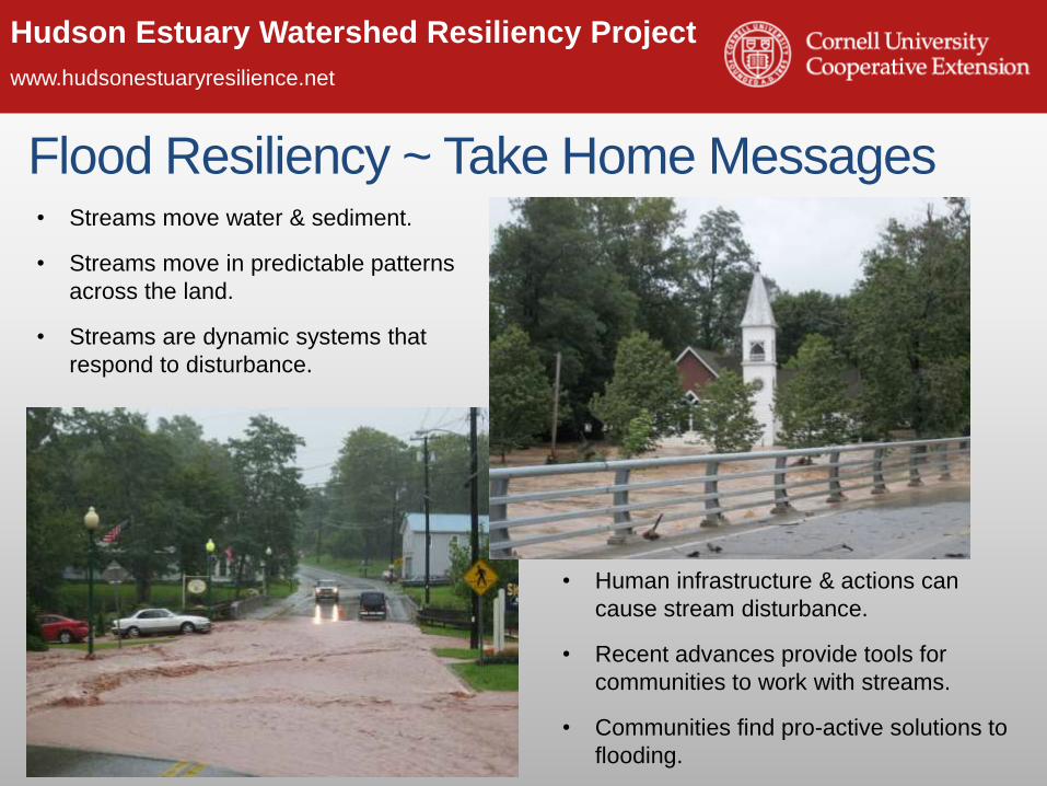
Hudson Estuary Watershed Resiliency Project
www.hudsonestuaryresilience.netBuilding Long-term Resilience to Extreme Weather and Climate Change in the
Hudson Estuary Watershed
A program of Cornell Cooperative Extension in partnership with the NYS DEC Hudson River Estuary Program, NY Water Resources Institute and Cornell University with support from the NYS Environmental
Protection Fund.
Streams 101: Stream Basics & Planning
for Flood Resiliency
Hudson Estuary Watershed Resiliency Project
www.hudsonestuaryresilience.net
An initiative of Cornell Cooperative Extension of
Columbia-Greene, Dutchess and Orange Counties in
partnership with the NYS DEC Hudson River Estuary
Program, NY Water Resources Institute and Cornell
University with support from the NYS Environmental
Protection Fund.
Hudson Estuary Watershed
Resiliency Project
Hudson Estuary Watershed Resiliency Project
www.hudsonestuaryresilience.net
Hudson Estuary
Hudson Estuary Watershed Resiliency Project
www.hudsonestuaryresilience.net
4
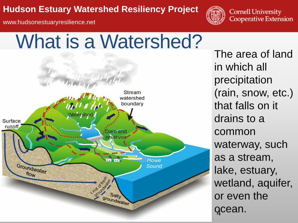
The area of land
in which all
precipitation
(rain, snow, etc.)
that falls on it
drains to a
common
waterway, such
as a stream,
lake, estuary,
wetland, aquifer,
or even the
ocean.
What is a Watershed?
Hudson Estuary Watershed Resiliency Project
www.hudsonestuaryresilience.net
Hudson Watershed
• Hudson River watershed is 13,390 square miles in size.
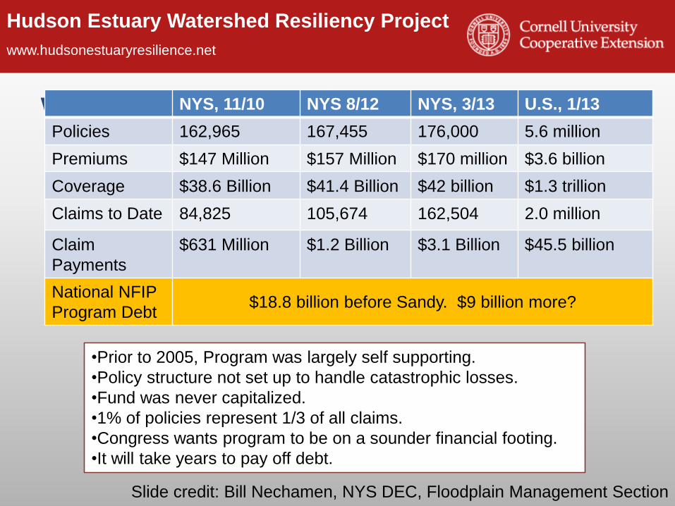
$631 Million $1.2 Billion $3.1 Billion $45.5 billion
National NFIP
Program Debt$18.8 billion before Sandy. $9 billion more?
•Prior to 2005, Program was largely self supporting.
•Policy structure not set up to handle catastrophic losses.
•Fund was never capitalized.
•1% of policies represent 1/3 of all claims.
•Congress wants program to be on a sounder financial footing.
•It will take years to pay off debt.
Slide credit: Bill Nechamen, NYS DEC, Floodplain Management Section
Hudson Estuary Watershed Resiliency Project
www.hudsonestuaryresilience.net
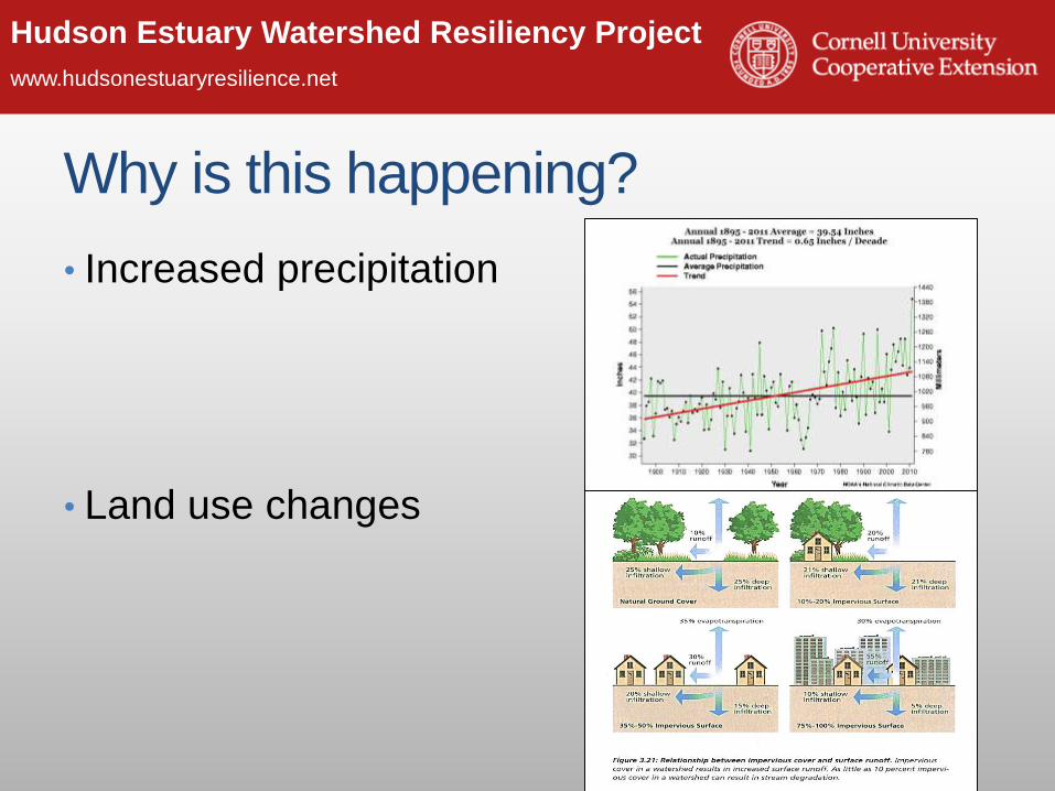
Why is this happening?
• Increased precipitation
• Land use changes
Hudson Estuary Watershed Resiliency Project
www.hudsonestuaryresilience.net
Our climate is changing
Temperature changes from 1991-2012 compared to the 1901-1960 average (and compared to the 1951-1980 average for Alaska and Hawai‘i). NOAA NCDC / CICS-NC
Hudson Estuary Watershed Resiliency Project
www.hudsonestuaryresilience.net
Era of Extreme Weather
The map shows percent
increases in the amount
of precipitation falling in
very heavy precipitation
events (defined as the
heaviest 1% of all daily
events) from 1958 to
2011 for each region. Source: National Climate Assessment,
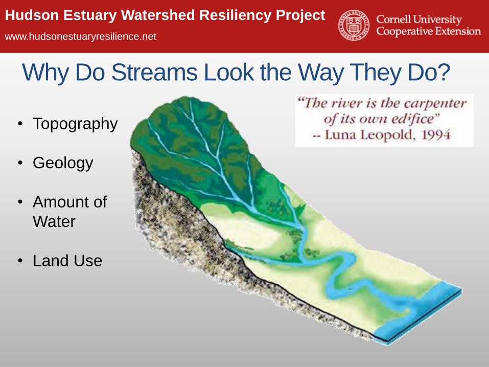
Flowing Water Moves Sediment• As water moves over the land it picks up sediment, forming the stream channel
• Streams create and maintain their shape and size themselves, a result of:• Volume of water
• Amount of sediment
• Type of sediment
Hudson Estuary Watershed Resiliency Project
www.hudsonestuaryresilience.net
Streams Flow in Predictable Patterns
Hudson Estuary Watershed Resiliency Project
www.hudsonestuaryresilience.net
Upland Stream Type: Step - Pool
Adapted from Applied River Morphology, Dave Rosgen, 1996
Dissipating Energy Naturally
Hudson Estuary Watershed Resiliency Project
www.hudsonestuaryresilience.net
Deposition on the inside
of meander bend.
Erosion on outside
of meander bend.
Lowland Stream Type: Riffle – Pool & Meander Bends
Meander Bends are a natural way streams
slow the movement of
water or dissipate energy
in flat areas.
Riffle
Pool
Hudson Estuary Watershed Resiliency Project
www.hudsonestuaryresilience.net
Balancing Act• Streams are said to be in equilibrium or
balance when the volume of water is enough to transport the available sediment without building up the channel (deposition) or cutting down the channel (erosion).
Hudson Estuary Watershed Resiliency Project
www.hudsonestuaryresilience.net
Streams will Respond to Disturbances that
Create Instability
Unstable Streams will Evolve to Return to a Balanced State
Human Caused
OR
Natural
Hudson Estuary Watershed Resiliency Project
www.hudsonestuaryresilience.net
Stream Channel EvolutionUpland - limited floodplain Lowland with floodplain
Hudson Estuary Watershed Resiliency Project
www.hudsonestuaryresilience.net
Further impacting our streams (aka
making flooding worse)
• Why are we here?
• Causes of increased flooding in our
municipalities
• A closer look at what is happening in our
streams
• How we are impacting streams (and
making flooding worse)
• Solutions and Resources
Hudson Estuary Watershed Resiliency Project
www.hudsonestuaryresilience.net
Human Impacts on Streams – Flood Response
Flood Response May Cause Stream Instability
Dredging
Berms
Channel
Straightening
Tree Removal
Hudson Estuary Watershed Resiliency Project
www.hudsonestuaryresilience.netDoes Dredging help flooding?
Hudson Estuary Watershed Resiliency Project
www.hudsonestuaryresilience.net
Hudson Estuary Watershed Resiliency Project
www.hudsonestuaryresilience.net
Berms
Hudson Estuary Watershed Resiliency Project
www.hudsonestuaryresilience.net
Channel Straightening
48
Shorter distance means a
steeper slope
A steeper slope increases
velocity
A steeper slope increases
erosion on the streambank
and bed
400’ Straightened
Channel
500’ Meandered
Channel
Hudson Estuary Watershed Resiliency Project
www.hudsonestuaryresilience.net
Hudson Estuary Watershed Resiliency Project
www.hudsonestuaryresilience.net
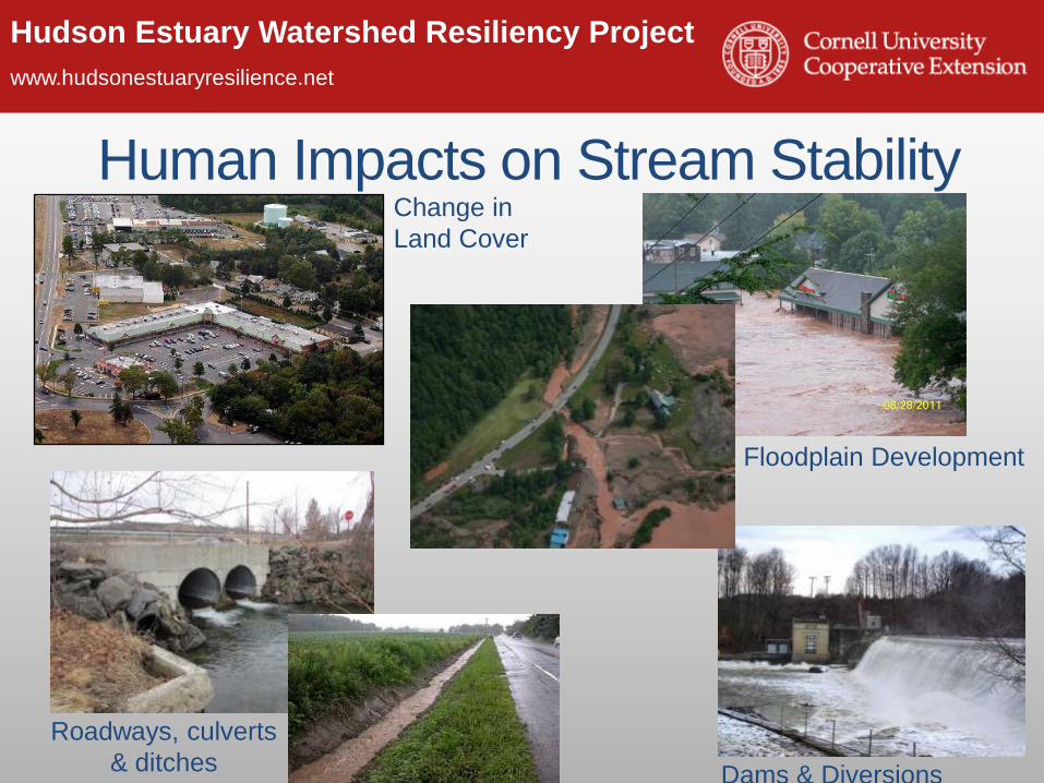
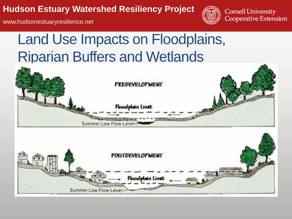
Human Impacts on Stream Stability
Roadways, culverts
& ditchesChange in Land Cover
Dams & Diversions
Floodplain Development
What Can We Do?!!!
Hudson Estuary Watershed Resiliency Project
www.hudsonestuaryresilience.net
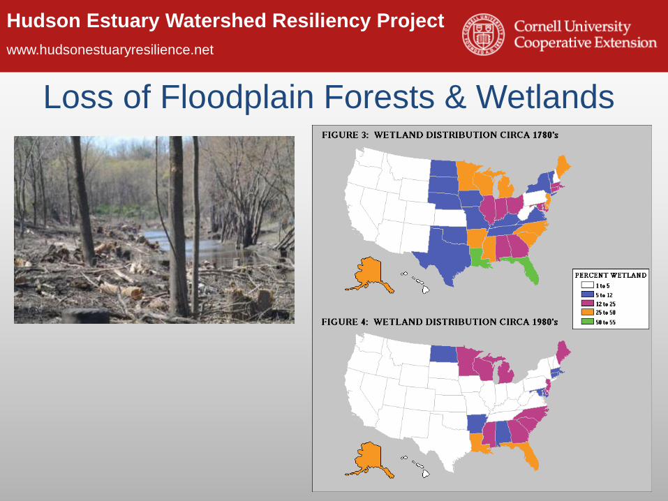
Solutions & Resources:• Local wetland and riparian buffer
ordinances.
• Stream Corridor Protection
Greenway Guide
• NYS DEC Trees for Tribs plantings
to restore riparian buffers.
• Encourage forest and wetland
stewardship by property owners.
Conservation
Hudson Estuary Watershed Resiliency Project
www.hudsonestuaryresilience.net
Smart Growth / Better Site Design / Low
Impact Development
“Narrow streets with short setbacks … are safer …
use less land, reduce stormwater runoff and cut
construction and maintenance costs…”
Hudson Estuary Watershed Resiliency Project
www.hudsonestuaryresilience.net
green roofs bio-infiltration swalesGreen
Infrastructure
rain garden
porous pavement
Slide credit: Dr. Allison Roy
Solutions & Resources:• Zoning techniques to minimize
impervious cover
• Green Infrastructure Greenway
Guide.
• Encourage forest and wetland
stewardship by property owners.
Hudson Estuary Watershed Resiliency Project
www.hudsonestuaryresilience.net
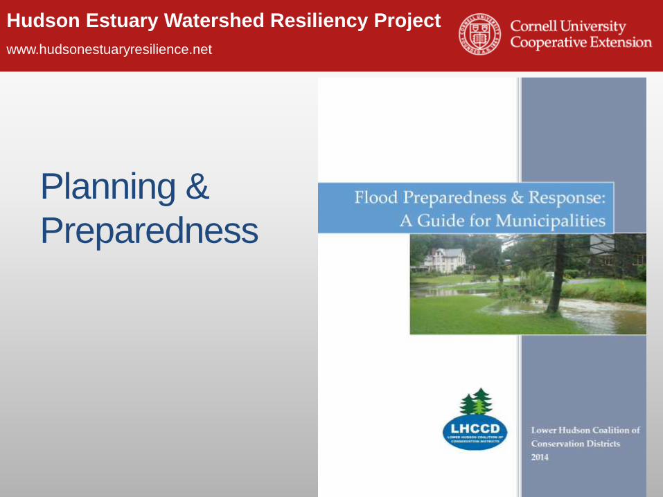
Planning &
Preparedness
Hudson Estuary Watershed Resiliency Project
www.hudsonestuaryresilience.net
Reconsider Land Use Within Floodplains
Solutions & Resources:• Zoning Codes and Overlay
Districts
• Pace Land Use Law Center
Gaining Ground database
• Flooding and Land Use Planning:
A Guidance Document for
Municipal Officials and Planners
Hudson Estuary Watershed Resiliency Project
www.hudsonestuaryresilience.net
Take Stock of Your InfrastructureBridgesCulverts
Roadside Ditching
Solutions & Resources:• Culvert sizing initiative in the Hudson Valley
• Research & Outreach on Roadside Ditches & Flooding
• Innovations on bridge construction for flood resiliency piloted in
Delaware County
• Post Flood Stream Intervention Training for Highway Personnel