Streetcar Expansion Policy Project Streetcar Expansion Policy Brief 10 November 2010 Prepared by: Katie Discher Olia Friedrichs Natalie Masone This report was written by undergraduate students at Loyola University New Orleans under the direction of Dr. Peter F. Burns.
Transcript
Streetcar Expansion Policy Project
Streetcar Expansion Policy Brief
10 November 2010
Prepared by:
Katie Discher
Olia Friedrichs
Natalie Masone
This report was written by undergraduate students at Loyola University New
Orleans under the direction of Dr. Peter F. Burns.
Table of Contents EXECUTIVE SUMMARY 1
INTRODUCTION 2
I. NEW ORLEANS STREETCAR SYSTEM 3
II. STANDARD RESEARCH AND METHODOLOGY 4
III. APPLICATION CITIES 5
3.1 Tucson, Arizona 6
3.2 Tampa, Florida 8
3.3 Atlanta, Georgia 8
IV. NEW ORLEANS, LOUISIANA (HISTORY): 10
V. NEW ORLEANS, LOUISIANA (ACTUAL): 10
5.1 DISADVANTAGED AREAS 10
5.2 STREETCAR 10
5.3 EVACUATION 11
VI. POLICY RECOMMENDATIONS 12
6.1 DISADVANTAGED AREAS & STREETCAR 12
6.2 EVACUATION 13
VII. APPENDIX 15
1
EXECUTIVE SUMMARY
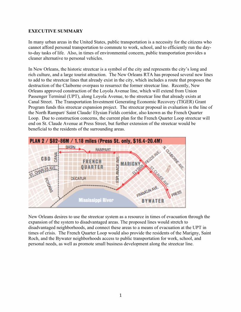
In many urban areas in the United States, public transportation is a necessity for the citizens who cannot afford personal transportation to commute to work, school, and to efficiently run the day-to-day tasks of life. Also, in times of environmental concern, public transportation provides a cleaner alternative to personal vehicles. In New Orleans, the historic streetcar is a symbol of the city and represents the city’s long and rich culture, and a large tourist attraction. The New Orleans RTA has proposed several new lines to add to the streetcar lines that already exist in the city, which includes a route that proposes the destruction of the Claiborne overpass to resurrect the former streetcar line. Recently, New Orleans approved construction of the Loyola Avenue line, which will extend from Union Passenger Terminal (UPT), along Loyola Avenue, to the streetcar line that already exists at Canal Street. The Transportation Investment Generating Economic Recovery (TIGER) Grant Program funds this streetcar expansion project. The streetcar proposal in evaluation is the line of the North Rampart/ Saint Claude/ Elysian Fields corridor, also known as the French Quarter Loop. Due to construction concerns, the current plan for the French Quarter Loop streetcar will end on St. Claude Avenue at Press Street, but further extension of the streetcar would be beneficial to the residents of the surrounding areas.
New Orleans desires to use the streetcar system as a resource in times of evacuation through the expansion of the system to disadvantaged areas. The proposed lines would stretch to disadvantaged neighborhoods, and connect these areas to a means of evacuation at the UPT in times of crisis. The French Quarter Loop would also provide the residents of the Marigny, Saint Roch, and the Bywater neighborhoods access to public transportation for work, school, and personal needs, as well as promote small business development along the streetcar line.
2
INRODUCTION
When compared to cities of a similar size, New Orleans’s public transportation system is inefficient and inadequate, because of the limited access to the light rail transportation system. Many residents of New Orleans see the historical streetcar as a tourist attraction, but a great number of New Orleanians use the streetcar as transportation for their everyday lives. Currently, 14% of New Orleans residents use public transportation as their means to commute, but the issue is that the streetcar lines do not stretch to the areas where public transportation is a need the most. With little access to public transportation, 32% of the households in the Lower Ninth Ward do not have access to a personal vehicle, while 27% of the households in the entire city do not own a car.i The limited system hinders the residents of New Orleans, those of the Lower Ninth Ward in particular, and an expanded system would better New Orleans citizens with a greater access to all opportunities of the city.
3
I. NEW ORLEANS STREETCAR SYSTEM
The New Orleans streetcar system has been in service since 1835, and is only one of three light rail systems that still operates on pre-1970 technology. The New Orleans streetcar system today covers approximately 13 miles along the three active routes. In the 1920’s, the streetcar tracks totaled 235 miles, which crisscrossed the city. Table 1.1: House Value by Neighborhood
Today, the Saint Charles Route provides access to University students at Loyola and Tulane, as well as access to Audubon Park, and the Central Business District. These areas of New Orleans, as seen in the map, are the highest valued areas in the city.
4
II. STANDARD RESEARCH AND METHODOLOGY
Transport for NOLA is an organization, which consists of advocates of enhancement to the current light rail system in place in New Orleans today to better the neighborhoods of the city, and provide opportunities thorough the public service. Research shows that 28% of New Orleanians do not own automobiles, or have some means of personal transportation, without some sort of fixed public transportation system. Research shows that with every dollar invested in public transportation, six dollars in economic activity is generated. Financially, the light rail system has the lowest cost per passenger mile compared to any other form of transportation. Also, development of businesses and property values increase along transit lines. Construction of public transportation systems also provides jobs for unemployed workers. Environmental benefits of a public transit system include greater fuel and energy efficiency, as well as reduction of greenhouse emissions. With the provision of opportunities to those without personal transportation comes community development increases. Public transportation offers possible evacuation resources to citizens. The ideal circumstance is that in times of evacuation, public transportation will efficiently transport residence to designated areas where they will be able to evacuate the city properly. With these improvements to the city of New Orleans, the image of the city will improve to it’s residents, and tourists. With the streetcar as an iconic symbol of New Orleans as a city and the expansion of the image all over the city, the image of the city will make progress.ii
5
III. APPLICATION CITIES The New Orleans streetcar system began in 1893. The St. Charles line is included in the world’s oldest electric railway line, which operates continuously. The line was the only survivor in the 1964 conversions from light rail streetcars to bus systems. However, in the 1990’s streetcars were reintroduced into the city. The streetcar is back in many U.S. cities today. Most of today’s streetcars are modern streetcars. This simply refers to the style of the transit. Both are still forms of light rail transportation that provide cities with a sustainable way of travel. Comparative Table of Application Cities
City: New Orleans, LA
Tucson, AZ Tampa, FL Atlanta, GA
Completion Time:
N/A 2012 Spring 2012 Winter 2010 N/A 2013
Currently in Operation:
Yes Yes Yes No
Project Length:
1.18 miles 3.9 miles 2.3 miles 27 miles
Major Destinations Served:
The Marigny, Saint Roch, and the Bywater neighborhoods, The French Quarter, Loyola Avenue corridor
The Arizona Health Sciences Center, the University of Arizona main campus, the Main Gate retail/entertainment area, the 4th Avenue retail/entertainment area, Downtown Tucson, the West End planned development, the El Rio Community Health Center and the Tucson Empowerment Zone.
Connect downtown with the Ybor City and Channelside Drive entertainment areas; adding 4 stations in disadvantaged neighborhoods
Key Atlanta attractions venues including Philips Arena, the Georgia Dome, the Georgia World Congress Center, CNN Center, the Georgia Aquarium, World of Coca-‐Cola Museum, and future National Center for Civil and Human Rights (under development
6
3.1 Tucson, Arizona The city of Tucson, Arizona has recognized the light rail streetcar system as an effective transportation method. With the Tucson, Arizona department of transportation has proposed the addition of a 3.9-mile modern streetcar to the primary activity centers of the city. The United Streetcar/Oregon Ironworks will manufacture the streetcar. It will be the first in the U.S. in the past 58 years. Operation of this system is projected to begin in the spring of 2012. The city has projected that many benefits will result from the addition of the modern streetcar to Tucson.
*(YOE $) Year of Expenditure ** (Source: Tucson, AZ TIGER Grant) First, the addition of this system will improve transit system, which already exists. The system will aid to the mission of the Tucson transportation system, which is to provide a seamless mass transit system. Tucson currently has an award winning bus system, Sun Tran. These routes will be routed and work in conjunction with the modern streetcar. However, passengers on the streetcar will save 13 minutes of their commute time on the streetcar opposed to the Sun Tran Bus. iii In addition, the modern streetcar will provide a newfound economic competitiveness. It will provide citizens opportunities to invest and increase the property value of the area, which surrounds the streetcar route. According to the information in the TIGER Grant, estimates have been made that property value will increase to $35 million by 2015. Also, long-term employment will be a direct benefit. An estimated 1,480 long-term jobs will be created as a result according to studies. iv
7
Next, the residents of Tucson will experience better quality of life due to the increased mobility and improved accessibility. The increase in the mobility will be largely due to the fact that the streetcar will be equipped to handle the capacity of about 130-150 opposed to the Sun Tran bus’ 80-100 capacity.
(Source: Tucson, AZ TIGER Grant) Improved accessibility to popular destinations will be an advantage to both low-income neighborhoods and those that host senior citizens. Currently, 10% of the population is within walking distance of the projected modern streetcar route. This is a key factor since about one-third of the poverty level is located in the corridor. Additionally, the modern streetcar will serve, as an economically responsible alternative due to the fact it will reduce travel cost be about 40%. v To continue on the economics of the project, the 20 year present value is estimate at $166 million. Tucson has been awarded the TIGER Grant, which will provide $73 million to the project. Local funding will also be provided to assist in the creation of this modern streetcar a reality for the city Tucson, Arizona.
(Source: Tucson, AZ TIGER Grant)
8
3.2 Tampa, Florida In Tampa, Florida streetcar lines (TECO) were an essential mode of transportation in the early days of transit. First built in 1892, the peak of their popularity did not come until many years later during the 1920’s. However, after World War II in August 1946, the system came to a sudden end. New technologies are largely responsible for the decision to stop the operation of the streetcar. In 2002, the streetcar made its comeback in Tampa. The 2.4-mile line was reopened through an endowment by the city. The system has eleven cars in operation as of today. Currently, this system serves as phase one of the multi-phase projects. The newest phase is currently under construction and will extend one-third of a mile to connect downtown workers to major city sites.vi It, like the previous projects, will be funded by both state and federal money. This will serve as phase-two of TECO, Tampa streetcars, extension and comeback as a major method of transportation throughout the city and nearby areas.vii The extension has direct benefits to citizens both uptown and downtown Tampa. It will provide a direct route to Tampa’s downtown opposed to the nearby one that Tampa currently uses today. Already, merchants have created economic stimulus in the downtown area. 3.3 Atlanta, Georgia Like the previous cities, Atlanta Georgia also has plans to add a streetcar to their metropolitan transit system. The addition of a streetcar in Georgia will be the first in 60 years called the Georgia Transit Connector. The streetcar will extend its benefits beyond strictly the Atlanta area. The project will have benefits on both a regional and national scale. It will provide Atlanta with a newfound connectivity of the downtown area. An improvement of accessibility will make travel to major cites more convenient than ever. The streetcar is designed to accommodate a large majority of commuters from senior citizens to college students. The location of the Atlanta streetcar will serve as a benefit to economically distressed areas of concern. The project is set out to serve as a change agent to introduce a new pedestrian environment to distressed areas that already exist. The streetcar will influence zoning plans for impoverished neighborhoods for future change to these areas. The streetcar will consist of a 27-mile track, which includes twelve stations and four vehicles. Georgia’s plan is unique compared to other streetcar models because of the design to incorporate the MARTA rail service that already exists. Additionally, the following characteristics are part of the proposed streetcar, a 9.9-minute one-way run time with a 15-minute frequency. viii The fact that the streetcar will run through the most populated commercial area in the city is no coincidence. The purpose is to provide citizens, tourist, and businesses a mode of transportation that meets urban needs. Atlanta has recognized the transit- dependent neighborhoods throughout the city and will use the streetcar as a means to circulate and encourage economic growth in economically distressed areas of Atlanta. The economics of this project reflects others; it will both increase property value and create jobs. This new transportation route will restore many parts of Atlanta, which have been neglected, thus an emphasis will be put on sustainable growth.
9
Three major partnerships have helped make this possible for Atlanta; Metropolitan Atlanta Rapid Transit Authority (MARTA), Atlanta Downtown Improvement District, and the City of Atlanta. First year operation and maintenance cost are estimated at $1.714 million. The total projected cost for the project amounts to an average of $72.158 million. Completion is projected for the year 2013.ix Comparative Table of Application Cities Funding: Location:
New Orleans, LA Tucson, AZ Tampa, FL Atlanta, GA
Sponsor:
Regional Transportation Authority
City of Tucson
Hillsborough Area Regional Transit (HARTline)
City of Atlanta
Total Cost:
$45,000,000
$150,100,000
$2,400,000
$72,157,897
TIGER Funding:
$45,000,000
$63,000,000
N/A
$56,158,000
Other Funding: N/A
Voter Approved Local Funding
TECOLine Streetcar System Endowment
City of Atlanta, Atlanta Downtown Improvement District
10
IV. NEW ORLEANS, LOUISIANA (HISTORY)
STREETCAR The streetcar system underwent a difficult setback after Hurricane Katrina. The water flooded the cars and debris took down several of the line’s electrical lines. Only the old model streetcars survived because they had been stored in a separate warehouse on higher ground. The electrical system had been fried and it took several months to restart the system. It cost one million dollars to repair each individual streetcar. x V. NEW ORLEANS, LOUISIANA (CURRENTLY) 5.1 DISADVANTAGED AREAS Since Hurricane Katrina, certain areas of the city of New Orleans have been deprived the public amenities which they deserve. The Lower Ninth Ward is especially underserved based on its low housing values and lack of public transportation. 12% of the United States’ population currently lives below the poverty level. New Orleans’ average is even worse at 28% with the Lower Ninth Ward even higher at 36%. Part of the problem with the high poverty level of the Lower Ninth Ward in New Orleans lies in the fact that this area of the city’s unemployment rate is also extremely high. The Lower Ninth Ward’s unemployed civilian labor force stands at 14% compared to the National average of 6%.xi 5.2 STREETCAR A lack of vehicle availability to individuals leads to the problems that disadvantaged areas face. In particular, 32% of the Lower Ninth Ward has no access to vehicles. Only 10% of the United State’s average citizens are currently without access to vehicles.xii However, public transportation is a viable alternative as a means of transportation for citizens to travel to and from jobs. The Regional Transit Authority’s goal is to fulfill the mobility needs of the New Orleans’ public community.xiii Currently, the streetcar system consists of three lines: the Canal Street line, the St. Charles line, and Riverfront line. The three lines originate downtown and disperse to various parts of the city for a flat rate of $1.25.xiv As of February of 2010, the U.S. Department of Transportation awarded a $45 million grant to the RTA for the construction of additional streetcar lines.xv The Transportation Investment Generating Economic Recovery, or TIGER, grant awarded the New Orleans Streetcar Project with the eleventh largest grant. The TIGER grant will cover the entire costs of the project, which is planned to be complete by 2012.xvi The Streetcar Expansion Project will help to improve access to employment as well as entertainment to recovery areas of the city in order to boost economic redevelopment post-Katrina.xvii
11
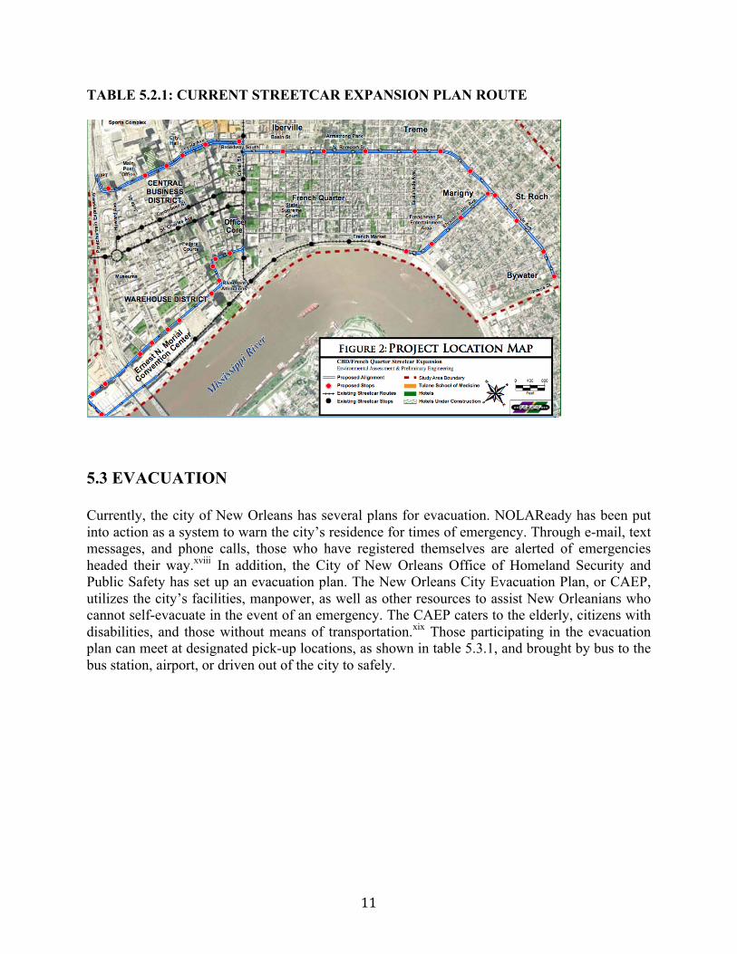
TABLE 5.2.1: CURRENT STREETCAR EXPANSION PLAN ROUTE
5.3 EVACUATION Currently, the city of New Orleans has several plans for evacuation. NOLAReady has been put into action as a system to warn the city’s residence for times of emergency. Through e-mail, text messages, and phone calls, those who have registered themselves are alerted of emergencies headed their way.xviii In addition, the City of New Orleans Office of Homeland Security and Public Safety has set up an evacuation plan. The New Orleans City Evacuation Plan, or CAEP, utilizes the city’s facilities, manpower, as well as other resources to assist New Orleanians who cannot self-evacuate in the event of an emergency. The CAEP caters to the elderly, citizens with disabilities, and those without means of transportation.xix Those participating in the evacuation plan can meet at designated pick-up locations, as shown in table 5.3.1, and brought by bus to the bus station, airport, or driven out of the city to safely.
12
TABLE 5.3.1: EVACUATION PICK-UP BY BUS LOCATIONS
VI. POLICY RECOMMENDATIONS 6.1 DISADVANTAGED AREAS & STREETCAR The current streetcar project plans to run lines through the Central Business District. The proposed lines will cover an area of the Superdome in order to increase business as well as tourism. The project is also meant to add additional transportation for citizens of New Orleans to work. However, as the future routes stand, the lines along St. Claude Avenue extend only as far as Press Street, potentially due to the railroad tracks that run along Press Street. Based on our research, it would be most beneficial if the line were extended as far as Poland Avenue, as shown in table 6.1.1. If this extension of the streetcar line were built, it would connect the Lower Ninth Ward with the rest of the city and provide transportation. A streetcar in this area would provide residents with access to necessities such as fresh food and encourage small business growth and bring people to green space along the river. Also, it would allow them a way in and out of the city for work via public transportation, which would in effect, decrease unemployment and poverty rates. Over the past five years, the percentage of New Orleanians who take public transit to work has been on the decline. In 2005, 12.2% of workers used public transit for work, but that number has declined to 7.3%. Conversely, the national has been on the rise, as shown in table 6.2. The
13
percentile in the city of New Orleans would likely begin to rise again if public transit was redirected to the correct demographic.xx TABLE 6.1.1: RECOMMENDED ADDITION TO STREETCAR EXPANSION PLAN ROUTE
TABLE 6.1.2: STATISTIC ON USE OF PUBLIC TRANSIT
6.2 EVACUATION Our proposed streetcar line would help to evacuate residence, especially those involved in the CAEP plan. When it comes to times of extreme weather, the lines may go down, but if they were used ahead of time they would be highly efficient. The CAEP has several bus stops throughout
14
the city as pick up locations for citizens in need of evacuation help. Streetcars could be used instead of busses to pick people up and take them to the Union Passenger Terminal, New Orleans’ main train station to leave the city from there. Also, if busses were freed up from making city loops, they could be better used as methods for residents to leave the city.
15
VII. APPENDIX i “Three Paths to a Lower Car City.” Human Transit. Web. 14 Dec. 2010. <http://www.humantransit.org/2010/01/three-‐kinds-‐of-‐lowcar-‐city.html>. ii Transport for NOLA. Web. 8 Nov. 2010. <http://www.transportfornola.org/>. iii Tucson Department of Transportation. "Tucson, AZ Tiger Grant." City of Tucson: Department of Transportation. Web. 10 Nov. 2010. <http://dot.tucsonaz.gov/>. iv Tucson Department of Transportation. "Tucson, AZ Tiger Grant." City of Tucson: Department of Transportation. Web. 10 Nov. 2010. <http://dot.tucsonaz.gov/>. v Tucson Department of Transportation. "Tucson, AZ Tiger Grant." City of Tucson: Department of Transportation. Web. 10 Nov. 2010. <http://dot.tucsonaz.gov/>. vi "Streetcars Return to Tampa." Light Rail Now Light Rail Transit (LRT), Trams, Tramways, Streetcars, Rail Transit. Web. 10 Nov. 2010. <http://www.lightrailnow.org/news/n_tam001.htm>. vii "Tiger Grant II / About TPA." Home - Tampa Port Authority. 2009. Web. 10 Nov. 2010. <http://www.tampaport.com/About-TPA/Tiger-Grant-II>. viii "Whiting Street Extension Project." TECO Line Steetcar System. 12 Oct. 2010. Web. 10 Nov. 2010. <http://tecolinestreetcar.org/extension/index.htm>. ix "Streetcar Comeback." Central Atlanta Progress | Atlanta Downtown Improvement District. Web. 10 Nov. 2010. <http://www.atlantadowntown.com/>. x Rahim, Saqib. "The Desire for Streetcars Returns." Online posting. Earth News. Environmental Information Coalition, 1 Aug. 2008. Web. 6 Nov. 2010. <http://www.earthportal.org/news/?p=1473>. xi Wagner, Peter. "The Economy in Numbers: New Orleans by the Numbers." Dollars and Sense Mar.-Apr. 2006. Web. 5 Nov. 2010. <http://www.dollarsandsense.org/archives/2006/0306wagneredwards.html>. xii Regional Transit Authority : RTA News. 2002-2010. Web. 08 Nov. 2010. <http://www.norta.com/>. xiii "Getting Around: New Orleans Streetcar." The Official Tourism Site of the City of New Orleans. 1996-2010. Web. 8 Nov. 2010. <http://www.neworleansonline.com/tools/transportation/gettingaround/streetcars.html>.
16
xiv "New Orleans Central Business District/French Quarter Streetcar Expansion." Regional Transit Authority : RTA News. Environmental Assessment and Preliminary Engineering, Dec. 2009. Web. 09 Nov. 2010. <http://www.norta.com/>. xv "New Orleans: 5 Years After Katrina | Housing | Rebuilding." GCR & Associates, Inc. Web. 09 Nov. 2010. <http://www.gcrconsulting.com/katrina5year/housing.html>. xvi "Feds Award City $45M for Loyola Streetcar Loop." New Orleans CityBusiness. CityBusiness Staff Reports, 17 Feb. 2010. Web. 05 Nov. 2010. <http://neworleanscitybusiness.com/blog/2010/02/17/feds-award-city-45m-for-loyola-streetcar-loop/>. xvii "NOLAReady New Orleans Community Alert System." NOLAReady. Cooper Notification. Web. 26 Oct. 2010. <https://www.nolaready.info/register.php>. xviii Nagin, C. Ray. A Guide to Accessing the CAEP. New Orleans: One New Orleans. Print. xix "The New Orleans City Assisted Evacuation Plan." 1 800 CityInfo.com. Web. 09 Nov. 2010. <http://1-800-cityinfo.com/>. xx "New Orleans: 5 Years After Katrina | Housing | Rebuilding." GCR & Associates, Inc. Web. 09 Nov. 2010. <http://www.gcrconsulting.com/katrina5year/housing.html>.