120
HAMILTON SENIOR HIGH SCHOOL REDEVELOPMENT NOVEMBER 2019 LOCAL STRUCTURE PLAN

HAMILTON SENIOR HIGH SCHOOL REDEVELOPMENT
NOVEMBER 2019
LOCAL STRUCTURE PLAN

ii
CONTACTNaden Scarfone - Urban Planner
E [email protected] +61 8 9381 0200 F +61 8 9382 4224
Level 2, 50 Subiaco Square Road Subiaco WA 6008
Project Ref. 43711
Prepared for:
Revision Letter Date Reason for Issue CM
A 25-08-2017 Draft HLSP for Client Review MS
B 12-09-2017 Draft HLSP for Client Review MS
C 20-12-2017 Final Draft for Client Review MS
D 02-02-2018 Final Draft for Lodgement MS
E 10-05-2018 Final Draft for Lodgement NS
F 12-06-2018 Final Draft for Lodgement NS
G 22-06-2018 Final Draft for Lodgement - Environmental Updates NS
H 11-11-2019 Final - WAPC Modifications NS
I 28-11-2019 Final - WAPC Modifications (Minor Amendments) NS
DISCLAIMER
The information contained in this report has been prepared with care by our company, or it has been supplied to us by apparently reliable sources. In either case, we have no reason to doubt its completeness or accuracy. However, neither this company nor its employees guarantee the information, nor does it or is it intended to form part of any contract. Accordingly, all interested parties should make their own inquiries to verify the information, as well as any additional or supporting information supplied, and it is the responsibility of interested parties to satisfy themselves in all respects.
This report is for the use only of the party to whom it is addressed and Hames Sharley disclaims responsibility to any third party acting upon or using the whole or part of its contents.
This document has been prepared for the use of the LandCorp only. Copyright © 2019 by Hames Sharley WA Pty Ltd. No part of this document shall be reproduced in any form without written permission of Hames Sharley.
Prepared by Hames Sharley:
In collaboration with Josh Byrne and Associates, Tabec, Transcore, PGV Environmental and Strategen Environmental.

CONTENTSPART ONE IMPLEMENTATION 10
1.0 LOCAL STRUCTURE PLAN IMPLEMENTATION 12
PART TWO EXPLANATORY SECTION 18
2.0 INTRODUCTION & PURPOSE 21
3.0 CONTEXT ANALYSIS 35
4.0 SITE ANALYSIS 51
5.0 CONCEPT DESIGN 67
6.0 THE STRUCTURE PLAN 75
PART THREE TECHNICAL APPENDICES 104A) Engineering Infrastructure Report
B) Geotechnical Investigations
C) Transport Impact Assessment
D) Transportation Noise Assessment
E) Flora and Fauna Survey
F) Landscape Master Plan
G) Local Water Management Strategy
H) Sustainability Strategy Report
I) Energy Strategy Report
J) Water Strategy Report
K) Aboriginal Engagement Strategy
L) Aboriginal Heritage Survey
M) Bushfire Management Plan
iii
LIST OF FIGURESFIGURE 1: STRUCTURE PLAN MAP 13
FIGURE 2: STRUCTURE PLAN STAGING 17
FIGURE 3: HLSP ENVIRODEVELOPMENT 23
FIGURE 4: HLSP AREA 26
FIGURE 5: TPS3 ZONING 27
FIGURE 6: REGIONAL CONTEXT 37
FIGURE 7: WALKABILITY AND AMENITY 38
FIGURE 8: PUBLIC TRANSPORT 39
FIGURE 9: ACTIVE TRANSPORT 40
FIGURE 10: VEHICLE TRANSPORT 41
FIGURE 11: OPEN SPACE 42
FIGURE 12: STUDY AREA 43
FIGURE 13: HAMILTON HILL HOUSE SALES AND VOLUME 48
FIGURE 14: HAMILTON HILL UNIT SALES AND VOLUME 49
FIGURE 15: HAMILTON HILL LAND SALES AND VOLUME 49
FIGURE 16: SITE PLAN 53
FIGURE 17: MICROCLIMATE AND ENVIRONMENT 57
FIGURE 18: TOPOGRAPHY - SURFACE ELEVATIONS 58
FIGURE 19: TOPOGRAPHY - SURFACE SLOPES 59
FIGURE 20: EXISTING LANDSCAPE CONDITIONS 61
FIGURE 21: SERVICING CAPACITY 63
FIGURE 22: OPPORTUNITIES 64
FIGURE 23: CHALLENGES 65
FIGURE 24: CONCEPT PLAN 77
FIGURE 25: SECTIONS 78
FIGURE 26: PROPOSED PARKING PLAN 85
FIGURE 27: PUBLIC OPEN SPACE DISTRIBUTION 89
FIGURE 28: LANDSCAPE MASTER PLAN 92
FIGURE 29: PROPOSED TREES PLAN 94
FIGURE 30: WSUD INFRASTRUCTURE PLAN 95
FIGURE 31: HSHS BAL CONTOUR MAP 100
FIGURE 32: TREE PROTECTION 101
FIGURE 34: NOISE WALL OPENING 103
FIGURE 33: NOISE WALL EXTENT 103
iv

LIST OF ABBREVIATIONSABS Australian Bureau of StatisticsAHD Australian Height DatumBAL Bushfire Attack LevelBMP Bushfire Management PlanCBD Central Business DistrictCBEH Centre for Built Environment and HealthCPTED Crime Prevention Through Environmental DesignDFES Department of Fire and Emergency ServicesDWER Department of Water and Environmental RegulationDOP Department of Planning (WA)HSHS Hamilton Senior High SchoolHLSP Hamilton Senior High School Local Structure PlanLWMS Local Water Management StrategyLPS City of Cockburn Local Planning StrategyMRS Metropolitan Region SchemeMRWA Main Roads Western AustraliaPAW Public Access WayPBN Perth Bicycle NetworkPOS Public Open SpaceSMC Strategic Metropolitan CentreSPP State Planning PolicyTPS3 City of Cockburn Town Planning Scheme No.3UDIA Urban Development Institute of AustraliaVPD Vehicles Per DayWAPC Western Australian Planning CommissionWSUD Water Sensitive Urban Design
LIST OF TABLESTABLE 1: PRE-LODGEMENT ENGAGEMENT SUMMARY 31
TABLE 2: AGE PROFILE COMPARISON 44
TABLE 3: FAMILY COMPOSITION COMPARISON 44
TABLE 4: HOUSEHOLD TYPES 45
TABLE 5: INCOME COMPARISON 45
TABLE 6: LABOUR FORCE PARTICIPATION COMPARISON 45
TABLE 7: COUNTRY OF BIRTH 45
TABLE 8: SOCIAL TRANSITION IN HAMILTON HILL 46
TABLE 9: YIELD ANALYSIS 76
TABLE 10: PUBLIC OPEN SPACE SCHEDULE 88
v

VI
ENDORSEMENT PAGEThis Structure Plan is prepared under the provisions of the City of Cockburn Town Planning Scheme No. 3.
IT IS CERTIFIED THAT THIS ACTIVITY CENTRE PLAN WAS APPROVED BY RESOLUTION OF THE WESTERNAUSTRALIAN PLANNING COMMISSION ON:
2 December 2019
;?Signed for and on behalf of the Western Australian Planning Commission:/W
i cclu
An officer of the Commission duly authorised by the Commission pursuant to section 16 of the Planning and DevelopmentAct 2005 for that purpose, in the presence of:
Witness
2 December 2019Date
Date of Expiry2 December 2029

vii
TABLE OF AMENDMENTS
AMENDMENT NO. SUMMARY OF THE AMENDMENT
AMENDMENT TYPE DATE APPROVED BY WAPC
TABLE OF DENSITY PLANS
DENSITY PLAN NO. AREA OF DENSITY PLAN APPLICATION DATE ENDORSED BY WAPC

viii
EXECUTIVE SUMMARY
The Hamilton Senior High School Local Structure Plan (HLSP) has been prepared to facilitate the proposed redevelopment of the Hamilton Senior High School (HSHS) site, as depicted on Figure 1.
The HLSP site is generally bounded by Ralston Street to the north, Purvis Street to the west, Stock Road to the east and Forrest Road to the south. The site currently accommodates Hamilton Hill Senior High School, which closed down at the end of 2017 and amalgamated with the new Fremantle College, constructed on the South Fremantle Senior High School campus.
This presents an excellent opportunity to redevelop the site, and optimise its locational advantages whilst respecting and celebrating its unique history. The proposed development will allow for the revitalisation of the site by providing much needed residential infill to help cater for population growth and provide housing diversity and choice. This will be supported by the provision of high quality, site responsive public open space that will service future residents as well as the surrounding community.
Key components of the HLSP include:
+ A range of residential densities to promote a variety of housing typologies;
+ Provision of quality public open space that responds to the site as well as addressing a need for such amenity within the wider locality; and
+ Striving to meet the requirements of UDIA’s EnviroDevelopment initiative through various measures including identification and retention of mature trees where possible as well as leading sustainability initiatives in water and energy as a thermally responsible development addressing the urban heat island effect..
The HLSP will assist with the detailed planning and design of the site and will also allow for the progression of a Local Scheme amendment and ultimately Local Development Plans over the site.

SUMMARY TABLE
Item Data Structure Plan Ref (section no.)Total area covered by the structure plan
11.91 hectares Section 1.4 ‘Subdivision and Development Requirements’
Area of each land use proposed:
+ Residential R40
+ Residential R60
+ Residential R80
1.82 hectares
3.29 hectares
1.51 hectares
Section 1.4 ‘Subdivision and Development Requirements’
Total estimated lot yield 239 lots Section 6.1.3 ‘Yield Analysis’
Estimated number of dwellings 312 dwellings Section 6.1.3 ‘Yield Analysis’
Estimated residential site density 26 dwellings per hectare
48 dwellings per hectare (based on total residential development area)
Section 6.1.3 ‘Yield Analysis’
Estimated population 811 people (at 2.6 people per household)
Section 6.1.3 ‘Yield Analysis’
Estimated area and percentage of public open space given over to:
+ Public Open Space 2.02 hectares (16.9% coverage).
Section 1.4 ‘Subdivision and Development Requirements’
ix

PART ONE IMPLEMENTATION

PART ONE IMPLEMENTATION

1.0 LOCAL STRUCTURE PLAN IMPLEMENTATION
1.1 Structure Plan AreaThe Hamilton Senior High School Local Structure Plan shall apply to the land contained within the inner edge of the line denoting the structure plan boundary as shown on Figure 1.
1.2 OperationThe Hamilton Senior High School Local Structure Plan shall come into operation on the day it is endorsed by the Western Australian Planning Commission.
1.3 ObjectivesThe objectives of the Hamilton Senior High School Local Structure Plan (HLSP) are as follows:
COMMUNITY AND WELLBEING + Facilitate intergenerational equity and ageing in place through diverse housing typologies.
+ Enhance shared amenity and the quality of the public realm to foster community cohesion.
+ Utilise alternative design methods to be innovative in the provision of Public Open Space.
+ Respect and respond to the indigenous and cultural history of the site.
ENVIRONMENTAL RESPONSIBILITY
+ Maximise tree canopy coverage by replacing or retaining (where possible) existing trees.
+ Direct sustainable practices through precinct wide water and energy sensitive initiatives.
+ Apply innovative design strategies to address noise and air pollution.
+ Apply best practice in water systems and seek Waterwise Development endorsement from Water Corporation.
DESIGN EXCELLENCE
+ Create high quality development that reflects and respects the character of the place.
+ Demonstrate adaptable and alternative building techniques within the development.
+ Encourage innovative housing models through flexible site layouts.
+ Ensure all dwellings address passive solar and ventilation principles.
ECONOMIC HEALTH
+ Provide affordable housing and living opportunities in partnership with others.
+ Optimise housing value of surrounding residential areas.
+ Offer a streamlining process for planning applications which detail innovative solutions.
+ Support local retail and commercial activities.
THIRD PARTY REVIEW OF DESIGN
+ The project will target EnviroDevelopment accreditation under all six elements of the framework: Ecosystems, Waste, Materials Energy, Water and Community.
+ The target will engage with leading heat stress researchers during the design phase in order to validate the design against best practice.
+ Review the design for consistency with the Cooperative Research Centre for Water Sensitive Cities Strategic Plan to create a healthy, heat resilient community with best practice in water efficiency, sourcing and management.
HAMILTON SENIOR HIGH SCHOOL - LOCAL STRUCTURE PLAN12

LOCAL STRUCTURE PLAN IMPLEMENTATION NOVEMBER 201913
RALSTON STREET
STOCK RO
AD
FORREST ROAD
PURV
IS S
TREE
T
BLACKWOOD AVENUE
Pedestrian Bridge
1R400.62 ha
2R60
0.30 ha
3R60
0.34 ha
13R80
0.74 ha
12R80
0.35 ha
4R60
0.44 ha
14R80
0.42 ha
7R60
0.48 ha
6R60
0.37 ha
5R60
0.48 ha
8R60
0.57 ha
10R600.31 ha
9R400.29 ha
11R400.91 ha
© Hames SharleyHAMILTON SENIOR HIGH SCHOOL REDEVELOPMENTStructure Plan Map
0 80
North: Project Number:Revision:Date:
Scale: 1:1000 @ A1 43711B23/10/2019
HLSP BoundaryHLSP Lot Boundary
Easement
Residential R40
Residential R60
Residential R80
Public Open Space
Public Access Way
BAL - FZ
BAL - 40
Mixed-Use Site
Potential Cockatoo Habitat Tree for Removal
Potential Cockatoo Habitat Tree for Retention
Other Trees for Retention
LEGEND
1
2
3
R60 within Lot 9 is permitted, subject to retention of the mature Tuart tree within the future road reserve. Landscaping and embellishment of this area may be required at subdivision stage.
Four-way intersection treatment to be determined having regard to the requirements of the City of Cockburn.
Further traffic calming treatments may be required in this area.
1
2
3
STRUCTURE PLAN MAP NOTES
Figure 1: Structure Plan Map
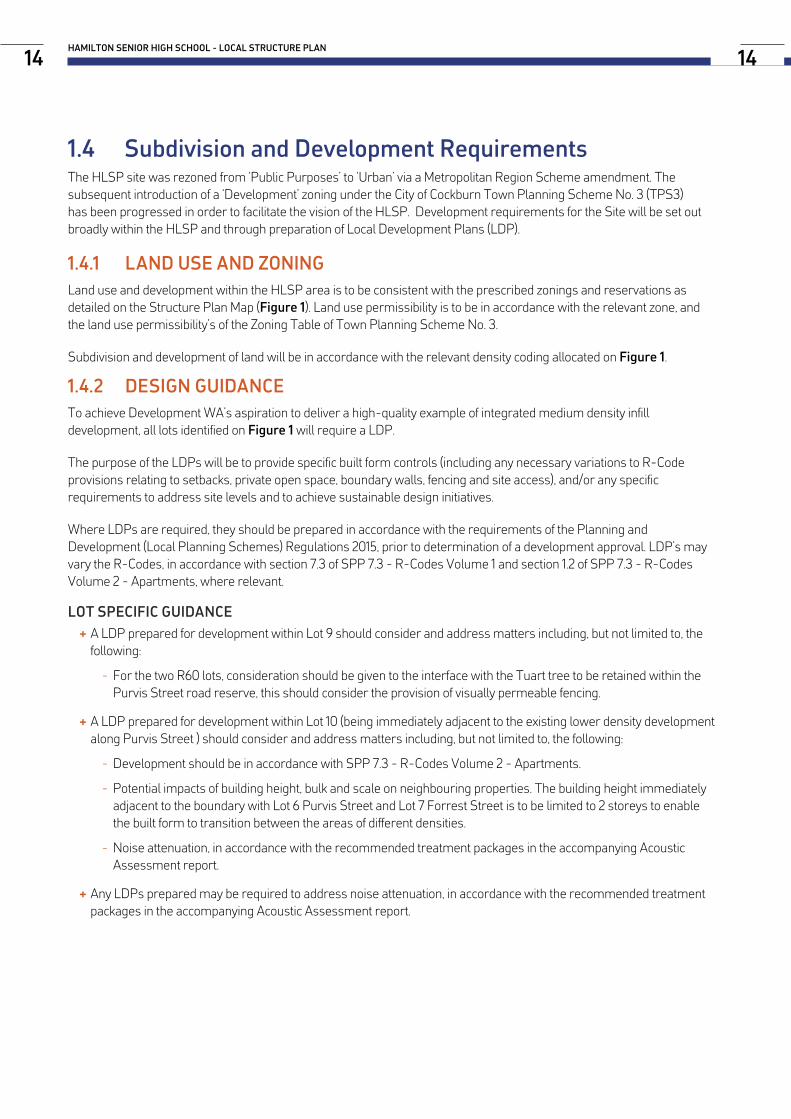
1.4 Subdivision and Development RequirementsThe HLSP site was rezoned from ‘Public Purposes’ to ‘Urban’ via a Metropolitan Region Scheme amendment. The subsequent introduction of a ‘Development’ zoning under the City of Cockburn Town Planning Scheme No. 3 (TPS3) has been progressed in order to facilitate the vision of the HLSP. Development requirements for the Site will be set out broadly within the HLSP and through preparation of Local Development Plans (LDP).
1.4.1 LAND USE AND ZONINGLand use and development within the HLSP area is to be consistent with the prescribed zonings and reservations as detailed on the Structure Plan Map (Figure 1). Land use permissibility is to be in accordance with the relevant zone, and the land use permissibility’s of the Zoning Table of Town Planning Scheme No. 3.
Subdivision and development of land will be in accordance with the relevant density coding allocated on Figure 1.
1.4.2 DESIGN GUIDANCETo achieve Development WA’s aspiration to deliver a high-quality example of integrated medium density infill development, all lots identified on Figure 1 will require a LDP.
The purpose of the LDPs will be to provide specific built form controls (including any necessary variations to R-Code provisions relating to setbacks, private open space, boundary walls, fencing and site access), and/or any specific requirements to address site levels and to achieve sustainable design initiatives.
Where LDPs are required, they should be prepared in accordance with the requirements of the Planning and Development (Local Planning Schemes) Regulations 2015, prior to determination of a development approval. LDP’s may vary the R-Codes, in accordance with section 7.3 of SPP 7.3 - R-Codes Volume 1 and section 1.2 of SPP 7.3 - R-Codes Volume 2 - Apartments, where relevant.
LOT SPECIFIC GUIDANCE + A LDP prepared for development within Lot 9 should consider and address matters including, but not limited to, the following:
- For the two R60 lots, consideration should be given to the interface with the Tuart tree to be retained within the Purvis Street road reserve, this should consider the provision of visually permeable fencing.
+ A LDP prepared for development within Lot 10 (being immediately adjacent to the existing lower density development along Purvis Street ) should consider and address matters including, but not limited to, the following:
- Development should be in accordance with SPP 7.3 - R-Codes Volume 2 - Apartments.
- Potential impacts of building height, bulk and scale on neighbouring properties. The building height immediately adjacent to the boundary with Lot 6 Purvis Street and Lot 7 Forrest Street is to be limited to 2 storeys to enable the built form to transition between the areas of different densities.
- Noise attenuation, in accordance with the recommended treatment packages in the accompanying Acoustic Assessment report.
+ Any LDPs prepared may be required to address noise attenuation, in accordance with the recommended treatment packages in the accompanying Acoustic Assessment report.
HAMILTON SENIOR HIGH SCHOOL - LOCAL STRUCTURE PLAN14 14

1.4.3 TREE RETENTIONAll trees identified on Figure 1 as ‘Potential Cockatoo Habitat Tree for Retention’ are to be protected during subdivisional and development works. The ceding of additional land to enable the Purvis Street Tuart tree to be retained within the road reserve and embellishment of this area may be required at subdivision stage.
1.4.4 TRAFFIC MANAGEMENT AND ROAD NOISEThe treatment of the intersection between the internal road network, Blackwood Avenue and Purvis Street will be finalised at subdivision stage. Additional traffic calming treatment may also be required when the internal road network is constructed, as shown on Figure 1.
A sound wall along the boundary of Stock Road is to be provided at subdivision of Stage 2, in accordance with the recommendations of Part 5 and Appendix B of the Acoustic Assessment report (Appendix D). Access to the pedestrian bridge from the site will be retained.
Lots that are identified in the Acoustic Assessment for quiet house design package treatments will also be subject to a condition at subdivision stage requiring notifications to be placed on title.
1.4.5 BUSHFIRE PROTECTIONSubdivision and development of Lots 6, 7 and 10 may require preparation of a Bushfire Management Plan by a Level 3 Bushfire Planning Practitioner to demonstrate that an appropriate Bushfire Attack Level (BAL) of BAL-29 or below can be achieved within future residential lots.
1.4.6 HIGH VOLTAGE TRANSMISSION CORRIDORAn existing 132 kV transmission line is located within the structure plan area, shown as ‘Easement’ on Figure 1. Protection of the infrastructure within the transmission line corridor is required to be formalised via an easement.
Prior to subdivision or development, Western Power will need to review, assess and provide prior written consent to any proposals within the transmission corridor.
1.4.7 ADDITIONAL REQUIREMENTSConditions may be imposed at subdivision stage to address a range of matters, including but not limited to the following:
+ Bushland management;
+ Urban water management;
+ Significant tree retention;
+ Notifications on title, where required in accordance with WAPC bushfire and road noise policies; and
+ Easements and/or notifications on title for lots adjoining or effected by the existing high voltage transmission line, shown on the Structure Plan Map as ‘Easement’.
LOCAL STRUCTURE PLAN IMPLEMENTATION NOVEMBER 201915

1.5 Staging and ImplementationAs indicated on Figure 2, staging for the HSHS redevelopment is proposed to be carried out as follows:
STAGE 1: + Bulk earthworks will be undertaken, retaining wall construction and a road connection provided to Purvis Street.
+ Connections to existing services on the western boundaries of the Site.
+ An upgrade to the sewer in Halstead Street.
STAGE 2: + A road extension through to Ralston Street will be completed, asset protection for the existing DN760 water main, creation of development of more POS areas.
+ Pedestrian connections to the Stock Road footbridge will be completed and development of the central Quad area.
+ An upgrade to the existing water main in Ralston Street will be completed along with other general servicing extensions. Additional bulk earthworks and retaining wall construction.
+ The noise wall along the Stage 2 boundary will also be constructed.
STAGE 3: + Protections around the existing Western Power transition tower, civil works servicing including bulk earthworks.
+ Completion of all road and pedestrian connections.
+ Extension of the noise wall to the required southern extent. Development of remaining POS areas.
HAMILTON SENIOR HIGH SCHOOL - LOCAL STRUCTURE PLAN16

LOCAL STRUCTURE PLAN IMPLEMENTATION NOVEMBER 2019
RALSTON STREET
STOCK RO
AD
FORREST ROAD
PURV
IS S
TREE
T
BLACKWOOD AVENUE
Pedestrian Bridge
1R400.62 ha
2R60
0.30 ha
3R60
0.34 ha
13R80
0.74 ha
12R80
0.35 ha
4R60
0.44 ha
14R80
0.42 ha
7R60
0.48 ha
6R60
0.37 ha
5R60
0.48 ha
8R60
0.57 ha
10R600.31 ha
9R400.29 ha
11R400.91 ha
STAGE 1
STAGE 2
STAGE 3
STAGE 3
© Hames SharleyHAMILTON SENIOR HIGH SCHOOL REDEVELOPMENTStructure Plan Staging
0 80
North: Project Number:Revision:Date:
Scale: 1:1000 @ A1 43711C23/10/2019
17Figure 2: Structure Plan Staging

PART TWOEXPLANATORY SECTION


2.0 INTRODUCTION & PURPOSE
+ 2.1 Structure Plan Purpose
+ 2.2 Site History
+ 2.3 Land Description
+ 2.4 Planning Framework
+ 2.5 Pre-Lodgement Engagement

2.1 Structure Plan Purpose
The City of Cockburn (the City) is a rapidly growing local government area in the south metropolitan area of Perth. The key challenges associated with this growth are providing equitable access to essential economic, social and environmental services. The City is trying to address this challenge by promoting infill development, these aspirations are set out in the City’s year Strategic Community Plan 2016-2026. The Strategic Community Plan sets a clear goal to facilitate the revitalisation of older urban areas to cater for population growth and provide greater housing diversity and choice for its residents. Limited land supply means focussing solely on greenfield development would be both short-sighted and unsustainable.
Redevelopment of the Hamilton Senior High School (HSHS) site presents a unique opportunity to meet the objectives of both the Strategic Community Plan and Hamilton Hill Revitalisation Strategy by providing infill development in Hamilton Hill. The role of the HSHS Local Structure Plan (HLSP) is to facilitate redevelopment of the HSHS site.
The purpose of the HLSP is to provide a strategic planning document that:
+ Clearly defines and articulates a vision for the HSHS site;
+ Establishes development principles and objectives; and
+ Provides a framework for future land use and development of the HSHS site.
HAMILTON SENIOR HIGH SCHOOL - LOCAL STRUCTURE PLAN22
VISIONThe Hamilton Senior High School project
connects generations of the local community providing an innovative, affordable, high quality
liveable development that celebrates the elevated site, its educational history, and the
rejuvenation of the broader area.

INTRODUCTION & PURPOSE NOVEMBER 201923
Health & H
appiness
Healthy/Active
Adapta
ble &
Live
able‘Good’ D
ensity
(Missing Middle)
+ Local identity & w
isdom
+ Participation in arts
+ Cultural heritage
+ Active meaningful life
+ Lifelong learning
+ Recreation & play
+ Connection to nature
+Connected transport
cycle/ walk/ public
transport
+Access to services
+Connected to Nature
+Consultation &
participation
+Reflect community
ambitions +
Community capacity
building
+ POS & streets
+ Building interface &
envelope
+ Deep soil zones
+ Useful outdoor space
+Building scale & form
+Economy + efficiency
+Innovative m
aterials &
build methods
Accessible & Connected
Landscape &
Streetscape Character
‘Green’ Development
Place Response
(site & context)
+Dive
rse d
emog
raph
ic
+Agin
g with
grac
e
+Gen
Y/ si
ngles
/ sha
re
+Mult
i-gen
erati
onal
Culture &
Comm
unity
Engaged & Inclusive
Daily Needs & Vibrancy
+ Embedded place
knowledge
+ Unique setting
+ Connected to context
+ Topography responseDESIGN
EXCELLENCE
INTEGRATED SUSTAINABILITY
COMMUNITY
WELLBEIN
GSafe & Secure
+ Passive surveillance + Ownership/ pride
+ Social interaction
+En
viro
nmen
tal &
se
nsor
y de
sign
/roa
d at
tenu
atio
n +
Visu
al p
rivac
y &
ac
oust
ic
+N
atur
al lig
ht &
vent
ilatio
n
+M
icro-
clim
ate
+Ur
ban
heat
isla
nd
Clim
ate
Resp
onse
Envi
ronm
ent &
Se
nsor
y D
esig
n
+ Local ‘vibe’ + Support & amenity for all life stages and abilities
Ecos
yste
ms
Was
te
Energy
Materials
Water
Dynamic & Resilient Economy
Yields & Staging
+Tr
ee ca
nopy
+U
rban
hea
t isl
and
+En
dem
ic la
ndsc
ape
+Fl
ora
& fa
una
pred
ator
s +
Loca
l & s
usta
inab
le fo
od
+Ze
ro w
aste
+Re
cycli
ng st
ream
s
+Co
mpo
st +
Adap
tive R
e-us
e
+ Sustainable materials
+ Integrated technology
+ Directions 2031 dwelling
targets + Use of land as scarce
+ m2/person (land +
dwelling) resource
+ Dwelling size
+ Materials
+ Construction methods/
times
+Sustainable
transport
+Emissions
+Zero Carbon
+ Equity & local employment + Retail needs + Start-up/ live-work
+ Comm
unity/ NFP housing
association
+ Shared facilities &
infrastructure
+ Sustainable water
+ Stormwater
+ Rainwater
+ Water efficiency
Finance & Tenure
Models
Affordable Housing
ENVIRONMENTAL
RESPONSIBILITY
ECONOMIC
HEALTH
Affordable Living
+Affordable lifestyle
+Management &
maintenance of public
realm
Figure 3: HLSP EnviroDevelopment
2.1.1 PROJECT VISIONThe Hamilton Senior High School Redevelopment will set a new standard for residential infill development across the four elements of: Community Wellbeing, Environmental Responsibility, Economic Health and Design Excellence. The project seeks to demonstrate how urban infill can mitigate the effects of urban heat through design, material choices and water management to create a healthy, highly liveable community with a dramatically lower environmental footprint.
Figure 3 illustrates how the HLSP responds to both the project and EnviroDevelopment objectives.

2.1.2 OBJECTIVESCOMMUNITY AND WELLBEING
+ Facilitate intergenerational equity and ageing in place through diverse housing typologies.
+ Enhance shared amenity and the quality of the public realm to foster community cohesion.
+ Utilise alternative design methods to be innovative in the provision of Public Open Space.
+ Respect and respond to the indigenous and cultural history of the site.
ENVIRONMENTAL RESPONSIBILITY
+ Maximise tree canopy coverage by replacing or retaining (where possible) existing trees.
+ Direct sustainable practices through precinct wide water and energy sensitive initiatives.
+ Apply innovative design strategies to address noise and air pollution.
+ Apply best practice in water systems and seek Waterwise Development endorsement from Water Corporation.
DESIGN EXCELLENCE
+ Create high quality development that reflects and respects the character of the place.
+ Demonstrate adaptable and alternative building techniques within the development.
+ Encourage innovative housing models through flexible site layouts.
+ Ensure all dwellings address passive solar and ventilation principles.
ECONOMIC HEALTH
+ Provide affordable housing and living opportunities in partnership with others.
+ Optimise housing value of surrounding residential areas.
+ Offer a streamlining process for planning applications which detail innovative solutions.
+ Support local retail and commercial activities.
THIRD PARTY REVIEW OF DESIGN
+ The project will target EnviroDevelopment accreditation under all six elements of the framework: Ecosystems, Waste, Materials Energy, Water and Community.
+ The target will engage with leading heat stress researchers during the design phase in order to validate the design against best practice.
+ Review the design for consistency with the Cooperative Research Centre for Water Sensitive Cities Strategic Plan to create a healthy, heat resilient community with best practice in water efficiency, sourcing and management.
HAMILTON SENIOR HIGH SCHOOL - LOCAL STRUCTURE PLAN24

HSHS was built in 1962 having been identified as a high school site within the 1955 Stephenson and Hepburn Plan and later the 1963 Metropolitan Region Scheme. Ever since, it had been reserved accordingly as ‘Public Purposes - High School’ under the Metropolitan Region Scheme (MRS). This changed in May 2018 when the WAPC formally approved an amendment to the MRS which saw the Site rezoned to ‘Urban’.
The school complex has been extended a number of times, primarily incorporating red brick two-storey buildings with ancillary sheds, pool, ovals and fencing.
2.2 Site History
HSHS Site - 1953 HSHS Site - 1962 HSHS Site - 2017
In December 2014 the Minister for Education announced that HSHS and the South Fremantle Senior High School sites would close towards the end of 2017 due to low current and projected enrolments. Both schools were amalgamated in 2018 to form Fremantle College located on the existing South Fremantle campus. The Department of Education has advised that anticipated growth and redevelopment in the Fremantle/ Cockburn area has been fully assessed in the planning for the amalgamation of the secondary schools. If further capacity is required in the longer term as a result of greater than anticipated population growth in the catchment, the Fremantle Campus site will be able to accommodate the additional demand.
The relocation presents a unique opportunity to repurpose the land for residential development. LandCorp executed a contract of sale to purchase the HSHS site from the Department of Lands in 2017. Settlement of the school site occurred on 8th of January 2018, therefore LandCorp are now the official owners of the HSHS site.
INTRODUCTION & PURPOSE NOVEMBER 201925

2.3 Land Description
The HLSP area is defined by the boundary indicated on Figure 4. The HLSP area comprises Lot 850 (8) Purvis Street (Reserve: 37938). The HLSP area (to be referred to as the Site) totals 11.9 hectares. It is bounded by Ralston Road to the north, Stock Road to the east, Forrest Road to the south, and Purvis Street to the west.
Figure 4: HLSP Area
HAMILTON SENIOR HIGH SCHOOL - LOCAL STRUCTURE PLAN26

2.4 Planning Framework
2.4.1 ZONING AND RESERVATIONSMETROPOLITAN REGION SCHEMEThe Site was reserved under the MRS as ‘Public Purpose – High School’. An MRS amendment request was lodged with the Department of Planning in November 2016. This request was approved by the Minister for Planning (on May 22, 2018). The MRS amendment includes the transfer of approximately 11.9 hectares of land from ‘Public Purposes – High School’ reservation to ‘Urban’ and 8,218m2 to ‘Primary Regional Road’. The MRS amendment will enable residential development to occur on the Site.
CITY OF COCKBURN TOWN PLANNING SCHEME NO.3The City of Cockburn Town Planning Scheme No. 3 (TPS3) was gazetted on 20 December 2002. In order to understand the long term objectives for the locality, TPS3 has been read in conjunction with the City’s Local Planning Strategy, which sets out the long-term planning directions for the municipality as well as the rationale for the zones and other provisions of TPS3.
Subsequent to the MRS amendment, an amendment to TPS3 was prepared. The amendment saw the Site rezoned to ‘Development’ necessitating the need for a structure plan to guide future planning and development.
Figure 5: TPS3 Zoning Extract
INTRODUCTION & PURPOSE NOVEMBER 201927
2.4.2 STATE AND REGIONAL PLANNING FRAMEWORKSTATE PLANNING STRATEGY 2050 (2014)The State Planning Strategy is the lead strategic planning document within Government. It acts as a guide and highlights principles, strategic goals and strategic directions that are important to future land-use planning and development in WA.
The document highlights the key drivers of change set to influence WA. ‘Population’ and ‘urbanisation and regional expansion’ are the two drivers most pertinent to the HLSP. Population growth and ageing will dramatically impact the social composition of our communities, whilst urbanisation is seeing a greater majority of the population living in urban areas.
The HLSP aligns with the State Planning Strategy by addressing the priorities of Strategic Goal 3 - Sustainable Communities, which are:
+ Diversity - community-specific development, responsive to diverse needs, places and contexts;
+ Liveability - communities with attractive, liveable environments;
+ Connectedness - providing natural and built connections within and between communities; and
+ Collaboration - collaborative and inclusive planning.
STATE PLANNING POLICY 3 - URBAN GROWTH AND SETTLEMENTSPP 3 sets out the principles and considerations which apply to planning for urban growth and settlement in WA. The policy outlines the need to prioritise infill development in Perth to capitalise on existing infrastructure services and job opportunities, as well as building on the character of existing communities. Developing in established communities enables existing infrastructure, character and amenity to be leveraged off.
The HLSP is consistent with the intentions of SPP3 by providing redevelopment opportunities in an already established urban area.
STATE PLANNING POLICY 3.1 - RESIDENTIAL DESIGN CODESThe Residential Design Codes (R-Codes) provide a basis for administering the control of residential development in Western Australia. The R-Codes aim to address emerging design trends, promote sustainability, improve clarity and facilitate better residential design outcomes.
As mentioned in Section 2.4.1, an MRS amendment was approved by the WAPC in May 2018 to rezone the Site ‘Urban’. This would enable an amendment to the City’s TPS3 which would see residential development permitted on the Site. If residential development is permitted, the HLSP will have consideration for the provisions of the R-Codes.
STATE PLANNING POLICY 3.7 - PLANNING IN BUSHFIRE PRONE AREASThe intent of SPP 3.7 is to implement effective, risk-based land use planning and development to preserve life and reduce the impact of bushfire on property and infrastructure. The Department of Fire and Emergency Services (DFES) map of bush fire prone areas indicates that a significant portion of the Site is situated within bushfire prone areas, therefore a Bushfire Management Plan (BMP) is required.
The HLSP is supported by a BMP which has been prepared by Strategen Environmental. The BMP indicates that the bushfire hazards within and adjacent to the Site and the associated bushfire risk is readily manageable through standard management responses outlined in the Guidelines and AS 3959. The BMP is supplied in Appendix M.
STATE PLANNING POLICY 5.4 - ROAD AND RAIL NOISESPP 5.4 sets out principles that apply to road and rail transport noise and considerations to the planning of land uses. The policy outlines the affects that such noise can have on amenity and human health and considers the management of transport noise and its impacts on development.
HAMILTON SENIOR HIGH SCHOOL - LOCAL STRUCTURE PLAN28
The policy specifically applies to cases where a proposed new noise-sensitive development is located in the vicinity of an existing major road. Due to the Site’s location adjacent to Stock Road noise mitigation measures are required. A noise assessment was undertaken by Lloyd George Acoustics, provisions for a noise wall have been made. This is detailed in Appendix D.
STATE PLANNING POLICY 7.0 - DESIGN OF THE BUILT ENVIRONMENTState Planning Policy 7.0 Design of the Built Environment (SPP 7.0) forms part of the State Government’s Design WA initiative which seeks to ensure all development proposals promote good design. SPP 7.0 identifies ten overarching design principles which are required to achieve good design.
SPP7 outlines ten key principles of ‘good design’ - context and character, landscape quality, built form and scale, functionality and build quality, sustainability, amenity, legibility, safety, community and aesthetics. The HLSP takes into account these principles by providing a site responsive design. In addition, at the LDP stage grouped housing sites will have consideration for the State Planning Policy 7.3 - Residential Design Codes Volume 2 - Apartments.
PERTH AND [email protected] MILLION (2015) The Perth and [email protected] suite of strategic land use planning documents provide a framework for future growth in the Perth and Peel regions. The strategy recognises the benefits of a consolidated and connected city utilising the region’s previous historic patterns of urban growth. It is divided into four sub-regional frameworks, which provide more detailed guidance on future land use and development for a city of 3.5 million people. The frameworks provide for different lifestyle choices, vibrant nodes for economic and social activity and a more sustainable urban transport network.
The City of Cockburn is guided by the South Metropolitan Peel Sub-Regional Framework. The framework outlines that the City has an urban infill dwelling target of 8,599 by 2031 and 14,678 by 2050. Whilst not identified as a location for urban infill, the HLSP provides a good opportunity to enable the City to meet its infill targets by contributing to urban consolidation through facilitating development in an already established area.
LIVEABLE NEIGHBOURHOODSLiveable Neighbourhoods is a WAPC operational policy which aims to implement the objectives of the State Planning Strategy, guiding sustainable development in Western Australia. It addresses both strategic and operational aspects and can be applied in the design and assessment of structure plans and subdivision for new urban areas in the Perth Metropolitan Region. Liveable Neighbourhoods is applied in the City of Cockburn in the design and approval of urban development, structure planning and subdivision for greenfield sites and for the redevelopment of large brownfield and urban infill sites.
INTRODUCTION & PURPOSE NOVEMBER 201929

2.4.3 LOCAL PLANNING FRAMEWORK
CITY OF COCKBURN LOCAL PLANNING STRATEGY (2000)The City of Cockburn Local Planning Strategy (LPS) sets out the long-term planning directions for the City and provides the rationale for the zones and other provisions of the Town Planning Scheme. The purpose of the LPS is to provide the strategic planning context for the Town Planning Scheme, reflecting the broader regional context. The LPS outlines future actions to achieve the objectives of the strategy within a 15-20 year timeframe. The LPS recognises a key strategic issue for the City is that of infill housing and recommends this be a key strategy in older established suburbs, specifically Hamilton Hill.
The opportunity for more infill is recognised in this area, as future infill housing development is limited in other suburbs. The HLSP recognises that redevelopment of Hamilton Senior High School provides a significant opportunity to address this key objective through the provision of increased density and housing diversity.
CITY OF COCKBURN COMMUNITY STRATEGIC PLAN 2016-2026The City of Cockburn Strategic Community Plan 2016-2016 forms part of the local government integrated planning and reporting framework. The Strategic Community Plan provides a link between community aspirations and Council’s vision and long term strategy. The Plan is underpinned by five strategic objectives:
+ City Growth;
+ Moving Around;
+ Economic, Social and Environmental Responsibility;
+ Community, Lifestyle and Security; and
+ Leading and Listening.
The HLSP aligns with these objectives by providing an infill development in an established area that seeks to promote housing choice and diversity; protect the natural environment; manager water, energy and waste efficiency; and foster a sense of community through a network of public open spaces.
PUBLIC OPEN SPACE STRATEGY 2014-2024The Public Open Space Strategy 2014-2024 was adopted by the City of Cockburn in October 2014. The document outlines the multiple benefits of public open space and provides guidance for the enhancement and management of open space as well as the future allocation of these spaces. The Strategy provides an opportunity to identify shortfalls in local and district open space within the City. To meet future population growth, the POS strategy outlines various greenfield and infill development sites suitable for provision of POS.
Despite the Site not being identified as one of these locations, the HLSP has made a conscious effort to celebrate the natural landscape.
HAMILTON HILL REVITALISATION STRATEGY (2012)The City’s Revitalisation Strategy outlines how infill development should be delivered in Hamilton Hill in response to regional requirements. The strategy includes proposed changes to residential densities, land consolidation bonuses, proposed changes to the Residential Design Guidelines Policy, a POS improvement strategy and recommendations for the local centre and movement networks. Hamilton Hill is recognised as an inner ring suburb well situated to contribute towards the City’s infill targets.
The HLSP has capacity to facilitate approximately 312 dwellings as part of the redevelopment. This incorporates a diverse mix of lot and dwelling typologies suitable to a range of household types.
HAMILTON SENIOR HIGH SCHOOL - LOCAL STRUCTURE PLAN30

2.5 Pre-Lodgement Engagement
2.5.1 STAKEHOLDER ENGAGEMENT SUMMARYAn extensive stakeholder engagement process has been undertaken in the development of the HLSP. Preliminary engagement commenced in August 2016. As demonstrated in Table 1 stakeholder engagement has involved collaboration with a variety of groups such as HSHS staff and students, local Indigenous and other community groups and the City of Cockburn.
Table 1: Pre-Lodgement Engagement Summary
DATE EVENT ATTENDEES19/08/16 Hamilton SHS Principal
and Manager, Corporate Services – meeting
+ Donna McDonald + Suzanne Duncan + Naomi Lawrence (NL) Warren Phillips (WP) (LandCorp)
+ Catherine Bentley (CB), Paul Gazzone (PG) (LandCorp)
19/08/16 City of Cockburn (CoC) - on-site meeting
+ Daniel Arndt (CoC) + Ian McRae
+ CB, WP, NL, PG (LandCorp)
01/09/16 Department of Planning – meeting
+ Andrew Thomas + Ian McRae
+ PG, NL (LandCorp)
16/09/16 President Hamilton Hill Community Group (HHCG) – briefing
+ Tobias Busch + WP, NL, CB (LandCorp)
19/09/16 CoC consultation group + Deanie Carbon (CoC) + Samantha Mourish (CoC)
+ Simone Sieber (CoC) + CB, NL
21/09/16 HHCG presentation + Carole Reeves-Fowkes (CoC Deputy Mayor)
+ Kevin Allen (CoC Ward Councillor)
+ Approx. 20 HHCG members + CB, WP, NL (LandCorp)
12/10/16 CoC – meeting + Donna Di Renzo (CoC) + Andrew Trosic (CoC)
+ NL (LandCorp) + Hames Sharley
14/10/16 Tour of White Gum Valley + Logan Howlett (CoC Mayor) + Simone McGurk (MLA) + Simone Sieber (CoC)
+ HHCG members + LandCorp Exec + WP
30/11/16 Community Forum + Community members + Logan Howlett (CoC Mayor) + Daniel Arndt (CoC)
+ LandCorp Community Relations &
+ Project Team
15/03/17 Presentation to SWALSC – Whadjuk Working Group
+ Ingrid Cumming (Codeswitch) + CB, WP, NL (LandCorp)
05/04/17 Year 10 – 12 Hamilton SHS students
+ Ailsa Grieve (Landscript) + Ingrid Cumming (Codeswitch)
+ Year Ten and Twelve students + NL, WP (LandCorp)
05/04/17 Open forum for local Aboriginal Community
+ Mark Jumeaux (Josh Byrne and Associates)
+ Miles Draper (Fremantle College) + Claire Paddison (CP) (LandCorp)
+ Ailsa Grieve (Landscript) + Ingird Cumming (Codeswitch) + WP (LandCorp) + Prof Len Collard
16/05/17 CoC – Aboriginal Reference Group briefing
+ Samantha Mourish (CoC) + Sally Ann Gamble (Chair) + Len Thorn (Co-Chair) + Leah Bonson + Gail Bowman
+ Gail Thorn + Maisie Stokes + Saskia Mackay (SM) + WP, NL, CP, SM (LandCorp)
INTRODUCTION & PURPOSE NOVEMBER 201931

DATE EVENT ATTENDEES17/05/17 HHCG presentation + Logan Howlett (CoC Mayor)
+ Lyndsey Sweetman (CoC West Ward Councillor)
+ Chamonix Terblanche (CoC East Ward Councillor)
+ Rachel Seal (Hames Sharley) + Ingrid Cumming (CodeSwitch) + Approx. 25 HHCG members + Lauren Hurst (LH) + WP, NL, SM
08/06/17 Smart Cities Presentation + Keith Fitzpatrick, Andrew Trosic, Daniel Arndt, Nelson Mauricio, Charles Sullivan, Anton Lees, Don Green, Stuart Downing, Linda Seymour, Andrew Lefort, Samantha Seymour-Eyles, Margot Tobin (CoC)
+ Gail Bowman, Doug Vickery, Christopher Beaton and Hana Jestribek (CoC)
+ Josh Byrne and Mark Taylor (Josh Byrne and Associates)
+ NL and WP (landCorp
14/06/17 Meeting with City of Cockburn - Site Analysis and Concepts
+ Donna Di Renzo and Andrew Trosic (CoC)
+ NL and WP (LandCorp)
+ Rachel Seal and Ryan Dunham (Hames Sharley)
26/07/17 CoC – Presentation of Draft Concept Plan plus CBEH pilot trial demonstration
+ Andrew Trosic (CoC) + Donna Di Renzo (CoC) + Gail Bowman (CoC) + Simone Sieber (CoC) + Barbara Freeman (CoC)
+ Rachel Seal and Ryan Dunham (Hames Sharley)
+ Jonathon Small (Tabec) + Dr Paula Hooper (UWA CBEH) + WP, NL (LandCorp)
05/08/17 Community Information Session– Hamilton
Hill, Memorial Hall
+ Approx. 70 members of the community
+ Josh Wilson MP, Federal Member for Fremantle
+ Logan Howlett (CoC Mayor) + HHCG members
+ Cockburn Wildlife Community Corridor members
+ Dr Paula Hooper (UWA CBEH) + Felicity Carlin (LandCorp) + Matt Read (MR) WP, NL, LH, CB (LandCorp)
19/09/17 Aboriginal Reference Group Briefing
+ Samantha Mourish (CoC) + Sally Ann Gamble (Chair) + Len Thorn (Co-Chair) + Leah Bonson + Gail Bowman
+ Gail Thorn + Maisie Stokes + LH & CP (LandCorp)
Apr / May - 2018
Pre Lodgement Stakeholder Briefing
+ Daniel Arndt, Donna Di Renzo and Andrew Trosic (CoC)
+ Minister for Planning + Cockburn Community Wildlife Corridor Representatives
+ Hamilton Hill Community Group (including Mayor, Deputy Mayor and 2 Ward Councillors)
+ MR and NL (LandCorp)
HAMILTON SENIOR HIGH SCHOOL - LOCAL STRUCTURE PLAN32

2.5.2 ABORIGINAL ENGAGEMENTCodeswitch were engaged to prepare and undertake an Aboriginal Engagement Strategy. The focus of the strategy was to work with the Noongar community, with aims to:
+ Create an environment that actively supports and drives Aboriginal participation in the HSHS Redevelopment project, which is appropriate to the needs and expectations of Aboriginal people and organisations; and
+ Ensuring that Aboriginal people have the opportunity to engage appropriately, including providing input into the design of the transformation of the school site.
The findings of the Aboriginal Engagement Strategy recommended that to adequately represent the Wadjuk, Noongar and wider Aboriginal community of HSHS the HLSP should:
HONOUR HISTORY INCORPORATE LOCAL KNOWLEDGE
HONOUR FAMILIES AND COMMUNITY
HONOUR HISTORYA chance to give more exposure to the stories both pre-and post-colonial period to be told through interpretive walks throughout the site and surroundings and inevitably connected to the site.
INCORPORATE LOCAL KNOWLEDGEThe project should consider the integration of local Wadjuk Noongar knowledge, in particular the celebration of the flora and fauna of the area, the uses and using the language in relation to these.
HONOUR FAMILIES AND COMMUNITY: The project needs to honour the families who have contributed and been a part of the local area for generations. Some initial ideas given the past connections and history, heritage and feedback from community may be, but are not limited to:
+ Noongar specific procurement through the project from advisors, earthworks, site surveyors and artists;
+ Installation of acknowledgement plaques, installations or designs that celebrate Noongar sense of place and connection using the information in the attachments in this report;
+ Using language in street names, naming of parks and open spaces; and
+ Retaining and reintroducing native flora in the area to help the cultural and physical Noongar connection to country on the site.
A copy of the Aboriginal Engagement Strategy is provided in “Appendix K - Aboriginal Engagement Strategy”.
INTRODUCTION & PURPOSE NOVEMBER 201933


3.0 CONTEXT ANALYSIS
+ 3.1 Regional Context
+ 3.2 Local Context
+ 3.3 Demographic Profile
+ 3.4 Market Profile

3.1 Regional Context
The Site is located within the City of Cockburn in the suburb of Hamilton Hill. It is located at the intersection of Stock Road and Ralston Street and is approximately 17 km southwest of the Perth Central Business District (CBD), 6km southeast of the Fremantle Strategic Metropolitan Centre (SMC) and 7km northwest of the Cockburn Secondary Centre.
3.1.1 ACTIVITYAs illustrated on Figure 6, the Site is situated in close proximity to a number of activity centres which provide a range of employment, entertainment and social services. In 2011, 75.3% of the City’s residents worked outside of the City, this low level of employment self-containment suggests that almost three quarters of local residents leave the area on a daily basis for work. As the largest activity centre, it is likely that a large proportion of residents travel to the Perth CBD for employment, however, it is unlikely that it is the primary centre for other services.
Due to its proximity, is assumed that the Fremantle SMC serves as the major employment and entertainment node for residents of Hamilton Hill. However, the Site also has access to a range of other centres including:
+ Booragoon and Cockburn Secondary Centres;
+ Spearwood and North Coogee District Centres:
+ Murdoch and Jandakot Specialised Centres; and
+ Henderson, Bibra Lake, O’Connor and Myaree Industrial Centres.
The above centres provide local residents with access to a number of diverse employment centres not often experienced in a 5-10km catchment. This diversity of access and choice could be attractive for future residents of the HSHS redevelopment.
3.1.2 MOVEMENTFrom a public transport perspective, the closest train stations are located in Fremantle (6km) and Murdoch (5.5km). For access to Perth it is likely that people drive to Murdoch Station to utilise the ‘park n ride’ facilities as this route is significantly quicker than using the train from Fremantle which has less parking and a longer journey time.
The area is serviced by the TransPerth bus network, which provides links to key services in the surrounding area, including the Murdoch, Fremantle and Cockburn Train Stations.
The Site has access to a number of major arterial roads. Stock Road is the primary north-south connector, providing access to key east-west connectors such as Winterfold Road and South Street, which provides links to Fremantle, Murdoch and the Perth CBD (via South Street).
3.1.3 CHARACTERThe region has a predominantly urban character, however, the Site is in close proximity to key natural assets such as Bibra Lake (2.5km), Beeliar Regional Park (4.5km) and the coastline. Popular beaches in close proximity to the Site include CY O’Connor Reserve and South Beach.
The Site is also located close to key entertainment districts such as Fremantle, South Fremantle, Cockburn, and Adventure World which is Perth’s only theme park.
HAMILTON SENIOR HIGH SCHOOL - LOCAL STRUCTURE PLAN36

Figure 6: Regional Context
CONTEXT ANALYSIS NOVEMBER 201937

3.2 Local Context
3.2.1 ACTIVITYFigure 7 highlights the findings of the data obtained from the University of Western Australia (UWA) Centre of Built Environment and Health (CBEH). It illustrates the dwellings in the local catchment that are within 400m of a local neighbourhood centre, and demonstrates that approximately less than half of the dwellings located within 3000m of the Site have access to a local neighbourhood centre.
The broader locality is generally well serviced by basic amenities including retail, education, open space and retail. The Spearwood District Activity Centre has the largest and most diverse offering in the local catchment. Phoenix Shopping Centre includes a Coles, Woolworths, Big W and a range of specialty tenancies, fast food restaurants and other supporting retail services.
A key challenge facing the Site is that the retail offering in the immediate walkable catchment is lacking. The closest shopping centres are Hamilton Hill IGA X-Press (600m) and Coolbellup IGA (1km). The IGA X-Press has a limited retail offering and access to Coolbellup IGA for pedestrians requires pedestrians to cross the Stock Road pedestrian bridge. There is an obvious need for amenities in the immediate catchment of the Site, as such opportunities to provide a small retail offer are being considered.
HAMILTON SENIOR HIGH SCHOOL - LOCAL STRUCTURE PLAN38
Figure 7: Walkability and AmenitySource: UWA, CBEH 2017
0 1Km
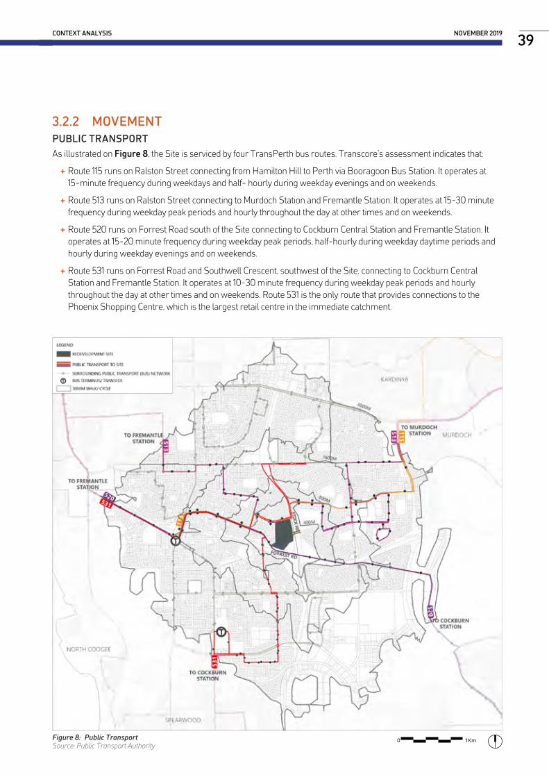
3.2.2 MOVEMENTPUBLIC TRANSPORTAs illustrated on Figure 8, the Site is serviced by four TransPerth bus routes. Transcore’s assessment indicates that:
+ Route 115 runs on Ralston Street connecting from Hamilton Hill to Perth via Booragoon Bus Station. It operates at 15-minute frequency during weekdays and half- hourly during weekday evenings and on weekends.
+ Route 513 runs on Ralston Street connecting to Murdoch Station and Fremantle Station. It operates at 15-30 minute frequency during weekday peak periods and hourly throughout the day at other times and on weekends.
+ Route 520 runs on Forrest Road south of the Site connecting to Cockburn Central Station and Fremantle Station. It operates at 15-20 minute frequency during weekday peak periods, half-hourly during weekday daytime periods and hourly during weekday evenings and on weekends.
+ Route 531 runs on Forrest Road and Southwell Crescent, southwest of the Site, connecting to Cockburn Central Station and Fremantle Station. It operates at 10-30 minute frequency during weekday peak periods and hourly throughout the day at other times and on weekends. Route 531 is the only route that provides connections to the Phoenix Shopping Centre, which is the largest retail centre in the immediate catchment.
CONTEXT ANALYSIS NOVEMBER 201939
Figure 8: Public TransportSource: Public Transport Authority
0 1Km

ACTIVE TRANSPORTExisting active transport routes around the Site are shown on Figure 9, which is taken from the Department of Transport’s Perth Bike Map series. There is a footbridge over Stock Road on the eastern side of the Site area with shared path connections northward on both sides of Stock Road. There are no on-road cycling facilities on Stock Road.
Ralston Street and the footbridge are part of Perth Bicycle Network route SW18. There are bicycle lanes or sealed shoulders on Forrest Road and Winterfold Road, whilst Curven Road, O’Connell Street and Redmond Road are classed as a good road riding environment providing links to Forrest Road and Winterfold Road. There are opportunities to reroute the PBN through the Site, via the existing pedestrian bridge, increasing connectivity and potentially attracting people to the open space provided in the redevelopment.
The existing urban structure of the local catchment is defined by the road network, which has significant impacts on pedestrian connectivity. Stock Road and Forest Road provide major barriers and limit pedestrian movement to the south and east. This highlights the importance of the footbridge across Stock Road as it is the only existing pedestrian connection east of the Site.
HAMILTON SENIOR HIGH SCHOOL - LOCAL STRUCTURE PLAN40
Figure 9: Active TransportSource: Department of Transport
0 1Km

VEHICLE TRANSPORTStock Road is located to the east of the Site. It is classified by Main Roads WA (MRWA) as a Primary Distributor road in the catchment. It is a dual carriageway with two lanes in each direction. The central median varies in width but is approximately 6m wide adjacent to the Site. There are currently signalised 4-way intersections on Stock Road at Forrest Road (south of the Site) and Winterfold Road (over 900m north of the Site). Ralston Street connects to Stock Road at a full-movement T-intersection, which is the only intersection on the western side of Stock Road between Forrest Road and Winterfold Road.
As illustrated on Figure 10 key roads in the local catchment include:
+ Phoenix Road - Distributor A road providing east-west connection between Rockingham and North Lake Roads. 4-way signalled intersection with Stock Road;
+ Rockingham Road - Distributor A road providing north-south connections between Kwinana and Fremantle;
+ North Lake Road - Distributor A road providing north-south connections between Cockburn Secondary Centre and South Street; and
+ Forest Road - Distributor B road providing connections between North Lake Road and Rockingham Road.
CONTEXT ANALYSIS NOVEMBER 201941
Figure 10: Vehicle TransportSource: Main Roads Western Australia
0 1Km

HAMILTON SENIOR HIGH SCHOOL - LOCAL STRUCTURE PLAN42
3.2.3 CHARACTERPUBLIC OPEN SPACEFor the purpose of this analysis Public Open Space (POS) is used to refer to all land identified within the City’s TPS as ‘Parks and Reservation” as well as any future POS identified in the City’s Public Open Space Strategy 2014 - 2024. POS areas have been delineated as either active, passive or future. Active POS areas are identified as any areas which contain formalised sporting fields or equipment. Passive POS areas align with leisure and community needs and contain community facilities such as, a playground or gazebo. Future POS areas are as identified within the City’s Public Open Space Strategy 2014 - 2024.
Figure 11 illustrates that there are currently no active or passive POS areas provided within the 400m walkable catchment of the Site, however, the natural bushland surrounding the intersection of Stock/Forrest Road contains a number of tracks suggesting these areas are used informally. Redevelopment of the Site should consider opportunities for provision of POS, to reflect its past history and character as a school and to improve community amenity and activation.
As mentioned in “3.1.3 Character”, the surrounding area has access to a number of regional open space areas and the coastline.
Figure 11: Open SpaceSource: UWA, CBEH 2017
0 1Km

CONTEXT ANALYSIS NOVEMBER 201943
3.3 Demographic Profile
In order to understand the social context of the HLSP area, Australian Bureau of Statistics (ABS) 2016 Census data and REIWA data has been analysed. For the purposes of this study, the Hamilton Hill suburb has been analysed and benchmarked against City of Cockburn and Greater Perth data (study area illustrated on Figure 12).
All data has been sourced from the ABS 2016 census unless otherwise stated.
HAMILTON HILL
Population 10,387
Median Age 40
Families 2,607
Dwellings 5,057
Household Size 2.3
CITY OF COCKBURN
Population 104,473
Median Age 35
Families 28,305
Dwellings 42,827
Household Size 2.7
GREATER PERTH
Population 1,943,858
Median Age 36
Families 515,328
Dwellings 818,081
Household Size 2.6
Figure 12: Study Area
HAMILTON HILL
CITY OF COCKBURN
GREATER PERTH
GREATER PERTH

HAMILTON SENIOR HIGH SCHOOL - LOCAL STRUCTURE PLAN44
3.3.1 DEMOGRAPHIC SNAPSHOTPOPULATION GROWTHPopulation in Hamilton Hill increased from 9,257 in 2006 to 10,387 in 2016 representing a growth rate of 10.9%. Over the same period the City of Cockburn experienced a growth rate of 28.7%. The slower growth rate in Hamilton Hill can be attributed to the limited availability of land and reliance on infill redevelopment, in contrast much of the City of Cockburn’s growth throughout this period occurred via greenfield subdivision.
Population forecasts by .idcommunity project the population in Hamilton Hill to reach 16,557 by 2036, representing a growth rate of 37.3%. The projected growth will likely be a result of the City’s increased focus on infill development, the HLSP is an example of this development with potential to provide housing for over 800 people.
AGE PROFILEHamilton Hill has a much older population, its median age is 40 which is five and four years older than the City of Cockburn and Greater Perth median ages respectively. As illustrated in Table 2 this is due to a much larger percentage of people aged 65 and over and smaller percentages of people aged 0-24. This presents opportunities to provide housing options in the HLSP that are better suited to young people.
Table 2: Age Profile Comparison
Hamilton Hill City of Cockburn Greater Perth
0-14 15.6% 20.1% 19.0%
15-24 10.3% 12.5% 13.1%
25-44 30.5% 31.8% 29.7%
45-64 24.9% 24.1% 24.2%
65 and over 18.7% 11.7% 13.9%
FAMILY COMPOSITION
As demonstrated in Table 3 Hamilton Hill has a higher percentage of families without children and single parent families, and a significantly lower percentage of couple families with children. The higher percentage of families without children is reflective of the suburbs older population which is likely to have a number of households that include either ‘empty nesters’ or retirees. The higher percentage of single parent families highlights the need to provide a range of dwelling options in the HLSP, that provide opportunities for a range of family types.
Table 3: Family Composition Comparison
Hamilton Hill City of Cockburn Greater Perth
Couple family without children 40.0% 35.0% 37.5%
Couple family with children 35.5% 48.9% 46.3%
Single parent family 22.6% 14.5% 14.5%
Other family 1.9% 1.6% 1.8%

CONTEXT ANALYSIS NOVEMBER 201945
HOUSEHOLD TYPEHamilton Hill had a significantly lower proportion of family households and much higher percentage of single or lone person households compared to the City of Cockburn and Greater Perth. 56.3% of single person households in Hamilton Hill live in separate houses, yet 85.6% of separate houses are comprised of three bedrooms or more. This data indicates that there is a current gap in the housing market for single person households.
Table 4: Household Types
Hamilton Hill City of Cockburn Greater PerthFamily 61.8% 75.8% 73.0%Single or Lone Person 32.7% 20.7% 23.0%Group Household 5.5% 3.5% 4.0%
INCOMECompared to the City of Cockburn and Greater Perth Hamilton Hill is not a very wealthy suburb, it has much lower median weekly personal, family and household incomes. The lower incomes can be attributed to a number of elements such as the high percentage of single parent families and retirees, which is a byproduct of the high concentration of Department of Communities assets in the area.
Table 5: Income Comparison
Hamilton Hill City of Cockburn Greater PerthPersonal $608 $761 $728Family $1,520 $2,038 $1,955Household $1,166 $1,756 $1,643
LABOUR FORCE PARTICIPATIONHamilton Hill had a lower percentage of people who worked full-time but higher percentage of people who worked part-time compared to the City of Cockburn and Greater Perth. However, it had a much higher unemployment rate.
Table 6: Labour Force Participation Comparison
Hamilton Hill City of Cockburn Greater PerthWorked full-time 56.6% 61.5% 60.2%Worked part-time 30.1% 27.7% 28.9%Away from work 7.2% 6.5% 6.1%Unemployed 6.1% 4.3% 4.8%
Source: ABS, 2011 (2016 census data available in October 2017)
COUNTRY OF BIRTHHamilton Hill had a lower percentage of people born in Australia compared to both the City of Cockburn and Greater Perth. The top five countries of birth in Hamilton Hill are identified in Table 7. It had a much higher percentage of Italian and Portugese residents and comparable percentages of people from England, New Zealand and Philippines.
Table 7: Country of Birth
Hamilton Hill City of Cockburn Greater PerthEngland 6.4% 6.8% 8.6%Italy 4.6% 1.5% 0.9%New Zealand 2.9% 3.1% 3.2%Philippines 2.4% 2.3% 1.3%Portugal 1.5% Not in top 50 Not in top 50

HAMILTON SENIOR HIGH SCHOOL - LOCAL STRUCTURE PLAN46
HAMILTON HILL SOCIAL CHANGE 2006-2016Table 8: Social Transition in Hamilton Hill
ELEMENTHAMILTON HILL
CHANGE COMMENT2006 2016
AGE STRUCTURE0-1415-2425-4445-6465 and over
16.4%12.1%28.5%25.1%17.8%
15.6%10.3%30.5%24.9%18.7%
-0.8%-1.8%+2.0%-0.2%+0.9%
+ The median age in Hamilton Hill increased from 39 to 40.
+ Reduction in people aged 15-24 could be a result of lack of housing choice. Increase in persons aged 65 and over reflective of Greater Perth trends.
MEDIAN INCOME1
PersonalFamilyHousehold
$479$1,180$890
$608$1,520$1,166
+ $129+ $340+ $276
+ Increase in median weekly personal, family and household incomes suggests the population in Hamilton Hill could be becoming wealthier.
FAMILY STRUCTURECouple no childrenCouple with childrenSingle ParentOther
38.5%34.5%24.6%2.3%
40.0%35.5%22.6%1.9%
+1.5%+1.0%-2.0%-0.4%
+ Reduction in single parent families and increase in both couples with and without children.
INDIGENOUS STATUSIndigenousNon-IndigenousNot Stated
3.4%90.6%6.1%
2.2%90.2%7.6%
-1.2%-0.4%+1.7%
+ Reduction in both Indigenous and non-Indigenous persons and increase in persons who did ‘not state’ their Indigenous status. This skews the data, therefore meaningful assumption on changes cannot be made.
DWELLING TENUREOwned OutrightOwned w/MortgageRenting
32.0%26.0%34.8%
29.1%31.9%35.8%
-2.9%+5.9%+1.0%
+ Decrease in the amount of people who own their home outright and increase of people with mortgages and renting.
+ Percentage of persons renting remains above average.
EMPLOYMENT2
Full-TimePart-TimeUnemployed
57.4%31.2%3.8%
57.1%33.1%3.2%
-0.3%+1.9%-0.6%
+ Unemployment rate decreased slightly and was still below Greater Perth averages.
OCCUPATION2
Technicians/TradesProfessionalsLabourersClerical/AdministrativeCommunity/Personal ServicesSales WorkersMachinery Operators/DriversManagers
19.0%16.1%15.4%13.3%9.8%8.9%8.4%7.2%
17.2%20.7%12.7%12.1%10.6%8.1%8.2%8.4%
-1.8%+4.6%-2.7%-1.2%+0.8%-0.8%-0.2%+1.2%
+ Increasing percentage of ‘professionals’ and ‘managers’ suggests residents are now better qualified and have access to higher paying jobs. This is related to the increased wages and higher percentage of people with university qualifications.
QUALIFICATIONS2
Post-GraduateGrad-Diploma/Grad-CertificateBachelor DegreeAdvanced Diploma/DiplomaCertificate Level
3.1%2.3%16.5%12.2%34.5%
4.7%2.4%21.4%13.9%32.8%
+1.6%+0.1%+4.9%+1.7%-1.7%
+ Of people in Hamilton Hill with qualifications, there is a much higher percentage of residents with tertiary qualifications at the Bachelor level or higher. This enables greater access to higher paying employment and is likely related to the increased percentage of people employed as ‘professionals’ and ‘managers’.
1 2006 figures adjusted for inflation using Reserve Bank of Australia inflation calculator.2 2011 ABS data used, 2016 census data not available until October 2017.

CONTEXT ANALYSIS NOVEMBER 201947
3.3.2 HOUSEHOLD AND DWELLINGS STATISTICS
DWELLING STRUCTUREThere is a good mix of housing stock in Hamilton Hill. Single detached dwellings still comprise 70.6% of the market, however, there is a much higher percentage of grouped dwellings compared to the City of Cockburn and Greater Perth, and a comparable proportion of multiple dwellings.
Of the grouped dwellings in Hamilton Hill, only 17.5% are two or more storeys and 44.4% have two bedrooms or less.
HOUSEHOLD TENUREHamilton Hill had the highest percentage of people who owned their home outright compared to the City of Cockburn and Greater Perth. Hamilton Hill also had the highest percentage of people renting which is relatively unique in Perth, but due in large part to the number of Housing Authority assets in the suburb. 24.0% of people renting in Hamilton Hill were in dwellings owned by the Housing Authority compared to only 10.7% in Greater Perth.
70.6%
Separate House Semi-Detached Apartments
23.4% 5.6%
HAMILTON HILL
81.8%
Separate House Semi-Detached Apartments
12.8% 4.7%
CITY OF COCKBURN
76.9%
Separate House Semi-Detached Apartments
16.0% 6.6%
GREATER PERTH
29.1%
Owned Outright Mortgage Renting
31.9% 35.8%
HAMILTON HILL
28.1% 41.9% 26.7%
GREATER PERTH
Owned Outright Mortgage Renting
25.8% 46.4% 25.0%
CITY OF COCKBURN
Owned Outright Mortgage Renting
Separate Houses in Hamilton Hill
26.9% 26.6% 26.1% 14.0% 5.4%
Couple w/Children Couple no Children Single Person Single Parent Group Household
Semi-Detached in Hamilton Hill
Apartments in Hamilton Hill
11.8%19.5%46.1% 15.5% 6.4%
Couple w/ChildrenCouple no ChildrenSingle Person Single Parent Group Household
8.2%15.9%60.3% 6.5% 5.6%
Couple w/ChildrenCouple no ChildrenSingle Person Single Parent Group Household
2920 total
965 total
232 total

HAMILTON SENIOR HIGH SCHOOL - LOCAL STRUCTURE PLAN48
3.4 Market Profile
© LandCorp Research 2014
Med
ian
hous
e pr
ice
Hamilton Hill Houses – Sales Volume & Median Price
Year
Source: REIWA online suburb profile, Ascot, Sept 2015
191
172
156 155
185
$510,000
$560,000 $560,000
$520,000
$480,000
$510,000$545,000 $552,000
$535,000 $518,000
0
50
100
150
200
250
300
$0
$50,000
$100,000
$150,000
$200,000
$250,000
$300,000
$350,000
$400,000
$450,000
$500,000
$550,000
$600,000
2012-13 2013-14 2014-15 2015-16 2016-17
Num
ber o
f sal
es
HAMILTON HILL HOUSE SALES + Figure 13 indicates that the median sales price in Hamilton Hill decreased by -6.25% between 2013-2017. Over the same period the Perth Metropolitan region increased marginally by 1.5%.
+ Current (2017) house prices in Hamilton Hill are -7.75% lower than the Perth median.
+ 2016-17 recorded most sales per annum since 2013.
+ Houses (REIWA definition includes semi-detached dwellings) remain the most common type of dwelling in Hamilton Hill, however, diversity is an issue. 77.5% of houses (detached and semi-detached) have three bedrooms or more, yet 30% of these are occupied by a single person. The HLSP provides opportunities for smaller houses.
Figure 13: Hamilton Hill House Sales and VolumeSource: REIWA 2017
Hamilton Hill Perth Metro Sales Volume

CONTEXT ANALYSIS NOVEMBER 201949
© LandCorp Research 2014
Med
ian
mul
ti-re
side
ntia
l pric
e
Hamilton Hill Unit - Sales Volume & Median Price
54 5349
32
50
$397,500 $388,000 $384,000$355,000
$372,500
$430,000 $450,000 $440,000 $429,000$418,000
0
30
60
90
120
150
$0
$50,000
$100,000
$150,000
$200,000
$250,000
$300,000
$350,000
$400,000
$450,000
$500,000
2012-13 2013-14 2014-15 2015-16 2016-17
Num
ber o
f sal
es
Source: REIWA online suburb profile, Ascot, Sept 2015
© LandCorp Research 2014
Med
ian
mul
ti-re
side
ntia
l pric
e
Hamilton Hill Lot Sales – Sales Volume & Median Price
62
19
3126 25
$305,000
$250,000
$300,000
$244,500$250,000
$240,000$249,500
$260,000
$260,000 $252,000
0
30
60
90
120
150
$0
$50,000
$100,000
$150,000
$200,000
$250,000
$300,000
$350,000
2012-13 2013-14 2014-15 2015-16 2016-17
Num
ber o
f sal
es
Source: REIWA online suburb profile, Ascot, Sept 2015
Hamilton Hill Perth Metro Sales Volume
Figure 14: Hamilton Hill Unit Sales and VolumeSource: REIWA 2017
Figure 15: Hamilton Hill Land Sales and VolumeSource: REIWA 2017
HAMILTON HILL UNIT SALES + Figure 14 indicates that the median sales price for units in Hamilton Hill has decreased by -6.7% between 2013-2017. Over the same period the Perth Metropolitan region decreased by -2.9%. In the last year unit prices have increased by 4.7%.
+ Current (2017) unit prices in Hamilton Hill are -12.2% lower than the Perth median.
+ Unit sales have remained around 50 sales per annum, with a low of 32 in 2015-16.
+ Hamilton Hill has an above average percentage of single and lone person households. As such, the HLSP provides a number of grouped sites which are likely to include apartments.
HAMILTON HILL LAND SALES + Figure 15 indicates that the median sales price for land in Hamilton Hill decreased by -18% between 2013-2017. Over the same period the Perth Metropolitan region increased by 4.8%.
+ Current (2017) house prices in Hamilton Hill are the same as the Perth median.
+ The volume of land sales has remained low since a high of 62 in 2013, likely due to the limited availability of land.
+ The HLSP has potential to dramatically improve the volume of land sales in Hamilton Hill with over 200 lots projected.
Hamilton Hill Perth Metro Sales Volume


4.0 SITE ANALYSIS
+ 4.1 Site Plan
+ 4.2 Environment and Landscape
+ 4.3 Servicing
+ 4.4 Opportunities and Challenges

HAMILTON SENIOR HIGH SCHOOL - LOCAL STRUCTURE PLAN52
4.1 Site Plan
Figure 16 illustrates the HLSP site area. The Site currently contains a number of one and two storey school buildings containing various facilities and classrooms, as well as a swimming pool, various outbuildings, hard court and grassed playing fields, shrub vegetation and trees (none of which are on the City’s Significant Tree Register). The playing fields are located behind a fence limiting use for local residents.
Existing primary vehicle access points to the Site are located on Purvis Street, there is also a service access point on Ralston Street. Pedestrians can access the Site from various points to the north, south and west, however, Stock Road provides a major barrier to the east. There is an existing pedestrian bridge that connects to the neighbouring suburb of Coolbellup.
4.1.1 EXISTING SITE CHARACTER
Existing built form/landscape interface Existing built form
Existing landscape Existing topography, interface between built form and soccer pitch
Existing significant tree. Existing school building overlooking ‘The Quad’

SITE ANALYSIS NOVEMBER 2019
Figure 16: Site Plan

HAMILTON SENIOR HIGH SCHOOL - LOCAL STRUCTURE PLAN54
4.1.2 ABORIGINAL HERITAGE AND CULTURE An Aboriginal Heritage Survey was prepared for the HLSP by Terra Rosa in October 2017. The survey was comprised of three key components:
1. Desktop Assessment
2. Field Assessment
3. Consultation.
KEY FINDINGSThe results of the Aboriginal heritage survey are identified below.
+ No DPLH registered Aboriginal sites or OHPs intersect with the survey area;
+ No new heritage places or objects were identified within the survey area; and
+ No heritage information was provided that requires assessment under the Act.
KEY CONSIDERATIONSTerra Rosa engaged with Traditional Owners to understand the Aboriginal heritage values of the site. The following list provides an overview of some of the key considerations identified by the Traditional Owners during the consultation process:
Hamilton Senior High SchoolThe Traditional Owners asserted their knowledge of Hamilton Hill as part of a holistic system of high points, intrinsically connected with the Fremantle and Cockburn coasts and the lakes (Bibra Lake) and swamps to the east. The heritage value of the Site is connected to other landscape features by mythology, dreaming, and a personal relationship to country (drawn from a relationship to these features and the native animals and plants). The Traditional Owners consider the high point of land that the high school site is on was potentially used by their ancestors as being a strategic look out spot to the west and Wadjemup (Rottnest Island) and then to the east to the Darling Scarp.
Noongar Garden or Bush Tucker GardenThe Traditional Owners suggested that a Noongar Garden or Bush Tucker Garden (with native species like bluebells and pigface) could be an important asset in the redevelopment. A garden of local native plants (used by local Noongar people before European settlement of Western Australia) could be used to teach local residents and the broader community about Noongar culture and the importance of flora as food to the Noongar people.
Interpretative SignageThe Traditional Owners request that interpretive signage be incorporated throughout the redevelopment area. Interpretive signage was suggested for a Bush Tucker Garden, and look out spot to the coast or scarp with interpretation beyond the site itself and Noongar historical information to provide information to the public about the heritage values of the area and the native fauna and flora.
Aboriginal EngagementDuring the consultation, Traditional Owners requested that LandCorp consider Aboriginal Engagement where possible throughout the redevelopment including for training, employment and business opportunities. The Traditional Owners suggested that many Noongar people have the skills and knowledge necessary to be engaged for demolition, construction, landscaping and art projects for the redevelopment works.
Noongar Heritage MonitorsThe Traditional Owners deem the Site as having some potential subsurface cultural material. Because of this concern they request that due to the potential for subsurface cultural heritage material to be uncovered, LandCorp should consider engaging Noongar heritage monitors during any ground disturbing works at the high school site.

SITE ANALYSIS NOVEMBER 201955
Mature TreesThe Traditional Owners are supportive of retaining the majority of the mature trees found within the Site. The trees are valuable habitat for native birds and provide shade and a green tree canopy for the Hamilton Hill area. More specifically:
+ The Peppermint (Agonis flexuosa) trees found on site are used in traditional smoking ceremonies and medicine; and
+ The Moreton Bay Fig (Ficus macrophylla) trees supply fruit and the milky sap, which exudes when the tree is cut was prepared as a medicine to treat infections and to dress small wounds.
Material UseThe Traditional Owners suggested that the use of natural, local and recyclable materials in the construction of infrastructure should be prioritised where possible. This includes the construction of buildings and landscaping. The Traditional Owners also requested that local native species are used for landscaping and re-vegetation in keeping with the original diversity of the Hamilton Hill area.
Recyclable Site MaterialThe Traditional Owners suggested the demolition materials, park benches and raised garden beds from the high school that will not be retained for the redevelopment could go to Aboriginal community groups to reuse and recycle.
Noongar Names and ThemesThe Traditional Owners would like to utilise Noongar themes and names for streets and other areas within the HLSP.
Noongar HousingThe Traditional Owners would like the redevelopment project to provide housing opportunities for Noongar people.
Appendix L provides a detailed overview of the Traditional Owner heritage comments and Cultural heritage management recommendations arising from the consultation.

HAMILTON SENIOR HIGH SCHOOL - LOCAL STRUCTURE PLAN56
4.2 Environment and Landscape
4.2.1 BUSHFIREAs illustrated on Figure 17 a large portion of the Site is situated within a Bushfire Prone Area. The BMP prepared by Strategen identified the following bushfire hazard issues:
+ The bushfire risk to the north and west of the Site is low due to the prevalence of residential land use and subsequent lack of classified vegetation and potential fire run in these areas. The school grounds have also been identified as having a low bushfire hazard level due to the well manicured green lawns, buildings and sealed areas.
+ There is localised bushfire risk from forest, woodland and scrub vegetation contained within the southern portion of the Site. Effective slope will also play a role in the potential fire intensity should a bushfire occur in this area of the site because the vegetation is down-slope. Should this vegetation be retained, this bushfire risk will need to be managed through the provision of adequate separation and defendable space.
+ There is a broader landscape scale bushfire risk to the Site from forest, woodland and scrub vegetation located opposite Forrest Road to the south and opposite Stock Road to the east. However, due to the existing road network, the fire run in these directions is significantly fragmented. Should a bushfire occur in these areas adjacent to the Site, direct fire suppression would be possible at the vegetation interfaces along road-sides, however, ember attack would remain the key issue with regards to potential bushfire impacts to future assets of the site.
It was considered by Strategen that the bushfire hazards within and adjacent to the Site are readily manageable.
4.2.2 TOPOGRAPHYFigure 18 and Figure 19 illustrate the surface elevations and surface slope for the Site.
The central area of the site is generally terraced with level areas for the various playing fields. The soccer field is the highest elevation on site at approximately 58.0mAHD. The eastern boundary along Stock Road is also elevated, generally between 51.0m to 54.0mAHD. The higher areas on site provide opportunities for views toward the coast (west), Fremantle northwest, and the Darling Scarp (east) . Beyond the centrally elevated areas, the site grades steeply to the southern, western and northern boundaries. The lowest area on site is in the north-west corner at the intersection of Ralston and Purvis Streets where the existing level is approximately 41.0mAHD.
The existing grades exceed 10% toward each existing road where the natural levels fall away from the central flat areas. The Site can therefore be considered a plateau where the school facilities are located. There is a ridge to the Purvis Street interface with the steep contours contained within the Site. The steep grades toward both the north and south, however, exist over an extended length and therefore create major level differences to be managed in the redevelopment of the Site. Slope south of Ralston Street and east of Purvis greater than 6%. North west corner of the site is the area of greatest slope.
WATER RUN OFFAs illustrated on Figure 17 there is no overland drainage onto the Site and the majority of stormwater infiltrates naturally through the highly permeable sandy soils. A small portion of the northern side of the Site including bitumen driveways currently contributes to the catchment for the O’Connell Street sump.
4.2.3 GROUNDWATERThe historical maximum groundwater contour through the Site, as published on the Perth Groundwater Atlas, is in the order of 3.0mAHD. Based on the current surface elevations across the site, this provides a minimum of approximately 38.0m of depth before groundwater were encountered. Dewatering will therefore not be undertaken through the construction works to complete the subdivision of the Site.
The Department of Water and Environment Regulation mapping identifies the whole site as containing no known risk of acid sulfate soils (ASS) disturbance risk within 3m of the natural soil surface. Testing for potential acid sulfate soils (PASS) was not carried out during the geotechnical investigation.

Figure 17: Microclimate and EnvironmentSource: Josh Byrne and Associates and Strategen

Figure 18: Topography - Surface ElevationsSource: Tabec
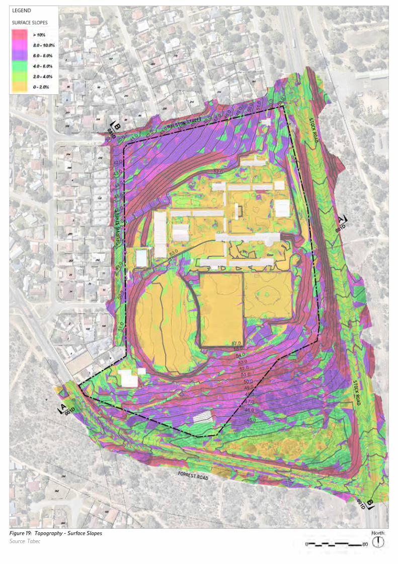
Figure 19: Topography - Surface SlopesSource: Tabec

4.2.4 NATURAL ENVIRONMENTA Flora and Fauna survey was undertaken on the site in 2016 by PGV Environmental (refer to Appendix E). Five native vegetation types were recorded in the southern part of the site. The vegetation types included woodlands of Jarrah and Banksia (Banksia attenuata and B. menziesii), Marri woodlands and some Tuart trees. Heathlands occurred in disturbed areas including in the power line easement. Most of the native vegetation was considered to be in Good or Degraded condition due to the high density of invasive weeds such as Veldtgrass, Lupins, Wild Oats, Oxalis, Couch and Victorian Teatree.
A total of 87 plant species were recorded during the 2016 flora survey consisting of 56 native species and 31 (36%) introduced species. The high percentage of introduced species reflects the degraded nature of some parts of the Site. There were no Threatened (Declared Rare) or Priority species recorded on the site. The planted trees and shrubs on the school grounds provide habitat for some species of birds, however overall the school site has low values as a fauna habitat. The native vegetation in the southern part of the site has the highest habitat values as it has retained some trees and native understorey, although the small size and low quality of a large amount of this area would limit the use of the site to birds, reptiles and invertebrates.
The existing Site has 229 identified trees, with a total of 16% existing tree canopy coverage. Ten species occur on the Site that could be used by Black Cockatoos for foraging, roosting or future breeding habitat. Carnaby’s Black Cockatoos and Forest Red-tailed Black Cockatoos are listed under State and Commonwealth Legislation as Threatened species as such retention of relevant trees is important. As highlighted in the ‘Flora, Vegetation and Black Cockatoo Habitat Survey’ completed by PGV Environmental in January 2017, there are 27 trees within the site, primarily within the southern bushland area, that have the potential to be Cockatoo Habitat Trees, these are highlighted on Figure 20.
4.2.5 LANDSCAPEHSHS is a conventional educational landscape with large grassed playing fields, a swimming pool, carparking, fenced tennis and basketball courts and a number of smaller paved communal areas, typically referred to as ‘quadrangles’ immediately adjacent the school buildings. Built in the 1960’s, the schools’ hard landscape elements; retaining walls, footpaths, stairs and ramps, embrace the use of concrete, red brick, breeze blocks symbolic of the modernist era. There may be opportunities to reuse some of these materials as features in the new landscape design. A detailed survey of useful salvage will be undertaken as part of the design process. Garden beds throughout the school are also reflective of this era, with popular tree and shrub species incorporated including Hibiscus, Ficus, Poinsettia, Acalypha, Meterosiderous, Callistemon and Phoenix to name a few.
In the southern portion of the site a 133kV power line easement runs east-west separating the school playing fields with a 2.7 ha area of existing Banksia bushland. This pocket of bushland forms part of a larger green corridor associated with the previously planned Roe 8 road extension and plays an important role in connecting local ecosystems.
4.2.6 GROUND CONDITIONSGeology mapping for the area indicates the elevated areas of the Site consists of Tamala limestone and Safety Bay sands with other areas on site containing sand derived from Tamala limestone. To confirm the ground conditions a geotechnical investigation was carried out in July 2017 by Douglas Partners geotechnical engineers.
The ground conditions include topsoil up to depths of 150mm. The area south of the Western Power transmission line includes topsoil up to 250mm depths. Douglas Partners have identified that the sandy portion of stripped topsoil is able to be blended with clean sand for re-use onsite as structural fill. Underlying the topsoil, there is medium-dense to dense sand which is fine to medium grained with traces of silt. Loose sand however was encountered and this was predominantly in the south-west of the site. Loose sand was found up to depths of approximately 8m below existing surface elevations which may require additional works during the earthworks program to over-excavate and compact the loose material in order to adequately prepare the site for residential subdivision purposes. It is confirmed the sand material onsite is suitable for re-use as structural fill provided the site preparation requirements are completed.
HAMILTON SENIOR HIGH SCHOOL - LOCAL STRUCTURE PLAN60

Figure 20: Existing Landscape Conditions

HAMILTON SENIOR HIGH SCHOOL - LOCAL STRUCTURE PLAN62
4.3 Servicing
Figure 21 illustrates the existing servicing capacity for the Site.
4.3.1 POWERThere is an existing Western Power 132kV Transmission Line Dual Circuit traversing the Site. Western Power has confirmed that an easement of 28m in total width, being 14m either side of the structure centre line is necessary. There is a restricted zone for proposed development in proximity to the transmission line which is 12.5m horizontally either side of the easement centre line.
There is one existing Transmission Line tower located toward the eastern portion of the Western Power easement and a protection zone around the existing footings exists. Levels are not able to be modified within this zone. There is another tower at the western end of the power easement, on the boundary of the Forrest Road reserve. Similarly, protection zones around the existing footings will apply. On other site boundaries, there is existing underground power on the northern side of Ralston Street and the western side of Purvis Street with power crossings to the school side where appropriate.
4.3.2 COMMUNICATIONSNBNCO is responsible for the installation of fibre in all broad acre developments over 100 dwellings. The Site has been identified by NBNCO as currently being within the rollout map with services available to surrounding areas. In order for NBNCO to rollout fibre services to the project, a developer agreement will be necessary prior to any construction works commencing. In addition to the NBN services, it is noted there is an existing Optus major optic fibre cable in the southern verge of Ralston Street. This existing asset will require adequate protection during civil works.
4.3.3 GASThere is an existing DN100PVC medium pressure gas pipeline on the western side of Purvis Street and a DN110PE medium pressure gas pipeline on the northern side of Ralston Street. There is an existing 225PE high pressure gas line in O’Connell Street which is to the west of the Site. There are no existing ATCO gas assets on the southern or eastern boundaries in Forrest Road or Stock Road respectively. ATCO Gas has advised that on the 2018 forecasted model in severe winter conditions, the loading within the vicinity of the site is at 60% capacity.
4.3.4 WATERThere is an existing DN610 RC water main in the southern verge of Ralston Street on an approximately 3.5m alignment. On the northern side of Ralston Street is a DN100 RC water main which also connects to a larger water main which runs under Stock Road being a DN205 steel main. From the existing DN100 water main in Ralston Street, two 100mm diameter connections to the Site currently exist. There is also an existing DN100 water main along the western side of Purvis Street servicing existing homes fronting this road, however, it does not appear there are any connections to the Site School.
On an approximate 4.4m alignment inside the eastern boundary of the Hamilton Senior High School site is an existing DN760 steel water main that runs adjacent to Stock Road. There are two large air valves with concrete surface structures where mains connect in the north east portion of the site. It appears this main was constructed in 1956 and therefore, due to the age of these existing assets, accurate as-constructed records do not exist and additional survey to confirm the alignments and depths should be undertaken.
4.3.5 WASTEWATERThe Water Corporation has existing scheme planning that covers the project area and advises that the site can be serviced through the extension of a gravity sewer network. The Site falls within the catchment of the existing waste water pump station ‘PS17’ on Halstead Street which is approximately 215m north of the site. The surrounding residential developments are serviced with reticulated sewer and due to the steep topography of the area; easements with gravity sewer connections in the rear of existing properties are common.
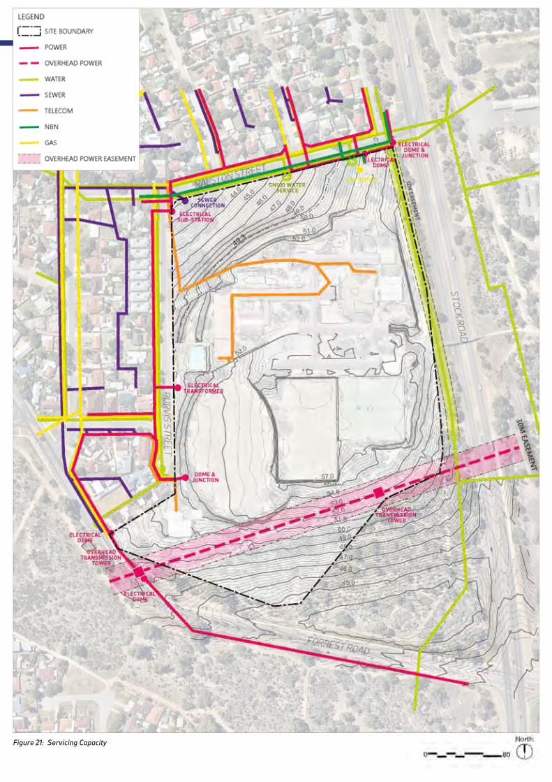
Figure 21: Servicing Capacity

HAMILTON SENIOR HIGH SCHOOL - LOCAL STRUCTURE PLAN64
Figure 22: Opportunities
+ Potential views of Fremantle Harbour, Rottnest Island, Indian Ocean, Garden Island and Darling Escarpment. There is an opportunity to enjoy the views through a number of public areas;
+ Significant green canopy to link a number of open spaces;
+ Maintain access to bus services where possible;
+ Retain links across Stock Road through existing pedestrian bridge;
+ Opportunity to link the site to wider cycle networks;
+ Retain numerous mature trees through the site to enhance green links; and
+ Promote active and healthy communities through cycle and pedestrian connectivity.
4.4.1 OPPORTUNITIES
4.4 Opportunities and Challenges

SITE ANALYSIS NOVEMBER 201965
+ Age, presence of hazardous materials and condition of school buildings makes them unsuitable for re-use;
+ Steep slope along northern and western edges;
+ High Voltage power easement (28m);
+ Water main easement along eastern boundary (12m);
+ Bushfire buffers to eastern and western boundary;
+ New development needs to work with existing drainage points;
+ Sound-wall required on Stock Road; and
+ No local shops or services within 400m walking catchment.
Figure 23: Challenges
4.4.2 CHALLENGES


5.0 CONCEPT DESIGN
+ 5.1 Design Principles
+ 5.2 Design Layers

5.1 Design Principles
HILLSIDE TOWNUrban form that responds to the drama of topography and views.
+ Steep areas - larger dwellings
+ Flat areas - small lots
+ Split level sites
+ Balance cut and fill
+ Typologies designed for sloping sites
CONNECTED LANDSCAPE ‘STRING OF PEARLS’Provide a cohesive and manageable open space network.
+ Maintain significant trees
+ Improve the tree canopy cover
+ The ‘third place’
+ Inviting the neighbours to experience and enjoy
+ Access to open space from front of homes
PEDESTRIAN AND CYCLE LINKAGESStrengthening desire lines, nodal activation and linkages through to Stock Road Bridge.
+ Perth Bicycle Network (PBN) linking through development
+ Promote cycling for everyone, enable casual cycling
+ Active and healthy community
SENSE OF ARRIVAL AND JOURNEYLinking views and vistas from public and private places.
+ Defined gateway
+ Distinctive character
+ Delight and intrigue
+ Experience of place
+ Vistas towards the site
+ Integrate built edge and landscape
HAMILTON SENIOR HIGH SCHOOL - LOCAL STRUCTURE PLAN68

A NEIGHBOURLY EDGEBlur edges by integrating the suburban edge, with the street and amenity.
+ Building scale
+ Safety and surveillance
+ Strengthen community
+ Amenity of adjoining neighbours
+ Outlook to public places
CLIMATE RESPONSIVE URBAN FORMRespond to local micro-climate.
+ Green canopies reduce urban heat island effect
+ Solar access in summer and winter
+ Breeze paths
+ Orientation to maximise usable space
+ Minimise road crossings within site
DIVERSITY OF LIFESTYLE OPPORTUNITIESOffering diverse lot sizes, dwellings types, and arrangements.
+ Multi-generational housing
+ Ancillary uses
+ Adaptability
+ Shared housing
+ Shared developments
+ Different price points
A COMMUNITY HUB THAT INVITES LOCALS INCommunity hub, nature, location and co-location of open space.
+ Legible connections
+ Connected to open space
+ Suitability for location
+ Easily accessible
CONCEPT DESIGN NOVEMBER 201969

5.2 Design Layers
SITE CHARACTERThe site is situated on a hill overlooking the suburb of Hamilton Hill and beyond to the Indian Ocean. The topography enables extensive views from many locations on the site and a hillside edge is clearly evident as a contour running through the site.
There are numerous mature trees on the site and the school campus layout offers a rectilinear formality with buildings located along a north- south circulation spine.
The key character elements underlying the concept plan are:
+ Retention of trees
+ Hillside edge
+ School memory (spine)
+ Views
LANDSCAPE CORRIDORSA hierarchy of open spaces has been set up that prioritises retention of trees and permeability and connectivity across the site. The primary landscape connections are the east- west connection that references an indigenous Bidi track as well as a desire line to the Stock Road pedestrian bridge and the north south alignment of the hillside edge contour with its terraced topography and trees.
HAMILTON SENIOR HIGH SCHOOL - LOCAL STRUCTURE PLAN70

TERRAINIn addition to careful design of the cut and fill for the development, the terrain has been used to create outlook to landscape corridors and views. Higher density housing on small lots is located on the flatter parts of the site while group housing is located where building form can be used to accommodate level changes.
MOVEMENTThe hierarchy of landscape spaces combined with the school spine provide the basis of the pedestrian movement network within the site and connections out to the suburb and over the Stock Road bridge. The’ Bidi track’ memory of indigenous connections strengthens the rationale for the east-west connection while the north south connections lead through to the open space in the south of the site.
Pedestrian movement is provided for both along streets and through the open space network with an intent to encourage active lifestyles and reduce car dependency.
CONCEPT DESIGN NOVEMBER 201971

NEIGHBOURING EDGEAn important design layer is the response to the surrounding residential suburb and the quality of the development edge. Wider lots are located to the frontages of Purvis and Ralston Streets reflecting the existing urban pattern.
Placement of connections into the site considers the permeability and alignment of the urban grid while celebrating the hillside as a distinct urban element that is treated differently in response to the terrain.
HILLTOPAbove the hillside contour the street pattern responds primarily to the school spine and rectilinear grid while capturing views from both the public domain and private homes, preserving buffers required to the east and optimising access and outlook to open spaces.
HAMILTON SENIOR HIGH SCHOOL - LOCAL STRUCTURE PLAN72
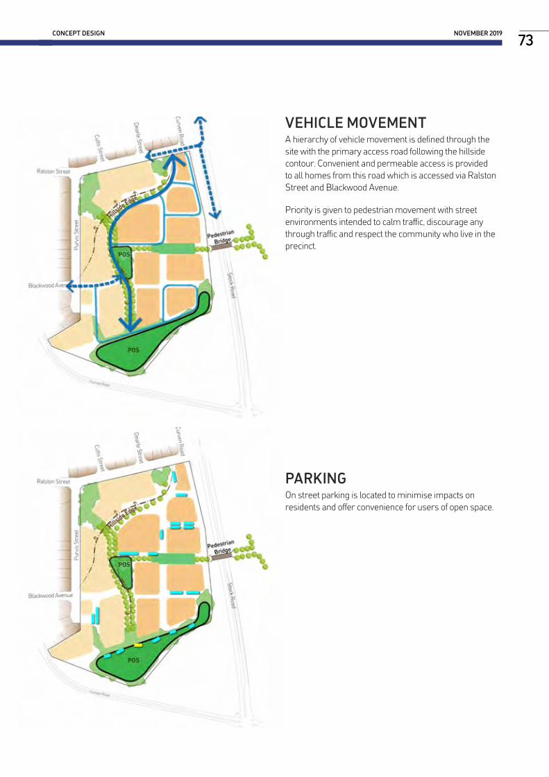
VEHICLE MOVEMENTA hierarchy of vehicle movement is defined through the site with the primary access road following the hillside contour. Convenient and permeable access is provided to all homes from this road which is accessed via Ralston Street and Blackwood Avenue.
Priority is given to pedestrian movement with street environments intended to calm traffic, discourage any through traffic and respect the community who live in the precinct.
PARKINGOn street parking is located to minimise impacts on residents and offer convenience for users of open space.
CONCEPT DESIGN NOVEMBER 201973

6.0 THE STRUCTURE PLAN
+ 6.1 Land Use and Urban Form
+ 6.2 Movement and Access
+ 6.3 Landscape
+ 6.4 Environment
+ 6.5 Engineering and Servicing

6.1 Land Use and Urban Form
6.1.1 LAND USEMIXED-USETwo mixed use sites are proposed within the HLSP. The two sites provide opportunity for a level of amenity currently not available to residents in Hamilton Hill. The potential mixed use site on Purvis Street (Superlot 11) will likely accommodate a small convenience store, providing small scale retail within the 400m walkable catchment of the Site. The benefit of this location is that it can capitalise on the embayed parking already provided on Purvis Street.
The second mixed use site is envisaged within Group Site 3 (Superlot 14) and would likely provide a cafe, co-located with the central POS site, to provide residents with a local meeting place that fosters social interaction.
RESIDENTIALAs illustrated on “Figure 1: Structure Plan Map”, the primary land use incorporated within the HLSP is residential. The HLSP is comprised of 14 superlots, each of which has been assigned either R40, R60 or R80 residential densities. This range of residential densities is proposed to support a variety of housing and lot typologies. Section “6.1.3 Built Form Character” provides guidance on the design intent and preferred character of these typologies.
YIELD ANALYSISFigure 24 illustrates how the Site could be developed based on the HLSP. The proposed development yields, are summarised in Table 9.
Table 9: Yield Analysis
Total Site Area 11.91 HAPAW 0.04 HA (<1% Coverage)POS (incl. south) 2.02 HA (16.9% Coverage)Road Reserve 3.77 HA (31.7% Coverage)Total 5.67 HA
Lot Mix
Lot Type Lots Dwellings AreaCorner Lots 32 32 0.95 HALarge Individual Lots 66 68 2.72 HATerrace / Small Lots 137 135 1.73 HAGroup Dwellings 4 77* 1.04 HATotal Development Area 239 312 6.44 HA
*Grouped Sites Dwelling Yield
Site QTY @ (R80) AreaGroup Site 1 29 0.35 HAGroup Site 2 22 0.27 HAGroup Site 3 7 0.09 HAGroup Site 4 19 0.33 HATotal Dwellings 77 1.04 HA
ESTIMATED POPULATIONBased on an average household size of 2.6 persons, the HLSP has potential to cater for a population of approximately 800 people.
HAMILTON SENIOR HIGH SCHOOL - LOCAL STRUCTURE PLAN76

THE STRUCTURE PLAN NOVEMBER 201977
RALSTON STREET
STOCK RO
AD
FORREST ROAD
PURV
IS S
TREE
T
BLACKWOOD AVENUE
Pedestrian Bridge
Group Site 2
Group Site 1
Group Site 4
Group Site 3
HLSP BoundaryHLSP Lot BoundariesIndicative Lot Boundaries
Large Individual Lot
Terrace Lot
Corner Lot
Grouped Site
Public Open Space
Public Access Way
Tree for Retention
Mixed-Use Site
LEGEND
LOT DESIGN TO BE RESOLVED
© Hames Sharley
North: Project Number:Revision:Date:
Scale:
HAMILTON SENIOR HIGH SCHOOL REDEVELOPMENTConcept Plan 1:1000 @ A1 43711
B23/10/20190 80
WESTERN POWER EASEMENT
Figure 24: Concept Plan

6.1.2 URBAN FORMHEIGHTSBuilding heights within the HLSP are proposed to be in accordance with the R-Codes. R40 lots are deliberately located opposite existing residential areas to provide a coherent streetscape and enable the creation of split-level lots (on the larger lots).
The design response seeks to take advantage of the topography by optimising opportunities for views. Grouped Housing Sites 2 and 3 in particular are located in the highest points of the Site to maximise opportunities for coastal views. Grouped Housing Sites have the potential to be 3-4 storeys, however, it is likely that 3 storeys would be preferred to minimise the requirements for lifts (reducing potential development costs).
SETBACKSSetbacks to lots will vary throughout the HLSP (these will be specified in Local Development Plans). Setbacks in R40 areas will provide a deeper setback in keeping with the surrounding built form. Setbacks in R60 areas will be minimised to enable greater interaction between the built form with the streetscape and public open space areas.
TOPOGRAPHYThe HLSP design response has treated the natural topography as an opportunity rather than a challenge. The slope has enabled opportunities for views to both the coastline and the Darling Escarpment.
The proposed housing typologies deal with existing levels as appropriate, enabling houses to utilise site levels to their advantage.
Figure 25 illustrates indicative site sections which demonstrate the design response to the site’s topography.
RALSTON STREET
STOCK RO
AD
FORREST ROAD
PURV
IS S
TREE
T
BLACKWOOD AVENUE
Pedestrian Bridge
Group Site 2
Group Site 1
Group Site 4
Group Site 3
HLSP BoundaryHLSP Lot BoundariesIndicative Lot Boundaries
Large Individual Lot
Terrace Lot
Corner Lot
Grouped Site
Public Open Space
Public Access Way
Tree for Retention
Mixed-Use Site
LEGEND
LOT DESIGN TO BE RESOLVED
© Hames Sharley
North: Project Number:Revision:Date:
Scale:
HAMILTON SENIOR HIGH SCHOOL REDEVELOPMENTConcept Plan 1:1000 @ A1 43711
B23/10/20190 80
WESTERN POWER EASEMENT
B
A
Figure 25: Sections
SECTION A
SECTION B
30m DEEP LOTS 30m DEEP LOTS
30m DEEP LOTS 30m DEEP LOTS
HAMILTON SENIOR HIGH SCHOOL - LOCAL STRUCTURE PLAN78

6.1.3 BUILT FORM CHARACTERThe HLSP promotes a diverse built form character that supports a range of residential densities and typologies. The desired character is outlined below.
RESIDENTIAL R40In areas zoned R40 proposed lots will range from 250m2 to 580m2. As described in Section “5.2 Design Layers” these lots have been deliberately located adjacent to existing residential areas on Purvis and Ralston Streets to reflect the existing residential character. These lots are primarily 30m x 10m and can accommodate separate detached houses which are the most common dwelling type currently found throughout Hamilton Hill.
Desired Built Form Character R40 Areas
THE STRUCTURE PLAN NOVEMBER 201979

RESIDENTIAL R60In areas zoned R60 a variety of lot and dwelling types are proposed. They typically range from 150m2 to 175m2 dependent on lot depth. These lots are longer and narrower which provide opportunities for semi-detached dwelling typologies, such as terrace, row or townhouse developments. The majority of lots are either 29m x 6m, 25m x 6m or 20m x 8m (indicative floor plans are provided below).
Housing typologies consider the existing residential neighbourhood character and focus on optimising liveability. Through the use of laneways these typologies provide opportunities for homes to obtain direct frontage to landscape corridors and open spaces. View of garages are limited from the street, and generous tree planting will optimise the visual quality of internal streets. Directing cars to laneways gives the streets back to pedestrians, promoting active transport and healthy lifestyles. The proposed lot/dwelling typologies also consider the needs of the diverse demographic in the area. Certain lots provide opportunities for ageing in place, by enabling the ground floor of terrace homes to accommodate bedrooms. This is attractive to older residents who have reduced mobility.
All typologies seek to enable an appropriate environmental response. Private open space and courtyards should capitalise on environmental conditions by allowing good cross ventilation and access to natural daylight, this minimises potential operating costs of homes. These lots enable the house design to achieve Liveable Housing Australia silver status to promote ageing in place.
Desired Built Form Character R60 Areas
HAMILTON SENIOR HIGH SCHOOL - LOCAL STRUCTURE PLAN80

GROUND LEVEL UPPER LEVEL
29M X 6M LOTS
GROUND LEVEL UPPER LEVEL
25M X 6M LOTS
GROUND LEVEL UPPER LEVEL GROUND LEVEL UPPER LEVEL
OPTION 1 OPTION 2
THE STRUCTURE PLAN NOVEMBER 201981
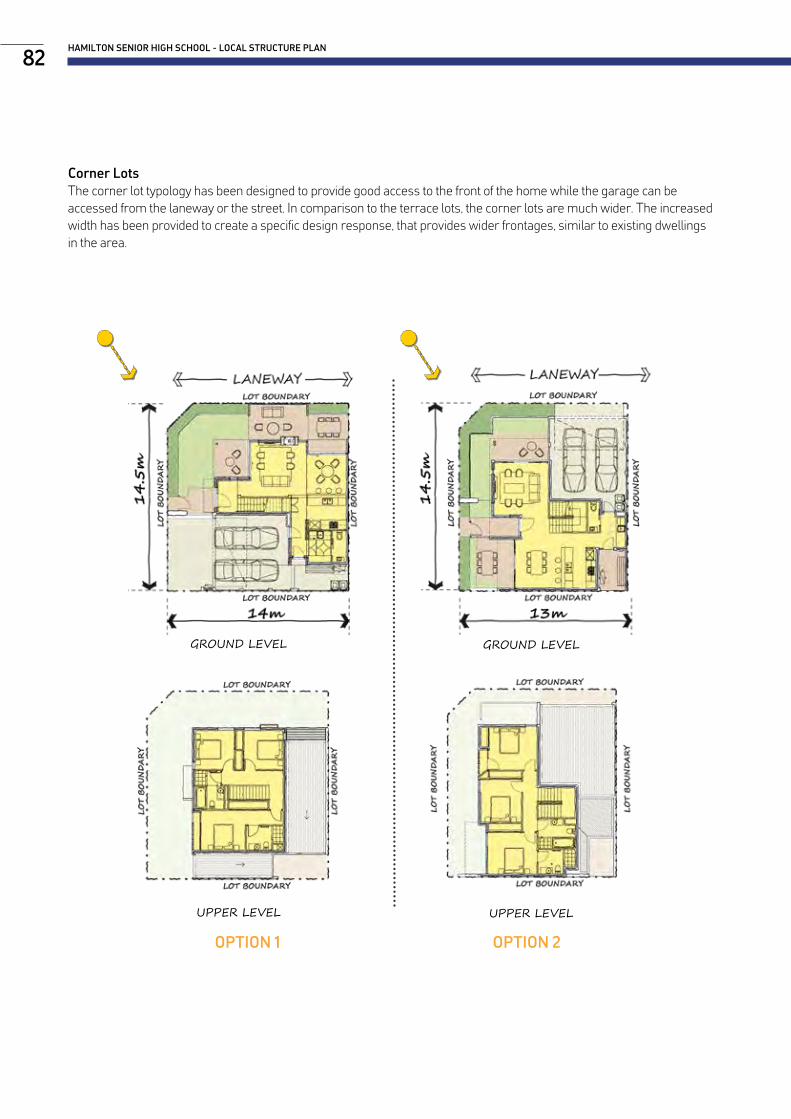
GROUND LEVEL
UPPER LEVEL
GROUND LEVEL
UPPER LEVEL
Corner LotsThe corner lot typology has been designed to provide good access to the front of the home while the garage can be accessed from the laneway or the street. In comparison to the terrace lots, the corner lots are much wider. The increased width has been provided to create a specific design response, that provides wider frontages, similar to existing dwellings in the area.
OPTION 1 OPTION 2
HAMILTON SENIOR HIGH SCHOOL - LOCAL STRUCTURE PLAN82

RESIDENTIAL R80Grouped housing sites have been specifically located to capitalise on surrounding views. They also provide a higher density urban form and character, promoting choice and diversity within the HLSP. Each grouped housing site provides flexibility with regard to built form type, character, yield and access.
Group Housing Site 3 provides for a small scale retail offering (likely to be a cafe). This will both add value to the HLSP area by providing localised amenity, and address the current shortfall of retail in the surrounding area.
Desired Built Form Character R80 Areas
THE STRUCTURE PLAN NOVEMBER 201983
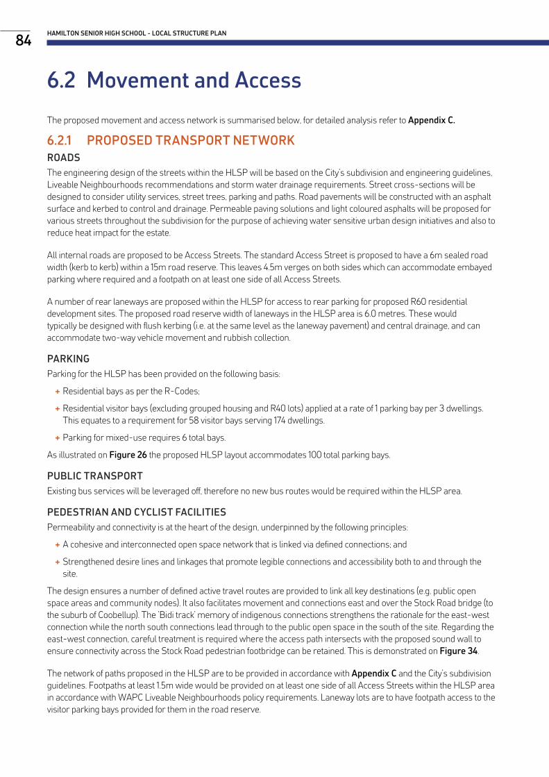
6.2 Movement and Access
The proposed movement and access network is summarised below, for detailed analysis refer to Appendix C.
6.2.1 PROPOSED TRANSPORT NETWORKROADSThe engineering design of the streets within the HLSP will be based on the City’s subdivision and engineering guidelines, Liveable Neighbourhoods recommendations and storm water drainage requirements. Street cross-sections will be designed to consider utility services, street trees, parking and paths. Road pavements will be constructed with an asphalt surface and kerbed to control and drainage. Permeable paving solutions and light coloured asphalts will be proposed for various streets throughout the subdivision for the purpose of achieving water sensitive urban design initiatives and also to reduce heat impact for the estate.
All internal roads are proposed to be Access Streets. The standard Access Street is proposed to have a 6m sealed road width (kerb to kerb) within a 15m road reserve. This leaves 4.5m verges on both sides which can accommodate embayed parking where required and a footpath on at least one side of all Access Streets.
A number of rear laneways are proposed within the HLSP for access to rear parking for proposed R60 residential development sites. The proposed road reserve width of laneways in the HLSP area is 6.0 metres. These would typically be designed with flush kerbing (i.e. at the same level as the laneway pavement) and central drainage, and can accommodate two-way vehicle movement and rubbish collection.
PARKINGParking for the HLSP has been provided on the following basis:
+ Residential bays as per the R-Codes;
+ Residential visitor bays (excluding grouped housing and R40 lots) applied at a rate of 1 parking bay per 3 dwellings. This equates to a requirement for 58 visitor bays serving 174 dwellings.
+ Parking for mixed-use requires 6 total bays.
As illustrated on Figure 26 the proposed HLSP layout accommodates 100 total parking bays.
PUBLIC TRANSPORTExisting bus services will be leveraged off, therefore no new bus routes would be required within the HLSP area.
PEDESTRIAN AND CYCLIST FACILITIESPermeability and connectivity is at the heart of the design, underpinned by the following principles:
+ A cohesive and interconnected open space network that is linked via defined connections; and
+ Strengthened desire lines and linkages that promote legible connections and accessibility both to and through the site.
The design ensures a number of defined active travel routes are provided to link all key destinations (e.g. public open space areas and community nodes). It also facilitates movement and connections east and over the Stock Road bridge (to the suburb of Coobellup). The ’Bidi track’ memory of indigenous connections strengthens the rationale for the east-west connection while the north south connections lead through to the public open space in the south of the site. Regarding the east-west connection, careful treatment is required where the access path intersects with the proposed sound wall to ensure connectivity across the Stock Road pedestrian footbridge can be retained. This is demonstrated on Figure 34.
The network of paths proposed in the HLSP are to be provided in accordance with Appendix C and the City’s subdivision guidelines. Footpaths at least 1.5m wide would be provided on at least one side of all Access Streets within the HLSP area in accordance with WAPC Liveable Neighbourhoods policy requirements. Laneway lots are to have footpath access to the visitor parking bays provided for them in the road reserve.
HAMILTON SENIOR HIGH SCHOOL - LOCAL STRUCTURE PLAN84
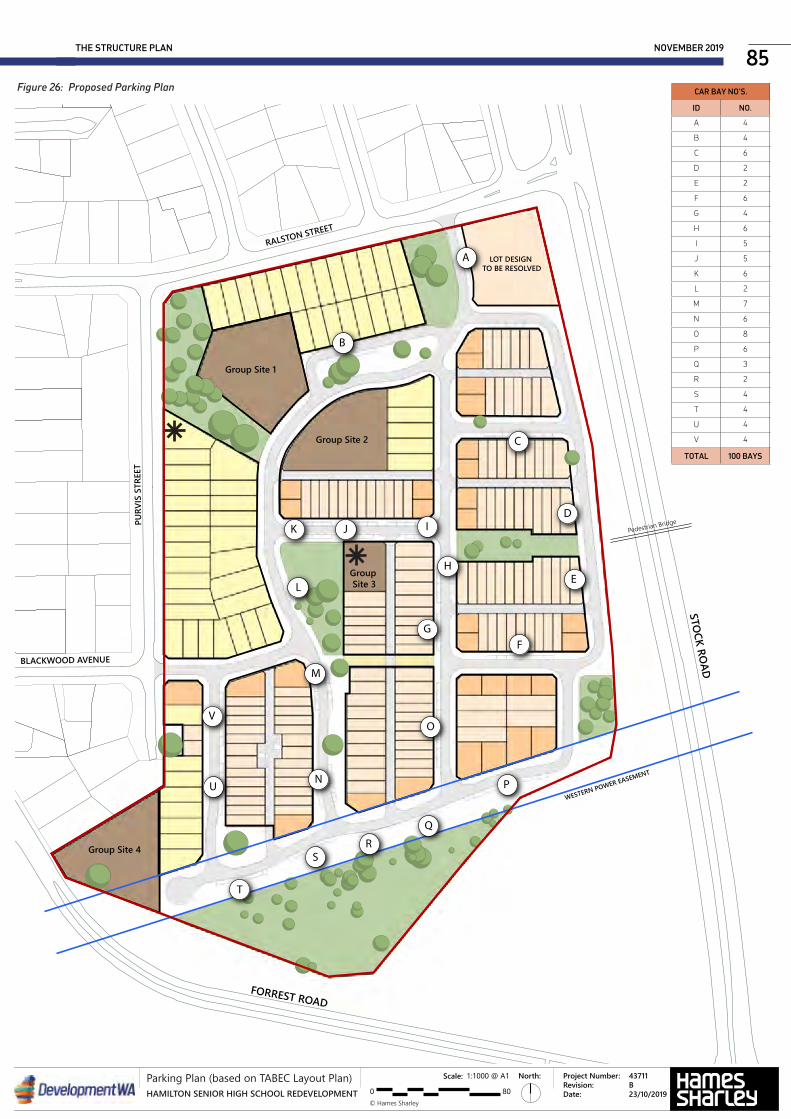
THE STRUCTURE PLAN NOVEMBER 201985
RALSTON STREET
STOCK RO
AD
FORREST ROAD
PURV
IS S
TREE
T
BLACKWOOD AVENUE
Pedestrian Bridge
Group Site 2
Group Site 1
Group Site 4
Group Site 3
HLSP BoundaryHLSP Lot BoundariesIndicative Lot Boundaries
Large Individual Lot
Terrace Lot
Corner Lot
Grouped Site
Public Open Space
Public Access Way
Tree for Retention
Mixed-Use Site
LEGEND
LOT DESIGN TO BE RESOLVED
© Hames Sharley
North: Project Number:Revision:Date:
Scale:
HAMILTON SENIOR HIGH SCHOOL REDEVELOPMENTConcept Plan 1:1000 @ A1 43711
B23/10/20190 80
WESTERN POWER EASEMENT
A
B
E
JK
L
M
N
H
I
P
Q
O
R
V
S
T
U
D
C
FG
© Hames Sharley
North: Project Number:Revision:Date:
Scale:
HAMILTON SENIOR HIGH SCHOOL REDEVELOPMENTParking Plan (based on TABEC Layout Plan) 1:1000 @ A1 43711
B23/10/20190 80
Figure 26: Proposed Parking Plan CAR BAY NO’S.
ID NO.
A 4
B 4
C 6
D 2
E 2
F 6
G 4
H 6
I 5
J 5
K 6
L 2
M 7
N 6
O 8
P 6
Q 3
R 2
S 4
T 4
U 4
V 4
TOTAL 100 BAYS
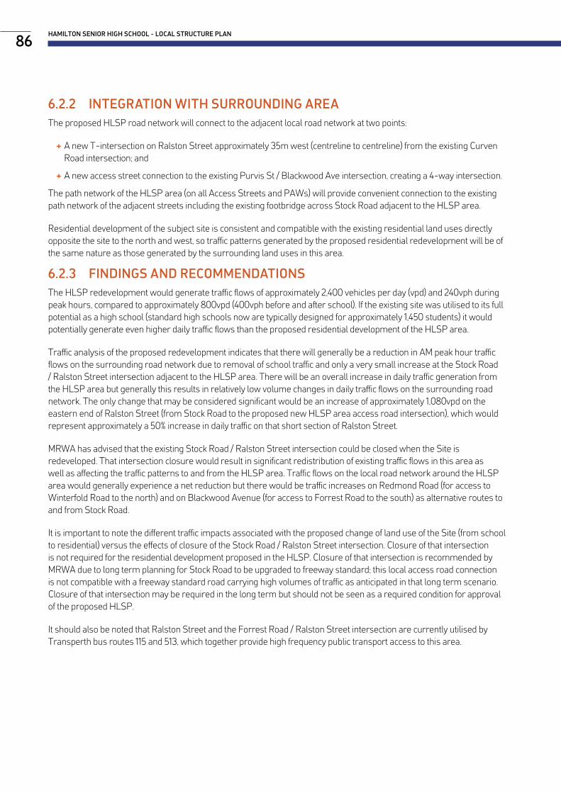
6.2.2 INTEGRATION WITH SURROUNDING AREAThe proposed HLSP road network will connect to the adjacent local road network at two points:
+ A new T-intersection on Ralston Street approximately 35m west (centreline to centreline) from the existing Curven Road intersection; and
+ A new access street connection to the existing Purvis St / Blackwood Ave intersection, creating a 4-way intersection.
The path network of the HLSP area (on all Access Streets and PAWs) will provide convenient connection to the existing path network of the adjacent streets including the existing footbridge across Stock Road adjacent to the HLSP area.
Residential development of the subject site is consistent and compatible with the existing residential land uses directly opposite the site to the north and west, so traffic patterns generated by the proposed residential redevelopment will be of the same nature as those generated by the surrounding land uses in this area.
6.2.3 FINDINGS AND RECOMMENDATIONSThe HLSP redevelopment would generate traffic flows of approximately 2,400 vehicles per day (vpd) and 240vph during peak hours, compared to approximately 800vpd (400vph before and after school). If the existing site was utilised to its full potential as a high school (standard high schools now are typically designed for approximately 1,450 students) it would potentially generate even higher daily traffic flows than the proposed residential development of the HLSP area.
Traffic analysis of the proposed redevelopment indicates that there will generally be a reduction in AM peak hour traffic flows on the surrounding road network due to removal of school traffic and only a very small increase at the Stock Road / Ralston Street intersection adjacent to the HLSP area. There will be an overall increase in daily traffic generation from the HLSP area but generally this results in relatively low volume changes in daily traffic flows on the surrounding road network. The only change that may be considered significant would be an increase of approximately 1,080vpd on the eastern end of Ralston Street (from Stock Road to the proposed new HLSP area access road intersection), which would represent approximately a 50% increase in daily traffic on that short section of Ralston Street.
MRWA has advised that the existing Stock Road / Ralston Street intersection could be closed when the Site is redeveloped. That intersection closure would result in significant redistribution of existing traffic flows in this area as well as affecting the traffic patterns to and from the HLSP area. Traffic flows on the local road network around the HLSP area would generally experience a net reduction but there would be traffic increases on Redmond Road (for access to Winterfold Road to the north) and on Blackwood Avenue (for access to Forrest Road to the south) as alternative routes to and from Stock Road.
It is important to note the different traffic impacts associated with the proposed change of land use of the Site (from school to residential) versus the effects of closure of the Stock Road / Ralston Street intersection. Closure of that intersection is not required for the residential development proposed in the HLSP. Closure of that intersection is recommended by MRWA due to long term planning for Stock Road to be upgraded to freeway standard; this local access road connection is not compatible with a freeway standard road carrying high volumes of traffic as anticipated in that long term scenario. Closure of that intersection may be required in the long term but should not be seen as a required condition for approval of the proposed HLSP.
It should also be noted that Ralston Street and the Forrest Road / Ralston Street intersection are currently utilised by Transperth bus routes 115 and 513, which together provide high frequency public transport access to this area.
HAMILTON SENIOR HIGH SCHOOL - LOCAL STRUCTURE PLAN86

THE STRUCTURE PLAN NOVEMBER 201987

6.3.1 PHILOSOPHYThe landscape design intent for the HLSP is to create an attractive and innovative network of green spaces, which provide a range of functions and amenities for the local community. The site will feature approximately 2.3 hectares of public open space, inclusive of a Nature Based Open Space, Neighbourhood Parks and Green Nodes. The connections between these nodes will be important, with roads acting as legitimate public domain. There will be an emphasis on developing green corridors across the development, including green public access ways and verges.
The Site will integrate with the surrounding suburban tapestry, by creating new opportunities for community interaction and strengthen existing pedestrian and bicycle connections. It also aims to capture and enhance Hamilton Hill’s unique character, as well as the history of HSHS, which currently operates on the Site.
The project will target EnviroDevelopment accreditation under all six elements of the framework: Ecosystems, Waste, Materials, Energy, Water and Community. In order to achieve this, the landscape design will aim to utilise climate response design principles and incorporate best practice water and energy efficient initiatives. It will reduce urban heat island effects through increased tree canopy coverage, and careful selection of products and materials.
Crime Prevention Through Environmental Design (CPTED) principles have informed the landscape concept design as part of developing a healthy, safe environment.
6.3.2 LANDSCAPE TYPOLOGIESFigure 27 illustrates the public open space distribution for the HLSP, a further breakdown with a schedule of areas is provided in Table 10.
Table 10: Public Open Space Schedule
Total Net Site Area 11.91 ha
Deductions 0.84 ha
Transmission Corridors 8,382 m2
Gross Subdivisible Area 11.07 ha
Unrestricted POS No. 2.02 ha
1 1,552 m2
2 3,391 m2
3 2,144 m2
4 1,467 m2
5 11,612 m2 *
*Includes: 600m2 of amenity and paving, 1,300m2 nature play, 1,600m2 kickabout/drainage and 8,112 m2 existing bush and revegetation.
As shown on Figure 28, there are four distinct landscape typologies which comprise public open space areas within the HLSP area, these are:
+ Nature Based Open Space;
+ Neighbourhood Parks;
+ Green Nodes; and
+ Green Access Ways.
Further detail on these landscape typologies is provided below.
6.3 Landscape Public Realm
HAMILTON SENIOR HIGH SCHOOL - LOCAL STRUCTURE PLAN88

THE STRUCTURE PLAN NOVEMBER 201989
RALSTON STREET
STOCK RO
AD
FORREST ROAD
PURV
IS S
TREE
T
BLACKWOOD AVENUE
Pedestrian Bridge
Group Site 2
Group Site 1
Group Site 4
Group Site 3
HLSP BoundaryHLSP Lot BoundariesIndicative Lot Boundaries
Large Individual Lot
Terrace Lot
Corner Lot
Grouped Site
Public Open Space
Public Access Way
Tree for Retention
Mixed-Use Site
LEGEND
LOT DESIGN TO BE RESOLVED
© Hames Sharley
North: Project Number:Revision:Date:
Scale:
HAMILTON SENIOR HIGH SCHOOL REDEVELOPMENTConcept Plan 1:1000 @ A1 43711
B23/10/20190 80
WESTERN POWER EASEMENT
1
2
3
4
5
5
© Hames Sharley
North: Project Number:Revision:Date:
Scale:
HAMILTON SENIOR HIGH SCHOOL REDEVELOPMENTPublic Open Space Schedule 1:1000 @ A1 43711
A01/11/20190 80
Figure 27: Public Open Space Distribution

NATURE BASED OPEN SPACE The Nature Based Open Space will be the largest of the landscape typologies taking up approximately 1.4ha with the majority set aside as retained Banksia woodland. This woodland sits directly north of the previously planned Main Roads Roe 8 road extension/bushland reserve, strongly linking into this much larger ecological bushland reserve creating an excellent habitat corridor and opportunities for bush/dog walking.
In parts where the current bushland is degraded or in poor health, local, native tree and shrub species will be planted with informal walking paths to connect the development to Forrest Road. Requirements around the current Bushfire Regulations and Western Power requirements for the powerline easement will see parts of the existing bushland maintained and managed at a higher level to ensure the safety of locals.
In addition to the existing retained bushland, a range of public amenities will be incorporated to attract a broad demographic of users. Amenities will include a kick-about space, a nature play space and associated facilities, including parkland shelters, BBQ’s, picnic tables, bicycle parking, waste disposal bins and drink fountains.
The play space will be the main feature this public open space, with the layout and custom play elements cleverly complementing the adjacent bushland. The design of this play space will aim to use natural and repurposed materials from the site, where possible.
Vegetated stormwater swales will also be introduced into this area to capture and locally infiltrate storm water from the southern portion of the development.
NEIGHBOURHOOD PARKS There are three Neighbourhood Parks within the Landscape Master Plan - notionally titled the Fig Tree Park, the Peppermint Tree Park and the Central Park. These spaces are smaller than the Nature Based Open Space and therefore designed to cater for a more specific activity and/or demographic.
As its name suggests, Fig Tree Park is located along the northern edge of site amongst a number of significant existing fig trees (Ficus macrophylla). The park is located at the northern vehicular entrance and adjacent to the Ralston Street bus stop therefore making it a great, accessible location to create a statement landscape. This park is proposed to include a second, smaller nature play space as well as BBQ’s, picnic tables, bicycle parking racks and potential artwork.
Similarly, the Peppermint Tree Park is located to retain a stand of mature peppermint trees (Agonis flexuosa), in the north-western corner of site. Due to the number of trees and the area of their associated root protection zones, there will be limited space for active recreational facilities, therefore it is intended that this park will become a passive space with informal seating and paths. A series of vegetated stormwater infiltration swales will also be a key feature in this park that will weave their way between the trees and down the hillside.
Lastly, the Central Park is intended to become the conceptual heart of the development due to its easily accessible central location and range of community focused amenities. This park will look to offer a small kick-about area and informal play area, as well as a public toilet, picnic shelter and BBQ’s. Within the group housing site adjacent, a small cafe is proposed, making this park a convenient meeting spot for locals.
THE QUAD The existing HSHS consists of a series of quadrangles bound by rectangular school classroom blocks. In order to respect this history, one of the quadrangle’s (known as The Quad) has been retained and will be transformed into a small public open space. The Quad, will be regularly trafficked by both pedestrians and cyclists due to its location adjacent to the existing Stock Road pedestrian bridge which connects this development to Coolbellup and beyond. The adjacent residential properties that overlook this space with good passive surveillance will provide a safe environment for its users.
The Quad open space also presents an opportunity to depict the Bidi Track, a historical account of the local Indigenous groups traversing east-west, from the wetlands to the ocean, as the seasons changed. This notion can be communicated
HAMILTON SENIOR HIGH SCHOOL - LOCAL STRUCTURE PLAN90

in the Quad and throughout the development as artwork, as it is likely this site would have been regularly traversed due to its high vantage point offering views of both the ocean and escarpment. This will be further developed with consideration of user experience, functionality and materials.
GREEN NODES Green Nodes are widened road reserves located throughout the development to retain aesthetically valuable trees and/or pick up areas of relatively steep topography. They often play an important role in connecting other larger landscape spaces, however are typically too small to incorporate any significant activity areas or amenities. Most of these nodes will be planted with local tree and shrub species with opportunities for small informal gathering spaces linked by a simple path network. Some of these spaces will also perform a drainage function with vegetated stormwater swales.
GREEN ACCESS WAYS There are three Green Access Ways proposed within the Landscape Master Plan, providing important pedestrian and cycle routes through the development. They offer opportunities for capturing ocean vistas and retaining significant mature trees, as well as one being cleverly aligned to reflect a portion of the existing school’s central north-south corridor axis.
The Green Access Ways will typically have parkland lighting to assist with minimising antisocial behaviour and may incorporate seating, bins and/or cycle racks.
THE STRUCTURE PLAN NOVEMBER 201991
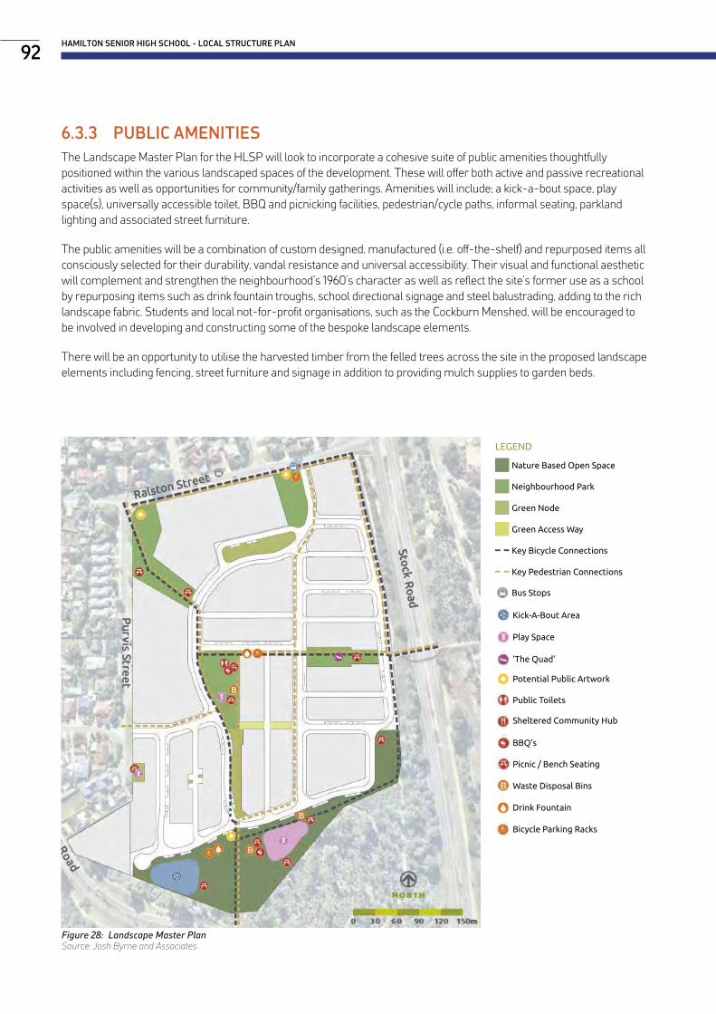
Sheltered Community Hub
Public Toilets
Potential Public Artwork
BBQ’s
Picnic / Bench Seating
Waste Disposal Bins
Drink Fountain
Bicycle Parking Racks
Play Space
Kick-A-Bout Area
‘The Quad’
Nature Based Open Space
Neighbourhood Park
Green Node
Green Access Way
OVERALL TYPOLOGIES & AMENITIES PLAN
NORTH0 15 30 45 60 75m
Key Bicycle Connections
Key Pedestrian Connections
LEGEND
Bus Stops
6.3.3 PUBLIC AMENITIESThe Landscape Master Plan for the HLSP will look to incorporate a cohesive suite of public amenities thoughtfully positioned within the various landscaped spaces of the development. These will offer both active and passive recreational activities as well as opportunities for community/family gatherings. Amenities will include; a kick-a-bout space, play space(s), universally accessible toilet, BBQ and picnicking facilities, pedestrian/cycle paths, informal seating, parkland lighting and associated street furniture.
The public amenities will be a combination of custom designed, manufactured (i.e. off-the-shelf) and repurposed items all consciously selected for their durability, vandal resistance and universal accessibility. Their visual and functional aesthetic will complement and strengthen the neighbourhood’s 1960’s character as well as reflect the site’s former use as a school by repurposing items such as drink fountain troughs, school directional signage and steel balustrading, adding to the rich landscape fabric. Students and local not-for-profit organisations, such as the Cockburn Menshed, will be encouraged to be involved in developing and constructing some of the bespoke landscape elements.
There will be an opportunity to utilise the harvested timber from the felled trees across the site in the proposed landscape elements including fencing, street furniture and signage in addition to providing mulch supplies to garden beds.
HAMILTON SENIOR HIGH SCHOOL - LOCAL STRUCTURE PLAN92
Figure 28: Landscape Master PlanSource: Josh Byrne and Associates

6.3.4 PUBLIC ARTThe public art within the development will look to reflect a number of attributes of the site and adjacent community with a focus on the local Indigenous and European cultural heritage, local flora/fauna and the former school and its history. There may be an opportunity to engage with current HSHS students, teachers and alumni, as well as local art groups in Cockburn and not-for-profit organisations, to develop and create the art pieces.
The public art will aim to embrace a range of mediums including mosaic, metalwork, print, timber carving and utilise locally sourced or repurposed materials that are vandal resistant and durable.
6.3.5 CULTURAL HERITAGE OPPORTUNITIESThere is a rich history within the site and the surrounding Hamilton Hill suburb which will be cleverly woven into the landscape fabric through public art installations, paving treatments material and plant selection. Both the local Indigenous and European communities need to be accurately reflected and represented within the development. Local community groups and individuals are encouraged to assist in the development of these concepts. Opportunities include:
+ Capturing and representing stories from residents, and/or former students and teachers of the school;
+ Incorporating school paraphernalia including signage, drinking troughs, artwork;
+ Depiction of the Bidi Track through the site in different mediums;
+ Encompassing local bush tucker plant species within the development;
+ Incorporating ‘backyard’ European food production with grape vine covered pergolas and olive trees typical in the Hamilton Hill area; and
+ Utilising breeze blocks, columns and other typical European architectural styling elements common throughout the Hamilton Hill area.
For more information refer to the Aboriginal Heritage Survey and Consultation Report prepared by Terra Rosa Consulting (Appendix L).
THE STRUCTURE PLAN NOVEMBER 201993
Bike Parking, Artwork by Sustainable Housing for Artists and Creatives Indigenous Cultural Heritage Example
Bus Stop, Artwork by Stormie Mills European Cultural Heritage Example
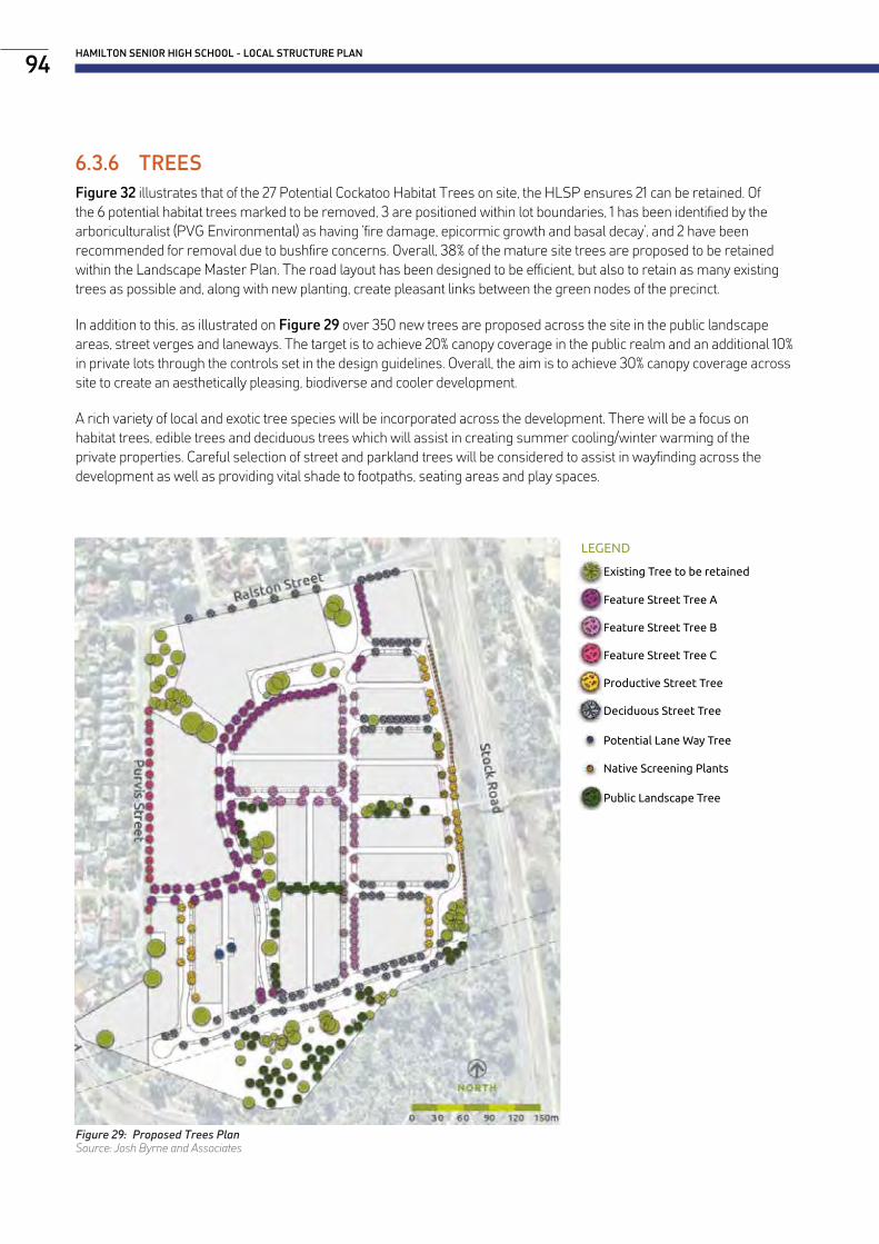
6.3.6 TREESFigure 32 illustrates that of the 27 Potential Cockatoo Habitat Trees on site, the HLSP ensures 21 can be retained. Of the 6 potential habitat trees marked to be removed, 3 are positioned within lot boundaries, 1 has been identified by the arboriculturalist (PVG Environmental) as having ‘fire damage, epicormic growth and basal decay’, and 2 have been recommended for removal due to bushfire concerns. Overall, 38% of the mature site trees are proposed to be retained within the Landscape Master Plan. The road layout has been designed to be efficient, but also to retain as many existing trees as possible and, along with new planting, create pleasant links between the green nodes of the precinct.
In addition to this, as illustrated on Figure 29 over 350 new trees are proposed across the site in the public landscape areas, street verges and laneways. The target is to achieve 20% canopy coverage in the public realm and an additional 10% in private lots through the controls set in the design guidelines. Overall, the aim is to achieve 30% canopy coverage across site to create an aesthetically pleasing, biodiverse and cooler development.
A rich variety of local and exotic tree species will be incorporated across the development. There will be a focus on habitat trees, edible trees and deciduous trees which will assist in creating summer cooling/winter warming of the private properties. Careful selection of street and parkland trees will be considered to assist in wayfinding across the development as well as providing vital shade to footpaths, seating areas and play spaces.
HAMILTON SENIOR HIGH SCHOOL - LOCAL STRUCTURE PLAN94
Figure 29: Proposed Trees PlanSource: Josh Byrne and Associates
PROPOSED TREE PLAN
NORTH0 15 30 45 60 75m
Feature Street Tree A
Feature Street Tree B
Existing Tree to be retained
LEGEND
Feature Street Tree C
Productive Street Tree
Deciduous Street Tree
Potential Lane Way Tree
Native Screening Plants
Public Landscape Tree

WATER SENSITIVE URBAN DESIGN (WSUD) INFRASTRUCTURE PLAN
Indicative Storm Water Flow Direction
Final Infiltration - Basin/ Infiltration Galleries
NORTH0 15 30 45 60 75m
POTENTIAL WSUD FEATURES LEGEND
Verge Infiltration Swales/ Gardens
Permeable Paving
THE STRUCTURE PLAN NOVEMBER 201995
Figure 30: WSUD Infrastructure PlanSource: Josh Byrne and Associates
6.3.7 LANDSCAPE BASED WSUD OPPORTUNITIESFigure 30 demonstrates that a range of landscape features have been proposed to contribute to at-source infiltration and treatment of stormwater and local replenishment of groundwater. A variety of systems such as tree pits, biofilters, vegetated swales and buffer strips will be included as part of the green corridors and streets. These systems will be vegetated with appropriate plant species to enable the treatment of stormwater. Where suitable, the front yards of lots will conform to the water sensitive design of verges for adequate provision of street-side landscape treatments where space is limited. The site’s final topography will be considered to enable stormwater to naturally flow into these green systems during minor and major rainfall events. Maximising on site retention and infiltration of stormwater in this manner will enhance soil moisture content, plant health and tree growth and substantially contribute to urban cooling via a greener landscape.
There will be the provision for public open space areas to accommodate the flows and volumes from larger rain events. These spaces will be designed to infiltrate stormwater while still serving an amenity function for the community. Other features that will be considered in the landscape design are the provision of permeable paving and underground storage under verges and roads to allow greater at-source infiltration of stormwater.
A description of the overarching integrated approach which has been adopted for stormwater management on the site is provided in “6.4 Environment”.
WSUD Example: Tree Pits
WSUD Example: Permeable Paving
WSUD Example: Sump (White Gum Valley)

6.4.1 URBAN WATER MANAGEMENTThis section of the Structure Plan has been informed by the Local Water Management Strategy (LWMS) prepared by Josh Byrne & Associates (refer Appendix G). The LWMS provides the platform for a suite of integrated, water-related sustainability initiatives to be implemented at this site and demonstrates the capacity of the land to sustain the proposed development in line with aspirations to be a leading water sensitive urban development. Implementation of the strategy will be undertaken in accordance with WAPC (2008) through the development and implementation of Urban Water Management Plans for individual stages of development within the site.
WATER EFFICIENCY INITIATIVESIt is envisaged that the project will seek to achieve accreditation under all six elements of the UDIA EnviroDevelopment sustainability accreditation framework including the water leaf. Water-related sustainability initiatives are described in full in the LWMS and include:
+ Maximised water efficiency measures;
+ Implementation of a coordinated approach to water sensitive landscaping including balanced hydrozoning and appropriate irrigation;
+ Maximising on site retention and infiltration of stormwater to enhance soil moisture content, plant health and tree growth;
+ Developing an estimate of overall water use with opportunities to displace mains water with alternative fit-for-purpose water sources; and
+ A community bore for public and private irrigation
A key design philosophy is to ensure that the landscape, and hence liveability, is not adversely impacted by the need to be water efficient.
STORMWATER MANAGEMENTIntegrated stormwater management will allow for passive treatment and infiltration of stormwater. A range of landscape features have been designed to contribute to the at-source infiltration and treatment of stormwater and local replenishment of groundwater. A variety of systems such as tree pits, biofilters, vegetated swales and buffer strips will be included as part of the green corridors and streets. These systems will be vegetated with appropriate plant species to enable the treatment of stormwater. Where suitable, the front yards of lots will conform to the water sensitive design of verges for adequate provision of street-side landscape treatments where space is limited. The site’s final topography will be considered to enable stormwater to naturally flow into these green systems during minor and major rainfall events.
There will be the provision for public open space areas to accommodate the flows and volumes from larger rain events. These spaces will be designed to infiltrate stormwater while still serving an amenity function for the community. Other features that will be considered in the landscape design are the provision of permeable paving and underground storage under verges and roads to allow greater at-source infiltration of stormwater.
Stormwater management is proposed to be undertaken consistent with Department of Water and Environmental Regulation water sensitive design practices. The system will consist of lot soakwells, permeable pavement, verge infiltration swales or gardens, ephemeral detention basins and underground storage areas within road reserves and POS to provide water quantity and quality treatment for stormwater generated from the proposed development.
Due to the constraints provided by the steep contours of POS areas, in particular in the northern section of the site, above ground storage typically adopted for stormwater management purposes was not practical to implement. Therefore, the use of above ground ephemeral storage areas within POS has been minimised for stormwater storage. Instead, the strategy has been to include underground storage as far up in the catchment as possible, to provide at source treatment of stormwater for storm events up to and including the 100 year ARI. Several basins have still been included across the site in areas where the topography would allow. Several catchments use a combination of underground and above ground storage to manage the major events.
6.4 Environment
HAMILTON SENIOR HIGH SCHOOL - LOCAL STRUCTURE PLAN96

The proposed stormwater management design has taken into consideration the existing trees that will be retained on site to form parts of the POS areas. Infiltration areas have been located in and around tree lines that will utilise the stormwater as a natural watering source, while the areas will also provide the necessary conveyance of stormwater away from the lots and roads.
No run-off to the road drainage system has been assumed from individual lots for events up to the 20 year 5 minute ARI. Consistent with City of Cockburn (2015), it has been assumed that each individual lot will retain all flows up to and including the 20 year 5 minute ARI event. A stormwater depth of 15mm has been allocated to this event for modelling purposes.
Within each catchment, road runoff will be collected through a series of pits and pipes for frequently occurring events (up to the 5 year ARI) with greater events travelling via overland flow paths. Storage will be via infiltration cells installed in an underground road reserve and/or in an aboveground infiltration basin located in POS.
The depth to groundwater in the development area is in excess of 40m from the existing natural surface and therefore imported fill and subsoil drainage will not be required for the site.
6.4.2 SUSTAINABILITY STRATEGYThe HSHS redevelopment project by LandCorp has the potential to be a leader, showing that excellent environmental outcomes can be combined with affordability in a high quality, desirable infill residential development. The project HAS BEEN designed in accordance with the City’s position on sustainability:
“Pursuing governance excellence to meet the needs of current and future generations through an integration of environmental protection, social advancement and economic prosperity.”
Some key sustainable development commitments at HSHS include:
+ A commitment to an independent assessment of the project’s environmental credentials using the UDIA’s EnviroDevelopment tool, targeting the highest level in all 6 elements including ecology, waste, energy, materials, water and community.
+ Energy and Water strategies developed to ensure that best practice in these areas is embedded in the design. See project documents Energy Strategy Report and Water Strategy Report.
+ Ecological restoration of the landscape onsite, retaining healthy trees, and adding more vegetation and canopy. See project document Landscape Report.
+ Landscape areas at the site are of both traditional indigenous and ecological importance, and will connect with the surrounding and nearby green spaces. Local management and conservation groups have already been identified and will be engaged with to support the site ecology ongoing.
+ Strong integration of the landscape design with WSUD principles.
+ Energy efficiency and renewable energy systems sized such that the total annual consumption of electricity will be matched by the annual renewable energy production - Nett Zero Operational Energy – with guidance on roof design and electrical infrastructure to enable these systems. The systems will also be ‘storage ready’ and may include energy storage capacity if the technology is sufficiently mature and financially viable at the time of procurement.
The Sustainability Strategy Report is provided in Appendix H. It is supported by the Energy Strategy (Appendix I) and Water Strategy (Appendix J) which provide recommendations for implementation. Both strategies are summarised below.
THE STRUCTURE PLAN NOVEMBER 201997

ENERGYEnergy Vision:A successful residential development with industry leading energy performance, supported by dwellings that are zero-energy-buildings. A heat resilient, future proofed community that provides a high standard of living with reduced cost and lower environmental impact.
Key Objectives: + Build on the work done at WGV by LandCorp to achieve excellent performance, and to embed successful piloted innovations from that project as scaled up initiatives on this project.
+ Taking the work done at the WGV project as a foundation for both scaling up and for further innovation.
+ Reduce energy use without impacting amenity, and meet remnant energy requirements with renewable energy.
+ Minimum 60% reduction in precinct-wide electricity consumption compared to a compliant, business-as-usual approach.
+ All single and double story buildings to be Zero Energy Buildings (ZEBs).
+ A development that seeks to reduce overall emissions compared to business as usual.
+ A development that provides a test-bed for innovations in energy.
+ Peak energy demand to be reduced through both efficiency and energy storage.
+ Citizen energy trading to be assessed against energy storage to capture excess electricity generation by dwellings.
+ Research partnerships to be in place to test new ideas.
+ Performance to be verified in annual reports for minimum 5 years after the build-out is complete.
+ Address both public and private realms.
+ Incentivise electric vehicle uptake.
WATERWater Vision:A successful residential development with industry leading performance across the water cycle achieved by adopting a fully integrated approach to water management. A water efficient, future proofed community that provides a high standard of living with reduced cost and lower environmental impact.
Key Objectives: + Consider the work done at WGV by LandCorp as a foundation for both scaling up and further innovation;
+ Identify and challenge barriers to innovation;
+ Become an accredited Waterwise development, certified by the Water Corporation, that seeks to reduce overall water consumption compared to business as usual;
+ Become a development that provides a test-bed for innovations in water capture, storage and water-use efficiency;
+ Become a development where water use is optimised to maintain and enhance a healthy ecosystem;
+ Implement best practice water design to support excellent outcomes in heat stress management, primarily through landscape and public realm design;
+ Identify research partnerships to test new ideas;
+ Address both public and private realms; and
+ Implement both the water-related and energy-related initiatives and innovations in a co-ordinated manner.
HAMILTON SENIOR HIGH SCHOOL - LOCAL STRUCTURE PLAN98

6.4.3 BUSHFIRE MANAGEMENTStrategen Environmental have prepared a Bushfire Management Plan (BMP) (Appendix M) based on the HLSPs proposed lot layout.
BUSHFIRE ATTACK LEVEL (BAL) CONTOUR ASSESSMENTThe BAL contours provided on Figure 31 are based on post-development conditions and take into consideration the proposed clearing extent, vegetation retention, landscaping and management of POS, resultant vegetation exclusions and separation distances achieved in line with the indicative subdivision plan. As only a small portion of the proposed subdivision design falls within the BAL-40 zone, it is recommended that building setbacks be used to mitigate the bushfire hazard.
Should there be any changes in development design or vegetation/hazard extent that requires a modified bushfire management response, then the above BAL contours will need to be reassessed for the affected areas and documented in a brief addendum to this BMP prepared to accompany future subdivision applications.
BUSHFIRE MANAGEMENT MEASURESAppendix M provides a detailed assessment of the proposed bushfire management measures for the HLSP. Key management measures include:
+ Asset Protection Zones, which consider;
- On-site fuel management
- POS fuel management
- Road reserve fuel management
- On-site staging buffers
+ Increased building construction standards;
+ Vehicular access management; and
+ Reticulated water supply.
EMERGENCY VEHICLE ACCESSAs shown on Figure 26 a cul-de-sac is proposed in the southwest corner of the site, to service Group Site 4 (Superlot 10). The BMP (Appendix M) prepared by Strategen identified that the cul-de-sac is compliant with acceptable solutions in that it is less than 200 m in length and has a suitable sized turn-around head. Further, inclusion of the cul-de-sac has been deemed unavoidable due to access restrictions onto Forrest Road to the southwest. The challenges associated with this connection can be summarised as follows:
+ A connection at the southwest corner of the site would be located on the inside of a bend on Forrest Road. Intersection locations on the inside of a bend should generally be avoided due to sight line problems.
+ Stock Road and the section of Forrest Road abutting the site are currently covered by Primary Regional Road Reservations in the MRS. Stock Road is identified as a future freeway in the Perth Transport Plan for 3.5 Million, so the Stock Road / Forrest Road intersection would ultimately be a grade-separated interchange (irrespective of the outcomes of Roe 8).
Advice from Transcore suggests that allowing new road connections close to future freeway interchanges is not typically supported, as such providing an additional road connection to Forrest Road within the frontage of the site should be avoided.
THE STRUCTURE PLAN NOVEMBER 201999
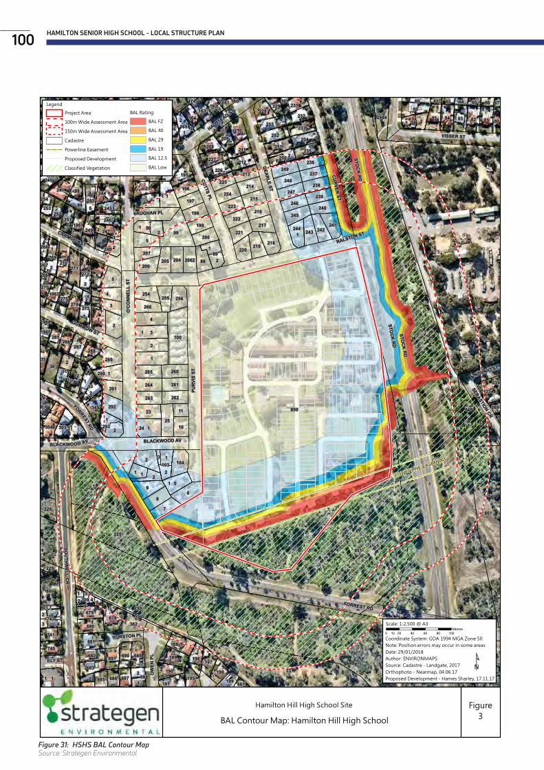
HAMILTON SENIOR HIGH SCHOOL - LOCAL STRUCTURE PLAN100
POWERLINE EASEMENT
850
1
101
851
1
100
231
801
225
230
1
1
101
99
11
1
100
11
2
31
1
4
6
2
111
1
1
1
2
951
6
1
3
4
2
5
8
5
3
1
1
7
33
1
24
2
1
11
36
2
3231
2303
2
800
2652
25
18
1
98
89
94823
678
289
8183 828485
293
59
1
58
1
1
2
34
304
12
2
1
2
1
194
2
248
1
1
241
1
88
2
681
10
1
2
2984
4
228
269
189
244
292
742
270
2
188
104
271
273
272
103
290
274
680
2
362
2
249
234
1
1
89
256
168
291
222
241
275
228
262
261
263
264
260265
220
679
232
218
228
689
219
206
244
254
1
210
2
237
1
196
209
217
1
208
220
288
204
233252
221
242
195
224
234
243
251211
243
166
225 235250
740
167
683
253
245
236249
219
224
222
226
196
197
199
198
200
709
237248
216240
214
245
207205
266
190
238
229
247
3
682
227
212
223
255
225
690
221
35
239
691
246
252251
253
215
227
240213
218
164163
223
198
197
5
11
170
2
169
287
246
247
741
231
226
191
277
39
4
1
285286
195
88
2062
2
80
2
1
162
687 199
230
686685
229
229
3
66
2
65
1
64
2 5
161
4
63
2
165
688
1963
1967
3
55
268
60
7
1965
238
3
1
3
269
5
3
3
62
6
171
3
667
217
6
3
56
235
67
801
3
267
3
254
301
40
11
3
174
266
9
160
1964
216
1
3
3
STOCK RD
FORREST RD
O'C
ON
NEL
L ST
RALSTON ST
PURV
IS S
T
SOU
THW
ELL CR
DEARLE ST
CUTTS PL
CURVEN ST
HALSTEAD ST
HILLIER CR
VISSER ST
GUMMOW ST
CARMODY ST
OW
EN P
L
ELY ST
SEBASTION CR
BLACKWOOD AV
YORSTON PL
VAUGHAN PL
Roe Hwy Extension
ANTONIO ST
STOCK RD
FORRESTRD
STOCK RD
BLACKWOOD AV
Hamilton Hill High School Site
BAL Contour Map: Hamilton Hill High School
Figure3
Legend
Project Area
100m Wide Assessment Area
150m Wide Assessment Area
Cadastre
Powerline Easement
Proposed Development
Classified Vegetation
BAL Rating
BAL FZ
BAL 40
BAL 29
BAL 19
BAL 12.5
BAL Low
C:\GIS\Jobs\Strategen\LAN17352.01 - Hamilton Hill High School Site, BMP\Figures\LAN17352-01_R001_RevA_F03_180129.mxd
Cre
ated
by
ENV
IRO
NM
APS
|
p: 0
406
590
006
e:
sim
onc
roft
s@en
viro
nmap
s.co
m.a
u
0 20 40 60 80 10010Metres
Scale: 1:2,500 @ A3
¹Coordinate System: GDA 1994 MGA Zone 50Note: Position errors may occur in some areasDate: 29/01/2018Author: ENVIRONMAPSSource: Cadastre - Landgate, 2017Orthophoto - Nearmap, 04.06.17Proposed Development - Hames Sharley, 17.11.17
Figure 31: HSHS BAL Contour MapSource: Strategen Environmental
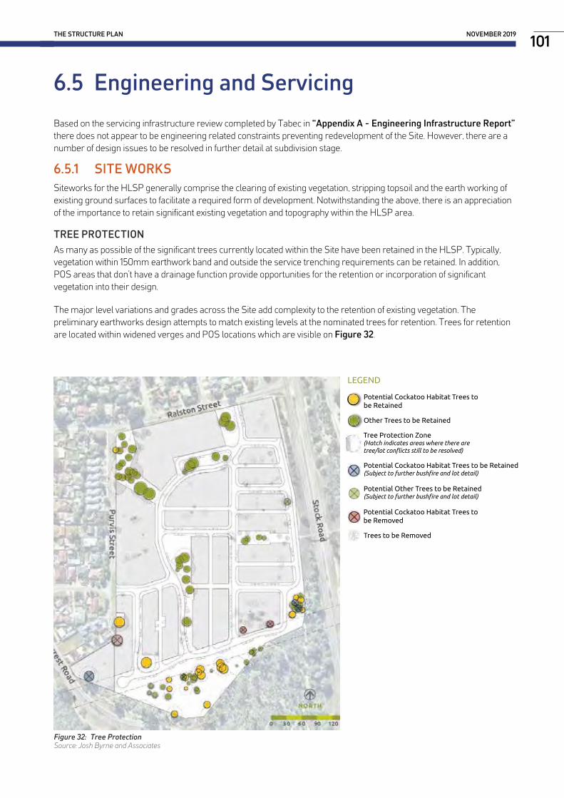
6.5 Engineering and Servicing
Based on the servicing infrastructure review completed by Tabec in “Appendix A - Engineering Infrastructure Report” there does not appear to be engineering related constraints preventing redevelopment of the Site. However, there are a number of design issues to be resolved in further detail at subdivision stage.
6.5.1 SITE WORKSSiteworks for the HLSP generally comprise the clearing of existing vegetation, stripping topsoil and the earth working of existing ground surfaces to facilitate a required form of development. Notwithstanding the above, there is an appreciation of the importance to retain significant existing vegetation and topography within the HLSP area.
TREE PROTECTIONAs many as possible of the significant trees currently located within the Site have been retained in the HLSP. Typically, vegetation within 150mm earthwork band and outside the service trenching requirements can be retained. In addition, POS areas that don’t have a drainage function provide opportunities for the retention or incorporation of significant vegetation into their design.
The major level variations and grades across the Site add complexity to the retention of existing vegetation. The preliminary earthworks design attempts to match existing levels at the nominated trees for retention. Trees for retention are located within widened verges and POS locations which are visible on Figure 32.
EXISTING TREES TO BE RETAINED & REMOVED PLAN (Rev G)
NORTH0 15 30 45 60 75m
LEGEND
Other Trees to be Retained
Potential Cockatoo Habitat Trees to be Retained
Trees to be Removed
Tree Protection Zone (Hatch indicates areas where there are tree/lot conflicts still to be resolved)
Potential Cockatoo Habitat Trees to be Removed
Potential Cockatoo Habitat Trees to be Retained (Subject to further bushfire and lot detail)
Potential Other Trees to be Retained (Subject to further bushfire and lot detail)
THE STRUCTURE PLAN NOVEMBER 2019101
Figure 32: Tree ProtectionSource: Josh Byrne and Associates

DEMOLITION AND REMEDIATIONUpon closure of the High School, all existing buildings and improvements are proposed to be demolished and removed. It is anticipated that due to the age of the buildings, it is likely at the time of construction that asbestos containing materials were used. Therefore, a Detailed Site Investigation and Hazardous Material Survey will be undertaken by a qualified environmental consultant once the school closes which will inform the preparation of the Remediation Action Plan. Removal of hazardous materials will be undertaken by licensed contractors, prior to demolition where possible, and validated by the environmental consultant. Dust monitoring will be undertaken throughout the demolition phase by accredited consultants.
There are various materials which will be salvaged from the existing buildings for reuse on-site to minimise waste disposal and be used in various landscape treatments. The required materials which are identified for re-use, will be removed and protected at the commencement of demolition works.
6.5.2 EARTHWORKSTabec have identified that significant earthworks will be required to enable development of the Site. A preliminary earthworks design has been undertaken for the HLSP it demonstrates the following:
+ Finished development levels will need to account for existing road and interface levels on each boundary. This includes road intersections onto both Ralston and Purvis Streets which will both be accessible for direct lot access for lots fronting those roads.
+ Existing levels need to be maintained along the Stock Road boundary, where an existing water main and pedestrian footbridge determine interface levels. Also, the existing levels beneath the Western Power transmission line easement are not able to be raised and are sought to be maintained as closely as practical to the current elevations.
+ In terms of the site preparation, after stripping of existing pavements, vegetation and topsoil, the exposed ground shall be proof compacted. The loose sand requires additional treatment, particularly at the location of grouped sites where up to three (3) storey buildings are proposed.
+ Significant cut-to-fill will be undertaken during the earthworks program. The final earthworks design will seek to maintain existing levels around trees identified for retention, which introduces fixed design levels to be maintained throughout the project area. As a result, while re-contouring is necessary there are major level differences between lots which are to be managed through an approach which includes a combination of both retaining walls and split-level lots.
+ Split level lots are nominated up to 3m in height to allow for 2 storey construction stepping to a single storey at either the front or rear. This includes over-garage living areas for lots fronting Ralston and Purvis Streets. It is envisaged that retaining walls would be constructed to create the split-level lots during the civil works program rather than during the house construction stage.
+ Despite the re-contouring necessary, existing site features such as the north-south aligned 2.5m high ridge separating the playing fields will be retained in a widened road verge. Higher areas on-site are also sought to be maintained without significant cut, as there is potential for various view corridors toward the coast and Darling Scarp.
Preliminary earthworks concepts are provided in Appendix A.
HAMILTON SENIOR HIGH SCHOOL - LOCAL STRUCTURE PLAN102

6.5.3 ACOUSTIC ASSESSMENTA Transportation Noise Assessment was completed by Lloyd George Acoustics in response to the requirements of SPP 5.4 Road and Rail Transport Noise and Freight Considerations in Land Use Planning (SPP 5.4) due to the Site’s location next to Stock Road.
Noise monitoring was undertaken on both Forrest Road and Stock Road, adjacent to the Site. The monitoring was undertaken between 15 and 19 June 2017, to obtain 5 full weekdays of data.
To mitigate the traffic noise it is recommended that a noise barrier be constructed on the eastern site boundary. The material used for the barrier would require a surface density of at least 15 kg/m2. The required location and minimum height of the barrier is shown in Appendix D, which illustrates that a 4.0m high noise wall along Stock Road will be necessary to adequately mitigate noise from future traffic conditions. The wall shall overlap to provide an opening at the footbridge location (Figure 34). A 2.0m high noise wall is also considered necessary in the south-west corner of Group Site 4 (Super Lot 9) adjacent to Forrest Road (Figure 33).
4.0
3.83.43.0
3.23.6
3.8
3.22.8
2.6
3.2
3.02.62.4 Lloyd George Acousticsby Daniel [email protected](08) 9300 4188
Scale0 15 30 60 90 120 150
m
Hamilton Hill Senior High School Redevelopment - Noise Wall Detail Figure B1
Signs and symbolsBuilding
Wall
4.0
3.83.43.0
3.23.6
3.8
3.22.8
2.6
3.2
3.02.62.4 Lloyd George Acousticsby Daniel [email protected](08) 9300 4188
Scale0 15 30 60 90 120 150
m
Hamilton Hill Senior High School Redevelopment - Noise Wall Detail Figure B1
Signs and symbolsBuilding
Wall
Noise levelsLAeq,Day dB
< 5555 <= < 56 Package A56 <= < 5757 <= < 5858 <= < 5959 <= < 6060 <= < 61 Package B61 <= < 6262 <= < 6363 <= < 64 Package C64 <= < 6565 <= Specialist Advice
Lloyd George Acousticsby Daniel [email protected](08) 9300 4188
Scale0 4 8 16 24 32 40
m
Hamilton Senior High School Redevelopment - Noise Wall to Accommodate Pedestrian BridgeLAeq,Day Noise Level Contours Figure 1
Signs and symbolsBuilding
Wall
THE STRUCTURE PLAN NOVEMBER 2019103
Figure 33: Noise Wall ExtentSource: Lloyd George Acoustics
Figure 34: Noise Wall OpeningSource: Lloyd George Acoustics

PART THREE TECHNICAL APPENDICES


Civil Engineering Consultants
HAMILTON SENIOR HIGH SCHOOLEngineering Infrastructure Report
TABEC Pty Ltd
October 2019
Appendix A - Engineering Infrastructure Report

Report onGeotechnical Investigation
Proposed Residential DevelopmentHamilton Senior High School
Prepared forTabec Pty Ltd
Project 88913 July 2017
Appendix B - Geotechnical Investigations

Hamilton Senior High School Redevelopment
Transport Impact Assessment
PREPARED FOR: LandCorp July 2017
Appendix C - Transport Impact Assessment
Appendix D - Transportation Noise Assessment
Lloyd George Acoustics POBox717
HillarysWA6923T:93004188F:93004199www.lgacoustics.com.au
Transportation Noise Assessment
Hamilton Senior High School Redevelopment Reference: 16103756-01 draft
Prepared for: Tabec

HAMILTON SENIOR HIGH SCHOOL , HAMILTON HILL
FLORA, VEGETATION AND BLACK COCKATOO HABITAT SURVEY
Prepared for: LandCorp
Report Date: 12 June 2018
Version: 2
Report No. 2016-304
Appendix E - Flora and Fauna Survey
L ANDSC APE MASTER PL AN REPORTHAMILTON SENIOR HIGH SCHOOL REDEVELOPMENT
Appendix F - Landscape Master Plan

TITLE Local Water Management Strategy - Hamilton Senior High School Redevelopment
AUTHOR Josh Byrne & Associates
PREPARED FOR LandCorp
DATE April 2018
Appendix G - Local Water Management Strategy

L AN D S C A P E • S U S TA I N A B I L I T Y • C OM MU N I C AT I O N S T 08 9433 3721 E [email protected] W joshbyrne.com.au
A Suite 109 Atwell Buildings 3 Cantonment Street Fremantle WA 6160
TITLESUSTAINABILITY STRATEGY
Hamilton Senior High School Redevelopment
AUTHOR Josh Byrne & Assoc.
PREPARED FOR LandCorp
DATE March 2018
Appendix H - Sustainability Strategy Report
TITLE Energy Strategy - Hamilton Senior High School Redevelopment
AUTHOR Josh Byrne & Associates
PREPARED FOR LandCorp
DATE November 2017
Appendix I - Energy Strategy Report
TITLE Water Strategy - Hamilton Senior High School Redevelopment
AUTHOR Josh Byrne & Associates
PREPARED FOR LandCorp and Water Corporation
DATE November 2017
Appendix J - Water Strategy Report

C000258 LandCorp
2017
Hamilton Hill Senior High School Project Aboriginal Engagement Strategy 23 AUGUST 2017 AUTHOR: INGRID CUMMING
Appendix K - Aboriginal Engagement Strategy

C O N S U L T I N G
October 2017
Author: Damien Lafrentz
TRCo Ref: LAN1701
Report on an Aboriginal Heritage Survey and Consultation with Whadjuk Traditional Owners of the proposed Hamilton Senior High School re-development, for LandCorp
Appendix L - Aboriginal Heritage Survey

Appendix M - Bushfire Management Plan
Level 1, 50 Subiaco Square Road Subiaco WA 6008 PO Box 243 Subiaco WA 6904 Phone (08) 9380 3100 Fax (08) 9380 4606 177 Spencer Street Bunbury WA 6230 PO Box 287 Bunbury WA 6231 Phone (08) 9792 4797 Fax (08) 9792 4708
LAN17352_01 M001 Rev 0 30-Jan-18 1
To: Naomi Lawrence Date: 30 January 2018
Company: LandCorp Project No: LAN17352.01
Email: [email protected] Inquiries: Zac Cockerill
Bushfire Management Plan Addendum Structure Plan: Hamilton Hill High School site
1. Background
LandCorp (the developer) is progressing planning approval for proposed urban development over the former Hamilton Hill High School site. The proposal encompasses land contained within Crown Reserve 37938, including Lot 2687 Purvis Street and Lots 2716 and 2717 Stock Road, Hamilton Hill in the City of Cockburn (hereon referred to as the project area).
A Metropolitan Region Scheme (MRS) amendment has been lodged to rezone the project area from ‘Public Purposes (High School)’ to ‘Urban’, informed by a Bushfire Management Plan (BMP) prepared by Strategen in August 2016. As part of the next planning stage, a Structure Plan (SP) is proposed. The indicative subdivision plan prepared as part of the SP process (Figure 1) identifies 224 single residential lots, four grouped housing lots, areas of Public Open Space (POS), internal road layout and Public Access Ways (PAWs).
A portion of the project area is designated as bushfire prone on the WA Map of Bush Fire Prone Areas(DFES 2017) due to the extent of on-site and adjacent vegetation. Strategen has prepared this BMP addendum as an update to the previous BMP to accompany the SP and address the following requirements of State Planning Policy 3.7 Planning in Bushfire Prone Areas (SPP 3.7; WAPC 2015) Policy Measure 6.3:
• since indicative lot layout is known, a Bushfire Attack Level (BAL) contour map to determine the indicative acceptable BAL ratings across the subject site, in accordance with Guidelines for Planning in Bushfire-Prone Areas (the Guidelines; WAPC 2017)
• identification of any bushfire hazard issues arising from the BAL contour map • re-assessment against the bushfire protection criteria requirements contained within the
Guidelines demonstrating compliance with the Guidelines can be achieved in subsequent planning stages.
This BMP addendum has been prepared in accordance with the Guidelines and addresses all of the above information requirements to satisfy SPP 3.7.


