HASAN BASYRI DAULAY1, NORHAN ABD. RAHMAN2, AMIR HASHIM MOHDKASSIM3 & KAMARUL AZLAN MOHD NASIR4
Abstract. Tioman Island which is situated in the southeast of Pahang State is one of the smallislands in Malaysia that have been promoted as a tourism destination. Based on the previous study,the island requires more than 2000 m3/day of water for domestic and tourism industry consump-tion, and the demand is expected to rise due to the increasing population and tourism activities.Study on surface water and groundwater indicate a good potential for water resources to meet thedemand of the future water needs. An intensive study is being carried out to investigate the quan-tity of water resource that is available in this island. In this study, the amount of surface water flowwas estimated by using MIKE 11 NAM Model, and for groundwater extraction ASM (AquiferSimulation Model) was used. This paper reports the preliminary findings of the amount of thewater resources available in Kg. Tekek, Tioman Island, i.e. the daily average of surface runoff is3024 m3/day and the groundwater extraction is 5003 m3/day, that was calculated for the period ofFebruary 1999.
Key words: surface water, groundwater and small island
Abstrak. Pulau Tioman terletak di sebelah tenggara Negeri Pahang merupakan salah satu daripulau-pulau kecil di Malaysia yang sudah dimajukan sebagai destinasi pelancong. Berdasarkanpenyelidikan terdahulu, pulau ini memerlukan bekalan air bersih melebihi 2000 m3/hari untukkeperluan penduduk tempatan dan pelancong, dan keperluan ini akan meningkat denganpeningkatan jumlah penduduk dan pelancong. Penyelidikan terhadap air larian permukaan danair bumi menunjukkan bahawa keduanya berpotensi sebagai sumber air yang baik untuk memenuhikeperluan air pada masa hadapan. Suatu kajian yang intensif dilaksanakan untuk mengkajikeupayaan sumber air yang sedia ada bagi pulau ini. Untuk menentukan berapa banyaknya airlarian permukaan, perisian model MIKE 11 NAM digunakan, dan untuk menentukan keupayaanair bumi yang boleh dipam, ia berpandukan kepada perisian Aquifer Simulation Model (ASM).Kertas kerja ini membentangkan penemuan permulaan bagi jumlah sumber air yang sedia ada diKg. Tekek Pulau Tioman, purata air larian permukaan harian adalah 3024 m3/hari dan air bawahtanah yang boleh dipam adalah sebanyak 5003 m3/hari, yang dikira untuk tempoh bulan Februari1999.
Kata kunci: Air larian permukaan, air bumi dan pulau kecil
1,2,3&4 Faculty of Civil Engineering, Universiti Teknologi Malaysia, 81310 Skudai, Johor Darul Takzim,Malaysia.
Untitled-34 02/16/2007, 17:2451
HASAN BASYRI, NORHAN, AMIR HASHIM & KAMARUL AZLAN52
1.0 INTRODUCTION
1.1 General
Based on the previous study by Nazan Awang and Loganathan [1], in TiomanIsland have been investigated, two areas namely, Kampung Tekek and KampungJuara, which have a good potential for exploitation of surface water and ground-water. The current study is concentrated in Kampung Tekek, and intend to assessthe maximum annual water yield from surface water and groundwater. For thispurpose, available models were used to calculate and simulate the hydrological andhydrogeological data.
In hydrological analysis, long term data are required for any decision. Unfortu-nately, in the present study such long term data are not available. However, thepresent study uses the rainfall data of 14 years (1986–1999) during which the data in1993 and 1995 are not available. Also there are many missing rainfall data from1991 to 1997.
The evaporation data taken from Mersing (1986-1999) were used because there isno evaporation station in Tioman Island. The evaporation station in Mersing is thenearest station to Kampung Tekek.
The runoff data are available one month only. Precipitation, evaporation andrunoff data are not complete. Simple Arithmetic Average Method were used forfilling up the missing data.
The main river in the catchment area of Kampung Tekek is Ayer Besar River,which does not have a stream flow gauge. In the case of groundwater level fluctua-tion, long term data are also required but only a 10 month-data record is available.
After treating all of the data properly, the magnitudes of surface water runoff andthe maximum extraction of groundwater can be predicted by simulation using exist-ing models, namely MIKE 11 NAM Model and ASM (Aquifer Simulation Model)for surface water and groundwater, respectively. The results of the water simulationare compared with the observed data, and the potential of surface water and ground-water resources are then examined.
1.2 Brief Description of the Study Area
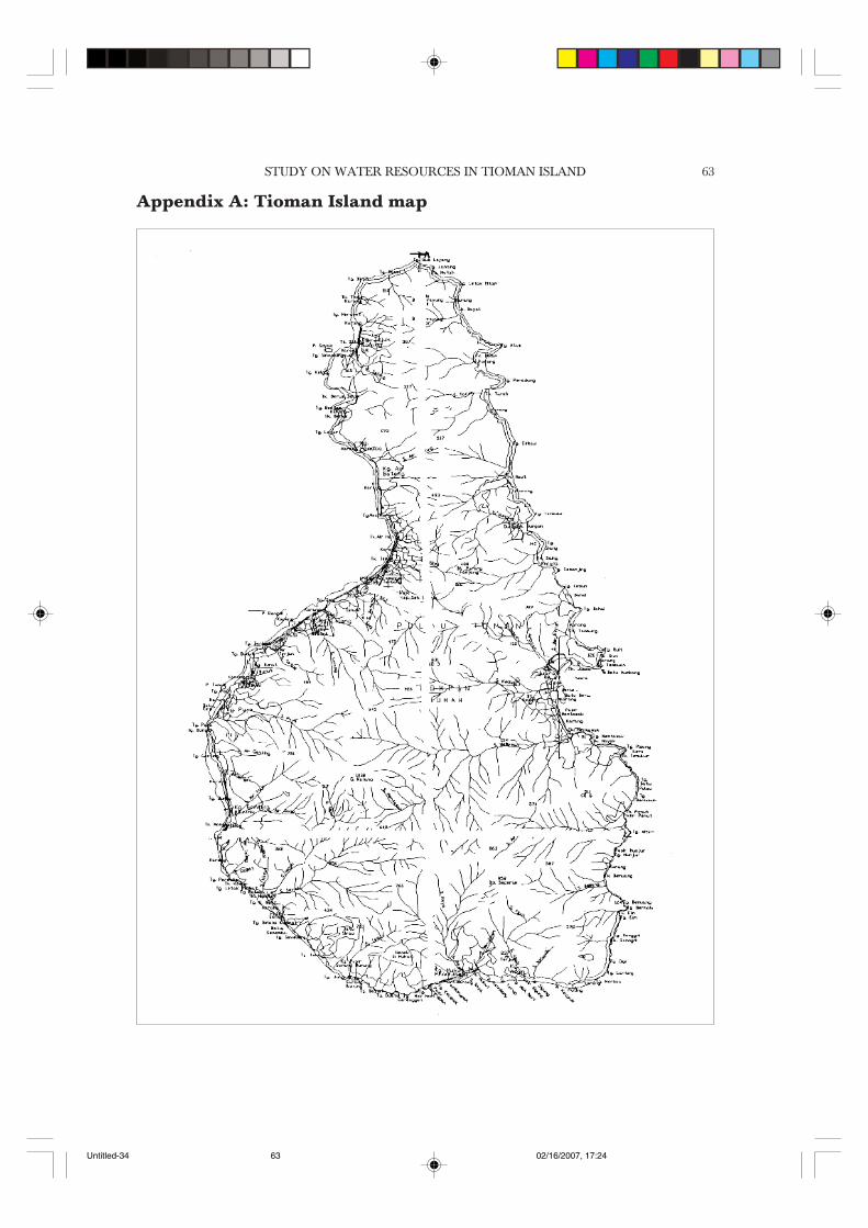
Tioman Island situated in the State of Pahang is one of the islands in Malaysia thathave been promoted as a tourist destination. It is located east of Peninsular Malaysiaat 2° 43' 00" to 2° 54' 00" N latitude and 104° 6' 00" to 104° 12' 30" E longitude (seeAppendix A). The area of the island is about 131 km2, with a maximum width ofabout 11 km (west to east) and a maximum length of about 20 km (north to south).It is the largest small island among a group of 64 volcanic islands. The coast ofTioman Island is predominantly featured with rocky hills with green flora on thetop.
Untitled-34 02/16/2007, 17:2452
STUDY ON WATER RESOURCES IN TIOMAN ISLAND 53
There are many big stones arrangement like a stronghold on the foothills at theseaside. In some places there are beautiful sandy beaches and the narrow plains,such as Kampung Tekek, Kampung Salang, Kampung Juara, Kampung Mukut,Kampung Pasir, Kampung Nipah, Kampung Genting, Kampung Paya and KampungLalang. Each of them has a sandy beach as a recreation area which attracts visitors.In general, the island is still in pristine condition with a crystal clear azure sea andrich marine life.
2.0 TIOMAN ISLAND’S CONDITION
2.1 Topography
The terrain of the island is quite steep, rising from 75 m to 1,040 m above mean sealevel, resulting in short and steep river profiles. About 12 km2 of the island’s areafalls in the range of slope between 09 to 30°, while about 119 km2 is having slopegreater than 30°. Approximately 90% of the land is occupied by slope greater than30° [4]. In the hinterland, there are hills, mounts, and plateau, covered by flora oftropical forest, namely Gunung Kajang (1,038 m), Gunung Rombin Tioman (976m), Gunung Seperak (958 m), and Bukit Nenek Semukut (766 m). There are manysmall rivers, and the largest river is Sungai Mentawak (about 5.5 km). Ayer BesarRiver basin lies in Tekek Area. Keliling River basin and Baharu/Air Dalam Riverbasin lie in Juara Area. The down stream area of the basins are coastal plains.
2.2 Geology and Hydrogeology
Tioman Island is made up mainly of Triassic granite with Permian volcanic at theeastern part of the island. In low lying areas such as Kampung Tekek, they aregenerally made up of thin layers of alluvium consisting silt, sand and gravel withsome clays and corals. The study area is classified as an unconfined aquifer compris-ing mainly of about 14-m thick medium to coarse sand with coral along the coast.Geophysical investigation using gravity method showed that the overall coral thick-ness is most likely within 7 to 20 m [2].
Hydro-geological factors have a major influence on the distribution of ground-water on an island. These factors include the permeability and porosity of the rocksand sediments, and the presence and distribution of karstic features such as smallcave systems and solution cavities. Surface water resources prevail only on islandswith relatively low permeability. Groundwater resources are most abundant on smallislands with moderate to high permeability and porosity. Size, shape and topo-graphy of a small island are major influences on the occurrence of both surface andgroundwater resources [3].
The geology of Tioman Island was well described by Bean [1972]. This island isunderline mainly by granite rock/hard rocks which mean has least groundwater
Untitled-34 02/16/2007, 17:2453
HASAN BASYRI, NORHAN, AMIR HASHIM & KAMARUL AZLAN54
potential, and a thin narrow belt of metamorphosed volcanic and sedimentary rocksalong the north and east coast of the island. Meanwhile the alluvium which has abetter prospect for groundwater development were found only on the limited areas,patches along coastline at low lying area such as Kampung Tekek, Salang, Juara,Paya, Genting and Mukut. Most of those areas except in Kampung Tekek andJuara, the alluvium were confined to limited area along coastline and it does notform extensive aquifers.
2.3 Climate
The study area has a tropical climate characterized by uniformly high temperatureand high relative humidity. It can be said that, tropical islands exhibit little variationin temperature [Falkland, 1992] yet, on a regional scale. The most important factorsthat control the annual variation of tropical convection are the annually varyingthermal contrast between land and ocean and the annual cycle of sea surface tem-perature [Wang, 1994] with mean temperatures in January and July of about 25°Ccompared to 28°C during the 1982 Elnino [see, e.g., Ooi, 1999], [4].
The highest monthly temperature varying from 30.0°C to 38.1°C, the lowestmonthly temperature ranging from 20.5°C to 26.8°C, and the mean monthly tem-perature ranging from 24.1°C to 31.7°C, from September 1998 to August 1999. Themean monthly relative humidity varying between 75% to 86%, depending on monthfrom September 1998 to August 1999 [5].
The climate of an island has a very large influence on its environment, hydrologi-cal cycle and water resources. Among the climatic variables, rainfall contributessignificantly to the local hydrology. It is the source of supply of all surface andsubsurface water. The quantity of available water resources varies daily, monthlyand yearly depending on prevailing wind flows with affect the rainfall pattern. Thepresence of large water body surrounding has great influence on the climate of theisland. As Tioman Island in situated within the Asian monsoon regime, monsooneffects modify its climate.
The rainy season in Tekek from July to January and in Juara from August toJanuary are affected by the northeast monsoon whereas the dry season in Tekekoccurs from February to June and in Juara from February to July.
3.0 WATER RESOURCES OF STUDY AREA
The main factors influencing hydrological processes and the nature of surface andgroundwater resources on small tropical islands are physiography, climate andhydrology, geology and hydrogeology, soil and vegetation, and human impacts,including abstraction and pollution from a variety of sources. For low islands andlow lying areas of high islands, sea level movements due to tides, pressure changesand longer term influences are also important factors [3].
Untitled-34 02/16/2007, 17:2454
STUDY ON WATER RESOURCES IN TIOMAN ISLAND 55
Water resources for this study area can be divided into surface water resourceand groundwater resource. At present, surface water is used for domestic and tour-ism industries purposes, as untreated water by direct supply from small collectingdam.
3.1 Surface Water
Surface water for Tekek Village is obtained mainly from Ayer Besar River whereasfor Juara Village is obtained from Baharu River and Keliling River. But there is nostreamflow gauge on these rivers.
The value of streamflow can be measured directly and calculated or predict byusing MIKE 11 NAM Model (Nedb⊥r-Afstr∅mnings-Model means precipitation-runoff-model). The results of the simulation of the Mike 11 NAM model are shownin Figure 1, 2 and 3. These results are tentative results, because collecting flow dataare not finish yet. Until now the observed flow data is only in July 1987.
The rainfall data for 1993 and 1995 are not available. And there are many missingrainfall data in 1991 to 1997. Therefore, Simple Arithmetic Average Method wereused to fill up the missing data.
The average and the maximum value of the runoff were calculated from therunoff prediction for 1986 to 1999 as much as 0.035 m3/sec and 1914 m3/sec, respec-tively.
Figure 1 Runoff prediction of Tekek Basin from 1986 to 1999 and the observed flow data inJuly 1987
Untitled-34 02/16/2007, 17:2455
HASAN BASYRI, NORHAN, AMIR HASHIM & KAMARUL AZLAN56
Figure 2 The maximum runoff prediction from 1986 to 1999
Figure 3 The runoff prediction and the observed flow in July, 1987
+++++++ = Observed Flow = Calculated Flow
Untitled-34 02/16/2007, 17:2456
STUDY ON WATER RESOURCES IN TIOMAN ISLAND 57
3.2 Groundwater
Tekek Aquifer has good potential of groundwater resource. The study shows thatTekek area can produce water of 1,368 m3/day [1]. Generally, groundwater on highisland like Tioman Island, occurs in form of elevated (high level) or basal (low-level)aquifer. Basal aquifer, which usually takes form of fresh water lens, is more impor-tant as groundwater resource. Assessment of water resources and their sustainableyields are paramount importance for small islands where demands for clean watersupply are seasonally fluctuated in nature.
Groundwater resources are most abundant on islands with moderate to high per-meability and porosity. Generally, the hard rock aquifers do not have very highprimary porosity or permeability compares to alluvial aquifers. The water yieldingproperties in hard rocks aquifer are largely dependent on the occurrence of second-ary features such as fracture, cavities, joint and fault zones. The hard rocks aquiferwill only yield limited water compare to alluvial aquifers. Therefore groundwaterfrom alluvial aquifers is more favored than hard rock aquifers.
The ASM model (Aquifer Simulation Model) was used to predict the maximumextraction from the Tekek aquifer by giving the certain amount of pumping ratesand in a certain time that causes the groundwater level to be same with or littlehigher than mean sea level, in order to protect saline intrusion.
3.2.1 Aquifer Simulation Model for the Tekek Aquifer
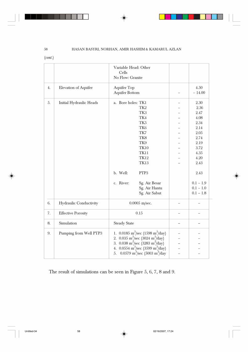
The whole data of the Aquifer Simulation Model can be found in Table 1 andboundary condition of the aquifer is described in Figure 4.
Figure 9 The result of the fifth pumping (5003 m3/day) of Tekek Aquifer
According to the simulation graph, the suitable result of the maximum extractionin Feb. 1999 is the fifth pumping as much as 5000 m3/day, because sea water stilldoes not enter to the aquifer area, and water head in the well (–5.058 m) is stillhigher than aquifer bottom (–14.00 m). After running all the available initial headdata in one year, the daily average extraction can be determined.
Untitled-34 02/16/2007, 17:2460
STUDY ON WATER RESOURCES IN TIOMAN ISLAND 61
3.3 Problems Faced
In this study some problems are faced that must be overcome. The problem are
(a) hydrological missing data. Rainfall data are not available for some months in ayear or in a series of years, and there is no evaporation data in Tioman Island,because of there is not at all the evaporation station.
(b) the greater parts of topography are hilly. This causes difficulty to build surfacestorage. But, subsurface storage can be built if needed.
(c) Not enough availability of socioeconomic data.
4.0 CONCLUSIONS
Based on the previous study, Tioman Island requires more than 2000 m3/day ofwater for domestic and tourism industry consumption, and the demand is expectedto rise due to increasing population and tourism activities. This study shows thatTioman Island has a good potential of surface water and groundwater resources.From this study, it was found that the daily average of surface runoff is 3024 m3/dayand of groundwater extraction is 5003 m3/day, calculated for the period of February1999.
ACKNOWLEDGEMENT
This study was financially supported by Faculty of Civil Engineering, UTM underthe International Hydrological Programme (IHP). We would like to express ourgratitude for providing financial support for this study.
REFERENCES[1] Mohd. Nazan Awang and P. Loganathan, P.J.K. 1991. Prospek Sumber Air Tanah Pulau Tioman Pahang.
Jabatan Penyiasatan Kajibumi, Malaysia. Projek Kajian Sumber Air Tanah, Semenanjung Malaysia,Lampiran 2.
[2] Mohammad Hatta A. K, B. B Abdul Rashid and B. A. Mohd. Nazan. 1993. Hydrology and Model Analysisof Kg. Tekek Aquifer System, Tioman Island, Pahang. Jabatan Penyiasatan Kaji Bumi Malaysia.
[3] Falkland, T. 1997. Research in Humid Tropics Island Hydrology:Curren Knowledge and Future. DirectionWorkshop on local scale hydrological processes in island, highlands, and urban environments in Malay-sia. Kuala Lumpur Malaysia.
[4] Mohd.Nor Mohd.Desa, HTC. 1999. The Prospect of Tropical Island Water Resources And A Case ofTioman Island, Malaysia. First Workshop on Tioman Island Hydrological Study, 3 – 4 June 1999.
[5] Mohd. Rosaidi C. A. 2000. Climatological Study of Tioman Island, The Regional Conference on Hydro-logy and Environment of Small Islands, 29th – 31st May 2000, Berjaya Tioman Beach Resort TiomanIsland, Malaysia.
[6] Amir Hashim Mohd.Kassim, Norhan Abd. Rahman, Kamarul Azlan Hasan Basyri Daulay, AnuarMohmood and Azmi Aris. 1999. Preliminary Study For Tioman Island Water Resources and HydrologicalProcesses, Research Seminar On: CONSTRUCTION, MATERIALS AND ENVIRONMENTAL TECH-NOLOGY, 3 – 4 February 1999' UTM, Johor Bahru.
Untitled-34 02/16/2007, 17:2461
HASAN BASYRI, NORHAN, AMIR HASHIM & KAMARUL AZLAN62
[7] Ahmad Fauzi Abd. Majid, Lembaga Pembangunan Tioman Pahang Darul Makmur. 1999. Future Deve-lopment of Tioman Island. First Workshop On Tioman Island Hydrological Study, 3 – 4 June 1999.
[8] Hashim Amir, and Daulay, Hasan B. 2000. Conjunctive use of surface andground water resources in TiomanIsland. The Regional Conference on Hydrology and Environment of Small Islands, 29 – 31 May 2000,Berjaya Tioman Beach Resort, Tioman Island, Malaysia.
[9] Mohd. Nazan Awang. 1988. Kajian Keseimbangan Air di Kampung Tekek dan Kampung Juara, PulauTioman. Laporan Persidangan Geologi Tahunan yang ke-19, 1988, jilid 2, JPK, Malaysia.
[10] Norhan Abd. Rahman, Amir Hashim, Hasan Basyri Daulay, and Kamarul Azlan. 1999. Hydrologicaland Water Resources Study for Tioman Island, FRIM Seminar, March, 1999, Kuala Lumpur.