§ 185-1. Establishment of regulations. Whereas the Town of Rutland has created a Planning Commission and has adopted and has in effect a Town Plan^ under the Vermont Planning and Development Act, 24 V.S.A. Chapter 117, herein referred to as "the Act," there are hereby established subdivision regulations for the Town of Rutland. § 185-2. Title. This chapter shall be known as the "Town of Rutland Subdivision Regulations." § 185-3. Subdivision and development subject to town control. It is hereby declared by the Town of Rutland that consideration of the subdivision of land and the subsequent development of the subdivided plat is subject to the control of the municipality, pursuant to the Town Plan, which calls for the orderly, efficient and economical development of the town. § 185-4. Conditions prerequisite to subdivision. Land to be subdivided shall be of such a character that it can be used safely for building purposes without danger to health or peril from fire, flood or other menace, and land shall not be subdivided unless proper provision has been made for drainage; erosion control; water; sewage; and capital improvements, such as schools, parks, recreational facilities, transportation facilities and improvements. § 185-5. Considerations. The Selectmen of the Town of Rutland, pursuant to the authority conferred upon them by 24 V.S.A. Chapter 117, hereby adopted the following regulations governing the subdivision of land. The Rutland Town Planning Commission shall administer these regulations for the purpose of assuring orderly growth and coordinated development in
the Town of Rutland and to assure the comfort, convenience, safety, health and welfare of its citizens. Furthermore, the review of subdivision regulations shall be based on the following broad considerations: A. Conformance with and implementation of the Town Plan, zoning regulations and other applicable bylaws. B. Recognition of a desirable relationship to land form, topography, geology, groundwater and surface water hydrology, including the natural drainage pattern, and to the groundwater table. C. Recognition of desirable standards of subdivision design, including provision for safe and convenient pedestrian and vehicular traffic and for suitable building sites for the land use contemplated. D. Provision of adequate safeguards to protect the general public from the perils and hazards of flooding, fire, soil erosion, air and water pollution or other threats to public health, safety and welfare. E. Provision for the preservation, protection and for conservation of natural resources, such as land, air, vegetation, water, agricultural and visual resources, upon which the continued prosperity of the Town of Rutland and surrounding region depend. F. Provisions for public facilities and services, such as neighborhood parks, open space, other recreation areas, school sites, police and fire protection, off-street parking, water supply, sewage disposal, and other facilities and services deemed necessary for general public health and convenience. G. Encouragement of variety, innovation, flexibility, greater efficiency and open space in the designing layout and use of land in cluster, planned unit and planned residential developments as provided under the Vermont Planning and Development Act. § 185-6. Authority of Planning Commission. The Commission is hereby authorized and empowered to do all acts and things set forth and provided in § 4401 and §§ 4413 through 4421 of the Act, including but not limited to the approval, modification or disapproval of all plats filed and the approval of the development of such plats previously filed in the Town Clerk's Office if such plat or plats are entirely or partially undeveloped under the subdivision regulations.
§ 185-7. Waivers and variances. The procedures and requirements for the submission and processing of plats and the standards for the design and layout established by this chapter may be waived or varied by the Planning Commission, subject to appropriate conditions, when the Planning Commission finds that compliance with any procedure, requirement or standard is not requisite in the interest of the public health, safety and general welfare due to the special circumstances of a particular plat or plats or is inappropriate because of inadequacy or lack of connecting facilities adjacent or in proximity to the subdivision; however, any waiver or variance granted shall pertain only to that particular subdivision for which it was granted and shall not set a precedent for similar action for any other subdivision. When a waiver or variance has been requested with respect to a subdivision application, the notice of the public hearing on such application shall specify that such has been requested, the section or sections of this chapter to which the request pertains and a concise statement of the nature and the reasons for the request. § 185-8. Amendments. This chapter may be amended according to the requirements and procedures established in §§ 4403 and 4404 of the Act. § 185-9. Enforcement. This chapter shall be enforced in accordance with §§ 4444 and 4445 of the Act § 185-10. Severability. The invalidity of any provision of this chapter shall not invalidate any other part. § 185-11. Effective date. This chapter shall take effect immediately upon adoption at a regular or special town meeting. § 185-12. Definitions. A. Unless the content clearly indicates to the contrary, words in the singular include the plural, and those in the plural include the singular. The word "building" includes "structures" and shall be construed as if followed by the phrase "or part thereof. The word "may" is permissive; the words "shall" and " will " are mandatory. B. Certain means of references and words used herein shall be defined as listed below.
ACT — Vermont Planning and Development Act 24 V.S.A. Chapter 117. AUTHORIZED AGENT OR REPRESENTATIVE— A person or group of persons who have been duly authorized, in writing , filed with the Commission by the subdivider, to act in his or her behalf. BOUNDARY ADJUSTMENT — Any revision to a plat legally filed with the Town which creates no new building lots and which will have no impact on rights-of-way, roads, or other public facilities. A boundary adjustment shall not be considered a subdivision under these regulations. [ Added 5-24-1999] COMMISSION— The Planning Commission of the municipality, created under 24 V.S.A. Chapter 117, Subchapter 2. COMMUNITY SEWAGE DISPOSAL SYSTEM— Any sewage disposal system, other than a municipal sewage disposal system, owned by the same person that disposes of sewage for domestic, commercial, industrial or institutional uses to two or more customers. COMMUNITY WATER SUPPLY SYSTEM — Any water system owned by the same person t h a t supplies water for domestic, commercial, industrial or institutional uses to two or more customers. CONSTRUCTION DRAWING — The drawing showing the location, profile grades, size and of drains, sewers, water mains, underground fire alarm ducts, underground power and telephone ducts, pavements, cross sections of streets, miscellaneous structures, etc. EASEMENT - The authorization of a property owner for the use, by another and for a specified purpose, of any designated part of his or her property. FINAL SUBDIVISION PLAT — The final drawings on which the subdivider's p l an of subdivision is presented to the Planning Commission for approval and which, if approved, may be filed for record with the Municipal Clerk. LEGISLATIVE BODY— The duly elected and duly constituted Board of Selectmen. MAJOR SUBDIVISION — All subdivisions not classified as minor subdivisions, including but not limited to
subdivisions of more than 10 lots, or any size subdivision requiring any new street or extension of municipal facilities, or the creation of any public improvements. MINOR SUBDIVISION - Any subdivision containing not more than 10 lots fronting on an existing street, not involving any new street or road, or the extension of municipal facilities, or the creation of any public improvements, and not adversely affecting the remainder of the parcel, adjoining property or municipal facilities and not in conflict with any provision or portion of the Town Plan, zoning ordinance, Official Map or this chapter. MUNICIPALITY — The Town of Rutland. MUNICIPAL SEWAGE DISPOSAL SYSTEM— Any sewage disposal system owned and operated by the municipality that disposes of sewage for domestic, commercial, industrial or institutional uses. OFFICIAL M A P — The map authorized under 24 V.S.A.§ 4401(b)(3) and adopted according to 24 V.S.A. §§ 4403 and 4404 and modified according to 24 V.S.A. § 4423. OPEN SPACE — Land unoccupied by structures, buildings, streets, rights-of-way and automobile parking lots. PERSON — An individual, a corporation, a partnership, an association or any other incorporated or unincorporated organization, group or legal entity. PLAT — A map or representation on paper of a piece of land subdivided into lots and streets, drawn to scale. PRELIMINARY PLAT— The preliminary drawings indicating the proposed layout of the subdivision to be submitted to the Planning Commission for its consideration. PUBLIC WATER SYSTEM— Any water system(s) owned by the same person that supplies water for public, domestic, commercial or industrial uses to 10 or more customers by pipe connection or by containers. REGIONAL PLANNING COMMISSION— Planning Commission for a region created under Subchapter 3 of the Vermont Planning and Development Act, Title 24 V.S.A. Chapter 117.
RESUBDIVISION — A change of any preexisting subdivision, whether or not depicted upon a recorded or approved subdivision plat, if such change affects any street layout, area reserved for public use, lot line or any map or plan legally recorded. SKETCH PLAN — A sketch of the proposed subdivision, showing information specified in Article III of this chapter, to enable the subdivider to save time and expense in reaching general agreement with the Planning Commission as to the form of the subdivision and objectives and requirements of those regulations. STREET — Any road, highway, avenue, street, land or other way between right-of-way lines, commonly used by the public for vehicular traffic. SUBDIVIDER — Any person, firm, corporation, partnership or association which shall lay out for the purpose of sale or development any subdivision or part thereof, as defined herein, either for himself or others. SUBDIVISION — The division of a parcel of land, with or without streets, into two or more lots, plots or other legal or actual division of l a n d for transfer of ownership, building development or sale. "Subdivision" includes " resubdivision . " "Subdivision" excludes boundary adjustment. [ Amended 5-24-1999] TOWN P L A N — A plan adopted pursuant to 24 V.S A . § § 4384 and 4385.
ARTICLE II Application and Approval Procedures
§ 185-13. Approval required. Whenever any subdivision of land is proposed, before any contract is made for the sale of any part thereof and before any permit for the erection of a structure in such proposed subdivision shall be granted, the owner or his authorized agent shall apply for and secure approval of such proposed subdivision in accordance with this chapter. § 185-14. Submission of application. All applications, plate or plans shall be submitted to the Planning Commission in care of the Town Clerk, during regular
Town office hours, not less t h a n seven days prior to the meeting of the Planning Commission at which the application, plat or p l a n is to be considered. All applications shall be on forms prepared by and acceptable to the Planning Commission and available at the Town office. The plat or plan shall conform to the requirements established in subsequent sections hereof. I n the event that a waiver or variance is requested, the nature of such request and the reasons therefor shall be set forth in an attachment to the application. § 185-15. Submission date. The date of submission of any plat for purposes shall be the next regular meeting of the Planning Commission held seven days following the receipt of the plat and other materials by t h e Town Clerk. § 185-16. Sketch plan procedure. A. Purpose. The sketch plan procedure is a preliminary process designed to acquaint the Planning Commission with the general nature of a subdivision prior to the filing of a formal application and plat and to permit preliminary determinations to avoid undue confusion or expense in the filing of a formal application and plat. B. Requirements of the sketch plan. The sketch plan shall consist of two copies of a print or survey of the property on which shall be depicted or which shall be accompanied by the information set forth in Article III of this chapter. C. Attendance at meeting. The subdivider or his authorized representative shall attend the meeting of the Planning Commission to discuss the requirements of these regulations for street improvements, drainage, sewerage, water supply, fire protection and similar aspects, as well as the availability of existing services and other pertinent information. D. Classification. At this meeting the Planning Commission shall classify the subdivision as a major subdivision or as a minor subdivision. E. Town Plan and zoning. The Commission shall study the sketch plan to determine whether or not it conforms to or would be in conflict with the Town Plan and the zoning regulations; developments proposed by any public agency, existing private and public development, facilities and services, and for any special problems that may be encountered. F. Conformance. The Commission shall determine whether the
sketch plan meets the purposes of this chapter and may make specific written recommendations for changes. G. Planned residential development or planned unit development Where the subdivider submits a proposal for a planned residential development requirements of § 4407(3) of the Act shall be met in addition to the requirements of this chapter and the zoning regulations. Where a subdivider submits a proposed planned unit development, the requirements of § 4407(12) of the Act shall be met, in addition to requirements of this chapter and the zoning regulations. § 185-17. Minor subdivision procedure. A. Plats required. A minor subdivision shall require only the submission of a final plat B. Time of submission. The final plat shall be submitted not more than six (6) months following the determinations of the Planning Commission relative to the sketch plan. C. Fees. The fee for application as a major subdivision shall be set by the legislative body. § 185-18. Major subdivision procedure. A. Plats required. A major subdivision shall require submission of a preliminary plat followed by submission of a final plat. B. Time of submission. The final plat shall be submitted not more than six (6) months following the determinations of the Planning Commission relative to the sketch plan. C. Fees. The fee for application as a major subdivision shall be set by the legislative body. § 185-19. Preliminary plat A. Filing. The subdivider shall file six (6) copies each of an application for subdivision and the preliminary plat or separate sheets specified in § 185-24B and shall pay the application fee. B. Attendance at meeting. The subdivider or his duly authorized representative shall attend the meeting of the Planning Commission to discuss the preliminary plat. C. Review. The Commission shall study the practicability of the preliminary plat Particular attention shall be given to the arrangement location and width of streets, their relation to the topography of the land, water supply, sewage disposal,
drainage, lot sizes and arrangement, the future development of adjoining lands as yet unsubdivided and the requirements of the Town Plan and zoning regulations. D. Preliminary approval. Within twenty-one (21) days after formal submission of a preliminary plat, the Planning Commission shall take action to approve, with or without modifications, or disapprove such preliminary plat. The ground of any modification required or the ground for disapproval shall be clearly stated in the findings of fact and conclusions of the Commission. Failure of the Commission to act within such twenty-one-day period shall constitute a preliminary approval of the preliminary plat Where the Planning Commission deems appropriate, it may hold a hearing on the preliminary plat pursuant to 24 V.S.A. § 4447. E. Conditions and changes. When granting preliminary approval to a preliminary plat, the Commission shall state the conditions of such approval, if any, with respect to the specific changes which it will require in the preliminary plat the § 185-19 SUBDIVISION OF LAND § 185-21 character and extent of the required improvements for which waivers may have been requested and the amount of improvement or the amount of all bonds therefor which it will require as prerequisite to the approval of the subdivision plat. F. Decision. The action of the Commission and any conditions attached thereto shall be noted on three (3) copies of the preliminary plat. One (1) copy shall be returned to the subdivider, one (1) retained by the Commission and one (1) forwarded to the legislative body. G. Limitation. Approval of a preliminary plat shall not constitute approval of the subdivision, rather it shall be construed only as permission to seek final plat approval. § 185-20. Final plat review and approval. A. Filing. The subdivider shall file six (6) copies of the final plat and other information and, in the event that the subdivider has not made a filing under the preliminary plat review and approval procedure, shall file six (6) copies of the application and shall pay the application fee. B. Public Hearing. The Planning Commission shall notice the final plat for public hearing according to 24 V.S.A. §§ 4414 and 4447 and shall conduct such public hearing upon such plat in accordance with the Act.
C. Decision. The Planning Commission shall, within forty-five (45) days after the public hearing, approve, modify and approve or disapprove such plat. Failure of the Commission to act within such forty-five (45) days shall be deemed approval. I f approved, the final plat shall be subject to the conditions to approval set forth in § 185-22. The approval provided for in this section shall be deemed final insofar as rights of appeal may be affected. § 185-21. Final plat endorsement and filing. A. Filing requirement for all plats. The approval of the Planning Commission or certification by the Clerk of the municipality of its failure to act within forty-five (45) days shall expire ninety (90) days from such approval or certification unless, within such ninety-day period, such plat shall have been duly filed or recorded in the office of the Clerk of the town. B. Endorsement or certification for a new street No plat showing a new street or highway may be filed or recorded in the office of the Clerk of the municipality until the approval of the Planning Commission is endorsed, in writing, on such plat or the certificate of the Clerk of the municipality, showing the failure of the Planning Commission to take action within the forty-five-day period, is attached thereto and filed or recorded with said plat C. Sectional filing. The Planning (Commission may permit the plat to be divided into two (2) or more sections, subject to any conditions the Planning Commission deems necessary to ensure the orderly development of the subdivision, and i t may permit endorsement and filing of such sections in lieu of endorsement and filing of the entire plat The expiration of approval or certification referred to in § 185-21A shall not occur with respect to any permitted sections so long as the first section, comprising not less than ten percent (10%) of the lots of the subdivision shall be filed within the ninety-day period and the remaining sections, none of which shall comprise less than ten percent (10%) of the lots of the subdivision, shall be filed within two (2) years of approval or certification. § 185-22. Conditions on final plat approval. A. Improvements. Plat approval shall be conditioned upon the streets and other required improvements being satisfactorily installed in accordance with the plat and this chapter. B. Bonding alternative. In lieu of completion of the streets and required improvements, the Planning Commission may accept from the owner for the benefit of the town a performance bond, issued either by a bonding or surety company approved
by the legislative body or by the owner with security acceptable to the legislative body, in an amount sufficient to cover the full cost of said new streets and required improve- ments and their maintenance for a period of two (2) years after completion as is estimated by the Planning Commission or such town departments, officials or independent engineers as the Commission may designate. The amount and term of any bond shall comply with the requirements of 24 V.S.A. §§ 4418 and 4419. C. Effect and satisfaction of conditions. No sales, leases, conveyances or transfers of any lots or all or any part of the property shall take place and no permits for the erection of any structures upon any lot of the subdivision shall be issued until the above conditions shall have been satisfied. Satisfaction of such condition shall be evidenced by a certificate of compliance executed by the Chairman of the Planning Commission and duly filed or recorded with the plat, which certificate shall specify such compliance and shall indicate any effect of the same upon persons acquiring any interest in any lot or all or any part of the property.
ARTICLE III Submission Requirements
§ 185-23. Sketch plan. A. General requirements. The sketch plan shall be a rough sketch of the proposed subdivision drawn upon a perimeter survey of the property. B. Contents. The sketch plan shall contain, either on the plan or on a separate sheet: (1) The name and address of the owner of record. (2) The name and address of the applicant if different (3) The name and address of the owners of contiguous property. (4) The boundaries and area of all contiguous property of the owner (5) The boundaries and area of property which is subdivided. (6) The proposed subdivision lines. (7) The name, address and professional capacity of the preparer.
(8) The numerical and graphic scale of the plan, the date and North arrow. (9) Existing features and facilities, including roads, public utilities and utility easements, wooded areas, structures, watercourses, ledges, wet areas and excessively steep slopes. (10) Proposed improvements, including roads, utilities and utility easements, rights-of-way and structures. C. Location map. The sketch plan shall be accompanied by a location map consisting of a United States Geological Survey map upon which the entire property of the subdivider and the property to be subdivided shall be depicted and identified. § 185-24. Preliminary plat A. General requirements. The preliminary subdivision plat shall consist of one (1) or more sheets of drawings, each of which shall conform to the following requirements: (1) It shall show all dimensions in feet or decimals of a foot. (2) It shall be drawn to a scale not in excess of one hundred (100) feet to the inch, nor in excess of sixty (60) feet to the inch for subdivisions having lots of less than one hundred (100) feet frontage. (3) No plat shall exceed twenty-four by thirty-six (24 x 36) inches in size. B. Contents. The preliminary subdivision plat shall contain, either on the plat, the application or a separate sheet, information and data and shall depict the subdivision as follows: (1) Identifying the title of the subdivision. (2) The name of the municipality. (3) The name and address of the record owner and the subdivider. (4) The name and professional credentials of the plat designer. (5) The date, true North point and scale. (6) The boundaries and area of contiguous total land owned by the owner and of land within the proposed subdivision
made and certified by a licensed land surveyor tied into an existing reference point. (7) Identification of the zoning district or districts applicable to the area to be subdivided and the entire tract. (8) Proposed subdivision lot lines, with bearings and distances. (9) Streets, highways, easements, sidewalks and alleys, including names and widths, existing and proposed. (10) Buildings, existing and proposed. (11) Watercourses, existing and proposed. (12) Municipal and public utility easements and rights-of-way, existing and proposed. (13) Sewer mains and connections to municipal or community sewer systems or on-site community or private sewage disposal facilities, including sizes and elevations, existing and proposed. (14) Water mains and connections to municipal or community water systems or on-site community or private water supplies and lines, including sizes and elevations, existing and proposed. (15) Drainage systems and connections to municipal or community systems, including sizes and elevations and showing culverts with rim and invert elevations, existing and proposed. (16) Parks and other public open spaces, existing and proposed. (17) Other essential features, existing and proposed. (18) The location of all trees on the site, outlines of wooded and open areas and all other natural features or site elements, existing or proposed, and an indication of which natural features or site elements are to be preserved. (19) All information specified in Subsection B(9) through (18) hereof with respect to adjacent land of the owner and with respect to adjacent land of others, to a distance of one hundred (100) feet. (20) Contour lines based on accurate ground surveys or combination of ground/aerial surveys, at intervals of five
(5) feet of existing grades and of proposed finished grades where a change of existing ground elevation will be five (5) feet or more. (21) Typical cross sections and profiles of proposed grading, streets, highways and sidewalks. (22) If a private sewage disposal system is proposed, location and results of tests to ascertain subsurface soil, rock and groundwater conditions and depth to groundwater, unless pits are dry at a depth of eight (8) feet; and the location and results of percolation tests. (23) Preliminary designs of any bridges or culverts which may be required. (24) All parcels of land proposed to be dedicated to public use and the conditions of such dedication. (25) Requested waivers and variances and the reasons therefor. C. Location map. The preliminary plat shall be accompanied by a location map drawn at the scale of one (1) inch equals two thousand (2,000) feet to show the relation of the proposed subdivision to the adjacent properties and to the general surrounding area. § 185-25. Final plat A. General requirements. The final subdivision plat shall consist of one (1) or more sheets of drawings, each of which shall conform with the following requirements: (1) They shall be in compliance with Chapter 17, entitled "Filing of Land Plats," Title 27 of Vermont Statutes Annotated as the same shall regulate the filing of such plats. (2) They shall have a margin of one-half inch outside of the border line on all sides. (3) They shall have a space three and one-half (3%) inches long by two (2) inches high reserved for the approval stamp and signature of the Chairman of the Planning Commission. (4) They shall be prepared by a land surveyor duly licensed in Vermont. B. Contents. The final subdivision plat shall contain information
and data and shall depict the subdivision as follows: (1) The identifying title of the subdivision. (2) The name of the municipality. (3) The name and address of the record owner and the subdivider. (4) The name, license number and seal of the licensed land surveyor. (5) The date, true North point and scale. (6) The boundaries and area of contiguous total land owned by the owner and of land within the proposed subdivision made and certified by a licensed land surveyor tied into an existing reference point. (7) Identification of the zoning district or districts applicable to the area to be subdivided and affecting the entire tract (8) Proposed subdivision lot lines, with bearings and distances. (9) Streets, highways, easements, sidewalks and alleys, including names and widths, existing and proposed. (10) Buildings, existing and proposed. (11) Watercourses, existing and proposed. (12) Municipal and public utility easements and rights-of-way, existing and proposed. (13) Sewer mains and connections to municipal or community sewer systems or on-site community or private sewage disposal facilities, including sizes and elevations, existing and proposed. (14) Water mains and connections to municipal or community water systems or on-site community or private water supplies and lines, including sizes and elevations, existing and proposed. (15) Drainage systems and connections to municipal or community systems, including sizes and elevations and showing culverts with rim and invert elevations, existing and proposed. (16) Parks and other public open spaces, existing and proposed.
(17) Other essential features, existing and proposed. (18) The location of all trees on the site, outlines of wooded and open areas and all other natural features or site elements, existing or proposed, and an indication of which natural features or site elements are to be preserved. (19) All information specified in Subsection B(9) through (18) hereof with respect to adjacent land of the owner and with respect to adjacent land of others to a distance of one hundred (100) feet. (20) Contour lines based on accurate ground surveys or a combination of ground and aerial surveys, at intervals of five (5) feet of existing grades and of proposed finished grades, where change of existing ground elevation will be five (5) feet or more. (21) All parcels of land proposed to be dedicated to public use and the conditions of such dedication. (22) The length of all straight lines, the deflection angles, radii, length of curves and central angles of all curves, tangent distances and tangent bearings for each street. (23) Lots within the subdivision numbered in numerical order and containing the area of each lot indicated in square feet or in acreage to the nearest 0.01 of an acre. (24) Permanent reference monuments shown thus ” ם (25) All lot corner markers shown thus "0." They shall be of metal, at least % inch in diameter and at least 24 inches in length, and located in the ground to existing grade. (26) Monuments which shall be set at all corners and angle points of the boundaries of the subdivision, and monuments required by Town specifications for new roads, at all street intersections, angle points and street lines, points of curve, and such intermediate points as shall be required by the engineer. (27) Before a subdivision proposal can be approved by the Planning Commission, subdividers shall certify, in writing, that all proposed streets will comply with design requirements contained in the "Town of
Rutland Select Board's Policies Regarding Documentation Required with Request For Acceptance of Roads as Town Highways" before Town acceptance of such streets is requested by the subdivider, his successors or assignees, or the owners of any lots created by the subdivision proposal. [Added 5-24-1999] § 185-26. Use of metric units. In all cases herein where measurements are expressed in traditional units of feet and inches, appropriate metric units may be utilized, provided that such shall not affect mandatory measurements of roads or like facilities or the overall map sizes provided for herein or in other applicable ordinances.
ARTICLE IV General Requirements and Design Standards
§ 185-27. Planning standards. A. Character of the land. All land to be subdivided shall be, in the judgment of the Commission, of such a character that it can be used for building purposes without danger to public health or safety or to the environment. Land subject to periodic flooding, poor drainage, inadequate capability to withstand structures, including streets, utilities, and buildings, or other hazardous conditions shall not ordinarily be subdivided. In addition, development shall be in conformance with the policies and recommendations of the Town Plan concerning shallow soils, steep slopes, poorly drained soils and prime agricultural lands. B. Energy conservation. In order to conserve energy, all subdivisions shall use the least areas of roadway and t he least length of sewer, water and utility lines within environmentally and economically sound limits. Buildings should be sited so as to take advantage of southeast, south and southwest orientations where possible. Landscaping should be effectively used for providing wind barriers and reducing heat loss and heat gain. Cluster development (planned residential and planned unit development) should be encouraged wherever feasible and desirable. C. Reserved strips. No privately owned reserved strip, except on open space areas, shall be permitted which controls access to any part of the subdivision or to any other parcel of land from any street or from any land
dedicated to public use or which may be so dedicated. D. Lot layout. The layout of lots shall conform to the requirements of the zoning regulations, where in force, and shall be appropriate for the intended construction. Comer lots shall have extra width to permit a setback on each street. Consideration in lot layout shall be given to topographic and soils conditions. E. Preservation of existing features. Due regard shall be given to the preservation and protection of existing features, trees, scenic points, brooks, streams, rock outcroppings, water bodies, agricultural lands and other natural resources and historic resources. § 185-28. Streets. A. Layout. In order to create a logical and efficient network, the arrangement of streets in the subdivisions shall provide for the continuation of principal and secondary streets of adjoining subdivisions and for their projection when adjoining property is not yet subdivided. This condition will facilitate fire protection, movement of traffic and construction or extension, presently or when later required, of needed utilities and public services, such as sewers, water and drainage systems. Where, in the opinion of the Commission, topographic or other conditions make such continuance undesirable or impracticable, the above conditions may be modified. B. Topography. Streets shall be logically related to the topography so as to produce usable lots, reasonable grades and safe intersections i n appropriate relation to the proposed use of the land to be served by such streets. C. Horizontal alignment at intersections. Intersections of streets shall be as close EIS possible to 90°. D. Vertical alignment at intersection. The gradient, where possible, within 50 feet of intersections shall not exceed 3%. E. Access. Paved access shall be available for fire, ambulance and police vehicles to within 100 feet of the principal drives, dwellings, commercial or industrial establishments and institutions. F. Cut and embankment slopes. A l l slopes shall be well rounded to form a smooth transition f r om the shoulder edge to existing grades.
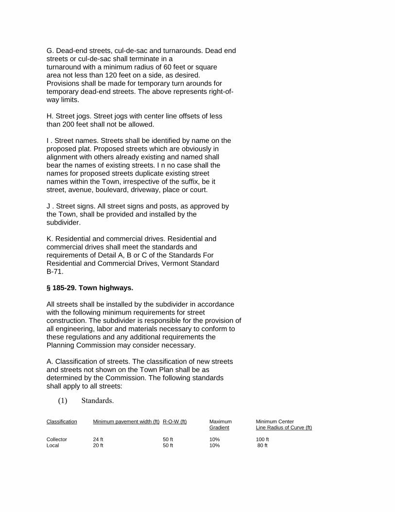
G. Dead-end streets, cul-de-sac and turnarounds. Dead end streets or cul-de-sac shall terminate in a turnaround with a minimum radius of 60 feet or square area not less than 120 feet on a side, as desired. Provisions shall be made for temporary turn arounds for temporary dead-end streets. The above represents right-of- way limits. H. Street jogs. Street jogs with center line offsets of less than 200 feet shall not be allowed. I . Street names. Streets shall be identified by name on the proposed plat. Proposed streets which are obviously in alignment with others already existing and named shall bear the names of existing streets. I n no case shall the names for proposed streets duplicate existing street names within the Town, irrespective of the suffix, be it street, avenue, boulevard, driveway, place or court. J . Street signs. All street signs and posts, as approved by the Town, shall be provided and installed by the subdivider. K. Residential and commercial drives. Residential and commercial drives shall meet the standards and requirements of Detail A, B or C of the Standards For Residential and Commercial Drives, Vermont Standard B-71. § 185-29. Town highways. All streets shall be installed by the subdivider in accordance with the following minimum requirements for street construction. The subdivider is responsible for the provision of all engineering, labor and materials necessary to conform to these regulations and any additional requirements the Planning Commission may consider necessary. A. Classification of streets. The classification of new streets and streets not shown on the Town Plan shall be as determined by the Commission. The following standards shall apply to all streets:
(1) Standards.
Classification Minimum pavement width (ft) R-O-W (ft) Maximum Minimum Center Gradient Line Radius of Curve (ft) Collector 24 ft 50 ft 10% 100 ft Local 20 ft 50 ft 10% 80 ft
(2) Typical cross section: road construction.
B. Greater right-of-way width. The Commission may require greater right-of-way widths where it is judged t h a t the demands of present or future traffic make it desirable or where topographic conditions necessitate greater width for grading. C. Gradient. The maximum gradient for all streets shall not exceed 10%, with the exception that the Commission may modify, with the compliance of the Select Board and Road Commissioner, the maximum and minimum gradient for short lengths of streets where, in its judgment, existing topographic conditions or the preservation of natural features indicate that such modification will result in the best subdivision of land. The minimum gradient shall allow positive drainage. D. Paving. All streets to be maintained by the Town shall be paved in accordance with the current State of Vermont Agency of Transportation Standard Specifications for Construction. E. Subbase. The road subbase shall consist of a minimum of 12 inches of clean run or bank gravel with no stones exceeding four inches in diameter. A minimum of three inches of crushed gravel shall be applied on the r u n of bank gravel base. F. Drainage. (1) For a roadway, there shall be an eighteen-inch galvanized metal pipe minimum with drop inlets or catch basins as required. (2) For drives, there shall be a twelve-inch galvanized metal pipe minimum. (3) For an underdrain there shall be a six-inch perforated, galvanized metal pipe as required. (4) Location, construction, depth and amount of drainage shall be in accordance with Vermont standards. G. Slopes. Guardrails with treated wood or steel posts shall be provided, plus two feet of shoulder, widening for fills over 10 feet with slopes of 1:2 or steeper. For slopes of 1:3
or flatter, no guardrail is required. Slopes are to be top soiled, seeded, fertilized and mulched in accordance with Vermont specifications. H. Town highway ordinance. In all instances, the Town highway ordinance shall govern. § 185-30. Access roads. A. I f the access road to the subdivision is a Class 4 road, the Commission shall require the subdivider to improve the access road to municipal highway construction standards. If in the Municipal Five-Year Highway Plan, the Class 4 road is not intended to be reclassified as Class 3, the subdivider must make arrangements for maintenance of the access road which are satisfactory to the Commission until such time as the legislative body may reclassify the road. B. The Commission may require the subdivider to improve any access road, where it intersects with new streets or driveways in the subdivision, to facilitate traffic circulation and pedestrian and vehicular safety. C. Access management. [Added 5-24-1999] (1) Streets, driveways, and intersections shall be designed and construction in conformance with the Roadway Policies established in the current Rutland Municipal Development Plan. (2) Exceptions to the requirement above may be granted only if it can be documented that such an exception would be consistent with the Municipal Development Plan and desirable to provide for continuity with streets, driveways, and intersections in adjoining subdivisions or developed areas. § 185-31. Pedestrians. Where necessary, in the judgment of the Commission, rights-of-way for pedestrian travel and access may be required to facilitate pedestrian circulation within the subdivision and to provide access to public property. § 185-32. Utilities. A. Utility lines. All electric, telephone, cable TV and outdoor lighting distribution lines shall be placed underground in accordance with utility company specifications. In areas of extremely shallow soils, the Planning
Commission may waive this requirement. The subdivider shall coordinate the design with the utility companies to ensure adequate and suitable areas for underground installation for the proposed subdivision and areas adjacent to the subdivision. § 185-32 SUBDIVISION OF LAND § 185-33 B. Extension of municipal utilities. All subdivisions shall make adequate provisions for water supply, storm water and sanitary sewage disposal and required utilities and improvements. Contingent on fire district approval, the Commission may require the extension of public waters and sewers to and within a proposed subdivision, without cost to the municipality, where existing lines are, in the judgment of the Commission, within a reasonable distance of the proposed subdivision. C. Connections to municipal utilities. Prior to paving, the subdivider shall install laterals from all utilities to the street property line of each building lot. Any residential building constructed in the subdivision shall have house connections installed and shall have such connections extended inside of the building. All such utility system installations shall be at the expense of the subdivider. D. Depth of utility mains. Water and sewer mains must be laid below the depth of frost penetration of the area. Sewer lines shall be set lower than water mains. E. Easements. A ten-foot-wide easement to accommodate public utilities shall be reserved along every road or such other reasonable and practicable places. Such easement shall be depicted upon the final plat. Every deed to a lot in the subdivision shall specifically exempt the easement interest from its operation. The easement area shall be deemed to be owned by the subdivider or the subdivider's heirs, successors and assigns and shall not be construed as increasing any setback distances in relation to the edge of the road right-of-way. § 185-33. Water A. For subdivisions which will connect to a public municipal water supply system, applications for extensions to the municipal system shall be approved by the officers arid agents of a municipality entrusted with the care and superintendence of a municipal water supply system. B. The Commission may require that community water supply system which is unconnected to municipal systems be designed in such a way that it may eventually be connected to a public municipal water supply system.
C. For subdivisions which will have individual water supplies, the subdivider shall provide evidence of the location and availability of potable water in adequate quantities. D. The following standards shall be met for those subdivisions which will have community water systems or individual water supplies: (1) Due consideration shall be given to the drainage patterns in the area. (2) Building sites and new roadways shall be located far enough away from underground water concentrations or surface areas which take in water to prevent runoff from roads or leachate from septic systems from contaminating water supplies. (3) Buildings and septic systems shall be located sufficiently above floodwater levels and high groundwater areas to prevent the pollution of surface water. § 185-34. Sewage disposal. A. For subdivisions which will connect to a municipal sewage disposal system, applications for extensions shall be approved by the officers and agents of a municipality entrusted with the care and superintendence of a municipal sewage disposal system. B. The Commission may require that community sewage disposal systems which are unconnected to municipal systems be designed in such a way that they may be connected eventually to a municipal sewage disposal system. Community sewage disposal systems shall meet the requirements of the municipal health regulations. C. Individual septic systems shall meet the requirements of the municipal health regulations and Vermont Health Regulations Chapter 5, Sanitary Engineering, Subchapter 10, Part III. D. Subdivisions using subsurface sewage disposal shall meet the following standards. (1) All subsurface sewage disposal systems shall be located at least one hundred (100) feet from a drilled well and one hundred fifty (150) feet from any other form of water supply. (2) All subsurface sewage disposal systems shall be located at least two hundred fifty (250) feet from a watercourse or standing body of water used as a source of public
drinking water. § 185-35. Storm water drainage. An adequate surface storm water drainage system for the entire subdivision area shall be provided. The subdivider may be required by the Commission to carry away by pipe or open ditch any spring- or surface water that may exist either previous to or as a result of the subdivisions. A culvert or other drainage facility shall, in each case, be large enough to accommodate potential runoff from its entire upstream drainage area, whether inside or outside the subdivision. Where it is anticipated that additional runoff incidental to the development of the subdivision will overload an existing downstream drainage facility so that there will be drainage to private property or an increase in the expenditure of public funds, the Commission shall not approve the subdivision until provision has been made for the improvement of said condition. Where a subdivision is traversed by a watercourse or drainage way, there shall be provided a storm water drainage easement of such width as to encompass the twenty-five year- flood area of such watercourse, which easement shall be indicated on the final plat. § 185-36. Recreation areas. A. Where a proposed park, playground or other recreation area is shown on the comprehensive plan to be located, in whole or in part, in a proposed subdivision, the Commission shall require that such area or areas be shown on said plat However, the area indicated on the plat shall not exceed fifteen percent (15%) of the total area of the plat B. If the Commission determines that there is no proposed park, playground or other recreation area in the Comprehensive Plan located in a proposed subdivision or if the Commission determines that such a proposed recreation area of adequate size cannot be suitably located in the proposed subdivision, the Commission shall require, as a condition to the approval of the plat a payment to the municipality of an amount to be determined by the Board of Selectmen. The payment shall be used by the municipality to serve the area in which the subdivision is located. Fees paid pursuant to this section shall be deposited in a special fund to be used for acquisition and development of park and recreational facilities. § 185-37. Schools. Where a subdivision will accommodate a total of more than one hundred (100) dwellings, the Commission may require the designation of necessary public school sites or a payment in lieu thereof. Prior to imposing a condition of school site dedication, the Commission shall contact the Board of Education of the school district(s) of which the
municipality is a part If a Board of Education declares an interest in a site within the proposed subdivision, the Commission shall require the subdivider to' set aside the site and to show such area on the plat If the Commission determines that there is no interest in a school site or that a school site cannot be suitably located within the proposed subdivision, the Commission may require, as a condition to the approval of such plat payment to the municipality of an amount to be determined by the legislative body. The payment shall be used by the municipality for the acquisition and development of school sites or capital improvements to school structures. § 185-38. Site preservation and improvements. A. Natural cover. Land shall be subdivided and improved in reasonable conformity with existing topography in order to minimize grading, cut and fill and to retain, insofar as possible, the natural contours, limit storm water runoff and conserve the natural cover and soil. After application for approval has been made to the Commission, no topsoil, sand or gravel shall be removed from the subdivision for any other purpose than to meet construction needs for that particular subdivision or to meet any requirements of these regulations. B. Shade trees. The Commission may require that suitable hardwood shade trees, such as sugar maple, norway maple, red maple, ash or oak, be planted along streets where trees do not exist. A l l trees shall measure at least ten (10) feet in height and at least two (2) inches in diameter measured at a point six (6) inches above finished grade level. C. Erosion and sediment control. The smallest practical area of land should be exposed at any one (1) time during development. Land should not be left exposed during the winter months. Where necessary, temporary vegetation and/or mulching and structural measures may be required by the Commission to protect areas exposed during the development. Sediment basins shall be installed and maintained during development to remove sediment from runoff water and from land undergoing development. D. Excavation and grading. The entire area of work shall be brought to the required lines and grades by excavation or filling. A minimum of four (4) inches of topsoil shall be provided to cover all finished slopes. All streets shall be graded from property line to property line to approved grade and cross section. The Commission may require the developer to submit evidence of boring and/or other soil investigations to determine the depth composition and stability of the subgrade within the road section. Materials for embankment shall be placed in successive horizontal layers not exceeding six (6) inches in depth. They shall be thoroughly compacted. The
Commission may require embankments to be planted with stabilizing shrub or ground cover and seeded with a deep root perennial grass to prevent erosion. § 185-39. Management organizations. When a development involves common ownership of community facilities, open spaces or other commonly held property, a management organization to operate and maintain these facilities shall be required by the Commission. A prospectus shall be submitted by the subdivider describing this organization, its financing and membership, which must meet the requirements of the Commission.