Subduction zone segmentation: The 2004 and 2005 Sumatran Earthquakes 1 Subduction zone segmentation and controls on earthquake rupture: The 2004 and 2005 Sumatra earthquakes Consortium Participants: University of Southampton (Lead institution): Timothy Henstock (Consortium PI), Lisa McNeill, Jon Bull, Simon Dean University of Oxford: Shamita Das, Philip England University of Cambridge: Frederik Tilmann, Penny Barton, Keith Priestley University of Liverpool: Andreas Rietbrock British Geological Survey: David Tappin National Oceanography Centre, Southampton: Douglas Masson, Russell Wynn Major International Collaborators: LIPI, Indonesia: Hery Harjono (Director of Research Center for Geotechnology), Haryadi Permana, Danny Natawidjaja BPPT, Indonesia: Yusuf Djajadihardja IPG Paris, France: Satish Singh, Paul Tapponnier, Francis Lucazeau California Institute of Technology, USA: Kerry Sieh, Jean-Philippe Avouac, Robert Clayton Oregon State University, USA: Chris Goldfinger IFM-GEOMAR, Germany: Heidrun Kopp Bundesanstalt fur Geowissenschaften und Rohstoffe (BGR), Germany: Christoph Gaedicke Indian Institute of Technology, Kharagpur, India: Supriyo Mitra 1. EXECUTIVE SUMMARY The segmentation of major fault systems controls earthquake magnitude and location, but the physical causes of segment boundaries, and their impact on earthquake rupture dynamics, are still poorly understood. The Indian Ocean earthquakes offer a rare opportunity to further our understanding of earthquake rupture, because of their size and unprecedented seismological dataset. We propose by a consortium approach to investigate two of the most significant segment boundaries of the Sumatran subduction fault system, using an integrated programme of marine and land-based geological and geophysical studies. This unique assembly of techniques will link the three-dimensional structure of the subduction zone and earthquake history to the dynamics of 2004 and 2005 earthquake ruptures. The key question addressed by this proposal is how do the properties of the earthquake-generating fault zone influence the generation and rupture propagation of such large earthquakes. In Sumatra we have, for the first time, the opportunity to generate a state-of-the-art slip distribution using modern recordings and modern tools to investigate in detail the seismogenic fault zone. We will be able to relate the major features of the rupture distributions to geophysical properties on the fault plane, which nobody has succeeded doing so far. Natural hazard assessment and mitigation is a key element of NERC research strategy and has been emphasised in the recently published Natural Hazard Working Group report following the 2004 Indonesian earthquake and tsunami. Specifically, the report concludes that hazard assessment is necessary to implement of an early warning system, that we must identify the threats and processes underpinning these hazards and that greater support is needed to improve scientific methods used to assess risk. 2. INTRODUCTION Fault systems are generally divided into roughly planar segments, distinguished from one another by spatial offsets or differences in strike or dip. Such segment boundaries have been called, respectively, ''inhomegeneous barriers'' and ''geometric barriers'' (Aki, 1979). The maximum size of an earthquake on a fault system is controlled by the degree to which the propagating rupture can cross the boundaries between such segments. Although control exerted by segment boundaries is well established phenomenologically (e.g. Spence, 1977, along the Aleutian arc; Ando, 1975 along the Nankai trough), the physical mechanisms whereby this control is exerted are still obscure. This lack of understanding of the role of segmentation in the extent and distribution of rupture during large earthquakes leaves a significant gap in our ability to assess seismic hazards of major fault systems worldwide. The goal of this study is to carry out a coherent set of geophysical observations in the source regions of the 2004 and 2005 great Sumatra earthquakes, in order: (i) to characterise the physical properties of the plate boundary between the surface and the nucleation depth of these earthquakes (~30-40 km), (ii) by linking these observations to high-precision analysis of the rupture dynamics of the earthquakes, to elucidate the link between the
Transcript
Subduction zone segmentation: The 2004 and 2005 Sumatran Earthquakes
1
Subduction zone segmentation and controls on ear thquake rupture: The 2004 and 2005 Sumatra ear thquakes
Consortium Participants: University of Southampton (Lead institution): Timothy Henstock (Consortium PI), Lisa McNeill, Jon Bull, Simon Dean University of Oxford: Shamita Das, Philip England University of Cambridge: Frederik Tilmann, Penny Barton, Keith Priestley University of Liverpool: Andreas Rietbrock British Geological Survey: David Tappin National Oceanography Centre, Southampton: Douglas Masson, Russell Wynn Major International Collaborators: LIPI, Indonesia: Hery Harjono (Director of Research Center for Geotechnology), Haryadi Permana, Danny Natawidjaja BPPT, Indonesia: Yusuf Djajadihardja IPG Paris, France: Satish Singh, Paul Tapponnier, Francis Lucazeau California Institute of Technology, USA: Kerry Sieh, Jean-Philippe Avouac, Robert Clayton Oregon State University, USA: Chris Goldfinger IFM-GEOMAR, Germany: Heidrun Kopp Bundesanstalt fur Geowissenschaften und Rohstoffe (BGR), Germany: Christoph Gaedicke Indian Institute of Technology, Kharagpur, India: Supriyo Mitra 1. EXECUTIVE SUMMARY
The segmentation of major fault systems controls earthquake magnitude and location, but the physical causes of segment boundaries, and their impact on earthquake rupture dynamics, are still poorly understood. The Indian Ocean earthquakes offer a rare opportunity to further our understanding of earthquake rupture, because of their size and unprecedented seismological dataset. We propose by a consortium approach to investigate two of the most significant segment boundaries of the Sumatran subduction fault system, using an integrated programme of marine and land-based geological and geophysical studies. This unique assembly of techniques will link the three-dimensional structure of the subduction zone and earthquake history to the dynamics of 2004 and 2005 earthquake ruptures. The key question addressed by this proposal is how do the properties of the earthquake-generating fault zone influence the generation and rupture propagation of such large earthquakes. In Sumatra we have, for the first time, the opportunity to generate a state-of-the-art slip distribution using modern recordings and modern tools to investigate in detail the seismogenic fault zone. We will be able to relate the major features of the rupture distributions to geophysical properties on the fault plane, which nobody has succeeded doing so far.
Natural hazard assessment and mitigation is a key element of NERC research strategy and has been emphasised in the recently published Natural Hazard Working Group report following the 2004 Indonesian earthquake and tsunami. Specifically, the report concludes that hazard assessment is necessary to implement of an early warning system, that we must identify the threats and processes underpinning these hazards and that greater support is needed to improve scientific methods used to assess risk. 2. INTRODUCTION
Fault systems are generally divided into roughly planar segments, distinguished from one another by spatial offsets or differences in strike or dip. Such segment boundaries have been called, respectively, ''inhomegeneous barriers'' and ''geometric barriers'' (Aki, 1979). The maximum size of an earthquake on a fault system is controlled by the degree to which the propagating rupture can cross the boundaries between such segments. Although control exerted by segment boundaries is well established phenomenologically (e.g. Spence, 1977, along the Aleutian arc; Ando, 1975 along the Nankai trough), the physical mechanisms whereby this control is exerted are still obscure. This lack of understanding of the role of segmentation in the extent and distribution of rupture during large earthquakes leaves a significant gap in our ability to assess seismic hazards of major fault systems worldwide. The goal of this study is to carry out a coherent set of geophysical observations in the source regions of the 2004 and 2005 great Sumatra earthquakes, in order: (i) to characterise the physical properties of the plate boundary between the surface and the nucleation depth of these earthquakes (~30-40 km), (ii) by linking these observations to high-precision analysis of the rupture dynamics of the earthquakes, to elucidate the link between the
Subduction zone segmentation: The 2004 and 2005 Sumatran Earthquakes
2
structure of the subduction zone and the dynamics of the earthquakes. The gap in understanding of earthquake dynamics is deepest for the greatest earthquakes, because they
occur the least frequently. The December 26th 2004 MW 9.3 earthquake (Stein and Okal, 2005) on the Sumatra subduction zone (Fig 1) was the largest earthquake within the past 40 years and the second-largest ever recorded. It was followed on March 28th 2005 by an MW 8.7 earthquake, which was the second-largest earthquake in the past 40 years. These earthquakes ruptured, respectively, 1200—1300 km and 300—400 km of the subduction boundary between the Indian-Australian plate and the Burman and Sumatra blocks. Rupture in the 2004 event started at the southern end of the fault segment, and propagated northwards. The observation that the slip did not propagate significantly southwards in December 2004, even though the magnitude of slip was high at the southern end of the rupture (Fig 2; Ammon et al., 2005, model A), strongly suggests a barrier at that place.
The proximity of a high-slip patch to this barrier, and the previous history of great earthquakes in the region (Figs. 1,2), discussed further below, indicated that the timing of an earthquake on the next segment to the south would be advanced. This was realized immediately by seismologists. Public attempts to raise awareness of this possibility included statements to the mass media (Das and Sieh, Feb 11, 2005, ITV News, and following days on CNN), and in scientific journals (McCloskey et al., 2005). Thus the
segmentation of the Sumatran subduction zone was already recognised as a key issue when the March 2005 great earthquake occurred. During the March 2005 earthquake, preliminary slip models show a slip maximum occurred within ~100 km of the barrier between the 200 4 and 2005 ruptures (Ammon et al., 2005), with rupture along a ~400 km fault segment, confirming both the physical importance of the barrier, and the loading of the March 2005 rupture zone by the December 2004 earthquake.
Among the many important issues raised by this pair of earthquakes are three key questions for the general understanding of earthquake dynamics and hazard: 1. What are the physical properties of a barrier that can so abruptly terminate rupture of the enormous magnitude of the 2004 event, despite the fact that the fault segment beyond the barrier was manifestly ready to slip, as the March 2005 event showed? 2. Is the surface manifestation of segmentation reflected in the structure of the subduction zone at depth? 3. Has the patch of the subduction thrust between the two great earthquakes completely ruptured, or does a slip deficit, which could amount to yet another great earthquake, still remain in this region?
These questions, and others to be discussed below, are not new (Spence, 1977; Aki, 1979; Scholz 2002). What makes this research timely is that the 2004 and 2005 earthquakes are, by some margin, the two largest subduction zone earthquakes since the advent of high resolution modern geophysical tools and therefore present the
Figure 1. Regional setting of the Sumatra subduction zone. Approximate mainshock rupture extents and the first ten days of aftershocks with M>5 are shown in red (26/12/04) and orange (28/3/05) respectively, with Harvard CMT solutions. Hatching – estimated extent of major previous earthquakes, cross-hatched where constrained by coral uplift. Grey shading - HMS Scott bathymetry coverage. Blue squares – location of new permanent seismic stations. Elevation contoured at 1000m intervals. Active arc volcanoes also marked.
Subduction zone segmentation: The 2004 and 2005 Sumatran Earthquakes
3
first opportunity to apply and refine these tools to further our understanding of earthquake dynamics and the tectonic processes driving them. The history of earthquake activity along the Sumatran subduction zone points to additional urgency. Historical records show a sequence of great earthquakes (Fig. 1) clustered in the interval 1797—1861 (e.g., Newcomb and McCann, 1987; Sieh et al., 2004); the 1861 event overlapped the 2005 rupture area, but two great earthquakes took place in 1797 and 1833 on the same section of the subduction zone to the south of the 2005 rupture. Stress has now been transferred onto this region (Nalbant et al, 2005), bringing it closer to failure.
The results of this research will be generally applicable to the dynamics of large earthquakes, and will have particular relevance to hazard associated with the southern portion of the Sumatran subduction zone which, if the pattern of the nineteenth century is followed, is likely to experience a great earthquake in the next few years or decades. Most of the world’s great (MW>8) earthquakes occur in subduction zones, where the hazard of tsunamis is added to that due to shaking and the recent Sumatran earthquakes have focussed international attention almost exclusively on the threat posed by subduction-zone earthquakes and tsunamis. These hazards are particularly significant in high population coastal regions where earthquakes are thought to be overdue, such as Tokyo, Japan and the Cascadia margin, western USA. Seismic hazards of equal, or perhaps greater, magnitude are posed by the major thrust faults along the Himalayan arc, where immense concentrations of population have sprung up since the last sequence of great earthquakes, and where literally millions of lives could be lost in the next sequence (Bilham, 2004a, b). Because the major thrust faults bounding the Himalaya are a subduction zone in all but name, the research proposed here will also be of great relevance to this major zone of seismic hazard. Segmentation and Earthquake History of the Northern Sumatran Subduction Zone
Although we may never be able to make precise prediction of the timing and slip distribution of future earthquakes, we can make significant progress in assessment of associated hazards. We focus in this proposal on the segmentation and earthquake history of the Sumatran subduction zone and the relationship between them but we strongly expect that, by exploring in depth this major subduction zone, we shall obtain other insights that are impossible to foresee at present. Segmentation
It is essential to understand the role of segmentation in the Sumatran subduction zone for two reasons. First, segmentation controls the extent of slip, and thus the magnitude, of an earthquake. Secondly, as has
frequently been observed, and as inversions of the slip history of the December 2004 earthquake vividly demonstrate (Fig 2), there can be strong lateral variability in the amount of slip that takes place during an earthquake and this variability can be linked to difference in coupling strength due to topography on the plate interface, compositional heterogeneity or varying effective pressure due to pore pressure variations. Regions of high slip, often referred to as asperities (a term that we shall avoid because it is used with more than one sense in the literature), are often also regions of high slip rate and stress change and thus are the source of the greatest shaking in earthquakes.
Several types of tectonic feature are plausibly related to segmentation. These include: discontinuities in the geometry of the subducting plate such as slab tears (e.g. Spence, 1977; Aki, 1979); topographic anomalies within the subducting plate, such as ridges, fracture zones and seamount chains (e.g., Cummins et al., 2002; Kodaira et al., 2002; Bilek et al., 2003; Collot et al., 2004), major structures crossing the overriding plate (Sugiyama, 1992; Ryan and Scholl, 1993; Collot et al., 2004) and large scale
Figure 2. Fault slip for the 26 December, 2004 Sumatra earthquake, 168 s after rupture initiation, obtained by inverting SH body waves (Ammon et al., 2005). Active volcanoes are shown as black triangles.
Subduction zone segmentation: The 2004 and 2005 Sumatran Earthquakes
4
variations in the buoyancy of the subducting plate related primarily to its thermal age (Yanez and Cembrano, 2004). This heterogeneity in properties of the overlying and subducting plates should be measurable as variations in temperature, rock strength, composition, stress state, fluid content, and by geometry of large scale structure.
Studies of other subduction zones, in particular the Nankai trough and Japan Trench, but also the Middle American and Andean trenches (e.g., Collot et al., 2004) show that such features can successfully be imaged and linked to earthquake slip by the seismic and seismological techniques to be employed here. Distribution and geometry of these heterogeneities can be determined by large scale seismic imaging and tomography experiments, heat flow measurements and earthquake location. For example, detailed seismic imaging of the source region of the 1946 Nankaido earthquake (Kodaira et al., 2000; 2002) and waveform analysis (Cummins et al., 2002) revealed strong lateral variation in physical properties of the subduction interface in a part of the fault that had low slip during the earthquake; this region is interpreted as a zone of high pore-fluid pressure associated with the top of a subducted seamount, confirming distinctive slip behaviour between different fault segments. A similar marine seismic study of the rupture zones of the 1968 and 1994 Japan Trench plate boundary earthquakes (Hayakawa et al., 2002) revealed structural heterogeneity in P-wave velocities at the termination of earthquake rupture. Variations in wave speed and Moho depth across this boundary may be related to high fluid pressure or serpentinisation associated with subducted seamounts. Though significant, these previous studies have focused on one cause of segmentation (seamount subduction) and do not address other forms of physical barrier, but most importantly lack the unique seismological dataset available following the Sumatran earthquakes to link earthquake dynamics with physical properties. For example, is the variation in fluids (e.g., Bangs et al., 2004) a more important factor than structural geometry in influencing rupture dynamics?
The size and tsunamigenic potential of subduction zone earthquakes within any given segment is controlled by the width and position of the seismogenic zone. Temperature and water are the two factors thought to exert the main control on the depth limits of unstable sliding, i.e. the portion of the fault capable of causing great earthquakes. The updip limit is controlled by either phase transitions in clay minerals at 100-150°C (Hyndman et al., 1997), or by a drop in pore fluid pressure due to the completion of dehydration reactions in the sediments (Moore and Saffer, 2001). The downdip limit for older plates is generally thought to coincide with the intersection of the plate interface with the continental Moho, except for subduction of very young oceanic plates, as the mantle wedge becomes serpentinised by water released from the dehydration reactions in the downgoing slab (Hyndman et al. 1997). However, subduction in Sumatra does not seem to conform to this concept: Simoes et al. (2004) argue from geodetic and coral data collected on the Batu islands and adjacent Sumatran coast that the plate is locked to 10 km below the continental Moho; there is only limited geophysical data available, therefore constraints on Moho depths are weak. It is also an open question whether segment boundaries coinicide with significant differences in the updip and downdip depth limits of locking. Earthquake History of the Northern Sumatran Subduction Zone
Earthquake history at convergent plate boundaries is often poorly known as historic records are short and geologic records sparse such that the relationship between earthquake recurrence on different segments of the fault system is not well constrained. Repeat times of earthquakes on segments of the Sumatran subduction zone are thought to average ~150-500 years. Deviations from this average are evident from recent events (e.g., the 1797 and 1833 closely-spaced temporal couplet; Sieh et al., 2004) but no long-term record has yet been produced to assess such variations. Earthquake sequences are common along major segmented fault zones (e.g., North Anatolian Fault; Parsons et al., 2000) and this behaviour may also apply to parts of the Sumatran subduction zone (e.g., 1797/1833-1861 and 2004-2005 sequences).
Historic records provide an insight into earthquake frequency and magnitude over a few hundred years in Sumatra (Fig 1, e.g., Newcomb and McCann, 1987; Ortiz and Bilham, 2003). This historic record is extended significantly back in time by geological records: Corals at forearc islands record vertical tectonic motions during subduction earthquakes and can be accurately dated (e.g., Sieh et al., 1999; Natawidjaja et al., 2004). These records have constrained likely magnitudes through modelling of the 1797/1833 event to the south of the 2005 rupture zone (Natawidjaja et al., 2004; Sieh et al., 2004) and work is ongoing in the possibly coincident 1861 and 2005 rupture zones. However these records are limited to the few land areas of the forearc and invariably cannot constrain rupture lengths and therefore
Subduction zone segmentation: The 2004 and 2005 Sumatran Earthquakes
5
the impact of segment boundaries on earthquake rupture. Although limited spatially and temporally, these records do show some initial correlation with possible
segmentation of the Sumatran fault system which requires further investigation, but it is unclear whether these proposed segment boundaries persist over longer time periods and multiple earthquake cycles. When do these barriers stop earthquake propagation and when are they ruptured and why? Are sequences of earthquakes along the margin related to preceding earthquakes and state of stress or due primarily to the physical properties and structure of the plate boundary? The southern termination of the 2004 earthquake and northern termination of the 2005 earthquake appear to coincide at the island of Simeuleu (Fig 1) although a minor seismic gap between the events that could locally pose a potential future hazard cannot be excluded with current data. This boundary is also marked by a major change in margin structure and morphology (Fig 3, forearc width and topography, plate boundary position, etc), but in spite of this no clear origin of segmentation is observed in the incoming Indian plate, despite common N-S oceanic fracture zones. To the south, the 2005 earthquake terminated between Nias and Siberut islands (Fig 1) and may also coincide with terminations of the 1861 and 1833 earthquakes (Zachariasen et al., 1999). Transverse forearc structures and the subducting Investigator fracture zone may be related to this boundary. Prawirodirdjo et al. (1997) noted a lateral variation in geodetically-measured interseimic velocity here and inferred a variation in plate coupling related to varying fluid pressure as a result of different sediment input. These two boundaries represent the chosen study areas of the proposed project.
The HMS Scott bathymetric data (see Experimental Programme) and proposed programme of marine sediment cores to interpret long-term earthquake history (as applied on the Cascadia margin, Goldfinger et al., 2003), in conjunction with geophysical constraints on structure and properties, will allow many of these questions to be addressed by linking earthquake rupture history to margin segmentation. 3. OBJECTIVES
Our overarching objective is to address how segment boundaries in subduction zone systems control the propagation and extent of rupture in earthquakes on plate boundaries. Towards this goal, we shall conduct an extensive marine geological and geophysical programme combined with an onshore seismic experiment at the southern boundaries to the Dec. 2004 and Mar. 2005 Sumatran earthquakes. Results from these experiments will be integrated with fault slip and aftershock distribution determined from seismological data of the 2004 and 2005 great earthquakes, and with geodynamical modelling, to obtain a unified picture of the dynamics of this crucial section of the plate boundary.
The rationale for selecting and background to these two segment boundaries for study was given above. The two boundaries also represent different styles of surface morphology and possibly the underlying cause of segmentation, providing a unique opportunity to relate the surficial features to deeper structure along the fault:
Segment Boundary 1 (SB1): Between the 2004 and 2005 earthquakes at Simeuleu island (Figs. 1, 3). Segment Boundary 2 (SB2): Located at the southern termination of the 2005 earthquake close to Nias
and the Batu-Pini islands (Figs. 1, 3). Our principal objectives are: 1. To produce multi-scale structural models (physical properties and geometry) of the Sumatran
subduction zone at the boundaries to the 2004 and 2005 great earthquakes, by using a combination of geological and geophysical techniques: integrating surface morphology, seismic reflection and refraction, heat flux and earthquake source components. These observations address the fundamental questions of what controls the location of these segment boundaries: are their locations associated with changes in the plate interface geometry and physical properties, are they controlled by structures in the subducting plate such as the Investigator fracture zone near SB2 (Sieh & Natawidjaja, 2000; Fauzi et al., 1996), or is the structure of the overriding plate important? Are stress variations related to these geometrical features, or does the thermal state of the subduction boundary and the mantle wedge control the distribution of slip?
2. To understand links between surface morphology and smaller scale structure with the deeper large scale structure driving earthquake rupture. Segmentation of faults at many scales is easily seen on the surface, but is this segmentation purely a surficial feature or does it link to variations in properties at depth? Morphological studies – even at sea – are much less expensive than exploration of fault zones at depth; on land, the costs differ by many orders of magnitude and, in most parts of the developing world, identification of fault segmentation from surface morphology is the only affordable technique. If such surface studies are to help us to understand the mechanics of major fault systems and associated hazards, surface segmentation must be unequivocally linked to structure at depth. The tools combined here (from
Subduction zone segmentation: The 2004 and 2005 Sumatran Earthquakes
6
shallow-to-deep exploration, together with studies of earthquake dynamics by inversion of seismograms and earthquake history from sediment cores) will allow us to attack this problem with a resolution that has previously been impossible. An important aspect of this objective is to correlate earthquake slip at depth with seafloor deformation; a more accurate picture of the distribution of near-surface motion during the earthquakes will help to place constraints on physical models of tsunamis.
3. To use relocations of aftershocks and microseismicity to estimate the position and dip-extent of the seismogenic zone, shape of the active plate boundary and other major fault structures. These studies will allow us to extend the knowledge of the subduction interface obtained from detailed geophysical surveys to address on a larger scale, questions such as: Where do the updip and downdip limits of the seismogenic part of the plate boundary lie with respect to the corner of the mantle wedge and to predicted temperatures at the plate interface? Is the downdip limit of the seismogenic part of the plate boundary related to petrological contrasts, such as the location of the continental Moho within the overriding plate, phase changes or reactions at the top of the slab, or serpentinisation of the mantle wedge?
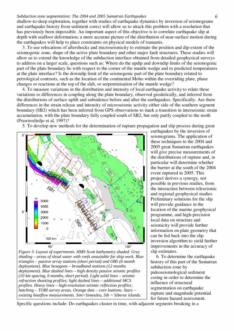
4. To measure variations in the distribution and intensity of local earthquake activity to relate these variations to differences in coupling along the plate boundary, observed geodetically, and inferred from the distributions of surface uplift and subsidence before and after the earthquakes. Specifically: Are there differences in the strain release and intensity of microseismic activity either side of the southern segment boundary (SB2) which has been inferred from GPS observations to mark a transition in interseismic strain accumulation, with the plate boundary fully coupled south of SB2, but only partly coupled to the north (Prawirodirdjo et al, 1997)?
5. To develop new methods for the determination of rupture propagation and slip process during great earthquakes by the inversion of seismograms. The application of these techniques to the 2004 and 2005 great Sumatran earthquakes will give precise measurements of the distributions of rupture and, in particular will determine whether the barrier at the south of the 2004 event ruptured in 2005. This project derives a synergy, not possible in previous studies, from the interaction between teleseismic and regional geophysical studies. Preliminary solutions for the slip will provide guidance in the location of the marine geophysical programme, and high-precision local data on structure and seismicity will provide further information on plate geometry that can be fed back into the slip inversion algorithm to yield further improvements in the accuracy of slip estimates.
6. To determine the earthquake history of this part of the Sumatran subduction zone by paleoseismological sediment coring in order to determine the influence of structural segmentation on earthquake rupture and magnitude potential for future hazard assessment.
Specific questions include: Do earthquakes cluster in time, with adjacent segments breaking in a
Figure 3. Layout of experiments. HMS Scott bathymetry shaded. Grey shading – areas of shoal water with reefs unsuitable for ship work. Blue triangles – passive array stations (short period) and OBS (6 month deployment). Blue hexagons – broadband stations (12 months deployment). Blue dashed lines – high density passive seismic profiles (10 km spacing, 6 months, short period). Light solid lines – seismic refraction shooting profiles; light dashed lines – additional MCS profiles. Heavy lines – high-resolution seismic reflection profiles; hatching – TOBI survey areas. Orange dots – core loations. Stars – existing heatflow measurements. Sim=Simeuleu, Sib = Siberut islands.
Subduction zone segmentation: The 2004 and 2005 Sumatran Earthquakes
7
predictable sequence as suggested by simple stress triggering considerations, or with some segments rupturing more frequently than average recurrence intervals? Do earthquakes regularly terminate at the same physical barriers, and, how frequent are earthquakes rupturing across such barriers to cause extremely large events such as the 2004 earthquake?
7. To apply the understanding derived in the present study to assessment of other subduction zones and fault systems with large earthquake potential. Improved physical understanding based on analysis of the 2004/5 events will not only enable us to assess the likely distribution of slip in future earthquakes on this zone; the general knowledge of the role of segmentation in earthquake hazard can also be transferred to other subduction systems with large seismic potential near population centres, for example Japan, Northwestern US and Peru. The broad combination of disciplines that we have assembled is unique, and is the only way to address this problem fully.
These scientific objectives will be addressed with an interdisciplinary experimental programme of
three cruises and a temporary land and marine seismic array deployment. In addition, we will use earthquake data recorded on the Global Seismic Network, on an Indian regional array and on permanent regional stations that are expected to be installed over the period of this work. Different aspects of this large dataset will be analysed by the 4 Workgroups, with regular meetings and exchanges of results, as well as overlap of personnel. Such an interdisciplinary approach is required so that we can understand the working of the subduction zone across the required range of depth and length scales, from the mantle wedge to seafloor rupture. The comparison of fault slip inversion with structure, tying the dynamics of the system during major earthquakes to variations in material properties, has not been possible previously, and requires each of the workgroup activities to be successfully completed. Our consortium brings together a diverse group of geophysicists and geologists to tackle a complex problem, many of whom have not worked together before in terms of both personnel and discipline (e.g., sedimentologists and seismic tomographers). The junior researchers involved (post-doctoral and PhD) will also benefit from this multidisciplinary nature and research diversity. A large number of international collaborators (from France, Germany, Indonesia, USA) have expressed enthusiasm in joining this dynamic consortium of UK-based collaborators (see letters of collaboration and details below). We stress that this study is unique amongst other programmes by focussing on segmentation and earthquake rupture, but data from collaborators on these broader complementary programmes will enhance the proposed research. 4. EXPERIMENTAL PROGRAMME HMS Scott Bathymetry Survey
High-resolution swath bathymetry data were collected during Jan-Feb 2005 by the HMS Scott - in which Henstock, McNeill and Tappin acted as scientific advisers - over the southern 400km of the 2004 rupture zone (Figs 3-5; Henstock et al, submitted). The data show segmentation of the subduction zone on two main scales: Major segmentation is overall larger than the survey region, but SB1 is encompassed within the survey. The youngest linear folds at the toe of the accretionary prism, with wavelengths of 5-10km and heights of 0.5-1km, are segmented on a scale of 10-80km; changes in trend of these folds to accommodate the overall shape of the subduction zone suggest that the same is true of the underlying faults. These scales are tantalising similar to features in the earthquake slip distribution (Fig 2). In addition, near the deformation front, smaller neotectonic features at the limit of resolution of the system – small folds and scarps 5-50m in height – are of a scale that
they may represent direct transfer of slip from a few great earthquakes to the seafloor. Data collected across the accretionary wedge shows that an unfilled forearc basin prevents the formation of large canyon
Figure 4. Frontal thrust segmentation near SB1 (HMS Scott data). Stepping fold-thrust fault segments (10-80 km length) accommodate change in trend of plate boundary. Targets of high resolution seismic reflection profiles across fold-thrust segments are shown. TOBI sidescan tracklines are shown along the prism toe with coverage of the frontal ridges, including possible seafloor rupture features at the deformation front.
Subduction zone segmentation: The 2004 and 2005 Sumatran Earthquakes
8
systems near SB1 which could transport terrestrial material to the deformation front, but that there are localised short channels on the abyssal plain, lowermost slopes, and in small basins within the accretionary prism. From other perspectives the new bathymetry shows that existing data are not only sparse, but also poorly positioned, so that swath data must be collected as an integral part of this project. An additional survey on HMS Scott has been requested for 2006 to cover the 2005 rupture zone. Cruise 1 (Figure 3). 39 days on station. Henstock (Chief Scientist) + 7 others
Cruise 1 will use a large airgun array (8000 in3) as a seismic source to be recorded simultaneously into the NERC 96 channel 2.4km hydrophone streamer, an array of 50 Ocean Bottom Seismometers (OBS) deployed at each segment boundary, and stations from our land experiment. Such sources have been successfully used in other similar experiments. Our tracklines at SB1 and SB2 (Fig 3) take into account shallows with reported reefs where research ship activities are not possible. We require 8 days for each OBS deployment/recovery (16 days total), 2 days for airgun and streamer handling, and 8 days shooting at each location (16 days total). We then allow 3 days to collect additional swath bathymetry data and prepare the long-deployment OBS followed by 2 days to redeploy the OBS. We anticipate recording up to 100GB of seismic reflection data and 400GB of seismic refraction data. Cruise 2 (Figures 3, 4, 5). 33 days on station. McNeill (CS) + 7 others
Cruise 2 will collect geophysical data focussing on the smaller features and smaller scales of segmentation. We plan high-resolution seismic reflection profiles using a small airgun source and short streamer to image the shallow structures underlying the fold segments (4 days SB1, 4 days SB2). TOBI will be used to collect 30kHz deep-towed sidescan sonar, microbathymetry, and sub-bottom profiler data (6 days SB1, 6 days SB2). Piston, Kasten and box coring with USBL transponder will be used to collect cores for paleoseismology studies (5 days SB1, 5 days SB2). Finally we allow 3 days for transits between the study areas, contingency and to collect additional swath data as required. One school teacher will participate as part of the Classroom at Sea programme (see Dissemination and Outreach). Cruise 3 (Figure 3). 22 days on station. Barton (CS) + 7 others (includes French for heat flow)
Cruise 3 will collect heat flow data (collaborator Lucazeau) along a transect at each of SB1 and SB2 coincident with one of the seismic refraction profiles (Fig. 3). Each 200km transect will require approximately 7 days to make measurements at 1.5km intervals (14 days total). During this cruise we also plan to recover the long term OBS (5 days required), hence it should be scheduled approximately 6 months after Cruise 1. We allow 3 additional days for transits, contingency, and improving swath bathymetry coverage. Long-term OBS recording
9 OBS with differential pressure gauges, including 3 broadband instruments (collaborator Singh), will be deployed at SB2 for 6 months between Cruises 1 and 3. The array (Fig 3) is designed to supplement the land experiment and extend the coverage of earthquake recording to the trench. Over this period, each instrument will record up to 31GB data (280GB total). Land Experiment (see Figure 3). Tilmann (CS), Cambridge PDRA + 2 others
Our long-term land seismic experiment will focus on SB2. SB1 will have good earthquake data from a 6 month deployment of ocean bottom seismometers planned for late 2005 by a German group (see letter of collaboration), likely to be supplemented with a land deployment by Tilmann and a CalTech station on Simeuleu. A subset of the land instruments will be deployed temporarily during Cruise 1 around SB1 to supplement our OBS recording of airgun shots, extending ray coverage to greater depths below the forearc. To achieve the scientific objectives the passive seismic array has two different requirements: Areal coverage to precisely locate earthquakes, optimise tomography, and determine focal mechanisms; Dense sampling of the wavefield to enable effective imaging of discontinuities from teleseismic arrivals. A station spacing of 10 km will properly sample the wavefield from a teleseismic P arrival at 40° distance with a 2 s period. Dense station spacings can only be achieved along profiles, so we will mix profiles with 10km station spacing and distributed sites (Fig 3), using 70 short period instruments (CMG-6T) recording for 6 months and 10 broadband instruments (CMG-3T) recording for 12 months; up to 1TB total data is expected in total. Two lines perpendicular to the trench allow resolution of the subduction zone structure, as well as features of the dextral onshore Sumatran fault system. The trench-parallel line allows a detailed resolution of SB2, and crosses the extension of the Investigator fracture zone. 5. WORKGROUPS (WG) WORK GROUP 1: Forearc Structure and Earthquake History. Personnel: McNeill (Leader-Southampton), Henstock, Bull, Masson, Wynn, Tappin, PDRA
Subduction zone segmentation: The 2004 and 2005 Sumatran Earthquakes
9
(Southampton), Goldfinger, Sieh, Natawidjaja We will investigate forearc and plate boundary structure at several different scales using seismic and sonar data recorded on Cruises 1 and 2. Large scale structure will be investigated using conventional 2D seismic reflection transects at the two segment boundaries (Cruise 1). Detailed structural segmentation and geometry of features near the deformation front will be resolved through high resolution seismic reflection and sidescan sonar of the active structures at the toe of the accretionary prism (Cruise 2). Sediment cores recording evidence of earthquake-triggered turbidity currents (submarine paleoseismology, Cruise 2), will be used to test the behaviour of segment boundaries over multiple earthquake cycles. 1. Large scale fault and accretionary wedge structure (Objective 1) We will use the 2D seismic reflection transects across the margin at the two segment boundaries (Cruise 1, Fig 3) to resolve large scale forearc and plate boundary structure. The structure of the main plate boundary and shallower faults within the accretionary prism, outer arc high and forearc basin will be imaged along these 40-50 km spaced transects, with emphasis on changes in structural geometry through and across the segment boundaries; the outer accretionary wedge will be imaged more densely (20-25km spacing) to link to high-resolution seismic data. Fault geometry linked to seafloor morphology will reveal the extent of lateral fault motion within the forearc, which is key to understanding strain partitioning within this obliquely convergent margin (Sieh and Natawidjaja, 2000). We will process the data initially as time-sections using post-stack migration, but expect that selected parts of the data will benefit from using pre-stack depth migration, available at Southampton (PDRA). Processing will be optimised to retain amplitude information which may indicate variations in the physical properties of the plate boundary zone, including pore pressures and the presence of fluids (e.g., Bangs et al., 2005). 2. Small-scale segmentation and coseismic slip (Objective 2)
We will determine how the faults controlling the segmented active thrust folds (Figs 3, 4, 5) at the toe of the accretionary prism link to one another and to the main plate boundary at depth using high-resolution seismic profiles at 6-20km spacing; TOBI data will be used to relate features between the seismic profiles. At SB1 we have used the Scott dataset to position profiles to image the centre of segments, together with the tips and step-over zones (Figs 3, 4); we will do the same at SB2 once detailed bathymetry is available. Understanding how these fault systems are linked and how surface morphology relates to deeper structure is essential to be able in future to rapidly assess the structure of other margins.
From the sidescan data and microbathymetry we will determine the presence of and variations in neotectonic fault scarps that are poorly resolved from surface bathymetry which may be linked to coseismic seafloor rupture during great earthquakes. The scarp observations will be compared with the segmentation and with the plate boundary slip determined by WG2, ultimately feeding into tsunami initiation models. Sidescan sonar will also image carbonate precipitates from methanogenic cold seeps
(e.g., Goldfinger et al., 1997) if present and provide direct evidence for linkage between active faulting and fluid flow.
Figure 5. Channel systems fed by local slope failure onto abyssal plain (HMS Scott data). (A) At 2.5°N, (B) offshore Simeuleu Island at SB1 between the 2004 and 2005 ruptures. Possible core locations for earthquake-triggered turbidites are shown.
Subduction zone segmentation: The 2004 and 2005 Sumatran Earthquakes
10
3. Submarine Paleoseismology (Objective 6) We will assess regional earthquake frequency and test whether fault segments have different earthquake histories by coring earthquake-triggered turbidites in submarine channel-canyon systems; this method has been successfully applied to several fault systems including the Cascadia subduction zone constraining temporal clustering and segmentation (e.g., Goldfinger et al., 2003; Shiki et al., 2000). Near SB1, the Scott data confirm that there are suitable channels (see Experimental Programme, Fig 5). Since these are localised other causes of deep-sea turbidity currents (e.g., storm, wave loading) can be eliminated and the sediment transport systems should reflect more accurately local shaking patterns. Previous studies suggest that these records will reflect Mw>7 events. Cores from Cascadia of 1-8 m have produced records of 3-10 ka and sedimentation rates are thought to be lower at this location. We will use a combination of coring methods to ensure that we collect precisely located cores yielding a record of multiple earthquake cycles; we expect earthquakes of M>8 to have average repeat times of ~150-500 years. Targets within channels are at least 200x200 m area and accurate core placement should be achievable; we will avoid regions of excessive erosion (partial record) and deposition (shorter records) as well as coarser grained sediment identified from sidescan, and use channel terraces where these are present. Cores will be split onboard and examined visually, followed by post-cruise physical property analysis (Multi-Sensor Core Logging, BOSCORF, Southampton). We will use AMS radiocarbon dating of planktonic forams immediately below (assuming minimal erosion) or above the turbidite layer; cores available from the NGDC database indicate foram abundance. The regional CCD at this latitude is similar to but slightly greater than the maximum depth of the abyssal plain (~4700-5100 m, Schulte and Bard, 2003); should forams be found to be rare in cores from the deep prism toe and abyssal plain channels, we will also sample channels in the shallower (~3000m) basins and forearc basin. To demonstrate whether earthquakes relate to particular fault segments, we will sample at least 150 km to either side of SB1 and SB2. A total of ~30 cores will be collected (coverage in Fig 3 with more specific examples in Fig 5), and up to 150 samples selected for dating. The records will allow testing of the hypothesis of earthquake clustering in the section of the margin containing the 2005, 1861, 1833 and 1797 events (Sieh et al., 2004; collaborator). Despite potential errors in radiocarbon dates preventing distinction of earthquakes closely spaced in time, major differences in event frequency in and between segments will be distinguishable, constraining relative magnitudes and likely frequencies of very large events such as the 2004 earthquake. Goldfinger’s collaboration brings invaluable experience from the western US margin and a funded complementary program of coring in different parts of the lengthy Sumatran margin. The French IPGP/Ifremer and German BGR/Geomar groups also plan minor paleoseismological coring programmes but will focus on other parts of the margin. Detailed coring locations for all these funded programmes are currently based on the Scott bathymetric data collected by McNeill, Henstock and Tappin. WORK GROUP 2: Earthquake slip models and aftershock sequences: Development and application of new methods. Personnel: Das (Leader), Priestley, England, PDRA (named staff – Robinson, Oxford), Mitra, Sieh, Natawidjaja 1. Robust determination of the co-seismic slip and associated stress changes for the 26 December 2004 and the 28 March 2005 great Sumatra earthquakes (Objectives 5, 2)
In order to relate segmentation and segment boundaries to the slip in the great Sumatran earthquakes, we need reliable knowledge of the slip distribution and rupturing history on the fault. Towards this end, we propose to obtain robust estimates of the slip histories over the fault area for these two earthquakes, the largest and the second largest since 1964. In general, our results will relate the distribution of slip to structural features of the plate boundary zone, and to the distribution of aftershocks; in particular, our method of testing to find the boundaries of the region of slip will provide input on whether the segmentation barrier at the southern end of the 2004 earthquake broke in 2005 or whether there is still a substantial short-term seismic hazard in that region.
Recent publications on the 2004 earthquake (Fig 2; Ammon et al., 2005; Ishii et al., 2005; Krueger and Ohrnberger, 2005) show that current methods of solving for slip distribution each needed to make some compromise to study this earthquake. These compromises required filtering of the data to frequencies where later unmodelled phases (e.g. core reflections multiple phases) are not significant, thereby losing the information at many periods; terminating the seismograms when such phases arrive and thereby studying only the earlier part of the rupture process; limiting the slip process to the vicinity of the main
Subduction zone segmentation: The 2004 and 2005 Sumatran Earthquakes
11
rupture front thereby obtaining lower slip near the hypocentre, and so on. Resulting slip estimates differed significantly depending on the choices made. Hence, a method which does not have these drawbacks must be developed.
Our starting point will be use of the method of Das and Kostrov (1990; 1994) in which body waves are inverted to obtain details of the slip and rupture history over the fault. The method involves the solution of a system of equations Ax ~ b, where x is the vector of unknown fault slip rates at each grid and at each time step, b is the vector of the digitally recorded seismograms, and the matrix A is the impulse response of the Earth medium (the Green's function) and depends on the Earth structure. Additional physically based conditions such as causality, and not allowing the fault to slip backwards (“positivity''), are used to improve the solution’s stability. The positivity constraint means that the system of equations cannot be solved using the usual least-squares method, and we use the method of linear programming to minimise the L1-norm of the vector of residuals r = b - Ax, as this is more robust than other norms. Additional levels of optimization looking for, e.g., the smoothest solution that fits the data, will also be conducted.
This method has been thoroughly tested and applied to earthquakes up to Mw 8.4, and for rupture lengths <500 km (Henry et al., 2000; Robinson et al., 2001; Henry, 2002; Henry and Das, 2002). However, to study the unusually large Sumatran earthquakes, particularly the 26/12/04 earthquake with rupture length >1000 km, the method needs to be modified and extended, and then properly tested (as was done in the 4 previous references, using synthetic data, and by Das and Suhadolc, 1996; Das et al., 1996).
We propose to use the method of Empirical Green's Functions (EGF) in which waveforms from aftershocks are used to generate the Green’s function matrix A. These aftershock-Green’s functions will correctly give the Earth response for long time intervals, including the time-windows containing multiple phases and core-reflections. All the limitations discussed above will be removed by this modification. We shall invert both the shorter period (2-120s) waves and longer period (150-3500s) waves simultaneously, in order to account properly for the behaviour of the source at different scale lengths. This modification is essential because the size of great earthquakes means that it is inappropriate to use the seismic moment determined only from the long period waves as a constraint (e.g., the CMT solution), as this moment is appropriate only for a point source and chosen depth. The PDRA and Das will implement these modifications, working with the Woodhouse group at Oxford to use their great experience on fitting the very long period waves.
This kind of multi-level optimization accompanied by thorough testing is a unique feature of our work, and though it is a very time-consuming step, it is essential for reliable information on the slip distribution on the fault. The importance of this step cannot be over-emphasized as such slip distributions are used to infer stress changes around the fault, for identifying regions most likely to slip in the future, and as input into tsunami models. The stress change is related to the slip distribution on the fault (which is highly variable over the fault) through an integral equation (Kostrov and Das, 1988; Aki and Richards, 2002) and we shall solve this equation to determine both the dynamic and the static stress changes due to the earthquakes, on and around the fault. The necessary programs for this will be implemented by the PDRA, with the help of Das, who has long experience on solving boundary-integral equations numerically.
The distribution of fault slip and knowledge of the rupturing history will be linked to evidence of heterogeneities from the large scale geophysical framework (WG4), evidence for possible seafloor rupture (WG1) and onshore data indicating vertical motions during the recent earthquakes (Sieh, Natawidjaja collaborators). The new methods of determining slip and stress histories during great earthquakes developed in this project will be applicable to other great earthquakes of the future. Equally importantly, there are significant questions about the propagation of rupture during great earthquakes of the past ten years, that can also be addressed once these methods have been validated. For example, in the 1998 Mw 8.1 Antarctic plate earthquake, we found that the rupture jumped over a nearly 70 km barrier, and then continued propagating for another 60 km (Henry et al., 2000). These, and similarly unexpected results from other great earthquakes, need to be validated with the new techniques to be developed here. 2. Modelling the aftershock sequences of the December 2004 and March 2005 earthquakes using regional array data (Objective 3)
Cambridge and its Indian partners have operated a network of broadband seismographs in India and these have recorded both the 2004 and 2005 earthquakes and their aftershocks. These stations will continue to operate through the duration of the proposed experiment. We will use recordings at these stations of larger aftershocks whose source mechanisms are well constrained by teleseismic data to
Subduction zone segmentation: The 2004 and 2005 Sumatran Earthquakes
12
calibrate the propagation paths to various parts of the fault zone, then use the path calibration information and the regional recordings of smaller aftershocks to determine source parameters (moment tensor solutions) for the smaller events. This will expand the range of events with well determined source parameters by about one magnitude unit, and yield better constrained earthquake locations in the region. These reliable locations are also needed for geodynamic modelling (WG4). WORK GROUP 3: Seismicity and Deep Structure: Earthquake recording with a temporary local network. Personnel: Tilmann (Leader – Cambridge), Rietbrock, Henstock, PDRA (Cambridge), PhD (Liverpool), Gaedicke, Kopp, Clayton
We will combine data from the land and long-term OBS experiments into a single onshore-offshore seismic array to record both local and teleseismic earthquakes for approximately 6 months near SB2, with a sparser array in place for 12 months (Fig 3). This will allow us to characterize in detail the seismicity of the plate interface, within the downgoing plate and in the continental crust; and to create velocity and attenuation models of the deep structure of the subduction system. Upper crustal structure and site effects below the land stations constrained by the active data can be accounted for explicitly in inversions of the earthquake data for deeper structure. Existing data include those recorded from a permanent regional network (8 short period vertical seismometers, 1 analog station) (Fauzi et al., 1996) and the PASSCAL experiment TOBA (30 short period, 10 broadband) January-May 1994 around Lake Toba and Samosir island (Masturyono et al. 2001), but lack the detailed coverage in the area of the segment boundary. 1. High precision characterization of local seismicity (Objectives 3, 4)
Following initial field processing and event identification, we will precisely locate earthquakes from the local network using both traditional and correlation methods (PDRA). This will allow us to outline the geometry of the downgoing plate and plate interface, contributing to rupture modelling inversion (WG 2), and reveal depth limits of micro-earthquake activity at the plate interface. In the postseismic period enhanced seismic activity outlines regions of incomplete stress release or locally enhanced stress increase following the main shock. On the other hand, fully locked patches show up as regions of subdued or absent micro-earthquake activity, with micro-earthquake activity concentrated near the transition from brittle to semi-brittle behaviour (Norabuena et al., 2004). The local seismicity distribution together with a detailed stress change map inferred from the main shock rupture model will constrain rheological conditions on the plate interface, particularly when combined with geodetic data collected by our collaborators at CalTech, and by other groups working in the area, and heat flux data within the proposed research (WG 4). We can thus test whether there is any difference in either plate geometry or the width of the seismogenic plate interface across segment boundaries. Additionally, focal mechanisms (PDRA) supported by shear wave analysis (below) will be used to determine stress variations. We expect to record some local events in or near the array that are large enough to be well recorded and located on regional or teleseismic stations. We will thus be able to improve the locations of those aftershocks of the 2005 earthquakes that occur in or near the area covered by our array by relative relocation techniques.
Any study of the subduction system in Sumatra needs to take into account the obliquity of convergence and resulting strain partitioning with strike-slip motion predominantly on the dextral Sumatran fault (Sieh and Natawidjaja, 2000). This fault has been loaded by the recent great subduction thrust events (McCloskey et al., 2005), and thus is also of concern from a hazard point of view. The proposed array completely encloses the key section of the Sumatran fault and we will be able to better characterize its deep structure and its relationship to the subduction plate boundary using the local seismicity. 2. Velocity and attenuation models of deep structure (Objective 1)
Tomographic analysis (PDRA) of local and teleseismic travel times as well as images of discontinuities based on converted waves will provide an image of P and S velocities below the arc and forearc, and in the mantle wedge at depths not resolvable with active seismic experiments. Together with 3D attenuation tomography (PhD) these images can be used to infer the temperature and degree of serpentinisation of the mantle wedge, as well as the variation of Moho depths, an approach used successfully before in Costa Rica (DeShon and Schwartz, 2004), Cascadia (Bostock et al., 2002) and other subduction zones. We will thus be able to observe changes in these parameters between adjacent segments, and determine details of the transition and the processes involved. Arrival times of local earthquakes will be used with WG4 to produce a single combined velocity structure.
The splitting of shear waves can be measured both for local and teleseismic events (PhD) and is related
Subduction zone segmentation: The 2004 and 2005 Sumatran Earthquakes
13
to horizontal anisotropy. In the mantle, anisotropy arises due to the preferred orientation of crystals (e.g., olivine) in response to finite strain or flow, and thus can be used to infer flow in the mantle wedge, in particular whether there is any variation along strike related to segmentation. This type of anisotropy is also strongly dependent on water content (Karato, 2003), thus the availability of detailed velocity and attenuation models, which is missing from many previous subduction zone shear wave splitting studies, is essential to reduce the ambiguity in the geophysical interpretation. In the uppermost crust, anisotropy is related to aligned cracks; changes in the stress field cause these cracks to open or close, with a corresponding change in the strength of anisotropy. Therefore anisotropy indicates the local stress field. This type of anisotropy can be measured using shallow earthquakes in the overriding plate. WORK GROUP 4: Structural Framework and Geodynamic Modelling. Personnel: Henstock (Leader – Southampton), Barton, Tilmann, Rietbrock, England, McNeill, PDRA (Southampton), PhD (Oxford), Singh, Tapponnier, Lucazeau, Avouac, Harjono
We will determine the large-scale three-dimensional structure and physical properties of the two segment boundaries using a combination of active source seismic refraction profiling (Cruise 1, Fig 3) and long-term earthquake recording on a combined onshore and offshore array (Long-term OBS recording, Land experiment). In addition we will collect and interpret heat flux data along profiles near the segment boundaries (Cruise 3, Fig 3). These data, and the results produced by the other Work Groups, will be integrated with geophysical models to investigate the dynamics of the plate boundary zone. 1. Seismic velocity framework (Objective 1)
We will determine an initial structure of the plate boundary and the overlying accretionary system by inverting travel times from the active source experiment using both first arrivals and important reflections such as those from the Moho and the top of the subducting plate (PDRA). We have designed the active source experiment to determine seismic velocity structure in 3D rather than as a series of 2D profiles. With a finite number of instruments, this choice imposes station spacing of 20-25km along deployment profiles and 40-50km between but it is clear from existing data that at both boundaries significant 3D structures are likely: at SB1 the deformation front is strongly curved, so that space constraints require a complex slab shape, and at SB2 the Investigator fracture zone makes an oblique angle with the margin. Henstock's experience working with seismic refraction data from the Mendocino Triple Junction is that it is important under such circumstances to record and work with the data in 3D rather than simply as a series of (even very densely sampled) 2D profiles (Evangelidis and Henstock, submitted; Henstock and Levander, 2003). Also, provided that the problem is carefully posed, useful information on fluid contents and pore pressures can be gained by AVO analysis of data with comparable geometry to that we propose to collect (Henstock and Levander, 2000). In addition, our collaborators from BGR, IFM-Geomar, and IPGP anticipate collecting densely sampled, but 2D, profiles within the region, which will show the structure within each segment, but will not constrain the boundaries.
The initial velocity structure will be refined and extended by incorporating travel times from WG3 during a joint inversion for velocity structure and earthquake hypocentre locations. Using the earthquakes will be particularly important at SB2, where shallow water and islands restrict the possible ship tracks and hence limit ray coverage in the active source experiment. We will then link the shallow structure to the WG3 results covering the upper mantle. 2. Active tectonic structures (Objective 1)
The nature of reflections and other structures identified within the MCS profiles (WG1) will be constrained in three ways. Comparison with seismic velocities will show whether the reflections are due to large-scale contrasts in physical properties, or simply due to isolated structures (eg thin layers). Standard seismic interpretation will be used to determine whether features have been tectonically active at some time. Comparison with hypocentres of the microseismicity (WG3) will show whether reflections correspond to faults that are presently active. Together with the high-resolution reflection and TOBI data (WG1) these approaches will allow us to link the plate boundary with seabed structures. 3. Thermal structure and geodynamic modelling (Objectives 1, 7)
We will use heat flux measurements (Cruise 3, collaboration with Lucazeau) in conjunction with simple physical models (Molnar and England, 1990; 1995) to infer the temperatures and state of stress at key locations along the plate boundary. It is probable that the distribution of temperature exerts a strong control on both the up-dip and down-dip extent of the portion of a plate boundary that is locked between great earthquakes (e.g. Tichelaar and Ruff, 1993; Hyndman and Wang, 1995; Oleskevich et al, 1999). Relating the heat flux data to the locations of aftershocks, to the ambient microseismicity (WG3), and to
Subduction zone segmentation: The 2004 and 2005 Sumatran Earthquakes
14
the distribution of rupture (WG2) will provide important constraints on the state of stress, and its variation, around the segment boundaries. Our collaborators expect to collect additional heat flux profiles in the region, at locations which are complementary to this project. The Tied Student (PhD) will interpret the heat flux data, under the supervision of England, as part of a more general PhD project on modelling the thermal and mechanical state of subduction zones. Any remote sensing requirements of the project will be met, at no cost to the project, from the resources of COMET, the NERC Remote Sensing Centre of Excellence for the observation and modelling of earthquakes and tectonics, based in the Departments of Earth Sciences in Oxford and Cambridge, and in the Department of Geomatics, UCL.
The PDRA will be appointed to start 6 months before Cruise 1 to optimise the track plan by generating synthetic travel times for a range of possible structures, and carrying out trial inversions. This pre-planning will be informed by slip distributions obtained from teleseismic waveform inversions (WG 2). The Tied Student will start in Year 3; the student’s research will tie the interpretation of our heat flux and seismicity data with more general geodynamical modelling of subduction zone systems. 6. SUMMARY
The recent Sumatran earthquakes afford a unique opportunity to improve our understanding of the relationship between earthquakes and barriers to rupture. This is our first opportunity to apply modern high-resolution geophysical techniques to the source region of a great earthquake whose coseismic slip distribution can be mapped with great precision thanks to the wide availability of global digital seismic data coupled with sophisticated inversion methodologies which we will employ. The combination of (a) 3D structure of the forearc and plate boundary to determine the cause of these barriers, (b) seismological data indicating slip patterns during the recent very large earthquakes, (c) local seismicity surveys and heat flow data to infer rheological variations at the plate interface, and (d) paleoseismological records of earthquake behaviour at these boundaries over periods of several thousand years has therefore never before been attempted. The project will thus further constrain the nature of boundaries to earthquake rupture, their effect on rupture propagation during the 2004-2005 events and their persistence over several seismic cycles. 7. WIDER IMPLICATIONS
Hazard mitigation is a key element of NERC research strategy, and includes among its requirements understanding of the origin, magnitude and frequency of seismic events (Science for a Sustainable Future) and improving our ability to provide advice on risk from geo-hazards, including earthquakes and tsunamis (Delivery Plan, 2005-2008). The Natural Hazard Working Group formed, following the 2004 earthquake and tsunami and directed by Sir David King, identifies hazard assessment as a critical need. Hazard assessment also requires communication and coordination between scientists, decision makers and those impacted directly by the hazard. The results of this project will be critical for local and regional hazard (earthquake and tsunami) assessment, applicable to global hazards at convergent margins and other large segmented fault systems, and of relevance to the disaster management insurance industry.
The experiments proposed here will be a valuable complement to international programmes directed towards understanding plate boundaries, such as the SEIZE initiative of the US Margins programme, and the major planned IODP sites at active convergent margins, currently focussing on Nankai, Japan (e.g., Mikada et al., 2005). What these programmes have lacked, so far, is the ability to relate their observations to the dynamics of the rupture process – the major focus of this proposal. We envisage that our work will lead to an IODP proposal to drill offshore Sumatra once a data framework is established.
Since HMS Scott collected the first dataset over the 2004 rupture zone, Henstock, McNeill and Tappin have been working closely with several other groups to enable our interpretations to guide their plans, and are collaborators on proposals that have been submitted or funded in France, Germany, and the US. These include: two multi-channel seismic (MCS) profiles to be acquired by Schlumberger, supported by seismic refraction, within the broader 2004 rupture zone (Singh); additional heat flux profiles (Lucazeau); a temporary OBS array near SB1 and further MCS data in the broader region (Gaedicke, Kopp); coring at other parts of the Sumatran margin (Goldfinger, Singh, Gaedicke); and determination of island uplift history and continuous GPS measurements (Sieh, Natawidjaja, Harjono). The uniqueness of our proposal is that we focus in detail on the segment boundaries associated with the 2004-5 events and integrate observational work with studies of the earthquake rupture process. Thus we have goals and will collect data which are distinct from the other work programmes. Our core objectives will not suffer if as yet unfunded projects are not funded although, clearly, these additional data would be useful to the overall understanding of the Sumatra subduction system. Accompanying letters from these collaborators indicate
Subduction zone segmentation: The 2004 and 2005 Sumatran Earthquakes
15
the close involvement of international science partners and the complementary nature of the projects essential for the very large study area and lack of pre-existing modern datasets. 8. DISSEMINATION AND OUTREACH
We expect results from the study to be rapidly disseminated to the scientific community, to decision-takers, and to the general public, in line with the recommendations of the UK Natural Hazard Working Group. Interpretations will be presented at international conferences and published in peer-reviewed international journals. The coherent management structure incorporating regular project meetings with group member presentations of results will encourage early exposure and training in communication of scientific results for the young researchers. As stated in our management document, our data will be made freely available within 3 years through appropriate Data Centres. We will also host a major scientific meeting at the start of the final year of the research programme.
We have already established a strong track record of communicating earthquake science: following the HMS Scott survey (Jan-Feb 2005), McNeill, Henstock and Tappin have attended UK and international hazard-related meetings (including the EC Tsunami Early Warning workshop, May 2005) on the 2004 earthquake and tsunami, and have submitted reports to Lord Sainsbury for presentation to the House of Commons Science and Technology Committee. In addition, interest from the media and general public has been confirmed by newspaper, radio and TV coverage, international media interest and several outreach events. Das is a member of the Chief Scientific Advisor’s Natural Hazard Working Group so has close links to government and to international coordination bodies, and was also involved in media presentations following the 2004 earthquake.
A project website will be hosted by the lead institution (Southampton), with the Scientific Coordinator responsible for maintenance. This site will provide information about research cruises and initial results to the scientific community. An area of the website will be dedicated to outreach with material suitable for secondary school pupils, feeding into the science curriculum and providing a key resource for information on the Indian Ocean earthquakes and earthquake-tsunami hazards in general. The National Oceanography Centre, Southampton maintains a strong outreach and schools' liaison programme, with McNeill one of the Schools' Liaison Officers. The proposed research will contribute to programmes aimed both at pupils and teachers, including the Classroom at Sea programme with a teacher participating in Cruise 2. 9. JUSTIFICATION OF RESOURCES Note: Full details of budgetary items are given on the JeS Budget Forms. Following the NERC guidelines, we make provision of £120k for the two tied studentships. Preliminary discussions with UKORS indicate that costs of £613,698 should be allowed for support of Cruises 1-3; 150 analyses at East Kilbride Radiocarbon Facility will require £45k. The total cost of the programme including facilities and Tied Students is therefore £1,998,228. Land experiment: We request funds to ship and deploy instruments from the SEIS-UK equipment pool; a sufficient number of instruments is available within the current schedule, and we will make an application in the November 1 facility round. Airfreight shipping is required by SEIS-UK to reduce experiment turnaround times. We require in addition solar panels (1 each station) and batteries (most cost-effectively purchased locally rather than shipped). Each instrument will record 50MB/day; CMG-6T instruments therefore require a service after 3 months, while CMG-3T instruments have external data loggers with capacity for 6 months. We have requested travel for training at the SEIS-UK facility, for scouting/meeting with Indonesian collaborators, and for deployment, service, and retrieval. To minimise time in the field and per-diem costs, it is most effective to employ local labour for site preparation. Undergraduate assistants will be used to support fieldwork, initial processing, and traveltime picking. Marine experiment: We will use the JREI-funded pool of 27 OBS purchased by a UK consortium including Henstock; we budget for 2 deployments of each instrument during Cruise 1 and a subsequent 180 day deployment of nine instruments to be retrieved during Cruise 3, together with associated agents' fees. We will supplement the UK pool with instruments from our French collaborators, and budget for their costs on an equivalent basis. Costs are requested for the use of heat flux equipment from our French collaborators, as there is no UK source with suitable equipment and experience. We have included costs for an Environmental Impact Assessment of the seismic work. We require core liner and storage tubes sufficient for 30 x10m cores. We budget for a shipboard party of 7 (CS and 6 watchstanders) for each of the 3 cruises, for ship-shore communications, and for a total of 4 days in port before/after each cruise. We require funds to visit our Indonesian collaborators during the planning of the cruises. We have also
Subduction zone segmentation: The 2004 and 2005 Sumatran Earthquakes
16
included costs associated with medical and dental clearance, for safety training and equipment for participants new to seagoing research, and for a school teacher to participate in Cruise 2. Staff: We require funds to support 3 PDRAs each for a period of 3 years: The first PDRA will work on slip determination (WG2, based at Oxford, named staff - D. Robinson); the second PDRA will conduct earthquake recording as part of the land seismic experiment (WG3 in conjunction with WG4, based at Cambridge); and the third will work on marine seismic reflection and refraction components (WG1 and WG4, based at Southampton). Funds for two tied PhD students are requested: One will carry out shear wave splitting studies and attenuation tomography (WG3 in conjunction with WG4, based at Liverpool); the second will conduct geodynamic modelling (WG4 in conjunction with WG2, based at Oxford). Dean (50%, Southampton) will act as a scientific coordinator throughout the project, as well as participating in the seismic cruises, and managing the marine geophysical data and the project website. Overseen by McNeill he will also supervise processing of the reflection data. The remainder of Dean’s salary is covered from other sources. We request 10% secretarial support for routine administration. Computing: We request a workstation for each PDRA and PhD student working on the project, together with a compute server for the numerically intensive work of slip determination at Oxford, and disk storage and software maintenance costs for the seismic processing at Southampton. We require sufficient tapes to record and make copies of raw data, as well as for local backups and to send data to the designated data centres. DVDs will be used where this is more appropriate and cost-effective. We request also funds for computing consumables (e.g., for presentations and report preparation). The projects require a significant level of computing support, and salary for computing officers has been included at Oxford and Cambridge. Travel: We have requested travel funds for the annual and group leader meetings, assuming that the annual meetings will largely take place in Southampton and others will rotate. We request in addition funds to present the results of our work at conferences as the most cost effective way to disseminate results and to meet with our collaborators: We request funds for 2 national and 2 international for each PI; 1 national and 2 international for each PDRA; and 2 national and 1 international for each PhD student; this includes attendance at the workshop we propose in the final year of the project. Developing an appropriate conference profile is an important aspect of career development for the researchers involved. We have also requested travel funds for our international collaborators to visit the UK to ensure that they can be properly involved in the project. 10. REFERENCES Aki, K., 1979, J. Geophys. Res., 84, 6140. Aki, K. and P.G. Richards, 2002, Quantitative
Seismology: Theory and Methods. Ammon, C.J., et al., 2005, Science, 308, 1133. Ando, 1975, Tectonophysics, 27, 119. Bangs et al., 2005, Geology, 32, 273. Bilek, S.L., et al., 2003, Geology, 31, 455. Bilham, R., 2004a, Annals of Geophysics, 47(2), 839. Bilham, R., 2004b, Seism. Res. Lett., 75, 706. Bostock, M.G., et al., 2002, Nature, 417, 536. Collot, J.-Y., et al., 2004, J. Geophys. Res., 109,
75. Das, S., and Kostrov, B.V., 1990, J. Geophys. Res., 95,
6899. Das, S., and Kostrov, B.V., 1994, Phys. Earth Planet.
Inter., 85, 293. Das, S., and Suhadolc, P., 1996, J. Geophys. Res., 101,
5725. Das, S., et al., 1996, in Seismic Source Parameters: from
Microearthquakes to Large Events. DeShon, H.R., and Schwartz, S.Y., 2004, Geophys. Res.
Lett., 31, 611. Evangelidis, C., T.J. Henstock, submitted, Geophys. J.
Int.. Fauzi, C., et al., 1996, Geophys. Res. Let., 23, 443. Goldfinger, C., et al., 1997, J. Geophys. Res., 102, 8217. Goldfinger, C., et al., 2003, Ann. Revs. Geophys., 31, 555. Hayakawa, T. et al., 2002, Phys. Earth Planet. Int., 132,
89. Henry, C., 2002, D. Phil. thesis, Oxford University,
Oxford, U. K. Henry, C., and Das, S., 2002, J. Geophys. Res., 107(B11),
2312. Henry, C., et al., 2000, J. Geophys. Res., 105, 16,097. Henstock, T.J., et al., submitted to Science. Henstock, T.J. and Levander, A., 2000, J. Geophys. Res.,
105, 21711. Henstock, T.J. and Levander, A., 2003, J. Geophys. Res.,
108, 2260. Hyndman, R. D., et al., 1997, Island Arc, 6, 244-260. Hyndman, R. D., and Wang, K., 1995, J. Geophys. Res.,
100, 22,133. Ishii, M., et al., 2005, Nature, 435, 933. Karato, S.-I., 1993, Geophys. Res. Let., 20, 1623. Kodaira, S., et al., 2000, Science, 289, 104. Kodaira, S., et al., 2002, Geophys. J. Int., 149, 815. Kostrov, B. V. and Das, S., 1988, Principles of earthquake source mechanics. Kruger, F., and Ohrnberger, M., 2005, Nature, 435, 937. Lay., T., et al., 2005, Science, 308, 1127. Masturyono, et al., 2001, G3, 2, 2000GC000,096. McCloskey, J., et al., 2005, Nature, 434, 291. Mikada, H., et al. (Eds.), 2005, Proc. ODP, Scientific
Results, 190/196. Molnar, P., and England, P., 1990, J. Geophys. Res, 95, 4833. Molnar, P., and England, P., 1995, Earth Planet. Sci.
Lett.,. 131, 57. Moore, J.C., and Saffer, D., 2001, Geology, 29, 183. Nalbant, S.S., et al., 2005, Nature, 435, 756. Natawidjaja, D.H., et al., 2004, J. Geophys. Res., 109,
doi:10.1029/2003JB002398.
Newcomb, K.R., and McCann, W.R., 1987, J. Geophys. Res., 92, 421.
Norabuena, E., et al., 2004, J. Geophys. Res., 109, B11,403.
Oleskevich, D. A., et al., 1999, J. Geophys. Res. 104, 14,965.
Ortiz, M., and Bilham, R., 2003, J. Geophys. Res., 108, doi:10.1029/2002JB001941.
2601. Ryan, H.F., and Scholl, D.W., 1993, J. Geophys. Res., 98,
22135. Robinson, D. P., et al., 2001, Science, 292, 1145. Scholz, C.H., 2002, The Mechanics of Earthquakes and
Faulting. Schulte, S., and Bard, E., 2003, Qaut. Sci. Revs., 22, 1757. Shiki, T., et al., 2000, Sed. Geol., 135, 37. Sieh, K., et al., 1999, Geophys. Res. Lett., 26, 3141. Sieh, K., and Natawidjaja, D., 2000, J. Geophys. Res.,
105, 28295. Sieh, K., et al., 2004, Eos Trans. AGU, 85(47), Fall
Meeting Suppl, F1632. Simoes, M., et al., 2004, J. Geophys. Res., 109, B10, 402. Spence, W., 1977, J. Geophys. Res., 82, 213. Stein. S., and Okal, E., 2005, Nature, 434, 581. Sugiyama, Y., 1994, Geofis. Int., 33, 53. Tichelaar, B. W. and Ruff, L. J., 1993, J. Geophys. Res., 98, 2017. Yanez, G., and Cembrano, J., 2004, J. Geophys. Res., 109(B2), B02407. Zachariasen, J., et al., 2003, J. Geophys. Res., 104, 895.
Subduction zone segmentation: The 2004 and 2005 Sumatran Earthquakes
17
Track Records: University of Southampton and BGS Personnel Henstock, a Senior Lecturer since 2004, has 15 years research experience combining different geophysical techniques. He has participated on six marine geophysical cruises, one as Principal Scientist, and two major experiments on land, including onshore-offshore seismic recording. He has worked for more than ten years on the Mendocino Triple Junction in northern California, a complex region where the Cascadia subduction zone and San Andreas fault system interact, including processing, modelling and inversion of seismic reflection and refraction data, interpretation of potential field data, and integration of structure with seismicity. In parallel he has developed seismic methods, such as wide angle imaging and amplitude analysis of wide-angle and normal incidence data, at scales from >1000km to <1m. He has also applied geodynamic modelling to a range of problems. McNeill, a Lecturer since 2003 has worked extensively on tectonic processes at subduction zones, in particular the Cascadia and Nankai margins. She has participated in 9 research cruises, four as (Co) Chief Scientist. Using marine geophysical data and coastal geomorphology, models of margin evolution, distribution of convergent strain, evidence for strain partitioning and the veracity of onshore records of earthquake history were constrained. ODP drilling results on the Nankai margin input to future drilling of the seismogenic zone to assess plate boundary development and how physical properties influence earthquake rupture. Recent work in the Gulf of Corinth continental rift and North Anatolian Fault zone, has involved marine geophysical data, onshore geomorphology and paleoseismology, constraining fault slip rates within the Corinth rift and models of strain distribution, and contributing to local earthquake hazard assessments. Bull is a Reader in Marine Geophysics. He has worked with a wide range of geophysical instrumentation and data, and recently specialised in marine high resolution seismic reflection imaging using Chirp sources and recently negotiated the Commercial Licensing of 3D Chirp technology. He has written over 50 peer-reviewed papers and has managed > £950 k of research income in the last 5 years. He acts as a consultant to the UK Navy on the application of high resolution geophysics. His research focus is the application of high resolution marine profiling techniques to constrain active fault behaviour. Dean is a Post-doctoral Researcher at Southampton. He has completed ten research cruises, with experience in seismic reflection and refraction profiling, use of ocean-bottom instruments, and drilling on ODP leg 195. He has maintained a ProMAX seismic processing facility at sea, and has carried out data management for many different projects. Masson is the head of the ‘Sedimentary Processes’ at NOCS and has 30 years experience in marine geology and geophysics. He has particpated in over 40 research cruises, many as chief scientist, and has published 90 papers in the peer-reviewed literature. Current active research areas include sediment transport through submarine canyons, the characterisation of modern marine sedimentary environments including substrate/fauna relationships, and submarine landsliding on both active and passive margins. Wynn is a senior research fellow in the Challenger Division at NOCS. He has 10 years of experience in marine sedimentology, has published 18 papers in peer-reviewed journals, and has participated in 10 research cruises. His current areas of interest include sediment transport through submarine canyons, turbidite systems and tsunami generation by submarine landslides. Tappin is a marine geologist at the British Geological Survey with 30 years experience. In the last 7 years, he has specialised in the study of tsunamis generated by landslides, including the 1998 Papua New Guinea event and landslides off Hawaii. Relevant Recent Funded Research McNeill, Bull, Collier (02-05): Distribution of extensional strain within a continental rift from high reslution marine geophysics. The offshore Corinth rift (central Greece). £30,501, NERC Mitchell, Collier, Henstock, McNeill, Gupta, Collier, Searle (01-04). Seabed imaging sonars for earth, environmental, geohazards, coastal engineering and archaeological research. £712,350, JREI Henstock, McNeill, Tappin (05) HMS Scott survey of the December 26, 2004, rupture zone. UK Navy. Bull, Henstock et al. (01-06). The development and application of a 3D Chirp Profiler. £292,000 and £25,000, EPSRC. Bull, Henstock et al. (05-06). Chirp Research. £38,000, GeoAcoustics Ltd. Bull (03-05; ext. under neg.). An enabling agreement between DIJE and the National Oceanography Centre, Southampton. UK Navy. £85,000 + extension Bull, Cowie and Sanderson (99-04). A long-time scale high-resolution fault activity history from the
Subduction zone segmentation: The 2004 and 2005 Sumatran Earthquakes
18
Whakatane Graben, New Zealand. £85,300 + extension, NERC. Henstock, Bull, Best and Dix, (03-05). High Resolution Wide-Angle Acoustic Methods. £200,000, Sea Ltd. Relevant Publications Bull, J.M., et al., 2003, Fault and magmatic interaction within Iceland's western rift over the last 9 kyr. Geophys. J. Int., 154: F1-F8. Goldfinger , C., Kulm, L.D., Yeats, R.S., McNeill, L.C., and Hummon, C., 1997, Oblique strike-slip faulting of the central Cascadia submarine forearc: J. Geophys. Res., 102, 8217-8244. Henstock, T.J., McNeill, L., and Tappin, D., Seafloor morphology at the 26 December 2004 Indian ocean earthquake rupture zone: Submitted to Science. Evangelidis, C., and Henstock, T.J., Three-dimensional structure of the Mendocino Triple Junction: submitted to Geophys. J. Int. Henstock, T.J., and Minshull, T.A., 2004, Localised rifting at Chagos Bank in the India-Capricorn plate boundary zone: Geology, 32, 237-240, doi:10.1130/G19850.1. Henstock, T.J., and Levander A., 2003, Structure and seismotectonics of the Mendocino Triple Junction, California: J. Geophys. Res., 108, 2260, doi:1029/2001JB000902. Hühnerbach, V., Masson, D.G., et al., 2005, Deformation and submarine landsliding caused by seamount subduction beneath the Costa Rican margin - new insights from high-resolution sidescan sonar data: Geol. Soc. Spec. Pub., 244, 195-205. McNeill, L., et al. (Henstock, T., Bull, J.), 2005, Active faulting within the offshore western Gulf of Corinth, Greece: implications for models of continental rift deformation: Geology, 33, 241-244. McNeill, L.C., et al., 2004, Deformation and in-situ stress in the Nankai accretionary prism from Resistivity at Bit images, ODP Leg 196: Geophysical Research Letters, 31, L0260 10.1029/2003GL018799 McNeill, L.C., Goldfinger , C., et al., 2000, Tectonics of the Neogene Cascadia forearc basin: Investigations of a deformed late Miocene unconformity: GSA. Bull., 112, 1209-1224. Masson, D.G., Wynn, R.B. and Bett, B.J. 2004, Sedimentary environment of the Faroe-Shetland and Faroe Bank Channels, NE Atlantic and the use of bedforms as indicators of bottom current velocity in the deep ocean: Sedimentology 51, 1207-1241. Tappin, D.R., et al., 2001, The Sissano, Papua New Guinea tsunami of July 1998: offshore evidence on the source mechanism: Mar. Geol., 175, 1-23. Taylor, S.K., et al. (Bull, J.M.), 2004, Normal fault growth and linkage during the last 1.3 million years: an example from the Whakatane Graben, New Zealand: J. Geophys. Res., 109, B02408, doi:10.1029/2003JB002412. Wynn, R.B. and Masson, D.G., 2003, Canary Islands landslides and tsunami generation. In: Proc. 1st Int. Symposium on Submarine Mass Movements and their Consequences (Ed. by J. Mienert and J. Locat), Kluwer, Dordrecht, 325-332. Expertise for Proposed Research at Institution The largest marine geophysics group in the UK is based at the University of Southampton with a wealth of expertise in data acquisition, processing and analysis. McNeill and Henstock have worked extensively on subduction zone processes from small (metre) to large (100’s km) scales using a variety of techniques, many employed within this proposal. Bull is an expert in the design and successful completion of geophysical surveys of active faults. His recent work in New Zealand has shown that the fault displacement history recorded by marine sediments can be used to determine the spatial distribution of slip during single earthquake events. Additional expertise in the areas of sedimentary processes and fluid flow is offered by Wynn and Masson of Challenger Division, NOCS. Henstock and McNeill (with P.I. Tappin, BGS) advised onboard the Royal Navy's HMS Scott for the first survey of the 2004 earthquake rupture zone and are well placed to extend research in the region. Initial results have been submitted to Science and the expedition has generated global interest from fellow scientists, the media and the general public. Results have been presented at international scientific meetings, and several articles have been published in technical journals. Work to inform policy makers is ongoing, including reports to Government, and presentation at a European Commission workshop on tsunami early warning systems. In addition, talks on the 2004 and 2005 earthquakes have been given to the public and at local schools.
Subduction zone segmentation: The 2004 and 2005 Sumatran Earthquakes
19
Track record: University of Oxford, Department of Earth Sciences Personnel Shamita Das has worked on problems of earthquake rupture for nearly three decades. The theory developed in her thesis demonstrated the variability of earthquake rupture speed, including the abilities to jump barriers and to propagate at “super-shear” speeds. Her development of the first fully 3D numerical singular boundary-integral equation technique (not just in seismological applications but in all mathematics) allowed the calculation of rupture front propagation over faults with very variable physical properties, such as strength, friction, cohesion, etc. Her book, with Boris Kostrov, on the Principles of Earthquake Source Mechanics (CUP) is the definitive text in the field. Since the world-wide deployment of new seismic instrumentation in the late 1980s, Das has developed new reliable methods for inverting seismograms to determine the earthquake rupture process. With her collaborators, she has applied these methods to many of the most significant earthquakes of the past two decades, elucidating many features of the earthquake process. Her work has revealed unexpected properties of earthquakes, such as simultaneous faulting on multiple rupture planes, jumping of earthquakes across large, unbroken barriers, the triggering of a large earthquake by a very low level of stress, reactivation of submarine fossil faults by large nearby earthquakes, etc., thus providing new understanding of the physics of the faulting process. Das’s work is also of direct interest to the resource exploration industry, and her students have been supported since 1998 by CASE awards from Schlumberger Research, Cambridge, UK. She serves on the Natural Hazards Working Group, chaired by the Government’s Chief Scientific Advisor, Professor David King. Philip England FRS has research interests that span most areas in tectonics, with an emphasis on detecting simplicity underlying apparently complex geological phenomena. His work on the thermal state of the lithosphere includes simple physical models for regional metamorphism and the age-dependence of continental heat flux, and he has made numerous contributions to understanding the dynamics of continental deformation. With Barry Parsons he has organised an average of one GPS experiment per year in regions of active continental deformation over the past seventeen years, more recently focussing on the use of continuously recording GPS networks. Results include the first geodetic determinations of 100-year strain in Greece and Italy; comparison between 10-year and 10,000-year strain rate fields in Asia, demonstrating agreement between geodetic and geological estimates of strain rate, and the agreement of both with a simple continuum model of deformation; demonstration that observations of strain from shear-wave splitting are consistent with finite strain calculated from present-day velocity fields, showing that deformation at depth must be distributed rather than concentrated on the extension of faults. Of particular relevance to the present proposal are: analytical solutions for the thermal structure of major thrust boundaries, and for the slab and mantle wedge in subduction zones; simple mechanical models for the stress and strain in deforming zones; the use of geodetic data to infer co-, post- and inter-seismic deformation around major fault zones. England is a PI in COMET, a NERC Earth Observation Centre of Excellence directed towards the observation and modelling of earthquakes and tectonics. He has served on NERC’s Earth Sciences research grants committee (three years as Chairman), on NERC’s Science Innovation and Strategy Board, and on NERC’s Earth Observation Expert Group; he is a member of the European Space Agency’s Earth Science Advisory Committee. David Robinson is a second-year graduate student in the Department of Earth Sciences at Oxford. His undergraduate performance was of the highest quality (First-class MEarthSci), most notably in that his 4th-year dissertation (on earthquake source inversion for the 2000 Wharton Basin eaarthquake) was published in Science whilst he was still in his fourth year. He has produced ground-breaking studies of the 2001 Mw 8.4 Peru earthquake so far in his thesis, and a preliminary study (Ammon et al., 2005) of the December 26, 2004 Sumatra earthquake. He is certain to complete an excellent thesis in time to start work on this project in October 2006. He has shown outstanding ability to comprehend and adapt existing techniques, and he is utterly rigorous in his treatment of the data. He will, therefore, be uniquely well placed to develop the new techniques required for these great earthquakes in collaboration with Das, and in turn this project offers him a unique opportunity to develop further his experience of earthquake dynamics.
Subduction zone segmentation: The 2004 and 2005 Sumatran Earthquakes
20
Recent relevant publications Das, S. Seismicity gaps and the shape of the seismic zone in the Banda Sea region from relocated hypocenters, J. Geophys. Res., in press. (2005) Das, S. Dynamic fracture mechanics in the study of the earthquake rupturing process: Theory and observation, J. Mech. Phys. Solids, 51, 1939-1955. (2003). Das, S. and C. Henry Spatial relation between main earthquake slip and its aftershock distribution, Rev. Geophys.,41(3),1013, doi:10.1029/2002RG000119 (2003). Das, S. Spontaneous complex earthquake rupture propagation, Pure Appl. Geophys., 160, 579-602, (2003). Henry, C. and S.Das The Mw 8.2 February 17, 1996 Biak, Indonesia earthquake: Rupture history, aftershocks and fault plane properties, J. Geophys. Res., 107(B11), 2312, (2002). Henry, C. and S. Das Aftershock zones of large shallow earthquakes: Fault dimensions, aftershock area expansion, and scaling relations, Geophys. J. Intl., 147, 272-293 (2001). Henry, C., S. Das, J. H. Woodhouse, The great March 25, 1998 Antarctic Plate earthquake: Moment tensor and rupture history, J. Geophys. Res., 105, 16,079-16,119 (2000). H.-J. Schoe � el and S. Das Fine details of the Wadati-Benioff zone under Indonesia and its geodynamic implications, J. Geophys. Res., 104, 13101-13114, (1999). England, P. & P. Molnar. Late-Quaternary to decadal velocity fields in Asia. J. geophys. Res., in press. (2005). Whitehouse, P. L., P. C. England, & G. A. Houseman A physical model for the motion of the Sierra Block relative to North America. Earth & Planet. Sci. Lett., in press. (2005) England, P., R. Engdahl, and W. Thatcher Systematic variation in the depths of slabs beneath arc volcanoes, Geophys. J. Int. 156, 377-408 (2004) England, P. and C. Wilkins A simple analytical approximation to the temperature structure in subduction zones Geophys. J. Int 159, 1138–1154, (2004) Wright, T.J., B. Parsons, P.C. England & E.J. Fielding InSAR observations of low slip rates on the major faults of western Tibet, Science, 305, 236-239. (2003) Moore, M., P. England, and B. Parsons. Relation between surface velocity field and shear wave splitting in the South Island of New Zealand, J. Geophys. Res., 107, 2198, (2002) Bilham, R., & P. England Plateau pop-up in the great 1897 Assam earthquake. Nature, 410, 806-809 (2001). Robinson, D.P., C. Henry, S. Das, J. H. Woodhouse Simultaneous rupture along two conjugate planes of the Wharton Basin earthquake, Science, 292, 1145-1148, (2001). Ammon, C. J., C. Ji, H.-K. Thio, D. Robinson, S. Ni, V. Hjorleifsdottir, H. Kanamori, T. Lay, D. Helmberger, G. Ichinose, J. Polet and D. Wald, Rupture process of the 2004 Sumatra-Andaman earthquake, Science, 308(5725), 1133-1139 (2005). Expertise for Proposed Research at Institution In addition to the named researchers, the Seismology group at Oxford includes Prof J. Woodhouse, a world-renowned seismologist. His expertise, advice, and programs are available to us. Outside the seismology group we interact with the NERC-funded COMET group members, including Prof B. Parsons, Dr T. Wright, as well as graduate students and post-doctoral researchers, working on using inSAR data to study continental earthquakes.
Subduction zone segmentation: The 2004 and 2005 Sumatran Earthquakes
21
Track record: University of Cambridge, Department of Earth Sciences Frederik Tilmann Relevant Experience Having obtained my PhD in seismology in Cambridge in 1999, I focussed my research during a fellowship at New Mexico State University (1999-2000), as assistant professor in Kiel (2000-2003) and lecturer in Cambridge (since 2003) on the application of earthquake seismology to tectonic problems. This encompassed large-scale imaging of the uppermost mantle using tomography, surface wave modelling, splitting and other seismological techniques using dense temporary deployments on land (e.g. INDEPTH – Tibet, RISTRA – Southwest USA), supplemented by data from existing permanent networks (Hawaii). I have also employed passive ocean bottom seismometer surveys both for observing local earthquakes (Chile, two surveys at the Mid-Atlantic ridge) and teleseismic and regional events (Iceland). Selected Publications Tilmann, F. J., T. Dahm and J. P. Morgan, Seismic broadband ocean bottom data and noise observed with free-fall stations: experiences from long-term deployments in the North Atlantic and Tyrrhenian Sea, Bul Seism. Soc. Am.(in review) F. Tilmann, E. Flueh, L. Planert, T. Reston, and W. Weinrebe, 2004, Microearthquake seismicity of the Mid-Atlantic Ridge at 5°S: A view of tectonic extension J. Geophys. Res., 109, B06102, doi:10.1029/2003JB002827 Tilmann, F.J., J. Ni, and the INDEPTH III Seismic Team, 2003, Seismic imaging of the downwelling Indian lithosphere beneath Central Tibet, Science, 300, 1424-1427. Gök, R., J. Ni, E. Sandvol, D. Wilson, S. Baldridge, R. Aster, M. West, S. Grand, W. Gao, F. Tilmann, and S. Semken, 2003, Shear wave splitting and mantle flow beneath LA RISTRA, Geophys. Res. Lett., 30, 1614, doi:10.1029/2002GL016616. Tilmann, F. J., H. M. Benz, K. F. Priestley, and P. G. Okubo, 2001, P wave velocity structure of the uppermost mantle beneath Hawaii from travel time tomography, Geophys. J. Int., 146, 594-606 Huang, W.-C., J. F. Ni, F. Tilmann, D. Nelson, J. Guo, W. Zhao, J. Mechie, R. Kind, J. Saul, R. Rapine, T. M. Hearn, 2000, Seismic Polarisation anisotropy beneath the Central Tibetan Plateau, J. Geophys. Res., 105, 27,979-27,989. Li, X., R. Kind, K. Priestley, S. V. Sobolev, F. Tilmann, X. Yuan, and M. Weber, 1999, Mapping the Hawaiian plume conduit with converted seismic waves, Nature, 405, 938-941. Keith Priestley Relevant Experience Since coming to the University of Cambridge in 1991 my research has focused on using seismology to determine Earth structure, combining my seismic results with advances in geochemistry, petrology, and material science to advance understanding of the structure and mechanical behaviour of the continents. While my research has depended heavily on publicly-available seismic data, much of my work has involved seismic data collected in my own field experiments. These field experiments have given me a great deal of experience in operating temporary broadband seismic stations in a wide variety of environments. Two particular problems I have addressed recently are the question of the depth of continental roots and the strength of the continental lithosphere. Continental roots: I have looked at this problem by examining the propagation of regional surface waves which sample the upper few hundred kilometres of the Earth. My results for southern Africa (Qiu et al, 1996; Priestley, 1999; Priestley and McKenzie, 2002) demonstrate that the high velocity, low density root beneath southern African extends to a depth of only 150-200 km. The synthesis with petrological, geochemical and rock physics findings shows that the upper mantle nodules found in the kimberlite volcanic sites of Africa are typical of the mineralogy of the deep continental lithosphere and not unique to the volcanic source region. I have now expanded this work to the other continents (Priestley and Debayle, 2003). Strength of the continental lithosphere: In the last three years I have contributed to a major change in thinking on what controls the strength of the continental lithosphere. My recent studies of earthquake depths and gravity anomalies with James Jackson, Dan McKenzie and Alessia Maggi (Maggi et al, 2000a,b) and my own work on crustal structure (Mangino et al, 1999; Rai et al, 2003; Mitra et al, 2005) suggest that the conventional view of where in the lithosphere the strength resides is wrong and the
Subduction zone segmentation: The 2004 and 2005 Sumatran Earthquakes
22
effective strength of the continental lithosphere is in the much thinner seismogenic zone, and previously accepted ideas of continental lithosphere rheology and what influences its strength need modification. Selected publications Rai, S.S., K. Priestley, K . Suryaprakasam, D. Srinagesh, V.K. Gaur, and Z. Du, Crustal shear velocity structure of the south Indian shield, J. Geophys. Res., 108, 1029/2002JB001776, 2003. Priestley, K., and E. Debayle, Upper mantle shear velocity beneath NE Asia from surface wave tomography, Geophys. Res. Lett., 30, 029/2002GL015931, 2003. Pilidou, S., K. Priestley, O. Gudmundsson and E. Debayle, Upper mantle S-wave speed heterogeniety and anisotropy beneath the North Atlantic from regional surface wave tomography: the Iceland and Azores plume, Geophys. J. Int., 159, 1057-1076, 2004. Mitra, S., K. Priestley, A. Bhattacharyya and V.K. Gaur, Crustal Structure and Earthquake Focal Depths Beneath Northeastern India and Southern Tibet, Geophys J. Int, 160, 453-474, 2005. 10. Penny Barton Relevant exper ience After a first degree in Geology and a PhD in Marine Geophysics at Cambridge University, Penny Barton has been a research fellow in the Department of Earth Sciences at Cambridge since 1984, funded by NERC, the Royal Society, the Newton Trust, Cambridge colleges and industry. She has been involved in three large-scale 3D tomography experiments, including the planning, execution, data inversion and interpretation, and has wide experience of running geophysical experiments at sea. She has also worked extensively with industry and is the Co-PI of the industry-funded consortium LITHOS, now in its seventh year, which focuses on the development of novel methods for processing, modelling and inversion of seismic data, including tomography and waveform inversion. NERC projects – 1995-2005 Evaluation of multicomponent sea bed seismometer data from a well-coupled autonomous package, 1996-1998 funded by NERC A new tool for investigating earth structure in 3D, funded by NERC. 1997-2000 3-D seismic reflection and OBS imaging of an Overlapping Spreading Centre on the East Pacific Rise, funded by NERC, BIRPS IAS, NSF (ship time and data acquisition, RV MAURICE EWING). 1997-1999 with Singh, White, Sinha, Barton (Cambridge), Kent, Harding & Orcutt (Scripps). Catastrophic impact – assessing the damage: 3D tomographic imaging of the Chicxulub crater, funded by NERC. 2001-2006 Barton, Morgan & Maguire. Selected publications Barton, P.J. & Barker, N., 2003. Velocity imaging by tau-p transformation of refracted seismic traveltimes. Geophysical Prospecting, 51, 195-203. Jones, G.D., Barton, P.J., & Singh, S.C., 2003. Combined structure and velocity stacks via the tau-p transform. Geophysical Prospecting 51,205-213. Surendra, A.T., Barton, P.J., et al., 2005. 3-D tomographic imaging of the Chicxulub impact crater: Preliminary results from EW0501. AGU Spring Meeting 2005, EOS. (Abstract) Tong, C. H., Barton, P. J., et al.., 2003. Influence of enhanced melt supply on upper crustal structure at a mid- ocean ridge discontinuity: A three-dimensional seismic tomographic study of 9°N East Pacific Rise. Journal of Geophysical Research, 108, 2464. Trinks, I., Singh, S.C., Chapman, C.H., Barton, P.J., Bosch, M., & Cherrett, A., 2005. Adaptive travel-time tomography of densely-sampled seismic data. Geophys. J. Int., 160, 925-938. Zelt, C., & Barton, P.J., 1998. Three-dimensional seismic refraction tomography: a comparison of two methods applied to data from the Faeroe Basin. J. Geophys. Res., 103, 7187-7210.
Subduction zone segmentation: The 2004 and 2005 Sumatran Earthquakes
23
Track record: University of L iverpool Andreas Rietbrock In 1992 I graduated from the Ludwig Maximilians University of Munich, Germany with a Diplom in Geophysics (MSc) working on using waveform migration techniques (finite difference) to image earthquake source processes (Rietbrock and Scherbaum, 1994). During my PhD from 1992 to 1996 I developed a program package (GIANT) to analyse huge amounts of seismological data to investigate the attenuation structure in the Loma Prieta region, California (Rietbrock and Scherbaum, 1998). In this time I also worked at the IPGP in Paris on the relocation of seismic duplets to determine seismic low angle normal faulting in the Golf of Corinth, Greece (Rietbrock et al., 1996). After graduation I worked as a Postdoctoral Research Assistant at the University of Munich and Berlin. During this time I used the Double Beam Imaging method to detect crustal scattering at the KTB, Germany (Rietbrock and Scherbaum, 1999) and analysing the attenuation structure below the central Andes (Haberland and Rietbrock, 2001). During my stay in Berlin I was involved in several interdisciplinary projects to investigate subduction zone processes in the Central Andes (e.g. ANCORP working group, 1999, 2003). After this I spent one year as Research Fellow (Japan Society for the Promotion of Science) at Kobe University, Japan, to investigate the absorption structure in the source region of the 1995 Kobe, Japan, earthquake (Rietbrock, 2001). From 1999 I worked as an Assistant Professor at the University of Potsdam, Germany. My research field was mainly in subduction zone seismology mainly funded by the German Research Council (DFG) in the framework of a Collaborative Research Centre (SFB 267) to study deformation processes in the central Andes. I am now employed by the University of Liverpool as a reader in geophysics. Currently I am working together with F. Waldhauser (Columbia University) on high precision relocation of subduction zone seismicity (Rietbrock&Waldhauser, 2004), on numerical modelling of guided waves in subduction zones (Martin et al., 2003), and with Brad Hacker (University of California, Santa Barbara) on constraining petrophysical models of subduction zones with seismic observations. I am also conducting a major field experiment in southern-central Chile to investigate the nucleation area of the 1960 Chile event. Current Research Council Grants: € 430,000.0 without overheads, TIPTEQ seismology project (from The Incoming Plate to mega-Thrust EarthQuake processes) 2003-2007 funded by the BMBF (Ministry for Education and Science, Germany). The grant is held at the University of Potsdam, Germany. (PI) £ 250,517.0 (including tied studentship), Imaging slabs in the mid- and lower mantle (2004-2007) co-investigator with C. Thomas, NERC Grant. (Co-I) £ 226,405.0 (including tied studentship), Fine-scale seismicity structure and apparent stress distribution in subducting slabs at intermediate depth (2005-2008), NERC Grant (PI) £ 55,000.0 (approx.) NERC Industrial CASE studentship together with Applied Seismology Consultants Ltd. in Shrewsbury, Determining relative source parameters of acoustic emissions in field or laboratory experiments. (PI) Relevant peer reviewed publications related to subduction zones (2000-2004) Rietbrock, A., and F. Waldhauser, A narrowly spaced double-seismic zone in the subducting Nazca plate, Geophys. Res. Lett., 31, L10608, doi:10.1029/2004GL019610, 2004. Schurr, B., and A. Rietbrock, Deep seismic structure of the Atacama Basin, northern Chile, Geophys. Res. Lett., 31, L12601, doi:10.1029/2004GL019796, 2004. Martin, S., A. Rietbrock, C. Haberland, and G. Asch, Guided waves propagating in Subducted Oceanic Crust, J. Geophys. Res., 108(B11), 2536, doi:10.1029/2003JB002450, 2003. Schurr, B., G. Asch, A. Rietbrock, Ch. Haberland, Generation and transport of fluids and melts in the central Andean subduction zone, EPSL, 215, 105-119, 2003. Lueth, S., P. Wigger, M. Araneda, G. Asch, K. Bataille, M. Bohm, C. Bruhn, P. Giese, J. Quezada, and A. Rietbrock, A crustal model along 39S from a seismic refraction profile – ISSA 2000, Revista Geologica de Chile, 30, 83-101, 2003 Haberland, Ch., A. Rietbrock, B. Schurr, and H. Brasse, Coincident anomalies of seismic attenuation and electrical resistivity beneath the southern Bolivian Altiplano plteau, Geophys. Res. Lett., 30, 1923, doi:10.1029/2003GL017492, 2003.
Subduction zone segmentation: The 2004 and 2005 Sumatran Earthquakes
24
ANCORP Working Group, Seismic imaging of a convergent continental margin and plateau in the Central Andes (ANCORP’96), J. Geophys. Res, 108(B7), 2328, doi:10.1029/2002JB001771, 2003. Bohm, M., Lüth,S., Echtler, H., Asch, G., Bataille, K., Bruhn, C., Rietbrock, A. and Wigger, P., The Southern Andes between 36° and 40°S latitude: seismicity and average velocities, Tectonophysics, 356, 275-289, 2002. Haberland, Ch. and A. Rietbrock, Attenuation Tomography in the Western Central Andes: A Detailed Insight Into the Structure of a Magmatic Arc, J. Geophys. Res., 106, 11151-11167, 2001. Hoshiba, M., A. Rietbrock, F. Scherbaum, H. Nakahara and Ch. Haberland, Scattering attenuation and intrinsic absorption using uniform and depth dependent model - Application to full seismogram envelope recorded in Northern Chile, Seismology, 5, 157-179, 2001. Rietbrock, A., P-wave attenuation structure in the fault area of the 1995 Kobe earthquake, J. Geophys. Res., 106, 4141-4154, 2001. Yuan X, Sobolev SV, Kind R, Oncken O, Bock G, Asch G, Schurr B, Graeber F, Rudloff A, Hanka W, Wylegalla K, TIbi R, Haberland C, Rietbrock A, Giese P, Wigger P, Rower P, Zandt G, Beck S,Wallace T, Pardo M, Comte D, Subduction and collision processes in the Central Andes constrained by converted seismic phases, Nature, 408,958-961, 2000. Martin, S. and A. Rietbrock, Guided waves at subduction zones: dependencies on slab geometry, receiver location, and source parameteres, in revision Geophys. J. Int., 2004. Schurr, B., A. Rietbrock, G. Asch, R. Kind, and O. Oncken, Local earthquake tomography for vp, vp/vs, and Qp in the central Andes: Evidence for lithospheric detachment, submitted to Tectonophysics, 2005. Other relevant peer reviewed publications Rietbrock, A. and F. Scherbaum, Crustal Scattering at the KTB from a combined microearthquake and receiver analysis, Geophys. J. Int., 136, 57-67, 1999. Rietbrock, A. and F. Scherbaum, The GIANT Analysis System (Graphical Interactive Aftershock Network Toolbox), Seismol. Res. Letters, 69, 40-45, 1998. Rietbrock, A., C. Tiberi, F. Scherbaum and H. Lyon-Caen, Seismic slip on a low angle normal fault in the Gulf of Corinth: Evidence from high-resolution cluster analysis of microearthquakes, Geophys. Res. Letters, 23, 1817-1820, 1996. Riepl, J., Rietbrock, A. and F. Scherbaum, Site response modelling by non-linear waveform inversion, Geophys. Res. Letters, 22, 199-202, 1995. Rietbrock, A. and F. Scherbaum, Acoustic Imaging of Earthquake Sources from the Chalfant Valley, 1986, Aftershock Series, Geophys. J. Int., 119, 260-268, 1994 Martinez-Arevalo, C., D. Patane, A. Rietbrock, and J.M. Ibanez, The intrusive process leading to the Mt. Etna 2001 flank eruption: constraints from 3D attenuation tomography, submitted to Geophys. Res. Letters, 2005.