SRA 20-02, Subdivision Ordinance – Revisions, Clarifications, and Corrections Sponsor: Council President at the request of the Planning Board
EXPECTED ATTENDEES
n/a COUNCIL DECISION POINTS & COMMITTEE RECOMMENDATION
• Council Action; Vote Required • The PHED Committee recommends enactment of SRA 20-02 with amendments.
DESCRIPTION/ISSUE
SRA 20-02 contains revisions, clarifications, and corrections to Chapter 50 of the County Code. SUMMARY OF KEY DISCUSSION POINTS
SRA 20-02 would clarify language, correct mistakes, and add necessary missing provisions. While the majority of the proposed changes are minor, several substantive changes are also proposed.
Alternative format requests for people with disabilities. If you need assistance accessing this report you may submit alternative format requests to the ADA Compliance Manager. The ADA Compliance Manager can also be reached at 240-777-6197 (TTY 240-777-6196) or at [email protected]
September 23, 2021 TO: County Council FROM: Livhu Ndou, Legislative Attorney Pamela Dunn, Senior Legislative Analyst SUBJECT: SRA 20-02, Subdivision Ordinance – Revisions, Clarifications, and Corrections EXPECTED ATTENDEES Casey Anderson, Chair, Montgomery County Planning Board Patrick Butler, Chief, Up-County Planning Division, Planning Department Christina Sorrento, Chief, Intake and Regulatory Coordination (IRC) Division, Planning Department Neil Braunstein, Plats and Intake Supervisor, IRC, Planning Department Stephen Smith, Planner Coordinator, IRC, Planning Department INTRODUCTION Subdivision Regulation Amendment (SRA) 20-02, Subdivision Ordinance – Revisions, Clarifications, and Corrections, lead sponsor Council President at the request of the Planning Board, was introduced on December 8, 2020. Committee Recommendation: On July 12, 2021, the Planning, Housing, and Economic Development (PHED) Committee unanimously recommended approval of SRA 20-02 with amendments. BACKGROUND The focus of the SRA is to clarify language, correct mistakes, and add necessary provisions currently missing. While a majority of the proposed changes are minor, several substantive changes are also proposed.
2
The significant changes include1:
• new provisions for the approval of flag lots and lots without frontage; • new exemption from platting requirements for utility and telecommunications structures; • new provisions for vacating an approved subdivision plan; • new provision for extension of reservation of land for public use; • new provision to specify an initiation date for the adequate public facilities validity period,
similar to the existing initiation date provisions for plan validity; • new limitation on Planning Board-approved APF extensions to a total of 12 years; • new provisions for administrative subdivision plans for approval procedures, required findings,
plan certification, amendments, validity period, revocation, and vacation of approval; and • a grandfathering provision to allow applications to be reviewed under the regulations that were
in effect at the time of the application’s filing. PUBLIC HEARING A public hearing was held on February 9, 2021. Neil Braunstein, Supervisor, IRC, from the Planning Department testified in support. He testified that a comprehensive rewrite of the Subdivision Regulations went into effect in February 2017 and, since that time, Planning Staff and the public noticed items that needed amendment to provide clarification as well as large-scale changes. He testified that the Planning Board had a public hearing and afterwards voted unanimously to approve the SRA. William Kominers, an attorney from Lerch, Early & Brewer also testified. He testified that he had a number of suggested revisions, but was generally in support of the SRA. He also provided written testimony, which is attached. DISCUSSION Minor Changes Many of the proposed amendments to the Subdivision Regulations are minor. The majority of them are listed here in order:
• Remove the definitions for Adequate Public Facilities Ordinance (APFO) and Subdivision Staging Policy.
• Change “Planning Board action” to “Planning Board Action or Director Action”. • Note where decision-making authority can come from either the Board or the Director. • Streamline the use of the terms “pre-preliminary plan” and “preliminary plan” by clarifying
their definitions and making “preliminary plan” lowercase. • Correct the title of the Maryland-National Capital Park and Planning Commission. • Add several definitions, including “Building Envelope”, “Director Action”, “Growth Tiers”,
and “Utilities”.
1 The SRA as introduced included in the list of significant changes “new requirement that a new determination of school adequacy is required for unbuilt units during review of an APF extension request”; however, the required change to Chapter 50 resulting from Council action on the Growth and Infrastructure Policy had already been made.
3
• Clarify that a “land surveyor” means a licensed land surveyor and that an “engineer” means a licensed engineer. Remove any redundancies due to these amended definitions.
• Land partitioned by will is added to the exemptions from approved preliminary plan and recording of a plat.
• Agricultural land used for residential dwellings is only exempt from recordation of a plat before issuance of a building permit if the parcel is eligible to obtain any required sewage disposal permits.
• For preliminary plans, the submitted plans for a public road must be under the design criteria approved by the Department of Transportation.
• The Director must send plans to the Department of Transportation, with reviews consistent with Vision Zero objectives; and to Montgomery County Public Schools for residential development in addition to school site planning.
• Reformat the major and minor amendment section, clarifying the process. • Septic Tiers will be called Growth Tiers. • Allow consolidation of a lot with a legally-constructed detached house or existing platted lot
with a piece of land created as the result of a deed. • Add that a plat of correction can be used to revise an easement if necessitated by a State or
County agency or public utility. • Forest Conservation requirements (Chapter 22A) must be satisfied before approval of a minor
subdivision plat by the Board. Major Changes Flag Lots and Lots Without Frontage A flag lot is a lot with a narrow strip of land connecting the main portion of the lot to a public or private right-of-way, as shown in the diagram below. While flag lots can allow a more efficient use of land when designing a subdivision, they can change the perceived character of an existing subdivision if created after the land was initially subdivided. Lots without frontage have similar benefits and concerns.2 Of note, there are fewer lots without frontage than flag lots because they are limited to no more than two per subdivision under the Subdivision Regulations.
2 Lots without frontage are accessed by an easement or private shared driveway.
4
The Planning Department proposes new provisions to limit the creation of these lots [Lines 319-390]. These provisions will not impact currently-platted flag lots and lots without frontages, only undeveloped lots. First, the Board cannot approve flag lots:
except where unusual topography, environmental conditions, or the position of the tract in relation to surrounding properties and rights-of-way permit no other feasible way to subdivide and the Board determines that appropriate separation between building envelopes can be achieved.
This provision prevents a developer from creating flag lots unless there is no other feasible option and “appropriate separation” is still achieved. An “appropriate separation” is defined as at least 80 feet. This is the minimum distance required between the building envelope of the proposed flag lot or lot without frontage and building envelopes on surrounding existing or proposed lots, as shown in the diagram above. The Board may not approve more than two lots without frontage in a subdivision, and those lots must be served by a private driveway that serves no other lots without frontage. For both flag lots and lots without frontage, the Board in its discretion may require additional building restriction lines as follows:
the Board may require additional building restriction lines to ensure appropriate separation between building envelopes and to provide appropriate location of the building envelope within the lot;
Relevant to flag lots, SRA 20-02 provides a definition for “Building Envelope”.
Building Envelope: The portion of a lot, enclosed by the front, rear, and side setback lines and any additional building restriction lines, in which a structure may be placed.
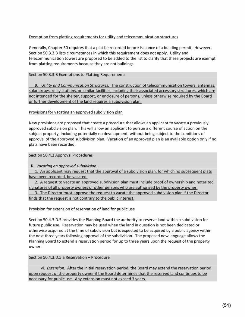
An 80-foot separation from the building envelope of the proposed flag lot to the setback of the neighboring property will be restrictive in the higher-density zones. In the R-60 and R-40 zones, which have the smallest setbacks, the front setback is 25 feet, and the rear setback is 20 feet, totaling 45 feet. During the PHED Committee worksession, Planning Staff noted that the Department had been mapping all of the R-60 and R-40 lots, and that this amendment would make clear that flag lots are best placed on larger lots. Planning Staff also noted that this flag lot amendment would give the Board more flexibility in its review of proposed flag lots. While the PHED Committee recommended approval of this amendment, it was emphasized that flag lots should not be banned, and there should be wiggle room to prevent unused land. Platting Exemption for Utility and Communication Structures Generally, plats must be recorded before issuance of a building permit. Section 50.3.3.B lists exemptions to this requirement. Utility and communication structures, such as telecommunications towers, do still require a “building” permit, despite not being “buildings”. However, utility rights-of-way are not platted, so requiring a recorded lot for a utility or telecommunications structure that is not habitable, and often in the right-of-way, is inconsistent and creates unnecessary hurdles. Therefore, this SRA includes a platting exemption for utility and communication structures.
9. Utility and Communication Structures. The construction of telecommunications towers, antennas, solar arrays, relay stations, or similar facilities, including their associated accessory structures, which are not intended for the shelter, support, or enclosure of persons, unless otherwise required by the Board or further development of the land, requires a subdivision plan.
5
Vacating Approved Subdivisions Currently, there is an informal process where an applicant could request to vacate a previously-approved subdivision plan, or the applicant could just let the validity period expire. This amendment creates a formal process for vacating. By vacating the plan, an applicant will be able to choose a different course of action on the subject property, including no development on the land. Vacating will mean the applicant is not subject to the conditions of approval of the approved subdivision plan, such as a forest conservation plan, if they do not plan on going forward with the preliminary plan or would like to sell and have someone else come in on a new application. Of note, vacating will only be an available option if no plats have been recorded.
K. Vacating an approved subdivision. 1. An applicant may request that the approval of a subdivision plan, for which no
subsequent plats have been recorded, be vacated. 2. A request to vacate an approved subdivision plan must include proof of ownership
and notarized signatures of all property owners or other persons who are authorized by the property owner.
3. The Director must approve the request to vacate the approved subdivision plan if the Director finds that the request is not contrary to the public interest.
Extension of Reservation of Land for Public Use Under Section 50.4.3.D.5, when the Board determines that a tract being subdivided includes land that is necessary for public use but will not immediately be acquired by donation, dedication, purchase, or condemnation when the plat is recorded, the Board may require reservation of that land. Said land can be reserved for rights-of-way, public schools, parks, recreational areas, and other public uses. Large land subdivisions that include land reservation may take many years to proceed. Therefore, SRA 20-02 allows the Planning Board to, at the request of the property owner, extend the reservation period for up to three years.
vi. Extension. After the initial reservation period, the Board may extend the reservation period upon request of the property owner if the Board determines that the reserved land continues to be necessary for public use. Any extension must not exceed 3 years.
Initiation Date for APF Validity Period Approved subdivision plans have a plan validity period as well as an adequate public facilities (APF) review validity period. Plan validity is the period of time during which a plat must be recorded; APF validity is the period of time in which building permits must be issued. The current time limits are 3 years for the plan validity and 5 years for the APF validity. Under Section 50.4.2.G, the plan validity period starts on the initiation date which, if no appeal has been filed, is 30 days from the mailing date of the resolution. If an appeal has been filed, the validity period is tolled until the Court’s final decision. Under Section 50.4.3.J, no initiation date for the APF validity period is specified. According to Planning Staff’s memorandum, the APF validity period starts 30 days before the plan validity period starts and does not have a tolling period for appeals. SRA 20-02 ensures that the APF validity period does not expire due to an appeal by specifying an initiation date for the APF validity period. It also clarifies that if a corrected resolution is issued, the initiation date is the date on the original resolution. Using the date on the original resolution makes sense, since corrections are typically minor.
6
5. Validity period.
a. Initiation date. The adequate public [[facility]] facilities validity period starts on the later of: i. 30 days from the date of mailing indicated on the written resolution; or ii. if an administrative appeal is timely noted by any party authorized to file an
appeal, the date upon which the court having final jurisdiction acts, including the running of any further applicable appeal periods.
b. If a corrected resolution is issued, the initiation date remains the date of mailing indicated on the original resolution.
Limitation on Planning Board APF Extensions Under current regulations, a subdivision can be granted multiple extensions, in succession, with no limit on the total length of the extension period. According to Planning Staff, if the maximum length of all currently allowable extensions is applied, then the APF validity period could be as long as 36 years. In addition, the County Council can extend the validity period. The issue is that these plans tie up development capacity that other projects might better use. The proposed amendment would limit the total length of new APF validity extensions to 12 years. This does not include special validity period extensions, such as those granted by the County Council.
h. No combination of extensions of APF validity approved under Section 4.3.J.7 may exceed a total of 12 years from the date of the original APF expiration.
During the PHED Committee worksession, questions were raised as to why the extension period should still be as long as 12 years. The Planning Board Chair noted that large projects happen in phases, and therefore sometimes need the additional 12 years. He noted that most projects are completed much quicker, and that the Planning Department and Planning Board have triggers along the way so that to get the additional 12-year extension, a developer would have to show that they have been making progress. Planning Staff also noted that many projects would not qualify for the full 12-year extension. Subdivision of Land within an Approved Cluster Subdivision SRA 20-02 makes it clear that subdivisions approved under the cluster method of development cannot later be subdivided further. Per Section 4.3.2.B of the Zoning Ordinance, “the cluster method of development provides an optional method of development that encourages the provision of community open space for active or passive recreation as well as the preservation and enhancement of natural resources.” This method allows flexibility in lot layout and for a variety of building types, as well as providing open space for common use. To accomplish this, certain changes in lot area and dimensions are allowed. Due to the changes made under this method of development, which already allows changes in lot areas and dimensions to create open space, preventing further subdivision of land approved under this method is crucial. SRA 20-02 makes it clear that future subdivision of the land will not be permitted. On June 7, 2021, a letter was received from the Housing Opportunities Commission of Montgomery County (HOC), owner and developer of the Sandy Spring Meadow subdivision in Sandy Spring.3 This property was originally developed in the 1980s under the R-60 zoning provisions in place at the time. The owners intend to amend the prior cluster development approvals by obtaining approvals under the MPDU
3 That letter is included in this packet.
7
Optional Method of Development of the R-60 Zone for a small portion of the existing subdivision. The new plan would remove 11 single-family detached lots and an open space parcel and create a mix of affordable units. Therefore, Planning Staff supported, and the PHED Committee unanimously recommended approval of, the following amendment:
e. future subdivision of land within the approved cluster subdivision that would result in the creation of additional lots is not permitted after the property is platted[[.]], except for amendments to cluster subdivisions that were approved prior to October 30, 2014 and that result in land being reviewed and approved as part of an Optional Method MPDU Development application with at least 25% moderately priced dwelling units (MPDUs), provided that the remaining portion of the cluster subdivision complies with all applicable development standards.
Landscape and Lighting Plans Landscape and lighting plans will now be required for places of worship and institutional uses.
N. [[Landscape and Lighting Plans]] Landscape and lighting plans. 1. For places of worship and institutional uses, a landscaping and lighting plan, which
must also include the parking lot layout, must be submitted for review and approval concurrently with the preliminary plan.
Approval Procedure for Pre-Preliminary Submissions For pre-preliminary submissions, an applicant may now choose whether action will be advisory (if reviewed only by the Development Review Committee) or binding (if reviewed by the Board). As this is the pre-preliminary submission, this option can streamline the process and should not have any unintended consequences.
C. Action on a pre-preliminary submission. At the applicant’s discretion, action on a pre-preliminary plan may be either advisory if only reviewed by the Development Review Committee or binding if reviewed by the Board.
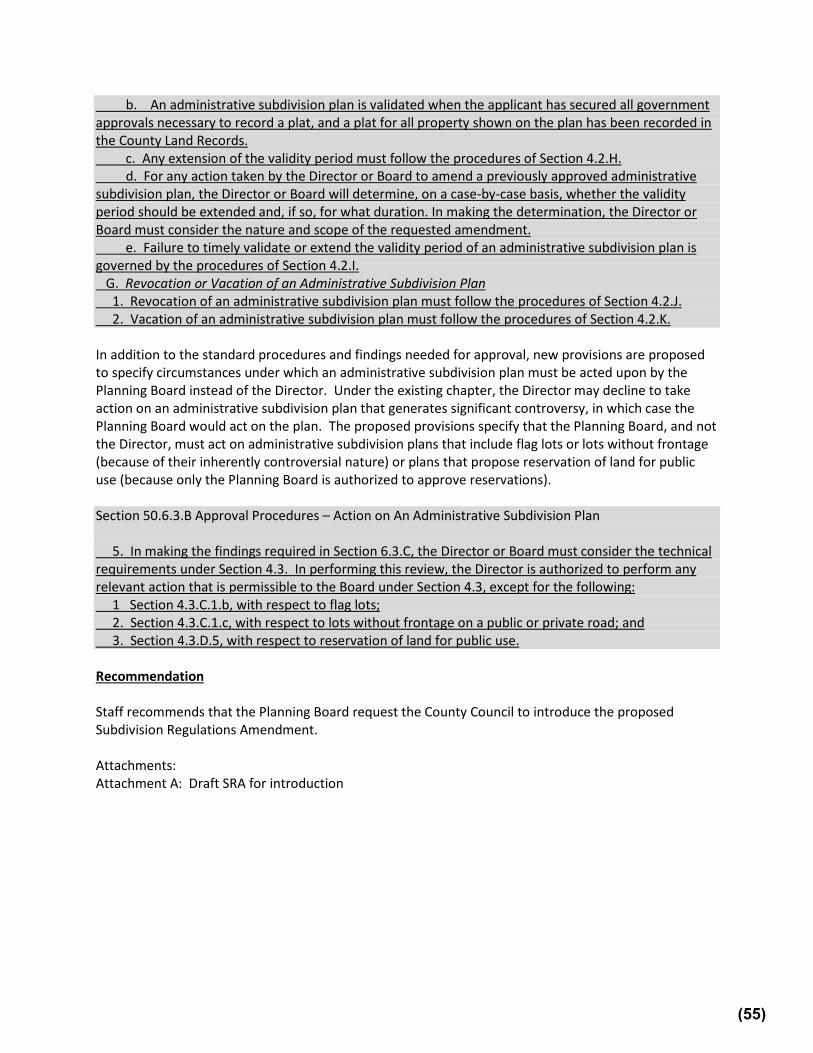
Administrative Subdivision: Approval Procedures, Required Findings, Plan Certification, Amendments, Validity Period, Revocation, and Vacation of Approval First, the term “administrative subdivision plan” has been replaced in various places and replaced with “preliminary plan.” This is because an administrative subdivision plan is included as a type of preliminary plan. This does not, however, change the need for separate requirements. Administrative subdivision plans are similar to preliminary plans but they can usually be acted on by the Planning Director instead of the Planning Board. They have a 90-day review period instead of 120 days, simplified procedures, and generally require less time to make a decision. The current provisions for administrative subdivision plans do not include specific requirements for necessary findings for approval, plan certification, plan validity, revocation of an approved plan, and vacation of an approved plan. Because of this, they have been approved under the provisions and findings for preliminary plans. The creation of separate approval procedures and findings will provide greater
8
clarity for applicants, staff, and the Planning Board. The proposed procedures and findings are still similar but have small modifications to reflect the context of administrative subdivision plans. The amendment adds findings, explains how to establish plan validity and plan certification, and makes it more clear how these approval actions should work. New provisions are also proposed to specify when an administrative subdivision plan should be acted on by the Planning Board instead of the Planning Director. Specifically, the Director must not act on flag lots or lots without frontage due to their controversial nature. And the Director cannot act on reservation of land for public use, because only the Planning Board has the authority to authorize those.
5. In making the findings required in Subsection 6.3.C, the Director or Board must consider the technical requirements under Section 4.3. In performing this review, the Director is authorized to perform any relevant action that is permissible to the Board under Section 4.3, except for the following: a. Section 4.3.C.1.b, with respect to flag lots; b. Section 4.3.C.1.c, with respect to lots without frontage on a public or private road;
and c. Section 4.3.D.5, with respect to reservation of land for public use.
Crossing Lot Lines As noted above, during the public hearing the County Council heard testimony from William Kominers, an attorney with Lerch, Early & Brewer. Planning Staff and Council Staff recommended approval of an amendment suggested on the last page of Mr. Kominers’ letter, which was also referenced during his testimony during the public hearing.4 He wrote that an older version of the Subdivision Regulations made clear that building permits must not be approved for buildings or structures that cross a lot line. In SRA 20-02, Section 50.3.2.B states: “A building permit may only be issued for a building located on a lot or parcel shown on a plat recorded in the County Land Records or on a parcel exempt from recording requirements under Subsection 3.3.B.” He argued that use of the word “a” before lot or parcel is not enough to make this restriction clear. Planning Staff agreed that clearer language is appropriate. The PHED Committee unanimously recommended approval of the suggested amendment:
[Construction of a new principal] A building permit may only [occur] be issued for a building located on a lot or parcel shown on a plat recorded in the County Land Records or on a [property that is] parcel exempt from recording requirements under [Section 3.3.B.] Subsection 3.3.B, and in a manner that does not result in the building or structure crossing a lot line.
Additional amendments recommended by the PHED Committee
1. As discussed above, SRA 20-02 adds several provisions regarding flag lots. After introduction of the SRA, concerns were raised regarding the clarity of the setback language. Therefore, the following revisions were made:
i. in residential zones, the Board must require building restriction lines as
needed to provide separation of at least 80 feet between the building envelope of the proposed flag lot and:
4 That letter is included in this packet.
9
(a) the building envelopes of all lots that are adjacent to the rear lot line of the proposed flag lot [[or]]; and
(b) [[that are between the proposed flag lot]] the building envelopes of all lots that are between the proposed flag lot and the road on which it fronts;
iii. in residential zones, the Board must require building restriction lines as
needed to provide separation of at least 80 feet between the building envelope of the proposed lot without frontage and: (a) the building envelopes of all lots that are adjacent to the rear lot line
of the proposed lot without frontage [[or]]; and (b) [[that are between the proposed lot without frontage and]] the
building envelopes of all lots that are between the proposed lot without frontage and the road from which it is accessed;
2. As noted in footnote 1 above, SRA 20-02 adds a requirement that a new determination of
school adequacy must be conducted for any unbuilt dwelling units during review of an APF validity extension request, consistent with the Growth and Infrastructure Policy. This provision already exists in Chapter 50. Currently, 50.4.3.J( e) states: “(e) if the remaining unbuilt units would generate more than 10 students at any school serving the development, the Board must make a new adequate public facilities determination for school adequacy for the remaining unbuilt units under the school test in effect at the time of Board review.” Therefore, this additional provision in SRA 20-02 is not needed.
[[(e) a new adequate public facilities determination for school adequacy is
required for the remaining unbuilt units under the school test in effect at the time of Board review.]]
3. Because a stop work order can also be issued by DPS, the definition of a “stop work order”
was revised so that the listed definition applies only to this Chapter.
Stop Work Order: In this Chapter, [[An]] an administrative order issued by an enforcement agent that requires a person to discontinue any further development, construction, or other land disturbance activity authorized by a Planning Board Action or a Director Action until a violation has been corrected.
4. Due to legal concerns, the PHED Committee does not recommend the Planning Board’s
requested amendment to change the wording on the Board’s approval procedures from “hold hearing” to “hear testimony”.
Draft No. & Date: 4 ‒ 7/26/2021 Introduced: December 8, 2020 Public Hearing: February 9, 2021 Adopted: Effective: Ordinance No.:
COUNTY COUNCIL FOR MONTGOMERY COUNTY, MARYLAND SITTING AS THE DISTRICT COUNCIL FOR THAT PORTION OF
THE MARYLAND-WASHINGTON REGIONAL DISTRICT WITHIN MONTGOMERY COUNTY, MARYLAND
Lead Sponsor: Council President at the request of the Planning Board ______________________________________________________________________________ AN AMENDMENT to the Montgomery County Subdivision Regulations to:
- delete the definition of Adequate Public Facilities Ordinance (APFO)[[, Licensed Land Surveyor,]]and Subdivision Staging Policy[[, and Septic Tiers]];
- amend the definition of Administrative Civil Penalty, Board, Building Restriction Line, Citation, Civil Fine, Enforcement Agent, Engineer, Preliminary Plan, Pre-Preliminary Plan, Centerline of Road;
- add a definition for Building Envelope, [[County]] Growth and Infrastructure Policy, Director Action, Growth Tiers, Land Surveyor, and Utilities;
- amend provisions concerning: filing and approval procedures for preliminary plan submission the lot design of flag lots, frontage on a public or private road, alleys or pedestrian
paths for residential lots, the exemption to certain requirements for Utility and Communication Structures; the taxing provisions for all public reservations; the extensions for all public reservations; the access easements for alleys; establishing utility easements in a subdivision; adequate public facilities; a residential cluster subdivision; the approval of an administrative subdivision, a minor subdivision or a plat; granting a waiver from any requirement of Chapter 50;
- add a provision for places of worship and institutional uses, that a landscaping and lighting plan be submitted for review and approval concurrently with the preliminary plan; and
- generally amend the provisions governing Chapter 50.
(1)
By amending
Montgomery County Code Chapter 50. “Subdivision of Land” Division 50.2. ‘INTERPRETATION AND DEFINED TERMS” Section 50.2.2. “Definitions” Division 50.3. “GENERAL REQUIREMENTS” Section 50.3.2. “Record Plat Required” Section 50.3.3. “Exemptions to the Requirements of this Chapter” Section 50.3.6. “Submission Procedures for Subdivision Plans” Division 50.4. ‘PRELIMINARY PLAN” Section 50.4.1. “Filing and Specifications” Section 4.2. “Approval Procedure” Section 4.3. “Technical Review” Division 50.5. “PRE-PRELIMINARY SUBMISSIONS” Section 50.5.2. “Approval Procedure” Division 50.6. “ADMINISTRATIVE SUBDIVISION PLAN” Section 50.6.1. “Applicability” Section 50.6.2. “Filing Requirements” Section 50.6.3. “Approval Procedures” Division 50.7. “MINOR SUBDIVISION” Section 50.7.1. “Applicability” Section 50.7.2. “Procedure for Platting Minor Subdivisions” Division 50.8. “PLATS – GENERALLY” Section 50.8.1. “Filing and Specifications” Section 50.8.2. “Approval Procedure” Section 50.8.3. “Recording Procedure” Division 50.9. “WAIVERS FROM THIS CHAPTER” Section 50.9.5. “Procedure for Granting Waivers” Division 50.10. “ADMINISTRATIVE PROCEDURES” Section 50.10.2. “Bonding and Surety” Section 50.10.6. “Enforcement of Chapter”
Boldface Heading or defined term. Underlining Added to existing law by introduced Subdivision Regulation
Amendment. [Single boldface brackets] Deleted from existing law by introduced Subdivision
Regulation Amendment. Double underlining Added to the Subdivision Regulation Amendment by
amendment. [[Double boldface brackets]] Deleted from existing law or the Subdivision Regulation
Amendment by amendment. * * * Existing law unaffected by Subdivision Regulation Amendment.
(2)
OPINION Subdivision Regulation Amendment (SRA) 20-02, lead sponsor Council President at the request of the Planning Board, was introduced on December 8, 2020. Chapter 50, Subdivision Regulations, was adopted by the County Council in 2017. SRA 20-02 clarifies language, corrects mistakes, and adds necessary missing provisions. While many of the amendments are minor, there are some major changes, including:
⁻ new provisions for the approval of flag lots and lots without frontage; ⁻ new exemption from platting requirements for utility and telecommunications structures; ⁻ new provisions for vacating an approved subdivision plan; ⁻ new provision for extension of reservation of land for public use; ⁻ new provision to specify an initiation date for the adequate public facilities validity
period, similar to the existing initiation date provisions for plan validity; ⁻ new limitation on Planning Board-approved APF extensions to a total of 12 years; ⁻ new provisions for administrative subdivision plans for approval procedures, required
findings, plan certification, amendments, validity period, revocation, and vacation of approval; and
⁻ a grandfathering provision to allow applications to be reviewed under the regulations that were in effect at the time of the application’s filing.
The Council’s public hearing was conducted on February 9, 2021. There were two speakers. Neil Braunstein, Supervisor, IRC, from the Planning Department testified in support. William Kominers, an attorney from Lerch, Early & Brewer also testified. He testified that he had a number of suggested revisions, but was generally in support of the SRA. The Council referred the text amendment to the Planning, Housing, and Economic Development (PHED) Committee for review and recommendation. The PHED Committee held a worksession on July 12, 2021. The Committee unanimously recommended approval of SRA 20-02 with amendments. Those amendments included minor formatting amendments proposed by both Council Staff and Planning, as well as an amendment regarding structures crossing lot lines from the Planning Department. The Council agreed with the recommendation of the Committee. For these reasons, and because to approve this amendment will assist in the coordinated, comprehensive, adjusted, and systematic development of the Maryland-Washington Regional District located in Montgomery County, Subdivision Regulation Amendment No. 20-02 will be approved as amended.
ORDINANCE
The County Council for Montgomery County, Maryland, sitting as the District Council
for that portion of the Maryland-Washington Regional District in Montgomery County, Maryland, approves the following Ordinance:
(3)
Sec. 1. Division 50.2 is amended as follows: 1
DIVISION 50.2. INTERPRETATION AND DEFINED TERMS 2
* * * 3
Section 2.2. Definitions 4
All terms used in this Chapter that are defined in Chapter 59 or Chapter 49 have 5
the same meanings as the definitions in those Chapters, unless otherwise defined 6
here. In this Chapter, the following words and phrases have the meanings 7
indicated. 8
A. 9
[Adequate Public Facilities Ordinance (APFO): Section 4.3.J of this Chapter, 10
which specifies that the Board must find that public facilities will be adequate to 11
support and serve a proposed subdivision before approval.] 12
Administrative Civil Penalty: A monetary penalty imposed by the Board after 13
considering the factors in this Chapter for violating a Planning Board [action] 14
Action or Director Action. 15
Administrative Subdivision Plan: A preliminary plan [for a proposed subdivision 16
prepared and] submitted for the Director’s approval before the preparation of a 17
plat. 18
* * * 19
Board: The Montgomery County Planning Board of the Maryland-National Capital 20
Park and Planning Commission. 21
* * * 22
(4)
Building Envelope: The portion of a lot, enclosed by the front, rear, and side 23
setback lines and any additional building restriction lines, in which a structure may 24
be placed. 25
Building Restriction Line: A line designating an area in which development or 26
building is prohibited under this Chapter [by the Board under Section 50.4.3.K of 27
these regulations]. 28
* * * 29
Citation: A document noting a violation of a Planning Board [action] Action or 30
Director Action, seeking to impose a civil fine or corrective action. 31
Civil Fine: A requirement to pay a predetermined sum of money specified in an 32
administrative citation for violating a Planning Board [action] Action or Director 33
Action. 34
* * * 35
[[County Growth and Infrastructure Policy: The resolution or law approved by the 36
District Council to determine the adequacy of public facilities and services.]] 37
* * * 38
Director Action: A written decision on a preliminary plan, site plan, or other plan, 39
including all associated terms, conditions, requirements, and other obligations or 40
limits, made by the Director under State law and Chapters 50 and 59, including any 41
regulations approved under State or County law. For the purposes of an 42
enforcement action, a Director Action excludes a decision made by the Director 43
under Chapter 22A. 44
* * * 45
(5)
Enforcement Agent: The Director, or the Director’s designee responsible for 46
determining compliance with a Planning Board Action or Director Action. 47
Engineer: A professional engineer [registered] licensed in Maryland. 48
* * * 49
Growth Tiers: Tiers adopted by Montgomery County under Subtitle 5 of the Land 50
Use Article. 51
* * * 52
[Licensed] Land Surveyor: A land surveyor who is licensed in the State to 53
“practice land surveying” as defined in the Maryland Business Occupations and 54
Professions Code Ann. Section 15-101 [(1995 Repl. Vol.)], as amended. 55
* * * 56
Preliminary Plan: A drawing for a proposed subdivision [prepared and] submitted 57
for [Board] approval before the preparation of a plat. 58
Pre-Preliminary Plan: A drawing for a proposed subdivision [prepared and] 59
submitted for binding or non-binding advice before the submission of a 60
[Preliminary Plan] preliminary plan. 61
* * * 62
Road, Centerline of: A line established as a centerline of a road right-of-way by 63
any State, County, or other official agency or governing body with jurisdiction and 64
shown on an officially adopted plan or recorded plat. In the absence of an official 65
centerline, the Board or Director must establish the centerline with consultation 66
from the applicable agency with jurisdiction over the road. 67
(6)
* * * 68
Stop Work Order: In this Chapter, [[An]] an administrative order issued by an 69
enforcement agent that requires a person to discontinue any further development, 70
construction, or other land disturbance activity authorized by a Planning Board 71
Action or a Director Action until a violation has been corrected. 72
2. Completion. The Board [may] must not approve a final plat until the 531
developer demonstrates that the applicable utility companies or public 532
agencies are able to provide utility [service] services to the 533
subdivision and installation by the developer has been assured under 534
Section 10.2. 535
3. Easements. 536
[a.] The subdivider must establish utility easements[, which must be 537
shown on the record plat,] to allow for installation of all utility 538
(24)
[lines] facilities servicing the proposed subdivision and the 539
future extension thereof to any property adjoining the 540
subdivision[, which] that: 541
[i]a. provide the minimum area needed to maintain each of the 542
[lines] facilities as determined by the Board [with] in 543
consultation [from] with the utility [provider; and] 544
providers; 545
[ii]b. are adjacent to, or accessible from, a road right-of-way[.]; 546
c. are available to all utilities; and 547
d. are shown on the record plat. 548
[With County DPS permission] With Department of Permitting Services 549
approval, utilities may be placed within conduit in public road rights-of-way. 550
Utilities placed within private road rights-of-way by a developer must [also] 551
be in conduit. 552
[b. When a private road is allowed, the Board must also require the 553
developer to provide to the County an additional public 554
infrastructure area at least 4 feet wide, adjacent to private roads 555
or in other appropriate locations that create contiguous service 556
corridors within the development that connect to and are 557
accessible from a public right-of-way to provide forfuture: 558
i. relocation of existing utilities permitted to remain in a 559
road right-of-way; and 560
ii. installation of new communication facilities. 561
When a structure is proposed under a private road and the 562
public infrastructure area is located in the road right-of-way, the 563
developer must construct conduits within the infrastructure area 564
to the County’s specification.] 565
(25)
J. Adequate Public Facilities [Ordinance] ([APFO]APF). 566
* * * 567
5. Validity period. 568
a. Initiation date. The adequate public [[facility]] facilities validity 569
period starts on the later of: 570
i. 30 days from the date of mailing indicated on the written 571
resolution; or 572
ii. if an administrative appeal is timely noted by any party 573
authorized to file an appeal, the date upon which the 574
court having final jurisdiction acts, including the running 575
of any further applicable appeal periods. 576
b. If a corrected resolution is issued, the initiation date remains the 577
date of mailing indicated on the original resolution. 578
[a]c. A determination of adequate public facilities made under this 579
Chapter is timely and remains valid: 580
i. for 12 years after the [preliminary plan is approved] 581
initiation date for any plan approved after July 24, 582
1989[,] but before October 19, 1999; 583
ii. for no less than 5 and no more than 12 years after the 584
[preliminary plan is approved] initiation date, as 585
determined by the Board when it approved the plan, for 586
any plan approved after October 18, 1999[,] but before 587
August 1, 2007; 588
iii. for no less than 7 and no more than 12 years after the 589
[preliminary plan is approved] initiation date, as 590
determined by the Board when it approved the plan, for 591
(26)
any plan approved after March 31, 2009[,] but before 592
April 1, 2017; [[and]] 593
iv. for no less than 5 and no more than 10 years after the 594
[preliminary plan is approved] initiation date, as 595
determined by the Board when it approved the plan, for 596
any plan approved after July 31, 2007[,] and before April 597
1, 2009, or after March 31, 2017[[.]];and 598
v. for no less than 5 and no more than 10 years after the 599
application is approved, as determined by the Board 600
when it approved the application, for any adequate public 601
facilities determination made in association with a site 602
plan under Chapter 59 or building permit under Chapter 8 603
approved after July 31, 2007 and before April 1, 2009, or 604
after March 31, 2017. 605
[b]d. If an applicant requests a longer validity period than the 606
minimum specified in Subsection 4.3.J.5.a, the applicant must 607
submit a development schedule or phasing plan for completion 608
of the project to the Board for its approval. 609
* * * 610
6. Validity period – County arts or entertainment use. 611
* * * 612
b. The Board must grant an application to extend the validity 613
period established under this paragraph for an additional 5 years 614
if: 615
* * * 616
ii. at any time during the [24 months] 2 years before the 617
application for extension being filed, the vacancy rate for 618
(27)
class A office buildings in the Central Business District 619
in which the project is located reaches 10 percent for 620
direct and sublet space combined, as measured by a 621
commercial Multiple Listings Service benchmark; or 622
* * * 623
7. Extensions. 624
a. Application. Only the Board may extend the validity period for 625
a determination of adequate public facilities; however, a request 626
to amend any validity period phasing schedule may be 627
approved by the Director if the length of the total validity 628
period is not extended. 629
* * * 630
iii. For each extension of an adequate public facilities 631
determination: 632
* * * 633
[[(e) a new adequate public facilities determination for 634
school adequacy is required for the remaining 635
unbuilt units under the school test in effect at the 636
time of Board review.]] 637
b. The Board may approve an amendment to the new development 638
schedule approved under [paragraph] Section 4.3.J.7.a.ii if the 639
applicant shows that financing has been secured for either: 640
* * * 641
e. Applications with significant infrastructure investment. The 642
Board may extend [a] an initial determination of adequate 643
public facilities once for up to 12 more years beyond the 644
otherwise applicable validity period if the Board finds that: 645
(28)
i. the preliminary plan or APF approval for the 646
development required a significant commitment of funds 647
by the applicant, amounting to at least $3 million, as 648
adjusted annually from February 2017 by the consumer 649
price index, to comply with specified infrastructure 650
conditions; 651
* * * 652
h. No combination of extensions of APF validity approved under 653
Section 4.3.J.7 may exceed a total of 12 years from the date of 654
the original APF expiration. 655
K. Environment. 656
* * * 657
2. Restriction of subdivision for environmental protection. 658
* * * 659
b. Restrictions. 660
i. General. In addition to any requirement imposed under 661
Chapter 22A, the proposed preliminary plan [or 662
administrative subdivision plan] may be restricted under 663
this Section by: 664
* * * 665
L. Residential cluster subdivision. 666
* * * 667
2. Conditions for use. The use of the cluster method of development is 668
subject to Board approval and the following conditions and 669
requirements: 670
* * * 671
(29)
c. the open space and green areas proposed by the applicant in the 672
cluster development must comply with the general purpose of 673
cluster development, and the application must include a plan 674
detailing the post-development maintenance responsibilities and 675
use of those areas; [and] 676
d. the Board must count the land dedicated to public use for 677
school and park sites in the tract area for the purpose of 678
calculating density, and allow the use of the resulting density 679
development of the remaining land when this can be 680
accomplished in compliance with the purposes of this 681
Section[.]; and 682
e. future subdivision of land within the approved cluster 683
subdivision that would result in the creation of additional lots is 684
not permitted after the property is platted[[.]], except for 685
amendments to cluster subdivisions that were approved prior to 686
October 30, 2014 and that result in land being reviewed and 687
approved as part of an Optional Method MPDU Development 688
application with at least 25% moderately priced dwelling units 689
(MPDUs), provided that the remaining portion of the cluster 690
subdivision complies with all applicable development 691
standards. 692
* * * 693
N. [[Landscape and Lighting Plans]] Landscape and lighting plans. 694
1. For places of worship and institutional uses, a landscaping and 695
lighting plan, which must also include the parking lot layout, must be 696
submitted for review and approval concurrently with the preliminary 697
plan. 698
(30)
* * * 699
Sec. 4. Division 50.5 is amended as follows: 700
DIVISION 50.5. PRE-PRELIMINARY SUBMISSIONS 701
* * * 702
Section 5.2. Approval Procedure 703
* * * 704
C. Action on a pre-preliminary submission. 705
At the applicant’s discretion, action on a pre-preliminary plan may be either 706
advisory if only reviewed by the Development Review Committee or 707
binding if reviewed by the Board. 708
* * * 709
Sec. 5. Division 50.6 is amended as follows: 710
DIVISION 50.6. ADMINISTRATIVE SUBDIVISION PLAN 711
* * * 712
Section 6.1. Applicability 713
The subdivider may file an administrative subdivision plan application [instead of 714
a preliminary plan] under the following circumstances. [The Director must review 715
the necessary technical requirements of the administrative subdivision plan under 716
Section 4.3.] Administrative subdivision plans may only be used to create lots, as 717
expressly described below. 718
A. Existing places of worship and institutional uses. [The Board may approve 719
a] A lot may be created for existing facilities such as[:] places of worship, 720
private schools, country clubs, private institutions, and similar uses located 721
on unplatted parcels[[,]] if: 722
* * * 723
(31)
3. [requirements for meeting] forest conservation[,] plan approval and 724
stormwater management[,] and environmental protection 725
requirements, if applicable, are satisfied before approval of the plat; 726
* * * 727
6. [the property is the subject of an approved conditional use and] all 728
conditions of [the] any conditional use approval, to which the property 729
may be subject, remain in full force. 730
B. Subdivision for creation of certain residential lots located in the 731
Agricultural Reserve zone. Up to 5 lots for detached houses [are permitted] 732
may be created under these procedures in the AR zone if: 733
* * * 734
6. forest conservation plan approval and stormwater management and 735
environmental protection requirements, if applicable, are satisfied 736
before approval of the plat. 737
C. Subdivision for creation of certain residential lots. Up to 3 lots for detached 738
houses [are permitted] may be created in any residential or rural residential 739
zone under these procedures if: 740
* * * 741
5. forest conservation[,] plan approval, stormwater management, and 742
environmental protection requirements, if applicable, are satisfied 743
before approval of the plat. 744
D. Consolidation of an existing [lots] lot with another lot or [parts] part of 745
[lots] a lot in a nonresidential zone. In a nonresidential zone, a lot may be 746
created by combining existing adjoining lots, or a lot and a part of a 747
previously platted lot, if: 748
* * * 749
(32)
4. forest conservation plan, stormwater management, and environmental 750
protection requirements, if applicable, are satisfied before approval of 751
the plat; and 752
5. when located in a special protection area, [and] all applicable special 753
protection area requirements and guidelines are satisfied before the 754
Board approves the plat. 755
For the purposes of this section, a part of a lot that qualifies for the 756
exemption stated in Subsection 3.3.B.2 may be used in lieu of a whole lot. 757
E. Subdivision application for property to be used as Signature Business 758
Headquarters under Section 3.5.8.D of the Zoning Ordinance. A lot or lots 759
created for a Signature Business Headquarters may be approved[[,]] if: 760
* * * 761
3. forest conservation[,] plan approval, stormwater management, and 762
environmental protection requirements, if applicable, are satisfied 763
before approval of the plat; and 764
4. when located in a special protection area, all special protection area 765
requirements are satisfied before approval of the plat [, if the subject 766
property is located in a special protection area]. 767
Section 6.2. Filing Requirements 768
A. Filing. The Applicant must file the administrative subdivision plan and 769
applicable supporting information under Subsection 4.1.C, together with an 770
application form and fee to satisfy Subsection 4.1.A. 771
* * * 772
Section 6.3. Approval Procedures 773
* * * 774
B. Action on an administrative subdivision plan. 775
(33)
1. Director Action. An administrative subdivision plan may be approved 776
by the Director without a public hearing if no objection to the 777
application is received within 30 days after the application notice is 778
sent. After receiving the recommendations of the Development 779
Review Committee and other reviewing agencies, and considering 780
correspondence from other interested parties, the Director must 781
approve or disapprove the administrative subdivision plan in writing. 782
[In the alternative, the Director may require that the plan be acted on 783
by the Board. When applicable, the Director must schedule Board 784
action on its next available agenda. If approved, the plan will remain 785
valid under Section 4.2.G, by which time a plat must be recorded.] 786
2. Planning Board Action. If an objection is received within 30 days 787
after the application notice is sent, and the Director considers the 788
objection relevant, a public hearing and action by the Board is 789
required. The Director may also require that the plan be acted on by 790
the Board when no objection is received. When applicable, the 791
Director must schedule a Board hearing on its next available agenda. 792
3. All necessary improvements to support the development must be 793
completed or assured under Section 10.2. 794
[3]4. The Director must take action on an administrative subdivision plan or 795
schedule a public hearing within 90 days after the date an application 796
is accepted. The Director may postpone the public hearing once, by up 797
to 30 days, without Board approval. The Director or applicant may 798
request an extension beyond the original 30 days with Board approval. 799
Any extension of the public hearing must be noticed on the hearing 800
agenda with the new public hearing date indicated. 801
(34)
5. In making the findings required in Subsection 6.3.C, the Director or 802
Board must consider the technical requirements under Section 4.3. In 803
performing this review, the Director is authorized to perform any 804
relevant action that is permissible to the Board under Section 4.3, 805
except for the following: 806
a. Section 4.3.C.1.b, with respect to flag lots; 807
b. Section 4.3.C.1.c, with respect to lots without frontage on a 808
public or private road; and 809
c. Section 4.3.D.5, with respect to reservation of land for public 810
use. 811
C. Required Findings. To approve an administrative subdivision plan, the 812
Director or Board must make the following findings: 813
1. the layout of the subdivision, including size, width, shape, orientation 814
and density of lots, and location and design of roads is appropriate for 815
the subdivision given its location and the type of development or use 816
contemplated and the applicable requirements of Chapter 59; 817
2. the administrative subdivision plan substantially conforms to the 818
master plan; 819
3. public facilities will be adequate to support and service the area of the 820
subdivision; 821
4. all Forest Conservation Law, Chapter 22A requirements are satisfied; 822
5. all stormwater management, water quality plan, and floodplain 823
requirements of Chapter 19 are satisfied; 824
6. any burial site of which the applicant has actual notice or constructive 825
notice or that is included in the Montgomery County Cemetery 826
Inventory and located within the subdivision boundary is approved 827
under Subsection 4.3.M; and 828
(35)
7. any other applicable provision specific to the property and necessary 829
for approval of the subdivision is satisfied. 830
D. Plan [[Certification]] certification. 831
Every administrative subdivision plan approved by the Board or the Director 832
must be certified by the Director to confirm that the plan reflects the 833
approval. Any modification of the plan conditioned by the approval must be 834
included in the plan before receiving the approval stamp. The approved plan 835
must be filed in the records of the Board. 836
E. Amendments. 837
Any amendment to an approved administrative subdivision plan must follow 838
the procedures, meet the criteria, and satisfy the requirements of this 839
Division. 840
F. Plan [[Validity]] validity. 841
1. Initiation date. The plan validity period for administrative subdivision 842
plans starts on the later of: 843
a. 30 days from the date of mailing indicated on the Director’s 844
written approval or the Board’s resolution; or 845
b. the date upon which the court having final jurisdiction acts, 846
including the running of any further applicable appeal periods, 847
if an administrative appeal is timely noted by any party 848
authorized to file an appeal. 849
If a corrected resolution is issued, the initiation date remains the date 850
of mailing indicated on the original resolution. 851
2. Duration. 852
a. An approved administrative subdivision plan remains valid for 853
3 years after its initiation date. 854
(36)
b. An administrative subdivision plan is validated when the 855
applicant has secured all government approvals necessary to 856
record a plat, and a plat for all property shown on the plan has 857
been recorded in the County Land Records. 858
c. Any extension of the validity period must follow the procedures 859
of Subsection 4.2.H. 860
d. For any action taken by the Director or Board to amend a 861
previously approved administrative subdivision plan, the 862
Director or Board will determine, on a case-by-case basis, 863
whether the validity period should be extended and, if so, for 864
what duration. In making the determination, the Director or 865
Board must consider the nature and scope of the requested 866
amendment. 867
e. Failure to timely validate or extend the validity period of an 868
administrative subdivision plan is governed by Subsection 4.2.I. 869
G. Revocation or [[Vacation of an Administrative Subdivision Plan]] vacation 870
of an administrative subdivision plan. 871
1. Revocation of an administrative subdivision plan must satisfy 872
Subsection 4.2.J. 873
2. Vacation of an administrative subdivision plan must satisfy 874
Subsection 4.2.K. 875
H. Appeal of an administrative subdivision plan. 876
* * * 877
Sec. 6. Division 50.7 is amended as follows: 878
DIVISION 50.7. MINOR SUBDIVISION 879
Section 7.1. Applicability 880
(37)
The submission of a preliminary plan [or administrative subdivision plan] under 881
Sections 4.1 and 4.2, and Sections 6.1 and 6.2, is not required for: 882
* * * 883
B. Conversion of an outlot into a lot. An outlot may be converted into a lot if: 884
* * * 885
3. all applicable requirements or agreements under the Adequate Public 886
Facilities [Ordinance] provisions in Subsection 4.3.J and the Growth 887
and Infrastructure Policy are satisfied before recording the plat; 888
* * * 889
C. Consolidation. Adjoining properties in the Rural Residential or Residential 890
Detached zones, not developed under cluster provisions, may be combined 891
in the following ways: 892
1. by consolidating 2 or more lots into a single lot, consolidating lots and 893
an outlot into a single lot, or consolidating a lot and an abandoned 894
road right-of-way, if: 895
* * * 896
c. [all] any required right-of-way dedication is provided. 897
2. by consolidating [an existing platted lot or] a part of a lot that contains 898
a legally constructed detached house or an existing platted lot[,] with a 899
piece of land created as a result of a deed, if: 900
* * * 901
E. Ownership Plat. An ownership plat may be recorded to delineate separate 902
ownership units within a lot approved for any use except for single-unit 903
living as follows: 904
* * * 905
3. Private roads [may] must not be delineated as a separate ownership 906
unit on an ownership plat. 907
(38)
* * * 908
F. Plat of correction. A plat of correction may be used for any of the following: 909
* * * 910
2. to revise easements to reflect a Planning Board [action] Action, or as 911
necessitated by a State or County agency or public utility; 912
* * * 913
Section 7.2. Procedure for Platting Minor Subdivisions 914
The subdivider of a property that satisfies the requirements for a minor subdivision 915
under Section 7.1 may submit an application for record plat for approval under 916
Section 8.1 and Section 8.2. 917
A. Additional considerations. 918
* * * 919
3. Any applicable requirements of Chapter 22A must be satisfied before 920
approval of the plat by the Board. 921
* * * 922
Sec. 7. Division 50.8 is amended as follows: 923
DIVISION 50.8. PLATS – GENERALLY 924
* * * 925
Section 8.1. Filing and Specifications 926
* * * 927
C. Plat drawing. The plat drawing prepared with the application must be an 18-928
inch by 24-inch sheet, including a margin of one-half inch outside ruled 929
border lines. It must be accurately drawn to a scale approved by the Board 930
and must include the following: 931
1. Title block. The title block must appear in the lower right corner of the 932
sheet and must include the following information: 933
* * * 934
(39)
e. name of firm of [licensed] land surveyor who prepared the plat 935
and date of completion; and 936
* * * 937
3. Surveyor certificate. Certificate by the [licensed] land surveyor in a 938
form required by the Board, certifying to the accuracy of the plat and 939
to areas included on the plat and dedicated to public use. The 940
certificate must also include conveyance information with recording 941
references of the lands contained in the plat. 942
4. Owner’s Certificate. Certificate by the owner and all parties of 943
interest, in a form required by the Board, adopting the plat; granting 944
slope, utility, conservation, or any other easements; and establishing 945
building restriction lines that are required to be drawn or noted on the 946
plat per the conditions of the approved [Preliminary Plan or 947
Administrative Subdivision Plan] preliminary plan and dedicating to 948
public use roads, alleys, rights-of-way, and any other areas approved 949
for dedication to public use by the Board. The owner must certify that 950
a [licensed] land surveyor will be engaged to set all property corner 951
markers under Subsection 4.3.G. 952
* * * 953
E. Other supporting information. The following supporting information is also 954
required with the plat application. 955
1. Documents and plans. The following documents and plans must be 956
submitted: 957
* * * 958
c. copies of approved[, preliminary or] final forest conservation 959
plan[, as appropriate,] or exemption letter; and 960
* * * 961
(40)
2. Preliminary plans using transferable development rights (TDRs). For 962
a subdivision designated in sewer category 3 conditioned upon 963
approval of a preliminary plan that uses TDRs, a new plat using less 964
than the requisite number of TDRs [may] must not be approved until 965
the sewer category has been reconfirmed by the Council. 966
* * * 967
4. Plat for a cluster subdivision. 968
* * * 969
b. Plats may be submitted in phases; however, density on any one 970
plat [may] must not exceed 115 percent of the allowed density 971
of the area included on the plat. 972
* * * 973
Section 8.2. Approval Procedure 974
* * * 975
C. Plat to comply with approved preliminary plan and site plan where 976
required. 977
1. With the exception of a minor subdivision, as defined in this Chapter, 978
no plat may be approved unless it complies with an approved 979
preliminary plan [or an administrative subdivision plan:]; however, 980
the Board may allow for minor modifications from [these plans] the 981
plan which, in its opinion, do not alter the intent of the previous 982
approval. 983
* * * 984
G. Planning Board may [hold hearing] [[hear testimony]] hold hearing on any 985
plat. The Board may, upon its own motion, [hold a hearing] [[hear 986
testimony]] hold a hearing before acting upon any plat, in accordance with 987
[notice required by] the Board’s Rules of Procedure. 988
(41)
* * * 989
I. Signing. A plat must be signed by applicable County agencies with review 990
authority before Planning Board [action] Action on the plat, unless the 991
Board specifically permits the signature to be added as a condition of its 992
approval. The plat must be signed by the authorized officers of the Board 993
after the Board acts to approve the plat or, in cases of conditional approval, 994
when the conditions are satisfied. 995
* * * 996
Section 8.3. Recording Procedure 997
A. Processing of plats. 998
* * * 999
2. The official seal of the [licensed] land surveyor who prepared the plat 1000
must be impressed upon the original approved plat and reproductions. 1001
* * * 1002
Sec. 8. Division 50.9 is amended as follows: 1003
DIVISION 50.9. WAIVERS FROM THIS CHAPTER 1004
* * * 1005
Section 9.5. Procedure for Granting Waivers 1006
A. Referral for recommendations. The Director must send a copy of each 1007
waiver request to the applicable Development Review Committee agencies 1008
for investigation, report, and written recommendation before acting on the 1009
request. For waivers requested as part of a preliminary plan[, administrative 1010
preliminary plan,] or [pre-application submission] pre-preliminary plan, 1011
those agencies must submit any report and recommendation on the waiver in 1012
the timeframes required for those plans. For separate waiver requests, final 1013
(42)
recommendation must be provided to the Director within 30 days after 1014
receiving the request, or the recommendation must be treated as favorable. 1015
* * * 1016
Sec. 9. Division 50.10 is amended as follows: 1017
DIVISION 50.10. ADMINISTRATIVE PROCEDURES 1018
* * * 1019
Section 10.2. Bonding and Surety 1020
A. Guarantee of completion of improvements before recording final plat. 1021
1. Before plat recordation, the subdivider must demonstrate to the Board 1022
or [applicable public agency must certify] the Director that the 1023
subdivider has obtained the necessary permits and bonds or provided 1024
other surety that ensures completion of all required public and private 1025
improvements on the land covered by the plat being recorded. 1026
* * * 1027
Section 10.6. Enforcement of Chapter 1028
* * * 1029
B. Administrative citation. 1030
1. The Director may deliver an administrative citation to a person whom 1031
the Director believes committed a violation of a Planning Board 1032
[action] Action, Director Action, or this Chapter. The Director must 1033
attest to the truth of the facts and allegations in the administrative 1034
citation. An administrative citation issued under this Subsection must 1035
be served on the alleged violator personally, on the alleged violator’s 1036
agent at the site of the alleged violation, or by certified mail to the 1037
alleged violator’s last known address. 1038
* * * 1039
(43)
C. Notice of [[Hearing]] hearing. 1040
1. Director may issue a notice of hearing to a person whom the Director 1041
believes committed a violation of a Planning Board Action, Director 1042
Action, or this Chapter. The notice of hearing must be served on the 1043
alleged violator personally, on the alleged violator’s agent at the site 1044
of the alleged violation, or by certified mail to the alleged violator’s 1045
last known address. 1046
* * * 1047
D. Civil fine and penalty. 1048
1. A citation may require the recipient to pay a civil fine for a violation 1049
of a Planning Board [action] Action or Director Action. 1050
2. The fine for each violation of a Planning Board [action] Action or 1051
Director Action is the maximum allowed by the Land Use Article 1052
§23-505 of the Maryland Code for each day that the violation 1053
continues. 1054
* * * 1055
5. In setting the amount of the administrative civil penalty, the Board or 1056
its designee must consider: 1057
* * * 1058
b. the degree of deviation from the approved Planning Board 1059
[action] Action or Director Action; 1060
* * * 1061
F. Hearing. 1062
* * * 1063
3. The Board may assign a hearing officer, including a Hearing 1064
Examiner from the Office of Zoning and Administrative Hearings, to 1065
conduct a public hearing and submit a report and recommendation on 1066
(44)
any alleged violation of this Chapter or a Planning Board [action] 1067
Action or Director Action. The hearing officer must submit the 1068
required report and recommendation to the Board not later than 30 1069
days after the hearing record closes. The hearing officer may extend 1070
the time to file the report by notifying all parties. 1071
* * * 1072
K. Exclusive authority. The Board or its designee has exclusive authority to 1073
enforce violations of a Planning Board [action] Action or Director Action 1074
and any violations of this Chapter. The authority granted in this Chapter 1075
supersedes any other authority to enforce a Planning Board [action] Action 1076
or Director Action granted to any other County or State agency. 1077
* * * 1078
Sec. 10. Effective Date. This amendment takes effect 20 days after the date 1079
of Council adoption. 1080
Sec. 11. Filed Preliminary Plans. Any preliminary plan application filed 1081
and certified as complete before the effective date of this amendment may, at the 1082
applicant’s option, be reviewed under the Subdivision Regulations in effect when 1083
the application was submitted. 1084
1085
Approved: 1086
1087
Marc Elrich, County Executive Date 1088
1089
This is a correct copy of Council action. 1090
1091
Selena Mendy Singleton, Esq. Date Clerk of the Council
(45)
November 4, 2020
TO: The County Council for Montgomery County, Maryland, sitting as the District Council for the Maryland-Washington Regional District in Montgomery County, Maryland
FROM: Montgomery County Planning Board
SUBJECT: Planning Board recommendation on Transmittal to County Council for Introduction and Review of a Subdivision Regulations Amendment for Modifications, Corrections, and Clarifications, Amending Chapter 50 – the Subdivision Regulations, Affecting the Transfer and Subdivision of Land Within the Montgomery County Portion of the Maryland-Washington Regional District.
BOARD RECOMMENDATION
The Montgomery County Planning Board of The Maryland-National Capital Park and Planning Commission unanimously voted to transmit the draft Subdivision Regulations Amendment to Chapter 50 – the Subdivision Regulations to the County Council at its regular meeting on October 22, 2020. Aprevious major update to Chapter 50 adopted by the County Council went into effect in February 2017.The currently proposed draft is intended to correct and clarify language in the 2017 version, as well asmake some more substantive changes related to various provisions of the Chapter.
In reviewing the draft SRA, the Planning Board considered the recommendations of staff as well as comments provided from interested parties. Staff made substantial outreach efforts to other agencies, the community, and local legal firms and engaged any party who wished to provide input.
The focus of the SRA is to clarify language, correct mistakes, and add necessary missing provisions. While the vast majority of the proposed changes are minor, several substantive changes are also proposed.
The significant changes include:
• New provisions for the approval of flag lots and lots without frontage.• New exemption from platting requirements for utility and telecommunication structures.• New provisions for vacating an approved subdivision plan.• New provision for extension of reservation of land for public use.• New provision to specify an initiation date for the adequate public facilities validity period,
similar to the existing initiation date provisions for plan validity.• New requirement that a new determination of school adequacy is required for unbuilt units
during review of an APF extension request.• New limitation on Planning Board approved APF extensions to a total of 12 years.• New provisions for administrative subdivision plans for approval procedures, required findings,
plan certification, amendments, validity period, revocation, and vacation of approval.
(46)
Two additional changes were also introduced during the Planning Board session. The Planning Board voted to include these two additional changes in the draft SRA, as transmitted to the County Council. The two additional changes are as follows:
1. The definition of “Building Restriction Line” at line 27 of the SRA was amended by adding thewords “under this Chapter” as shown here - Building Restriction Line: A line designating an areain which development or building is prohibited under this Chapter [by the Board under Section50.4.3.K of these regulations].
2. Section 11, Filed Preliminary Plans, was added at line 1006 of the SRA to allow an applicant of apreliminary plan application that was certified as complete before the effective date of the SRAto have the application reviewed under the regulations that were in effect at the time of the filing, as shown here - Sec. 11. Filed Preliminary Plans. Any preliminary plan application filed andcertified as complete before the effective date of this amendment may, at the applicant’s option,be reviewed under the Subdivision Regulations in effect when the application was submitted.
CERTIFICATION
This is to certify that the attached report is a true and correct copy of the technical staff report and the forgoing is the recommendation adopted by the Montgomery County Planning Board of the Maryland-National Capital Park and Planning Commission, at its regular meeting held in Wheaton, Maryland, on Thursday, October 22, 2020.
Casey Anderson Chair
(47)
Description
This report provides an overview of the proposed omnibus Subdivision Regulations Amendment that staff recommends be introduced by the County Council. This report is designed to give the Board and general public an overview of changes and provide an opportunity for discussion.
Summary
A comprehensive revision of Chapter 50, the Subdivision Regulations went into effect in February 2017. In the three years since the new chapter has been in effect, it has become clear that an additional amendment is necessary to further clarify language, correct mistakes, and add necessary missing provisions. While the vast majority of the proposed changes are minor, several substantive changes are also proposed, as noted below.
• New provisions for the approval of flag lots and lots without frontage• New exemption from platting requirements for utility and telecommunication structures• New provisions for vacating an approved subdivision plan• New provision for extension of reservation of land for public use• New provision to specify an initiation date for the adequate public facilities validity period,
similar to the existing initiation date provisions for plan validity• New requirement that a new determination of school adequacy is required for unbuilt units
during review of an APF extension request• New limitation on Planning Board approved APF extensions to a total of 12 years• New provisions for administrative subdivision plans for approval procedures, required findings,
plan certification, amendments, validity period, revocation, and vacation of approval
MONTGOMERY COUNTY PLANNING DEPARTMENTTHE MARYLAND-NATIONAL CAPITAL PARK AND PLANNING COMMISSION
MCPB Item No. 6 Date: 10/22/20
Proposed Omnibus Subdivision Regulations Amendment
The minor changes include clarifications to existing text, changes to improve grammar and provide consistency in capitalization, updated citations for external laws and regulations, and consistency in section numbering. Discussion of Major Changes Provisions for Flag Lots and Lots Without Frontage Flag lots are lots with a narrow strip that connects the main part of the lot to a public or private street right of way. Flag lots can be useful in designing a subdivision by allowing more efficient use of the land, but they can change the perceived character of an existing subdivision when they are created after the land has been initially subdivided. These same concerns also apply to lots without frontage. However, lots without frontage are less prevalent than flag lots, because they are limited to no more than two per subdivision by the current language of Chapter 50. In order to limit the negative effects of flag lots and lots without frontage, new provisions are proposed that limit the creation of these types of lots. Section 50.4.3.C.1 Lot Design – General Requirements b. Flag Lots. The Board must not approve flag lots, except where unusual topography, environmental conditions, or the position of the tract in relation to surrounding properties and rights-of-way permit no other feasible way to subdivide and the Board determines that appropriate separation between building envelopes can be achieved. In approving a flag lot, the following provisions apply: i. in residential zones, the Board must require building restriction lines as needed to provide separation of at least 80 feet between the building envelope of the proposed flag lot and the building envelopes of all lots that are adjacent to the rear lot line of the proposed flag lot or that are between the proposed flag lot and the road on which it fronts; ii. the Board may require additional building restriction lines to ensure appropriate separation between building envelopes and to provide appropriate location of the building envelope within the lot; and iii. all building restriction lines must be shown on the plat. [b.] c. Lots to abut on a public or private road. Except as specified below, every lot must abut on a public or private road. A public road must be dedicated or donated to public use or have acquired the status of a public road under Chapter 49. A private road must be shown on a record plat. [i.] The Board [may] must not approve [a maximum of 2] lots that do not abut a public or private road [if], except where unusual topography, environmental conditions, or the position of the tract in relation to surrounding properties and rights-of-way permit no other feasible way to subdivide, and the Board determines that appropriate separation between building envelopes will be achieved. In approving a lot that does not abut a public or private road, the following provisions apply: i. the Board must not approve more than two lots in a subdivision that do not abut a public or private road; ii. the lots will be served by a private driveway that serves no other lots without frontage[.]; iii. in residential zones, the Board must require building restriction lines as needed to provide separation of at least 80 feet between the building envelope of the proposed lot without frontage and the building envelopes of all lots that are adjacent to the rear lot line of the proposed lot without frontage or that are between the proposed lot without frontage and the road from which it is accessed;
(49)
iv. the Board may require additional building restriction lines to ensure appropriate separation between building envelopes and to provide appropriate location of the building envelope within the lot; v. all building restriction lines must be shown on the plat; and vi. The access to lots with no road frontage must be adequate to serve the lots for emergency vehicles and for installation of public utilities. In addition, the lots must be accessible for other public services and not detrimental to future development of adjacent lands.
Figure 1 – flag lot with building restriction lines
The proposed provisions require the Planning Board to find that flag lots or lots without frontage are necessary because of unusual topography, environmental conditions, or the position of the tract in relation to surrounding properties and rights-of-way that permit no other feasible way to subdivide the property. The Planning Board must also find that adequate separation will exist between the building envelope of the proposed flag lot or lot without frontage and building envelopes on surrounding existing or proposed lots. To provide adequate separation, the proposed provisions require a separation of at least 80 feet between the building envelope on the flag or no-frontage lot and the building envelopes of lots abutting to the front or rear. The Planning Board may also place additional building restriction lines to create greater separation and to control the side-to-side placement of a house on the lot. A definition of building envelope has been added to the definition list in support of this section.
(50)
Exemption from platting requirements for utility and telecommunication structures Generally, Chapter 50 requires that a plat be recorded before issuance of a building permit. However, Section 50.3.3.B lists circumstances in which this requirement does not apply. Utility and telecommunication towers are proposed to be added to the list to clarify that these projects are exempt from platting requirements because they are not buildings. Section 50.3.3.B Exemptions to Platting Requirements 9. Utility and Communication Structures. The construction of telecommunication towers, antennas, solar arrays, relay stations, or similar facilities, including their associated accessory structures, which are not intended for the shelter, support, or enclosure of persons, unless otherwise required by the Board or further development of the land requires a subdivision plan. Provisions for vacating an approved subdivision plan New provisions are proposed that create a procedure that allows an applicant to vacate a previously approved subdivision plan. This will allow an applicant to pursue a different course of action on the subject property, including potentially no development, without being subject to the conditions of approval of the approved subdivision plan. Vacation of an approved plan is an available option only if no plats have been recorded. Section 50.4.2 Approval Procedures K. Vacating an approved subdivision. 1. An applicant may request that the approval of a subdivision plan, for which no subsequent plats have been recorded, be vacated. 2. A request to vacate an approved subdivision plan must include proof of ownership and notarized signatures of all property owners or other persons who are authorized by the property owner. 3. The Director must approve the request to vacate the approved subdivision plan if the Director finds that the request is not contrary to the public interest. Provision for extension of reservation of land for public use Section 50.4.3.D.5 provides the Planning Board the authority to reserve land within a subdivision for future public use. Reservation may be used when the land in question is not been dedicated or otherwise acquired at the time of subdivision but is expected to be acquired by a public agency within the next three years following approval of the subdivision. The proposed new language allows the Planning Board to extend a reservation period for up to three years upon the request of the property owner. Section 50.4.3.D.5.a Reservation – Procedure vi. Extension. After the initial reservation period, the Board may extend the reservation period upon request of the property owner if the Board determines that the reserved land continues to be necessary for public use. Any extension must not exceed 3 years.
(51)
Provision to specify an initiation date for the adequate public facilities validity period When a subdivision plan is approved, it typically has a plan validity period and an adequate public facilities review (APF) validity period. The standard length of these periods has varied over the years – it is currently set at three years for plan validity and five years for APF validity. Plan validity is the period of time during which a plat must be recorded and APF validity is the period of time in which building permits must be issued. Section 50.4.2.G specifies that the plan validity period starts on the initiation date, which is, if no appeal has been filed, 30 days from the mailing date of the resolution. If an appeal has been filed, then the validity period is tolled until the final decision from the Court. Chapter 50 does not currently specify an initiation date for the APF validity period, which means that the APF validity period starts 30 days before the plan validity period starts and does not have a tolling period for appeals. In order to synchronize these two validity periods and ensure that the APF validity period does not expire due to an appeal, new provisions are proposed in Section 50.4.3J.5 that specify an initiation date for the APF validity period. Section 50.4.3.J Adequate Public Facilities 5. Validity period. a. Initiation date. The adequate public facility validity period starts on the later of: i. 30 days from the date of mailing indicated on the written resolution; or ii. if an administrative appeal is timely noted by any party authorized to file an appeal, the date upon which the court having final jurisdiction acts, including the running of any further applicable appeal periods. b. if a corrected resolution is issued, the initiation date remains the date of mailing indicated on the original resolution. Requirement that a new determination of school adequacy is required for unbuilt units during review of an APF extension request Section 50.4.3.J.7 specifies procedures for extending the validity period of an adequate public facilities review. With the recently proposed County Growth Policy, the Planning Board added a requirement that a new determination of school adequacy must be conducted for any unbuilt dwelling units during review of an APF validity extension request. That same new requirement is proposed here for consistency. Section 50.4.3.J Adequate Public Facilities 7. Extensions. a. Application. Only the Board may extend the validity period for a determination of adequate public facilities; however, a request to amend any validity period phasing schedule may be approved by the Director if the length of the total validity period is not extended. i. The applicant must file an application for extension of an adequate public facilities determination or amendment of a phasing schedule before the applicable validity period or validity period phase expires.
(52)
ii. The applicant must submit a new development schedule or phasing plan for completion of the project for approval. iii. For each extension of an adequate public facilities determination: (a) the applicant must not propose any additional development above the amount approved in the original determination; (b) the Board must not require any additional public improvements or other conditions beyond those required for the original preliminary plan; (c) the Board may require the applicant to submit a traffic study to demonstrate how the extension would not be adverse to the public interest; and (d) an application may be made to extend an adequate public facilities period for a lot within a subdivision covered by a previous adequate public facilities determination if the applicant provides sufficient evidence for the Board to determine the amount of previously approved development attributed to the lot. (e) a new adequate public facilities determination for school adequacy is required for the remaining unbuilt units under the school test in effect at the time of Board review. Limitation on Planning Board approved APF extensions to a total of 12 years Section 50.4.3.J.7 provides for extensions of the APF validity period, which may vary in length from two and half years to 12 years, depending on a variety of factors. Under the current regulations, a subdivision may be granted extensions in succession, with no limitation on the total length of the extension period. If the maximum length of currently allowable extensions is applied to an APF validity period, it could remain valid for up to 36 years. The additional extensions granted by the County Council would extend the validity period even more, currently up to an additional 10 years. APF validity periods of this length for projects that are not proceeding in earnest tie up development capacity that might better be used by other projects. Therefore, a new provision is proposed that would limit the total length of any new APF validity extensions to a maximum of 12 years. This is in addition to any special validity period extensions granted by the County Council, such as the five two-year extensions that were enacted in response to adverse economic conditions. Section 50.4.3.J.7 Adequate Public Facilities – Extensions h. No combination of extensions of APF validity approved under Section 4.3.J.7 may exceed a total of 12 years from the date of the original APF expiration. Provisions for administrative subdivision plans for approval procedures, required findings, plan certification, amendments, validity period, revocation, and vacation of approval With the adoption of the current version of Chapter 50 in 2017, a new type of subdivision plan, called an administrative subdivision plan, came into effect. Administrative subdivision plans are similar to preliminary plans, in that they can be used to subdivide property into a number of lots. However, they are typically acted on by the Planning Director instead of the Planning Board, have a 90-day review period instead of 120 days, have simplified procedures, and generally take less time to reach a decision than preliminary plans.
(53)
The current provisions for administrative subdivision plans do not include specific requirements for necessary findings for approval, plan certification, plan validity, revocation of an approved plan, and vacation of an approved plan. Due to this omission, administrative subdivision plans have been approved under the provisions and findings for preliminary plans. While this is legally sufficient, because administrative subdivision plans are a type of preliminary plan, creating separate approval procedures and findings provides greater clarity for applicants, staff, and the Planning Board. The approval procedures and findings are largely the same as those for preliminary plans, with small modifications to reflect the context of administrative subdivision plans. Section 50.6.3 Approval Procedures C. Required Findings. To approve an administrative subdivision plan, the Director or Board must make the following findings: 1. the layout of the subdivision, including size, width, shape, orientation and density of lots, and location and design of roads is appropriate for the subdivision given its location and the type of development or use contemplated and the applicable requirements of Chapter 59; 2. the administrative subdivision plan substantially conforms to the master plan; 3. public facilities will be adequate to support and service the area of the subdivision; 4. all Forest Conservation Law, Chapter 22A requirements are satisfied; 5. all stormwater management, water quality plan, and floodplain requirements of Chapter 19 are satisfied; 6. any burial site of which the applicant has actual notice or constructive notice or that is included in the Montgomery County Cemetery Inventory and located within the subdivision boundary is approved under Subsection 50-4.3.M; and 7. any other applicable provision specific to the property and necessary for approval of the subdivision is satisfied. D. Plan Certification Every administrative subdivision plan approved by the Board or the Director must be certified by the Director to confirm that the plan reflects the approval. Any modification of the plan conditioned by the approval must be included in the plan before receiving the approval stamp. The approved plan must be filed in the records of the Board. E. Amendments. Any amendment to an approved administrative subdivision plan must follow the procedures, meet the criteria, and satisfy the requirements of this Division. F. Plan Validity 1. Initiation date. The plan validity period for administrative subdivision plans starts on the later of: a. 30 days from the date of mailing indicated on the Director’s written approval or the Board’s resolution; or b. the date upon which the court having final jurisdiction acts, including the running of any further applicable appeal periods, if an administrative appeal is timely noted by any party authorized to file an appeal. If a corrected resolution is issued, the initiation date remains the date of mailing indicated on the original resolution. 2. Duration. a. An approved administrative subdivision plan remains valid for 3 years after its initiation date.
(54)
b. An administrative subdivision plan is validated when the applicant has secured all governmentapprovals necessary to record a plat, and a plat for all property shown on the plan has been recorded in the County Land Records.
c. Any extension of the validity period must follow the procedures of Section 4.2.H.d. For any action taken by the Director or Board to amend a previously approved administrative
subdivision plan, the Director or Board will determine, on a case-by-case basis, whether the validity period should be extended and, if so, for what duration. In making the determination, the Director or Board must consider the nature and scope of the requested amendment.
e. Failure to timely validate or extend the validity period of an administrative subdivision plan isgoverned by the procedures of Section 4.2.I.
G. Revocation or Vacation of an Administrative Subdivision Plan1. Revocation of an administrative subdivision plan must follow the procedures of Section 4.2.J.2. Vacation of an administrative subdivision plan must follow the procedures of Section 4.2.K.
In addition to the standard procedures and findings needed for approval, new provisions are proposed to specify circumstances under which an administrative subdivision plan must be acted upon by the Planning Board instead of the Director. Under the existing chapter, the Director may decline to take action on an administrative subdivision plan that generates significant controversy, in which case the Planning Board would act on the plan. The proposed provisions specify that the Planning Board, and not the Director, must act on administrative subdivision plans that include flag lots or lots without frontage (because of their inherently controversial nature) or plans that propose reservation of land for public use (because only the Planning Board is authorized to approve reservations).
Section 50.6.3.B Approval Procedures – Action on An Administrative Subdivision Plan
5. In making the findings required in Section 6.3.C, the Director or Board must consider the technicalrequirements under Section 4.3. In performing this review, the Director is authorized to perform any relevant action that is permissible to the Board under Section 4.3, except for the following: 1 Section 4.3.C.1.b, with respect to flag lots;
2. Section 4.3.C.1.c, with respect to lots without frontage on a public or private road; and3. Section 4.3.D.5, with respect to reservation of land for public use.
Recommendation
Staff recommends that the Planning Board request the County Council to introduce the proposed Subdivision Regulations Amendment.
Attachments: Attachment A: Draft SRA for introduction
VIA EMAIL AND OVERNIGHT DELIVERY The Honorable Hans Riemer, Chair
and Members of the Planning, Housing & Economic Development (PHED) Committee Montgomery County Council 100 Maryland Avenue Rockville, Maryland 20850
Re: Subdivision Regulation Amendment No. 20-02 (Subdivision Ordinance, Revisions, Clarifications and Corrections - the “SRA”) – Housing Opportunities Commission of Montgomery County’s (“HOC”) Requested Change to the Residential Cluster Subdivision Provisions
Dear Councilmember Riemer, Friedson and Jawando:
On behalf of the Housing Opportunities Commission of Montgomery County (“HOC”), owner and developer of the Sandy Spring Meadow subdivision in Sandy Spring (the “Property”), we are submitting this letter to request modified language to the residential cluster subdivision provisions in the SRA. More specifically and as described in greater detail below, HOC respectfully requests that proposed Section 50.4.3.L.2.e of the SRA be modified to allow for creation of additional lots with a minimum of 25% Moderately Priced Dwelling Units (“MPDUs”) on properties within a cluster subdivision approved prior to October 30, 2014. See Page 30 at Lines 678-680 of the SRA.
HOC developed this ±14-acre Property with 30 townhouse dwelling units, 30 single-family detached dwelling units, and abundant green area in the 1980’s. The Property was developed as a cluster subdivision under the R-60 Zone pursuant to the Montgomery County Planning Board’s (the “Planning Board”) approval of Preliminary Plan No. 119821800 and Site Plan No. 819820920. While the Sandy Spring Meadow subdivision has successfully provided affordable housing for families in the Sandy
Spring community over the past several decades, HOC intends to redevelop a small, undeveloped portion of the Property with infill, Missing Middle Housing to allow for a mix of affordable units that will serve the unmet housing demands of a diverse range of County residents and families (the “Missing Middle Pilot Project”). Furthermore, HOC’s proposed Missing Middle Pilot Project at this Property would help to address historical racial justice and equity issues in this portion of the County. HOC recently submitted a Concept Plan application for the Development Review Committee’s review and intends to file preliminary plan and site plan applications for the Missing Middle Pilot Project in the next few months.1
To bring the Missing Middle Pilot Project to fruition and realize the substantial public benefits desired at the Property, HOC intends to amend the prior cluster development approvals for the Property by obtaining approvals under the MPDU Optional Method of Development of the R-60 Zone for a small portion of the existing subdivision. While 11 single-family detached lots and one open space parcel are proposed to be removed from the existing Sandy Spring Meadow cluster subdivision to allow for the Missing Middle Pilot Project, the remaining portion of the cluster subdivision would comply with all required development standards (including density and green area requirements). Absent the adoption of proposed Section 50.4.3.L.2.e in the SRA, HOC can modify the prior cluster subdivision approval to allow for the contemplated infill redevelopment because there are no limitations on creating additional lots under the applicable provisions of the Zoning Ordinance, Subdivision Regulations or prior development approvals granted by the Planning Board. Moreover, HOC’s Missing Middle Pilot Project is consistent with the land use goals and recommendations identified in the 2015 Sandy Spring Rural Village Plan.
As drafted, Section 50.4.3.L.2.e of the SRA provides that “future subdivision of land within the approved cluster subdivision that would result in the creation of additional lots is not permitted after the property is platted.” Since HOC intends to re-subdivide a parcel that is located within an approved cluster subdivision to create additional lots under separate, new MPDU Optional Method of Development applications for the Missing Middle Pilot Project, we respectfully request that the PHED Committee recommend and support modified language for Section 50.4.3.L.2.e in the SRA. More specifically, we ask that this proposed limitation on creating additional lots that are part of an approved cluster subdivision only be applied prospectively to development projects that have yet to obtain cluster subdivision approvals, but that amendments to cluster subdivision approvals that predate this proposed change be exempt from this limitation. Consistent with the established principle in Maryland that “all statutes are presumed to operate prospectively,” HOC requests that the Section 50.4.3.L.2.e be modified to exempt amendments to cluster subdivisions that were approved prior to October 30, 2014 (i.e., the effective date of the Zoning Rewrite) that result in the creation of a minimum of 25% MPDUs. McHale v. DCW Dutchship Island, LLC, 415 Md. 145, 159 (2010). Such a change is necessary to ensure that the SRA does not apply retroactively to properties that were previously developed under the cluster method without this restriction and that are capable of accommodating
1 The DRC reviewed Concept Plan Application No. 520210260 on July 6, 2021.
(63)
infill redevelopment with substantial MPDUs. More specifically, we request that the following language be added to Section 50.4.3.L.2.e (in underline and bold):
“e. future subdivision of land within the approved cluster subdivision that would result in the creation of additional lots is not permitted after the property is platted, except for amendments to cluster subdivisions that were approved prior to October 30, 2014, and that result in land being reviewed and approved as part of an Optional Method MPDU Development application with at least 25% moderately priced dwelling units (MPDUs).”
Thank you for consideration of HOC’s request, and if you have any questions or require any additional information, please do not hesitate to contact us.
Very truly yours,
Selzer Gurvitch Rabin Wertheimer & Polott, P.C.
C. Robert Dalrymple
Matthew Gordon
cc: Montgomery County Councilmembers Livhu Ndou, Legislative Attorney Pamela Dunn, Legislative Analyst Zach Marks, HOC