DRAFT Subject to Modifications TREASURE COAST REGIONAL PLANNING COUNCIL M E M O R A N D U M To: Council Members AGENDA ITEM 7D From: Staff Date: June 22, 2007 Council Meeting Subject: Local Government Comprehensive Plan Review Draft Amendments to the City of West Palm Beach Comprehensive Plan DCA Reference No. 07-1 Introduction The Local Government Comprehensive Planning and Land Development Regulation Act, Chapter 163, Florida Statutes, requires that Council review local government comprehensive plan amendments prior to their adoption. Under the provisions of this law, the Department of Community Affairs (DCA) prepares an Objections, Recommendations, and Comments (ORC) Report on a proposed amendment only if requested to do so by the local government, the regional planning council, an affected person, or if an ORC Report is otherwise deemed necessary by the DCA. If an ORC Report is to be prepared, then Council must provide DCA with its findings of consistency or inconsistency with the Strategic Regional Policy Plan (SRPP), and provide any comments and recommendations for modification on the proposed amendments within 30 days of its receipt. Background The City of West Palm Beach is located in the northeastern portion of Palm Beach County (Exhibit A). The City has submitted: 1) one future land use map (FLUM ) amendment related to a small parcel proposed for annexation into the City from the County; 2) text amendments to the City’s Future Land Use (FLU) Element affecting the residential incentive program in the Northwood Mixed Use District (Exhibit B); 3) text amendments to the City’s Downtown Master Plan Element which represent the more extensive changes to the City’s Comprehensive Plan.
Transcript
DRAFT Subject to Modifications
TREASURE COAST REGIONAL PLANNING COUNCIL
M E M O R A N D U M To: Council Members AGENDA ITEM 7D From: Staff Date: June 22, 2007 Council Meeting Subject: Local Government Comprehensive Plan Review Draft Amendments to the City of West Palm Beach Comprehensive Plan DCA Reference No. 07-1 Introduction The Local Government Comprehensive Planning and Land Development Regulation Act, Chapter 163, Florida Statutes, requires that Council review local government comprehensive plan amendments prior to their adoption. Under the provisions of this law, the Department of Community Affairs (DCA) prepares an Objections, Recommendations, and Comments (ORC) Report on a proposed amendment only if requested to do so by the local government, the regional planning council, an affected person, or if an ORC Report is otherwise deemed necessary by the DCA. If an ORC Report is to be prepared, then Council must provide DCA with its findings of consistency or inconsistency with the Strategic Regional Policy Plan (SRPP), and provide any comments and recommendations for modification on the proposed amendments within 30 days of its receipt. Background The City of West Palm Beach is located in the northeastern portion of Palm Beach County (Exhibit A). The City has submitted:
1) one future land use map (FLUM) amendment related to a small parcel proposed for annexation into the City from the County;
2) text amendments to the City’s Future Land Use (FLU) Element affecting the
residential incentive program in the Northwood Mixed Use District (Exhibit B);
3) text amendments to the City’s Downtown Master Plan Element which represent the more extensive changes to the City’s Comprehensive Plan.
DRAFT Subject to Modifications
2
Evaluation The FLUM amendment is summarized in Table 1. The location of the subject property is shown on the attached map (Exhibit C).
Table 1 Proposed Amendments to the Future Land Use Map
City of West Palm Beach Comprehensive Plan DCA Reference No. 07-1
Amendment
Number/Name Approx. Acreage
Current FLUM Designation
Proposed FLUM Designation
Approximate Location
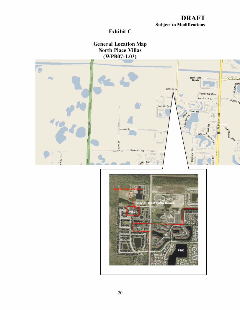
North Place Villas (WPB07-1.03) 3.71 MR5/ PBC MFMD/ WPB South side of 47th Place
North, west of Haverhill Rd. Total: 3.71
Future Land Use Map Amendments 1. (WPB07-1.03): North Place Villas Future Land Use Map Amendment
There are three properties which comprise approximately 3.71 acres of land within an enclave of unincorporated Palm Beach County. The parcels are generally located south of 47th Place and Egret Lake Elementary School and west of Haverhill Road. Under the Palm Beach County Comprehensive Plan, the land use designation is Medium Density Residential which allows 5 du/ac. Under the County’s Transfer of Development Rights Program, the maximum density of the site is 8 du/ac. The proposal is to unify the parcels, annex them into the City and designate the site as Multifamily Medium Density (MFMD). MFMD allows a maximum density of 20 du/ac. The proposed zoning designation, proceeding under a parallel track, is Multifamily 14 (MF14), allowing up to 14 du/ac. The property is contiguous to the City of West Palm Beach on all four sides. The annexation of this property will effectively eliminate the existing pocket of unincorporated area. The existing land use to the north is the Egret Lake Elementary School. The property to the east is designated MFMD and has the Galilee Multifamily Housing Development. The properties to the west are designated Single Family (SF) and are in the Foxhall Subdivision. The properties to the south have FLUM designations of both SF and MFMD.
Key to FLUM Designations City MFMD Multifamily Medium Density County MR 5 Medium Density Residential 5 (5 du/ac)
DRAFT Subject to Modifications
3
Text Amendments 1. (WPB07-1.01): NMUD Building Type III Live/Work Text Amendment
The proposed text amendments to the FLU Element of the Comprehensive Plan modify the description of the uses permitted in the residential incentive program in the Northwood Mixed Use District (NMUD). NMUD regulates using a series of building types, similar to the Downtown Master Plan Element. The residential incentive program allows additional stories in height in exchange for the provision of residential uses in the upper stories. Residential uses are encouraged to provide a mix of uses within the business district and to promote revitalization in the area. The proposed amendments will allow live/work uses as a new option and include a definition of the live/work use. The proposed amendments expand the allowable uses to include Live/Work uses within the third story. In buildings four to five stories in height, the fourth and fifth stories remain restricted to only residential uses. The provision of live/work uses is compatible with the business district and will help diversify investment potential for the area. The area is within a Community Redevelopment Area (CRA). The CRA has conducted two studies including a market analysis that support this amendment.
2. (WPB 07-1.02): Downtown Master Plan (DMP) Element Text Amendment
The area covered by the proposed DMP amendments is shown on Exhibit D. The proposed amendments update the Introduction. The formal Vision for the downtown remains the same. The amendments change the boundaries of and redefine some of the downtown districts (Exhibit F). The Transportation Strategy and Retail Strategy sections are removed and replaced with Goals, Objectives and Policies. The most significant change is the elimination of form-based graphics that define allowable building types and which are used as the method for regulating the scale, height, and intensity of new development (Exhibit G). The amendments propose character descriptions of each district, including the maximum development height. The proposed amendments generally allow for doubling the building height currently permitted.
Extrajurisdictional Impacts The proposed DMP amendments were submitted to the Palm Beach County Intergovernmental Plan Amendment Review Committee and were processed on April 25, 2007. According to the Clearinghouse Coordinator, no objections have been received. Effects on Significant Regional Resources or Facilities Analysis of the proposed amendments indicates there is potential for future adverse effects on significant regional resources or facilities related to the Region’s affordable
DRAFT Subject to Modifications
4
housing supply, the regional transportation network, and the healthy revitalization and infill of downtown West Palm Beach. Analysis of Consistency with Strategic Regional Policy Plan (WPB07-1.03): North Place Villas Future Land Use Map Amendment: The amendment is consistent with the Strategic Regional Policy Plan. (WPB07-1.01): NMUD Building Type III Live/Work Text Amendment: The amendment is consistent with the Strategic Regional Policy Plan. (WPB 07-1.02): DMP Element Text Amendment: The amendment is inconsistent with the Strategic Regional Policy Plan. Downtown Master Plan Element Text Amendments Background The Downtown Master Plan (DMP) Element is a chapter in the Comprehensive Plan dedicated to the City’s vision for growth and redevelopment in downtown West Palm Beach (Exhibit D). Downtown West Palm Beach serves as an important and valuable regional resource within the Treasure Coast Region. From a social, cultural, and economic standpoint, it is perhaps the best opportunity to establish a true “central city” for the Region. It is in essence the central business district for Palm Beach County and a significant economic engine for the Region. The DMP was formally adopted in 1995. The DMP is essentially a “form-based” comprehensive plan element and includes several components:
1) The identification of unique Neighborhoods, Districts and Corridors; 2) A Transportation Strategy intended to reclaim the streets for pedestrians from
fast-moving vehicular throughways, including a parking analysis and maximum allowable development thresholds;
3) A correlating Transportation Concurrency Exception Area (TCEA); 4) A Retail Strategy to return shoppers to Clematis Street that had shifted to
suburban malls; 5) Urban Regulations defining four Building Types and Primary and Regular Street
types. More detailed requirements and illustrations of the plan (i.e. building setback requirements, specific uses, landscaping requirements, etc.), are codified in the Zoning and Land Development Regulations. In November 1994, the TCRPC reviewed amendments to the original adopted DMP Element and found it consistent with the Strategic Regional Policy Plan (SRPP), with the
DRAFT Subject to Modifications
5
exception of fifteen-story buildings proposed for locations other than the Clearlake District or along Okeechobee Boulevard (Exhibit E). The DMP was amended by a voter referendum to limit the waterfront areas to five stories in height, consistent with Council’s recommendation. Since the original plan was adopted, the City has experienced significant and rapid revitalization. The downtown has changed from a largely vacant, decaying area, and has started to emerge as a place for people to live, shop, work, and recreate. The redevelopment of the downtown was fostered largely by the codification of the 1995 DMP and by the City’s investment in CityPlace, a model of the City’s redevelopment vision. Because of the significant role downtown West Palm Beach plays in the region, proposed changes to the City’s plan have been carefully considered by Council within that context. Concerns raised in Council’s analysis are intended to provide constructive input to ensure the City’s redevelopment continues to succeed. Many of the comments and recommendations outlined below are established to point out what may be some unintended consequences of the proposed plan changes, the effect of which may prevent the City from accomplishing its stated objectives. Analysis Council recognizes that over the past decade, several key changes in the downtown warranted the need to review the DMP:
• The effort to renew interest in downtown investment has been very successful in some areas of downtown, while other areas remain distressed.
• Development has not followed the original plan’s expected infill pattern, with whole blocks redeveloped within single projects resulting in a built form the City considers “too boxy” and “massive”.
• The CityPlace project has impacted the retail mix of the downtown. • Significant street improvements have been completed. • The CityPlace development and residential incentive program have resulted in
more than two thousand new downtown residential units. • Clematis Street’s resurgence and decline after the development of CityPlace. • Most new residential units are priced out of reach for median-income households. • New planning studies (Transit Oriented Development charrette, Urban Land
Institute Study, Stull and Lee Report) have fine-tuned plans for specific areas. In 2006, the City contracted Zyschovich, Inc. to evaluate and make recommendations for updating the DMP. The submitted amendments are reflective of the recommendations from this process. Specific concerns regarding the proposed Comprehensive Plan amendments have been identified by Council pertaining to the following key issues:
DRAFT Subject to Modifications
6
1) Lack of policies and strategy to ensure adequate workforce/affordable housing; 2) Lack of policies providing predictable density and intensity; 3) Transportation impacts to the regional roadway network; 4) Lack of a downtown retail strategy, and; 5) Changes to the Transfer of Development Rights (TDR) Program.
1. Workforce/Affordable Housing The City’s success in establishing the downtown as an attractive residential address is commendable, serving as an example of redevelopment for other municipalities and perhaps reflecting a national trend of successful downtown revitalization. However, the redevelopment efforts have resulted in units priced out-of-range for most of the downtown workforce, reflecting a regional trend of gentrification in successful downtown redevelopment efforts. For 2007, Area Median Income (AMI) for West Palm Beach was $61,200 as reported by the U.S. Department of Housing and Urban Development. As such, households earning between 80 and 120 percent of AMI can afford a purchase price between $138,000 and $211,000. Currently, some affordable housing may be available in the few distressed areas and units over $400,000 are plentiful, but housing attainable to the general workforce or median income earners is typically not available within the downtown. Objective 2.4 of the proposed amendments recognize the need for housing accessible to all income levels. Two policies support this objective, including one (2.4.2) referencing non-specific incentives. Additionally, Policy 1.1.1(9) describes the Transit-Oriented Development (TOD) District as an appropriate location for both attainable and market rate housing. The revised Introduction (page 16) indicates a downtown population increase of 41 percent from 2000-2005 and projects a 99 percent increase from 2005-2010. However, the data and analysis submitted for Objective 2.4 in Attachment III references the Lambert Market Study which indicates the housing market appears to be slowing down. These housing forecasts and population projections appear to contradict each other. If a doubling of the current downtown residential population is anticipated in the next five years, what percentage of new residents is expected to live and work downtown? The collocation of housing and workplace is essential to the health of the regional transportation system. The proposed amendments do not contain specific policies to ensure that diverse housing options will occur in the downtown. The City has specified policies including additional height and the use of TDRs to promote office development in the downtown:
• Policy 1.1.1(8) indicates that “additional height is tied to the provision of substantial office space”;
• Policy 2.1.1 lists the TDR Program as an incentive to build office uses within a proposed business district.
Given the submitted data and analysis demonstrating demand for office and the availability of undeveloped sites (125 acres), it is likely the private market will build the
DRAFT Subject to Modifications
7
office supply on vacant lands, without the need for incentives on limited sites. Incentives should be focused on constructing needed attainable housing, without which the private market will not provide. It is critical that attainable housing be constructed within the downtown before the opportunity is eclipsed by rising real estate costs. Recommendations
1. To ensure diverse housing occurs, Policy 2.4.2 should be amended to state that “the City will create attainable and workforce housing within the Downtown” followed by specific actions to achieve the objective. For example:
a. City-owned TDRs will be used as incentives to construct
workforce/affordable housing within the downtown; b. A specific limited-duration FAR/height bonus should be offered in
exchange for dedicated workforce/affordable housing, not for office uses, and;
c. City-owned parcels will be used to build workforce housing.
2. Policies offering incentives for office uses should be removed. 2. Predictable Density and Intensity A. Regulating by Building Type The proposed amendments shift the basic regulating method of downtown development from a Form-based to a “Capacity Driven” approach. The existing form-based regulations in the plan use illustrations as an integral part of the system (Exhibit G and I). The amendments remove all illustrations within the Element, replacing them with text-based descriptions. Form-based regulations are defined by the Form Based Code Institute:
A method of regulating development to achieve a specific urban form. Form-based approach creates a predictable public realm by controlling physical form primarily, with a lesser focus on land use, through city or county regulations.
The success of the current DMP in attracting re-investment in the formerly-blighted downtown area is largely due to the predictability of both physical form and development potential engendered in the current form-based plan. The Urban Regulations in the DMP Element define a palette of four Building Types for redevelopment in the downtown (Exhibit G). The general character, scale, use and height of each type is described and illustrated. The Urban Regulations also include descriptions supported by illustrations identifying appropriate locations for each building type, using the highest degree of specificity for the most intense type. Regulating by Building Types in this manner removes the ability for individual developers to negotiate more height or additional building square footage beyond that
DRAFT Subject to Modifications
8
permitted in the defined type allows. Variances for height are not permitted. Instead, re-zoning to another building type within the public process is the method for increasing density and intensity. Since the Comprehensive Plan describes the appropriate locations for the different types, most changes could not occur without the oversight of a Comprehensive Plan amendment. For example, the use of the fifteen-story “Tower Building” is limited by the statement: “Type IV, the Tower Building, has been designated for all of the Clear Lake District and for both sides of Okeechobee Boulevard.” This methodology stabilized development rights and is the key reason for the success of the City’s two incentive programs, the TDR Program and the Residential Incentive Program, which allowed Type III Buildings to increase their height by three stories for residential uses only above the fifth floor. Under the current form-based system, these programs were the only methods for obtaining additional height or development rights without a Comprehensive Plan amendment. Accordingly, the City secured specific public goods (preservation of historic structures or creation of needed residential units) in exchange for private development rights. The City’s dissatisfaction with the form of new development is one of the concerns that engendered these amendments. All illustrations and the Urban Regulations section are to be removed but not replaced. The proposed methods of regulation (Policy 3.1.2) reference building typologies, however, new or revised types are not identified in the amendments. In order to clarify the city’s preferred form of development new images depicting the city’s preferred development form should be included. B. Regulating by Building Height The proposed amendments to the DMP remove the Urban Regulations including the building types and propose general height limits and character descriptions per the refined districts (Policy 1.1.1). Proposed Policy 3.1.2 states that regulation will be achieved through “use, Floor Area Ratio, building typologies, height and other elements necessary to preserve and enforce the character of each District”. Building heights are the only quantifiable density and intensity measure identified in the proposed amendments. Under proposed Policy 1.1.1 building heights are generally increased. In the downtown core, (Quadrille Garden District, Government Center District, Quadrille Business District, and Transit-Oriented Development District) building heights are doubled from five stories in height to ten. In some areas of the Quadrille Business District and Quadrille Garden District, the amendments triple and quadruple the current height for new construction. For example, under the current plan, Fern Street between Quadrille Boulevard and Olive Avenue is limited to five stories and not eligible for the Tower Building (fifteen stories). In the proposed description of the Quadrille Garden District (which includes this area), building heights will range from ten stories and rise as tall as sixteen stories. The Quadrille Business District, previously four to five stories is now
DRAFT Subject to Modifications
9
proposed to include 25-story buildings. Descriptions of other districts contain non-specific height references. Policy 1.1.1(8) references “stepping down” and 1.1.1(9) suggests “mid-rise” development, leaving the height open to interpretation. A comparison of Exhibits E and E-1 provided in this report illustrates the significant extent of the changes in height proposed for Downtown. The significant height changes raise concerns regarding redevelopment, compatibility, absorption, and predictability. Allowing such dramatic height increases can jeopardize the redevelopment of a downtown still in the early revitalization stages by creating land speculation and concentrating available capital into isolated projects, rather than distributing investment throughout the area. There is no basis in the planning literature or in practice that supports use of excessively tall buildings to redevelop a downtown and many national examples that prove these height increased strategies have been detrimental for downtown redevelopment. Allowing such a large concentration of development during the early stages of downtown’s redevelopment will make those vacant areas in the city’s urban fabric more difficult, if not impossible to fill. Vacant lots are detrimental to a downtown’s viability, pedestrianism, safety and attractiveness. If one or two projects absorb the market demand, as was the practice in the 1980s before the original DMP, redevelopment efforts will stagnate or begin to decline. As indicated in the City’s data and analysis, the downtown still has approximately 125 acres of developable land. There appears to be enough land in the downtown allocated to for nonresidential uses at the existing five and fifteen-story heights to achieve even the most lofty redevelopment goals. The data and analysis suggests a demand of 800,000 square feet of office uses, with 350,000 square feet currently under construction within two projects. The remaining demand of 450,000 square feet could conceivably be absorbed within two projects. Policies that provide incentives for building office uses with an established demand may even be counter-productive in this case. The update that began as an effort to revisit building form and design will have much further-reaching and unintended consequences regarding downtown revitalization. One of the City’s key reasons for these amendments is the dissatisfaction with the poor design of new projects, many encompassing whole blocks. These issues are resolved by limiting maximum lot sizes, increasing architectural guidelines, and/or by implementing a more extensive design review process. The effect of the increased height limits will be higher land cost encouraging land speculation, removing the potential for smaller infill projects, and resulting in “mega-projects” as the only cost feasible development increment. It is not clear how these amendments resolve the originally stated concerns. The heights and development proposed in the TOD District and the Quadrille Business District (Policy 1.1.1) are not consistent with the development analyzed in the West Palm Beach Transit Village Charrette Report. The report was created by Council staff after a week-long charrette in January 2005, which included retail, transportation, economic and design experts. The proposed master plan development included retail, office, government, residential and parking uses, was illustrated and fiscally analyzed. Under the study, 30 percent workforce housing development was determined to be feasible. The
DRAFT Subject to Modifications
10
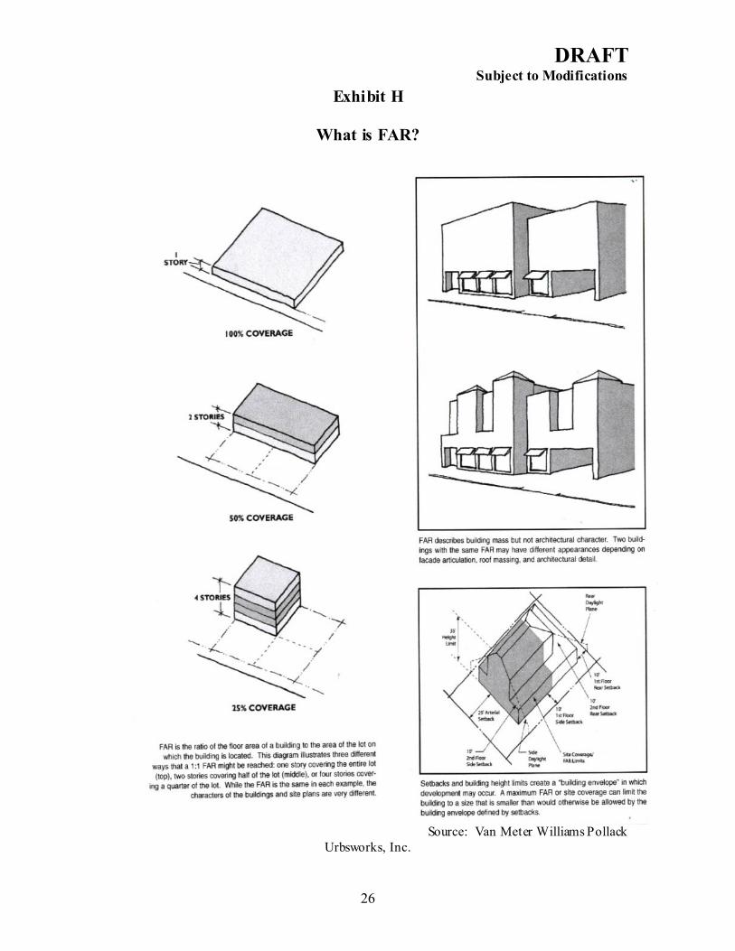
proposed building heights in the submitted amendments are five stories higher along Tamarind Avenue, and fifteen stories higher along Banyan Boulevard than those proposed in the Transit Village Charrette Report. Data and analysis should be submitted to explain the need to increase building heights. Regulating solely by building height in the Comprehensive Plan, without using other measures of density and intensity, opens the plan to interpretation regarding development potential and expectations. Is the height increase a by-right up-zoning or do the current development rights remain the same? What is required to obtain the incentives for increasing development to the maximum height? How is compatibility ensured? The answers to these density and intensity questions should be identified within the Comprehensive Plan. The City’s concern regarding the “conflict between public and private realms” resulting from the new development is not resolved by using a height regulation system with less specificity and no illustrations to guide development. C. Regulating by Floor Area Ratio (FAR) Proposed Policy 3.1.2 states that regulation will be achieved through “use, Floor Area Ratio, building typologies, height and other elements necessary to preserve and enforce the character of each District”. The proposed amendments do not specify the Floor Area Ratio (FAR) that will be used. FAR is the gross floor area permitted on a site divided by the net area of the site, expressed in decimals (Exhibit H). For example, a FAR of 2.0 allows a building with the gross square footage of two times the size of the lot. FAR describes development intensity, but does not address appearance or architectural character, two key concerns the City is attempting to address with these amendments. The appearance of a building depends on other factors including setbacks, height, façade articulation, and placement on the site. Depending on these factors, the same FAR could result in a variety of forms, some desirable and some not desirable for healthy downtown redevelopment. The strategy submitted in support of removing the current form-based system is:
1. Measure the existing development potential of the current building types; 2. Convert this development potential into an FAR; and 3. Code a building envelope larger than the permitted development square footage.
With the quantity of development limited and the potential building envelope increased, the City expects to obtain more creative architecture. It is intended to provide flexibility in how development is arranged on the site and neutralize developers’ inclination to maximize the building envelopes of the current types. The strategy outlined above is not supported by the proposed amendments. The proposed amendments do not specify FAR criteria. Most significant, there is no policy limiting properties to their current development potential. Without this policy statement, the proposed height increases in the amendments could be construed by property owners, investors and developers as increases in density and intensity. If the regulations for
DRAFT Subject to Modifications
11
density and intensity are not in the Comprehensive Plan, the ability of the City to carry out its incentive programs (Policy 2.4.2), use the TDR program (Policy 2.1.1), and foster architectural creativity will be weakened. D. Compatibility The proposed amendments state the intent to reinforce the character of each district. It is unclear how the City will be able to ensure compatibility between old and new structures given the proposed height increases (Policy 1.1.1). Illustrations are not submitted to demonstrate the compatibility of the proposed building heights in regard to either existing development intended to remain or along existing streets (Policy 3.2.2). Policy 4.3.2 proposes the strategic location of parking garages to maintain the integrity of the urban fabric. In the proposed Quadrille Garden District, existing two-story vernacular buildings are encouraged to remain adjacent to new ten-story construction. The “low-scale residential…not available elsewhere in the downtown” within the CityPlace District will now abut proposed ten-story development in the Quadrille Business District, an area previously intended to develop at a similar scale as CityPlace. The Banyan Boulevard corridor in the Quadrille Business District calls for 25-story development which transitions within a block into a historic single-family neighborhood of one and two-story houses. The necessary parking garages to accommodate the new development intensity will create impacts beyond the towers themselves, which conflicts with proposed Policies 1.1.1 and 4.3.2. The proposed height increases may remove the very character of the districts the City intends to maintain. The shift in regulatory methods seems contrary to the City’s intention to improve “the conflict between the private and public realm” created by new development. The specific tools that the city will rely upon (FAR, Building Types, Street Types, Architectural Guidelines and Parks Plan) are listed, but not sufficiently detailed beyond height to ensure the City’s concerns will be resolved. The amendments do not clearly illustrate how the downtown vision is intended to build out, how identified compatibility issues will be resolved, or how existing capacity will be allocated under the proposed Capacity Driven system. Recommendations
1) Data and analysis demonstrating the calculation of the FAR amount per building type should be provided. Sufficient development has occurred under the existing master plan to measure the potential build out of the original building types in FAR.
2) The existing “entitlements” by FAR should be clearly identified in the Comprehensive Plan. The existing development potential is different for properties depending upon the current building type designation and specific location. For example, properties that have a Building Type II designation
DRAFT Subject to Modifications
12
(townhouse) have less density and intensity potential than those with a Building Type IV (fifteen-story) designation.
3) A policy should be added clearly stating the current density and intensity (in the desired FAR method) for downtown properties does not increase, except by the use of specifically defined incentive programs.
4) Policies 2.1.1 and 2.4.2 are vague in describing the incentives the city will offer. The policies should state if, and how much, bonus FAR and/or height will be offered in support of specific objectives.
5) Data and analysis should be submitted or new policy provided to demonstrate how the office demand will not be absorbed in one or two buildings under the proposed height increases.
6) The use of diagrams and illustrations is encouraged to clarify the City’s redevelopment vision and to ensure compatibility issues can be resolved.
7) Policy 3.2.3 should indicate a timeframe in which the City will establish an architectural review board.
3. Transportation & the Transportation Concurrency Exception Area (TCEA) The implementation of the DMP is tied to compliance with the TCEA designation for the downtown. The TCEA designation allows new development without requiring widening of existing streets or the provision of new streets. The TCEA depends on the combination of an urban development pattern, existing infrastructure and a balance of residential and nonresidential uses for success. The intent is to achieve internal vehicular trip capture and the use of alternative modes of transportation (walking, bicycling, and transit) within the area. As such, policies in the City’s Transportation Element are interrelated with the City’s DMP Element. The proposed Capacity Driven system calls for regulating using the development capacity cap of the downtown’s TCEA. Policy 2.2.5(h) of the City’s Transportation Element regulates maximum amounts of both residential and nonresidential development permitted within downtown. In 1995, residential development was needed to balance the established office uses in the area. As such, TCEA policies in the City’s Transportation Element specifically encourage increasing residential use in the downtown in order to achieve a healthy balance of uses (Policy 2.2.5(i)). TCEA policies require measuring the ratio of residential to nonresidential uses at certain time periods to monitor progress. A ratio of .46 residential units to 1000 square feet of commercial is the overall objective (Policy 2.2.5(i)). The proposed policies for the DMP Element offering incentives for office development conflict with the current policies in the Transportation Element. The City has not provided data and analysis to prove the ultimate balance of uses required in the TCEA policies has been reached or exceeded. Another consideration is that while the TCEA ratio has mathematically improved over time, the prices of new residential units are out-of-reach for those downtown workers earning median income salaries preventing the full objectives of the TCEA from being reached. Before incentives are offered to promote additional office uses, a Jobs-to-Housing analysis demonstrating downtown housing
DRAFT Subject to Modifications
13
options are available for downtown workers and documentation that the TCEA ratio is .46 or higher should be provided. The City states overall downtown development will not exceed the TCEA cap. However, if incentives are piled on to certain sites, the result will be either
a. a city left with holes in its fabric when the permitted development potential is exhausted, compromising both the walkability of downtown and the intent of the TCEA, or
b. the necessity to increase overall density and intensity beyond the current TCEA criteria.
Adequate data and analysis has not been provided to prove that the proposed height increases can be achieved without impacting the density and intensity permitted by the TCEA. The proposed increases in height and office uses pose additional transportation impacts along the main corridors. Banyan Boulevard provides one of two east-west access points into the downtown core. It is not demonstrated that the roadway network will be able to accommodate the increase to 25-story non-residential development along Banyan Boulevard (Policy 1.1.1). Proposed Policy 4.2.5 states the City will assist with and encourage adoption and implementation of South Florida East Coast Corridor (SFECC) study, which seeks to provide public transit options within the existing FEC railroad corridor. The SFECC Study currently underway recommends the possibility of reactivating the abandoned rail line north of Banyan Street, running along 2nd Street to make a “hard-line” connection between the FEC and CSX tracks at the Seaboard station. It is unclear how both the proposed 25-story offices (Policy 1.1.1) and this transportation goal can be physically accommodated. The Transportation Element Policy 2.2.5(e) requires large employers to provide Transportation Demand Management activities. The proposed amendments include a new office corridor and define two business districts. Proposed Policy 4.2.3 encourages the provision of amenities such as bicycle racks and showers in the downtown. Given the proposed intense office districts, the Policy 4.2.3 should require, not encourage, these amenities. Recommendations
1) Policies offering incentives for office uses should be removed unless data and
analysis is submitted demonstrating the ultimate balance between residential and office uses required by the TCEA policies has been exceeded.
2) Data and analysis should be submitted demonstrating the Jobs-to-Housing Ratio in the downtown is sufficient to achieve the expected trip capture before providing incentives for office uses.
DRAFT Subject to Modifications
14
3) Table 16-1 should be revised to reflect the new districts and to document enough development remains in the TCEA to achieve infill throughout the downtown with the required balance of uses.
4) Conflicts between the Transportation Element and Downtown Master Plan Element should be resolved.
5) The City should include policy language requiring accommodations for bicyclists within new office development to support both the intent of the TCEA (Policy 2.2.5(e)) and regional goals.
6) The City should submit data and analysis demonstrating the ability to implement both the recommendations of the SFECC Study (Policy 4.2.5) and the heights permitted in Policy 1.1.1(8).
4. Retail Strategy In spite of the success of downtown development, the City’s historic main street, Clematis Street, is struggling. The City is investing in the street, building a new library between Quadrille Boulevard and Dixie Highway and providing a new waterfront park on Flagler Drive on the site of the old library. The proposed amendments remove the previous Retail Strategy in its entirety and add two general retail policies. Policy 2.2.1 identifies the Downtown Development Authority (DDA) and the CRA as entities to promote retail businesses along Clematis Street and Rosemary Avenue, and Policy 2.2.3 states that uses that supporting the downtown residential uses will be encouraged. Certainly the Retail Strategy section of the original plan and the supporting policies (Policy 2.1.1) require updating to respond to the impact of the CityPlace development, but the strategy has been removed without providing new policy direction for Clematis Street. This omission creates a void in the plan and could compromise the ability to achieve an interdependent and sustainable mix of uses. Recommendations
1) Data and analysis should be submitted indicating historic retail trends since the adoption of the 1995 plan as well as the current retail market.
2) Specific policies and actions should be included that encourage the revitalization of Clematis Street in the current retail market.
5. Transfer of Development Rights The TDR Program was established in 2001 as a tool to implement the historic preservation ordinance and to facilitate the creation of public parks as downtown property values rose. The program has been successful to date, contributing to the preservation of fourteen historic buildings. The proposed text amendments expand the program as a tool to preserve new “historic conservation districts”. These districts are intended to protect areas that do not qualify for formal historic designation, but are nonetheless valuable to the community for their scale and character. To ensure the integrity of the program and to further protect historic
DRAFT Subject to Modifications
15
buildings and the proposed conservation districts, Policy 1.3.3 should be amended to list these districts as appropriate sending sites and to indicate they will not be eligible receiving areas. As downtown real estate values continue to increase in value, the TDR Program allows for the creation of new parks which would otherwise be cost-prohibitive. As such, the program should be identified under Objective 1.4. Policy 1.4.1 states the city will create a comprehensive parks and open space plan identifying locations for preferred parks. A timeframe for this plan should be included in the policy. A supporting policy indicating parks in this plan as appropriate sending sites in the TDR Program should be added. According to the data and analysis, the City has transferred over 259,000 sf of development from the “Downtown Gate Park”, an unimproved parcel located on Okeechobee Boulevard and Australian Avenue at the entrance to downtown. However, the City has established a questionable planning precedent by transferring development credits before providing the basic amenities of a public park. There should be a reasonable timeframe specified in a policy tied to when public park improvements will occur on active sending sites. Under these amendments, the TDR program will be used to fill the intensity gaps from ten stories to sixteen stories and, in some locations, up to 25 stories. Data and analysis should be submitted demonstrating a sufficient supply of TDRs exists. Offering significant additional height without an adequate TDR supply to can lead to land speculation and undermine redevelopment efforts. Recommendations:
1) Amend Policy 1.3.3 to indicate historic sites/conservation properties will not be eligible receiving sites;
2) Include a policy under Objective 1.4 indicating the use of the TDR Program for the creation of public open space identified in the plan proposed by Policy 1.4.1.
3) Provide a timeframe in Policy 1.4.1 for a comprehensive parks plan including when public park improvements will occur on park lands where development credits have been transferred.
4) Submit data and analysis demonstrating a balance between proposed sending sites and receiving areas to justify the offered height increases.
Consistency with Strategic Regional Policy Plan The contract agreement between the DCA and the Treasure Coast Regional Planning Council requires Council to include a determination of consistency with the SRPP as part of the written report to be submitted to the DCA. Council finds the proposed Future Land Use Map amendment and text amendments to the Northwood Mixed-Use District to be CONSISTENT with the SRPP. Council finds the proposed amendments to the Downtown Master Plan Element to be INCONSISTENT with the SRPP, especially as they relate to:
DRAFT Subject to Modifications
16
1) Regional Goal 2.2 calls for a range of housing types and affordabilities in proximity
to employment and services. SRPP Policy 7.1.3.4(2) states that housing opportunities close to employment opportunities are necessary to achieve Regional Goal 7.1, a balanced and integrated transportations system. The amendments do not contain adequate policies to ensure a range of housing affordabilities will occur within the downtown;
2) SRPP Policy 15.1.3.1 calls for increasing the clarity of local land use plans. The
departure from the form-based comprehensive plan to an undefined FAR program and the potential confusion for how much development potential is permitted on downtown properties does not support this intent.
3) Regional Goal 5.1 is to revitalize and infill existing neighborhoods and districts. The
amendments do not contain adequate polices or supporting data and analysis to ensure the proposed increases in height will not result in the agglomeration of significant land use intensities in one area without compromising the ability to infill the entire downtown.
4) Regional Goal 7.1 is a balanced and integrated transportation system. SRPP Policies 7.1.3.5 and 7.1.3.9 support enhanced pedestrianism to encourage alternate modes of transportation. Data and analysis should be submitted to demonstrate the proposed amendments are not in conflict with the policies of the TCEA and that the maximum density and intensity in the TCEA are unaffected.
5) SRPP Policy 5.1.1.6 is to encourage the redevelopment and revitalization of historic main streets. The City should update the downtown master plan retail strategy for consistency with this policy.
Recommendation Council should adopt the above comments and approve their transmittal to the Department of Community Affairs. Attachments
DRAFT Subject to Modifications
17
DRAFT Subject to Modifications
18
Exhibit A
General Location Map City of West Palm Beach
City of West Palm Beach
DRAFT Subject to Modifications
19
Exhibit B
General Location Map Northwood Mixed Use District (NMUD)
DRAFT Subject to Modifications
20
Exhibit C
General Location Map North Place Villas
(WPB07-1.03)
DRAFT Subject to Modifications
21
Exhibit D
Downtown Master Plan Element Boundaries
DRAFT Subject to Modifications
22
Exhibit E
Areas 15-20 Story Buildings Currently Permitted (Denoted in Red)
Clearlake District
DRAFT Subject to Modifications
23
Exhibit E-I
Areas Proposed for 15-25 Story Buildings - Denoted in Red Areas Proposed for 10-Story Buildings - Denoted in Blue
DRAFT Subject to Modifications
24
Exhibit F
Proposed New Districts
DRAFT Subject to Modifications
25
Exhibit G
Building Types
DRAFT Subject to Modifications
26
Exhibit H
What is FAR?
Source: Van Meter Williams Pollack
Urbsworks, Inc.
DRAFT Subject to Modifications
27
Exhibit I
Figure 16-9 City of West Palm Beach Master Plan 1993