Submission from Cressbrook Creek Water Advisory Committee.doc Page 1 of 4 September 1st 2006 P O Box 49 Toogoolawah Qld 4313 1 SUBMISSION TO THE DRAFT W ATER RESOURCE (MORETON) PLAN. Issues of Concern regarding the Moreton Water Plan from the Cressbrook Creek Water Advisory Committee and members. 1.1 Allocation Amount and Hydrology Report 1.1.1 ALLOCATION AMOUNT The Committee challenges the accuracy of the “Review Of Cressbrook Project” (prepared by the Department of Natural Resources, April 1996) which is referenced in the Moreton Draft Water Resource Plan. For example the following statement “Underground water is recharged through direct rainfall infiltration and stream flow in Cressbrook Creek.” is incorrect in that direct rainfall infiltration only occurs when the creeks flow into the Cressbrook Creek watercourse. This has occurred only 3 to 4 times since the dam was built in 1982. Currently the aquifer is only ever recharged from the yearly release of our allocation and is never completely recharged. In John Oxenford’s report of 1980, he stated “These aquifers rely entirely on creek run-off for recharging”. Also the 1996 Report states on page 21 9.0 Conclusions that the release should be at least 2750 megalitres. This equates to approximately 12% of the inflows as stated by John Oxenford and Associates Ltd Consulting Engineers in his “Analysis of Observations” of May 2005. This document recommends that this flow be increased to 28% of total inflows as per the rehabilitation of the Snowy River. This 28% equates to 6416 megalitres. In John Oxenford’s report of 1980 (before the dam was built) he stated “that two-thirds of the flow is to be directed elsewhere (Toowoomba City Council) and only one-third will be available for irrigation and/or recharging local aquifer. It is my experience that this would not be sufficient to saturate such aquifers.” He then observes that the water table would be lowered and salinity would increase. John has been quite prophetic. The “Order In Council” of 1981 recommended a release up to 142 litres per second which equates to 4481 megalitres. We therefore maintain that the figure of 2750 megalitres is completely inadequate. Cressbrook Creek Water Advisory Committee
Transcript
Submission from Cressbrook Creek Water Advisory Committee.doc
Page 1 of 4
September 1st 2006
P O Box 49 Toogoolawah Qld 4313
1 SUBMISSION TO THE DRAFT WATER RESOURCE (MORETON) PLAN.
Issues of Concern regarding the Moreton Water Plan from the Cressbrook Creek Water Advisory Committee and members.
1.1 Allocation Amount and Hydrology Report
1.1.1 ALLOCATION AMOUNT
The Committee challenges the accuracy of the “Review Of Cressbrook Project” (prepared by the Department of Natural Resources, April 1996) which is referenced in the Moreton Draft Water Resource Plan. For example the following statement “Underground water is recharged through direct rainfall infiltration and stream flow in Cressbrook Creek.” is incorrect in that direct rainfall infiltration only occurs when the creeks flow into the Cressbrook Creek watercourse. This has occurred only 3 to 4 times since the dam was built in 1982. Currently the aquifer is only ever recharged from the yearly release of our allocation and is never completely recharged. In John Oxenford’s report of 1980, he stated “These aquifers rely entirely on creek run-off for recharging”. Also the 1996 Report states on page 21 9.0 Conclusions that the release should be at least 2750 megalitres. This equates to approximately 12% of the inflows as stated by John Oxenford and Associates Ltd Consulting Engineers in his “Analysis of Observations” of May 2005. This document recommends that this flow be increased to 28% of total inflows as per the rehabilitation of the Snowy River. This 28% equates to 6416 megalitres. In John Oxenford’s report of 1980 (before the dam was built) he stated “that two-thirds of the flow is to be directed elsewhere (Toowoomba City Council) and only one-third will be available for irrigation and/or recharging local aquifer. It is my experience that this would not be sufficient to saturate such aquifers.” He then observes that the water table would be lowered and salinity would increase. John has been quite prophetic. The “Order In Council” of 1981 recommended a release up to 142 litres per second which equates to 4481 megalitres. We therefore maintain that the figure of 2750 megalitres is completely inadequate.
Cressbrook Creek Water Advisory Committee
Submission from Cressbrook Creek Water Advisory Committee.doc
Page 2 of 4
1.1.2 HYDROLOGY REPORT The Committee would like to see an independent hydrology report of Cressbrook Creek as stated by John Oxenford in his 2005 report quote, “I recommend that a review be undertaken to compare pre- and post- disturbance conditions along Cressbrook Creek to determine what other degradations may (or may not) have occurred as a result of the construction of Cressbrook Dam.” In John Oxenford’s 1980 Report he states “That an Environmental Impact Statement which should normally be prepared for a project of this magnitude” The Committee has no knowledge of any Environmental Impact Statement being completed. 1.1.3 ATTACHMENTS
JOxenfordAssocCressbrookCreek_30thMay2005.doc Order In Council.doc JOxenford1980Letter.doc
1.2 Release Strategy The Committee asserts that it should have input into the actual release strategy of water from Cressbrook Dam due to the haphazard release mechanism used in the past.
1.3 Accurate Pumping Figures The Committee would like Toowoomba City Council to make the pumping figures from Cressbrook and Perseverance Dams available and be required to keep accurate figures of the water volumes used for Toowoomba City Council and the surrounding areas including any on-sale of water to Oakey or other towns’ users.
1.4 Urban Water Users Preference The Committee rejects outright any suggestion that urban water users, either industrial or domestic, should be given any preference by the Government Moreton Water Plan over primary producers in the allocation of available water.
1.5 Businesses and Livelihoods The Committee asserts that riparian users are completely reliant on water flows down the creek to maintain their businesses and livelihoods. They have considerable funds invested in their water infrastructure and according to the SEQ Regional Plan farming areas are to be maintained.
Cressbrook Creek Water Advisory Committee
Submission from Cressbrook Creek Water Advisory Committee.doc
Page 3 of 4
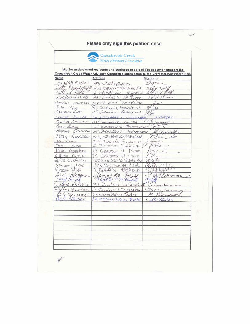
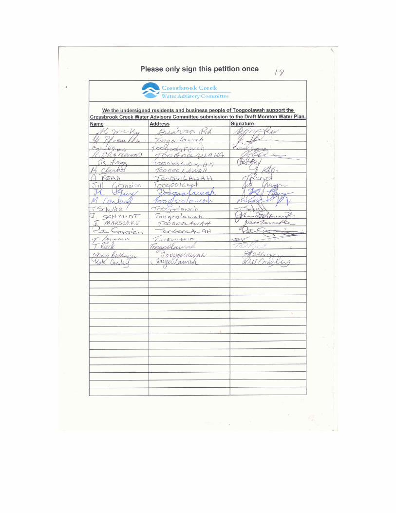
1.6 Negative Financial Impact If riparian users aren’t given sufficient water with the change to volume-metric licences, their productivity will fall causing a negative financial impact on their farming business and surrounding town. Local concern is noted by the attached petition and covering letter by the Toogoolawah Chamber of Commerce.
1.7 Required Megalitres per Hectare With regard to the conversion to volumetric licences the Committee maintains that the 4.2 megalitre per hectare is insufficient and attaches accurate farm records supplied by a local irrigator on Cressbrook Creek and a report on “Water use on Crops and Pastures” from the Mutdapilly Research Station. These reports show that around 10 megalitres per hectare is required for most crops. 1.7.1 ATTACHMENTS
1.8 Water Trading The Committee is not in favour of water trading on Cressbrook Creek. There is not enough surface or aquifer water to justify any trading of water. If water trading was allowed then a case could be stated that some users could monopolise the available water to the detriment of the many small farms that rely on what water is available for stock and domestic uses. One could say that Toowoomba City council is already doing this.
1.9 Toowoomba City Council’s Allocation The committee agrees that Toowoomba City Council’s allocation of water will be reduced from 18 636 mega litres to 10 000 mega litres in the proposed time frame.
1.10 Underground Aquifer Recharge The Committee believes the creek system should have a wet stream bed for the environmental and riparian users. As the top half of the creek has no underground aquifer and land holders in this area would benefit from having a slow stream release to ensure stock and domestic water supply. The lower section of the creek would benefit as the alluvial aquifer would be recharged. To achieve a wet stream bed 28% of the inflows needs to be returned to the Creek system. This is reinforced by the numerous submissions made to Department Ministers highlighting that the 2750 megalitre allocation for the creek is insufficient for riparian and environmental needs.
Cressbrook Creek Water Advisory Committee
Submission from Cressbrook Creek Water Advisory Committee.doc
Page 4 of 4
1.11 Future Water Restrictions The Committee would like the Moreton Water Plan to include provision for urban water restrictions to be continued permanently even when there is an abundance of water.
1.12 Ecology and Rehabilitation Officer As the Creek has not had a full flush of water since the Cressbrook Dam was built there has been a prolific build-up of weeds and noxious trees in the stream bed itself. This needs to be addressed as there will be much environmental damage to the stream banks and infrastructure (i.e. bridges) whenever the Creek next floods. Since the Cressbrook Dam was built the environmental damage has been extensive as noted by John Oxenford in his Report of 1980. “The effect on flora and fauna will be quite marked. A new group of flora and fauna will evolve along the watercourse which would be more suited to the new environment – i.e. one which rarely floods and will occasionally dry up completely.” The report states: “For the most part it will be a series of water holes”. This has eventuated to the extent that now the creek for large sections is completely dry. With regard to the rehabilitation of the Snowy River in NSW the NSW State Government has appointed a Rehabilitation Officer. The Committee asserts that the Qld Government should follow suit. 1.12.1 ATTACHMENTS
1.13 Time To Lodge Submissions The Committee believes that the time given to lodge submissions for the Moreton Draft Resource Plan is inadequate for gathering and preparing of details for this submission.
1.14 All Attachments CCWAC_Submission.doc
HendersonMeteredWaterUse.xls HendersonMeteredWaterUseGraphs.doc JOxenford1980Letter.doc JOxenfordAssocCressbrookCreek_30thMay2005.doc MutdapillyResearchWaterUse.jpg Order In Council.doc ResidentsAndBusinessPetitionInSupport.doc RiparianLandholdersSignatures.doc SnowyGoesWithTheFlowArticle.pdf ToogoolawahChamberOfCommerceLetter.doc
Cressbrook Creek Water Advisory Committee
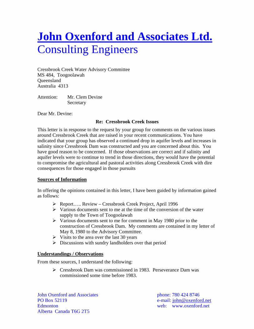
John Oxenford and Associates Ltd. Consulting Engineers Cressbrook Creek Water Advisory Committee MS 484, Toogoolawah Queensland Australia 4313 Attention: Mr. Clem Devine
Secretary Dear Mr. Devine:
Re: Cressbrook Creek Issues This letter is in response to the request by your group for comments on the various issues around Cressbrook Creek that are raised in your recent communications. You have indicated that your group has observed a continued drop in aquifer levels and increases in salinity since Cressbrook Dam was constructed and you are concerned about this. You have good reason to be concerned. If those observations are correct and if salinity and aquifer levels were to continue to trend in those directions, they would have the potential to compromise the agricultural and pastoral activities along Cressbrook Creek with dire consequences for those engaged in those pursuits Sources of Information In offering the opinions contained in this letter, I have been guided by information gained as follows:
Report….. Review – Cressbrook Creek Project, April 1996 Various documents sent to me at the time of the conversion of the water
supply to the Town of Toogoolawah Various documents sent to me for comment in May 1980 prior to the
construction of Cressbrook Dam. My comments are contained in my letter of May 8, 1980 to the Advisory Committee.
Visits to the area over the last 30 years Discussions with sundry landholders over that period
Understandings / Observations From these sources, I understand the following:
Cressbrook Dam was commissioned in 1983. Perseverance Dam was commissioned some time before 1983.
John Oxenford and Associates phone: 780 424 8746 PO Box 52119 e-mail: [email protected] Edmonton web: www.oxenford.net Alberta Canada T6G 2T5
When the Cressbrook Dam was commissioned, flow discharged into Cressbrook Creek was limited to about 2520 megalitres per year. This was subsequently increased to 2750 megalitres after the release of the 1996 Review. The 1996 Review estimates (p17) that the total flow in Cressbrook Creek / Perseverance Creek system is about 23,000 megalitres per year based on data collected from 1966 to 1978. The discharge is therefore about 12% of the total flow.
The operating rules for Perseverance Creek Dam called for the release of between 500 and 1000 megalitres per year to Cressbrook Creek. These release requirements would seem to now form part of the allocation from Cressbrook Dam.
There has been no significant increase in agricultural intensity in the Cressbrook alluvial area that might have increased agricultural consumption of water. This consumption is estimated in the Review (p18) at about 3600 megalitres per year from underground sources and 1000 megalitres from surface.
Landholders comment that since Cressbrook Dam was commissioned, Cressbrook Creek does not flow except for very occasional short periods of maybe 24 hours or less and then only once or twice a year
The supply of water to the Town of Toogoolawah was converted from bores along the Esk – Toogoolawah Road to a supply from Wivenhoe Dam
There has been no major earthworks or other civil works that would divert runoff that would normally have flowed into Cressbrook Creek
Landholders comment that aquifer levels have dropped over the period since Cressbrook Dam was commissioned. Especially in the sections AMTD 23 to AMTD 0. This is confirmed in the Review (p3).
Landholders comment that salinity levels have also increased since Cressbrook Dam was commissioned. I cannot find any data to support or refute this in the Review
There has been no profound change in precipitation levels during this period. Analysis of Observations Before offering an opinion on the cause of these conditions and suggesting some options that might remediate them, I have tried to determine from all the information I have been given what has changed in this period. I find no evidence that consumption has increased significantly. Agricultural intensity in the sections AMTD 23 to AMTD 0 is essentially unchanged. Admittedly, there has been some increase in population density, but this underground water is too saline for human consumption so that population increase will have had little impact. In fact, with the conversion of Toogoolawah to Wivenhoe Dam water, it could be argued that overall consumption may have even decreased. The information provided to me does not indicate that there has been any significant diversion of runoff away from Cressbrook Creek into dams or other uses. So recharge rates should be unaffected. And there has been no significant change in precipitation levels to affect recharge rates either.
John Oxenford and Associates phone: 780 424 8746 PO Box 52119 e-mail: [email protected] Edmonton web: www.oxenford.net Alberta Canada T6G 2T5
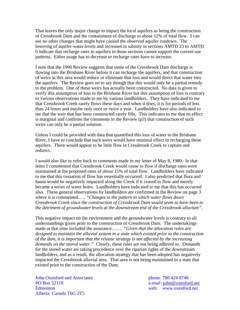
That leaves the only major change to impact the local aquifers as being the construction of Cressbrook Dam and the containment of discharge to about 12% of total flow. I can see no other changes that might have caused the observed aquifer rundown. The lowering of aquifer water levels and increases in salinity in sections AMTD 23 to AMTD 0 indicate that recharge rates to aquifers in those sections cannot support the current use patterns. Either usage has to decrease or recharge rates have to increase. I note that the 1996 Review suggests that some of the Cressbrook Dam discharge is flowing into the Brisbane River before it can recharge the aquifers, and that construction of weirs in this area would reduce or eliminate that loss and would direct that water into the aquifers. The Review goes on to say though that this would only be a partial remedy to the problem. One of these weirs has actually been constructed. No data is given to verify this assumption of loss to the Brisbane River but this assumption of loss is contrary to various observations made to me by various landholders. They have indicated to me that Cressbrook Creek rarely flows these days and when it does, it is for periods of less than 24 hours and maybe only once or twice a year. Landholders have also indicated to me that the weir that has been constructed rarely fills. This indicates to me that its effect is marginal and confirms the comments in the Review (p3) that construction of such weirs can only be a partial solution. Unless I could be provided with data that quantified this loss of water to the Brisbane River, I have to conclude that such weirs would have minimal effect in recharging these aquifers. There would appear to be little flow in Cressbrook Creek to capture and redirect. I would also like to refer back to comments made in my letter of May 8, 1980. In that letter I commented that Cressbrook Creek would cease to flow if discharge rates were maintained at the proposed rates of about 15% of total flow. Landholders have indicated to me that this cessation of flow has essentially occurred. I also predicted that flora and fauna would be negatively impacted along the Creek if it ceased to flow and merely became a series of water holes. Landholders have indicated to me that this has occurred also. These general observations by landholders are confirmed in the Review on page 3 where it is commented….. “Changes to the pattern in which water flows down Cressbrook Creek since the construction of Cressbrook Dam would seem to have been to the detriment of groundwater levels at the downstream end of the Cressbrook alluvium”. This negative impact on the environment and the groundwater levels is contrary to all understandings given prior to the construction of Cressbrook Dam. The undertakings made at that time included the assurance…… “Given that the allocation rules are designed to maintain the alluvial system in a state which existed prior to the construction of the dam, it is important that the release strategy is not affected by the increasing demands on the stored water.” Clearly, these rules are not being adhered to. Demands for the stored water are taking precedence over the riparian rights of the downstream landholders, and as a result, the allocation strategy that has been adopted has negatively impacted the Cressbrook alluvial area. That area is not being maintained in a state that existed prior to the construction of the Dam.
John Oxenford and Associates phone: 780 424 8746 PO Box 52119 e-mail: [email protected] Edmonton web: www.oxenford.net Alberta Canada T6G 2T5
So based on the information provided to me, I have to conclude that an increase in discharge rates is the only solution to this problem. More weirs are just a partial solution. Just what those release rates should be increased to is debateable. Clearly the current rate of 12% is too low to prevent negative impacts in the Cressbrook alluvium area. I have reviewed the calculations in the Review (p19 and Appendix B) that are used to justify the current release levels. These calculations include some factors which are introduced without any data to support them – namely losses between the Dam and the alluvial area of 9 megalitres per day and a recharge rate of 80%. The loss of 9 megalitres is attributed to a “Toowoomba City Council Report” but that data is not provided nor is any specific report cited that I could refer to in order to verify this number. The recharge rate of 80% is noted in Appendix B as being …… “based on water balances carried out in other alluvial areas elsewhere in the state”. Again, no data is provided and no reports are cited. These factors are most crucial in the calculation of discharge volumes and because I can find no data to support those assumptions I have no option but to place very little reliance on them. In addition, the loss of water to the Brisbane River would appear to have been ignored in these calculations. Because of these uncertainties and omissions, I have no option but to place very little reliance on the calculated discharge requirements. The Review makes the comment (p23) that……. “the data available on which to base an assessment is less than ideal”. I would certainly concur with that statement. Elsewhere in Australia, I note that in their efforts to resolve the environmental degradation that has occurred in the Snowy River, the Australian, Victorian and New South Wales Governments have agreed on a discharge rate of 28% of total flow. Please see the attached article on the subject. That is probably a good starting point for the rehabilitation of Cressbrook Creek. I see no reason why that system should be considered to be any different to the Snowy River system. I would therefore most strongly recommend to you and your group that you seek to have discharge rates increased to the Snowy River rates (ie a minimum of 28% of total flow) and that you ensure periodic measurements of salinity and aquifer levels are taken to see if that improves the situation. I would caution though, that these discharge rates need to be increased over an extended period to ensure the aquifers can rebuild. That rebuild process will not occur overnight. Finally, I would comment that all the discussions in the 1996 Review focus only on the maintenance of aquifer levels. If a project such as Cressbrook Dam were to be implemented here in Alberta, an Environmental Impact Assessment (EIA) would have to be prepared by the Applicant before any approval could be given by Alberta Environment and/or the Natural Resources Conservation Board. Among other things, an EIA would benchmark in some detail the conditions that existed prior to the disturbance. This would not be restricted just to aquifer levels but would include flora and fauna distribution, groundwater quality, potential social impacts, surface runoff levels, and so on. The Applicant would then be required to provide periodic compliance reports (generally every 5 years) to maintain their Licence-to-Operate. I assume a study equivalent to an EIA has been prepared for Cressbrook Dam and environs. I would therefore strongly recommend to your group that you access that document and ask for some comparison of pre- and
John Oxenford and Associates phone: 780 424 8746 PO Box 52119 e-mail: [email protected] Edmonton web: www.oxenford.net Alberta Canada T6G 2T5
post-disturbance conditions so that you can assess the impact of Cressbrook Dam on the local environment and not just its impact on aquifer levels. Conclusions and Recommendations So, in summary, my conclusions and recommendations are:
The Cressbrook Creek alluvium area has been negatively impacted by the Cressbrook Dam release strategy that has been adopted. This area is not being maintained in a condition that existed prior to the construction of the Dam.
The remediation action undertaken (namely the construction of a weir in the Toogoolawah Township area to assist in aquifer recharge) has not, and cannot, resolve the issue. At best this can only be a partial solution.
I recommend that release rates be increased to those that have been agreed to for the rehabilitation of the Snowy River (ie 28% of total flow). That release level has been established by some of Australia’s most eminent scientists, hydrologists, and conservationists and sets a benchmark that should be followed in other river systems.
I recommend that a review be undertaken to compare pre- and post- disturbance conditions along Cressbrook Creek to determine what other degradations may (or may not) have occurred as a result of the construction of Cressbrook Dam.
I hope you find these comments of assistance. Please feel free to contact me at any time if I can be of further assistance. Yours truly John Oxenford P.Eng., FAusIMM Principal John Oxenford and Associates
John Oxenford and Associates phone: 780 424 8746 PO Box 52119 e-mail: [email protected] Edmonton web: www.oxenford.net Alberta Canada T6G 2T5
Snowy goes with the flow - National - smh.com.au http://www.smh.com.au/news/National/Snowy-goes-with-the-flow/...
1 of 3 5/13/05 10:16 PM
Snowy goes with the flowMay 14, 2005The mighty river is slowly regaining its strength after years of neglect, writes James Woodford.APPROACHING the tangled banks of the Snowy River, deep in the Kosciuszko National Park'sByadbo Wilderness, there is a noise not easily forgotten.It is the sound of rushing, clear water as it passes over cobblestoned rapids - music to the ears ofthose who have fought to save Australia's most famous inland waterway.It is just under three years since the release of the first environmental flows into the river and expertssay there are early signs of recovery.Most significantly, the extra water is beginning to carve its way through the mountains of swampy,stagnant sediment that accumulated along almost the entire length of the river after four dams werebuilt on it.As the Snowy begins to flow colder, deeper and faster than it has for nearly four decades, the newlyestablished Southern Rivers Catchment Management Authority is racing to bring the river back to life.A Snowy River rehabilitation project officer with the authority, Danny Henderson, says the fact littlefloods are getting through means there is a more definite channel forming.It was a fairly big, swampy, broad channel, Henderson says. "I suppose you could say the SnowyRiver is now looking like a pretty good little creek, and with more time and water it will be a healthyriver - similar to what it was but on a smaller scale."Since 1967, 99 per cent of the river's water has been diverted to the Snowy Mountains Hydro-ElectricScheme, regarded as the nation's greatest engineering feat but one which effectively killed a nationalicon.Then in 2000, under immense political pressure, ecology joined technology at the negotiating table andthe Victorian, NSW and Federal governments agreed to restore as much as 28 per cent of theSnowy's original flows.On August 28, 2002, the Mowamba River Weir was spilled, releasing back into the Snowy the firstenvironmental flow of 128 million litres.In her book Snowy River Story, the Age reporter Claire Millar describes that historic moment: "Itseemed to take forever, but slowly, slowly, the water behind the weir rose. A dribble tinkled over thewall at the far end. The dribble built up into a trickle. The trickle spread across the weir and became amurmuring veil. The veil thickened into a heavy curtain of water cascading over the edge. Thepoliticians had to shout over the splendid splashing."For the first three years the Snowy was given back 22-25 billion litres of water a year. Within adecade, environmental flows are expected to rise to 244 billion litres a year - or 21 per cent of itsoriginal flow.A river, however, is much more than the water that flows down to the sea, and the Snowy is still in direenvironmental health. Its native fish stocks have been decimated, replaced by swarms of feralspecies such as goldfish, which got into the river after being used as bait by anglers, and gambusia.The banks were covered in masses of weeds.There is also a battle brewing over where the Snowy's water will come from. Snowy Hydro wants to
Welcome Fred | edit details | member centre | logout
Snowy goes with the flow - National - smh.com.au http://www.smh.com.au/news/National/Snowy-goes-with-the-flow/...
2 of 3 5/13/05 10:16 PM
deliver the water from Jindabyne Dam, while scientists and conservationists believe the Snowy needsto have a wild source if it is to be a true river. The headwaters of the Mowamba, a major tributary, arethe logical choice, say those who are fighting for the river.Historically, the Snowy was treated like an irrigation ditch, says Brett Miners, landscape manager withthe catchment management authority."The river's got a couple of decades of working out to do," he says. "It's changed so dramatically fromwhat it used to be that it's going to take some time to re-establish its character. The willows have justeaten the sand beds."Teams of workers are being flown into wild gorges by helicopter to undertake the biggest eradicationof noxious willow trees ever attempted in NSW - and possibly in the nation.The river was choked with innumerable willows - some estimates put the number as high as 10,000stems per kilometre of river - growing out of an understorey of blackberry.Of the 184 kilometres of Snowy River in NSW, 165 kilometres have already had a first sweep ofpoisoning. If the weather holds and conditions remain good, the last 19 kilometres may be finished thisyear.Camping out for up to 10 days, chopping with tomahawks and poisoning from dawn until dusk, in theworst patches the bush regenerators are travelling downstream at a tortuous pace measured inkilometres per week. It is a backbreaking, wet, painful and relentless job, where serpent-sized eelsand waist-deep mud are an occupational hazard.The owner of Blackwood's River Restoration, Martin Blackwood, is contracted to guarantee a 98 percent kill of willows."If you get frustrated by it you won't last long, especially when we are poisoning among the blackberryand you get poked in the eye by a dead stick," Blackwood says. "It doesn't pay to look up too often;you just keep your head down and continue from willow tree to willow tree, otherwise you just psychyourself out."Other teams have been catching native fish from remote tributaries so they can be bred in captivityfor release in their hundreds of thousands.Miners says this work is crucial because, as flows increase, there will be a window of opportunity fornative fish to elbow the feral ones out of the way - but only if sufficient stocks are available for release."We would like to put 50,000 Australian bass fingerlings per year for three years into the river belowSnowy Falls," he says.The vision is for the river to be restored to its former place as one of the nation's premier bass fishingwaterways. Miners says Australian bass are a superior sport and table fish to the exotic trout, butnotes that the two can coexist in rivers such as the Snowy. He hopes that over time people will realisethe benefits of fishing for the native species.Numerically the river is currently dominated by goldfish, he says.A crew of Aboriginal contractors has been planting tens of thousands of native trees, grasses andshrubs on denuded riverbanks. Scientists have been studying the rate of return of river invertebratesand the slow scouring away of foul sediments.A program offering incentives to farmers who fence off their river frontage is also under way - so faragreements have been reached on keeping stock away from 6.5 kilometres of the Snowy.Miners says it is possible woody debris may also need to be placed back into the river to help createthe turbulence required to scour out sediment and to provide habitat. He believes the job of returningthe Snowy to ecological health will be finished when there are healthy populations of another nativespecies - the river blackfish."They can't cope with sediment so they're like a canary in the coalmine," he says.
Snowy goes with the flow - National - smh.com.au http://www.smh.com.au/news/National/Snowy-goes-with-the-flow/...
3 of 3 5/13/05 10:16 PM
"If you can get blackfish reintroduced and successfully breeding it could be a seminal moment inindicating the river's got a long-term ecological viability. But that may be decades away."Get the Herald delivered to your home for as little as $3 a week
Our Advertisers
More newsTesting time for national exam planMass killing suspected after bodies foundEarth's first beachcombers ended up in Australia