19
Subsidence Management Plan Application for Subsidence Management Approval ANNEX E Surface Drainage Subsidence Management Plan
Subsidence Management Plan
Application for Subsidence Management Approval
ANNEX E
Surface Drainage Subsidence
Management Plan
Delivering sustainable solutions in a more competitive world
Glennies CreekLongwall Panels 10 to 17
January 2007
for Glennies Creek Coal Management Pty Ltd
www.erm.com
Application for Subsidence Management Approval
0038321
Subsidence Management Plan
Sur face Dra inage
Surface Drainage Subsidence Management Plan
Application for Subsidence Management Approval
Surface DrainageSubsidence Management Plan
This report has been prepared in accordance with the scope of services described in the contract or agreement between Environmental Resources Management Australia
Pty Ltd ABN 12 002 773 248 (ERM) and the Client. The report relies upon data, surveys, measurements and results taken at or under the particular times and conditions
specified herein. Any findings, conclusions or recommendations only apply to the aforementioned circumstances and no greater reliance should be assumed or drawn
by the Client. Furthermore, the report has been prepared solely for use by the Client and ERM accepts no responsibility for its use by other parties.
Glennies CreekLongwall Panels 10 to 17
for theGlennies Creek Coal Management Pty Ltd
Joanne Woodhouse
Signed:
Date:
Date:
Partner:
January 2007
January 2007
Mike Shelly
Environmental Resources Management Australia Pty Ltd Quality System
ProjectManager:
January 2007
Project No. 0038321
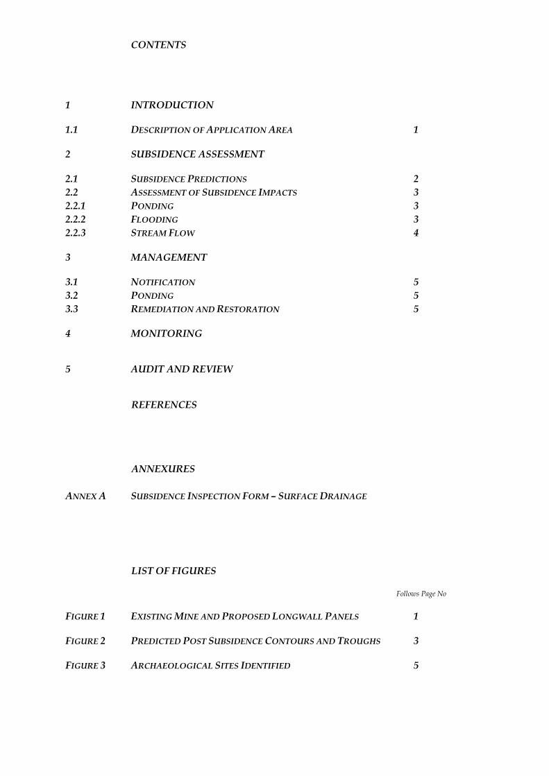
CONTENTS
1 INTRODUCTION
1.1 DESCRIPTION OF APPLICATION AREA 1
2 SUBSIDENCE ASSESSMENT
2.1 SUBSIDENCE PREDICTIONS 2 2.2 ASSESSMENT OF SUBSIDENCE IMPACTS 3 2.2.1 PONDING 3 2.2.2 FLOODING 3 2.2.3 STREAM FLOW 4
3 MANAGEMENT
3.1 NOTIFICATION 5 3.2 PONDING 5 3.3 REMEDIATION AND RESTORATION 5
4 MONITORING
5 AUDIT AND REVIEW
REFERENCES
ANNEXURES
ANNEX A SUBSIDENCE INSPECTION FORM – SURFACE DRAINAGE
LIST OF FIGURES
Follows Page No
FIGURE 1 EXISTING MINE AND PROPOSED LONGWALL PANELS 1
FIGURE 2 PREDICTED POST SUBSIDENCE CONTOURS AND TROUGHS 3
FIGURE 3 ARCHAEOLOGICAL SITES IDENTIFIED 5
ENVIRONMENTAL RESOURCES MANAGEMENT AUSTRALIA 0038321_SURFACE DRAINAGE/FINAL/3 JANUARY 2007
1
1 INTRODUCTION
Environmental Resources Management Australia Pty Ltd (ERM) has been engaged by Glennies Creek Coal Management Pty Ltd (GCCM) to prepare a subsidence management plan for surface drainage within the context of an overall Subsidence Management Plan (SMP) for mining Longwalls 10 to 17 in the Middle Liddell seam. The SMP has been based on a risk assessment and addresses potential subsidence impacts as a result of extracting these longwall blocks.
Longwall Panels 1 to 6 in the Middle Liddell seam have been the subject of s138 approvals under the Coal Mine Regulations Act 1982 and extraction of those panels is complete. GCCM obtained Subsidence Management and s138 approval for Longwall panels 7 to 9 in March and April 2006, respectively.
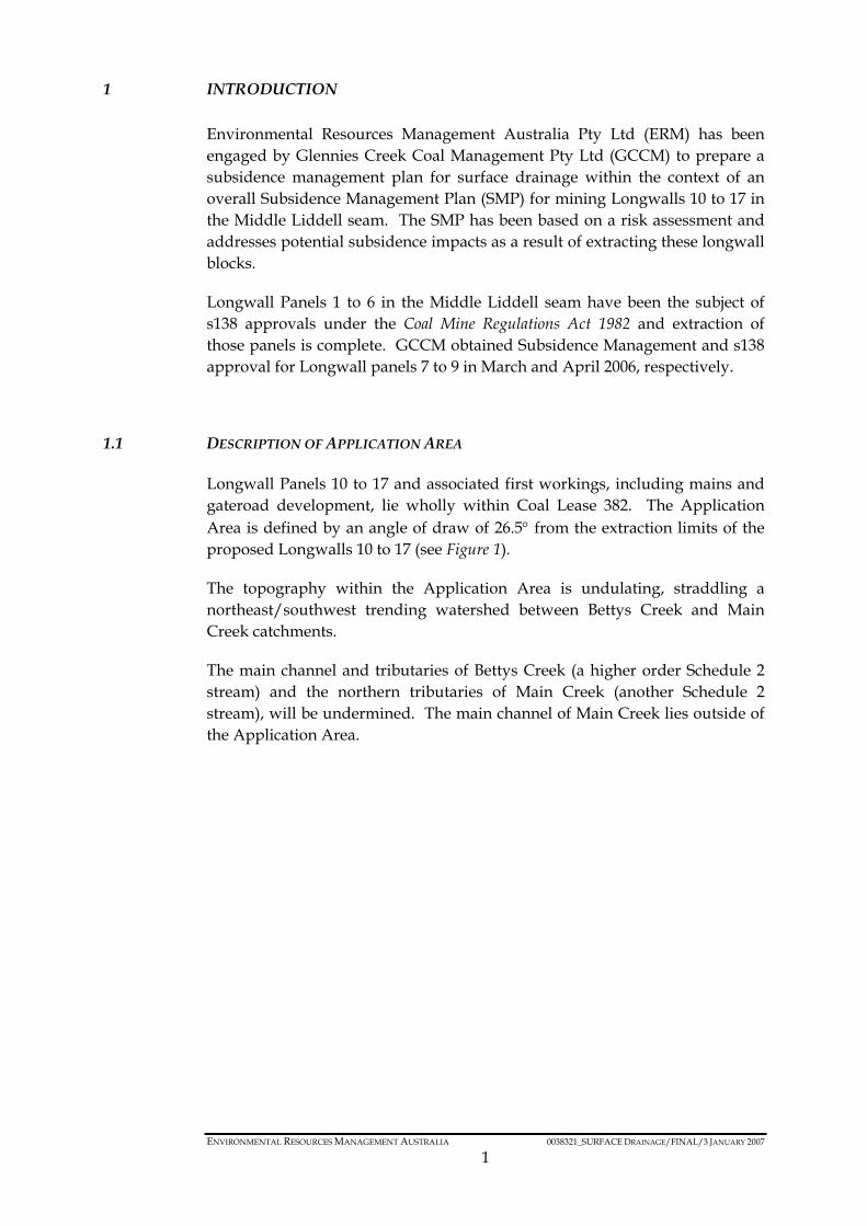
1.1 DESCRIPTION OF APPLICATION AREA
Longwall Panels 10 to 17 and associated first workings, including mains and gateroad development, lie wholly within Coal Lease 382. The Application Area is defined by an angle of draw of 26.5° from the extraction limits of the proposed Longwalls 10 to 17 (see Figure 1).
The topography within the Application Area is undulating, straddling a northeast/southwest trending watershed between Bettys Creek and Main Creek catchments.
The main channel and tributaries of Bettys Creek (a higher order Schedule 2 stream) and the northern tributaries of Main Creek (another Schedule 2 stream), will be undermined. The main channel of Main Creek lies outside of the Application Area.
LW
10
-17
SM
PA
pplic
atio
nA
rea
Legend
Jobs/2
00
/00
-F5
38321
SD
MP
g1
Exis
ting
Min
e&
Pro
posed
Longw
all
Panels
14
11
.cdr
2006
SP
Environm
enta
lR
esourc
es
Managem
entA
ustr
alia
Pty
Ltd
Figure 1
0 2 0m0
Source: Glennies Creek Coal Management
SMP Application Area
Proposed Void as per Application
Mine Workings
Proposed Mine Workings
Existing Mine and Proposed Longwall Panels
Glennies Creek Coal Management Pty Ltd - Glennies CreekSurface Drainage Management Plan
ENVIRONMENTAL RESOURCES MANAGEMENT AUSTRALIA 0038321_SURFACE DRAINAGE/FINAL/3 JANUARY 2007
2
2 SUBSIDENCE ASSESSMENT
A subsidence assessment was carried out for Longwalls 10 to 17 in the Middle Liddell seam by Strata Control Technology (SCT) Pty Ltd (2006). This report is included as Annex F of the SMP Application – Written Report.
A surface and groundwater assessment was carried out by GeoTerra Pty Ltd (2006) with specific reference to subsidence impacts on surface drainage within the Application Area. This report is included as Annex D of the SMP Application – Written Report.
2.1 SUBSIDENCE PREDICTIONS
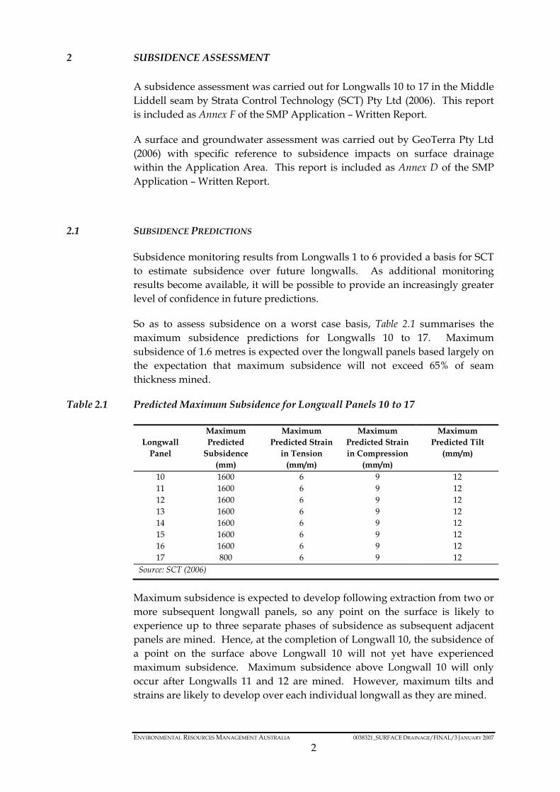
Subsidence monitoring results from Longwalls 1 to 6 provided a basis for SCT to estimate subsidence over future longwalls. As additional monitoring results become available, it will be possible to provide an increasingly greater level of confidence in future predictions.
So as to assess subsidence on a worst case basis, Table 2.1 summarises the maximum subsidence predictions for Longwalls 10 to 17. Maximum subsidence of 1.6 metres is expected over the longwall panels based largely on the expectation that maximum subsidence will not exceed 65% of seam thickness mined.
Table 2.1 Predicted Maximum Subsidence for Longwall Panels 10 to 17
Longwall
Panel
Maximum Predicted
Subsidence (mm)
Maximum Predicted Strain
in Tension (mm/m)
Maximum Predicted Strain in Compression
(mm/m)
Maximum Predicted Tilt
(mm/m)
10 1600 6 9 12 11 1600 6 9 12 12 1600 6 9 12 13 1600 6 9 12 14 1600 6 9 12 15 1600 6 9 12 16 1600 6 9 12 17 800 6 9 12
Source: SCT (2006)
Maximum subsidence is expected to develop following extraction from two or more subsequent longwall panels, so any point on the surface is likely to experience up to three separate phases of subsidence as subsequent adjacent panels are mined. Hence, at the completion of Longwall 10, the subsidence of a point on the surface above Longwall 10 will not yet have experienced maximum subsidence. Maximum subsidence above Longwall 10 will only occur after Longwalls 11 and 12 are mined. However, maximum tilts and strains are likely to develop over each individual longwall as they are mined.
ENVIRONMENTAL RESOURCES MANAGEMENT AUSTRALIA 0038321_SURFACE DRAINAGE/FINAL/3 JANUARY 2007
3
Specific subsidence predictions for small streams and gullies are dependent on their location relative to the longwall panels.
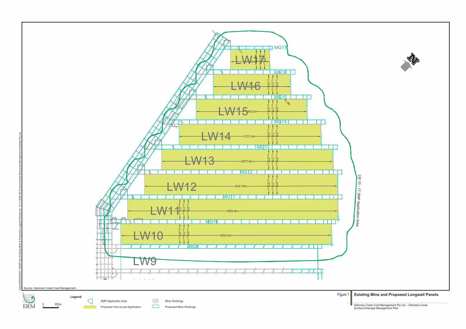
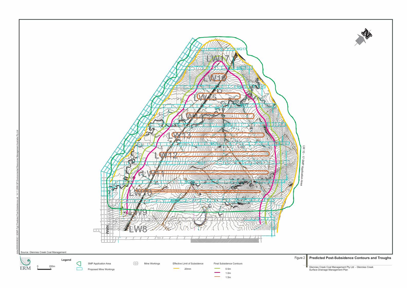
As shown in Figure 2, subsidence troughs of up to 1.6m deep are predicted to develop over Longwalls 10 to 17, with the greatest subsidence occurring over the longwall centres. Remnant ‘highs’ will remain over the chain pillars within the overall subsidence trough , with "highs" of around 0.4m developing over the Longwall Panel 10/11 chain pillar reducing to around 0.1m between Longwall Panels 16 and 17 due to the increased depth of cover (GeoTerra, 2006).
In addition to displaying the predicted subsidence troughs, Figure 2 shows the predicted post-subsidence topographic contours.
2.2 ASSESSMENT OF SUBSIDENCE IMPACTS
2.2.1 Ponding
Temporary or permanent ponding of water in flat lying areas following heavy rain or flooding is a potential effect of vertical subsidence. Temporary ponding may occur in areas of water accumulation due to the progress of the longwall face, and will generally cease to be an issue once the face progresses. Permanent ponding may occur where a depression remains once the longwall face has passed.
An assessment of predicted post-subsidence topographic contours indicates that stream channel ponding is likely to occur within Bettys Creek over Longwall Panels 10 to 15. Due to the relatively flat topography overlying the south western portion of the Application Area, there are areas which are prone to ponding after significant rainfall. Additional obvious post-subsidence ponding is not anticipated in the elevated central and north-eastern sections of the Application Area (GeoTerra 2006).
Ponding of water for an extended time may kill the submerged grasses in the area or result in a change in the vegetation composition.
2.2.2 Flooding
As indicated by GeoTerra (2006), the existing and post-subsidence flood extent does not change upstream of the rail bridge. Downstream of the rail bridge, differential settlement of overbank floodplains causes a reduction in left overbank flows and an increase in right overbank flows and subsequent flood extent. The overbank flows for both existing and post mine subsidence conditions for the 100 year ARI flood is generally less than 0.5m deep.
MG12
MG11
MG8
MG9
MG10
MG13
MG14
MG15
MG16
Legend
Jobs/2
00
/00
-F2
538321
SD
MP
gP
redic
ted
Post-
Subsid
ence
14
1.c
dr
2006
SP
Environm
enta
lR
esourc
es
Managem
entA
ustr
alia
Pty
Ltd
1
Figure 2 Predicted Post-Subsidence Contours and Troughs
0 2 0m0
Source: Glennies Creek Coal Management
SMP Application Area Mine Workings
Proposed Mine Workings
Effective Limit of Subsidence
20mm
Final Subsidence Contours
0.5m
1.0m
1.5m
Glennies Creek Coal Management Pty Ltd - Glennies CreekSurface Drainage Management Plan
LW
10
-17
SM
PA
pplic
atio
nA
rea
ENVIRONMENTAL RESOURCES MANAGEMENT AUSTRALIA 0038321_SURFACE DRAINAGE/FINAL/3 JANUARY 2007
4
This change is unlikely to cause a major channel breakthrough in the short or long term as the 100 year average recurrence interval (ARI) overbank flood velocities are generally less than 0.5m/s.
2.2.3 Stream Flow
GeoTerra (2006) predicts that the estimated level of subsidence will increase channel velocities, shear stress and stream power in Bettys Creek between Cross Section 9 and 11 (see Figure 2 for location) as the creek drains into the subsided area, which may increase channel erosion. Decreased channel velocities, shear stress and stream power occur between the railway line and Cross Section 5 and again between Cross Section 1 and 2 where the main channel drains out of the subsidence area. Increased sedimentation may occur in these areas.
It is noted that the velocities, shear stress and stream power are not overly significant for the 1 Year ARI event for either the existing or subsided condition, and that post-subsidence conditions are also generally similar, indicating that any increased erosion and sedimentation will not be significant (GeoTerra, 2006).
ENVIRONMENTAL RESOURCES MANAGEMENT AUSTRALIA 0038321_SURFACE DRAINAGE/FINAL/3 JANUARY 2007
5
3 MANAGEMENT
Glennies Creek Coal Management (GCCM) is responsible for all costs involved with the monitoring and subsequent remediation/repair works associated with subsidence-related impacts on surface drainage.
GCCM, in consultation with the landowner, will manage any subsidence-related impacts on surface drainage, with the management processes implemented dependent on the level of impact and the actual and potential consequences.
3.1 NOTIFICATION
GCCM will provide landowners with a monthly update of the current location of the longwall face and the estimated progress of the longwall during the following month. This will ensure that landowners are aware of impending potential subsidence impacts on surface drainage within their property.
3.2 PONDING
Should water begin to pond in an area, GCCM will carry out temporary or permanent earthworks to allow the water to drain away. If earthworks are not possible within a short time frame, eg due to legislative requirements or access restrictions, a strategy of pumping water from the ponded area will be assessed by GCCM in consultation with the landowner.
3.3 REMEDIATION AND RESTORATION
GCCM, in consultation with the landowner, will carry out any works that are required to return the surface water drainage system to a similar state as existed prior to subsidence. This may include, but is not limited to, draining ponded areas, re-establishing drainage paths or diverting surface water flows from areas of potential ponding.
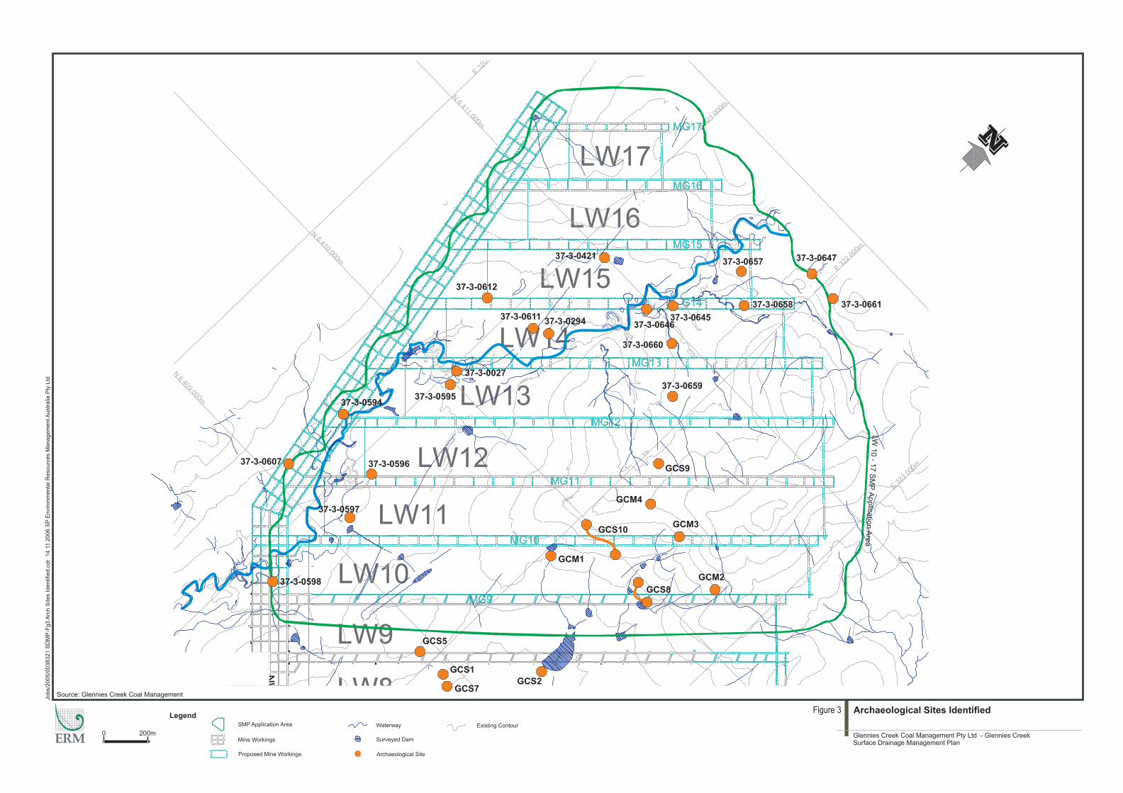
If remedial earthworks are required within an area of an archaeological site, no disturbance will commence prior to the receipt of a Section 90 Permit by the Department of Environment and Conservation (DEC). Any application for a Section 90 Permit will be made in accordance with DEC requirements. Figure 3 shows the location of the sites recorded within the Application Area.
If remedial earthworks are required on protected land as defined under the Rivers and Foreshores Improvement Act, a Section 3A permit will be obtained prior to commencing disturbance.
Legend
0 2 0m0
Source: Glennies Creek Coal Management
SMP Application Area
Mine Workings
Proposed Mine Workings
Waterway
Surveyed Dam
Jobs/2
00
/00
-F3
.cdr
538321
SD
MP
gA
rch
Sites
Identified
2006
SP
Environm
enta
lR
esourc
es
Managem
entA
ustr
alia
Pty
Ltd
14
11
Existing Contour
Figure 3 Archaeological Sites Identified
Glennies Creek Coal Management Pty Ltd - Glennies CreekSurface Drainage Management Plan
Archaeological Site
GCS8
GCS10
GCM1
GCS1
GCS2
GCS5
GCS9
GCS7
37-3-0027
37-3-0294
37-3-0421
37-3-059437-3-0595
37-3-0596
37-3-0597
37-3-0607
37-3-0611
37-3-0612
GCM2
GCM3
GCM4
37-3-0647
37-3-0661
37-3-0598
37-3-0657
37-3-0658
37-3-0645
37-3-0660
37-3-0646
37-3-0659
LW
10
-17
SM
PA
pplic
atio
nA
rea
ENVIRONMENTAL RESOURCES MANAGEMENT AUSTRALIA 0038321_SURFACE DRAINAGE/FINAL/3 JANUARY 2007
6
4 MONITORING
The monitoring of subsidence impacts will comprise three phases and will be based on the landowner providing access:
• pre-mining monitoring to establish a baseline for subsequent monitoring and impact assessment;
• monitoring within the predicted subsidence impact zone during mining to allow the implementation of subsidence impact management processes as required; and
• post-mining monitoring to establish that no further subsidence impacts are likely and to allow the completion of subsidence impact management processes.
As the landowners will have far greater experience and knowledge of surface drainage processes on their land than GCCM, the Company will rely on landowner feedback and advice as to changes in drainage patterns or the presence of new areas of ponding.
Cross-sections across Bettys Creek will be established prior to mining Longwall 10 to allow the measurement of any actual valley closure. The cross-sections will be spaced approximately 100m apart. Each cross-section will consist of survey monuments placed approximately 10m apart, extending a minimum of 20m beyond the defined edge of the creek channel.
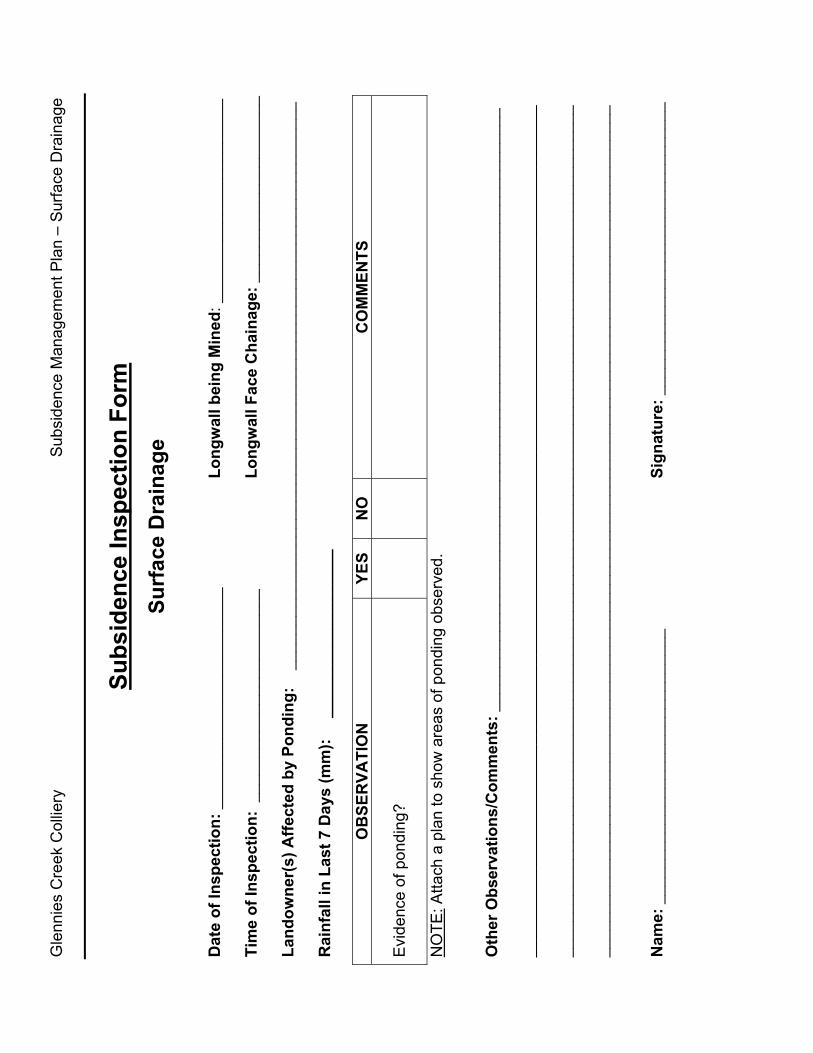
Visual inspections of surface drainage and any ponding through the various phases will be recorded on a Subsidence Inspection Form – Surface Drainage, included as Annex A:
Pre-mining monitoring will comprise:
• an initial study and assessment of the surface water systems;
• an initial survey of Bettys Creek cross-sections to determine a baseline for valley closure;
• documented visual inspections of any ponded areas during and after rain events;
• photographic records of any observed ponding;
• daily rainfall records at the mine site; and
• opportunistic inspections by the landowner.
ENVIRONMENTAL RESOURCES MANAGEMENT AUSTRALIA 0038321_SURFACE DRAINAGE/FINAL/3 JANUARY 2007
7
Monitoring during mining will comprise:
• documented visual inspections of any ponded areas during and after rain events;
• photographic records of any observed ponding;
• daily rainfall records at the mine site; and
• opportunistic inspections by the landowner.
Post-mining monitoring will comprise:
• a survey of Bettys Creek cross sections at the completion of each longwall panel to determine any levels of valley closure;
• documented visual inspections of subsidence impacted areas during and after the first two significant rain events, once the second subsequent longwall panel is complete; and
• photographic records of any detected ponding.
ENVIRONMENTAL RESOURCES MANAGEMENT AUSTRALIA 0038321_SURFACE DRAINAGE/FINAL/3 JANUARY 2007
8
5 AUDIT AND REVIEW
An audit of this management plan will be carried out at the completion of each longwall panel as per Section 11 of the SMP Application – Subsidence Management Plan.
A review of this management plan in terms of monitoring intensity/frequency, management responses and overall practicality will be carried out at the completion of each longwall panel and refinements introduced as appropriate.
ENVIRONMENTAL RESOURCES MANAGEMENT AUSTRALIA 0038321_SURFACE DRAINAGE/FINAL/3 JANUARY 2007
9
REFERENCES
DLWC (2000) Draft Guidelines for Management of Streams in Coal Mining – Hunter Valley. Department of Land and Water Conservation.
GeoTerra (2006) Longwall Panels 10 to 17 Surface Water and Ground Water Assessment, Glennies Creek Colliery NSW. Prepared for Integra Coal Pty Ltd, July 2006.
SCT Pty Ltd (2006) Subsidence Assessment for Longwalls 10 to 17 at Glennies Creek Colliery. Prepared for Glennies Creek Coal Management Pty Ltd, July 2006.
Annex A
Subsidence Inspection Form - Surface Drainage
Gle
nnie
s C
reek
Col
liery
S
ubsi
denc
e M
anag
emen
t Pla
n –
Sur
face
Dra
inag
e
Subs
iden
ce In
spec
tion
Form
Surf
ace
Dra
inag
e D
ate
of In
spec
tion:
___
____
____
____
____
____
__
Long
wal
l bei
ng M
ined
: ___
____
____
____
____
____
Ti
me
of In
spec
tion:
___
____
____
____
____
____
_
Lo
ngw
all F
ace
Cha
inag
e: _
____
____
____
____
____
La
ndow
ner(
s) A
ffect
ed b
y Po
ndin
g:
____
____
____
____
____
____
____
____
____
____
____
____
____
____
____
____
R
ainf
all i
n La
st 7
Day
s (m
m):
____
____
____
____
___
O
BSE
RVA
TIO
N
YES
NO
C
OM
MEN
TS
Evi
denc
e of
pon
ding
?
NO
TE: A
ttach
a p
lan
to s
how
are
as o
f pon
ding
obs
erve
d.
Oth
er O
bser
vatio
ns/C
omm
ents
: ___
____
____
____
____
____
____
____
____
____
____
____
____
____
____
____
____
_ __
____
____
____
____
____
____
____
____
____
____
____
____
____
____
____
____
____
____
____
____
____
____
____
__
____
____
____
____
____
____
____
____
____
____
____
____
____
____
____
____
____
____
____
____
____
____
____
____
__
____
____
____
____
____
____
____
____
____
____
____
____
____
____
____
____
____
____
____
____
____
____
____
__
Nam
e: _
____
____
____
____
____
____
____
__
Sign
atur
e: _
____
____
____
____
____
____
____
____

ERM consulting services worldwide www.erm.com
53 Bonville Ave
Environmental Resources Management Australia
Telephone (02) 4964 2150
Thornton NSW 2322
Facsimile (02) 4964 2152


