48

MEMBERS: A.S.F.E.
American Concrete Institute American Society for Testing and Materials
Florida Institute of Consulting Engineers
SUBSURFACE SOIL EXPLORATION TICE STREET WATER MAIN LOOP FORT MYERS, LEE COUNTY, FLORIDA
Ardaman & Associates, Inc. Geotechnical, Environmental and
Materials Consultants
OFFICES
Orlando, 8008 S. Orange Avenue, Orlando, Florida 32809, Phone (407) 855-3860 Bartow, 1525 Centennial Drive, Bartow, Florida 33830, Phone (863) 533-0858
Cocoa, 1300 N. Cocoa Blvd., Cocoa, Florida 32922, Phone (321) 632-2503 Fort Myers, 9970 Bavaria Road, Fort Myers, Florida 33913, Phone (239) 768-6600
Miami, 2608 W. 84th Street, Hialeah, Florida 33016, Phone (305) 825-2683 Port St. Lucie, 460 Concourse Place NW, Unit 1, Port St. Lucie, Florida 34986, Phone (772) 878-0072
Sarasota, 78 Sarasota Center Blvd., Sarasota, Florida, Phone (941) 922-3526 Tallahassee, 3175 West Tharpe Street, Tallahassee, Florida 32303, Phone (850) 576-6131 Tampa, 3925 Coconut Palm Drive, Suite 115, Tampa, Florida 33619, Phone (813) 620-3389
West Palm Beach, 2200 N. FL Mango Rd., Ste. 101, West Palm Bch., FL 33409, Phone (561)687-8200
Ardaman & Associates, Inc. Geotechnical, Environmental and Materials Consultants
9970 Bavaria Road, Fort Myers, Florida 33913 Phone (239) 768-6600 FAX (239) 768-0409 Florida: Bartow, Fort Myers, Miami, Orlando, Port St. Lucie, Sarasota, Tallahassee, Tampa, West Palm Beach
Louisiana: Alexandria, Baton Rouge, Monroe, New Orleans, Shreveport
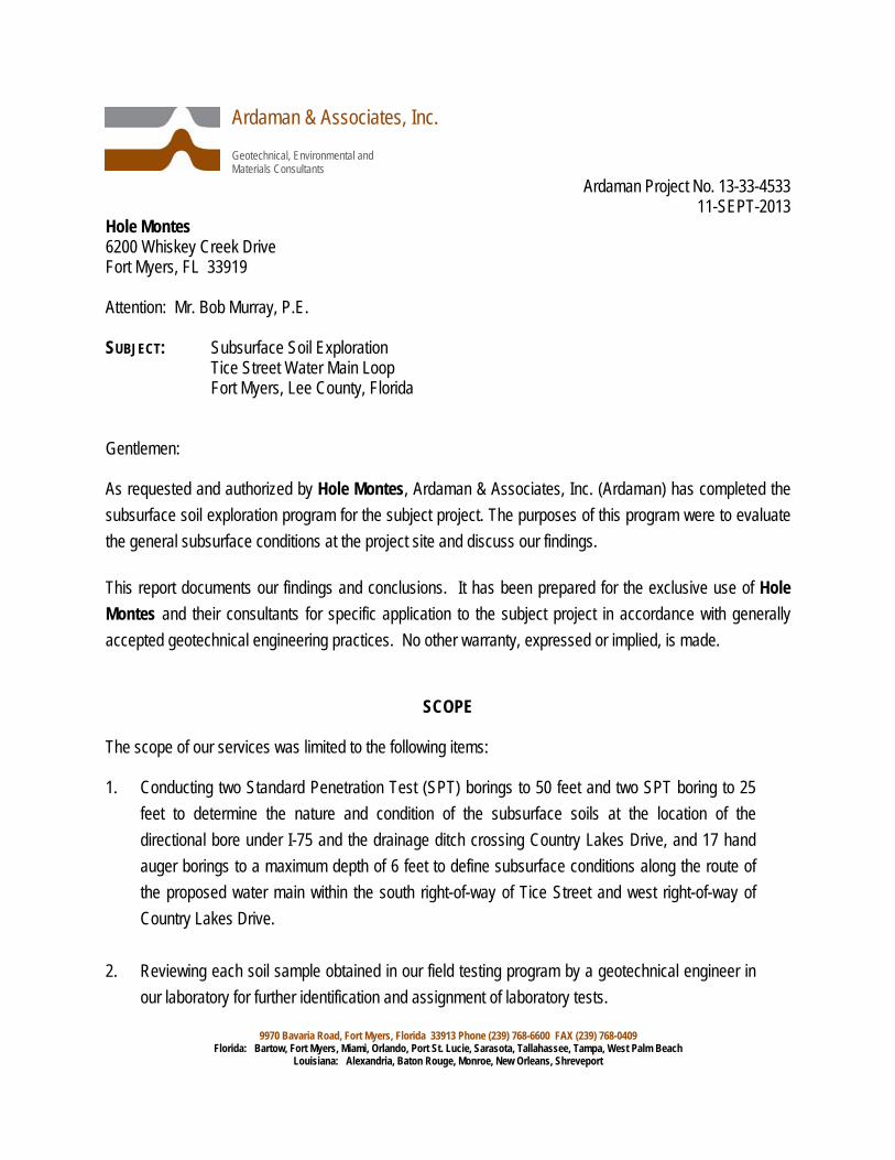
Ardaman Project No. 13-33-4533 11-SEPT-2013 Hole Montes 6200 Whiskey Creek Drive Fort Myers, FL 33919 Attention: Mr. Bob Murray, P.E. SUBJECT: Subsurface Soil Exploration Tice Street Water Main Loop Fort Myers, Lee County, Florida Gentlemen: As requested and authorized by Hole Montes, Ardaman & Associates, Inc. (Ardaman) has completed the subsurface soil exploration program for the subject project. The purposes of this program were to evaluate the general subsurface conditions at the project site and discuss our findings. This report documents our findings and conclusions. It has been prepared for the exclusive use of Hole Montes and their consultants for specific application to the subject project in accordance with generally accepted geotechnical engineering practices. No other warranty, expressed or implied, is made.
SCOPE The scope of our services was limited to the following items: 1. Conducting two Standard Penetration Test (SPT) borings to 50 feet and two SPT boring to 25
feet to determine the nature and condition of the subsurface soils at the location of the directional bore under I-75 and the drainage ditch crossing Country Lakes Drive, and 17 hand auger borings to a maximum depth of 6 feet to define subsurface conditions along the route of the proposed water main within the south right-of-way of Tice Street and west right-of-way of Country Lakes Drive.
2. Reviewing each soil sample obtained in our field testing program by a geotechnical engineer in
our laboratory for further identification and assignment of laboratory tests.

Report of Subsurface Soil Exploration for 11-SEPT-2013 Tice Street Water Main Loop Project No.13-33-4533 Fort Myers, Lee Co., FL Page No. 2
Ardaman & Associates, Inc.
3. Performing the appropriate laboratory tests on selected samples. 4. Analyzing the existing soil conditions with respect to the proposed construction. 5. Preparing this report to document the results of our field exploration and laboratory testing
programs.
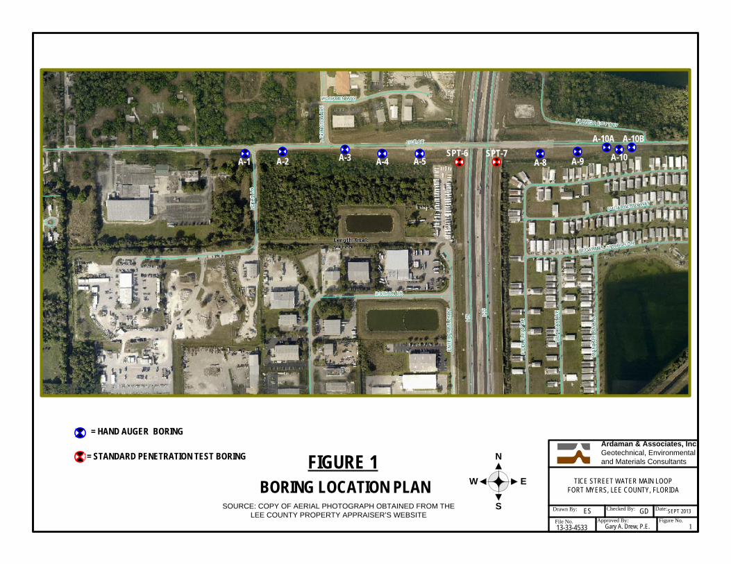
SITE LOCATION AND PROJECT DESCRIPTION The Tice Street Water Main Loop project limits are from the Tice Street and Detar Way intersection eastward along the south right-of-way of Tice Street to Country Lakes Drive, then southward along the west right-of-way of Country Lakes Drive to Longleaf Drive. New 12-inch ductile iron pipe (D.I.P.) water main is proposed along Tice Street, and 10-inch D.I.P. water main along Country Lakes Drive. Under I-75, 14-inch HDPE pipe within 24-inch HDPE casing will be installed by directional bore. Under the Country Lakes Drive drainage ditch, 12-inch HDPE pipe will be installed. Aerial photographs of the water main alignments with boring locations are presented as Figures 1 and 1A in Appendix 1.
REVIEW OF SOIL SURVEY MAPS
The United States Department of Agriculture Natural Resources Conservation Services Soil Survey of Lee County, Florida (1984) was reviewed for major shallow soil types within the project limits. The Soil Survey identified four major soil map units described as follows:
Wabasso sand, limestone substratum (42). This soil map unit occurs within the Tice Street right-of-way from the project beginning near Detar Way to about 500 feet eastward. This soil type is described as fine sand (SP, SP-SM) and silty fine sand (SM) to a depth of 3 feet underlain by silty clayey sand (SM, SC-SM, SC). Weathered bedrock is at a depth of 4 feet. Oldsmar sand (33). This soil map unit occurs in the Tice Street right-of-way from about Lexington Avenue to the start of the I-75 east bridge approach embankment. This soil type is described as fine sand (SP-SP-SM) and slightly silty fine sand (SM) to a depth of 4 feet underlain by silty clayey sand (SM, SC-SM, SC) to 5 feet. Slightly silty fine sand (SP-SM, SM) is encountered again below 5 feet.

Report of Subsurface Soil Exploration for 11-SEPT-2013 Tice Street Water Main Loop Project No.13-33-4533 Fort Myers, Lee Co., FL Page No. 3
Ardaman & Associates, Inc.
Hallandale fine sand (6). This soil map unit occurs within the Tice Street right-of-way from the start of the I-75 east bridge approach embankment to Country Lakes Drive. This soil is described as fine sand (SP, SP-SM) to a depth of 12 inches underlain by soft weathered limestone bedrock that has solution holes extending to a depth of 25 inches. Boca fine sand (13). This soil map unit occurs within the Country Lakes Drive right-of-way from Tice Street to the project end at Longleaf Drive. This soil is described as fine sands (SP, SP-SM) to a depth of about 2 feet underlain by 0.5 feet of clayey sand (SC). At a depth of 2.5 feet is a layer of soft fractured limestone.
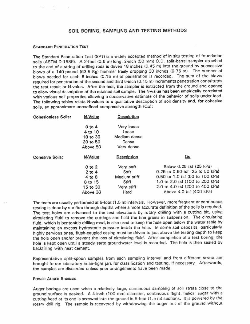
FIELD EXPLORATION PROGRAM Our field exploration consisted of performing two Standard Penetration Test (SPT) borings labeled SPT-5 and 6 at the directional bore location under I-75, two SPT boring labeled SPT-15 and 16 and 17 hand auger borings labeled A-1 through A-5, A-7 through A-14 and A-16 through A19 on approximately 300-foot centers along the proposed water main routes. The SPT borings located within the I-75 right-of-way were drilled to a depth of 50 feet below the existing ground surface, and the SPT borings for the drainage ditch crossing on Country Lakes Drive were drilled to 25 feet. The SPT borings were conducted using methods consistent with ASTM D-1586. A hand-held bucket auger was used to advance each hand auger boring to a depth of 6 feet unless refusal on rock was encountered. The equipment and procedures used in the SPT and hand auger borings are described in detail in Appendix 3. The approximate locations of the four SPT borings and 17 hand auger borings are shown on the Boring Location Plan presented as Figures 1 and 1A included in Appendix 1. The GPS coordinates of each boring are shown on each boring log.
GENERAL SUBSURFACE CONDITIONS The general subsurface conditions encountered during the field exploration are shown on the attached soil boring logs in Appendix I. Soil stratification is based on examination of recovered soil samples and

Report of Subsurface Soil Exploration for 11-SEPT-2013 Tice Street Water Main Loop Project No.13-33-4533 Fort Myers, Lee Co., FL Page No. 4
Ardaman & Associates, Inc.
interpretation of the field boring logs. The stratification lines represent the approximate boundaries between the soil types, the actual transitions may be gradual. The two SPT borings SPT-6 and 7 at the directional bore under I-75 disclosed similar subsurface conditions described as follows. Depth From To Soil Description Ground Surface 22' Loose to medium dense fine sands (SP) and slightly silty fine sands (SP- SM) with trace amounts of shell fragments. 22' 27' Soft calcareous very clayey fine sands (SC). 27' 42' Medium dense to dense fine sands (SP) and slightly silty fine sands (SP- SM) with shell fragments. 42' (50') TERM Medium stiff clayey sands (SC) and sandy clays (CL) with medium plasticity. The two SPT borings SPT-15 and 16 for the crossing under the Country Lakes Drive drainage ditch also disclosed similar subsurface conditions described as follows. Depth From To Soil Description Ground Surface 4' Loose to medium dense fine sands (SP). 4' 5' Medium stiff clayey sand. (SC). 5' 13' Loose fine sands (SP) with trace amounts of shell fragments. 13' 23' Loose calcareous slightly silty fine sands (SM) with trace amounts of gravel-size shell and limerock fragments. 23' (25') TERM Loose silty clayey sands (SC-SM), with trace to some amounts of gravel- size shell and limerock fragments.
Report of Subsurface Soil Exploration for 11-SEPT-2013 Tice Street Water Main Loop Project No.13-33-4533 Fort Myers, Lee Co., FL Page No. 5
Ardaman & Associates, Inc.
The 17 hand auger borings encountered mostly fine sands (SP) from the ground surface to the 6-foot depth explored. Occasionally a thin stratum of silty clayey sand (SC-SM or A-2-6) or clayey sand (SC or A-2-4) was encountered in the 3-1/2 to 4-1/2 foot depth range. The hand auger borings along Country Lakes Road encountered a gravelly fine sand (SP or A-3) below a depth of about 4 feet with the gravel composed of shell and limerock fragments. It is possible that cobble and boulder-size pieces of limerock and cemented sands occur within this stratum. No rock was encountered in the borings except in boring A-10 where refusal was encountered at a depth of 2.5 feet. Additional auger borings A-10A and 10B were drilled 50 feet west and east, respectively, to determine the extent of the rock. Boring A-10A did not encounter rock within the 6-foot depth explored. Boring A-10B encountered rock at a depth of 1-foot. This indicates that shallow caprock should be expected within this segment. Groundwater was encountered within 1-foot of the ground surface in the auger borings performed along Tice Street on the date of drilling (9/4/13). Along Country Lakes Drive, groundwater was typically encountered in the 3 to 3.5-foot depth range on the date of drilling (8/29/13). The groundwater depths shown on the boring logs represent the ground water surface encountered on the dates shown. Fluctuations in groundwater level should be anticipated throughout the year due to seasonal variations in rainfall, and other factors.
LABORATORY TESTING PROGRAM Representative soil samples obtained during our field sampling operation were packaged and transferred to our office and, thereafter, examined by a geotechnical engineer to obtain more accurate descriptions of the existing soil strata. Laboratory testing was performed on selected samples as deemed necessary to aid in soil classification and to further define the engineering properties of the soils. The laboratory tests included Natural Moisture Content, Percent Finer that the U.S. No. 200 Sieve (percent silt and clay) and Sieve Analysis. The test results are presented on the attached soil boring logs at the depths from which the samples were recovered. The boring logs are included in Appendix 1 of this report. The results of sieve analysis are presented on grain-size distribution sheets included in Appendix 2. The soil descriptions shown on the logs

Report of Subsurface Soil Exploration for 11-SEPT-2013 Tice Street Water Main Loop Project No.13-33-4533 Fort Myers, Lee Co., FL Page No. 6
Ardaman & Associates, Inc.
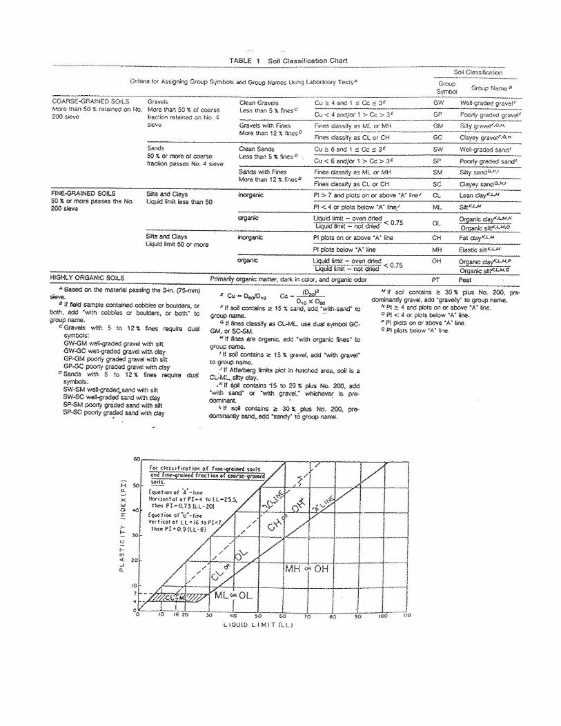
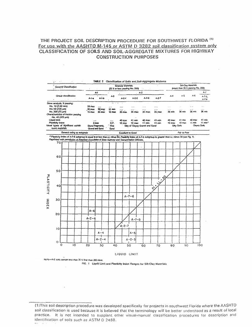
are based upon visual-manual procedures in accordance with local practice. Soil classification is in general accordance with the Unified Soil Classification System (ASTM D-2487) and is also based on visual-manual procedures. The soils recovered from the borings were also classified in accordance with AASHTO M-145–Recommended Procedure for the Classification of Soils and Soil-Aggregate Mixtures for Highway Construction Purposes.
DISCUSSION
The hand auger borings encountered mostly fine sands (SP or A-3) occasionally underlain by thin layers of silty clayey sands (SC-SM or A-2-4) and clayey sands (SC or A-2-6) from the ground surface to the 6-foot depth explored. Only auger borings A-10 and A-10B terminated on rock at depths of 2.5 feet and 1-foot, respectively. The Soil Survey indicates that weathered bedrock occurs at a depth of 4 feet within the Wabasso sand, limestone substratum (42) soil map unit identified at the project beginning near Detar Way. The soil survey also indicates that soft weathered limestone bedrock occurs at a depth of 12 inches within the Hallandale fine sand (6) soil map unit identified along Tice Street east of the I-75 bridge. It also indicates that soft fractured limestone occurs at a depth of 2.5 feet within the Boca fine sand (13) soil map unit identified along Country Lakes Drive. Based upon the auger borings, limestone rock should be expected along some segments of Tice Street east of I-75 bridge. Also, cobble and boulder-size pieces of limerock and cemented soils may occur within the gravelly sand stratum encountered below a depth of 4 feet in the auger borings along Country Lakes Drive. Typically, heavy excavators can remove soft limestone and boulders; however, dynamic methods using hydraulic hammers or hoes will be needed to remove hard limestone or large boulders where they occur. Use of excavated rock as a fill material will require further processing (crushing and screening) to reduce particle size to mostly sand and gravel size. The fine sands (SP or A-3 soils) encountered in the test borings are suitable for use as backfill materials and suitable for pipe bedding. However, the pipe should be bedded in gravel such as FDOT No. 89 or 57 Stone if rock occurs within 6 inches of the pipe bottom, or unsuitable soil types are encountered at pipe invert such as silty clayey sands (SC-SM or A-2-4) or clayey sands (SC or A-2-6).
Report of SubTice Street WFort Myers, L
Ar
While therespectiveanticipatedand visuallogs is adesignated If you hav Very truly ARDAMAFlorida C
Gary A. DVice PresiGAD/egs Distribution: Client –
bsurface Soil ExplWater Main Loop Lee Co., FL
rdaman & Assoc
borings are e vertical reacd and may bel examination pproximate ad boring locat
ve any questio
yours,
AN & ASSOCIertificate of A
rew, P.E. ident/Branch M
– 2 hard copies +
loration for
iates, Inc.
representativches, local v
e encountered of selected saand the descions and on th
ons about this
IATES, INC. Authorization
Manager
+ electronic pdf
GENER
ve of subsurfvariations chad. The boring ample in the lacription represhe particular d
report, pleas
n No. 000059
RAL COMMEN
face conditionracteristic of logs and relaaboratory. Thsents our intdate drilled.
e contact this
950
NTS
ns at their rethe subsurfa
ated informatioe delineation terpretation o
s office.
espective locaace materials on are based between soil tof subsurface
11-SEPProject No.13-3
Pag
ations and for of the regio on the driller'types shown o conditions a
PT-2013 33-4533 ge No. 7
r their on are s logs on the at the
Ardaman & Associates, Inc.
APPENDIX 1 • FIGURE 1 AND 1A – BORING LOCATION PLANS • SPT AND HAND AUGER BORING LOGS
Ardaman & Associates, Inc.Geotechnical, Environmental and Materials ConsultantsN
S
EWBORING LOCATION PLANDrawn By: Checked By: Date:
File No. Approved By: Figure No.GD
13-33-4533
TICE STREET WATER MAIN LOOPFORT MYERS, LEE COUNTY, FLORIDA
ES SEPT 2013
1Gary A. Drew, P.E.
FIGURE 1
SOURCE: COPY OF AERIAL PHOTOGRAPH OBTAINED FROM THE LEE COUNTY PROPERTY APPRAISER’S WEBSITE
= STANDARD PENETRATION TEST BORING
SPT-6A-1 A-2 A-3 A-4 A-5
SPT-7A-8 A-9
= HAND AUGER BORING
A-10
A-10A A-10B

Ardaman & Associates, Inc.Geotechnical, Environmental and Materials ConsultantsN
S
EWBORING LOCATION PLANDrawn By: Checked By: Date:
File No. Approved By: Figure No.GD
13-33-4533
TICE STREET WATER MAIN LOOPFORT MYERS, LEE COUNTY, FLORIDA
ES SEPT 2013
1AGary A. Drew, P.E.
FIGURE 1A
SOURCE: COPY OF AERIAL PHOTOGRAPH OBTAINED FROM THE LEE COUNTY PROPERTY APPRAISER’S WEBSITE
= STANDARD PENETRATION TEST BORING
= HAND AUGER BORING
A-8SPT-7A-9
A-10 A-11 A-12
A-13
A-14
A-17
A-18
A-19
SPT-15
SPT-16
A-10BA-10A
0
1
2
3
4
5
6
7
1
2
3
SP
SP
Poorly Graded Sand - Brown to light gray fine sand. (A-3)
Poorly Graded Sand - Dark brown slightly organic finesand. (A-3)
AUGER BORING TERMINATED AT 6.0'
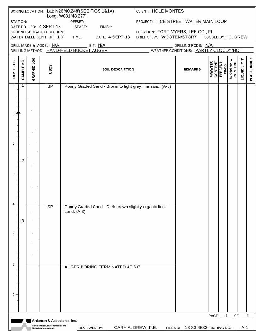
BORING LOCATION: Lat: N26 40.248'(SEE FIGS.1&1A)Long: W081 48.277'
CLIENT: HOLE MONTES
STATION: OFFSET: PROJECT: TICE STREET WATER MAIN LOOPDATE DRILLED: 4-SEPT-13 START: FINISH:GROUND SURFACE ELEVATION: LOCATION: FORT MYERS, LEE CO., FLWATER TABLE DEPTH (ft): 1.0' TIME: DATE: 4-SEPT-13 DRILL CREW: WOOTEN/STORY LOGGED BY: G. DREW
DRILL MAKE & MODEL: N/A BIT: N/A DRILLING RODS: N/ADRILLING METHOD: HAND-HELD BUCKET AUGER WEATHER CONDITIONS: PARTLY CLOUDY/HOT
PAGE 1 OF
REVIEWED BY: GARY A. DREW, P.E. FILE NO: 13-33-4533 BORING NO.: A-1
DEP
TH
, FT
.
SA
MPL
E N
O.
GRA
PHIC
LO
G
USC
S
SOIL DESCRIPTION REMARKS
%W
ATER
CO
NTEN
TPE
RC
ENT
FIN
ES
% O
RG
AN
ICC
ON
TEN
T
LIQ
UID
LIM
IT
PLA
ST. IN
DEX
1
0
1
2
3
4
5
6
7
1
2
3
SP
SP
Poorly Graded Sand - Brown to gray fine sand. (A-3)
Poorly Graded Sand - Dark brown slightly organic finesand. (A-3)
AUGER BORING TERMINATED AT 6.0'
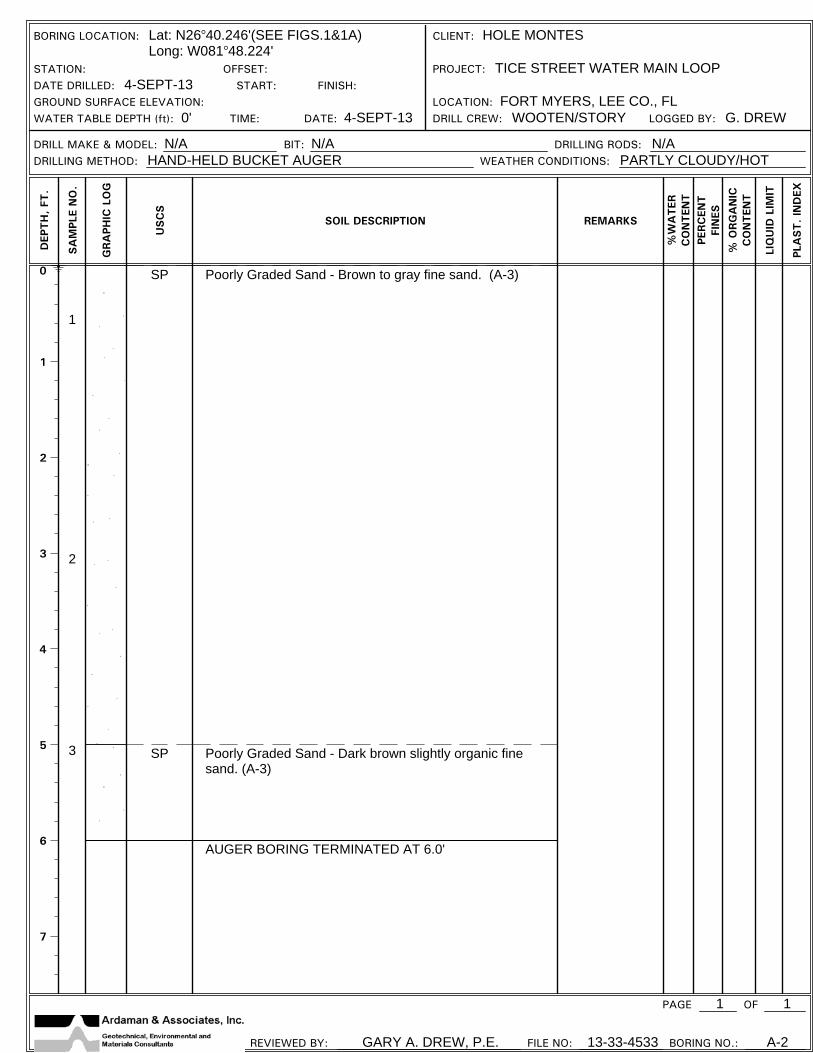
BORING LOCATION: Lat: N26 40.246'(SEE FIGS.1&1A)Long: W081 48.224'
CLIENT: HOLE MONTES
STATION: OFFSET: PROJECT: TICE STREET WATER MAIN LOOPDATE DRILLED: 4-SEPT-13 START: FINISH:GROUND SURFACE ELEVATION: LOCATION: FORT MYERS, LEE CO., FLWATER TABLE DEPTH (ft): 0' TIME: DATE: 4-SEPT-13 DRILL CREW: WOOTEN/STORY LOGGED BY: G. DREW
DRILL MAKE & MODEL: N/A BIT: N/A DRILLING RODS: N/ADRILLING METHOD: HAND-HELD BUCKET AUGER WEATHER CONDITIONS: PARTLY CLOUDY/HOT
PAGE 1 OF
REVIEWED BY: GARY A. DREW, P.E. FILE NO: 13-33-4533 BORING NO.: A-2
DEP
TH
, FT
.
SA
MPL
E N
O.
GRA
PHIC
LO
G
USC
S
SOIL DESCRIPTION REMARKS
%W
ATER
CO
NTEN
TPE
RC
ENT
FIN
ES
% O
RG
AN
ICC
ON
TEN
T
LIQ
UID
LIM
IT
PLA
ST. IN
DEX
1
0
1
2
3
4
5
6
7
1
2
3
SP
SP
SP
Poorly Graded Sand - Brown fine sand. (A-3)
Poorly Graded Sand with Gravel - Light gray fine sand,some gravel-size shell and limerock fragments. (A-3)
Poorly Graded Sand - Brown fine sand. (A-3)
AUGER BORING TERMINATED AT 6.0'
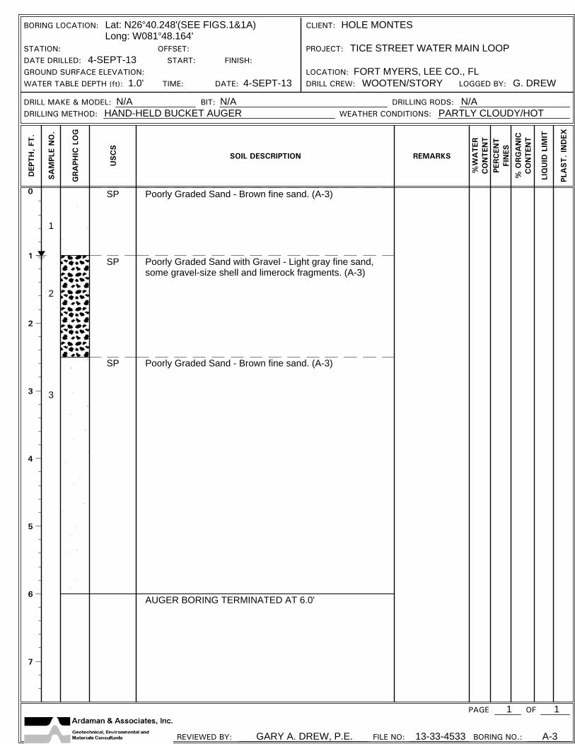
BORING LOCATION: Lat: N26 40.248'(SEE FIGS.1&1A)Long: W081 48.164'
CLIENT: HOLE MONTES
STATION: OFFSET: PROJECT: TICE STREET WATER MAIN LOOPDATE DRILLED: 4-SEPT-13 START: FINISH:GROUND SURFACE ELEVATION: LOCATION: FORT MYERS, LEE CO., FLWATER TABLE DEPTH (ft): 1.0' TIME: DATE: 4-SEPT-13 DRILL CREW: WOOTEN/STORY LOGGED BY: G. DREW
DRILL MAKE & MODEL: N/A BIT: N/A DRILLING RODS: N/ADRILLING METHOD: HAND-HELD BUCKET AUGER WEATHER CONDITIONS: PARTLY CLOUDY/HOT
PAGE 1 OF
REVIEWED BY: GARY A. DREW, P.E. FILE NO: 13-33-4533 BORING NO.: A-3
DEP
TH
, FT
.
SA
MPL
E N
O.
GRA
PHIC
LO
G
USC
S
SOIL DESCRIPTION REMARKS
%W
ATER
CO
NTEN
TPE
RC
ENT
FIN
ES
% O
RG
AN
ICC
ON
TEN
T
LIQ
UID
LIM
IT
PLA
ST. IN
DEX
1
0
1
2
3
4
5
6
7
1
2
3
SP Poorly Graded Sand - Brown to gray fine sand. (A-3)
AUGER BORNG TERMINATED AT 4.5'
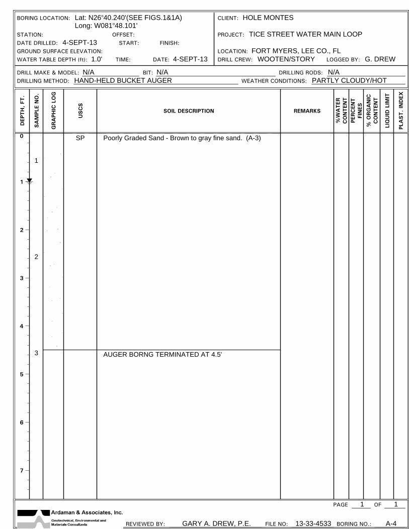
BORING LOCATION: Lat: N26 40.240'(SEE FIGS.1&1A)Long: W081 48.101'
CLIENT: HOLE MONTES
STATION: OFFSET: PROJECT: TICE STREET WATER MAIN LOOPDATE DRILLED: 4-SEPT-13 START: FINISH:GROUND SURFACE ELEVATION: LOCATION: FORT MYERS, LEE CO., FLWATER TABLE DEPTH (ft): 1.0' TIME: DATE: 4-SEPT-13 DRILL CREW: WOOTEN/STORY LOGGED BY: G. DREW
DRILL MAKE & MODEL: N/A BIT: N/A DRILLING RODS: N/ADRILLING METHOD: HAND-HELD BUCKET AUGER WEATHER CONDITIONS: PARTLY CLOUDY/HOT
PAGE 1 OF
REVIEWED BY: GARY A. DREW, P.E. FILE NO: 13-33-4533 BORING NO.: A-4
DEP
TH
, FT
.
SA
MPL
E N
O.
GRA
PHIC
LO
G
USC
S
SOIL DESCRIPTION REMARKS
%W
ATER
CO
NTEN
TPE
RC
ENT
FIN
ES
% O
RG
AN
ICC
ON
TEN
T
LIQ
UID
LIM
IT
PLA
ST. IN
DEX
1

0
1
2
3
4
5
6
7
1
2
3
SP Poorly Graded Sand - Brown to gray fine sand. (A-3)
AUGER BORING TERMINATED AT 6.0'
BORING LOCATION: Lat: N26 40.236'(SEE FIGS.1&1A)Long: W081 48.059'
CLIENT: HOLE MONTES
STATION: OFFSET: PROJECT: TICE STREET WATER MAIN LOOPDATE DRILLED: 4-SEPT-13 START: FINISH:GROUND SURFACE ELEVATION: LOCATION: FORT MYERS, LEE CO., FLWATER TABLE DEPTH (ft): 1.0' TIME: DATE: 4-SEPT-13 DRILL CREW: WOOTEN/STORY LOGGED BY: G. DREW
DRILL MAKE & MODEL: N/A BIT: N/A DRILLING RODS: N/ADRILLING METHOD: HAND-HELD BUCKET AUGER WEATHER CONDITIONS: PARTLY CLOUDY/HOT
PAGE 1 OF
REVIEWED BY: GARY A. DREW, P.E. FILE NO: 13-33-4533 BORING NO.: A-5
DEP
TH
, FT
.
SA
MPL
E N
O.
GRA
PHIC
LO
G
USC
S
SOIL DESCRIPTION REMARKS
%W
ATER
CO
NTEN
TPE
RC
ENT
FIN
ES
% O
RG
AN
ICC
ON
TEN
T
LIQ
UID
LIM
IT
PLA
ST. IN
DEX
1

0
5
10
15
20
25
30
35
4- 5- 5
4- 5- 3
3- 3- 3
2- 3- 2
5- 6- 9
4- 2- 2
2- 1- 1
4- 6- 5
5- 6- 6
10
8
6
5
15
4
2
11
12
1
2
3
4
5
6
7
8
9
SP
SP
SP-SM
SC
SP-SM
SP
Poorly Graded Sand - Brown fine sand.(A- 3)
Poorly Graded Sand - Gray fine sand, trace tosome shell fragments. (A-3)
Poorly Graded Sand with Silt - Gray slightly siltyfine sand, trace shell fragments. (A-2-4)
Clayey Sand - Gray calcareous very clayey finesand, trace shell fragments. (A-6)
Poorly Graded Sand with Silt - Gray slightly siltyfine sand, trace shell fragments. (A-2-4)
Poorly Graded Sand - Gray fine sand, trace to
Hand Augered to 4.5'
5' of casing installed.
Safety hammer used 4.5to 14'
Auto hammer 14' toTERM.
BORING LOCATION: SEE FIG. 1 AND 1A BORING LOCATION PLAN CLIENT: HOLE MONTESSTATION: N26 40.239' OFFSET: W081 48.001' PROJECT: TICE STREET WATER MAIN LOOPDATE DRILLED: 05-SEP-13 START: FINISH:GROUND SURFACE ELEVATION: TIME: LOCATION: FORT MYERS, LEE CO., FLORIDAWATER TABLE DEPTH (ft): 5.5' DATE: 05-SEP-13 DRILL CREW: WOOTEN/STORY LOGGED BY: G. DREW
DRILL MAKE & MODEL: CME-55 BIT: 3-7/8" DIA. TRICONE ROLLER DRILLING RODS: NWDRILLING METHOD: ROTARY WASH WITH DRILLING FLUID WEATHER CONDITIONS: PARTLY CLOUDY/HOT
PAGE 1 OF
REVIEWED BY: GARY A. DREW, P.E. FILE NO: 13-33-4533 BORING NO.: SPT-6
DEP
TH
, FT
.
BLOWS
SPT
N-V
ALU
E
SA
MPL
E N
O.
GRA
PHIC
LO
G
USC
S
SOIL DESCRIPTION REMARKS
% W
ATER
CO
NTEN
T
PERC
ENT
FIN
ES
% O
RG
AN
ICC
ON
TEN
T
LIQ
UID
LIM
IT
PLA
ST. IN
DEX
2

40
45
50
55
60
65
70
75
80
11- 9- 12
7- 9- 5
1- 1- 1
21
14
2
10
11
12
SC
CL
some shell fragments. (A-3)
Clayey Sand - Green clayey fine sand. (A-2-6)
Sandy Lean Clay - Green sandy clay, mediumplasticity. (A-7-6)
SPT BORING TERMINATED AT 50.5'
PAGE 2 OF
REVIEWED BY: GARY A. DREW, P.E. FILE NO: 13-33-4533 BORING NO.: SPT-6
DEP
TH
, FT
.
BLOWS
SPT
N-V
ALU
E
SA
MPL
E N
O.
GRA
PHIC
LO
G
USC
S
SOIL DESCRIPTION REMARKS
% W
ATER
CO
NTEN
T
PERC
ENT
FIN
ES
% O
RG
AN
ICC
ON
TEN
T
LIQ
UID
LIM
IT
PLA
ST. IN
DEX
2

0
5
10
15
20
25
30
35
10- 12- 13
6- 8- 8
5- 5- 4
3- 3- 3
7- 5- 4
3- 2- 2
1- 1- 1
7- 16- 22
6- 8- 11
25
16
9
6
9
4
2
38
19
1
2
3
4
5
6
7
8
9
SP
SP-SM
SP
SP-SM
SC
SP
SP-SM
Poorly Graded Sand - Gray to brown fine sand.(A-3)
Poorly Graded Sand with Silt - Slightly silty finesand. (A-2-4)
Poorly Graded Sand - Brown fine sand, trace tosome shell fragments. (A-3)
Poorly Graded Sand with Silt - Gray slightly siltyfine sand, trace shell fragments. (A-2-4)
Clayey Sand - Gray calcareous very clayey finesand, trace shell fragments. (A-6)
Poorly Graded Sand - Gray fine sand, trace tosome shell fragments. (A-3)
Poorly Graded Sand with Silt - Gray slightly silty
Hand Augered to 4.5'
5' of casing installed.
Safety hammer used 4.5to 14'
Auto hammer 14' toTERM.
BORING LOCATION: SEE FIG. 1 AND 1A BORING LOCATION PLAN CLIENT: HOLE MONTESSTATION: N26 40.223' OFFSET: W081 47.960' PROJECT: TICE STREET WATER MAIN LOOPDATE DRILLED: 05-SEP-13 START: FINISH:GROUND SURFACE ELEVATION: TIME: LOCATION: FORT MYERS, LEE CO., FLORIDAWATER TABLE DEPTH (ft): 4.0' DATE: 05-SEP-13 DRILL CREW: WOOTEN/STORY LOGGED BY: G. DREW
DRILL MAKE & MODEL: CME-55 BIT: 3-7/8" DIA. TRICONE ROLLER DRILLING RODS: NWDRILLING METHOD: ROTARY WASH WITH DRILLING FLUID WEATHER CONDITIONS: PARTLY CLOUDY/HOT
PAGE 1 OF
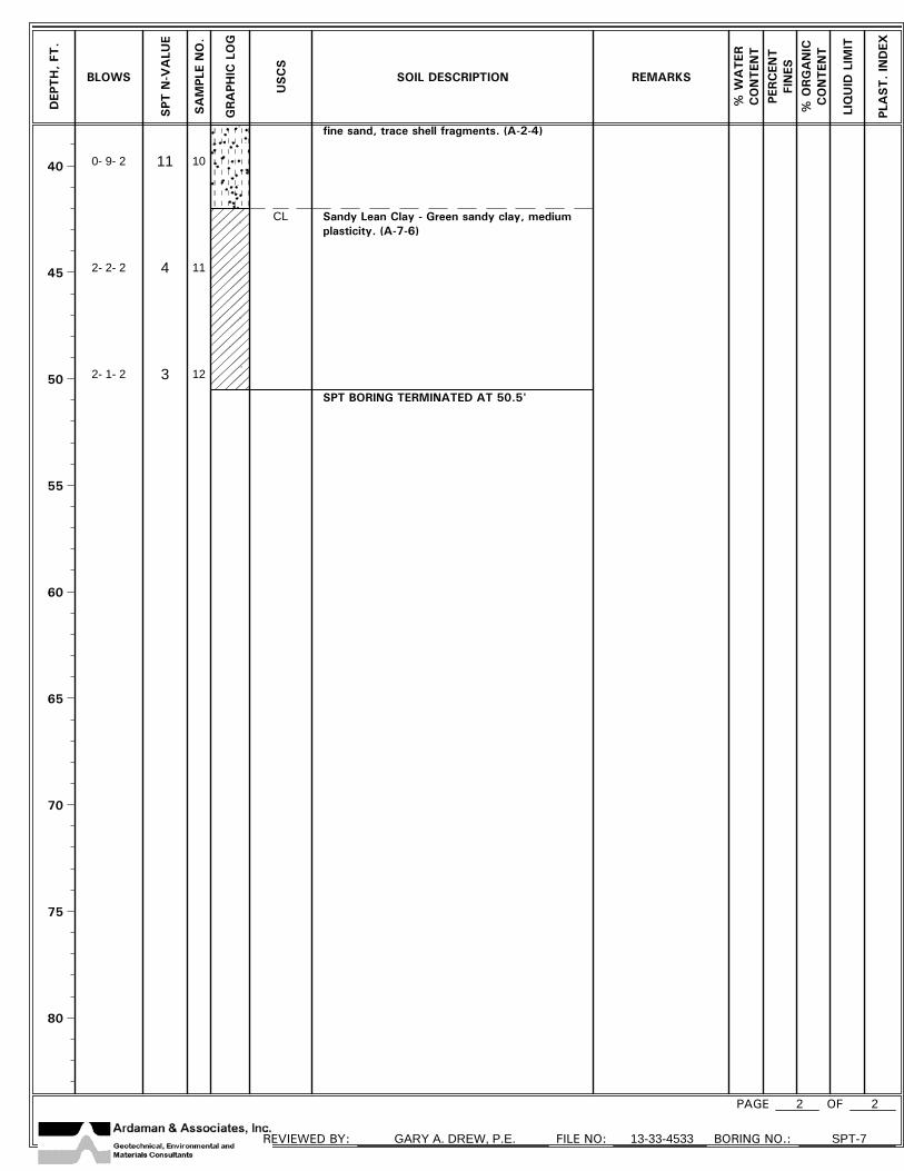
REVIEWED BY: GARY A. DREW, P.E. FILE NO: 13-33-4533 BORING NO.: SPT-7
DEP
TH
, FT
.
BLOWS
SPT
N-V
ALU
E
SA
MPL
E N
O.
GRA
PHIC
LO
G
USC
S
SOIL DESCRIPTION REMARKS
% W
ATER
CO
NTEN
T
PERC
ENT
FIN
ES
% O
RG
AN
ICC
ON
TEN
T
LIQ
UID
LIM
IT
PLA
ST. IN
DEX
2
40
45
50
55
60
65
70
75
80
0- 9- 2
2- 2- 2
2- 1- 2
11
4
3
10
11
12
CL
fine sand, trace shell fragments. (A-2-4)
Sandy Lean Clay - Green sandy clay, mediumplasticity. (A-7-6)
SPT BORING TERMINATED AT 50.5'
PAGE 2 OF
REVIEWED BY: GARY A. DREW, P.E. FILE NO: 13-33-4533 BORING NO.: SPT-7
DEP
TH
, FT
.
BLOWS
SPT
N-V
ALU
E
SA
MPL
E N
O.
GRA
PHIC
LO
G
USC
S
SOIL DESCRIPTION REMARKS
% W
ATER
CO
NTEN
T
PERC
ENT
FIN
ES
% O
RG
AN
ICC
ON
TEN
T
LIQ
UID
LIM
IT
PLA
ST. IN
DEX
2

0
1
2
3
4
5
6
7
1
2
3
SP
SP-SM
SC-SM
SP
Poorly Graded Sand with Gravel - Light gray fine sand,some gravel-size shell and limerock fragments. (A-3)
Poorly Graded Sand with Silt - Yellowish-brown slightly siltyfine sand. (A-3)
Silty Clayey Sand - Yellowish-brown silty clayey fine sand,low plasticity. (A-2-4)
Poorly Graded Sand - Brown fine sand. (A-3)
AUGER BORING TERMINATED AT 6.0'
BORING LOCATION: Lat: N26 40.237'(SEE FIGS.1&1A)Long: W081 47.903'
CLIENT: HOLE MONTES
STATION: OFFSET: PROJECT: TICE STREET WATER MAIN LOOPDATE DRILLED: 4-SEPT-13 START: FINISH:GROUND SURFACE ELEVATION: LOCATION: FORT MYERS, LEE CO., FLWATER TABLE DEPTH (ft): 1.0' TIME: DATE: 4-SEPT-13 DRILL CREW: WOOTEN/STORY LOGGED BY: G. DREW
DRILL MAKE & MODEL: N/A BIT: N/A DRILLING RODS: N/ADRILLING METHOD: HAND-HELD BUCKET AUGER WEATHER CONDITIONS: PARTLY CLOUDY/HOT
PAGE 1 OF
REVIEWED BY: GARY A. DREW, P.E. FILE NO: 13-33-4533 BORING NO.: A-8
DEP
TH
, FT
.
SA
MPL
E N
O.
GRA
PHIC
LO
G
USC
S
SOIL DESCRIPTION REMARKS
%W
ATER
CO
NTEN
TPE
RC
ENT
FIN
ES
% O
RG
AN
ICC
ON
TEN
T
LIQ
UID
LIM
IT
PLA
ST. IN
DEX
1
0
1
2
3
4
5
6
7
1
2
3
SP
SC
SP
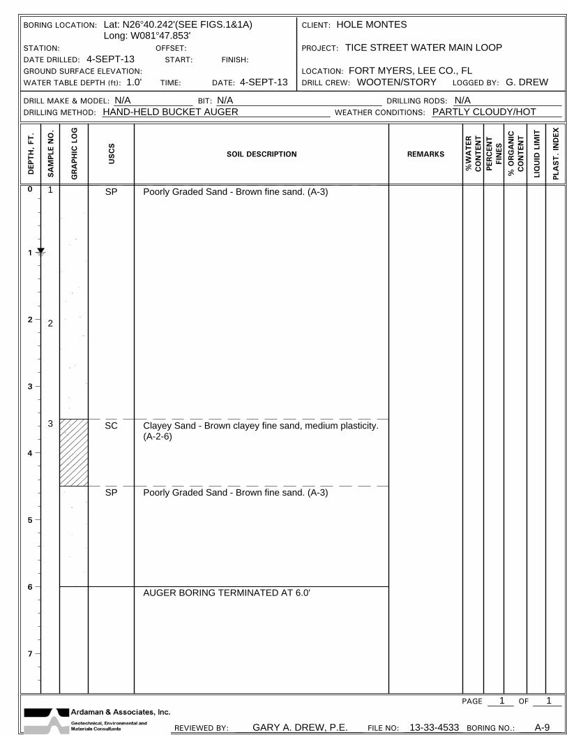
Poorly Graded Sand - Brown fine sand. (A-3)
Clayey Sand - Brown clayey fine sand, medium plasticity.(A-2-6)
Poorly Graded Sand - Brown fine sand. (A-3)
AUGER BORING TERMINATED AT 6.0'
BORING LOCATION: Lat: N26 40.242'(SEE FIGS.1&1A)Long: W081 47.853'
CLIENT: HOLE MONTES
STATION: OFFSET: PROJECT: TICE STREET WATER MAIN LOOPDATE DRILLED: 4-SEPT-13 START: FINISH:GROUND SURFACE ELEVATION: LOCATION: FORT MYERS, LEE CO., FLWATER TABLE DEPTH (ft): 1.0' TIME: DATE: 4-SEPT-13 DRILL CREW: WOOTEN/STORY LOGGED BY: G. DREW
DRILL MAKE & MODEL: N/A BIT: N/A DRILLING RODS: N/ADRILLING METHOD: HAND-HELD BUCKET AUGER WEATHER CONDITIONS: PARTLY CLOUDY/HOT
PAGE 1 OF
REVIEWED BY: GARY A. DREW, P.E. FILE NO: 13-33-4533 BORING NO.: A-9
DEP
TH
, FT
.
SA
MPL
E N
O.
GRA
PHIC
LO
G
USC
S
SOIL DESCRIPTION REMARKS
%W
ATER
CO
NTEN
TPE
RC
ENT
FIN
ES
% O
RG
AN
ICC
ON
TEN
T
LIQ
UID
LIM
IT
PLA
ST. IN
DEX
1

0
1
2
3
4
5
6
7
1
2
SP
SC-SM
Poorly Graded Sand - Brown fine sand. (A-3)
Silty Clayey Sand - Light gray silty clayey fine sand, lowplasticity. (A-2-4)
REFUSAL ON ROCK AT 2.5'
BORING LOCATION: Lat: N26 40.245'(SEE FIGS.1&1A)Long: W081 47.791'
CLIENT: HOLE MONTES
STATION: OFFSET: PROJECT: TICE STREET WATER MAIN LOOPDATE DRILLED: 4-SEPT-13 START: FINISH:GROUND SURFACE ELEVATION: LOCATION: FORT MYERS, LEE CO., FLWATER TABLE DEPTH (ft): 1.0' TIME: DATE: 4-SEPT-13 DRILL CREW: WOOTEN/STORY LOGGED BY: G. DREW
DRILL MAKE & MODEL: N/A BIT: N/A DRILLING RODS: N/ADRILLING METHOD: HAND-HELD BUCKET AUGER WEATHER CONDITIONS: PARTLY CLOUDY/HOT
PAGE 1 OF
REVIEWED BY: GARY A. DREW, P.E. FILE NO: 13-33-4533 BORING NO.: A-10
DEP
TH
, FT
.
SA
MPL
E N
O.
GRA
PHIC
LO
G
USC
S
SOIL DESCRIPTION REMARKS
%W
ATER
CO
NTEN
TPE
RC
ENT
FIN
ES
% O
RG
AN
ICC
ON
TEN
T
LIQ
UID
LIM
IT
PLA
ST. IN
DEX
1
0
1
2
3
4
5
6
7
1
2
3
SP
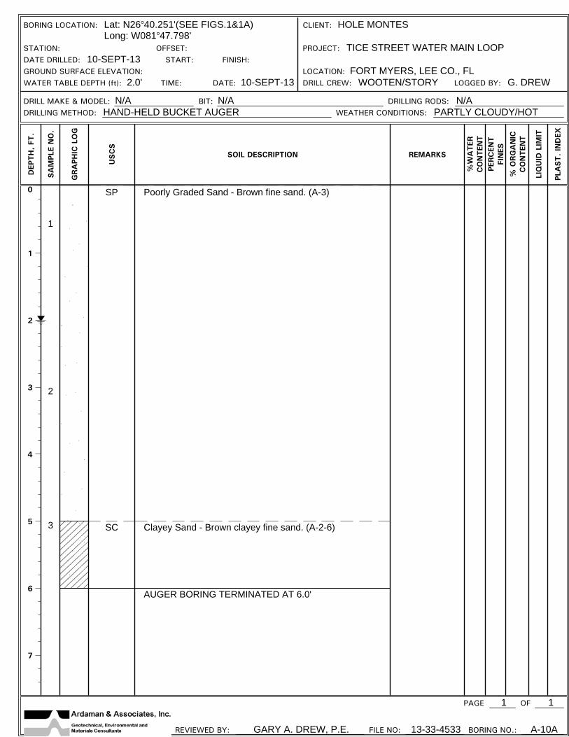
SC
Poorly Graded Sand - Brown fine sand. (A-3)
Clayey Sand - Brown clayey fine sand. (A-2-6)
AUGER BORING TERMINATED AT 6.0'
BORING LOCATION: Lat: N26 40.251'(SEE FIGS.1&1A)Long: W081 47.798'
CLIENT: HOLE MONTES
STATION: OFFSET: PROJECT: TICE STREET WATER MAIN LOOPDATE DRILLED: 10-SEPT-13 START: FINISH:GROUND SURFACE ELEVATION: LOCATION: FORT MYERS, LEE CO., FLWATER TABLE DEPTH (ft): 2.0' TIME: DATE: 10-SEPT-13 DRILL CREW: WOOTEN/STORY LOGGED BY: G. DREW
DRILL MAKE & MODEL: N/A BIT: N/A DRILLING RODS: N/ADRILLING METHOD: HAND-HELD BUCKET AUGER WEATHER CONDITIONS: PARTLY CLOUDY/HOT
PAGE 1 OF
REVIEWED BY: GARY A. DREW, P.E. FILE NO: 13-33-4533 BORING NO.: A-10A
DEP
TH
, FT
.
SA
MPL
E N
O.
GRA
PHIC
LO
G
USC
S
SOIL DESCRIPTION REMARKS
%W
ATER
CO
NTEN
TPE
RC
ENT
FIN
ES
% O
RG
AN
ICC
ON
TEN
T
LIQ
UID
LIM
IT
PLA
ST. IN
DEX
1
0
1
2
3
4
5
6
7
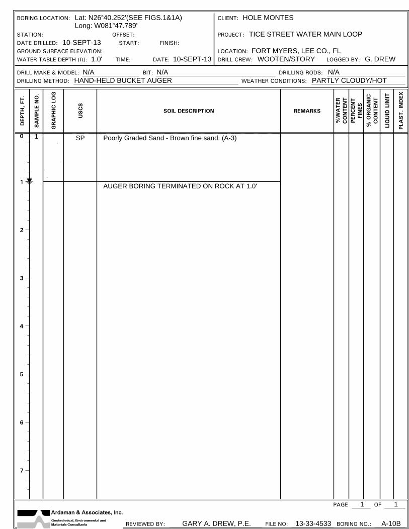
1 SP Poorly Graded Sand - Brown fine sand. (A-3)
AUGER BORING TERMINATED ON ROCK AT 1.0'
BORING LOCATION: Lat: N26 40.252'(SEE FIGS.1&1A)Long: W081 47.789'
CLIENT: HOLE MONTES
STATION: OFFSET: PROJECT: TICE STREET WATER MAIN LOOPDATE DRILLED: 10-SEPT-13 START: FINISH:GROUND SURFACE ELEVATION: LOCATION: FORT MYERS, LEE CO., FLWATER TABLE DEPTH (ft): 1.0' TIME: DATE: 10-SEPT-13 DRILL CREW: WOOTEN/STORY LOGGED BY: G. DREW
DRILL MAKE & MODEL: N/A BIT: N/A DRILLING RODS: N/ADRILLING METHOD: HAND-HELD BUCKET AUGER WEATHER CONDITIONS: PARTLY CLOUDY/HOT
PAGE 1 OF
REVIEWED BY: GARY A. DREW, P.E. FILE NO: 13-33-4533 BORING NO.: A-10B
DEP
TH
, FT
.
SA
MPL
E N
O.
GRA
PHIC
LO
G
USC
S
SOIL DESCRIPTION REMARKS
%W
ATER
CO
NTEN
TPE
RC
ENT
FIN
ES
% O
RG
AN
ICC
ON
TEN
T
LIQ
UID
LIM
IT
PLA
ST. IN
DEX
1

0
1
2
3
4
5
6
7
1
2
3
SP Poorly Graded Sand - Brown to light brown fine sand. (A-3)
AUGER BORING TERMINATED AT 6.0'
BORING LOCATION: Lat: N26 40.253'(SEE FIGS.1&1A)Long: W081 47.732'
CLIENT: HOLE MONTES
STATION: OFFSET: PROJECT: TICE STREET WATER MAIN LOOPDATE DRILLED: 4-SEPT-13 START: FINISH:GROUND SURFACE ELEVATION: LOCATION: FORT MYERS, LEE CO., FLWATER TABLE DEPTH (ft): 1.0' TIME: DATE: 4-SEPT-13 DRILL CREW: WOOTEN/STORY LOGGED BY: G. DREW
DRILL MAKE & MODEL: N/A BIT: N/A DRILLING RODS: N/ADRILLING METHOD: HAND-HELD BUCKET AUGER WEATHER CONDITIONS: PARTLY CLOUDY/HOT
PAGE 1 OF
REVIEWED BY: GARY A. DREW, P.E. FILE NO: 13-33-4533 BORING NO.: A-11
DEP
TH
, FT
.
SA
MPL
E N
O.
GRA
PHIC
LO
G
USC
S
SOIL DESCRIPTION REMARKS
%W
ATER
CO
NTEN
TPE
RC
ENT
FIN
ES
% O
RG
AN
ICC
ON
TEN
T
LIQ
UID
LIM
IT
PLA
ST. IN
DEX
1

0
1
2
3
4
5
6
7
1
2
3
SP
SP
SP
Poorly Graded Sand - Brown fine sand. (A-3)
Poorly Graded Sand - Yellowish-brown fine sand. (A-3)
Poorly Graded Sand - Brown fine sand. (A-3)
AUGER BORING TERMINATED AT 6.0'
BORING LOCATION: Lat: N26 40.252'(SEE FIGS.1&1A)Long: W081 47.676'
CLIENT: HOLE MONTES
STATION: OFFSET: PROJECT: TICE STREET WATER MAIN LOOPDATE DRILLED: 4-SEPT-13 START: FINISH:GROUND SURFACE ELEVATION: LOCATION: FORT MYERS, LEE CO., FLWATER TABLE DEPTH (ft): .5' TIME: DATE: 4-SEPT-13 DRILL CREW: WOOTEN/STORY LOGGED BY: G. DREW
DRILL MAKE & MODEL: N/A BIT: N/A DRILLING RODS: N/ADRILLING METHOD: HAND-HELD BUCKET AUGER WEATHER CONDITIONS: PARTLY CLOUDY/HOT
PAGE 1 OF
REVIEWED BY: GARY A. DREW, P.E. FILE NO: 13-33-4533 BORING NO.: A-12
DEP
TH
, FT
.
SA
MPL
E N
O.
GRA
PHIC
LO
G
USC
S
SOIL DESCRIPTION REMARKS
%W
ATER
CO
NTEN
TPE
RC
ENT
FIN
ES
% O
RG
AN
ICC
ON
TEN
T
LIQ
UID
LIM
IT
PLA
ST. IN
DEX
1

0
1
2
3
4
5
6
7
1
2
3
SP
SP
SP
Poorly Graded Sand - Gray fine sand. (A-3)
Poorly Graded Sand - Yellowish-brown fine sand. (A-3)
Poorly Graded Sand with Gravel - Brown fine sand, somegravel-size shell and limerock fragments. (A-3)
AUGER BORING TERMINATED AT 6.0'
BORING LOCATION: Lat: N26 40.247'(SEE FIGS.1&1A)Long: W081 47.546'
CLIENT: HOLE MONTES
STATION: OFFSET: PROJECT: TICE STREET WATER MAIN LOOPDATE DRILLED: 29-AUG-13 START: FINISH:GROUND SURFACE ELEVATION: LOCATION: FORT MYERS, LEE CO., FLWATER TABLE DEPTH (ft): 3.0' TIME: DATE: 29-AUG-13 DRILL CREW: WOOTEN/STORY LOGGED BY: G. DREW
DRILL MAKE & MODEL: N/A BIT: N/A DRILLING RODS: N/ADRILLING METHOD: HAND-HELD BUCKET AUGER WEATHER CONDITIONS: PARTLY CLOUDY/HOT
PAGE 1 OF
REVIEWED BY: GARY A. DREW, P.E. FILE NO: 13-33-4533 BORING NO.: A-13
DEP
TH
, FT
.
SA
MPL
E N
O.
GRA
PHIC
LO
G
USC
S
SOIL DESCRIPTION REMARKS
%W
ATER
CO
NTEN
TPE
RC
ENT
FIN
ES
% O
RG
AN
ICC
ON
TEN
T
LIQ
UID
LIM
IT
PLA
ST. IN
DEX
1

0
1
2
3
4
5
6
7
1
2
3
SP
SC-SM
SP
Poorly Graded Sand - Brown fine sand. (A-3)
Silty Clayey Sand - Brown silty clayey fine sand, lowplasticity. (A-2-4)
Poorly Graded Sand with Gravel - Brown fine sand, somegravel-size shell and limerock fragments. (A-3)
AUGER BORING TERMINATED AT 6.0'
17 1.0
BORING LOCATION: Lat: N26 40.209'(SEE FIGS.1&1A)Long: W081 47.545'
CLIENT: HOLE MONTES
STATION: OFFSET: PROJECT: TICE STREET WATER MAIN LOOPDATE DRILLED: 29-AUG-13 START: FINISH:GROUND SURFACE ELEVATION: LOCATION: FORT MYERS, LEE CO., FLWATER TABLE DEPTH (ft): 3.0' TIME: DATE: 29-AUG-13 DRILL CREW: WOOTEN/STORY LOGGED BY: G. DREW
DRILL MAKE & MODEL: N/A BIT: N/A DRILLING RODS: N/ADRILLING METHOD: HAND-HELD BUCKET AUGER WEATHER CONDITIONS: PARTLY CLOUDY/HOT
PAGE 1 OF
REVIEWED BY: GARY A. DREW, P.E. FILE NO: 13-33-4533 BORING NO.: A-14
DEP
TH
, FT
.
SA
MPL
E N
O.
GRA
PHIC
LO
G
USC
S
SOIL DESCRIPTION REMARKS
%W
ATER
CO
NTEN
TPE
RC
ENT
FIN
ES
% O
RG
AN
ICC
ON
TEN
T
LIQ
UID
LIM
IT
PLA
ST. IN
DEX
1
0
5
10
15
20
25
30
35
4- 5- 4
6- 4- 4
5- 4- 4
3- 3- 3
4- 1- 4
2- 3- 2
2- 2- 2
9
8
8
6
5
5
4
1
2
3
4
5
6
7
8
SP
SC
SP
SM
SC-SM
Poorly Graded Sand - Brown fine sand. (A-3)
Clayey Sand - Brown clayey fine sand, mediumplasticity. (A-2-6)Poorly Graded Sand - Brown fine sand, tracegravel-size shell fragments. (A-3)
Silty Sand - Gray calcareous slightly silty finesand, trace gravel-size shell and limerockfragments. (A-2-4)
Silty Clayey Sand - Gray silty clayey fine sand,low plasticity, trace to some gravel-size limerockand shell fragments. (A-2-4)
SPT BORING TERMINATED AT 25.5'
Hand Augered to 4.5'Safety hammer 4.5 to 14'
Auto hammer 14' toTERM.
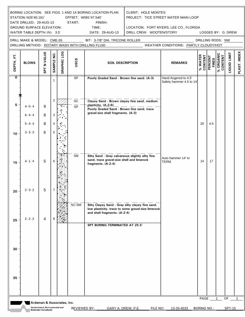
20
14
4.5
17
BORING LOCATION: SEE FIGS. 1 AND 1A BORING LOCATION PLAN CLIENT: HOLE MONTESSTATION: N26 40.161' OFFSET: W081 47.540' PROJECT: TICE STREET WATER MAIN LOOPDATE DRILLED: 29-AUG-13 START: FINISH:GROUND SURFACE ELEVATION: TIME: LOCATION: FORT MYERS, LEE CO., FLORIDAWATER TABLE DEPTH (ft): 3.5' DATE: 29-AUG-13 DRILL CREW: WOOTEN/STORY LOGGED BY: G. DREW
DRILL MAKE & MODEL: CME-55 BIT: 3-7/8" DIA. TRICONE ROLLER DRILLING RODS: NWDRILLING METHOD: ROTARY WASH WITH DRILLING FLUID WEATHER CONDITIONS: PARTLY CLOUDY/HOT
PAGE 1 OF
REVIEWED BY: GARY A. DREW, P.E. FILE NO: 13-33-4533 BORING NO.: SPT-15
DEP
TH
, FT
.
BLOWS
SPT
N-V
ALU
E
SA
MPL
E N
O.
GRA
PHIC
LO
G
USC
S
SOIL DESCRIPTION REMARKS
% W
ATER
CO
NTEN
T
PERC
ENT
FIN
ES
% O
RG
AN
ICC
ON
TEN
T
LIQ
UID
LIM
IT
PLA
ST. IN
DEX
1

0
5
10
15
20
25
30
35
5- 3- 3
3- 3- 3
3- 4- 4
4- 2- 2
1- 1- 1
1- 2- 2
1- 2- 1
6
6
8
4
2
4
3
1
2
3
4
5
6
7
8
SP
SC-SM
SP
SM
SC-SM
Poorly Graded Sand - Light brown fine sand. (A-3)
Silty Clayey Sand - Brown silty clayey fine sand,low plasticity. (A-2-4)Poorly Graded Sand - Brown fine sand, tracegravel-size shell fragments. (A-3)
Silty Sand - Gray calcareous slightly silty finesand, trace gravel-size shell and limerockfragments. (A-2-4)
Silty Clayey Sand - Gray silty clayey fine sand,low plasticity, trace gravel -size limerock andshell fragments. (A 2-4)
SPT BORING TERMINATED AT 25.5'
Hand Augered to 4.5'Safety hammer 4.5 to 14'
Auto hammer 14' toTERM.
BORING LOCATION: SEE FIG. 1 AND 1A BORING LOCATION PLAN CLIENT: HOLE MONTESSTATION: N26 40.142' OFFSET: W081 47.540' PROJECT: TICE STREET WATER MAIN LOOPDATE DRILLED: 29-AUG-13 START: FINISH:GROUND SURFACE ELEVATION: TIME: LOCATION: FORT MYERS, LEE CO., FLORIDAWATER TABLE DEPTH (ft): 3.5' DATE: 29-AUG-13 DRILL CREW: WOOTEN/STORY LOGGED BY: G. DREW
DRILL MAKE & MODEL: CME-55 BIT: 3-7/8" DIA. TRICONE ROLLER DRILLING RODS: NWDRILLING METHOD: ROTARY WASH WITH DRILLING FLUID WEATHER CONDITIONS: PARTLY CLOUDY/HOT
PAGE 1 OF
REVIEWED BY: GARY A. DREW, P.E. FILE NO: 13-33-4533 BORING NO.: SPT-16
DEP
TH
, FT
.
BLOWS
SPT
N-V
ALU
E
SA
MPL
E N
O.
GRA
PHIC
LO
G
USC
S
SOIL DESCRIPTION REMARKS
% W
ATER
CO
NTEN
T
PERC
ENT
FIN
ES
% O
RG
AN
ICC
ON
TEN
T
LIQ
UID
LIM
IT
PLA
ST. IN
DEX
1

0
1
2
3
4
5
6
7
1
2
3
SP
SC
SP
Poorly Graded Sand - Light brown fine sand. (A-3)
Clayey Sand - Gray clayey fine sand, medium plasticity. (A-2-6)
Poorly Graded Sand with Gravel - Brown fine sand, somegravel-size shell and limerock fragments. (A-3)
AUGER BORING TERMINATED AT 6.0'
20 3.3
BORING LOCATION: Lat: N26 40.094'(SEE FIGS.1&1A)Long: W081 47.540'
CLIENT: HOLE MONTES
STATION: OFFSET: PROJECT: TICE STREET WATER MAIN LOOPDATE DRILLED: 29-AUG-13 START: FINISH:GROUND SURFACE ELEVATION: LOCATION: FORT MYERS, LEE CO., FLWATER TABLE DEPTH (ft): 3.5' TIME: DATE: 29-AUG-13 DRILL CREW: WOOTEN/STORY LOGGED BY: G. DREW
DRILL MAKE & MODEL: N/A BIT: N/A DRILLING RODS: N/ADRILLING METHOD: HAND-HELD BUCKET AUGER WEATHER CONDITIONS: PARTLY CLOUDY/HOT
PAGE 1 OF
REVIEWED BY: GARY A. DREW, P.E. FILE NO: 13-33-4533 BORING NO.: A-17
DEP
TH
, FT
.
SA
MPL
E N
O.
GRA
PHIC
LO
G
USC
S
SOIL DESCRIPTION REMARKS
%W
ATER
CO
NTEN
TPE
RC
ENT
FIN
ES
% O
RG
AN
ICC
ON
TEN
T
LIQ
UID
LIM
IT
PLA
ST. IN
DEX
1
0
1
2
3
4
5
6
7
1
2
3
SP
SC-SM
SP
Poorly Graded Sand - Light gray fine sand. (A-3)
Silty Clayey Sand - Yellowish-brown silty clayey fine sand,low plasticity. (A-2-4)
Poorly Graded Sand with Gravel - Brown fine sand, somegravel-size shell and limerock fragments. (A-3)
AUGER BORING TERMINATED AT 6.0'
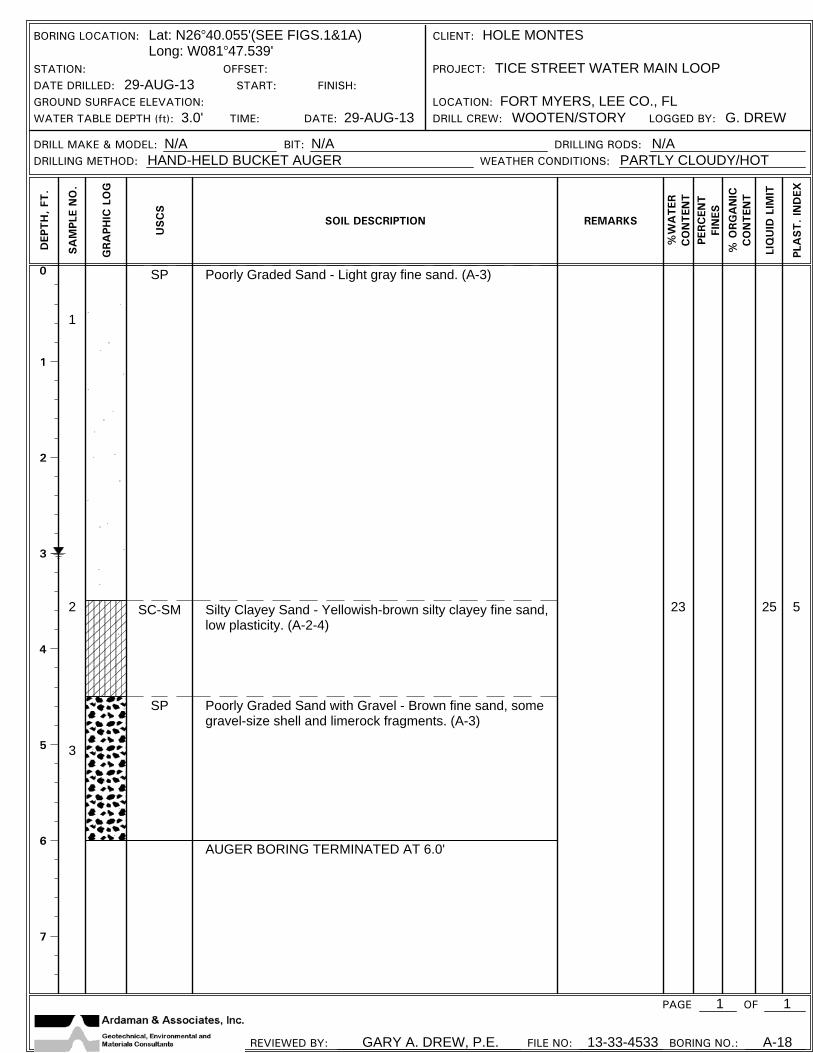
23 25 5
BORING LOCATION: Lat: N26 40.055'(SEE FIGS.1&1A)Long: W081 47.539'
CLIENT: HOLE MONTES
STATION: OFFSET: PROJECT: TICE STREET WATER MAIN LOOPDATE DRILLED: 29-AUG-13 START: FINISH:GROUND SURFACE ELEVATION: LOCATION: FORT MYERS, LEE CO., FLWATER TABLE DEPTH (ft): 3.0' TIME: DATE: 29-AUG-13 DRILL CREW: WOOTEN/STORY LOGGED BY: G. DREW
DRILL MAKE & MODEL: N/A BIT: N/A DRILLING RODS: N/ADRILLING METHOD: HAND-HELD BUCKET AUGER WEATHER CONDITIONS: PARTLY CLOUDY/HOT
PAGE 1 OF
REVIEWED BY: GARY A. DREW, P.E. FILE NO: 13-33-4533 BORING NO.: A-18
DEP
TH
, FT
.
SA
MPL
E N
O.
GRA
PHIC
LO
G
USC
S
SOIL DESCRIPTION REMARKS
%W
ATER
CO
NTEN
TPE
RC
ENT
FIN
ES
% O
RG
AN
ICC
ON
TEN
T
LIQ
UID
LIM
IT
PLA
ST. IN
DEX
1

0
1
2
3
4
5
6
7
1
2
3
SP
SC-SM
SP
Poorly Graded Sand - Brown fine sand. (A-3)
Silty Clayey Sand - Brown silty clayey fine sand, lowplasticity. (A-2-4)
Poorly Graded Sand with Gravel - Brown fine sand, somegravel-size shell and limerock fragments. (A-3)
AUGER BORING TERMINATED AT 6.0'
BORING LOCATION: Lat: N26 40.017'(SEE FIGS.1&1A)Long: W081 47.536'
CLIENT: HOLE MONTES
STATION: OFFSET: PROJECT: TICE STREET WATER MAIN LOOPDATE DRILLED: 29-AUG-13 START: FINISH:GROUND SURFACE ELEVATION: LOCATION: FORT MYERS, LEE CO., FLWATER TABLE DEPTH (ft): 3.5' TIME: DATE: 29-AUG-13 DRILL CREW: WOOTEN/STORY LOGGED BY: G. DREW
DRILL MAKE & MODEL: N/A BIT: N/A DRILLING RODS: N/ADRILLING METHOD: HAND-HELD BUCKET AUGER WEATHER CONDITIONS: PARTLY CLOUDY/HOT
PAGE 1 OF
REVIEWED BY: GARY A. DREW, P.E. FILE NO: 13-33-4533 BORING NO.: A-19
DEP
TH
, FT
.
SA
MPL
E N
O.
GRA
PHIC
LO
G
USC
S
SOIL DESCRIPTION REMARKS
%W
ATER
CO
NTEN
TPE
RC
ENT
FIN
ES
% O
RG
AN
ICC
ON
TEN
T
LIQ
UID
LIM
IT
PLA
ST. IN
DEX
1

Ardaman & Associates, Inc.
APPENDIX 2 • GRAIN-SIZE ANALYSIS SHEET

4 412100
80
90
70
60
50
40
30
20
10
0
PE
RC
EN
T F
INE
R B
Y W
EIG
HT
0
20
10
30
40
50
60
70
80
90
100
PE
RC
EN
T C
OA
RS
ER
BY
WE
IGH
T
0.001500 100 1 0.1 0.0150 10 5 0.5 0.0050.05
6 3 1 1 3 6 8 10 14 2016 30 40 50 70 100 2001402 34
38
12
U.S. STANDARD SIEVE OPENING IN INCHES U.S. STANDARD SIEVE NUMBERS HYDROMETER
GRAIN SIZE IN MILLIMETERS
SILT OR CLAYGRAVEL
20
COARSE FINE
GRADATION CURVES
Test Hole
Elev or Depth
Sample Description UnifiedClass -200NM % PI
SP
1
SEPT-2013
Tice Street Water Main LoopFort Myers, Lee Co., FL
13-33-4533
Poorly Graded Sand with Gravel.
5'
4 412
80
90
70
60
50
40
30
20
10
0
PE
RC
EN
T F
INE
R B
Y W
EIG
HT
0
20
10
30
40
50
60
70
80
90
100
PE
RC
EN
T C
OA
RS
ER
BY
WE
IGH
T
0.001500 100 1 0.1 0.0150 10 5 0.5 0.0050.05
6 3 1 1 3 6 8 10 14 2016 30 40 50 70 100 2001402 34
38
12
U.S. STANDARD SIEVE OPENING IN INCHES U.S. STANDARD SIEVE NUMBERS HYDROMETER
GRAIN SIZE IN MILLIMETERS
COBBLESSAND
Poorly Graded Sand with Gravel.
SP
COARSE
4.5
SampleNo.
Gary A. Drew, P.E., Branch Manager
Symbol
SPT-15
SPT-17
4
3
7' •20 3.3
NP
NP
FINE MEDIUM
GDES

Ardaman & Associates, Inc.
APPENDIX 3 • SOIL BORING, SAMPLING AND TESTING METHODS
PROJECT SOIL DESCRIPTION PROCEDURE – UNIFIED AND AASHTO