39
Südlenzspitze–Nadelhorn Traverse Saas-Fee, Valais 12-13 July, 2010 Guides: Rudolf (Rütschi) Pollinger and Thomas Zumtaugwald
| Date post: | 20-Dec-2015 |
| Category: |
Documents |
| View: | 222 times |
| Download: | 2 times |

Südlenzspitze–Nadelhorn TraverseSaas-Fee, Valais12-13 July, 2010
Guides: Rudolf (Rütschi) Pollinger
and Thomas Zumtaugwald

Here is an overview of the tour. We start at the huts (circled), ascend up the ridge on the left through mixed snow and rock to the so-called grand gendarme (X), then to the summit of Lenzspitze, on the left. Proceeding to the right across the connecting ridge to Nadelhorn (the peak to the right), we then turn right and descend to the snowy Windjoch. From there it’s straight down to the flat surface of the Ried glacier. After crossing the glacier we rejoin the track back down to the huts.

The day before. Because it’s early in the season and we know the tour will be demanding, we decide to take the lift to Hannig and skip 400 meters of vertical climb to the Mischabel hut. Here is J at the signpost near Hannig, setting out. The tallest peak is our first goal – Lenzspitze (locally called Südlenz) – over 2000 meters above J’s head!

There is still a longish traverse from Hannig to the intersection with the all-too-familiar zigzag track from Saas Fee to the dark ridge and rock climbing section of the hut ascent (Distelhorn). We take our time, snap pix and drink a lot. From the ridge you can look up and see the lower reaches of the Ried glacier, breaking up on its way down to form the Distelbach.

It takes us 3 hours and 45 minutes to get to the huts (yes, there are two, an older one and a newer one, perched close together at 3340 m). Here is M just minutes before we arrive, with one of tomorrow’s objectives (Südlenzspitze) in the background.

The Lomatters (the hut wardens) are surprised to see us at the hut again only 5 days after we visited for acclimatization (not knowing whether we would be able to do Südlenz, we had said good bye to them for the summer). Here is a Lomatter family portrait, 3 generations.

One of our guides, Thomas Zumtaugwald (left), did a tour with other clients this morning, and is waiting for us at the hut. This season he and R – good buddies and teammates on the Patrouille des Glaciers this past spring -- are competing with one another to set the record for the hut ascent. R arrives at a gallop and announces in triumph his time of 1 hour 29 minutes: “Beat you by a minute, Tommy!”
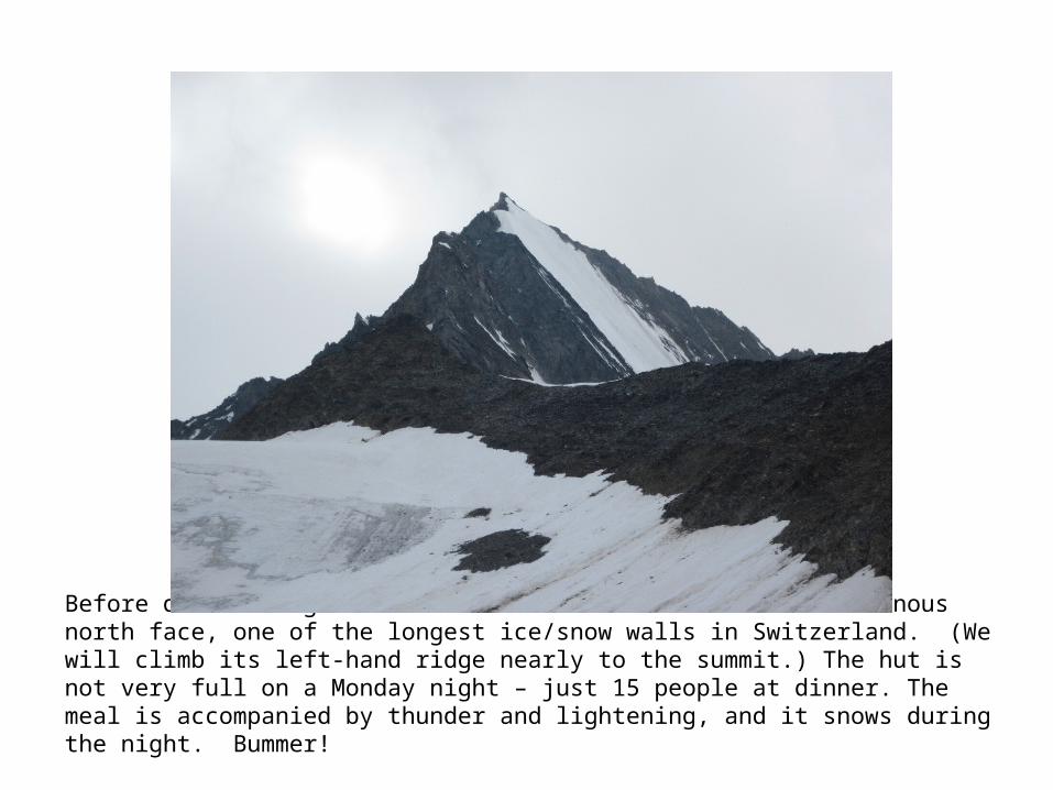
Before dinner we get this nice shot of Südlenz and its luminous north face, one of the longest ice/snow walls in Switzerland. (We will climb its left-hand ridge nearly to the summit.) The hut is not very full on a Monday night – just 15 people at dinner. The meal is accompanied by thunder and lightening, and it snows during the night. Bummer!

The tour. We are up at 2:55, and set off at 3:30 after a quick breakfast. The initial route is a long, winding walk through boulders, and we encounter new snow already at 3800 meters. We are the first party to head up the ridge to Südlenz. The surface of the rock is slick due to very fine, soft snow. Concentrate on every step! Jeff watches the play of lightening off to the south, above Milano, and begins to worry until T tells him the bad weather is retreating. R takes the first artistic photo of the day at 4:22 (it’s Jeff, and the photo is later featured on R’s website).
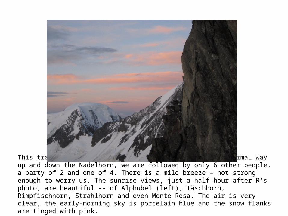
This traverse route is harder and much longer than the normal way up and down the Nadelhorn, we are followed by only 6 other people, a party of 2 and one of 4. There is a mild breeze – not strong enough to worry us. The sunrise views, just a half hour after R’s photo, are beautiful -- of Alphubel (left), Täschhorn, Rimpfischhorn, Strahlhorn and even Monte Rosa. The air is very clear, the early-morning sky is porcelain blue and the snow flanks are tinged with pink.

Here are J and R at 5 am, just beneath the ridge’s grand gendarme, at about 4000 meters.

…And J’s view down the ridge as Martha follows close behind.

Here are M and T in the classic shot on the grand gendarme. Ever since we saw a version of this photo by Kev Reynolds on the back cover of our Valais climbing book, we have dreamed of being here. Clearly it’s nowhere you can hang out long.

From the grand gendarme, we cannot see the next belay point. R reconnoiters without success, and decides to lower Jeff off the overhang, down into the unknown. J looks for a place to land and finds a (very!) small snowy perch.
Moving on quickly to the steepest part of the ascent to Südlenz, the loose rocks and slabs above the grand gendarme make R curse. We are able to take a break at 5:45.

We continue without Steigeisen, picking our way along the drier rocks as the ridge gets very narrow/sharp. Here M demonstrates how you hold on to the spine and walk sideways for safety.

The going is slow… an hour after we “finish off” the grand gendarme, we reach the juncture of the ridge with the great ice wall of the north face, at about 4130 m. Here is the view back to the gendarme. (Look closely – Someone is standing on it!)

…And the view down the ice/snow of the Südlenz north face. It’s about 500 meters down this sheer white wall. Terrifying … especially as it ends in a nasty Bergschrund.
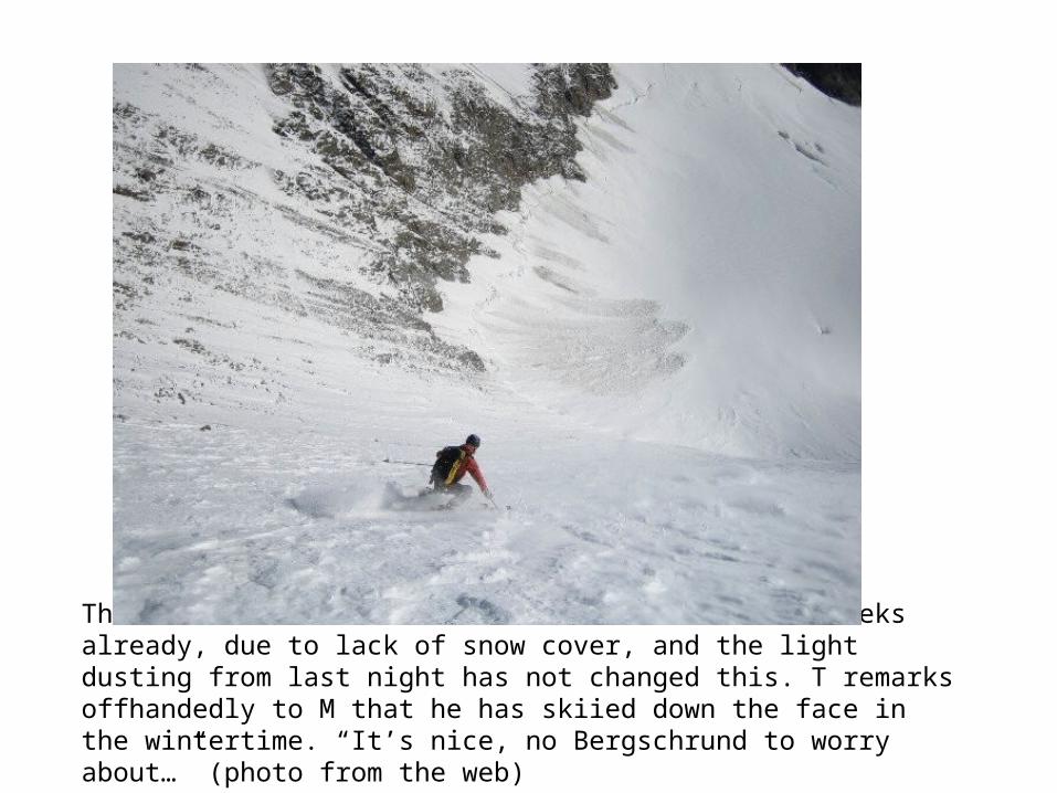
This season the ice wall has been ‘closed’ for weeks already, due to lack of snow cover, and the light dusting from last night has not changed this. T remarks offhandedly to M that he has skiied down the face in the wintertime. “It’s nice, no Bergschrund to worry about…” (photo from the web)

The last 180(?) meters up to the Südlenz summit are on very steep snow (to 55 degrees). In places there is just a thin layer on top of a hard, icy base. R hacks away with his Pickel in places to make footholds for us. Tommy also makes a couple of narrow shelves for M to stand on while waiting. We leave behind one ice screw in the toughest section, for the 2 guys behind us to use. This shows T and M starting up the snow field at about 7 am, with the north face dropping off to the left.
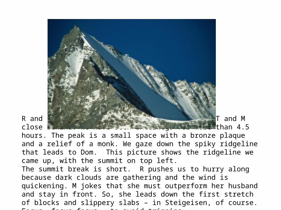
R and J reach the summit first, at 8:20, with T and M close behind. We have been unterwegs for more than 4.5 hours. The peak is a small space with a bronze plaque and a relief of a monk. We gaze down the spiky ridgeline that leads to Dom. This picture shows the ridgeline we came up, with the summit on top left.The summit break is short. R pushes us to hurry along because dark clouds are gathering and the wind is quickening. M jokes that she must outperform her husband and stay in front. So, she leads down the first stretch of blocks and slippery slabs – in Steigeisen, of course. Focus, focus focus – to avoid tripping...

The clouds part and then drift in again. In a wind-still spot we stop for some more photos, and we catch the Saas Fee party coming down from the Südlenz summit block on the section we just finished.

The stretch from the summit to the low point of the ridge that connects Südlenz with Nadelhorn (Verbindungsgrat) is described as an easy snow descent in the guidebooks – but it turns out to be quite difficult because there is no longer permanent snow. Many of the slabs forming the ridge crest are jagged and turned on end in a razorback profile. And, anywhere the ridge is still in shadow, there is ice on the slabs. Still in the lead, M regularly encounters ‘holes’ (a couple of meters’ drop) that she must slide down into, preferably on her feet but often on her butt, with an awkward hand-hold above. We notice that it is not actually cold, just windy. But at 10 am icy surfaces can still be a problem. You can see it in this shot of Jeff abseiling. The trick, they all say, is to lean as far back in the rope as possible and put maximum pressure on the rock face with your legs.
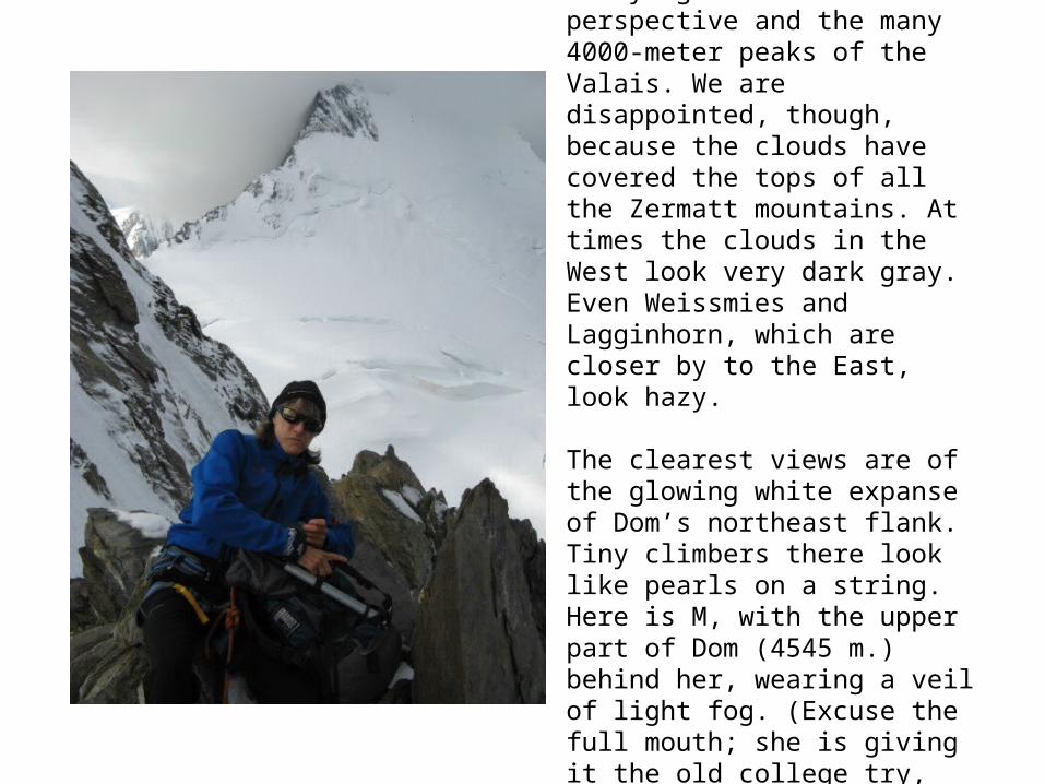
This ridge is famous for having amazing views in all directions, both the dizzying downward perspective and the many 4000-meter peaks of the Valais. We are disappointed, though, because the clouds have covered the tops of all the Zermatt mountains. At times the clouds in the West look very dark gray. Even Weissmies and Lagginhorn, which are closer by to the East, look hazy.
The clearest views are of the glowing white expanse of Dom’s northeast flank. Tiny climbers there look like pearls on a string. Here is M, with the upper part of Dom (4545 m.) behind her, wearing a veil of light fog. (Excuse the full mouth; she is giving it the old college try, chewing away at her roll, before resorting to a candy bar that goes down much easier….)
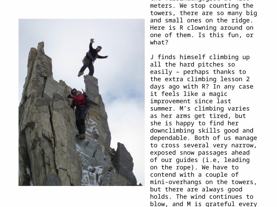
The rock is wonderful once we have passed the low point on the Verbindungsgrat at 4208 meters. We stop counting the towers, there are so many big and small ones on the ridge. Here is R clowning around on one of them. Is this fun, or what?
J finds himself climbing up all the hard pitches so easily – perhaps thanks to the extra climbing lesson 2 days ago with R? In any case it feels like a magic improvement since last summer. M’s climbing varies as her arms get tired, but she is happy to find her downclimbing skills good and dependable. Both of us manage to cross several very narrow, exposed snow passages ahead of our guides (i.e, leading on the rope). We have to contend with a couple of mini-overhangs on the towers, but there are always good holds. The wind continues to blow, and M is grateful every time she can wait for a belay on the lee side of a block or pinnacle.

From below, the Verbindungsgrat looks like a giant curtain – hung with a jagged top hem. The teeth get most extreme at the far end of the ridge, as you near Nadelhorn. (NB – Look hard; you can also see the huts!) SummitPost rates this part of the connecting ridge as a D (‘difficile’), with passages of IV.
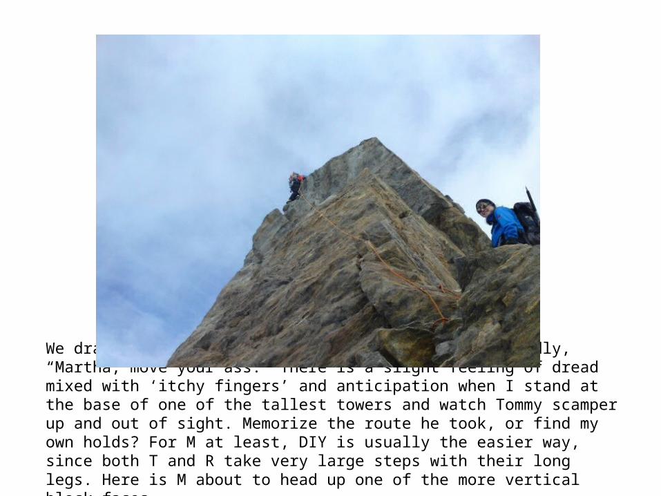
We drag a bit mid-ridge, and R calls out good-naturedly, “Martha, move your ass.” There is a slight feeling of dread mixed with ‘itchy fingers’ and anticipation when I stand at the base of one of the tallest towers and watch Tommy scamper up and out of sight. Memorize the route he took, or find my own holds? For M at least, DIY is usually the easier way, since both T and R take very large steps with their long legs. Here is M about to head up one of the more vertical block faces.

It is strange to do the whole rock-climbing traverse in gloves. Nice for the skin, but you often have to grab and grip with the whole palm of your hand. Jeff feels the finger tips on his Mammut gloves (cheap!!) shredding as he climbs. M tries to conserve energy by letting her arms extend into a ‘dead hang’ any time it’s necessary to use them for stabilizing or lowering herself. Bent arms and pumped biceps are a no-no. It’s amazing how, time after time, the strength is there to complete another pitch up a steep crack or face.Here are J and R on an easier part of the ‘adventure park’ terrain mid-ridge, with the Lenzspitze summit – and the iffy weather - behind.

The last, and broadest, gendarme on the ridge obscures the peak of Nadelhorn from quite a way off. It is a wonderful moment when M approaches the top of the tower and realizes there are only meters to go to the highest point of the tour (4327 meters). She is ahead of J and keeps quiet so he can also enjoy the welcome surprise. It has been a vexing illusion the whole time we are on the Verbindungsgrat, seeing the Gipfelkreuz on Nadelhorn pop into view and then disappear again behind some rock – always retreating just out of reach. In a burst of ambition and energy, we downclimb the last tower instead of abseiling. A quick scramble, and we are at the big metal summit cross. The 2.5 hours we took to traverse the Verbindungsgrat are packed with visual impressions and physical sensations. “Einfach sensationell!” Snacks and drinks and jokes and pictures of us – posing, we hope, for R’s website. T is a good sport and takes the pix.

As we start the descent, we remember how much more permanent snow there was on the summit rock back in 2001, on our first visit to Nadelhorn. The easy stuff is over after about 70 meters descent, and we have to put on Steigeisen. The snow from last night’s storm is deep, and our route, which runs very close to the corniced ridge crest, is trackless. We had already noticed mid-morning that there were no tracks on the normal ascent to Nadelhorn summit. All the climbers had apparently reached the Windjoch (3850 meters) and decided that the slog up another 475 meters in deep snow was too difficult. Some settled for Ulrichshorn, a closer and lower peak to the right. M curses her short pant legs and feels her boots fill with snow. It is tiring to hold the Pickel in one hand for so many steps. Sometimes, instead of supporting your weight, the point pokes right through the cornice and pulls you off balance. We are getting tired, and we stumble and lurch on the steep incline, as the top layer of snow slides on the base layer of ice. M manages to kick herself hard in the calf muscle – ouch! -- with a crampon spike.

Here is a view peering over the lip of one of those cornices; you can see the thin track of the Normalweg crossing the Ried glacier, and a bit of Saas Fee (upper left in the photo), more than 2,000 meters below.
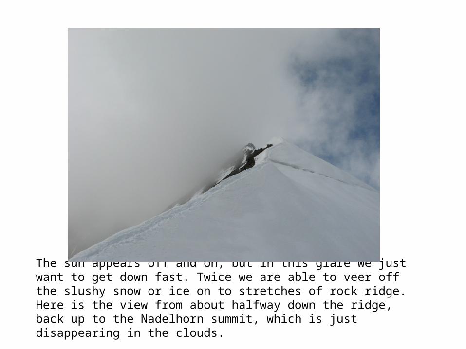
The sun appears off and on, but in this glare we just want to get down fast. Twice we are able to veer off the slushy snow or ice on to stretches of rock ridge. Here is the view from about halfway down the ridge, back up to the Nadelhorn summit, which is just disappearing in the clouds.

After an hour on extremely tilted terrain, it is a relief to reach the relative flatness of the Windjoch (3850 meters) . And there is no wind! We strip off some of our layers, and we know that the rest of the descent, while steep in parts, is straight down on a wide slope. Here is T at the Windjoch, in a great mood (happy with the rock climbing? Thinking he has only one more hour with these bozos?)

The snow is slushy and our gloves are soaked, as we half-slide and and tumble forwards, trying to avoid deep sinkholes as we approach the bottom of the glacier. Our thigh muscles burn with the effort – but we probably don’t look quite so laughable as we did the first time, at the end of the 10-hour Nadelgrat traverse in 2001. Here is J stopping to catch his breath, with the Windjoch behind and above him.
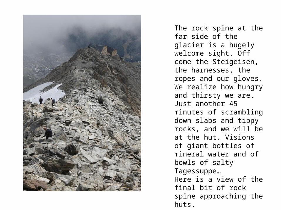
The rock spine at the far side of the glacier is a hugely welcome sight. Off come the Steigeisen, the harnesses, the ropes and our gloves. We realize how hungry and thirsty we are. Just another 45 minutes of scrambling down slabs and tippy rocks, and we will be at the hut. Visions of giant bottles of mineral water and of bowls of salty Tagessuppe… Here is a view of the final bit of rock spine approaching the huts.
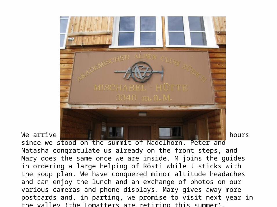
We arrive back at Mischabelhütten at 13:30, just 2.5 hours since we stood on the summit of Nadelhorn. Peter and Natasha congratulate us already on the front steps, and Mary does the same once we are inside. M joins the guides in ordering a large helping of Rösti while J sticks with the soup plan. We have conquered minor altitude headaches and can enjoy the lunch and an exchange of photos on our various cameras and phone displays. Mary gives away more postcards and, in parting, we promise to visit next year in the valley (the Lomatters are retiring this summer).

J and M pack up at 3 pm to start the jarring and steep climb down to the village, hoping to catch the last lift from Hannig at 16:45. But this is too optimistic. We descend the familiar rocky spine using all available aids – fixed ropes and pegs – but do not dare to pick a fast pace when we are this tired. Both have toe blisters, which burn with every step. Here’s a shot from the rock climbing part of the descent to Fee. You can see the zigzagging track in the green far below – the cross lending perhaps an appropriate pathos…

Just before it becomes obvious to M that we can’t make the lift, our guides breeze past us, looking fresh. They left the hut long after we did. Arghhh! We resign ourselves to the full descent on foot ... Frequent stops and ibuprofen make it possible. As we plod along, pain and pride battle it out. Once on the main street of Fee, we stop at the ‘cow trough’ fountain, the ice cold spring water a lasting tour highlight…. Outside the toy store, Birgit waves to us and startles us out of our trance. We realize that We are the Champions!!!

Statistics
Tour times:
Hannig lift station to huts – (3 hrs 45 mins)
Leave huts at 3:30, arrive at Südlenz summit 8:20 (4 hrs 40 mins)
Ridge from Südlenz to Nadelhorn summit – 8:35 to 11:05 (2 hrs 30 mins)
Nadelhorn summit to huts – 11:15 to 13:30 (2 hr 15 mins)
Huts to Saas Fee (including breaks) – 15:00 to 18:00 (3 hrs)
Total tour time: 9 hrs 25 mins
(16 hours including hut climbs)

Statistics
Key altitudes (in meters):Saas Fee 1800Hannig lift station 2300Huts 3340 m (1040 up from Hannig, 1540 up from Fee)Südlenzspitze 4294Low point on connecting ridge 4208Nadelhorn 4327Windjoch 3850Total altitude gain (not counting the gendarmes) 2215 metersTotal descent (not counting the gendarmes) 2715 meters
Key distances:Huts to Südlenz 3.2 kmSüdlenz to Nadelhorn 1.2 km – many, many ups and downs!Nadelhorn to Windjoch 1.3 kmWindjoch to huts 2.5 kmHuts to Saas Fee 7 km (including the many switchbacks)Total tour: 8.2 km (hard to calculate with the gendarmes)Total round trip from Saas Fee: 15.5-16 km


