1 DRAFT Decision Notice Big Red Timber Management Analysis Environmental Assessment USDA Forest Service Medicine Bow-Routt National Forests & Thunder Basin National Grassland Hahns Peak/Bears Ears Ranger District Routt County, Colorado Summary The USDA Forest Service (USFS), Hahns Peak/Bears Ears Ranger District, plans to manage approximately 1764 acres of forest lands in the Big Red Timber analysis area. This proposal is brought forward to advance the goals, objectives and desired conditions outlined in the Routt National Forest Land and Resource Management Plan 1997 Revision which is incorporated here by reference, and is hereinafter referred to as the Forest Plan. The primary intent of the Big Red Timber Management Analysis Project is to utilize silviculture, timber harvest and other forestry related practices to manage merchantable timber stands which have been significantly affected by mountain pine beetle, Dendroctonus ponderosae. This project was analyzed in the Big Red Timber Management Analysis Environmental Assessment, which is incorporated here by reference, and is hereinafter referred to as the EA. Based upon my review of the two alternatives being considered in the EA, the Proposed Action and a No Action Alternative, I have decided to implement Alternative 1, the Proposed Action. Purpose and Need As described in the EA, the purpose of this project is to advance the goals, objectives and desired conditions outlined in the Forest Plan by capturing marketable forest product values through timber harvest before the deterioration to assist in the need to: Manage mountain pine beetle affected timber stands to create optimum conditions for regeneration 1 , diversity 2 , vigor and resiliency 3 . Reduce the development of large continuous high hazard fuel conditions associated with widespread mountain pine beetle tree mortality. Protect public/private property and safety of forest users through management of beetle affected timber stands. Utilize opportunities associated with silvicultural and timber management methods to benefit other forest uses and resources. 1/ Assurance of natural regeneration or reforestation treatments if needed (FSM 2470). 2/Diversity in vegetation composition relative to proportions within the landscape and structural diversity relating to variation in sizes, shapes and pattern (heterogeneity) of landscape (vegetation) elements (Forest Plan EIS Glossary 5). 3/Ability of ecological systems to absorb disturbances while retaining the same basic ways of function, and the capacity to adapt to stress and change (FSM 2470, FSM 2020)
Transcript
1
DRAFT Decision Notice Big Red Timber Management Analysis
Environmental Assessment
USDA Forest Service
Medicine Bow-Routt National Forests &
Thunder Basin National Grassland
Hahns Peak/Bears Ears Ranger District
Routt County, Colorado
Summary The USDA Forest Service (USFS), Hahns Peak/Bears Ears Ranger District, plans to manage
approximately 1764 acres of forest lands in the Big Red Timber analysis area. This proposal is
brought forward to advance the goals, objectives and desired conditions outlined in the Routt
National Forest Land and Resource Management Plan 1997 Revision which is incorporated here
by reference, and is hereinafter referred to as the Forest Plan. The primary intent of the Big Red
Timber Management Analysis Project is to utilize silviculture, timber harvest and other forestry
related practices to manage merchantable timber stands which have been significantly affected
by mountain pine beetle, Dendroctonus ponderosae. This project was analyzed in the Big Red
Timber Management Analysis Environmental Assessment, which is incorporated here by
reference, and is hereinafter referred to as the EA. Based upon my review of the two alternatives
being considered in the EA, the Proposed Action and a No Action Alternative, I have decided to
implement Alternative 1, the Proposed Action.
Purpose and Need As described in the EA, the purpose of this project is to advance the goals, objectives and desired
conditions outlined in the Forest Plan by capturing marketable forest product values through
timber harvest before the deterioration to assist in the need to:
Manage mountain pine beetle affected timber stands to create optimum conditions for
regeneration1, diversity2, vigor and resiliency3.
Reduce the development of large continuous high hazard fuel conditions associated with
widespread mountain pine beetle tree mortality.
Protect public/private property and safety of forest users through management of beetle
affected timber stands.
Utilize opportunities associated with silvicultural and timber management methods to
benefit other forest uses and resources.
1/ Assurance of natural regeneration or reforestation treatments if needed (FSM 2470).
2/Diversity in vegetation composition relative to proportions within the landscape and structural diversity relating to variation in
sizes, shapes and pattern (heterogeneity) of landscape (vegetation) elements (Forest Plan EIS Glossary 5).
3/Ability of ecological systems to absorb disturbances while retaining the same basic ways of function, and the capacity to adapt
to stress and change (FSM 2470, FSM 2020)
2
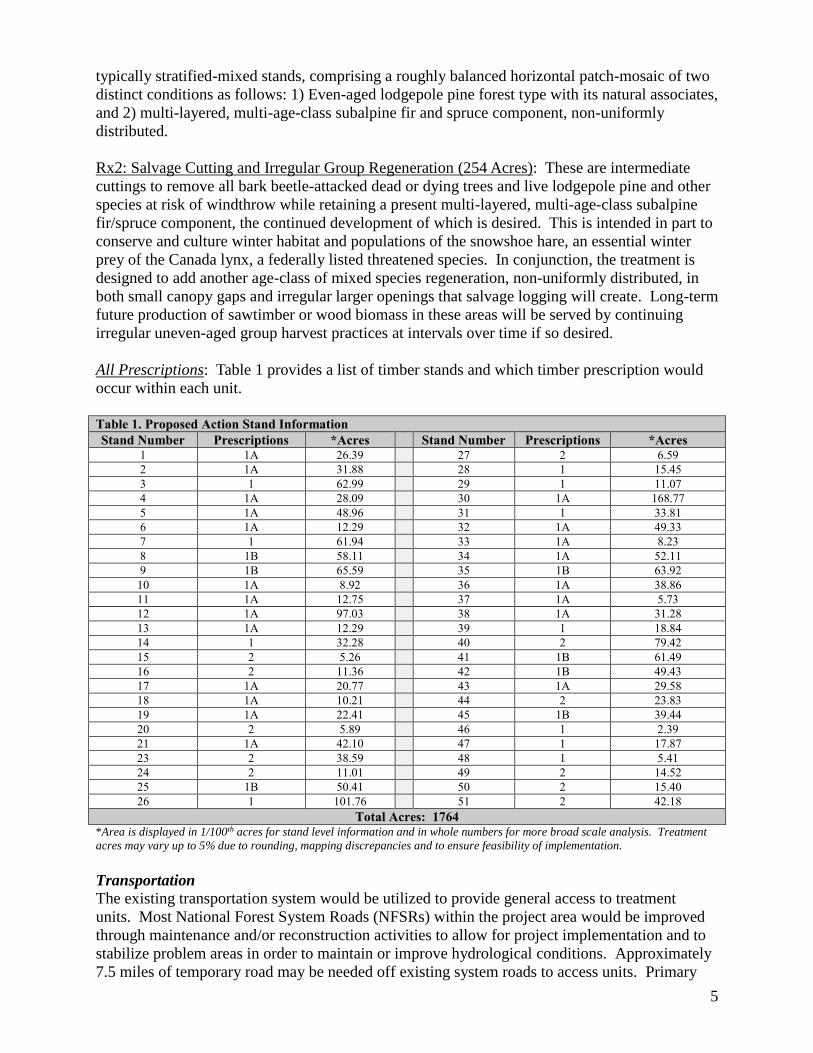
Project Location
The analysis area for the Big Red Timber Management Analysis is located on the Hahns
Peak/Bears Ears Ranger District of the Medicine Bow-Routt National Forests and Thunder Basin
National Grassland in Routt County, Colorado. It is located approximately 19 road miles north of
Clark, Colorado on USFS administered land (Appendix A, Figure 1). The legal description is
Township (T) 10 North (N), Range (R) 85 West (W) Sections 1, 2, 3, and 4; T11N R85W
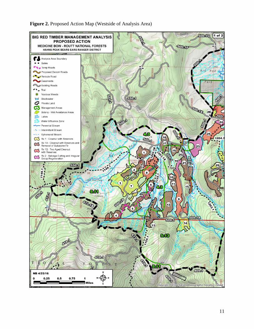
Figure 2. Proposed Action Map (Westside of Analysis Area)
12
Figure 3. Proposed Action Map (Eastside of Analysis Area)
13
Appendix B – Design Criteria for the Proposed Action
Project design criteria by resource area are included in this appendix and are included as part of the
proposed action.
Aquatic Resources
If specific impacts to threatened, endangered, and Region 2 sensitive species (TES)
and/or their habitats are identified, management may be adjusted as necessary to reduce
those impacts through working with the biologists or botanists. Timing restrictions may
also need to be applied. The TES species of interest include goshawks, raptors, pygmy
shrews, amphibians, and rare plants.
If contracts are used for implementation, final contract provisions relating to aquatic
wildlife resource protections, whether these needs are disclosed or not within this EA
and/or Decision Notice, would be the decision of the responsible aquatics biologist and/or
the district line officer.
Botanical
Botany Avoidance Areas are identified and will be protected by site specific measures,
contractual requirements or avoided.
Delineate a 100 ft. buffer around known occurrences of R2 sensitive and local concern
plant species and flag for avoidance.
Avoid any loss of rare wetlands such as fens and springs.
Where appropriate, revegetate project area with native species to reduce risk of invasive
species establishment and work with forest botanist to identify appropriate species for
planting.
Establish effective ground cover on disturbed sites to prevent accelerated on-site soil loss
and sediment delivery to streams. Restore ground cover using certified native plants as
practicable to meet revegetation objectives. Avoid persistent or invasive exotic plants.
Fell trees away from identified buffered populations.
Limit operations in buffered population areas to hand and/or non-ground disturbing
mechanical equipment. Unless identified as a fuel hazard, trees felled in buffered areas
would be left on site
Do not place or burn slash piles or broadcast burn slash in buffered areas.
Keep all slash out of perennial and intermittent stream courses, and all riparian areas and
wetlands. Do not accumulate slash in ephemeral stream courses.
Landings should be located in upland areas to minimize the potential for slash piles and
burning of slash to affect protected stream courses.
If contracts are used for implementation, final contract provisions relating to botanical
resource protections, whether these needs are disclosed or not within this EA and/or
Decision Notice, will be the decision of the responsible botanist and/or the district line
officer.
Fire & Fuels
Restrict slash piles to approximately 7068 ft³ or current Colorado Air Pollution Control
Division (CAPD) specifications (smoke permit limits efficient burning to a maximum
pile size of approximately (45’x20’x15’). For exemptions consult fire management
officer.
Burning in high moisture conditions will reduce the potential of an escaped fire. Follow
all applicable pile burn requirements specified in the CAPCD smoke permit and/or Routt
Zone programmatic pile burn plan.
14
Machine slash piles should be located at least twice their diameter from residual timber if
possible so damage will not occur during burning operations.
Machine slash piles shall be located at least 1/8th mile away from any residence and hand
piles shall be located at least 100’ from any residence.
If contracts are used for implementation, final contract provisions relating to fire and
fuels resource protections, whether the need is disclosed or not within this EA and/or
Decision Notice, will be the decision of the responsible fire management officer and/or
district line officer.
Heritage
All proposed temporary road corridors outside of unit boundaries that have not been
adequately surveyed for cultural resources will be identified during sale preparation and
approximate locations will be provided to the archeologist for review, which will be
completed prior to sale implementation.
Significant cultural and/or paleontological resources in the project area should be avoided
or the effects of project implementation otherwise mitigated based decisions identified
during analysis of the undertaking under the National Historic Preservation Act and other
relevant cultural resource protection laws and regulations, and consideration of the
undertaking’s effects to historic properties.
If in connection with operations under this authorization any of the above resources are
encountered, or previously unidentified resources are encountered, work shall be
immediately suspend all activities in the immediate vicinity of the discovery that might
further disturb such materials. Notify the Medicine Bow-Routt National Forests
authorized officer of the findings. The discovery must be protected until notified in
writing to proceed by the authorized officer (36 CFR 800.110 & 112, 43 CFR 10.4).
If affected properties are discovered after project activities are completed, the District
would document any damage and consult with SHPO and the Advisory Council for
Historic Preservation pursuant to 800.13(b).
If contracts are used for implementation, final contract provisions relating to heritage
resource protections, whether the protection need was disclosed or not within this EA
and/or Decision Notice, will be the decision of the responsible archeologist and/or district
line officer.
Hydrologic & Watershed
“The management measures and associated design criteria for this project address
hydrologic function, riparian areas, water quality, sediment control, and soil quality if the
standards set forth in the Forest Service National Core Best Management Practices
(BMP) Technical Guide, the Rocky Mountain Region Watershed Conservation Practices
(WCP) Forest Service Handbook 2509.25, the Routt National Forest Land and Resource
Management Plan 1997 Revision (Forest Plan), and the Forestry Best Management
Practices to Protect Water Quality in Colorado (2010) are followed to the degree
commensurate with project impacts. “
o USDA Forest Service, 2012. National Best Management Practices for Water
Quality Management on National Forest System Lands. FS-990a, Vol.1: National
Core BMP Technical Guide. Washington, DC: U.S. Department of Agriculture,
Forest Service. 165p.
o USDA Forest Service, 2006. Rocky Mountain Region Watershed Conservation
Practices (WCP). Forest Service Handbook 2509.25
15
o USDA Forest Service, 1997. Routt National Forest Land and Resource
Management Plan 1997 Revision
o Forestry Best Management Practices to Protect Water Quality in Colorado. Fort
Collins, Colo.: Colorado State Forest Service, 2010. Print.
Locations of all specified roads, stream crossings, and new temporary roads not analyzed
in the proposed action will be approved on site by a hydrologist. Additionally, use
hardened fords rather than culverts for stream crossings, outslope roads with rolling dips
and/or waterbars, and ensure adequate road drainage for all weather conditions.
Keep skid trails, landings, and slash piles out of the Water Influence Zone (WIZ) except
when approved by a hydrologist. Note – the water influence zone (WIZ) is the land adjacent to streams, lakes, and wetlands where vegetation plays a key
role in sustaining the structure, function, and processes of aquatic ecosystems. The WIZ includes the geomorphic
floodplain, riparian ecosystem, and inner gorge. As a non-site-specific rule of thumb, its minimum horizontal distance
(taken from the top of each bank) is 100 feet or the average height of the mature dominant late-seral vegetation,
whichever is greater.
When no longer needed, immediately close all temporary roads, spurs, landings, and skid
trails by re-contouring, scarifying, slashing, and seeding as necessary so hillslope
hydrology is restored.
Unit 12 - Restrict mechanical equipment within the WIZ and access timber off of NFSR
509.
Unit 13 - Restrict mechanical equipment outside of established treatment stand
boundaries and minimize the number of skid trails and landings within treatment stand.
Units 15, 23, 26 - Restrict mechanical equipment near unstable cliff walls
Units 27, 51 - Restrict mechanical equipment within the WIZ
Unit 34 - Restrict mechanical equipment within the WIZ and Restrict mechanical
equipment near unstable cliff walls
If contracts are used for implementation, final contract provisions relating to hydrologic
resource protections, whether the need was disclosed or not within this EA and/or
Decision Notice, will be the decision of the responsible hydrologist and/or district line
officer.
Rangeland
Locate and use weed free project staging areas e.g., landing areas.
Avoid or minimize all types of travel through weed infested areas, or restrict to those
periods when spread of seed or propagules are least likely. If questions arise consult
noxious weed coordinator.
Remove mud, dirt, and plant parts from equipment before moving it into a project area.
Clean all equipment before leaving a sale unit/units if operating in areas infested with
weeds. A population of yellow toadflax currently exists in Unit 1. Two additional
populations are known to exist along FSR 550 which would be used as a transportation
route for equipment and logging trucks. It is not anticipated that operations would have
any negative effect on the populations along FSR 550.
Minimize soil disturbance to the extent practical. Where logging activity creates bare
ground, re-establish vegetation to prevent establishment of weeds.
Inspect ground disturbing operations in noxious weed infested areas for at least three to
five growing seasons following completion of the project. For on-going projects,
continue to monitor until reasonable certainty is obtained that no weeds have occurred.
Provide for follow-up treatments based on inspection results.
Abide by provision RO-C6.223 and/or B6.22 (protection of fences) in Big Red analysis
area. A private inholding in Big Red Park is fenced along units 45, 47, and 26. Trees
16
should be logged up to the private land fence where practicable to prevent further damage
to the fence from falling trees.
The fences along the private property are the property of the land owner and will not be
cut, moved, or altered in any manner without prior consultation and approval of the land
owner.
If contracts are used for implementation, final contract provisions relating to rangeland
resource protections, whether the need was disclosed or not within this EA and/or
Decision Notice, will be the decision of the responsible rangeland manager and/or district
line officer.
Recreation
Work with recreation staff, and/or landscape architect to improve current travel
management. Coordinate layout of skid trails and temporary roads to prevent “road
creep” after sale closure, by designing natural or man-made barriers. Utilize new routes
as opportunities for dispersed site replacement away from water zones.
Closure of temp roads, skid trails and any other travel corridors purposefully or not
developed by logging activities will be closed in the timber contract or post sale activities
to include trust fund allocations by methods determined to be effective by the recreation
staff and/or line officer.
During sale layout, work with recreation/trails staff on specific tactics to accomplish trial
management objectives (TMO). Review trails and trailheads within units for either
protection or relocation within the timber sale unit to meet existing TMO for those trails.
Take advantage of this opportunity to improve poor trail location. If protection, identify
in the timber sale contract (PI). If trails or trailheads are not to be protected, identify
alternate routes to meet the TMO’s and rehabilitate closed segment to previous grade.
Trails and trailheads within identified logging units need to be protected or improved in
the timber sale contract, especially if impacted – rehabilitated to previous grade, profile
and drainage per the approved trail management objectives. During sale layout, work
with recreation/trails staff on specific tactics to accomplish trial management objectives.
If not feasible, identify alternate routes to maintain the recreational opportunity.
Allow recreation/trails staff to provide input on temporary road and skid trail locations,
where enhancements to the trails system may result from implementation.
Allow recreation specialists to identify segments of trail not to protect within units, and
replaced with segments in more desirable locations within the timber sale units.
Operations – close and sign trails in units where operations are occurring. Limit
operations to confined areas (e.g. operating in only one subdivision at a time) to minimize
impacts to OHV users. Prohibit operations during the first weekend of the four Colorado
Big Game Hunting Seasons, and prohibit hauling during the July 4th Holiday and Labor
Day weekends.
Units 1 and 8 are in the vicinity of the Ellis North Trailhead, and “Kid’s Trail” (NFST
1203.1B). Coordinate with recreation, trails and landscape architect on the long term
management of this trailhead.
Winter Operations – No winter plowing north on NFSR 550 from the junction with
NFSR 500 due to groomed snowmobile trail system. NFSR 550 and 500 are groomed
snowmobile routes. During the LSN analysis, the District and Steamboat Lake
Snowmobile Club identified alternate snowmobile routes, this assessment can be re-used
in the analysis. If this occurs, alternate routes will need to cross plowed roads at
designated locations, safety plan including signs will be necessary. Berms will need to
be pushed back on plowed roads to allow from snowmobile crossing.
17
If winter plowing is feasible as defined by the district recreation staff for the portion of
NFSR 550 from County Road 129 to the junction of NFSR 500, then temporary
replacement routes will need to be approved if feasible. Include mitigation and signing
requirements in the timber sale contract as a responsibility of the purchaser with
coordination of recreation staff.
District recreation staff and district line officer only will dictate whether any winter
operations will be included in any particular contract.
Outfitter and Guides – The District has outfitter and guides who use these routes to
access their operations. Allow access to the Hare and other trailheads if access is closed
to the general public. Permit Administrators may be able to work with permittees for
alternate routes, but if not feasible, allow access regardless of timber activity.
Keep temp roads and/or skid trails open into Unit 45 or any other unit as determined by
district recreation staff for dispersed camping activities to offset impacts of this project.
If contracts are used for implementation, final contract provisions relating to recreation
resource protections, whether the need was disclosed or not within this EA and/or
Decision Notice, will be the decision of the responsible recreation staff and/or district line
officer.
Soils
“The management measures and associated design criteria for this project address
hydrologic function, riparian areas, water quality, sediment control, and soil quality if the
standards set forth in the Forest Service National Core Best Management Practices
(BMP) Technical Guide, the Rocky Mountain Region Watershed Conservation Practices
(WCP) Forest Service Handbook 2509.25, the Routt National Forest Land and Resource
Management Plan 1997 Revision (Forest Plan), and the Forestry Best Management
Practices to Protect Water Quality in Colorado (2010) are followed to the degree
commensurate with project impacts. “
o USDA Forest Service, 2012. National Best Management Practices for Water
Quality Management on National Forest System Lands. FS-990a, Vol.1: National
Core BMP Technical Guide. Washington, DC: U.S. Department of Agriculture,
Forest Service. 165p.
o USDA Forest Service, 2006. Rocky Mountain Region Watershed Conservation
Practices (WCP). Forest Service Handbook 2509.25
o USDA Forest Service, 1997. Routt National Forest Land and Resource
Management Plan 1997 Revision
o Forestry Best Management Practices to Protect Water Quality in Colorado. Fort
Collins, Colo.: Colorado State Forest Service, 2010. Print.
Keep heavy equipment out of streams, swales, and lakes, except to cross at designated
points, build crossings, or do restoration work, or if protected by at least 1 foot of packed
snow or 2 inches of frozen soil.
Locate new concentrated-use sites outside the WIZ if practicable and outside riparian
areas and wetlands. Armor or reclaim existing sites in the WIZ to prevent detrimental
soil and bank erosion.
It is recommended that temporary roads and main skid trails, unless needed for post-
harvest activities, be recontoured and stabilized by ground cover such as but not limited
to seeding, mulching, slash cover, and/or other suitable means to any degree determined
by ranger district staff to reduce and dissipate concentrated overland flows.
Do not excavate earth material from, or store excavated earth material in, any stream,
swale, lake, wetland, or WIZ.
18
If contracts are used for implementation, final contract provisions relating to soils
resource protections, whether the need was disclosed or not within this EA and/or
Decision Notice, will be the decision of the responsible soils scientist and/or district line
officer.
Transportation
Road closure devices, including gates, barriers, slash or other devices needed to prohibit
or eliminate use, would be located on the ground to provide the most effective means of
accomplishing the desired travel management strategy. Keep heavy equipment out of
streams, swales, and lakes, except to cross at designated points, build crossings, or do
restoration work, or if protected by at least 1 foot of packed snow or 2 inches of frozen
soil.
Physical closures, such as slash, stumps, rocks and revegetation are to be used to
eliminate use. Earthen barriers may be used when there is not adequate material available
for slash, stumps or rock closures. This may be done after activities, to allow use of a
road by the purchaser, or as funds become available. Closure gates may be utilized where
administrative access is needed.
Whenever possible, roads shall be relocated or constructed out of draw bottoms to
improve drainage and protect soil and water resources. Abandoned roadbeds shall be
revegetated and returned to as natural a state as possible.
All temporary roads used to access harvest units would be closed after management
activity is completed.
Where sod has effectively stabilized existing roadbeds, efforts would be made to
minimize disturbance to the sod layer during maintenance and reconstruction activities.
Unauthorized routes used for temporary access would be decommissioned.
Dust control, if necessary, may be done with water, magnesium chloride, calcium
chloride, or equivalent.
Route verification would be held prior to road contract preparation, to show Forest and
District Specialists the location and design of planned relocation, realignment and new
construction to ensure the road would not have additional adverse effects on resources.
If contracts are used for implementation, final contract provisions relating to transportation
resource protections, whether the need was disclosed or not within this EA and/or Decision
Notice, will be the decision of the responsible engineer and/or district line officer.
Visual Resource
The shape and pattern of harvest units should be designed to complement and maintain
the landscape character of the analysis area. Permit boundaries of harvest units to locate
adjacent to edges of aspen stands to create natural appearing edges.
Retain natural features such as rock outcrops, young healthy trees, understory trees of
lodgepole pine, aspen and spruce/fir, sagebrush, juniper and other shrubs, forbs and
grasses in the immediate foreground (approximately 25 to100 feet from edges of road) of
NFSRs 500.1, 505.1, 520.1 and NFSTs 1149, 1155, 1199, 1203 and 1204, dispersed camp
sites and trailheads to minimize visual impacts. Heavy logging residues shall be removed
and stumps shall be cut as close as possible to the ground in the immediate foreground
(approx. 25 to 100 feet) of the abovementioned roads, trail and trailhead. It is acceptable
to have light logging residues (small twigs, broken branches, etc.) to remain on the
ground if it does not attract the attention of Forest visitors. Beyond the immediate
foreground, lop and scatter slash evenly. Burn slash piles after the completion of
treatments.
19
Recontour and scarify temporary roads to be closed and decommissioned after the project
completion as to restore to the desired landscape character. Reseed closed roads if
needed as determined by the botanist and soil scientist. When using rocks as barrier,
rocks should be buried as least 1/3 in the ground as to look natural.
Revegetate disturbed soils on landings, burned slash pile sites and skid trails with native
seed mixture after the completion of treatments to reduce visual contrast.
If contracts are used for implementation, final contract provisions relating to visual
resource protections, whether the need was disclosed or not within this EA and/or
Decision Notice, will be the decision of the responsible landscape architect and/or district
line officer.
Wildlife
Retain on average 1 existing ‘hard’ snag per acre within all treatment units.
o Distribute snags singly or in groups of up to 32 trees (equivalent to 1 snag/acre x
32 acres). Leaving a mixture of single snags (occasionally) as well as snag
groups would be the most desirable result and should be placed in the locations of
rare plant species identified as also needing protection. Retain all ‘soft’ (i.e.,
rotten, decay class 3 to 5) snags unless they are a safety hazard. Applicable to the
entire treatment unit within the project area.
o Retain coarse woody debris to the extent practicable within all treatment units.
o Retain some existing deadfalls (whole trees) or logs (portions of tree boles)
measuring >16 inches in diameter and that are >20 feet in length. To effectively
“retain” this material in place on the site during harvest operations, use standing
leave (non-included timber) or wildlife reserve trees (snags and live character
trees) to shield the deadfall or log from mechanical damage or displacement.
Applicable to the entire unit within the project area.
Retain lynx habitat exclusion zones- Applies to Rx1b: Two-Aged Clearcutting with
Reserves and Rx2: Salvage Cutting and Irregular Group Regeneration
o Avoid pockets of advanced regeneration that is dense horizontal cover with
greater than 35% lateral cover that is available to snowshoe hares in winter (≥5 ft.
in height) as described in the Southern Rockies Lynx Amendment.
o This design criteria can be lumped with the other retention design criteria; snag,
live character, or coarse woody debris to maximize retention areas and for ease of
logging operations.
Retain live ‘character’ trees- Applies to mixed conifer stands, since lodgepole pine have
experienced high mortality.
o Retain on average 2-4 live character trees (>10 DBH and 25 feet tall) per acre.
Character trees are defined in the Routt National Forest LMP (1997 Revision) as
live trees that are broken at the top, have mechanical damage or genetic defect.
They serve as replacement snags. Live trees should be retained singly or in
groups of up to 32 trees (equivalent to 4 live trees/acre x 8 acres).
o Paint all live retention trees with an identifiable wildlife tree (“W”) marking.
Protect newly discovered Northern goshawk nests, raptor nests, and other TES species
habitats or sites identified after the award of the timber sale contract.
o Pursuant to TS contract standard provisions and upon discovery of a new TES
wildlife species nesting or breeding site, suspend any active logging or other
contract operations underway in the immediate vicinity until a wildlife biologist
assesses the situation and determines appropriate action(s).
20
o Discovery of a Northern goshawk nest in a treatment unit would modify any
planned silvicultural prescriptions to conserve key elements of nesting habitat.
Where treatments are proposed within a 3/8-mile radius of a known goshawk nest
site, a wildlife biologist will delineate three 30-acre nesting habitat protection
areas. Trees within the nest stands and/or reserve nest stands shall not be marked
for removal.
o Discovery of a raptor nest in a treatment unit would modify any planned
silvicultural prescriptions to conserve key elements of nesting habitat. Where
treatments are proposed within a 3/8-mile radius of a known raptor nesting site, a
wildlife biologist will delineate no more than one 30-acre nesting habitat
protection area. The size of a nest stand protection area is dependent upon the
species and nesting area (e.g., small owl species is typically no more than 5
acres). Trees within the nest stand shall not be marked for removal
o If a Northern goshawk or raptor nest is discovered, a seasonal restriction will be
applied to all logging operations. This criterion is for the Northern goshawk but
may be reduced for other species if determined appropriate by a wildlife biologist.
Prohibit all logging-related operations or activities, including log haul, within ¼-
mile of an active raptor nest between March 15 and September 15. Use of
National Forest roads, otherwise open to unrestricted public vehicle use, is
specifically exempted from this seasonal control. A wildlife biologist must
determine nesting status (active or inactive) for each year during sale
implementation.
o If contracts are used for implementation, final contract provisions relating to
wildlife resource protections, whether the need was disclosed or not within this
EA and/or Decision Notice, will be the decision of the responsible biologist
and/or district line officer.
In accordance with Federal civil rights law and U.S. Department of Agriculture (USDA) civil rights regulations and
policies, the USDA, its Agencies, offices, and employees, and institutions participating in or administering USDA
programs are prohibited from discriminating based on race, color, national origin, religion, sex, gender identity
(including gender expression), sexual orientation, disability, age, marital status, family/parental status, income
derived from a public assistance program, political beliefs, or reprisal or retaliation for prior civil rights activity, in
any program or activity conducted or funded by USDA (not all bases apply to all programs). Remedies and
complaint filing deadlines vary by program or incident.
Persons with disabilities who require alternative means of communication for program information (e.g., Braille,
large print, audiotape, American Sign Language, etc.) should contact the responsible Agency or USDA’s TARGET
Center at (202) 720-2600 (voice and TTY) or contact USDA through the Federal Relay Service at (800) 877-8339.
Additionally, program information may be made available in languages other than English.
To file a program discrimination complaint, complete the USDA Program Discrimination Complaint Form, AD-
3027, found online at http://www.ascr.usda.gov/complaint_filing_cust.html and at any USDA office or write a letter
addressed to USDA and provide in the letter all of the information requested in the form. To request a copy of the
complaint form, call
(866) 632-9992. Submit your completed form or letter to USDA by:
(1) mail: U.S. Department of Agriculture
Office of the Assistant Secretary for Civil Rights