MONTANA DEPARTMENT OF JUSTICE NATURAL RESOURCE DAMAGE PROGRAM 1301 LOCKEY AVE PO BOX 201425 HELENA, MT 59620-1425 (406) 444-0205 Helping to Restore, Replace, and Preserve the Natural Resources of Montana Summary of 2008 Settlement of Clark Fork River Remediation and Natural Resource Damages Claims and Related Restoration Plans Introduction The State of Montana, the United States, and Atlantic Richfield Company (ARCO) have negotiated a new Consent Decree (CD) that will settle certain litigation, provide for the funding of the remedial action at the Clark Fork River (CFR) Operable Unit and provide for certain restoration actions at the three sites where the State has pending natural resource damages (NRD) claims, namely the Clark Fork River, Butte Area One, and the Smelter Hill Uplands. This CD was lodged with the federal court on February 7, 2008. There is also a second consent decree, involving only the State and ARCO, which was lodged at the same time. Public comment is being sought on this settlement. As part of this settlement, ARCO is paying the State approximately $168 million. ARCO is paying about $95 million for the remedial cleanup provided for in the EPA 2004 Record of Decision for the CFR site; this includes about $11.7 million in interest accruing since April of 2006. The remedial payment settles EPA and the State’s claims for response costs at the site, and will provide for DEQ implementation of the remedy with EPA oversight. The remediation payment will be made in two payments, one year apart; the first payment will most likely be in August or September 2008. ARCO is also paying $72.5 million to settle the State’s remaining NRD claims in the lawsuit, Montana v. ARCO . The NRD payments will be made over a four year period. Interest on the NRD claims does not begin to accrue until the Consent Decree’s effective date (i.e., 60 days after court approval of the CD). Under the settlement, ARCO is also paying: about $8.4 million to EPA for oversight and past costs; $4.4 million to the National Parks Service (NPS) for oversight, past costs and certain restoration at Grant-Kohrs Ranch; and $350,000 to the Bureau of Land Management (BLM) for restoration of BLM lands along the Clark Fork River. Settlement Background In 1983, the State of Montana filed a lawsuit against ARCO for injuries to the natural resources in the Upper Clark Fork River Basin. The lawsuit, brought under federal and state Superfund laws, sought damages from ARCO, contending that decades of mining and smelting in the Butte and Anaconda areas had greatly harmed natural resources in the basin and deprived Montanans of their use. In 1989, EPA filed another lawsuit to establish ARCO’s liability and recover federal costs for remedial cleanup of the basin and the massive releases of hazardous substances by ARCO and its predecessors throughout the basin.
Transcript
MONTANA DEPARTMENT OF JUSTICE
NATURAL RESOURCE DAMAGE PROGRAM
1301 LOCKEY AVE PO BOX 201425
HELENA, MT 59620-1425 (406) 444-0205
Helping to Restore, Replace, and Preserve
the Natural Resources of Montana
Summary of 2008 Settlement of Clark Fork River Remediation and Natural Resource Damages Claims and Related Restoration Plans
Introduction
The State of Montana, the United States, and Atlantic Richfield Company (ARCO) have negotiated a new Consent Decree (CD) that will settle certain litigation, provide for the funding of the remedial action at the Clark Fork River (CFR) Operable Unit and provide for certain restoration actions at the three sites where the State has pending natural resource damages (NRD) claims, namely the Clark Fork River, Butte Area One, and the Smelter Hill Uplands. This CD was lodged with the federal court on February 7, 2008. There is also a second consent decree, involving only the State and ARCO, which was lodged at the same time. Public comment is being sought on this settlement. As part of this settlement, ARCO is paying the State approximately $168 million. ARCO is paying about $95 million for the remedial cleanup provided for in the EPA 2004 Record of Decision for the CFR site; this includes about $11.7 million in interest accruing since April of 2006. The remedial payment settles EPA and the State’s claims for response costs at the site, and will provide for DEQ implementation of the remedy with EPA oversight. The remediation payment will be made in two payments, one year apart; the first payment will most likely be in August or September 2008. ARCO is also paying $72.5 million to settle the State’s remaining NRD claims in the lawsuit, Montana v. ARCO. The NRD payments will be made over a four year period. Interest on the NRD claims does not begin to accrue until the Consent Decree’s effective date (i.e., 60 days after court approval of the CD). Under the settlement, ARCO is also paying: about $8.4 million to EPA for oversight and past costs; $4.4 million to the National Parks Service (NPS) for oversight, past costs and certain restoration at Grant-Kohrs Ranch; and $350,000 to the Bureau of Land Management (BLM) for restoration of BLM lands along the Clark Fork River.
Settlement Background In 1983, the State of Montana filed a lawsuit against ARCO for injuries to the natural resources in the Upper Clark Fork River Basin. The lawsuit, brought under federal and state Superfund laws, sought damages from ARCO, contending that decades of mining and smelting in the Butte and Anaconda areas had greatly harmed natural resources in the basin and deprived Montanans of their use. In 1989, EPA filed another lawsuit to establish ARCO’s liability and recover federal costs for remedial cleanup of the basin and the massive releases of hazardous substances by ARCO and its predecessors throughout the basin.
1999 Settlement The first phase of the NRD lawsuit went to trial in March 1997, and the State and ARCO reached agreement on a large portion of the lawsuit in June 1998. The State, ARCO, United States, and the Confederated Salish and Kootenai Tribes together reached a second settlement that incorporated the NRD settlement and also a settlement of ARCO’s remedial liability to EPA and the State for the remedial cleanup of Silver Bow Creek. The Court approved the consent decrees implementing these settlements in April 1999. The 1999 settlement called for ARCO to pay the State $230 million ($215 plus $15 million in interest). The payment included:
• $129 million (including $9 million in interest) for the restoration of natural resources in the Upper Clark Fork Basin. This money was deposited in a special revenue fund known as the Upper Clark Fork River Basin (UCFRB) Restoration Fund and is being used for restoration projects in the basin.
• $86 million (including $6 million in interest) for the State's cleanup of the Silver Bow Creek (SBC) area west and north of Butte in accordance with EPA's Record of Decision. Any money left over from this $86 million, plus interest, after the SBC cleanup is completed, is to be transferred into the UCFRB Restoration Fund.
• $15 million to reimburse the State for all of its technical and legal costs in bringing the lawsuit through December 31, 1997.
2005 Settlement – Milltown Dam
A consent decree involving the State, EPA, the Confederated Salish and Kootenai Tribes, ARCO, and NorthWestern Corporation was filed in August 2005. The decree addressed the terms of the remedial cleanup of the Milltown Dam Reservoir area east of Missoula, in accordance with EPA’s ROD and the State’s Restoration Plan for the Milltown site, which includes sediment removal, removal of the dam and related structures, and restoration of the Clark Fork and Blackfoot Rivers at the site. The cleanup, which is led by EPA, is under way and on schedule and removal of the dam's powerhouse began January 28, 2008. The State's restoration of the site will begin later this year.
Clark Fork River Remediation Settlement and Implementation In 2004, EPA, with the State’s concurrence, selected a final remedy for the environmental cleanup of the Upper Clark Fork River site. This cleanup plan calls for, among other things, removal of contaminated tailings from areas generally devoid of vegetation, treatment of other contaminated soils with lime and deep tilling, and stream bank reconstruction. The Montana Department of Environmental Quality (DEQ), acting as lead agency with EPA oversight, input and approval, will use the $95 million for remediation of this site. The first step will involve a data collection effort to be conducted by DEQ to help in developing the remedial design. DEQ will also utilize RipES data already collected by EPA for the design. The remedial action will include, among other things:
2
• Removal and revegetation of exposed tailings areas (~167 acres). • Treatment in place and revegetation of impacted soils (~700 acres). • Stream bank stabilization by “soft” engineering or “hard” engineering techniques. • Establishment of an approximate, 50-foot, revegetated buffer zone on both sides of the
river. • Best Management Practices throughout
Reach A and in limited areas of Reach B to protect the remedy.
• Monitoring during construction and post-construction of the environmental conditions of the river.
Implementation of the remedy by DEQ will occur over a 10 to 12 year period. During this time there will be extensive outreach to landowners along the river to assure cooperation and coordination with remedy activities and concurrence with NRD restoration. It is expected that DEQ will follow the Silver Bow Creek model for contracting the work to be performed. As the clean-up proceeds, there will be integration of NRD restoration with the Clark Fork River remediation. This restoration will implement the State’s Restoration Plan for the Clark Fork River, which was developed by Montana’s Natural Resource Damage Program (NRDP). Some of this restoration will be performed in lieu of remedy and for such work there will be a monetary accounting that will credit the restoration fund for the remediation which would have otherwise been performed.
Map Courtesy of EPA
The $95 million payment from ARCO to the State will be invested with the Montana Board of Investments (BOI) in the “Clark Fork Site Response Action Account” and will be managed by DEQ and BOI. Any money left over in the CFR Response Action Account after the cleanup is completed will be transferred to the CFR Restoration Account. The settlement also provides for the establishment of the “CFR Reserve Account”: $12.5 million for potential remediation and restoration cost overruns. This will come from the SBC Reserve Account, which was established under the 1999 settlement, and which has a current balance of about $17.5 million. The remaining $5.0 million in the SBC Reserve Account will be transferred to UCFRB Restoration Fund. When the CFR cleanup is complete, the money left in the CFR Reserve Account, including interest earnings, will go to the UCFRB Restoration Fund. The settlement further provides that if the response action account is spent down to zero, the first $9.4 million in “Further Response Costs,” above the $95 million, plus interest, ultimately comes out of CFR Reserve Account. Any “Additional Response Costs,” thereafter, comes out of the
3
“round robin” among the parties (EPA pays first $5.0 million, State the second $5 million, ARCO the third $5 million). The State’s share of the round robin would be paid out of the CFR Reserve Account. The settlement also provides for the disposal of tailings removed from and along the CFR at Opportunity Ponds. Disposal of tailings removed under remedy and restoration will occur at the B2-12 cell and the State will assume some limited reclamation responsibilities for this cell. Finally, the settlement also provides ARCO with a covenant by the State and United States not to sue for the matters resolved by the consent decrees. At the same time, the parties reserve certain rights, including reopeners in favor of the State and the United States for certain new information and unknown conditions.
Grant-Kohrs Ranch Settlement and Cleanup Grant-Kohrs Ranch is a National Historic Site within the National Parks System that lies along the Clark Fork River in Deer Lodge. As a result of contamination on the ranch, the National Parks Service asserted claims against ARCO for natural resource damages and remediation. The 2008 settlement provides funding from ARCO for cleanup of this contamination and restoration at the ranch in accordance with the Federal Restoration Plan. The Montana DEQ, with National Park Service (NPS) oversight, will be responsible for performing the cleanup and restoration.
NRD Settlement and State Restoration Plans As indicated above, the settlement provides for $72.5 million to be paid to the State to resolve the State’s remaining claims against ARCO. The settlement calls for the establishment of four NRD accounts to be invested with BOI and managed by the NRD Program and BOI. Those accounts are for: a) Assessment and Litigation Cost Recovery Account, $4.5 million; b) CFR Restoration Account, $26.7 million; c) Smelter Hill Uplands Area Restoration Account, $13.3 million; and d) Butte Area One Restoration Account, $28.0 million. Interest earned on each account will be reinvested in that account and used for the purpose associated with the account. In addition, as part of the State’s NRD compensation, ARCO is also conveying to the State its water rights on Mill, Willow, Clear, Joyner, Dutchman and Lost Creeks, and 40 cfs of its water rights on Warm Springs Creek for beneficial use on the creeks and the Clark Fork River. The first priority for use of these water rights is for the Clark Fork River remediation and restoration irrigation needs. The longer term use of the water will be for instream flow to benefit and help restore the injured fisheries in the creeks and river. The Warm Springs, Dutchman, and Lost Creek rights will be conveyed to the State upon finalization of an agreement to implement the May 2005 Dutchman/Warm Springs Creek agreement in principal between ARCO and FWP. The rest of the water rights will be conveyed to the State within three years. ARCO has reserved an interest in each of the rights for any unanticipated restoration and remedy needs. The settlement also provides for property conveyances from ARCO to the State as additional consideration. Two parcels of land will be conveyed to the State, 40 acres on the CFR near Galen and 310 acres off the river (for borrow) near Deer Lodge.
4
Montana’s Draft Restoration Plan for the Clark Fork River The State of Montana’s “Draft Revised Restoration Plan for the Clark Fork River Aquatic and Riparian Resources” (November 2007) takes into account the 2008 settlement with ARCO, including the $26.7 million in natural resource damages the State will receive for restoration of the Clark Fork site if the settlement is approved by the court. Clark Fork River Site Background and Injury Overview The headwaters of the Clark Fork River are formed by the confluence of Warm Springs Creek, and the Mill-Willow Bypass (see map). The river then runs approximately 120 miles to the Milltown Reservoir. In the late 1800s and early 1900s Silver Bow Creek and Warm Springs Creek carried wastes from mining, milling, and smelting operations in Butte and Anaconda
directly to the Clark Fork River and its floodplain. Floodplain contamination consists of mine tailings, mixed alluvium and tailings, and soils contaminated with hazardous substances originating from tailings. Metal-contaminated soils cover approximately 10,000 acres of floodplain extending along the entire length of the river from Warm Springs to Milltown; the most highly contaminated soils are located in Reach A.
Floodplain River Tabs – Reach A
The natural resources of the Clark Fork River have been injured by release of hazardous substances as documented in the State’s injury assessment:
• Surface water contains concentrations of hazardous substances at various times that exceed criteria established for the protection of aquatic life and exceed thresholds that have been demonstrated to cause injury to fish;
• Bed sediments contain hazardous substances at concentrations that exceed baseline conditions by, on average, a factor of more than ten, and exceed concentrations that are expected to injure benthic macroinvertebrates;
• Benthic macroinvertebrate tissues contain elevated levels of hazardous substances; • Consumption of contaminated benthic macroinvertebrates by trout has been shown to
cause reduced growth; • Trout populations are approximately 20% of baseline levels due to exposure to and
avoidance of contaminated surface water and consumption of contaminated benthic macroinvertebrates;
• Rainbow trout are largely absent from the Clark Fork River upstream of its confluence with Rock Creek;
• Populations of otter, mink and raccoons that rely on fish and benthic macroinvertebrates in their diets are significantly reduced relative to baseline conditions; and
5
• Approximately 200 acres of floodplain contain phytotoxic concentrations of hazardous substances to the extent that they are entirely or largely devoid of vegetation, having no or little capacity to support viable wildlife populations.
Restoration Goals The State developed its restoration plan with the purpose of obtaining the following goals: Goal 1: Restore aquatic resources in the Clark Fork River to baseline conditions. Goal 2: Restore terrestrial habitat to baseline conditions along the riparian zones and
floodplains of the Clark Fork River.
Goal 3: Offset the residual effects to flora and fauna from hazardous substances that are not eliminated from the aquatic system.
Goal 4: Maximize the long-term beneficial effects and cost-effectiveness of restoration activities.
Exposed Tailings – Reach A
Goal 5: Improve natural aesthetic values of the Clark Fork River.
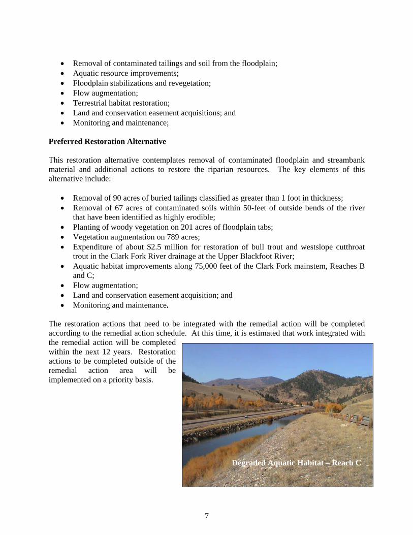
Restoration Project Area The restoration project area for the CFR Restoration Plan includes the mainstem of Clark Fork River from Warm Springs Ponds to Milltown Reservoir and associated riparian zone and the upper Blackfoot River. The upper Blackfoot River is included to specifically restore bull trout and westslope cutthroat trout and their habitat. Opportunities to restore bull trout in the Upper Clark Fork River Basin above Rock Creek are considered low due to residual mining and other human-imposed impacts. Consequently, the State proposes to augment the future remedial and restoration actions to be implemented at the upper Blackfoot River near the Mike Horse mine using a limited amount ($2.5 million) of the damages recovered under the 2008 settlement. Key Restoration Points There are four restoration alternatives included in the restoration plan, each of which would cost about $27 million, the amount provided for in the CFR portion of the NRD settlement. The State assumed integration of the restoration actions with the remedial actions to reduce costs. There is also an assumption of landowner cooperation. The State identified seven types of restoration actions that would help reestablish the natural processes and meet the goals and objectives of the Plan. These actions, which are listed below, were the foundation for development of the four restoration alternatives presented in the Plan.
6
• Removal of contaminated tailings and soil from the floodplain; • Aquatic resource improvements; • Floodplain stabilizations and revegetation; • Flow augmentation; • Terrestrial habitat restoration; • Land and conservation easement acquisitions; and • Monitoring and maintenance;
Preferred Restoration Alternative This restoration alternative contemplates removal of contaminated floodplain and streambank material and additional actions to restore the riparian resources. The key elements of this alternative include:
• Removal of 90 acres of buried tailings classified as greater than 1 foot in thickness; • Removal of 67 acres of contaminated soils within 50-feet of outside bends of the river
that have been identified as highly erodible; • Planting of woody vegetation on 201 acres of floodplain tabs; • Vegetation augmentation on 789 acres; • Expenditure of about $2.5 million for restoration of bull trout and westslope cutthroat
trout in the Clark Fork River drainage at the Upper Blackfoot River; • Aquatic habitat improvements along 75,000 feet of the Clark Fork mainstem, Reaches B
and C; • Flow augmentation; • Land and conservation easement acquisition; and • Monitoring and maintenance.
The restoration actions that need to be integrated with the remedial action will be completed according to the remedial action schedule. At this time, it is estimated that work integrated with the remedial action will be completed within the next 12 years. Restoration actions to be completed outside of the remedial action area will be implemented on a priority basis.
Degraded Aquatic Habitat – Reach C
7
Montana’s Draft Conceptual Smelter Hill Area Uplands Resources Restoration Plan
The State of Montana’s December 2007 draft restoration plan for the Smelter Hill Area Uplands takes into account the 2008 settlement with ARCO, including the $13.3 million in natural resource damages the State will receive for restoration at the Smelter Hill Area Uplands site if the settlement is approved by the court. Smelter Hill Area Upland Site Background and Injury Overview Emissions from the Anaconda Smelter stack resulted in the deposition of hazardous substances, including copper, arsenic, cadmium and zinc, across hundreds of square miles of surface soils
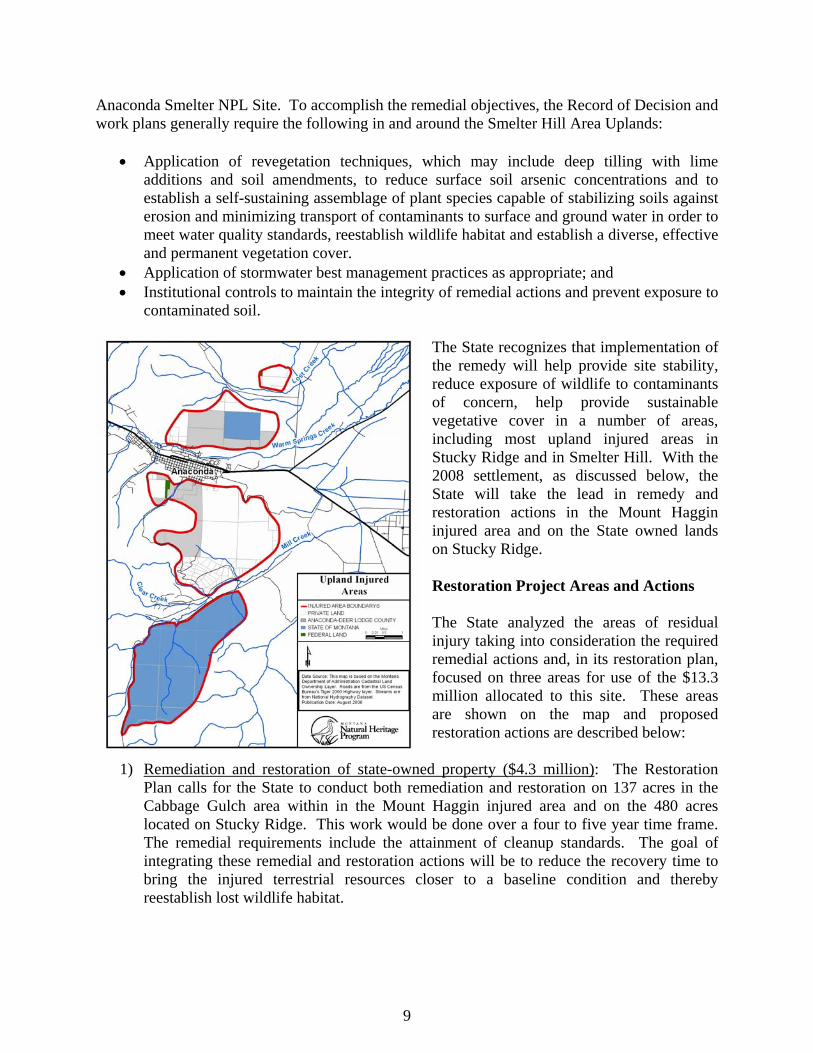
surrounding and downwind of the stack. This resulted in injury to soils, vegetation, wildlife habitat, and wildlife. In its natural resource injury assessment, the State defined injured resource areas as those areas which exhibit complete or virtual elimination of major indigenous plant associations, little or no regeneration of major indigenous plant associations, and extensive topsoil exposure and erosion due to vegetation loss. Upland areas which meet this injury criteria extend across approximately 17.8 square miles (11,350
acres) of land (see map). The injured area encompasses the eastern portion of Stucky Ridge, areas to the west and south of Smelter Hill and portions of the Mount Haggin Wildlife Management Area east of the Mill Creek Highway. Soils in the injured area have elevated concentrations of hazardous substances which prevent vegetation establishment. In general, across these injured areas, there has been a shift in plant community types from coniferous forests and grassland to areas of sparse cover consisting of noxious weeds and some grasses or bare ground. The elimination of upland vegetation communities in the injured areas has caused a severe disruption to the ecosystem. Most notable has been the drastic reduction in the quantity and quality of wildlife habitat. Remediation The 1998 Record of Decision for the Anaconda Regional Water, Waste, and Soils Operable Unit, as well as the related work plans and design reports, set forth the remedial actions and performance standards for the
Smelter Hill and Stack
8
Anaconda Smelter NPL Site. To accomplish the remedial objectives, the Record of Decision and work plans generally require the following in and around the Smelter Hill Area Uplands:
• Application of revegetation techniques, which may include deep tilling with lime additions and soil amendments, to reduce surface soil arsenic concentrations and to establish a self-sustaining assemblage of plant species capable of stabilizing soils against erosion and minimizing transport of contaminants to surface and ground water in order to meet water quality standards, reestablish wildlife habitat and establish a diverse, effective and permanent vegetation cover.
• Application of stormwater best management practices as appropriate; and • Institutional controls to maintain the integrity of remedial actions and prevent exposure to
contaminated soil. The State recognizes that implementation of the remedy will help provide site stability, reduce exposure of wildlife to contaminants of concern, help provide sustainable vegetative cover in a number of areas, including most upland injured areas in Stucky Ridge and in Smelter Hill. With the 2008 settlement, as discussed below, the State will take the lead in remedy and restoration actions in the Mount Haggin injured area and on the State owned lands on Stucky Ridge.
ed below:
Restoration Project Areas and Actions The State analyzed the areas of residual injury taking into consideration the required remedial actions and, in its restoration plan, focused on three areas for use of the $13.3 million allocated to this site. These areas are shown on the map and proposed restoration actions are describ
1) Remediation and restoration of state-owned property ($4.3 million): The Restoration Plan calls for the State to conduct both remediation and restoration on 137 acres in the Cabbage Gulch area within in the Mount Haggin injured area and on the 480 acres located on Stucky Ridge. This work would be done over a four to five year time frame. The remedial requirements include the attainment of cleanup standards. The goal of integrating these remedial and restoration actions will be to reduce the recovery time to bring the injured terrestrial resources closer to a baseline condition and thereby reestablish lost wildlife habitat.
9
The combined restoration/remediation on the 137 acres in Cabbage Gulch will involve: • Tree planting and liming on 112 acres of steep slope areas; • Dozer basins on 18 acres; • Tillage and fertilization on 25 acres; • Seeding, weed controls and aerial fertilization on 137 acres; and • Best management practices and sediment retention basins as needed.
The combined restoration/remediation on the 480 acres on Stucky Ridge will involve: • Tillage to 12 inches on 335 acres and lime application; • Seeding and fertilization on 445 acres; • Tree/shrub plantings on 267 acres; • Dozer basins on 50 acres; • Best management practice and weed controls; • Liming on an additional 90 acres of steep sloped areas; and • Stripping and grading on part of the tillage areas.
2) Restoration of other state-owned lands in the Mount Haggin area ($5 million): The State will restore 850 acres of bare and degraded areas identified in the restoration plan within the 4,300 acre Mount Haggin injured area that lack vegetation, soil organisms, and soil organic matter that provide nutrients and moisture retention. The goal of these restoration actions is to reduce the recovery time to bring the injured terrestrial resources closer to a baseline condition and thereby reestablishing lost wildlife habitat.
Key restoration actions to be completed over four to five years on much of these 850 acres will involve:
• Lime addition, weed controls; • Tree and shrub planting and
establishment on most of the area; and
• Aerial fertilization and seeding.
Stucky Ridge
3) County-owned lands ($4 million): Additional restoration will be implemented on land
owned by Anaconda/Deer Lodge County within the Uplands injured areas. Restoration actions will be coordinated with remedial actions within these areas. The scope of this additional restoration will be determined at a later date, although it is presently expected that such restoration will be based, at least in part, on the actions previously proposed for these areas described in previous versions of the restoration plan for this site. The restoration plan may be amended to provide for specific additional restoration actions on County-owned lands after consideration of further input by the County and the public as to what particular actions should be implemented. The goal of these actions will be to restore, rehabilitate, replace or acquire the equivalent of the injured terrestrial resources on the County-owned lands.
10
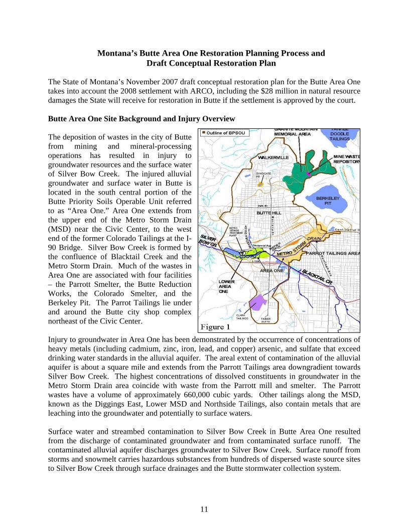
Montana’s Butte Area One Restoration Planning Process and Draft Conceptual Restoration Plan
The State of Montana’s November 2007 draft conceptual restoration plan for the Butte Area One takes into account the 2008 settlement with ARCO, including the $28 million in natural resource damages the State will receive for restoration in Butte if the settlement is approved by the court. Butte Area One Site Background and Injury Overview The deposition of wastes in the city of Butte from mining and mineral-processing operations has resulted in injury to groundwater resources and the surface water of Silver Bow Creek. The injured alluvial groundwater and surface water in Butte is located in the south central portion of the Butte Priority Soils Operable Unit referred to as “Area One.” Area One extends from the upper end of the Metro Storm Drain (MSD) near the Civic Center, to the west end of the former Colorado Tailings at the I-90 Bridge. Silver Bow Creek is formed by the confluence of Blacktail Creek and the Metro Storm Drain. Much of the wastes in Area One are associated with four facilities – the Parrott Smelter, the Butte Reduction Works, the Colorado Smelter, and the Berkeley Pit. The Parrot Tailings lie under and around the Butte city shop complex northeast of the Civic Center. Injury to groundwater in Area One has been demonstrated by the occurrence of concentrations of heavy metals (including cadmium, zinc, iron, lead, and copper) arsenic, and sulfate that exceed drinking water standards in the alluvial aquifer. The areal extent of contamination of the alluvial aquifer is about a square mile and extends from the Parrott Tailings area downgradient towards Silver Bow Creek. The highest concentrations of dissolved constituents in groundwater in the Metro Storm Drain area coincide with waste from the Parrott mill and smelter. The Parrott wastes have a volume of approximately 660,000 cubic yards. Other tailings along the MSD, known as the Diggings East, Lower MSD and Northside Tailings, also contain metals that are leaching into the groundwater and potentially to surface waters. Surface water and streambed contamination to Silver Bow Creek in Butte Area One resulted from the discharge of contaminated groundwater and from contaminated surface runoff. The contaminated alluvial aquifer discharges groundwater to Silver Bow Creek. Surface runoff from storms and snowmelt carries hazardous substances from hundreds of dispersed waste source sites to Silver Bow Creek through surface drainages and the Butte stormwater collection system.
11
Parrot Smelter – 1890 Remediation The following remedial actions, among many other actions, will be implemented at the Butte Priority Soils Operable Unit site based on the U.S. Environmental Protection Agency’s 2006 Record of Decision for the site. These actions are expected to substantially reduce impacts to Silver Bow Creek from hazardous substances:
• Collection of contaminated groundwater throughout the western portion of Area One will continue and be improved, and the water is routed to the existing treatment lagoons for treatment. A conventional lime treatment facility will be built if these lagoons prove inadequate in treating contaminated groundwater.
• Implementation of a storm water management program to prevent contaminated storm water runoff from harming surface water quality in Silver Bow Creek. Source controls such as routing of storm flows and maintaining soil covers on the 450 acres of previously reclaimed areas will be implemented. Also, storm/sewer replacement of 40 miles of pipes is planned. If these controls are not effective in achieving adequate surface water quality in Silver Bow Creek, then storm water will be treated with lime to remove contaminants. Contaminated sediments along Blacktail and Silver Bow Creeks will be removed. Monitoring of groundwater and surface water will occur for the next century.
• Replacement of contaminated soils (with elevated lead and arsenic levels) in approximately 1300 residential yards over a 14 year period.
Also, over the last two decades, approximately $60 million has been spent on numerous response actions directed by EPA, including removal of the Colorado Tailings, construction of soil caps on 420 acres of mine waste areas, and removal of contaminated soils in the Metro Storm Drain, railroad beds and residential yards.
Butte Area One
12
Residual Groundwater and Aquatic Injury The Parrott Tailings will remain in the Upper Metro Storm Drain area following remedial actions, together with other tailings along the MSD. These tailings will continue to release hazardous to groundwater in this area for many centuries, if not thousands of years. The State views the Parrott Tailings as being the most significant source of contaminations to the alluvial aquifer in the Metro Storm Drain area; however, lower Metro Storm Drain tailings will also be a continuing source of contamination to ground and surface waters. Restoration Planning Process and Draft Conceptual Restoration Plan The State’s draft restoration plan for Butte Area One is conceptual in nature and sets forth a restoration planning process to determine how the $28 million settlement, plus the interest that is earned thereon, will be expended to restore or replace the injured resources. Under this process:
• A final restoration plan will be developed based, in large part, on local input. This plan would allocate the entire $28 million, plus interest, for Butte restoration projects;
• A Butte “NRD Restoration Council” would be created for purposes of developing the final restoration plan;
• Restoration planning is expected to be a one to two year process; • The Governor, as trustee of the settlement money, would approve the final restoration
plan; • By law, settlement money may only be spent on projects that restore, replace, or acquire
the equivalent of injured natural resources or lost services. The conceptual restoration plan presents alternatives that involve two types of restoration actions. Some actions are centered on direct restoration of resources by removing or mitigating wastes that are injuring groundwater and surface water resources in order to restore groundwater resources (actions 1-3 below). Other proposed actions address injuries at Area One with resource replacement type projects (actions 3-6 below). The various proposed restoration actions and estimated costs are:
1) Excavate and remove an estimated 666,000 cubic yards at the Parrott Tailings area; removal and reconstruction of the City-County vehicle shop would be necessary to access tailings ($20 million).
2) Excavate and remove all accessible tailings at Lower Area One and Lower Metro Storm Drain, estimated at 162,000 cubic yards ($6 million).
3) Place 12 inches of soil on approximately 35 acres of previously reclaimed waste sites and 60 acres of unreclaimed waste areas ($4 million).
4) Fund of one-third of the money needed for a water treatment plant for the Basin Creek Reservoir Butte drinking water source ($5 million).
5) Rehabilitate the diversion dam at the Big Hole Pump Station ($3.7 million). 6) Replace about one-half of the Big Hole 36-inch Transmission Main ($15 million).
The State developed three restoration alternatives based on the actions listed above. The cost of each of the three alternatives is approximately $28 million. One alternative focuses on the first
13
three actions, listed above, and one alternative focuses on the last three actions. The other alternative involves a combination of replacement and direct restoration components. As outlined above, a final restoration alternative costing about $28 million will be developed through local input.
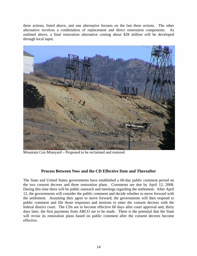
Mountain Con Mineyard – Proposed to be reclaimed and restored
Process Between Now and the CD Effective Date and Thereafter The State and United States governments have established a 60-day public comment period on the two consent decrees and three restoration plans. Comments are due by April 12, 2008. During this time there will be public outreach and meetings regarding the settlement. After April 12, the governments will consider the public comment and decide whether to move forward with the settlement. Assuming they agree to move forward, the governments will then respond to public comment and file those responses and motions to enter the consent decrees with the federal district court. The CDs are to become effective 60 days after court approval and, thirty days later, the first payments from ARCO are to be made. There is the potential that the State will revise its restoration plans based on public comment after the consent decrees become effective.
14
15
The State of Montana will receive comments on or relating to the proposed consent decrees and the three restoration plans until April 12, 2008. Comments should be addressed to: Montana Natural Resource Damage Program, Montana Department of Justice P.O. Box 201425, Helena, MT 59620-1425 The comments may be mailed to the above address or they may be emailed to the State of Montana at [email protected]. Copies of the proposed consent decrees and restoration plans may be reviewed and examined at the following locations: Hearst Free Library 4th and Main Street Anaconda, MT 59711 Phone: 406-563-6932 EPA Butte Office 155 West Granite Butte, MT 59701 Phone: 406-782-3838 Missoula City/County Library 301 East Main Street Missoula, MT 59802 Phone: 406-721-2665
Grant-Kohrs Ranch 266 Warren Lane Deer Lodge, MT 59722 Phone: 406-846-2070 Montana Tech 1300 West Park Butte, MT 59701 Phone: 406-496-4281 Mansfield Library University of Montana Missoula, MT 59812 Phone: 406-243-6860
EPA Records Center 10 West 15th Street Helena, MT 59626 406-457-5046 Powell County Planning Office 409 Missouri Street Deer Lodge, MT 59722 Phone: 406-846-3680 Natural Resource Damage Program 1301 East Lockey Helena, MT 59601 406-444-0205
The proposed consent decrees and restoration plans are also available for review on the following internet sites: http://doj.mt.gov/lands/naturalresource/lawsuithistory.asp http://epa.gov/region8/superfund/mt/milltowncfr/cfr/ Additional information can be found at the DEQ internet site: http://www.deq.mt.gov/FedSuperfund/ClarkFork/ClarkForkRiverOperableUnit.pdf In addition, copies of the consent decrees and the restoration plans are available on compact disk. Please contact Michelle Golden at the Montana Natural Resource Damage Program by telephone at (406) 444-0205 or email her at [email protected], in order to obtain such CDs.