37
Summer 2008 Summer 2008 Foundation continued and Paper 3
| Date post: | 13-Dec-2015 |
| Category: |
Documents |
| Upload: | maud-blair |
| View: | 212 times |
| Download: | 0 times |

Summer 2008Summer 2008
Foundation continued and Paper 3

2
6. Urban Environments: 6. Urban Environments: (a) Study Figure 6 (a) Study Figure 6 which shows part of an MEDC town.which shows part of an MEDC town.
• (i) Give the name for this part of an urban settlement. Underline the correct term:. (1)
• central business district• inner city• rural-urban fringe• (ii) Match the following
terms with the areas around A and B marked on the diagram (1)
• outer suburbs • greenfield land

3
6. Urban Environments: 6. Urban Environments: (a) Study Figure 6 (a) Study Figure 6 which shows part of an MEDC town.which shows part of an MEDC town.
• (iii) What feature separates these two areas? (1)
• (iv) Suggest why the area of greenfield land has not been developed. (2)
• (v) Name two groups of people who are likely to be interested in developing the greenfield land shown. For each group, give a reason for your choice. (6)
• Group 1 Reason • Group 2 Reason • (vi) For one of the groups named
in (v), explain how their development of the land might bring them into conflict with local residents and environmentalists. (4)

4
77. Fragile Environments: a. Fragile Environments: a) Study Figure 7 ) Study Figure 7 which is a map of Burkina Faso showing areas which is a map of Burkina Faso showing areas now experiencing desertification.now experiencing desertification.
• (i) Which area of Burkina Faso is experiencing the severest soil erosion and desertification? Underline North South (1)
• (ii) Which of the two types of river does not flow all the time? Underline
• permanent river• intermittent river(1)

5
77. Fragile Environments:. Fragile Environments:(a) Study Figure 7 (a) Study Figure 7 which is a map of Burkina Faso showing areas which is a map of Burkina Faso showing areas now experiencing desertification.now experiencing desertification.• (i) Which area of
Burkina Faso is experiencing the severest soil erosion and desertification? Underline North South (1)
• (ii) Which of the two types of river does not flow all the time? Underline
• permanent river• intermittent river(1)

6
77. Fragile Environments: . Fragile Environments:
• (iii) With reference to Figure 7, describe the relationship between rainfall and river type. (2)
• (b) (i) What is a drought? (1)
• (ii) Which of the following best describes the terms soil erosion and desertification?: (2) desert-like conditions covering a smaller area little vegetation now covering an area: the washing away or blowing away of soil: the watering of land by people during dry
weather: trees being cut down

7
77. Fragile Environments: . Fragile Environments:
• (iii) Give two reasons why drought makes soil erosion and desertification more likely. (2)
• (c) (i) Suggest two ways in which people contribute to desertification. (2)
• (ii) Outline how desertification affects people.(3)
• (d) Describe the actions taken by people in one or more named areas to slow the rate of desertification. (6)
•See over…

8
Solutions to desertificationSolutions to desertification• In the short-term, provide food aid and water
supplies to prevent suffering.• Improve water supplies by building large
reservoirs and drilling deeper wells.• Conserve water in local small-scale schemes eg
bunds (stone barriers along the contours) in Burkino Faso and zai holes or sand dams (see video on wiki)
• Encourage sustainable farming practices (using locally-made tools, not tractors) – minimum till
• Provide drought-resistant seed such as millet (northern Nigeria). GM crops.
• Tree planting schemes to reduce soil erosion (Mauritania).
• International action to reduce the causes of global warming.

9
Conservation ProjectsConservation Projects• Eden Foundation: Founded 1985 in
Sweden• Niger is one of the driest countries in
the world, situated south of the Sahara desert. The people are poor and have neither money nor water to spare.
• Their solution is to bring trees and bushes that can grow naturally in this dry area and give food, even in times of need.
• There are 250,000 known plant species in the world, but only 20 of them provide 90% of our food so the Eden Foundation grow underexploited, edible trees and bushes to feed the local people.
• Since their arrival, Eden has served more than 2500 households in the region.
• The seeds are free and they show the local people how to grow the seed.
• They also give health advice.

10
Eden FoundationEden Foundation
"Thanks to our Eden trees, we've had food to eat even though the millet failed. For the last three years, we haven't had a single good rain in our village and this year's harvest lasted less than a month. Instead, my family has lived from the Eden fruits on our field which gives us food for the day. We depend on it, for there is nothing else to eat around here."
- Musa Abari from Garin Farara

11
The effects of desertificationThe effects of desertification
• 1. Poverty – half of all the world’s poor live on farms in degraded land. They are forced to use every scrap of land to destruction becasues they have no choice.
• 2. Migration – in Niger most of the men leave to find jobs that will pay them enough to eat. The women and children are left behind.
• 3. Many women in Burkino Faso sell their children into slavery in the cocoa plantations in Nigeria because they believe they will at least get fed there, instead of staring at home. Child labour is illegal in Nigeria

12
Now for the paper 3!Now for the paper 3!
•Qu 1(a) is about reading maps – and includes 6 figure grid references which we have not covered
• (b) is looking at data, completing graphs and looking at trends
• (c) Having been given some additional information, what conclusions can you come to? What else might you have found out to improve the validity of the conclusion?

13
4 Figure Grid References

14
A four figure grid reference points you towards a particular square on a map. On all OS maps these squares represent one square kilometre. All maps will have lines numbered around the edge. These will not always start at zero but will increase both upwards and across the map. (See the example below). A four figure grid reference will point you to the bottom left hand corner of that particular grid square. Follow the red NEXT buttons to see how these work then try the examples given.

15
You are now at the bottom left hand corner of grid square 21 31

16
What grid squares are the letters T in and then after that S ?
See how the grid line numbers are now shown on the map

17
T is in grid square 04 82Along to line 04
Up to line 82
Now we are at the bottom left of square 04 82
And S?(work out
what numbers
have to be!)

18
6 Figure Grid References

19
How to work out 6 figure grid references…
• Let us first look at how the 6 figure grid reference is made up.
• Let us take 216 322 as an example.
• The first 3 figures refer to the easting of the point (or the distance along the map)
• While the second 3 figures refer to the northing of the point (or the distance up the map).

20
Looking at our number 216 322
216 is the Easting.
21 is the grid line and 6 is the number of tenths along towards the next grid line.
322 is the Northing.32 is the grid line and 2 is the number of tenths along towards the next grid line.
Start by working out the basic Easting and Northing as you would for a 4 figure
grid reference using only the first 2 easting values and the first 2 northing values.
Then imagine that grid square divided into tenths.

21
Let us find the 6 figure grid reference for the church on the
map below
The church is in grid square 22 31.
If we imagine that square divided into 10 parts, the church is 2 tenths further east and 2 tenths further north.
So the 6 figure grid reference will be 222 312

22
Now try a few on your own…
What is the 6 figure grid reference for the church?
A 461 325
B 325 460
C 328 460

23
Now try a few on your own…
What is the 6 figure grid reference for Lodge Farm?
A 303 458
B 453 305
C 306 454

24
Now try a few on your own…
What is the 6 figure grid reference for the school?
A 323 465
B 332 456
C 313 465

25
Now try a few on your own…
What is the 6 figure grid reference for the well?
A 463 315
B 316 467
C 313 463

26
Now try a few on your own…
What is at 6 figure grid reference 325 456?
A The Post Office
B Mickelham Hall
C Cowslip Farm

27
1. 1. (a) Some students investigated the use of irrigated land around (a) Some students investigated the use of irrigated land around Lake Naivasha, Kenya. Figure 1(a) is a sketch map of the area Lake Naivasha, Kenya. Figure 1(a) is a sketch map of the area
based on a satellite photographbased on a satellite photograph
• (i) What is the main land use to the south of Lake Naivasha? (1)
• (ii) What is the main land use that occurs in square 1262? (1)

28
1. 1. (a) Some students investigated the use of irrigated land around (a) Some students investigated the use of irrigated land around Lake Naivasha, Kenya. Figure 1(a) is a sketch map of the area Lake Naivasha, Kenya. Figure 1(a) is a sketch map of the area
based on a satellite photographbased on a satellite photograph
• (iii) What natural vegetation is found in square 1160? (1)
• (iv) Give the six figure grid reference for the primary data collection point. (1)
29
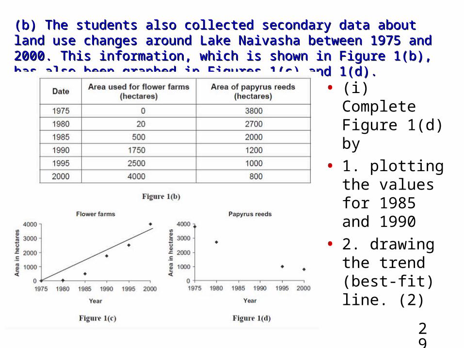
(b) The students also collected secondary data about land use (b) The students also collected secondary data about land use changes around Lake Naivasha between 1975 and 2000. This changes around Lake Naivasha between 1975 and 2000. This information, which is shown in Figure 1(b), has also been graphed information, which is shown in Figure 1(b), has also been graphed in Figures 1(c) and 1(d).in Figures 1(c) and 1(d).
• (i) Complete Figure 1(d) by
• 1. plotting the values for 1985 and 1990
• 2. drawing the trend (best-fit) line. (2)

30
(b) The students also collected secondary data about land use (b) The students also collected secondary data about land use changes around Lake Naivasha between 1975 and 2000. This changes around Lake Naivasha between 1975 and 2000. This information, which is shown in Figure 1(b), has also been graphed information, which is shown in Figure 1(b), has also been graphed in Figures 1(c) and 1(d).in Figures 1(c) and 1(d).
• (ii) Compare the trends shown in Figures 1(c) and 1(d).(2)
• (iii) Suggest a possible link between the two trends you have identified in (ii). (1)
XX

31
(c) The students then asked four people at point A (c) The students then asked four people at point A about the impact that flower-growing is having on Lake about the impact that flower-growing is having on Lake Naivasha and its surroundings. Their views are shown Naivasha and its surroundings. Their views are shown in Figure 1(e).in Figure 1(e).
• (i) What conclusions should the students have reached about the impact of flower-growing on Lake Naivasha and its surroundings? (Use all the resources to help) (6)

32
(c) The students then asked four people at point A (c) The students then asked four people at point A about the impact that flower-growing is having on Lake about the impact that flower-growing is having on Lake Naivasha and its surroundings. Their views are shown Naivasha and its surroundings. Their views are shown in Figure 1(e).in Figure 1(e).
• (ii) What other information might the students have collected to improve the accuracy of their conclusions? (5)

33
2. (a) A student investigated the building of the Jubilee 2. (a) A student investigated the building of the Jubilee River, a flood relief channel, in the United Kingdom. River, a flood relief channel, in the United Kingdom. Study Figure 2(a) which shows the course of the Jubilee Study Figure 2(a) which shows the course of the Jubilee River.River. • (i) Use Figure 2(a) and
the words in the box below to complete the description of the Jubilee River.
•Eton 9 kilometres•River Thames 15
kilometres•Taplow Southeast•Northwest M4 motorway
•12 kilometres•The Jubilee River flows in
a ……………………………….direction from Maidenhead to where it rejoins the River Thames near ....................................... . The Jubilee River is approximately ....................................... long. (3)

34
•(ii) The student annotated a second map, Figure 2(b), giving some of the benefits, costs and disadvantages of building the Jubilee River. Add the following statements in the correct places on the map:
•• noise and dust were produced during building works
•• footpaths and places for fishing were provided. (2)
(iii) What conclusions do you reach when you compare the benefits with the costs and disadvantages of building the Jubilee River? (5)

35
((b) The student then investigated how effective the b) The student then investigated how effective the Jubilee River had been during a major flood. Figure 2(c) Jubilee River had been during a major flood. Figure 2(c) is a newspaper cutting about that flood which the is a newspaper cutting about that flood which the student used as secondary data.student used as secondary data.• The Thames Echo 14th March 2003• The Environment Agency is compiling a report after major
flooding along the River Thames in January 2003. This follows concern from people living in Datchet and Wraysbury that a major new flood relief channel, called the Jubilee River, has moved the flood problem from Windsor and Maidenhead to their homes. A representative from the Environmental Agency said, “The Datchet and Wraysbury region has a long history of flooding and we expected the areas near the River Thames to flood following the very high rainfall in December 2002 and January 2003.”
• However, Mr. Smith, whose home was badly damaged during the flooding, said, “I have lived in Datchet for 30 years and the flooding has never been so bad. The Jubilee River flows back into the River Thames upstream from our homes. This means that the River Thames becomes too full and floods
• (i) Suggest possible reasons for the flooding at Datchet and Wraysbury. (2)

36
c) The student also asked people in two different locations for their c) The student also asked people in two different locations for their views on the Jubilee River. One group was questioned in the views on the Jubilee River. One group was questioned in the central business district of Maidenhead; the other group in the central business district of Maidenhead; the other group in the flood-prone area of Wraysbury. Figure 2(d) shows the results of flood-prone area of Wraysbury. Figure 2(d) shows the results of
that questioning. Figure 2(e) graphs most of the resultsthat questioning. Figure 2(e) graphs most of the results
•Off to the whiteboard it did not fit on here!
• (i) Complete Figure 2(e) by plotting the replies to Question 3 in Wraysbury (2)
• (ii) What are the main features shown in Figure 2(d) and the completed Figure 2(e) (6)

37
• 3. Use your own experience of ONE fieldwork investigation to answer this question.
• (a) What were the main aims of your fieldwork investigation? (2)
• (b) (i) What data did you collect in order to achieve those aims? (4)
• (ii) Describe the sampling methods you used when collecting this data.(4)
• (iii) Why did you choose those sampling methods? (2)
• (c) (i) Identify two presentational techniques you used. Explain why you used those techniques. (You may include diagrams as part of your answer) (6)
• Technique 1 • Technique 2 • (ii) How might you have improved your data
presentation? (2)


