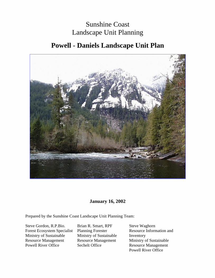
Sunshine Coast Landscape Unit Planning Powell - Daniels Landscape Unit Plan January 16, 2002 Prepared by the Sunshine Coast Landscape Unit Planning Team: Steve Gordon, R.P.Bio. Forest Ecosystem Specialist Ministry of Sustainable Resource Management Powell River Office Brian R. Smart, RPF Planning Forester Ministry of Sustainable Resource Management Sechelt Office Steve Waghorn Resource Information and Inventory Ministry of Sustainable Resource Management Powell River Office
Transcript
Sunshine CoastLandscape Unit Planning
Powell - Daniels Landscape Unit Plan
January 16, 2002
Prepared by the Sunshine Coast Landscape Unit Planning Team:
Steve Gordon, R.P.Bio.Forest Ecosystem SpecialistMinistry of SustainableResource ManagementPowell River Office
Brian R. Smart, RPFPlanning ForesterMinistry of SustainableResource ManagementSechelt Office
Steve WaghornResource Information andInventoryMinistry of SustainableResource ManagementPowell River Office
Powell - Daniels LU Plan 2
Powell - Daniels Landscape Unit PlanTable of Contents
Legal Objectives for the Powell – Daniels Landscape Unit 3
1.0 Introduction 4
2.0 Landscape Unit Objectives 5
3.0 Biodiversity Management Goals and Strategies 7
Appendix II: Landscape Unit Ranking and Biodiversity Emphasis Option Assignment 20
Appendix III: Wildlife Tree Retention Report 21
Appendix IV: Significant Ecological Features in the Powell - Daniels LU 22
Appendix V: Public Consultation Summary 26
Appendix VI: OGMA Polygon Breakdown 27
Powell - Daniels LU Plan 3
Legal Objectives for the Powell - Daniels Landscape Unit
Pursuant to section 4 of the Forest Practices Code of B.C. Act, the following are Landscape Unitobjectives for the Powell - Daniels Landscape Unit.
Objective 1
Maintain or recruit old growth ecosystem values, in old growth management areas, that areestablished as shown on the attached map dated January 16, 2002. No timber harvesting,including salvage and single-tree harvesting, is to occur within old growth management areas.Road construction is not to occur within old growth management areas unless no otherpracticable options exist, in which case replacement old growth management areas may berequired.
Objective 2
Maintain structural diversity within managed stands by retaining wildlife trees within the totalarea under prescription of each cut-block as described below and indicated in the table below:
• Wildlife tree patches are to include a component of the upper 10% of the diameter range oftrees within the stand to be harvested.
• No harvesting, including salvage or single-tree removal, is to occur within establishedWildlife Tree Patches.
Wildlife Tree Retention by Biogeoclimatic Ecosystem Classification Subzone
BEC Subzone Total WTR (%)CWHdm 11CWHvm 10MHmm 4
CWHdm: Coastal Western Hemlock biogeoclimatic zone, dry maritime subzoneCWHvm Coastal Western Hemlock biogeoclimatic zone, very wet maritime zoneMHmm: Mountain Hemlock biogeoclimatic zone, moist maritime subzone
WTR = Wildlife Tree RetentionBEC = Biogeoclimatic Ecosystem Classification
Note: WTR is calculated at the subzone level, thus the CWHvm1 and CHWvm2 variants are combined.
Powell - Daniels LU Plan 4
Sunshine Coast Forest District Landscape Unit PlanningLandscape Unit Plan – Powell - Daniels, 211
January 25, 2002
1.0 Introduction
The Powell - Daniels Landscape Unit (LU) lies within the Pacific Ranges Ecoregion, Southernand Northern Pacific Ranges ecosection. Lower elevation, productive and gentle-terrain siteshave been disturbed by past forest harvesting, fire and other factors. Relatively low levels of oldseral forest representation within the Powell - Daniels low elevation biogeoclimatic zonesreflects this disturbance history. Despite an extensive harvest history, large amounts ofinaccessible or constrained areas enable the Powell - Daniels LU to meet levels of old growthrepresentation recommended by the Landscape Unit Planning Guide.
The Powell - Daniels LU is entirely within Tree Farm License 39, administered byWeyerhaeuser Company Ltd. As the entire LU is within TFL 39, the TFL database was used tocalculate all old growth targets by BEC unit. Weyerhaeuser Company Ltd. staff were directlyinvolved through all phases of preparation of the Landscape Unit plan.
The Powell - Daniels LU contains a wide range of significant natural resource values andfeatures including complex river floodplains, wetland complexes, massive rock bluffs, alpinemeadows, avalanche tracks, and active glaciers. Ecosystem complexity is moderate in this LU.Situated at the head of Powell Lake, the Powell - Daniels LU is quite remote, though limitedbackcountry recreation activity, including rock-climbing and mountaineering, occurs in this area.
Four species of Identified Wildlife are present within the Powell - Daniels LU: the marbledmurrelet (MAMU), mountain goat, grizzly bear, and the northern goshawk. As outlined in theIdentified Wildlife Management Strategy (IWMS) the MAMU is to be managed through theplacement of Old Growth Management Areas (OGMAs) within suitable MAMU habitat. Thishas been done in the Powell - Daniels LU, although limited amounts of non-contributing forest inthe area have resulted in several large tracts of contiguous old growth forest not being capturedin OGMA. Portions of several candidate MAMU habitat areas have been included in OGMAs inthis LU plan. OGMAs established under this plan are also expected to overlap with suitablenorthern goshawk nesting habitat.
Both the Powell and Daniels Rivers are relatively low productivity due to high seasonal run offand low levels of instream nutrients. Both systems support populations of resident trout and char,however, they do not support anadromous salmon species.
Mountain goat winter range habitat has been identified throughout the Powell - Daniels LU.OGMAs have been placed within areas constrained by this resource value where suitable.OGMAs have also been placed to maximize overlap with other high value wildlife habitats suchas riparian areas where appropriate.
The Powell – Daniels LU supports significant populations of both grizzly and black bears.Through the TFL 39 Management Planning process, several areas have been identified asEnvironmentally Sensitive Areas (ESA) for grizzly bear; these areas have been included in
Powell - Daniels LU Plan 5
OGMA where suitable old growth structures are present. Seasonal black bear habitat has alsobeen captured in OGMAs in this Landscape Unit, though OGMAs were not specifically set asidefor this species.
The distribution of OGMAs will have to be reviewed periodically. Wildfires and other naturaldisturbance may occur within OGMAs with varying effects on their effectiveness in providingappropriate biodiversity attributes. Each instance will have to be considered separately. In manycases old seral forest may be suited for biodiversity following a fire with its high density of largesnags. Some specific old seral habitat features may be lost due to natural disturbances, andperiodic revision of OGMAs may be required.
2.0 Landscape Unit Objectives
The Powell - Daniels LU received an “intermediate” Biodiversity Emphasis Option (BEO)through the biodiversity value ranking and the BEO assignment processes (see Appendices I, II& IV). Table 1, below, lists the percentages of the LU’s productive forest area per naturaldisturbance type (NDT) designated for old seral representation as OGMA. The percentages ofcutblock area required as Wildlife Tree Patches (WTP) for each of the LU’s biogeoclimaticecological classification (BEC) units are also listed. The target figures listed in Table 1 are fromthe Landscape Unit Planning Guide (LUPG), Appendices 2 and 3.
Note: Objectives apply only to Provincial forest lands within the LU.
TABLE 1: Required Levels for Old Seral Representation and Wildlife Tree Patches.
BEC Unitand NDT
BECVariant
ProductiveForest
LUPG Old SeralRepresentation Target2
OGMA ObjectiveProvincial Forest3
WTP Objective4
(% of cutblockarea)
% Ha % Ha Table A3.1CWHdm(NDT 2)
790.8 9 71.2 8.7 68.8 11
CWHvm1(NDT 1)
5769.8 13 750.1 12.5 726.6 10
CWHvm2(NDT 1)
3732.2 13 485.2 13.2 494.1 10
MHmm1(NDT 1)*
1252.0 19 237.9 20.3 254.2 4
Totals 11544.9 1544.3 1543.7Note: OGMA Figures based on TFL 39 Arc Info database calculations.
1 NDT = Natural Disturbance Type. Refer to LUPG, Appendix 2.2 % of total productive forest area within BEC unit, as per LUPG.3 % of total productive forest area within BEC unit, as per LUPG, minus contributions from old seral representation within protected areas and Crown forest outside of Provincial forest.4 WTP Objectives as per the LUPG, Appendix 3. Table A3.1 applies upon the designation of the Landscape Unit and itsobjectives.CWHdm: Coastal Western Hemlock biogeoclimatic zone, southern dry maritime subzoneCWHvm1: Coastal Western Hemlock biogeoclimatic zone, submontane very wet maritime variantCWHvm2: Coastal Western Hemlock biogeoclimatic zone, montane very wet maritime variantMHmm1: Mountain Hemlock biogeoclimatic zone, windward moist maritime variant. Note: A total of 17.5 ha of forested standsmisclassified as ATp have been included in the MHmm1 OGMA totals.
Powell - Daniels LU Plan 6
OGMA Objectives listed in Table 1 have been met through the delineation of OGMAsthroughout the Powell - Daniels LU. Refer to OGMA map for their location, and to Table 3,below, for a breakdown of OGMA non-contributing (NC), constrained Timber HarvestingLandbase (THLB) and unconstrained THLB components.
A detailed breakdown of the OGMA stand attributes is provided in Appendix VI.
TABLE 2: Wildlife Tree Retention (WTR) by Biogeoclimatic Ecosystem ClassificationSubzone
BEC Subzone Total WTR (%)CWHdm 11CWHvm 10MHmm1 4
WTP retention targets are calculated at the subzone level, thus the targets for both the CWHvm1 and CWHvm2variants are the same.
As per the Biodiversity Guidebook, 75% of WTR requirements are assumed to be met throughotherwise constrained areas such as riparian reserves.
TABLE 3: Non - Contributing, Constrained THLB and Unconstrained THLB Components of Powell - Daniels LU OGMAs:
1 Total Old Seral Representation from Table 1, above.2 Non - Contributing Area in OGMA = forest land that does not contribute to the AAC, subject to 100% netdown3 Partially contributing THLB in OGMA = Timber Harvesting Land Base that cannot fully contribute to the AAC due to sitesensitivity or the need to manage for other resource values4 Forests contributing to the AAC calculation, otherwise unconstrained
During OGMA placement, efforts were made to maximize overlap with constrained areaswherever appropriate. No existing proposed or approved cutblocks were affected by OGMAplacement. Some OGMAs were placed in contributing and partially contributing areas, as harvesthistory precluded achieving targets entirely in the non-contributing landbase in some areas.
The establishment of an OGMA will not have an impact on the status of existing mineral and gaspermits or tenures. Exploration and development activities are permitted in OGMAs. The
Powell - Daniels LU Plan 7
preference is to proceed with exploration and development in a way that is sensitive to the oldgrowth values of the OGMA; however, if exploration and development proceeds to the point ofsignificantly impacting old growth values, then the OGMA will be moved.
3.0 Biodiversity Management Goals and Strategies
3.1 General Management Goals
Biodiversity management goals and strategies describe, in specific terms, the outcomes that theLU Objectives are to achieve. They also describe the rationale for the selection of OGMAs,some of the ecological features that OGMAs are to include, and some of the compromises madeto balance the management of all values present in the LU. While Objectives are legally binding,management goals and strategies are not. The biodiversity ranking process identified manysignificant biodiversity values within the Powell - Daniels LU that must be managed for. Thedelineation of OGMAs cannot be undertaken without recognition of these significant valuesbecause OGMA delineation is the most effective provision of the Forest Practices Code (FPC)LU planning initiative for managing biodiversity. Refer to Appendix IV for detailed descriptionof Powell - Daniels LU values considered in the LU planning process.
The development of biodiversity management goals and strategies is important not only for theconservation of biodiversity, but also to allow the development of strategies to mitigate short andlong-term LU planning impacts on timber supply. For example, OGMA delineation was notguided strictly by age class or AAC contributions, as this approach could result in the inclusionof stands of marginal biodiversity value and significant timber supply impact within OGMAs.Individual forested polygons were assessed according to their specific attributes during theOGMA delineation process.
In the Powell - Daniels LU, maintenance of high value bear habitats is a key management goal;the Powell - Daniels LU supports regionally significant grizzly and black bear populations.Efforts were made to include forested stands adjacent to high value feeding sites within OGMAswherever possible to maximize overlap between old growth representation and specific wildlifehabitat requirements. Areas previously identified as Environmentally Sensitive Areas for wildlifewere included in OGMAs where they provided mature or old forest representation or includedunder-represented ecosystem types. As a result, some mature stands not classified as “oldgrowth” have been included in OGMAs to reflect operational constraints related to wildlifemanagement.
The maintenance of marbled murrelet habitat within the Powell - Daniels LU is also of concern.As per the guidance of the LUPG, OGMAs were established first in areas considered as “non-contributing” forest in the current Timber Supply Review. Limited amounts of large tracts ofnon-contributing old growth exist in the Powell – Daniels LU. Current policy requires OGMAsto be delineated within the non-contributing land base. During OGMA delineation, efforts weremade to include as much candidate MAMU habitat in OGMA as possible, though harvestingactivity within or adjacent to these areas has reduced total patch size and may affect marbledmurrelet nesting habitat suitability. Further research will be required to determine if MAMUhabitat requirements have been adequately addressed through the OGMA delineation process.OGMA revisions may be required if further analysis indicates MAMU nesting activity does not
Powell - Daniels LU Plan 8
significantly overlap OGMAs, to both mitigate timber supply impacts and maximize the efficacyof OGMAs for protection of MAMU habitat.
Mountain goats occur in small herds throughout the Powell - Daniels LU. Where suitable oldgrowth stands exist within Ungulate Winter Range (UWR) habitats, these were included inOGMAs to maximize overlap between OGMA delineation and specific wildlife habitatrequirements. As UWR habitats are typically rocky, southerly aspect sites, not all old growthstands within UWR areas have been included to ensure biodiversity representation was notconcentrated in a particular stand type.
Efforts were also made during preparation of this LU plan to ensure OGMAs were distributedthroughout the LU and not concentrated in a particular drainage or mapsheet. This is in keepingwith the “coarse filter” approach of biodiversity management whereby representative old growthstands are protected in order to maintain ecosystem processes and specific wildlife habitatrequirements, which may be poorly understood.
In all cases, detailed air photo review was performed to confirm the forest cover attributes andsuitability of a given stand for OGMA inclusion. Numerous stands have been field checked toverify the presence of desirable old seral characteristics.
3.2.1 CWHdm Biodiversity Management Goals
1. Maintain old seral representation, to the CWHdm objective of 8.7 %, or 68.5 ha withinProvincial forest through delineation of old growth management areas (OGMAs) as per theattached maps. No harvesting activities, including salvage or single-tree harvesting, are tooccur within OGMAs.
2. Maintain areas that are representative of natural CWHdm ecosystem patterns and ecosystemmosaics.
3. Include rare or unique stands (such as Ss leading or pure Fd stands) within OGMAs whereverpossible.
4. Place OGMAs where site location and topographic features provide the highest value wildlifehabitat and biodiversity value such as the confluence’s of creek systems and adjacent to slidetracks, wetlands or other features where compatible with old growth representation issues.
5. Include mature ESAs for wildlife within OGMA where compatible with biodiversityobjectives.
3.2.2 CWHdm Biodiversity Management Strategies
A. Delineate OGMAs to include existing stands of old growth or particularly high biodiversityvalue mature stands that will provide old growth characteristics in as short a time frame aspossible. (Goals 1, 2)
B. Include unique and constrained areas within OGMA. (Goals 1, 2, 3)
Powell - Daniels LU Plan 9
C. Retain veterans within harvesting areas (Fd as well as Cw, Hw) to levels typical of densitiesfound following natural disturbances as a focus of stand level biodiversity management (Goal2)
3.3.1 CWHvm1 Biodiversity Management Goals
1. Meet the objective of 13.1 % or 753.2 ha old growth retention in Provincial forest throughdelineation of OGMAs in existing old growth stands as shown on the attached map. Noharvesting, including salvage or single-tree harvesting, is to occur within OGMAs.
2. Maintain areas that are representative of natural CWHvm1 ecosystem patterns and ecosystemmosaics.
3. Aggregate OGMAs wherever possible and consistent with biodiversity managementobjectives to provide for forest interior conditions within OGMAs.
4. Include unique or spatially significant stands within OGMAs where possible.
5. Maximize overlap between OGMA placement and high value marbled murrelet nestinghabitat where consistent with policy direction and biodiversity considerations.
3.3.2 CWHvm1 Biodiversity Management Strategies
A. Delineate OGMAs to include existing old growth stands (Goal 1)
B. Delineate OGMAs to be as large and contiguous as possible and to contain as wide a range ofsites as possible. (Goals 2, 3, 5)
C. Retain veterans within harvesting areas (Fd as well as CW, Ss, Hw) to levels typical ofdensities found following natural disturbances as a focus of stand level biodiversitymanagement. Retention of dominants as veteran recruits is recommended where veterans arenot present in the stand. (Goals 2, 5)
D. Include unique features and constrained areas within OGMAs where compatible withbiodiversity management. (Goals 4, 6)
3.4.1 CWHvm2 Biodiversity Management Goals
6. Meet the objective of 13.2 % or 492.7 ha old growth retention in Provincial forest throughdelineation of OGMAs in existing old growth stands as shown on the attached map. Noharvesting, including salvage or single-tree harvesting, is to occur within OGMAs.
7. Maintain areas that are representative of natural CWHvm2 ecosystem patterns and ecosystemmosaics.
8. Aggregate OGMAs wherever possible and consistent with biodiversity managementobjectives to provide for forest interior conditions within OGMAs.
Powell - Daniels LU Plan 10
9. Include unique or spatially significant stands within OGMAs where possible.
10. Maximize overlap between OGMA placement and high value marbled murrelet nestinghabitat where consistent with policy direction and biodiversity considerations.
3.4.2 CWHvm2 Biodiversity Management Strategies
B. Delineate OGMAs to include existing old growth stands (Goal 1)
C. Delineate OGMAs to be as large and contiguous as possible and to contain as wide a range ofsites as possible. (Goals 2, 3, 5)
D. Retain veterans within harvesting areas (Fd as well as CW, Ss, Hw) to levels typical ofdensities found following natural disturbances as a focus of stand level biodiversitymanagement. Retention of dominants as veteran recruits is recommended where veterans arenot present in the stand. (Goals 2, 5)
E. Include unique features and constrained areas within OGMAs where compatible withbiodiversity management. (Goals 4, 6)
3.4.1 MHmm1 Biodiversity Management Goals:
1. Achieve the target of 20.3 % or 254.3 ha old growth representation in Provincial forestthrough delineation of OGMAs as per the attached map. No harvesting, including salvage orsingle-tree harvesting, is to occur within OGMAs.
2. Attempt to make OGMAs as large and contiguous as possible to maximize their suitabilityfor MAMU habitat nesting wherever possible and consistent with current policy to includenon-contributing forest stands within OGMA.
3. Include rare or under-represented stand types within OGMAs where possible and compatiblewith biodiversity objectives.
4. Place OGMAs in areas with ecological or topographic features to capture the highest habitatcomplexity possible.
3.4.2 MHmm1 Biodiversity Management Strategies
A. Delineate OGMAs to include as much suitable MAMU habitat as possible. (Goals 1, 2,)
B. Delineate OGMAs to be contiguous with adjacent OGMAs in the CWHvm1. (Goals 2, 4)
C. Include stands in OGMAs with least amount of operable timber and highest MAMU habitatsuitability, where these values are compatible. (Goals 1, 2)
Powell - Daniels LU Plan 11
4.0 Mitigation of Timber Supply Impacts
The Powell - Daniels LU plan has been developed to maximize the effectiveness of the ForestPractices Code’s biodiversity management provisions while minimising impacts on the TFL 39timber supply.
Specific measures adopted to minimize impacts of Powell - Daniels LU planning to the timbersupply include the following:
As the entire Powell – Daniels LU is within TFL 39, the TFL license holder(Weyerhaeuser Forestry Ltd.) was directly involved in OGMA selection. Whereverpossible, attempts were made to locate OGMAs so as to minimize impacts on current orfuture timber harvesting opportunities, while ensuring suitable old growth representationwas achieved.
Wildlife ESAs (as per TFL 39 Management Working Plan Number 8) constrained areas,Ungulate Winter Range (UWR), lower productivity sites, areas of difficult access andmarginal economics were included within OGMAs where possible and where compatiblewith biodiversity objectives.
Old and mature forested stands with high grizzly bear or specific wildlife habitat valueslikely to be constrained operationally were included in OGMAs where compatible withcurrent policy and biodiversity management objectives. This reflects a general principleto maximize overlap between constraints when delineating OGMAs.
Areas to be included in OGMAs were assessed according to MAMU habitat suitability,timber values and existence of road infrastructure for future harvest access. Stands at theperiphery of habitat areas with a high degree of fragmentation were not included inOGMAs due to their lowered habitat suitability and ease of industrial access. Areas withhigh MAMU habitat suitability and a lower degree of habitat fragmentation are generallymore difficult to access and have little existing industrial infrastructure. Inclusion of suchareas in OGMA ensures protection of the most suitable MAMU nesting habitats,minimizes impacts on timber supply through overlap of constraints and allows continueduse of existing roads for future harvesting.
During the LU planning process, careful consideration was made to ensure that timberaccess was not cut off by OGMA delineation. Access corridors were left out of OGMAsand OGMA boundaries were delineated to simplify adjacent management.
The approved 2001 TFL 39 Forest Development Plan and Management Working PlanNumber 8 maps were used during OGMA delineation to avoid proposed or approveddevelopments. The TFL licensee was also consulted directly during OGMA delineation.
OGMA boundaries used natural features wherever possible to ensure they could bereplicated “on the ground”. OGMAs were delineated to include complete stands of timber(forest cover polygons) wherever possible to reduce operational uncertainty and increaseease of OGMA mapping.
Powell - Daniels LU Plan 12
While OGMA placement within the “non-contributing” landbase is consistent with the LUPG,OGMA placement avoided areas in the NC with potential harvest opportunities where OGMAsuitability could be maintained. To ensure the suitability of OGMAs to function as “coarsefilters” for biodiversity management (Biodiversity Guidebook, 1995), areas in the non-contributing landbase with timber otherwise suitable for harvesting for forest harvesting wereincluded in OGMA.
Many non-contributing areas are not included as OGMA at this time, mostly due to their youngage class and absence of old growth characteristics. For example, narrow riparian strips were notincluded as OGMAs due to their inability to fulfil the “coarse filter” function outlined in theBiodiversity Guidebook (1995). Such riparian areas will contribute to meeting wildlife tree patchrequirements for adjacent cutblocks. Periodic assessment and revision of OGMAs may berequired as stand succession proceeds.
Powell - Daniels LU Plan 13
Appendix I: Biodiversity Ranking Process: Ranking Criteria and Criteria Rationale
BEO Ranking Criteria Rationale 98/05/13
Application of the Landscape Unit Ranking Criteria
The three categories of Biodiversity Emphasis Option (BEO) ranking criteria that have beendeveloped for the Sunshine Coast Forest District are to be scored and considered in a separatemanner. The first set of criteria, the ecological values, are to be scored first, determining aninitial BEO ranking for the District's landscape units (LU). In ranking the LUs, the LU with thehighest ecological values score is ranked number one, the next highest, number two. The timbervalues are scored next, with their resultant scores being used as tie-breakers for LUs that havegenerated similar scores through the ecological values criteria. Timber values scores rank in anopposite manner: out of two or more LUs that have similar ecological value scores, the LU withthe lowest timber value score will be ranked highest. Thirdly, the other values criteria arescored, and they are used as tie-breakers for LUs that have scored similarly in both ecologicaland timber values. Higher other values scores rank the LU higher.
The criteria are being applied in a separate, priority manner placing ecological values as the firstpriority because the entire BEO ranking process is designed to determine which LUs havebiodiversity values that most require the additional biodiversity provisions of Higher andIntermediate BEOs. This is consistent with the FPC "Higher Level Plans: Policy andProcedures" October 31, 1996 (HLPPP) Section 5.10.2 Assignment of Biodiversity EmphasisOptions - Chief Forester Direction - Policy, subsection 5, page LU15.
The FPC HLPPP offers two separate directions regarding protected areas and their affects on aLU's BEO ranking and assignment. In Section 5.10.2, page LU14 it states that first, higherBEOs should be assigned to LUs where ecosystems are poorly represented within existingprotected areas, and then, further on it states that higher BEOs should be assigned for LUsadjacent to protected areas. The Sunshine Coast Landscape Unit Planning Team has followedthe first direction because the Sunshine Coast Forest District received somewhat less protectedarea forest ecosystem representation than some other Districts making ecosystem representationa higher priority, and the location of some of the protected areas do not offer easily achievableopportunities for connectivity.
1) Ecological ValuesEcological Values criteria assess which of the District's Landscape Units require higher
levels of biodiversity provisions.
a) LU NDT 2 OG Representation Opportunity (Current state)Landscape Units should rank higher if they have greater amounts of old growth forest
because they have more potential to meet the seral stage requirements of the BiodiversityGuidebook, and have a greater number of biodiversity management options available. Thiscriteria assesses the present amount of old growth, not recruitable areas. Old growthrepresentation is assessed by the remaining percentages of old growth within the NDT2 areas ofthe LUs. NDT1 representation does not need to be considered because of logging history; if
Powell - Daniels LU Plan 14
NDT1 is depleted, NDT2 will be more so. NDT1 is considered where NDT2 makes up less than10% of the LU’s THLB. Percentages used to assign scores for this criteria are based on thepercentages required for old seral stage representation for each BEO in NDT2.
b) Recruitment Potential to Manage for Old GrowthLUs that are underrepresented in old growth may have age class 8 stands that may be
recruited to provide old growth management areas of suitable habitat to meet the old seral stagebiodiversity management requirements. If so, they are better suited to meeting the biodiversityrequirements of a higher-level BEO and should be given a higher ranking. The percentages usedto assign scores for this criteria, as in A above, are based on the percentages required for oldseral stage representation for each BEO in NDT2.
c) Ecosystem Complexitythe greater the number of BEC units within a Landscape Unit, the greater the potential is
that the LU provides habitat for a wider range of species compared to a LU with less BEC units.It is also more likely that a LU with numerous BEC units will be habitat for species that require awider range of habitat. LUs with potential to be habitat for a larger number of species earn ahigher ranking for biodiversity values.
d) Specific Wildlife Habitat RequirementsLUs that contain species that require specific habitat, ecosystems or ecosystem
complexes are likely to require higher levels of habitat provision. LUs with species present thathave been identified as being regionally significant, threatened or endangered may need to havehabitat provided for them out of the operable landbase at higher than minimal levels, so theseLUs will receive higher biodiversity rankings. Higher or Intermediate BEOs provide a greaterrange of habitat management options.
e) Sensitivity to Forest DevelopmentConversion of natural forest stands to even-aged management regimes reduces the range
of habitats available to support an area's natural diversity of species. This reduction in habitat isgreater in NDT 1 which is naturally uneven-aged, than in NDT 2 which is naturally even-aged.The greater the proportion of NDT 1 within a LU, the more the LU requires a higher BEO toprovide habitat management options.
f) ConnectivityIn addition to the presence of Old Growth, its spatial distribution is very important when
assessing the biodiversity management options that remain within a LU. Higher BEO rankingscores will be given under this criteria to those LUs that have old seral stage forest in largecontiguous stands, or in areas where harvesting has not disrupted natural connectivity due tonatural patchy non-contiguous patterns.
g) Complex EcosystemsLUs that contain large floodplains, estuaries, wetlands and herbaceous slidetrack/forest
complexes are inherently habitat to a wider range of species than those LUs that do not. LUsthat contain significant habitat features, in a District-wide context, will receive higher BEOranking scores from this criteria to increase their eligibility to receive a BEO that will provideopportunities for maintenance of appropriate representation and linkages.
Powell - Daniels LU Plan 15
h) Inoperable Land Habitat and Biodiversity RepresentationThis criteria assesses the need for increasing the LU's priority and emphasis for
biodiversity management by determining how much of a LU's biodiversity objectives can be metby default through habitat located in protected and constrained areas.
2) Timber Values CriteriaTimber values criteria assess the relative timber values of the District's Landscape Units
and consider short and long-term contributions of the LU to the TSA in terms of value andvolume. In the event of a tie of ecological criteria scores at the division between BEOassignment, Timber Values Criteria will be assessed to establish the BEO ranking. In order tominimize the impact on the timber supply in the long term, the LU with the lower timber valuescore will be given the higher BEO ranking.
a) Potential Timber ProductivityThis criteria compares the products of LU average site index multiplied by THLB area.
This represents the potential of the LU to produce timber. This criteria is intended to minimizeimpacts on the long-term timber supply.
b) Timber MaturityThis criteria gives higher ranking to LUs that have greater amount of mature timber
available for harvest. This criteria is intended to minimize the impacts on timber supply in theshort term.
c) Timber ValueThis criteria assigns scores based on the relative value of timber harvested from the
various LUs. Information associated with timber value appraisal would be considered. Thiscriteria is intended to make LUs where timber values are high more likely to have a lower BEOranking. Higher scores increase the BEO ranking of the Landscape Unit.
3) Other Resource ValuesResource Values besides ecological and timber values are considered with these criteria.
The need for higher or lower BEO ranking is assessed based on the effects of other resource useson biodiversity, and the impacts of provisions for other resource use on timber supply.
a) Visual SensitivityThis criteria assigns higher scores for a LU if it is more visually sensitive to overlap the
impacts of constraining VQOs with higher BEO assignments in order to minimize any reductionsto the TSA's AAC.
b) Recreation/Tourism Significance and CapabilityThis criteria assigns higher scores for a LU if it has higher recreation values, for present
and future use, in order to overlap the impacts of recreational and biodiversity provisions tominimize reductions to the TSA's AAC.
c) Mining, Hydro and UrbanizationMining, Hydro (damming, pipelines, generation sites, and rights of way) and urbanization
have potential to interfere with biodiversity management options and objectives. This criteriawill assign lower scores where this potential exists.
Powell - Daniels LU Plan 16
d) Cultural Heritage SignificanceThis criteria assigns higher scores to LUs with higher cultural heritage significance. Based on consultation with affected First Nations and availability of traditional useand archaeology information.
Appendix I: Criteria for Landscape Unit Biodiversity Emphasis Option Ranking and Assignment
Draft Landscape Unit Ranking criteria is based on three separate sets of criteria. EcologicalValues Criteria are first used to establish an initial ranking. Timber Values Criteria are thenapplied to LUs with similar Ecological Values scores. LUs with similar scores following theTimber Values ranking will be further assessed through the Other Resource Values Criteria.This ranking process is consistent with the direction within the FPC Higher Level Plans: Policyand Procedure, Chapter 5, section 5.10.
a) LU NDT 2 OG Representation Opportunity (Current state)Percentage of the LU’s NDT 2 productive forest in old seral stage.(NDT1 to be considered if NDT2 <10% of THLB)
>13% H 8 points>9-13% M/H 6 points>3-9% M 4 points>1-3% L/M 2 points0-1% L 0 points
b) Recruitment Potential to Manage for Old Growth in NDT2Options to manage for old growth using age class 8 and 9 combined.
>13% H 4 points>9-13% M/H 3 points>3-9% M 2 points1-3% L/M 1 point0-1% L 0 points
c) Biogeoclimatic ComplexityFor the number of Biogeoclimatic subzone variants within the LU:
7-8 H 5 points6 M/H 4 points5 M 3 points4 L/M 2 points3 L 1 point1-2 VL 0 points
d) Specific Wildlife Habitat RequirementsThis criteria is based on the presence of species that have been recognized asrequiring specific forest habitat, (including regionally significant species,threatened and endangered species (according to Provincial tracking lists).
e) Sensitivity to Forestry DevelopmentBased on the % of the productive forest land in the Landscape Unitwithin Natural Disturbance Type 1 :
81 - 100 H 4 points61 - 80 M/H 3 points41 - 60 M 2 points21 - 40 L/M 1 point 0 - 20 L 0 points
f) ConnectivityBased on the relative abundance of options that remain to manage for naturalconnectivity and to meet connectivity objectives considering the current state ofthe LU.
h) Inoperable Land Habitat and Biodiversity RepresentationBased on the amount of old seral stage representation and forest habitat (that issuitable to the biodiversity and wildlife needs of the LU) that is present within theLU, but does not contribute to timber harvesting landbase. (PAS areas, inoperableterrain, riparian reserves and otherwise constrained areas) Representation withinall or any of the BEC units to be considered as well as interior forest conditionavailability.
a) Potential Timber ProductivityRelative productivity of LUs will be assessed in terms of the LU’s average siteindex. (SI50) multiplied by the LU’s THLB.
b) Timber maturity and Mature Timber AvailabilityBased on the percentage of the LU's operable land base stocked with maturetimber, and the amount of it available for harvest considering constraints imposedby VQOs, ESAs and Community Watersheds. Mature is greater than 120 years.Total all of the mature and 50% of the timber in age classes 40 - 120 years:
>50% H 5 points41 - 50% M/H 4 points31 - 40% M 3 points21 - 30% L/M 2 points11 - 20% L 1 point0 - 10% VL 0 points
c) Timber ValueBased on the estimated appraisal value of the LU's average stand within the LU'soperable landbase, relative to all other LUs in the District.
3) Other Resource Values (higher values = higher BEO ranking)
a) Visual Sensitivitybased on the percentage of the operable forest landbase within the LU with aVQO of P, R, PR from the landscape inventories.
>51% H 5 points41 - 50% M/H 4 points31 - 40% M 3 points21 - 30% L/M 2 points11 - 20% L 1 point0 - 10% VL 0 points
b) Recreation/Tourism Significance and CapabilityBased on the LU's potential to provide for recreational use and potential of area tobe of interest and attraction to tourists, now and in the future, relative to all otherLUs in the District.
c) Mining, Hydro and UrbanizationThis criteria considers the potential for mining, hydroelectric projects, right ofways and urbanization, in its present and future states, to interfere with theecological integrity or biodiversity values of the LU, relative to all otherlandscape units. "H" represents greatest effects on the LU's biodiversity.
d) Cultural Heritage SignificanceThis criteria assigns higher scores to LUs with higher cultural heritagesignificance. Based on consultation with affected First Nations and availability oftraditional use and archaeology information.
H 5 pointsM/H 4 pointsM 3 pointsL/M 2 pointsL 1 point
Powell - Daniels LU Plan 20
Appendix II: Landscape Unit Ranking and BEO Assignment
Sunshine Coast Forest District
Landscape Unit Ranking and Biodiversity Emphasis Option Assignment. 98/09/09
* Deserted River Watershed, part of the Jervis LU, assigned “Higher” to utilize more of the 10%allotment for the SCFD.SCFD LU Planning Team: Brian R. Smart, Steve M. Gordon, Steve Waghorn.
Powell - Daniels LU Plan 21
Appendix III: Wildlife Tree Retention Report (VFR RLUPS Table 2.9)
1CWHvm1/vm2 not differentiated in the above table.
VFR: Vancouver Forest RegionRLUPS: Regional Landscape Unit Planning StrategyBEC: Biogeoclimatic Ecosystem ClassificationTHLB: Timber Harvesting Landbase
Powell - Daniels LU Plan 22
Appendix IV: Significant Ecological Features in the Powell - Daniels LU
This Appendix includes specific information regarding the Powell - Daniels Landscape Unit’s(LU) biodiversity values that were considered in the biodiversity ranking and BEO assignmentprocesses, and during the evaluation of stands for inclusion as OGMAs. Headings a) through h)correspond to the LU BEO ranking criteria. (Refer to “BEO Ranking Criteria Rationale98/09/13”, and “Criteria for Biodiversity Emphasis Option Assignment Process 98/09/09”,Appendices I and II)
a) LU NDT2 Old Seral Representation
BEC Units and Seral Stage Distribution
Table 1
Table 1 lists the Powell - Daniels LU BEC units, corresponding natural disturbance types (NDT)and OG representation TFL 39 inventory summary data. (based on 1976 inventory, updated to1998). Local updates (including current Forest Development Plans) have been incorporated.
The Powell - Daniels LU BEC units, NDT, LUPG representation recommendations, LU OGMArepresentation objectives, and non- Provincial forest LU old seral representation, based on TFL39 (Arc Info) inventory summary data:
1) NDT = Natural Disturbance Type. Refer to LUPG, Appendix 2.2) % of total productive forest area within BEC unit, as per LUPG.3) % of total productive forest area within BEC unit, as per LUPG, minus contributions from old seral representation within protected areas and Crown forest outside of Provincial forest.4) Protected areas contribute to old seral representation but are not designated as OGMAs.5) WTP Objectives as per the LUPG, Appendix III. Table A3.1 applies upon the designation of the Landscape Unit and itsobjectives.CWHdm: Coastal Western Hemlock biogeoclimatic zone, dry maritime subzoneCWHvm1: Coastal Western Hemlock biogeoclimatic zone, submontane very wet maritime variant.
Powell - Daniels LU Plan 23
CWHvm2: Coastal Western Hemlock biogeoclimatic zone, montane very wet maritime variant.MHmm1: Mountain Hemlock biogeoclimatic zone, moist maritime subzone, windward variant.
Some old growth patches less than 2ha, that are remnants left after harvesting, are not consideredto contribute to old growth representation at the landscape-level for the following reasons:
Areas <2 Ha from logging origin often have a high degree of fragmentation and edgeeffect, subsequently, most are no longer representative of original ecosystem. As a resultmany are no longer capable of being habitat to the full range of species that originallyoccupied the site. Although they do provide valuable contributions to biodiversity, it is atthe stand level, not the landscape level. The intention of OGMAs is to fulfil thelandscape level habitat requirements for the LU’s natural levels of biodiversity throughthe “coarse filter” approach; encompassing as many species’ habitats as possible. Smallremnant patches, of diminished habitat capability, cannot fill this role and theirbiodiversity contribution must be limited to that of stand-level.
Natural stands < 2 Ha may be completely typical of natural stand structure, and maycontinue to function in its natural state. Natural edges are less intrusive than artificialedges (harvesting). Small natural patches may provide important habitat attributes atedges of natural openings such as swamps, rock outcrops, etc. Their OG contribution,however, could be diminished or eliminated in some cases if larger adjacent OG forest isremoved. For example, a number of small patches of old timber within a slide trackcomplex may provide temporary cover for a number of species that forage in the slidetrack but require larger adjacent areas of OG in close proximity for thermal and visualcover, escape and denning habitat and snow interception. They may no longer contributeas natural habitat for a specific species if they become significantly isolated from theother required habitat type.
It is difficult to map and track the contributions of patches smaller than 2ha. Some small patchesmay be reduced in size by windfall following harvesting and it is unlikely that this reductioncould be accounted for.
Note: This approach is consistent with principles outlined in the Landscape Unit Planning Guide.
b) Recruitment Potential to Manage for Old Growth.
OGMA are predominantly located in old growth, mature and some other stands containing asignificant veteran component. TFL 39 forest inventory data was used for OGMA selection andtracking. Some other younger stands have been selected as OGMA “recruitment area” forspecific stand attributes or known high wildlife values. Together, these stands will be managedto meet the old growth management targets for the LU.
c) Ecosystem Complexity.
The Powell - Daniels LU contains 4 BEC variants, indicating a moderate level of ecosystemcomplexity. This ecosystem complexity was accounted for through OGMA delineation at thelevel of Biogeoclimatic variant rather than by subzone.
Powell - Daniels LU Plan 24
d) Specific Wildlife Habitat Requirements.
The Powell - Daniels LU is habitat to the following species of wildlife that have been recognisedas requiring specific forest habitat, (including regionally significant species, threatened andendangered species, according to Provincial tracking lists): Marbled Murrelet, Mountain Goat,Grizzly Bear and northern goshawk.
The Powell - Daniels LU hosts a significant population of mountain goats, which are distributedthroughout the LU. MOELP-identified mountain goat winter range locations were considered inOGMA selection, as these areas are constrained.
Grizzly bears are present in moderate numbers in the LU. The Ministry of Water, Land and AirProtection has designated the Powell - Daniels River drainage as a grizzly bear recovery area.Low elevation passes linkages at the head of both the Powell and Daniels Rivers to the Homfrayand Toba LUs possibly provide interchange between coastal grizzly populations. The significantwetland/forest complexes in Powell – Daniels (such as the area near Joan Lake, upper Jim BrownCreek) provide suitable grizzly bear spring habitat.
Old growth forest in the Powell - Daniels LU may be suitable for marbled murrelet (MAMU)nesting, though there are limited availability of large contiguous patches of old growth in thisarea. Areas of Suitable MAMU nesting habitat were selected for OGMAs when possible.
e) Sensitivity to Forest Development.
Over 90% of the Powell - Daniels gross land area is within Natural Disturbance Type 1(Ecosystems with rare stand initiating events). A small portion is within the CWHdm, which isNDT2 (Ecosystems with infrequent stand initiating events), therefore, the LU is considered tohave a high sensitivity to forest development overall.
This criterion was utilised in the assignment of BEOs but not in the delineation of OGMAs.
f) Connectivity.
The Powell - Daniels LU has a large degree of harvesting disturbance history throughout thelower elevations, and scattered areas of natural disturbance throughout. Early second growthstands are the predominant forest cover in some valley bottom portions of the LU. Higherelevation and inaccessible areas are largely old growth with some post-harvesting regeneration.Connectivity opportunities from lower to higher elevations exist only in a few areas due to thecontiguous lower elevation harvesting history
Consistent with LU Planning Guide direction, connectivity is not a primary objective of thePowell - Daniels LU plan, however, the opportunity to maintain connectivity (i.e. degree ofremaining management options) is an important criteria for BEO assignment as it is an indicatorof the degree of harvesting and road density, and other disturbance in a given LU.
Powell - Daniels LU Plan 25
g) Complex Ecosystems.
The Ecosystem Complexes present in the Powell - Daniels LU are of moderate significance in aDistrict context. The Powell - Daniels LU has several complex ecosystems including wetlandcomplexes (Joan Lake, Jim Brown Creek), numerous avalanche tracks providing herbaceousforage and natural meadows. The Powell and Daniels Rivers are 3rd order river systems withrock and large organic debris controlled floodplains. Seasonal back-channels provide salmonidrearing habitat when inundated with water. River dynamics change seasonally and annually, andextensive erosion of riverside areas can occur subsequent to spring freshets.
OGMAs have been located near such features whenever possible because these ecosystemcomplexes are rich in biodiversity and adjacent old growth forest adds valuable wildlife habitat.Much of the ecosystem complexes are heavily constrained by high water tables, riparianmanagement areas, sensitive slopes and access; their inclusion in OGMA minimizes impact ontimber supply by recognition of operational constraints in LU planning.
Despite the harvesting history in the drainage, the river and adjoining aquatic ecosystems remainin good condition, though options for OGMA placement in riparian areas are limited. The Powell- Daniels outflow into Powell Lake has been modified by historic and ongoing industrial activity.Existing rock waterfall barriers preclude significant fish access upstream from Powell Lake.
h) Inoperable Land Habitat and Biodiversity Representation.
Due to harvesting history the majority of CWHdm and CWHvm1 representation is within areasthat are not operable or have remained unharvested due to difficult access or other constraints.Most of the CWHvm2 and MHmm1 OGMA was delineated to be contiguous with OGMA in theadjacent CWHvm1 variant.
Riparian areas provide a minor contribution to the LU’s OGMAs. Riparian OGMAs are locatedwithin stands that are not operable, already left as riparian reserves from past harvesting or inoperable, or in stands previously identified as having high wildlife or biodiversity values andthereby constrained at the operational level. OGMAs in the riparian areas were designed to buildupon constrained sites while being large enough to fulfil the coarse filter approach outlined in theBiodiversity Guidebook (1995).
There are no protected areas or parks within the Powell - Daniels LU.
The remaining Old Growth Management Areas within the Powell - Daniels LU consist ofProvincial Forest Land. Constrained and other lands available for old seral representationinclude:
ESAs including Ungulate Winter Ranges and grizzly ESAsSteep and unstable terrain, gulliesRiparian reserve areasForested land of low productivity (low SI50)Portions of some NP polygons that contain some suitable forest cover.
All constraints have been incorporated into the calculation of non-contributing forest in thePowell - Daniels LU used in management Working Plan 8 for TFL 39.
Powell - Daniels LU Plan 26
Appendix V: Public Consultation Summary
The draft Powell - Daniels Landscape Unit plan was advertised for a 60-day public reviewperiod, from October 14, 2001 through December 14, 2001. No public comments were receivedon this Landscape Unit plan. Comments were received from Weyerhaeuser Forestry Ltd. relatedto specific wording in the plan; minor changes to the plan text were made as a result of this input.Minor modifications were made to draft OGMA configuration in the final Landscape Unit plan.As a result, the total area within OGMAs has been reduced to more closely reflect the overall LUold seral representation targets. Specific changes include deletion of burned and blowdown areasfrom draft OGMAs. Inclusion of additional old growth stands in ungulate winter range habitatsin the upper Powell River slightly increased the representation of CWHvm2 old growth inOGMAs. With the exception of these minor changes, the Powell – Daniels LU plan remainsessentially unchanged from the version presented for public review.
Powell - Daniels LU Plan 27
Appendix VI – OGMA Spreadsheets
The attached spreadsheets provide a detailed breakdown of the composition of the Powell –Daniels OGMAs in terms of leading species, biogeoclimatic zone, forest class and area.