Page 1
1Super Sites for Education in Lake Waikaremoana
Super Sites for ConservationEducation - Lake WaikaremoanaResource Kit for Teachers
Author: Elizabeth Pishief, Department of Conservation, Gisborne
Published by
East Coast Hawke's Bay Conservancy
Department of Conservation
Gisborne
New Zealand
June 2002
Printed on recycled paper
Page 2
2 Super Sites for Education in Lake Waikaremoana
Published by
East Coast Hawke's Bay Conservancy
Department of Conservation
PO Box 668
63 Carnarvon Street
Gisborne
New Zealand
ISBN 0-478-22277-7
CROWN COPYRIGHT RESERVE
Page 3
3Super Sites for Education in Lake Waikaremoana
C O N T E N T S
1 Using this Resource 5
1.1 Using this Resource 5
1.2 Cross-Curricular or Specialised 5
1.3 Activities 51.3.1 Pre and Post Visit Activities 6
1.3.1.1 Pre-Visit Activities 6
1.3.1.2 Post-Visit Activities 7
2 Organisation and Facilities 8
2.1 Organisation of Outdoor Safety 82.2 Lake Waikaremoana Facilities 8
3 Te Urewera National Park 11
3.1 History 11
3.2 Uses of Lake Waikaremoana 11
3.3 Conservation and Current Issues 113.4 Threats 12
3.5 Management of Lake Waikaremoana 12
3.6 Management Objectives of the Department of Conservation 13
4 Teachers� Background Reading 14
4.1 National Parks 144.2 Lake Waikaremoana, Te Urewera National Park 14
4.2.1 Resource Description 144.2.2 Indigenous Aquatic Flora 15
4.3 Aquatic Plant Identification 15
4.4 Indigenous Fisheries, Whitebait and Eels 154.5 Invertebrates 16
4.6 Hydroelectricity Power Generation 16
4.6.1 History 174.6.2 Effects of Hydroelectric development 17
4.7 Biodiversity 18
4.8 Lake Waikaremoana 184.9 Hydrological Cycle 19
5 Statements about Curriculum Links and the Kits 21
5.1 Social Studies 21
5.1.1 Social Organisation 21
5.1.2 Culture and Heritage 215.1.3 Place and Environment 22
5.1.4 Time, Continuity and Change 22
5.1.5 Resources and Economic Activities 225.2 Science 22
5.2.1 Living World: 22
5.2.2 Planet Earth: 235.3 Technology 24
Page 4
4 Super Sites for Education in Lake Waikaremoana
5.4 Health and Physical Education 245.4.1 Personal Health and Physical Development 24
5.4.2 Movement Concepts and Motor Skills 25
5.4.3 Relationships with other People 255.4.4 Healthy Communities and Environments 25
6 General Study Topics 26
6.1 Signage 26
6.2 Toilets 266.3 Boating structures 26
6.4 Weeds 26
7 Teacher Study Sheets 27
7.1 Social Studies 27
7.2 Audio and Visual Arts 287.3 Earth Science 29
7.4 Water Monitoring Project 30
7.4.1 Water Monitoring Study Sheet 307.4.2 Monitoring 31
7.5 Water Quality Work Sheet 32
8 Other References and Resources 33
9 Super Sites for Education Resource Kit Evaluation Form 34
Page 5
5Super Sites for Education in Lake Waikaremoana
1 Using this Resource
1 . 1 U S I N G T H I S R E S O U R C E
This Teacher Resource Kit is designed to give you a hand to plan exciting
and educational conservation learning experiences outside the
classroom. It focuses on a selection of parks and reserves administered
by the Department of Conservation (DOC) in your region.
There are thirteen accessible sites with East Coast Hawke�s Bay that are ideal for
learning about marine reserves, the coast line, mainland islands, forests, endangered
species, archaeology and historic reserves. By visiting these sites students can
consolidate work already done and gain additional first-hand experiences and
information to complete their studies.
1 . 2 C R O S S - C U R R I C U L A R O R S P E C I A L I S E D
In planning your programme we suggest using the Guidelines for Environmental
Education in New Zealand Schools. The guidelines provide advice on
environmental topics and how to plan these into curriculum studies and programmes
with a bicultural focus.
Sites can be used to meet goals from specific curriculum areas, or different curriculum
areas simultaneously. This is an approach that mirrors the interconnectedness of the
environment.
1 . 3 A C T I V I T I E S
Activities in these kits can be adapted to the age/level of your students, allowing you to
choose the achievement objectives at the appropriate level. Activities are designed to
support the key dimensions of environmental education � in, about and for the
environment.
The activities offer students the opportunity of working across a range of related
subject areas � in much the same way as the project teams work together to manage a
mainland island or marine reserve, for the benefit of all. Teachers are encouraged to
undertake further extension activities such as:
� Use of media such as the internet, books, videos, maps and tapes.
� Taking part in a Ministry of Education LEOTC (Learning Experiences Outside the
Classroom) programme.
� Visits to zoos, aquaria, botanic gardens, museums, marine education centres and
other facilities offering environmental education programmes and resources.
� Guided trips and recreational activities led by accredited outdoor education
providers.
Page 6
6 Super Sites for Education in Lake Waikaremoana
1.3.1 Pre and Post Visit Activities
To get the best value from a field trip teachers should plan good lead-in and follow-up
activities. If students have some formative ideas about what they might find, they will
observe in a more focused way and therefore develop their concepts more fully. The
suggested activities given below are designed to encompass learning �about� and �for�
the environment. You will find specific site-based activities for Lake Waikaremoana, Te
Urewera National Park (learning �in� the environment) from page 14 onwards.
1.3.1.1 Pre-Visit Activities
� Brainstorm the ideas that students already have about Lake Waikaremoana and Te
Urewera National Park, for example what is a National Park? What is a lake? What
would you expect to find living in a lake? Can you think of any lakes or forests you
have visited? (about)
� Discuss the importance of water. What is hydroelectricity? What is the hydrological
cycle? (about and for)
� Design and carry out an opinion poll. What different attitudes do people have
about lakes and their protection? Is there a range of views? What are the
implications of your findings? (for)
� Have a class debate on why the lake ecosystem at Lake Waikaremoana should be
protected and saved. Explore concepts such as attitudes and values. (for)
� Examine the meanings of the words �endangered�, �exotic�, �endemic�, �indigenous�
and �native�. Think about what plant and animal species might be found at Lake
Waikaremoana and where they fit into the above categories. (about)
� Consider the impact of exotic plants and animal species on the lake. Why is their
management necessary? Design a campaign to raise awareness about pests and
weeds and their impact on lake ecosystems. (for)
� Find out what the students know about DOC. Why does DOC exist? Is there a DOC
office in your area? What sort of things does a DOC ranger do? Check out the DOC
website, www.doc.govt.nz (about and for)
� Look at what your class can do to help the environment � while visiting Lake
Waikaremoana and back at school. Why is this important? How can your school�s
local community get involved in protecting natural areas? (for)
� Explore New Zealand�s responsibilities under global conventions such as the
Convention on Biodiversity and the Kyoto Convention. Use the DOC website to find
out about the New Zealand Biodiversity Strategy. Why is this strategy necessary?
How do the goals and actions in the strategy relate to Lake Waikaremoana? (about
and for)
� What is the Treaty of Waitangi? When was it signed? What is the Waitangi Tribunal?
Why has it been established? (about and for)
� Find out who the local hapu are for Lake Waikaremoana Where is their marae?
Who are the kaumatua? What stories can they tell you about Lake Waikaremoana?
How can traditional knowledge of Lake Waikaremoana and its use be more widely
available to people who visit the area? Design ways of distributing information,
such as interpretation panels, brochures, web pages and radio interviews. What
Page 7
7Super Sites for Education in Lake Waikaremoana
will your message be? Why? Consult the kaumatua to ensure that they are happy
with your ideas and information. (for)
� Visiting outdoor areas usually requires special gear and there are safety issues to
take into account. Have students list the clothing and other gear they think they will
need on the trip and create new designs. (about)
� Design an outdoor safety code. Appoint class members to help apply it on the day.
Why is this important? (about)
1.3.1.2 Post-Visit Activities
� Make a lake display along a wall of the classroom showing a cross-section of the
lake.
� Add pictures or models of fish and invertebrates. Make silhouettes of insects and
birds in flight to adorn the ceiling. (about) Why is it important to protect and save
these species? What can you do to protect an ecosystem? (for)
� Draw plants and animals that make a food chain and/or cut them out. Arrange
them into a food chain, or, for more advanced students, build up a food web. What
happens when you introduce an animal pest (herbivore or predator) into the
equation? (about)
� Choose a picture of a invertebrate like a water boatman and identify its special
features e.g. specially adapted mouthparts, three pairs of legs each pair has been
adapted to a different task: extended hind legs, grasping middle pair and the scoop-
shaped front pair. Add labels for these adaptations (features) and say how each
helps the invertebrate survive. Why are many of our native species vulnerable to
introduced predators? What can we do to help protect them? (about and for)
� Find out about a weed that has established in Lake Waikaremoana. Why is this plant
a weed? How did it come into New Zealand? How could it get into Lake
Waikaremoana (for example look at human dispersal of weeds)? (about and
for)
� Find out about the use of plants as rongoa or traditional medicines. Ask your local
kaumatua or check books in the library. Try some tea made from kawakawa
leaves. (about)
Get your school involved:
� Adopt a local reserve.
� Join a community conservation group.
� Plant a native garden
� Use plants that will encourage native birds to your school.
� Raise funds for a threatened species.
� Get involved with the Kiwi Conservation Corps (Forest & Bird) or
Junior Naturalists.
For more information on how your school can get involved in
conservation contact your local DOC office.
Page 8
8 Super Sites for Education in Lake Waikaremoana
2 Organisation and Facilities
2 . 1 O R G A N I S A T I O N O F O U T D O O R S A F E T Y
When planning a visit to Lake Waikaremoana, Te Urewera National Park, follow school
policy to make sure the correct procedures are being followed. For example you will
need to do a risk analysis and management plan for your visit.
Points to Remember:
� Be sure to brief students on outdoor safety before the visit, and remind them again,
on arrival, to take care. Students are to stay together at all times and under no
circumstances are they to wander off by themselves or go into the water without
supervision.
� Have parents/helpers well briefed on their responsibilities � the main one is to
know exactly where their charges are at all times.
� The study sites are beside the lake in picnic areas and the possibility of getting lost
is minimal.
For further in-depth information on outdoor safety refer to:
� Education Outside the Classroom Guidelines for Good Practice.
Ministry of Education, 1995.
� Managing Risks in Outdoor Activities. Mountain Safety Manual 27, 1993.
� Outdoor Safety Management Systems. EONZ, 1998.
� Outdoor Pursuits Guidelines for Educators. Hillary Commission, 1996.
� Water Safety Across the Curriculum. Water Safety New Zealand, 2000.
These publications are available in school or from your local EONZ branch.
2 . 2 L A K E W A I K A R E M O A N A F A C I L I T I E S
Lake Waikaremoana is situated within Te Urewera National Park. It is 70 km from
Wairoa on SH 38
Onepoto Bay, has toilets and a shelter and is one of the study sites. It is 13 km from the
Aniwaniwa Visitor Centre.
The Waikaremoana Motor Camp is 2 km before the Visitor Centre. There are toilets at
both locations.
The track to Lake Waikareiti starts 200m along the highway over the bridge from the
Visitor Centre. It is a well-graded track through a rich forest composed of mainly
beech and dense undergrowth. The track leads to a public shelter on the shore of the
lake. Row boats are available on the lake and may be hired from the Visitor Centre. It
takes one hour to reach the Lake. From the shelter the track proceeds for 20 minutes
on around the lake to a quiet sandy beach at Tawari bay. The track continues on
around the western and northern shores of the lake to Sandy Bay hut which hold 18
bunks. Hut fees are payable at the Visitor Centre. The walk to Sandy Bay takes a
further 3 hours.
Page 9
9Super Sites for Education in Lake Waikaremoana
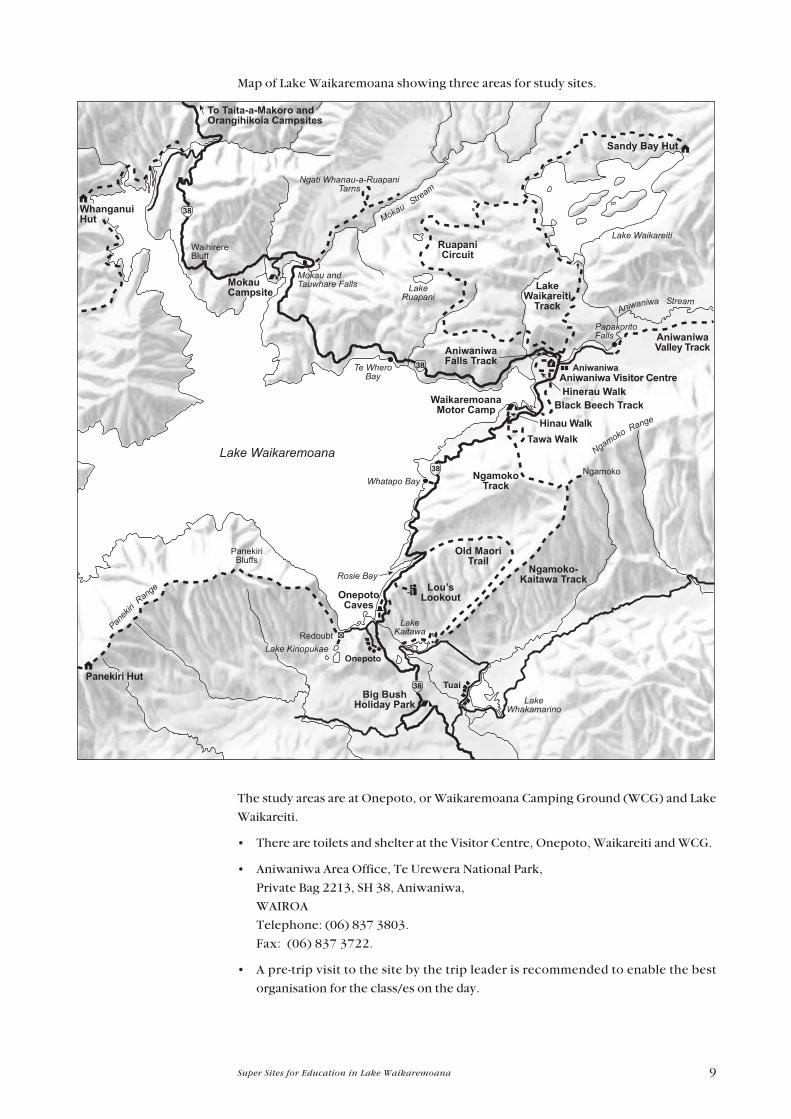
Map of Lake Waikaremoana showing three areas for study sites.
The study areas are at Onepoto, or Waikaremoana Camping Ground (WCG) and Lake
Waikareiti.
� There are toilets and shelter at the Visitor Centre, Onepoto, Waikareiti and WCG.
� Aniwaniwa Area Office, Te Urewera National Park,
Private Bag 2213, SH 38, Aniwaniwa,
WAIROA
Telephone: (06) 837 3803.
Fax: (06) 837 3722.
� A pre-trip visit to the site by the trip leader is recommended to enable the best
organisation for the class/es on the day.
Page 10
10 Super Sites for Education in Lake Waikaremoana
� Do not disturb traps, poison stations and other equipment. There are traps inside
wooden tunnels for stoats at the Visitor Centre and WCG. The traps do not contain
poison but a large snap trap called a fenn trap and a hen's egg. The fenn trap can
easily break fingers if actioned.
� The Visitor Centre can provide a package for schools with information and fact
sheets on animals and plants. In addition there are many interesting and beautiful
walks within easy reach of the Visitor Centre at Aniwaniwa which are well-graded
and clearly signposted and range in length from 5 minutes to whole day. For
information about them refer to the pamphlet Lake Waikaremoana Walks.
Page 11
11Super Sites for Education in Lake Waikaremoana
3 Te Urewera National Park
3 . 1 H I S T O R Y
The history of land tenure and classification in Te Urewera and the establishment of Te
Urewera National Park is very complex goes back as far as the signing of the Treaty of
Waitangi. Before this Maori determine the right to occupy and use land in a number of
different ways including occupation, whakapapa, gifting and the results of conflicts.
The extensive history for the Te Urewera is being researched and recorded as a part of
the documentation for the Waitangi Tribunal claims.
The catchment areas of Lake Waikaremoana, Lake Waikareiti and other Crown
reserves formed the nucleus of Te Urewera when they were gazetted as National Park
on 28 July 1954. By November 1957 the rest of the Crown land north of Ruatahuna
was added to the Park. More additions were made in 1962, 1975 and 1979 with
smaller acquisitions and boundary alterations in the intervening period. The lake bed
and Maori enclaves were not included in the Park gazetting.
The Crown has leased the lake bed of Lake Waikaremoana. The lease was signed on 21
August 1971 for a period of 50 years from 1 July 1967 with right of renewal for a
further 50 years. The Department of Conservation manages the lake bed under the
provisions of the National Parks Act 1980. The public has the right of access in
accordance with statute and the provisions of the management plan.
Crown ownership of lands within Te Urewera National Park has been disputed by
tangata whenua on the basis of the legality of the means by which land was acquired by
the Crown. Formal proceedings have been initiated through the Treaty of Waitangi.
3 . 2 U S E S O F L A K E W A I K A R E M O A N A
� Walking and tramping.
� Swimming and diving.
� Fishing.
� Boating.
� Education.
� Biodiversity monitoring and restoration.
� Scientific and historic research.
� Hydroelectricity generation.
3 . 3 C O N S E R V A T I O N A N D C U R R E N T I S S U E S
There are a number of conservation issues:
� the effect on fish passage of the construction of structures such as dams culverts
weirs etc. and the consequent effect on fish populations.
Page 12
12 Super Sites for Education in Lake Waikaremoana
� Hydroelectric power generation � the lake is now operating at levels 5m below the
natural levels. A new cycle of erosion and related shoreline processes has been
initiated at the lower lake levels which are closely related to the pattern of lake level
fluctuation. The lake levels rise in summer/autumn and fall in winter � reversing
the natural seasonal periodicity. The effects of the significant reduction of natural
flow of water and the cumulative effects of multiple water easements.
� the disposal of sewage is one of the more prominent issues in the Lake
Waikaremoana catchment and throughout the Park. Pollution is caused by
ecologically inappropriate toileting practices; the use of soaps and detergents in
waterways; inappropriate use, handling and storage of fuels; effluent disposal from
boats; and littering of waste and refuse.
� Lagarosiphon major (a lake weed introduced from South Africa) is capable of
displacing all other submerged macrophytes (large water plants) from
approximately 1-6m depth. It presents a particular threat to Lake Waikaremoana
and potentially Lake Waikareiti due to their valuable native aquatic communities.
Lake Waikareiti is the only lake in the North Island that does not have Lagarosiphon
major.
3 . 4 T H R E A T S
Threats to the native flora and fauna include:
� Weed infestations, particularly Lagarosiphon major, and potentially Hydrilla
verticillata, Egeria densa (egeria) and Ceratophyllum demersum (hornwort).
� Introduced predators - both rainbow (Oncorhynchus mykiss) and brown trout
(Selmo trutta)
� The impact of the Hydroelectricity scheme and infrastructure
� Pollution of the lake and water catchment from fuel, sewage, detergents/soaps,
waste and refuse.
3 . 5 M A N A G E M E N T O F L A K E W A I K A R E M O A N A
Management by the Department of Conservation includes:
� Control of weeds.
� Monitoring of forest and lake health.
� Monitoring lake levels
� Scientific research.
� Maintaining and upgrading recreational facilities
� Providing interpretation and publications.
Page 13
13Super Sites for Education in Lake Waikaremoana
3 . 6 M A N A G E M E N T O B J E C T I V E S O F T H E
D E P A R T M E N T O F C O N S E R V A T I O N
� Preservation of the scenery, ecological systems, native plants and animals, natural
features and sites and objects of archaeological and historical interest as far as
possible in their natural state.
� Extermination as far as possible of all introduced plants and animals that threaten
values to be preserved.
� To retain the natural character of Te Urewera National Park as an area of significant
and unique natural values.
� Freedom of entry and access to Te Urewera National Park and appropriate facilities
provided in a manner consistent with the primary objectives for management so
that the public may enjoy the features of, and derive benefits from the Park.
� Management of the Park will be undertaken in manner that gives effect to the
principles of the Treaty of Waitangi.
Protect plants andanimals
Remove rubbish
Bury toilet waste
Keep streams andlakes clean
Take care with fire
Camp carefully
Keep to the track
Consider others
Respect our culturalheritage
Enjoy your visit
Toitu te whenua(Leave the landundisturbed)
ENVIRONMENTAL
CARE CODE
Page 14
14 Super Sites for Education in Lake Waikaremoana
4 Teachers� BackgroundReading
4 . 1 N A T I O N A L P A R K S
New Zealand has 13 national parks and more than five million hectares � a third of
New Zealand � protected in parks and reserves. They embody an incredible variety of
landscape and vegetation for so small a country.
4 . 2 L A K E W A I K A R E M O A N A , T E U R E W E R A N A T I O N A L
P A R K
Te Urewera National Park contains the largest forested wilderness remaining in the
North Island. Lake Waikaremoana is one of the larger lakes in the North Island that is
oligotrophic. It was formed approximately 2200 years ago by a huge landslide which
blocked a narrow gorge along the Waikaretaheke River. Water backed up behind this
to form the second largest, (5,400 ha) but deepest lake in the North Island (248 m).
It is thought that the landslide was probably caused by an enormous earthquake. The
rock debris, which came from the eastern side of the valley, included an intact block of
sandstone which is 3 km long and over 1 km wide. This block of sandstone slid down
from near the present-day Ngamoko Trig. The landslide material covers about 15
square km and may be seen as the hummocky topography with many small lakes
around the Raekahu-Kokako road area.
4.2.1 Resource Description
A lake is a large water-filled depression in the land, inland from the sea. The feature
that distinguishes lakes and ponds from habitats such as rivers and streams is the
relative lack of water movement. Plants that cannot establish themselves in a current
thrive in lakes as do certain species of crustacean. A wide variety of insects exploit the
surface tension of the still water: moving, hunting and breeding on this �micro-habitat�.
The lack of water movement affects the structure and chemistry of the lakes. Oxygen,
the essential ingredient for plant and animal life, enters at the surface. In spring
especially this area has a high oxygen content. During the summer this surface water
warms which causes many lakes to separate into two layers: the upper warmer layer
called the epilimnion and the denser colder layer known as the hypolimnion. The
thermocline is the intermediate zone which separates the two layers. The oxygen is
mainly confined to the epilimnion while the nutrients remain in the hypolimnion. In
the winter when the surface cools the layers are able to mix and the nutrients and
oxygen are dispersed throughout the lake.
The littoral zone is the shallow water at the edge of the lake where most of the lake life
is most abundant because it contains a particularly high density of both nutrients and
oxygen and thus provides ideal conditions for the aquatic flora and fauna. The deeper
and colder water towards the centre supports very little life and in some lakes in the
summer the lake floor is virtually a desert.
Page 15
15Super Sites for Education in Lake Waikaremoana
The nourishment of all lake life is based on the phytoplankton which are microscopic
plants such as diatoms, green algae and blue-green algae. Phytoplankton are fed on by
zooplankton which are equally small animals that include the adults of many
microscopic invertebrate species and the juvenile stages of larger crustaceans and fish.
It is the start of the food chain which leads to adult fish and crustaceans and to aquatic
birds.
4.2.2 Indigenous Aquatic Flora
Aquatic communities occur in Lakes Waikaremoana and Waikareiti and in several
small lakelets and tarns in the Waikaremoana catchment. These water bodies differ in
size and each has a distinctive vegetation type. Characean meadows are the main
macrophyte community in Lake Waikaremoana at all depths to 14m except at the 4m
depth where the introduced Canadian pondweed Elodea canadensis is the most
common macrophyte. Characeans present include Chara urallina, C. globularis
and Nitella hyalina. One scientifically interesting feature of Lake Waikaremoana
which distinguishes it from other North Island lakes is the low spatial variability of the
lake which is almost certainly linked to the homogeneity of the environment. The
aquatic plant communities are vulnerable to the threat of introduced aquatic plants
such as Lagarosiphon major.
In Lake Waikareiti the communities are different and more variable with vegetation
types varying with depth. The diversity of aquatic plant communities within a
relatively small area is valuable for scientific study. Lake Waikareiti currently remains
free of introduced aquatic macrophyte plants.
4 . 3 A Q U A T I C P L A N T I D E N T I F I C A T I O N
A visit to the Lake will be more interesting if you are able to recognise some of the
following plants.
Canadian pondweed Elodea canadensis is the most common macrophyte.
Characeans present include :
� Chara urallina,
� C. globularis
� Nitella hyalina.
Lagarosiphon major is the major problem aquatic weed
4 . 4 I N D I G E N O U S F I S H E R I E S , W H I T E B A I T A N D E E L S
The native freshwater fish known to be present in Te Urewera National Park include:
� Koaro (Galaxias brevipinnis)
� Short-jawed kokopu (Galaxias postvectis)
� Banded kokopu (Galaxias fasciatus)
� Dwarf galaxias (Galaxias divergens)
Page 16
16 Super Sites for Education in Lake Waikaremoana
� Blue-gilled bully (Gobiomorphus hubbsi)
� Red-finned bully (Gobiomorphus huttoni)
� Common bully (Gobiomorphus cotidianus)
� Cran�s bully (Gobiomorphus basalis)
� Torrentfish (Cheimarrichthys fosteri)
� Long-finned eel (Anguilla dieffenbachii)
� Short-finned eel (Anguilla australis)
Several fish species are diadromous, which means they normally undergo migrations
to the sea at various life stages. It is thought that some fish populations are now land-
locked. Data collected shows that many of the fish are large adults and there are few
or no juvenile or sub-adult fish present. This has implications for native fish within the
Park and is an important issue which needs to be addressed.
4 . 5 I N V E R T E B R A T E S
Lake dwelling invertebrates comprise those species which prefer still waters.
The most prominent are the crustaceans - the largest of these is the crayfish or koura.
Other lake crustaceans are the tiny water fleas (Cladocera) and various copepods all
of which are common among both littoral and benthic (deep water) plants.
The most noticeable invertebrates are the ones which live on the surface of the water.
Surface tension gives the water an �elastic� skin and a number of insects have adapted
to exploit this including the pond skaters (Microvelia macgregori and M. oceanica)
and the water measurer (Hydrometra ribesci). The pond skaters have long straddled
legs which spread their weight and air cushions of tiny hairs that prevent them from
plunging through the water surface and drowning.
Swimming below the surface are the waterboatmen (Hemiptera) and the
backswimmers.
Other insects include the caddisflies (Tricoptera), stoneflies, several mosquito species
and dragonflies.
There are also the larvae of non-biting midges known as �bloodworms�; and the hydra.
The hydra is a small soft-bodied animal only a few millimetres in length and consists of
a simple tubular body anchored at its lower end and wreathed in tentacles. It stings its
prey which is chiefly waterfleas.
There has been limited research on both terrestrial and aquatic invertebrates in Te
Urewera National Park, but detailed surveys of caddisflies have located an number of
species.
4 . 6 H Y D R O E L E C T R I C I T Y P O W E R G E N E R A T I O N
The development of this site for the production of electricity was first suggested in
1870 by Captain G. Preece, but it was not until 1920 that the Government began
comprehensive surveys to discover the full potential of the area for the generation of
electricity. Most of the drainage from the lake was through underground passages in
Page 17
17Super Sites for Education in Lake Waikaremoana
the natural rock dam with the water emerging as springs on the slopes above Kaitawa
and whenever the lake flooded it overflowed as well down the outlet of Te
Wharawhara. The springs amounting in all to some 7 cubic metres per second
combine above the Haumapuhia Falls to form the Waikaretaheke River. Its steep
descent over 350m to Tuai makes this site very suitable for the generation of electricity.
Tuai Power Station controls the three generating stations: Kaitawa, Tuai and Piripaua.
4.6.1 History
Tuai Power Station was developed first. Roads and bridges had been built by 1922
and by 1923 two generators had been installed in a temporary building. The plant was
leased to Wairoa Electric Power Board for five years. The rapid demand for electricity
from Wairoa led to the full development of Tuai in 1926. Three horizontal (Francis)
type generators were constructed: two 16,000kW being brought into service in 1929
and the third of 20,000 kW being completed in 1939. Water is delivered from Lake
Kaitawa by two penstocks varying from 1.98m to 1.67m top to bottom with a head of
297.36m and a flow of approximately 14.1 cu m/sec. Power is generated at 11,000
volts, transmitted at 110,000 volts.
Piripaua was begun in 1939. The water from Tuai discharges into man-made Lake
Whakamarino and is then led by a tunnel and twin pipelines (2.8m diameter) to two
vertical (Francis) type generators, each of 20,000 kW capacity, one unit was finished in
1943 and the second in 1944. The working head is 112.8m the flow is 14.1 cu m/sec
and the voltage is 11,000 stepped up to 110,000 for transmission.
Kaitawa was developed as the work was completed at Piripaua. The underground
leaks from the bed of the lake were located by divers and then filled with rocks and
gravel from barges on the surface of the lake. This was reinforced with grouting at
suitable points.
The intake was excavated about 30m in from the original shoreline and 20m below the
lake level and two tunnels (2.5m in diameter) were driven through the slip barrier to
the headgates and penstocks (2.13m in diameter). A single tunnel of 3.05m led from
the intake to the headgates providing a flow of approximately 8.4 cu m/sec at a head
of 135m. The flow can be augmented by means of siphons from the lake which feed
two vertical Francis-type turbines of 21,000hp each driving two generators of 16,000
kW each The first unit came into service in April 1948 and the second in October 1948.
The overflow spillway and control gates at the old lake outlet were not completed until
1955. Permanent siphons were installed with the spillway so water could be drawn
for the two lower stations if ever it should be necessary to close the Kaitawa tunnels.
The total generating capacity of the three stations is 124,000kW with a working head
of 454m at an average overflow fall of 17.5cu m/sec.
4.6.2 Effects of Hydroelectric development
The lake edge has been modified by the hydro electric development which lowered the
level by 5 metres in 1946. The water in Lake Waikaremoana is clear enough to allow
rooted aquatic plants to reach depths of 17-18m. Many aquatic animals depend on
these plants for shelter and feeding areas, but the lowering of the lake has greatly
reduced the area of this zone in which the plants can thrive.
Page 18
18 Super Sites for Education in Lake Waikaremoana
The regular seasonal pattern of lake level variance has also been disrupted by the
hydroelectric development. Before 1946 the lake level rose in winter and fell in
summer, but now control over the outflow allows water in summer to be stored for the
heavy power demand of winter.
The lake level and the transparency/clarity of the water are linked. When the lake rises
in summer, wave action erodes the sunbaked and crumbling papa on exposed shores,
mixing the fine silt with the water and reducing the clarity. The aquatic plants near the
shore are affected by the rising water and the increased murkiness reduces light
penetration. This is important because it occurs when these plants grow the most and
thus affects production at the very base of the food webs in this shoreline zone.
The animals associated with the aquatic plants show natural seasonal periodicity,
tending to be concentrated deeper during summer and migrating into the shallower
water during winter. Dragonfly larvae migrate upwards during the winter into the
shallower weed beds in preparation for their emergence during spring and early
summer. Under natural conditions they would be following a rising lake level, but now
they are threatened during winter by hydroelectric drawdown.
4 . 7 B I O D I V E R S I T Y
New Zealand�s biodiversity is distinct in the world because our native animals and
plants have evolved in isolation over 80 million years. We boast the world�s only
flightless parrot (kakapo, Strigops habroptilus), a bird with nostrils at the end of its
beak (kiwi, Apteryx spp.) a frog which bears live young (Leiopelma species) and the
giant weta, a large insect which fills the role played by mice and other small rodents in
other countries, as well as many other exceptional species.
High numbers of New Zealand�s indigenous species are endemic, that is, they are not
found any where else in the world.
New Zealand has one of the worst records of biodiversity loss in the world. Human
actions including destruction of forests, wetlands and coastal areas for farming have
already led to the extinction of a quarter of New Zealand�s land and freshwater birds,
three out of seven frogs, at least 12 invertebrates such as snails and insects, one species
of fish, one of bats and possibly 11 species of plants.
Today about 1000 of our known animal, plant and fungi species are considered
threatened. This is the forerunner to species extinction.
4 . 8 L A K E W A I K A R E M O A N A
� identify the different aquatic plants
� hear and see a number of bird species,
� look out across Lake Waikaremoana, towards Panekiri Bluff,
� look at the waterfalls,
� discover some lake dwelling invertebrates,
� look under the water
Page 19
19Super Sites for Education in Lake Waikaremoana
4 . 9 H Y D R O L O G I C A L C Y C L E
The hydrological cycle is the movement of water on earth and in the atmosphere.
1. Water falls as rain (hail and snow)
2. Rain filters through the forest layers to be stored as ground water.
3. Excess water is released as run-off into streams, rivers, lakes, and eventually the
ocean.
4. Ground water is used by the forest for natural processes and
5. Is eventually lost into the atmosphere by transpiration.
6. As water reaches streams, lakes and the ocean some will evaporate and return to
the atmosphere to form new clouds.
7. Circulation of the atmosphere moves clouds over the land.
Page 20
20 Super Sites for Education in Lake Waikaremoana
1. Rain
2. Rain absorbed on to leaves and stems trickles down the branches and trunk until it
reaches the litter layer which absorbs vast amounts of water.
3. Water not taken up by the litter layer filters into the soil. Excess water flows from
the soil into streams as run off (4). Some of this water will evaporate into the
atmosphere.
5. Roots take water up from the soil, circulating it within the tree and eventually
passing it back into the atmosphere (transpiration) (6).
Page 21
21Super Sites for Education in Lake Waikaremoana
5 Statements about CurriculumLinks and the Kits
Because this kit is site-based and most kit users will visit the site, the main curriculum
objectives will be based around an environmental theme.
The strongest links will probably be with the science, social studies and health
and physical education documents, although aspects of the technology and the
art curriculums are important in getting the best value from a visit.
Of course the English document is always the basis of any study as the other
documents continually feed in material that develops students� learning in oral, written
and visual language. Similarly, good opportunities exist at all sites to explore many
ideas in all of the mathematics strands.
The best summary of links for the seven curriculum areas can be found in: Ministry of
Education, 1999. Guidelines for Environmental Education in New
Zealand Schools. Ministry of Education, Wellington, New Zealand.
5 . 1 S O C I A L S T U D I E S
Social Studies Education aims to enable students to participate in a
changing society as informed, confident and responsible students.
Lake Waikaremoana, Te Urewera National Park visits and projects offer
opportunities for students, at appropriate levels, to develop concepts in each of
the five strands. Examples for each of the five strands are listed below:
5.1.1 Social Organisation
� how people organise themselves to visit the Lake
� what type of groups of people they are
� how groups organise themselves to respond to Lake Waikaremoana management
issues
� how DoC organises staff to manage Lake Waikaremoana within Te Urewera
National Park.
5.1.2 Culture and Heritage
� aspects of Maori tradition associated with Lake Waikaremoana.
� the use of the Lake by family, boating, community and educational groups.
� Lake Waikaremoana as a significant landmark and landscape feature for people of
Hawke�s Bay, East Coast and the Bay of Plenty.
Page 22
22 Super Sites for Education in Lake Waikaremoana
5.1.3 Place and Environment
� why Lake Waikaremoana is a significant environment for people,
� how peoples� activities influence the Lake Waikaremoana environment,
� how and why peoples� perceptions of Lake Waikaremoana are reinforced or
changed by information or experience,
� how and why people seek to resolve differences over how places and environments
should be used,
� how people express a sense of belonging to the Lake,
� the importance of the lake and environment for recreation.
5.1.4 Time, Continuity and Change
� how past management decisions changed the nature of the Lake,
� how beliefs and ideas in society change and how this has impact on the Lake
� how the process of change over time is used as a tool for Lake management,
� how Maori use of the Lake has changed over the centuries.
5.1.5 Resources and Economic Activities
� how Maori used the Lake as a resource in the past and present
� the European use of the Lake.
5 . 2 S C I E N C E
Learning in science is fundamental to understanding the world in which we live and
work. It helps people clarify ideas, to ask questions, to test explanations through
measurement and observation and to use their findings to establish the worth of an
idea. (Science in the New Zealand Curriculum, p. 7.)
Of the four contextual strands: the living world, the physical world, the material world
and planet earth and beyond, Lake Waikaremoana studies will particularly enhance
development of knowledge, understanding, skills and attitudes in the living world
and planet earth strands.
5.2.1 Living World:
Development of concepts in all of the four achievement aims (Science Curriculum,
p. 52) could be attained during a Lake Waikaremoana project with the first three aims
culminating in an enhanced understanding of the all important Aim Four. This can be
achieved through appropriate activities at any level from one to eight.
Lakes and Rivers
� What are the living and non-living things that make up a lake or a river?
� Design nutrient and water cycles.
Page 23
23Super Sites for Education in Lake Waikaremoana
� Identify aquatic weeds � concentrating on leaf shapes and patterns.
� Introduce Lake Waikaremoana vegetation maps. Why are particular species found
in specific localities or habitats?
B i rds
Identify bird calls:
� Cassette tape
� New Zealand Songbirds.
� Pukaha - Songs of the forest, from Mt.Bruce Wildlife Centre.
� Videos:
� Black Robin - Wild South
� Song of Protection Kokako - Wild South
� Night Parrot / Projection Takahe (48 minutes) � Wild South
� Kiwi (54 minutes) � Wild South
� Kiwi recognition (7 minutes) � DoC
Invertebrates
� Design a key to identify insect.
� Design a trap to catch some insects. Trial it at school.
� Video
� Spineless Wonders (15 minutes).
5.2.2 Planet Earth:
Achievements in Aims One and Two (Science Curriculum, p. 106) lead to
achievement of Aim Four: investigate how people�s decisions and activities change the
physical environment and develop a responsibility for the guardianship of the planet
and its resources. Any achievement in this aim through studies at Lake Waikaremoana
is probably the most important of the entire New Zealand Curriculum Framework.
Research Biodiversity to develop children�s understanding of why New Zealand�s
native plants and animals are unique. Emphasis is placed on Gondwanaland, the
separation of the super-continent and the influence this has had on the evolution of
New Zealand�s biota.
� Videos:
- We Have It All (except snakes) � 8 minutes
- Biodiversity in Aotearoa � Greenpeace.
Interpretation of the extensive views of the surrounding landscape, however
elementary, from the vantage points can help to cement important �our land, our
place, our guardianship� values and attitudes in students of all ages.
Investigations of the aims and objectives of the management plans for Te Urewera
National Park will give important insights into the environmental guardianship role
given to the Department of Conservation by government policy in partnership with
Iwi.
Page 24
24 Super Sites for Education in Lake Waikaremoana
5 . 3 T E C H N O L O G Y
Learning in technology implies becoming confident in using a variety of
means to address needs and opportunities and solve practical problems
within society.
Technology education explores choice and the factors which influence choice,
including culture and society, costs and benefits, aesthetics and fitness for purpose.
It seeks to empower students to make informed choices in the use of technology
and in their response to technological change. (Technology in the New
Zealand Curriculum, p. 8.)
A wide range of opportunities exist through a visit to Lake Waikaremoana
within the context of three strands:
1. Technological Knowledge and Understanding.
2. Technological Capability.
3. Technology and Society.
Examples would include the technologies involved in:
� Animal plant and weed monitoring and control at Lake Waikaremoana
� The generation of electricity
� The development of facilities for visitors such as:
- boating facilities � moorings, jetties, boat ramps
- camping grounds
- signage
- toilets
- shelters
� Aspects of the school trip to Te Urewera such as choices of:
- clothing
- food
- drink
- personal accessories.
� Designing an under water viewing device.
5 . 4 H E A L T H A N D P H Y S I C A L E D U C A T I O N
Lake Waikaremoana visits and projects offer opportunities for students, at
appropriate levels, to develop concepts in each of the four strands. For example:
5.4.1 Personal Health and Physical Development
� Identify and use safe practices and risk management in the lake environment.
� Share ideas and beliefs about how the use of the lake environment enhances a
person�s health.
Page 25
25Super Sites for Education in Lake Waikaremoana
5.4.2 Movement Concepts and Motor Skills
� All achievement objectives in this strand could be met through the development of
concepts relating to safe and efficient water skills in a group situation.
5.4.3 Relationships with other People
� Development of skills relating to planning safe and enjoyable experiences at Lake
Waikaremoana with class or family groups.
� Develop skills in relating to other group members while at Lake Waikaremoana:
� to maximise enjoyment and positive learning experience outcomes.
5.4.4 Healthy Communities and Environments
� Share ideas to identify factors that relate to lake use and community mental and
physical health.
� Identify concepts that are used in the management of the lake environment that
enhance the wellbeing of the plants and animals (ecosystem).
Page 26
26 Super Sites for Education in Lake Waikaremoana
6 General Study Topics
6 . 1 S I G N A G E
Both technology and social studies projects could study the design and construction of
sign messages about conservation.
6 . 2 T O I L E T S
Applicable to both technology and social studies projects. For example a project
could be developed on the �evolution� of the long-drop. Why are today�s versions more
environmentally friendly?
6 . 3 B O A T I N G S T R U C T U R E S
Topics student could look at include:
� The design of:
- jetties
- boat ramps
- moorings
� The needs of boat users which are compatible with park values and other lake
users.
� Costs of maintenance.
6 . 4 W E E D S
The control of weeds is an important management goal. The most problematic
aquatic weed is Lagarosiphon major
� Identify and draw it.
� Suggest methods of eradicating Lagorosiphon major.
Page 27
27Super Sites for Education in Lake Waikaremoana
7 Teacher Study Sheets
7 . 1 S O C I A L S T U D I E S
Debating
During discussions about the place that the Department of Conservation has in
preserving our natural and historic heritage students will realise that people hold
different opinions on that role.
Encourage them to talk to their families, parents, friends etc. to find out what they
consider should be done.
Use the media � for example TV, the newspaper (the free local edition, or the
Education page in newspapers) magazines (if your school subscribes.)
Use Web pages for information or write to organisations that are involved in
environmental issues, such as Forest and Bird, Federated Farmers or the Historic
Places Trust.
Find out about Resource Consents.
These findings can then be used to form debates on issues such as :
� Should more Hydroelectric power development occur at Lake Waikaremoana?
� Should trout be protected?
� Should people pay to use the lake?
� Who should make decisions about management of the Park?
� If oil or minerals were found in Te Urewera National Park � should it be extracted
or mined?
Role playing could cover the same issues.
Surveys
The issues raised in the debating topics could be used to develop surveys to find out
other peoples� views.
Surveys could be developed using criteria such as:
� Age,
� Gender,
� Culture.
Collate information as graphs, percentages, etc.
Results could be presented :
� in the school newspaper,
� at assembly,
� on the local newspaper, or
� shared with other schools.
Page 28
28 Super Sites for Education in Lake Waikaremoana
7 . 2 A U D I O A N D V I S U A L A R T S
This worksheet is designed to give you ideas you can develop with students of any age
group. The suggestions may be developed individually or could become a major,
integrated unit of work, linking many curriculum areas.
Music
The bush provides a wonderful symphony of sound. This could be taken back to the
classroom, either by using a tape recorder, and/or having sound on of the objectives
students focus on during the visit. For example:
� Identify and note down the different sounds heard (in what form students record
this is to be discussed before the visit.)
� Record these sounds in written form.
� Take a tape recorder and record as many different sounds as possible.
� Elect groups to study specific areas, e.g.
- Natural � air, water, land.
- �Man-made� � air, water, land.
Back at school
� Discuss the different sounds heard and recorded.
� Record as many sounds as possible in written form to produce a score of music.
� Using voices and music produce a piece of music that represents the �Voices of
Lake Waikaremoana�.
Plays
The lake also portrays never-ending activities by the creatures in their habitat. These
provide wonderful opportunities for students to develop their imagination. If you
choose this concept, before your visit, you will need to prepare students to observe
closely all the activities on site. These could then be the objectives on which to base
your unit.
� Observe and record the movements and areas creatures are seen and how they
move.
� Record the creatures responses to their environment. What would their response
be if you could understand their language?
� Discuss the effect people have on their environment.
Back at school
� Collate this information into a play for presentation e.g. at school assembly.
� portray the characters using costumes, masks etc.
Art
To develop an understanding of Lake Waikaremoana students� attention needs to be
directed towards the colour, texture and form of the environment.
Page 29
29Super Sites for Education in Lake Waikaremoana
� Feeling the different textures and recording (using crayon and newspaper)
- sand
- plants
- stones
- water
- light
� Observe the colours � above, around and below � a camera will help record.
� Look at the form of plants, birds, fish, animals, water and the landscape.
Back at school
� Develop the above points individually using a variety of media and discuss the need
to look and record them individually.
� When developing form use pencil/charcoal sketching as a starting point.
� Combine the three elements of colour, form and texture to produce a picture. This
can be developed with multi-media and as a group activity.
7 . 3 E A R T H S C I E N C E
In conjunction with visits to Lake Waikaremoana and Te Urewera National Park, the
children will be able to discover the natural processes and forces involved in forming
the landscape. A variety of projects can be developed depending on the site visited, but
much can be done pre and post-visit e.g.
� Discover the meanings of these geological terms, giving a brief description of each
one:
earthquake fault line sedimentary
igneous metamorphic thrust
fold anticline syncline
sandstone mudstone limestone
tephra pumice conglomerate
dip angle
� Discuss and record the processes involved in forming the Park landscape.
� Estimate the geological age of Te Urewera National Park.
� Discuss the formation of Lake Waikaremoana.
� Refer to the topographical map 1:50 000. Find Lake Waikaremoana, the Huiarau
Range, and the Aniwaniwa Stream. Identify cliffs, gorges and fault lines in the area.
In what direction is the land uplifting and sloping?
� Develop a device to measure the dip angle of the hills.
Field trip
� Identify the significant areas of geological importance on the visit to Lake
Waikaremoana
� Study and develop your own conclusions on the formation of Panekiri Bluff.
Page 30
30 Super Sites for Education in Lake Waikaremoana
� Find evidence of other major geological events in the area e.g. folding, thrusting.
� Measure the dip angle of the hills and record your results.
� Study and develop you conclusions about the formation of Lake Waikaremoana.
� What evidence of erosion can you find? Identify the causes and suggest ways of
halting this problem. Write a report on your findings when you return to class.
� Identify various geological events within the soil strata.
7 . 4 W A T E R M O N I T O R I N G P R O J E C T
7.4.1 Water Monitoring Study Sheet
Remember that time spent on preparation at school will ensure better results in
the field.
Equipment
� Nets
� Buckets
� Magnifying glass
� Underwater viewing device.
- Design your own underwater viewing device or take a mask and snorkel.
� Tape measure
� Invertebrate identification sheet
� Aquatic weed identification sheet
� Water testing kit
� Recording sheet.
- Design your own recording sheet at school.
Water Monitoring Activity
� It is best to do this activity in the early afternoon � at the end of lunch when the
group is all together.
� Choose a suitable site.
� Lyn Shannon
Back at school
� Decide how the data can be presented and analysed. A graph something like the
one below may be the choice, together with written summaries.
� Discuss what effect this can have on lake health.
Page 31
31Super Sites for Education in Lake Waikaremoana
7.4.2 Monitoring
The lake ecosystem involves interactions between many different components.
Different parts of the ecosystem and interactions between them, can be used as
indicators of ecosystem health.
When fresh water ecologists and managers check on lake health over a period of time
they find out if the lake is improving, is stable or is declining in overall health. This is
called lake monitoring.
Bird monitoring provides a measure of the changes in the bird community over time
in response to predator control. One method used is the Five Minute Bird Count.
Accurate identification of bird calls is essential when carrying out this exercise. Five
minute bird counts are used to monitor change in the resident bird community over
time. The observer walks a transect comprising �count sites� at 200m intervals. At
each site, all birds seen and heard within a 100m radius are noted over a five minute
period. Species type and numbers of each species are noted within 25m and more
than 25m from the observer. Every effort is made not to count birds more than once.
Observer error can lead to misreporting. It is important to accurately identify the bird,
either visually or by its song. Climatic condition, including wind and rain may influence
bird activity on the day.
Page 32
32 Super Sites for Education in Lake Waikaremoana
7 . 5 W A T E R Q U A L I T Y W O R K S H E E T
FIELD RECORDING SHEET, ATTACH TO CLIPBOARD
N A M E D A T E :
LOCATION
Which invertebrates are you studying? (Name and Number)
What bird species have you seen during f ie ld work. The most common species are: tu i and bel lbird.
The aquat ic birds include the New Zealand scaup, the white - faced heron, Paradise shelduck, the shovel ler
and the pukeko.
Check l i s t
� Fie ld recording sheet
� Cl ip board
� Penci l
� Binoculars (opt ional)
Page 33
33Super Sites for Education in Lake Waikaremoana
8 Other References andResources
Bellamy, David Moa�s Ark � The Voyage of New Zealand, TVNZ/Viking 1990. (Video)
Child, John New Zealand Insects, Fontana Periwinkle, 1974
Crowe, A Life-size Guide to Native Trees, Penguin, New Zealand, 1997.
Department of Conservation Te Urewera National Park Management Plan. Draft. Gisborne: East
Coast Hawke�s Bay Conservancy, 2001
Department of Conservation Website: www.doc.govt.nz
Department of Lands and Survey Land of the Mist: The Story of Urewera National Park, Gisborne:
Department of Lands & Survey, 1983.
Falla, R.A. R.B. Sibson & E.G. Turbott Collins Guide to the Birds of New Zealand, Collins, 1989.
Forest and Bird Website: www.forest-bird.org.nz
Gallen, Rodney & Allan North Waikaremoana: A Brief History of the Lakes of the Urewera National
Park, Te Urewera National Parks Board, 1977.
Hanford, P Native Forest Monitoring: A guide for forest owners and managers. Wellington: Forme
Consulting Group Ltd. 2000.
Also available online at: www.mfe.govt.nz
Learning Media The Ancient Forests of New Zealand, Wellington: Ministry of Education, (video).
LEARNZ Website: www.learnz.org.nz
Meads, Mike Forgotten Fauna, Wellington: DSIR Publishing, 1990.
Ministry of Education Education Outside the Classroom: guidelines for Good Practice. Wellington:
Ministry of Education, 1995.
Ministry of Education Guidelines for Environmental Education in New Zealand Schools, Wellington:
Ministry of Education, 1999.
Ministry of Education Website: www.minedu.govt.nz
Ministry for the Environment The State of New Zealand�s Environment, GP Publications, Wellington,
1997.
Ministry for the Environment Website: www.mfe.govt.nz
Mountain Safety Managing Risks in Outdoor Activities. Mountain Safety Manual 27. 1993.
Parkinson, Brian & Geoffrey Cox A Field Guide to New Zealand�s Lakes and Rivers, Auckland: Random
Century, 1990.
Thornton, Jocelyn Field Guide to New Zealand Geology: An Introduction to Rocks, Minerals and
Fossils. Auckland: Reed Methuen, 1985.
The Mobil New Zealand Nature Series Reed Books
Page 34
34 Super Sites for Education in Lake Waikaremoana
9 Super Sites for EducationResource Kit Evaluation Form
This �Super Sites� education resource is designed to help you plan
exciting learning experiences using parks and reserves administered by
DOC in your area. Is it useful? How can we improve it? Please let us
know!
How did you find out about this Super Sites resource?
Comment:
Was there enough information for you to get an overall understanding of the site? YES/NO
If NO, what else would you like included?
What was the level of the class that used the resources? (Circle the answer)
Year 1 2 3 4 5 6 7 8 9 10
Did the resources help you to meet your curriculum objectives? YES/NO
If NO, how could we improve them?
Were the activities enjoyable? YES/NO
Did they meet the learning needs and interests of your students? YES/NO
Do you have any suggestions for improving them?
Were the suggested activities manageable at this site? YES/NO
Were there any safety concerns arising from these activities, or the site? YES/NO
Comment:
Page 35
35Super Sites for Education in Lake Waikaremoana
Has using this resource helped raise your awareness of an environmental issue in your region? If so, what?
Is your class or group taking on an environmental project as a result of the visit? YES/NO
Comment:
Are you aware of any change in your students� attitudes or behaviour towards the environment/environmental
issues since using this resource?
Comment:
Was this your first visit with a class to a Department of Conservation Super Site? YES/NO
Are you planning any more visits to this or other conservation sites this year? YES/NO
Comment:
How would you like future Super Sites resources and programmes to be developed? (Circle the answer):
New themes Web access More sites Other
Comments:
On a scale of 1-10, how would you rate this resource? (1 = excellent, 10 = poor)
1 2 3 4 5 6 7 8 9 10
Would you use a �Super Sites� education resource again? YES/NO
Have you any other comments about how we could improve this resource?
Please post the completed form to: Community Relations Officer (Education), Department of
Conservation, PO Box 668, GISBORNE.
Thank you!