REPUBLIC OF THE PHILIPPINES DEPARTMENT OF PUBLIC WORKS AND HIGHWAYS PASIG-MARIKINA RIVER CHANNEL IMPROVEMENT PROJECT (PHASE III) SUPPLEMENTAL ENVIRONMENTAL IMPACT STATEMENT IN ACCORDANCE WITH JICA GUIDELINES FOR ENVI RONMENTAL AND SOCIAL CONSIDERATIONS SEPTEMBER 2011
4.4.10 Important Social Bounding and Places……………………………….. 414.4.11 Health…………………………………………………………………. 424.4.12 Religion and Indigenous Belief ……………………………………….. 434.4.13 Heritage………………………………………………………………. . 434.4.14 Gender ………………………………………………………………… 444.4.15 Ethnic Minority and Indigenous People (IP)…………………………. 444.4.16 Awareness of Phase III………………………………………………... 44
CHAPTER 5 POSSIBLE IMPACTS WITHOUT MITIGATIONS..…………….. 46
5.15.2
Possible Impacts without Mitigations based on Available Data/Information…..Overall Evaluation on Environmental Impacts in EIS(1998)…………………..
Mitigation Measures Proposed in EIS(1998)………………………………….. Mitigation Measures for Possible Negative Impacts for Phase III……………..Environmental Management Plan for Phase III…………………………..…….
495051
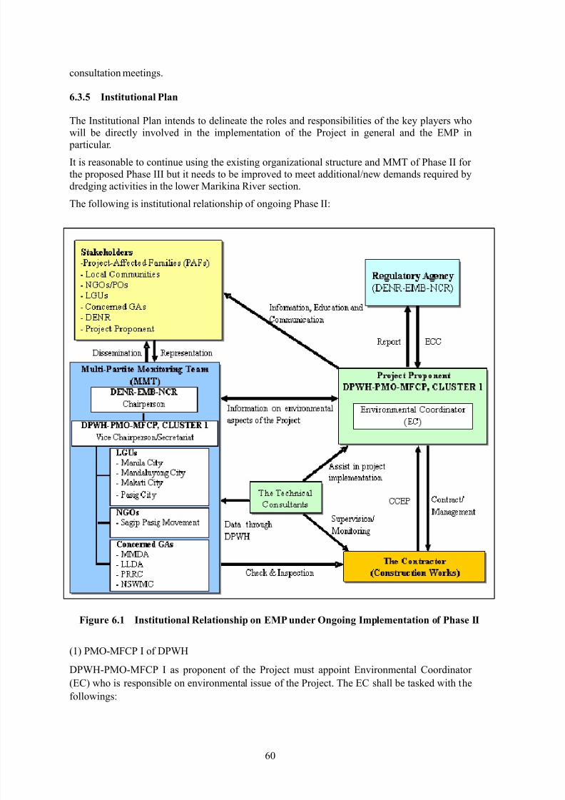
6.3.1 Environmental Management Plan for Mitigation……………..……… 516.3.2 Compliance with ECC Conditions…………………………………… 546.3.3 Possible Required Environmental Permission for Phase III…………. 566.3.4 Information Disclosure and Implementation of IEC……….………… 576.3.5 Institutional Plan……………………………………………………… 60
CHAPTER 8 ENVIRONMENTAL STUDY ON DISPOSAL SITE FORDREDGED MATERIALS………………………………………..… 68
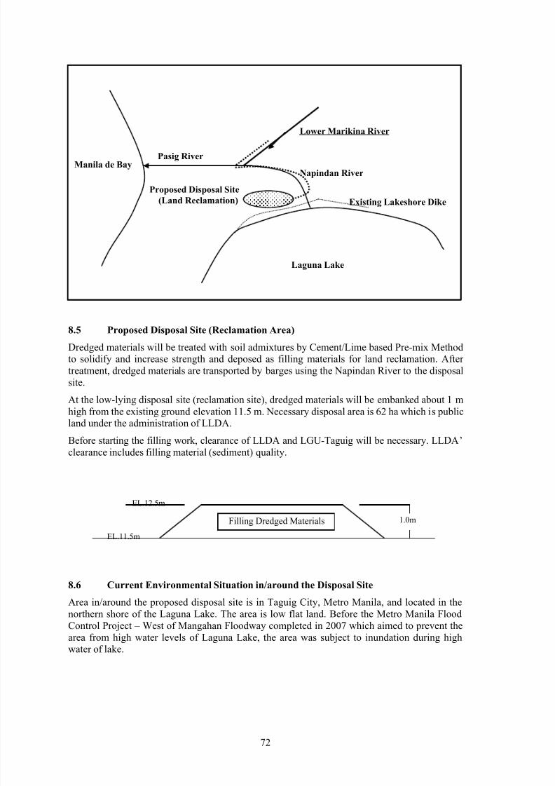
8.1 Laws and Regulations related to Dredged Materials………………………….. 688.2 Status of Riverbed Sediment Quality………………………………………….. 698.3 Further Study on Dredged Materials during Detailed Construction Design…… 708.4 Procedure of River Dredging Works…………………………………………… 718.5 Proposed Disposal Site (Reclamation Area)…………………………………… 72
8.6 Current Environmental Situation in/around Disposal Site……………..……… 728.7 Preliminary Assessment of Impacts around Disposal Site Caused by
Reclamation Works of Dredged Materials……………………………………... 748.8 Environmental Management Plan for Disposal of Dredged Materials………… 758.9 Implementation Plan of Separate IEE/EIS for Disposal Site…………………... 76
8.10 Methods and procedure of Disposal of Dredged Materials in Case ofHazardous Substances Contained……………………………………………… 76
CHAPTER 9 ENVIRONMENTAL EVALUATION IN OPERATION PERIOD
OF PHASE III……………………………………………………….. 77
CHAPTER 10 CONCLUSION AND RECOMMENDATIONS…………………… 78
ANNEX-3 : Scoping Matrix of EIS(1998)ANNEX-4 : Public Hearings/Consultations
LIST OF TABLES
Table 2.1 Overall Comparisons between EIS(1998) and JICA Guidelines………… 4
Table 3.1 Summary of Environmentally Critical Projects (ECPs)…………………. 10Table 3.2 Summary of Environmentally Critical Areas (ECAs)…………………… 10Table 3.3 Project Groups for EIA under PEISS……………………………………. 12Table 3.4 EIS Outline……………………………………………………………… . 13Table 4.1 DENR National Ambient Air Quality Guideline for Criteria Pollutants… 19Table 4.2 DENR Standards for Noise in General Areas (dBA)……………………. 21Table 4.3 Pasig-Marikina River Basin……………………………………………… 26Table 4.4 Inorganic Chemicals in Sediments (mg/kg)……………………………... 27
Table 4.5 Inorganic Chemicals in Sediments (mg/L)………………………………. 29Table 4.6 Environmental Preservation Areas………………………………………. 31Table 4.7 Aquatic Macrophytes found in the Pasig River …………………………. 31Table 4.8 National List of Threatened Fauna in and around Metro Manila Area…. 32Table 4.9 Project Affected Barangays……………………………………………… 33Table 4.10 Estimated Population in the Study Area…………………………………. 34Table 4.11 Estimated Annual Growth Rates in the Study Area……………………… 34Table 4.12 Estimated Population Density in the Study Area……………………….... 34Table 4.13 Estimated Population in the Directly Affected Barangays………………. 35Table 4.14 Estimated Population in the Upper and Lower Sections of Phase III…… 36Table 4.15 Special Economic Zones in NCR ………………………………………… 37Table 4.16 Significant Facilities and Industries Located along the Marikina River
and Major Roads nearby……………………………………………….... 38Table 4.17 Proportional Land Use in Pasig City…………………………………….. 39Table 4.18 Biodata of Households in the Area Directly Affected by Phase III……… 40Table 4.19 Public Places within 20 Minutes Walking Distance……………………… 42Table 4.20 Number of Water-related Disease in Philippines………………………… 42Table 4.21 Significant/Historical Sites and Landmarks in the Study Area………….. 43Table 4.22 Original Region/Province of People in the Project Affected Area……….. 44
Table 5.1 Possible Negative Impacts without Mitigations………………………….. 46Table 6.1 Mitigation Measures in EIS(1998)………………………………………. 49Table 6.2 Suggested Mitigation Measures for Possible Negative Impacts…………. 50Table 6.3 Suggested Environmental Management Plan for Phase III……………… 52Table 6.4 Environmental Permissions to be Possibly Required……………………. 57
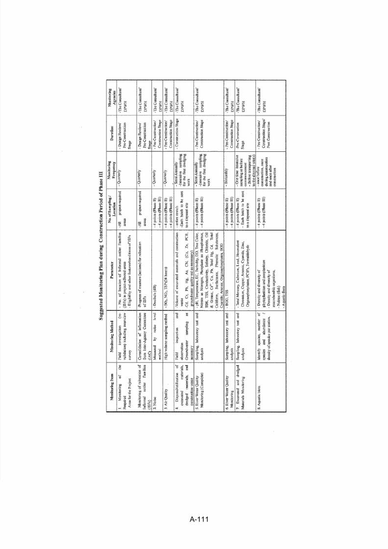
Table 6.5 Record of Public Consultation…………………………………………… 59Table 6.6 Suggested MMT Components…………………………………………… 62Table 7.1 Suggested Environmental Monitoring Plan……………………………… 64Table 7.2 Sampling Locations for Phase III (Construction Stage)…………………. 65Table 7.3 Suggested Monitoring Parameters……………………………………….. 67Table 9.1 Possible Impacts and Suggested Mitigation Measures in the Operation
Figure 3.1 Summary Flowchart of EIA Process………………………………….. 9Figure 3.2 Organization Chart of DENR …………………………………………. 11Figure 3.3 Organization Chart of EMB…………………………………………… 12Figure 4.1 Barangays along the Lower Marikina River …………………………… 17Figure 4.2 Existing Environmental Sampling and Monitoring Locations of
Ongoing Construction of Phase II……………………………………... 18
Figure 4.3 Air Quality TSP Levels in the Area……………………………………. 19Figure 4.4 Noise Level around Phase II Construction Site………………………... 20Figure 4.5 Water Quality (DO, BOD)……………………………………………... 23Figure 4.6 Water Quality (NO3, PO4, TSS, COD, Oil and Grease, Total
Coliform)……………………………………………………………… . 24Figure 4.7 Water Quality (Heavy Metals)………………………………………… 25Figure 4.8 Sampling Locations for Sediment Quality…………………………….. 28Figure 4.9
Figure 6.1
Prevalence Rate of HIV/AIDS…………………………………………
Institutional Relationship on EMP under Ongoing Implementation ofPhase II…………………………………………………………………
43
60
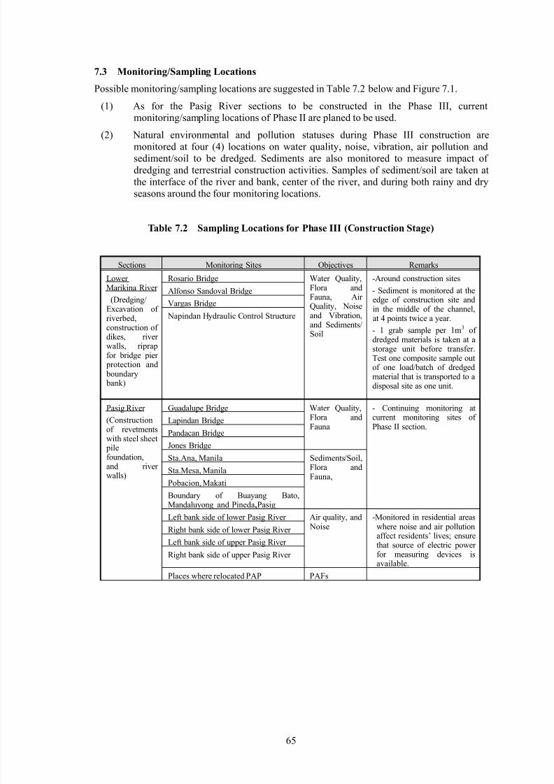
Figure 7.1 Suggested Monitoring/Sampling Locations for Phase III……………… 66
Environmental Impact Statement in June 1998 (hereafter ―EIS(1998)‖) and Environmental
Compliance Certificate (hereafter ―ECC‖) for the Pasig Marikina River Channel ImprovementProject (hereafter ―the Project‖ or ―PMRCIP‖) are reviewed and supplemented to comply with
JICA Guidelines for Environmental and Social Considerations (revised in April 2010 andhereafter ―JICA Guidelines‖) for the proposed implementation of Phase III of the PMRCIP.
1.2 Scope of Work
The EIS(1998) and ECC are reviewed and primary supplemental baseline study is performed inthe JICA Preparatory Study for the Phase III of the Project. The review and supplemental studyis conducted focusing on following:
(1) Validity of ECC,
(2) Compatibility of the EIS(1998) with current Philippines‘ regulatory requirements,
(3) Compatibility of the EIS(1998) with JICA Guidelines,
(4) Validity of primarily appropriateness of the EIS(1998) for the Phase III, and
(5) Providing supplemental information in accordance with JICA Guidelines forEIS(1998), if necessary, for implementation of Phase III:
Baseline status of environment and society of concerned area
Philippines‘ legal and policy framework
Environmental impact assessment
Alternatives
Mitigation measures
Environmental monitoring plan
Financial arrangement
1.3 General Description of the Project
The Pasig-Marikina-San Juan River System, of which total catchment area is 635 km2, runs
through the center of Metro Manila and flows out to the Manila Bay. Its main tributaries, theSan Juan River and Napindan River, join the main stream at about 7.1 km and 17.1 km upstreamfrom the Pasig River mouth, respectively. The three largest waterways contribute largely to the
flooding in the metropolis brought about by the riverbank overflow of floodwaters. MetroManila, which encompasses 16 cities and 1 municipality having a total projected population of
over 11 million, is the economic, political and cultural center of the Philippines.
However, even though the completion of Mangahan Floodway, flood damages along the
Pasig-Marikina River have been frequently experienced in last 25 years between 1986 and2010; 1986, 1988, 1995, 1998, 1999, 2000, 2002, 2004 and 2009. Especially, Tropical Storm‗Ondoy‘ brought a heavy rain and caused devastating flood disasters in Metro Manila, itssurrounding area and Laguna Lake area on September 26, 2009. The heavy rainfall of 453mm/day observed at Science Garden in Quezon City brought a huge volume of flood dischargealong the Pasig-Marikina River, resulting in the death/missing of about 500 people and causingmassive damages.
To cope with such existing flood problems in Metro Manila, the necessity of river channel
improvement of Pasig-Marikina River has been studied. The Department of Public Works andHighways (DPWH) conducted a updated Master Plan (M/P) for flood control and drainage
improvement in Metro Manila and a Feasibility Study (F/S) on the channel improvement of the
Pasig-Marikina River from January 1988 to March 1990, under a technical assistance from theJapan International Cooperation Agency (JICA), called ―The Study on Flood Control and
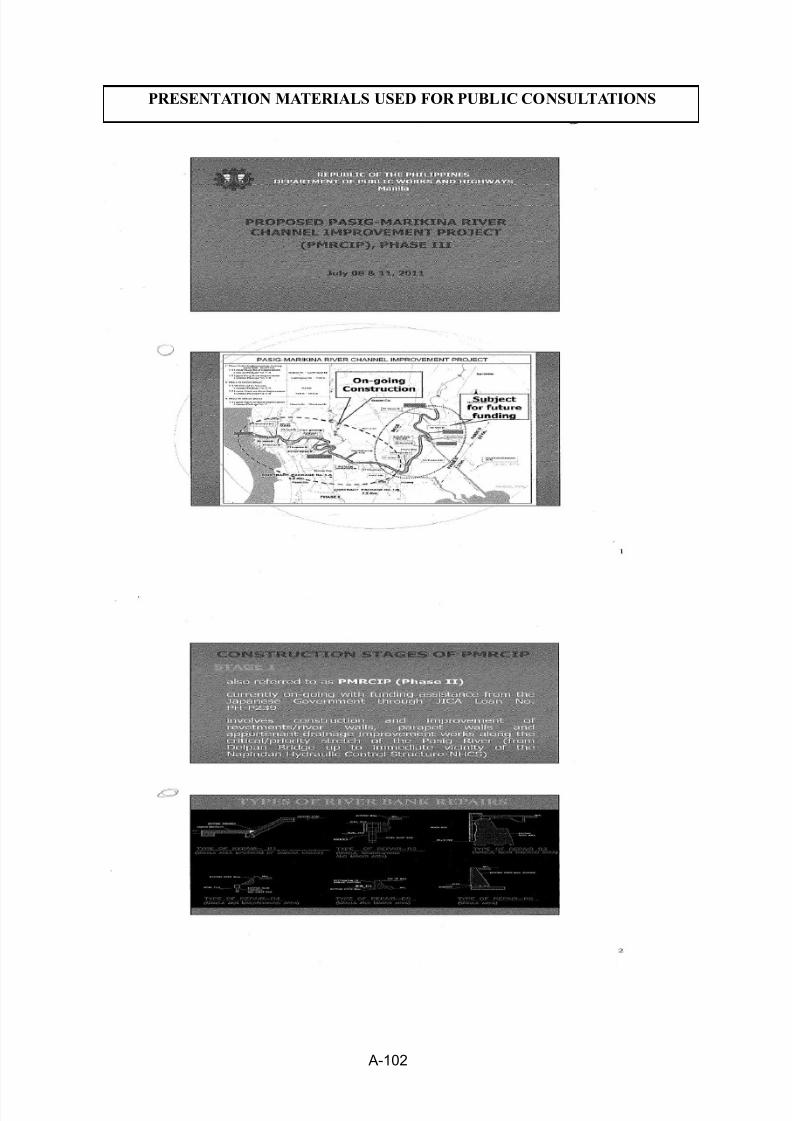
Based on the F/S, the ―Pasig-Marikina River Channel Improvement Project‖ from river mouthto Marikina Bridge (29.7 km long) is being proposed for the implementation in the followingfour phases: Phase I (Detailed Design), Phase II (Channel Improvement of the Pasig River),Phase III (Channel Improvement for the Lower Marikina River) and Phase IV (Channel
Improvement for the Upper Marikina River)The Phase I of Detailed Design (D/D) was carried out from October 2000 to March 2002
through the Japanese ODA assistance. The Phase II has been requested for financing under the26th JICA Yen Loan Package with STEP (Special Term Economic Partnership). The construction
of Phase II Project has commenced in July 2009 targeting the completion of the Project by June2012.
Since the tremendous damages were brought to Metro Manila by Tropical Storm ‗Ondoy‘ in
September 2009, it is urgently required to complete the whole scheme of the PMRCIP to protectMetro Manila against the further flood disaster. Following the ongoing Phase II, it is proposed
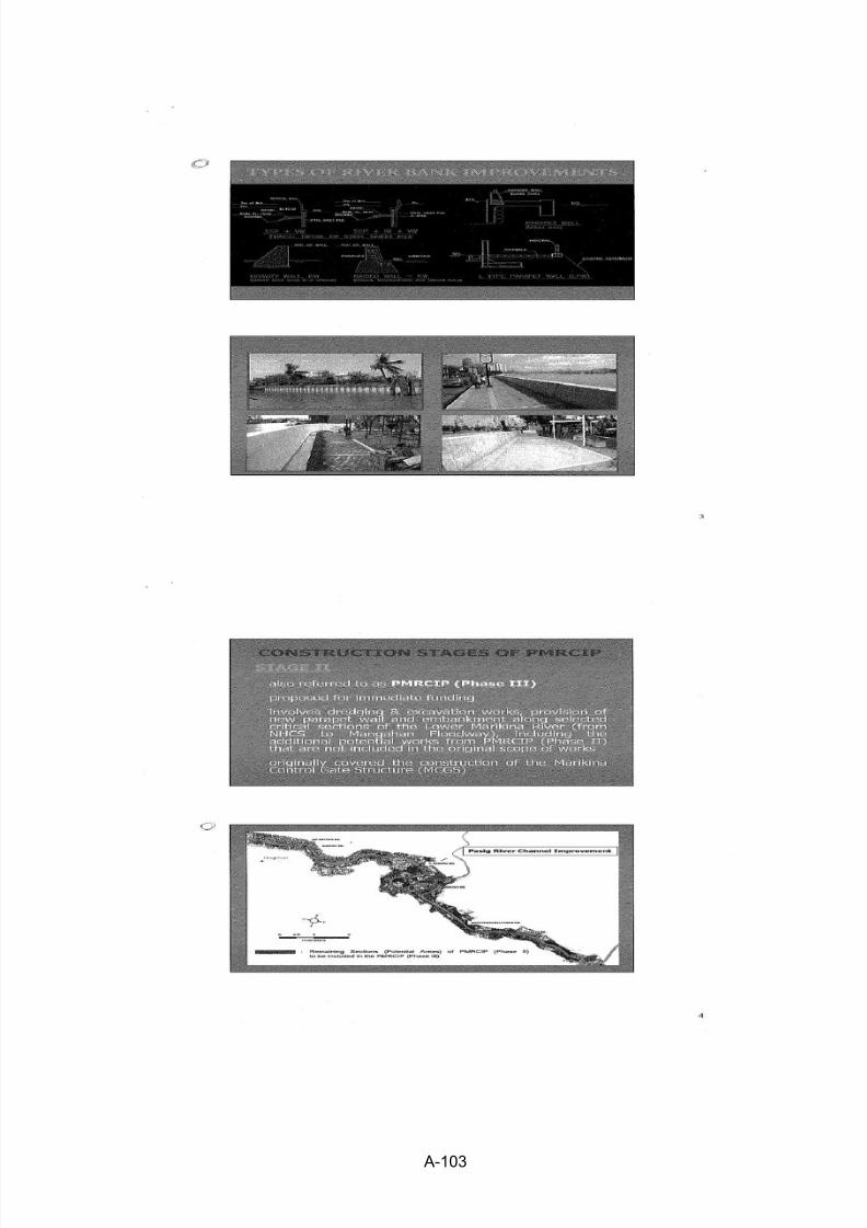
to implement the Phase III which is the Lower Marikina River Channel Improvement Works intotal of 5.4 km upstream from the junction with the Pasig River. Also, heavily deteriorated bank
sections in the Pasig River due to the recent floods including ‗Ondoy‘ is proposed to be includedin the Phase III Project. These sections are not covered by the ongoing Phase II. Constructionarea of Phase III Project is administratively in the cities of Manila, Mandaluyong, Makati andPasig in Metro Manila.
Major works of the Phase III Project are summarized as follow:
(1) Construction of Revetments supported by Steel Sheet Piles and Reinforced ConcreteRiver Wall along the Pasig River (about 9.9 km long in total on both banks)
(2) Dredging of Lower Marikina River Channel (about 5.4 km long; 612,000 m3)
(3) Earth Dikes/Concrete River Walls along the Lower Marikina River (4 location; about
2.15 km long in total)(4) Boundary Bank along Lower Marikina River (about 7.1 km in total)
(5) Bridge Pier Protection Work at 4 existing Bridges along Lower Marikina River (byStone Riprap)
The Pasig-Marikina River flows in the center of Metro Manila which is a capital of the Republicof the Philippines. Both banks of the river channel are currently the urban area and occupied
with residential houses, factories, offices, roads, etc.
To increase the flow capacity of river channel for flood control, measures of widening,deepening, heightening of river wall, short-cut of channel were alternatively studied. Among thealternative measures, to avoid and minimize the social problem such as land acquisition andresettlement, the adopted flood control measure is to rehabilitate/construct the river walls andrevetments on the existing river walls and to deepen the existing channel by dredging, withoutland acquisition for widening the channel.
Moreover, to minimize the negative impacts during project construction, the access to the sitesand required works are planned to be basically done from the river channel using boats/barges.
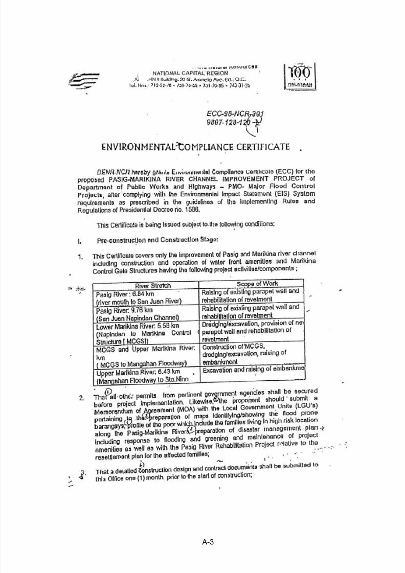
An EIS for the Pasig-Marikina River Channel Improvement Project was conducted in 1998. AnEnvironmental Compliance Certificate (ECC-98-NCR-301-9807-128-120) was granted onDecember 15, 1998 to the Project Proponent (DPWH) based on the submitted EIS (refer toANNEX-1 showing copy of ECC). Ten years after the ECC was issued, when the Phase IIcommenced for construction, the validity of the ECC was confirmed by Department ofEnvironment and Natural Resources - Environmental Management Bureau (DENR-EMB) onMarch 7, 2008.
Once the project is implemented, the ECC remains valid and applicable until the life span of theProject, as long as the Project component were not changed. The conditions and commitmentsstated in the ECC are permanently relieved from compliance only upon validation of the EMBof the successful implementation of the Abandonment/Rehabilitation/Decommissioning Plan.
The ECC automatically expires if a project has not been implemented within five (5) years fromECC issuance, or if the ECC was not requested for extension within three (3) months from theexpiration of its validity.
2.2 Compatibility of EIS(1998) with PEISS (2007) Requirements
The EIS(1998) insufficient information such as Social Development Framework; InformationEducation Campaign (IEC) Framework; Emergency Response Policy and Generic Guidelines;
Environmental Monitoring Plan; Self-Monitoring Plan; Multi-sectoral Monitoring Framework;Environmental Guarantee and Monitoring Fund Commitment; and attached documents of
Impact Assessment and Environmental Management Plan (EMP) Supportive Information.
However, these missing information of EIS document are included in two supplemental
documents/reports which were prepared, when the Phase II had commenced to the construction phase. These two items are (1) Construction Contractor ‘s Environmental Program (CCEP) and(2) Environmental Monitoring and Management Reports (to be submitted quarterly andsemi-annual). Hence, the gaps between the EIS(1998) and PEISS (2007) are eliminatedthroughout actual construction phase. The EIS(1998) along with supplemental reposts satisfiesPEISS (2007) requirements.
2.3 Compatibility of EIS(1998) with JICA Guidelines
The EIS(1998) lacks some requirements given by the JICA Guidelines revised in April 2010 aswell as the World Bank O.P. 4.01 Annex B.
The following items of JICA Guidelines are lacking in the EIS(1998):
i) Legal Framework of Environmental and Social Considerations;ii) Some important criteria to describe social and environmental state; andiii) Involuntary relocation.
The following items which are thought to be important were not discussed in scoping
However, overall contents of the EIS(1998) were basically appropriated based on the JICAGuidelines and the WB O.P.4.01. It is not necessary that the EIS(1998) be completely revised.
2.3.1 Overall Comparisons between EIS(1998) and JICA Guidelines
The following Table 2.1 shows overall comparison results for environmental items to beassessed between the EIS(1998) and the JICA Guidelines.
Table 2.1 Overall Comparisons between EIS(1998) and JICA Guidelines
Phase of the Project
EIS(98)* Phase II**
Need toconsider
forPhase III
Method inthis Review/
SupplementalStudy
RemarksJICA Guideline Items
S o c i a l E n v i r o n m e n t :
1 Involuntary Resettlement Y Yes ◎
2 Local Economy such asEmployment and Livelihood,etc
Housing/Influx ofsquatter: +/-
Influx of outside laborand their families ○
3 Land Use and Utilization ofLocal Resources
Housing/Influx ofsquatter: +/-
Influx of outside laborand their familiesIncrease of demand forhousing and associatedutilities (water supply,toilet, etc.) of outsideconstruction crew
○
4 Social Institutions such as
Social Infrastructure and LocalDecision - making Institutions
N/A N/A ○
5 Existing Social Infrastructuresand Services
N/AImpairment of rivernavigation
○
6 Poor, Indigenous and Ethnicpeople
N/A N/A ◎ (1)
7 Misdistribution of Benefits andDamage
N/A N/A ○
8 Cultural heritage, historicaland religious sites
N/A N/A ◎
9 Recreational Area N/A N/A 10 Local Conflicts of Interest Housing/Influx of
squatter: +/-Influx of outside laborand their families
○
11 Water Usage or Water Rightsand Communal Rights Fisheries: +/- N/A ◎
*EIS(1998) did not use JICA’s method to evaluate the impact using A,B,C, and D.**Phase II did not weight impact but merely noted its possibility.
+/-; Minor impact, N/A: Not discussed, Y: A need of concern was mentioned in discussion but not kept in Scoping matrix.
○: Secondary data, general information, literature/published data
◎: Data collected from primary sources or by actual measurements
Remark※: Data from primary sources or by actual measurements are needed just before construction starts.
Remark (1): “Poor, Indigenous and Ethnic people” is one of new items of concern of JICA Guidelines (2010). Remark (2):”Gender” is one of new items of concern of JICA Guidelines (2010).
2.3.2 Public Consultation and Scoping
The JICA Guidelines require that ―Consultations with relevant stakeholders, such as localresidents, should take place if necessary throughout the preparation and implementation stagesof a project. Holding consultations is highly desirable, especially when the items to beconsidered in the EIA are being selected (in scoping session), and when the draft report is being prepared (Appendix 2 of JICA Guidelines)‖.
(1) Public Consultations
The scoping of the Project was done through several consultation meetings in 1998 whenEIS(1998) was prepared.
a) 1st Consultation
An initial scoping session was held with DPWH-NCR office in February 26, 1998, prior to
the scoping session which was opened to other stakeholders. The initial scoping sessionwas carried out by DPWH, JBIC SAPROF Study Team, and representatives ofDENR-NCR EIA division. The purpose of the initial scoping session was to obtainDENR‘s concerns which must be addressed in the EIS. A scoping matrix being prepared by JBIC SAPROF Study Team was used as a base of the discussion.
b) 2nd Consultation
The second scoping session was held on February 27, 2008 with concerned governmentagencies, LGUs, and NGOs in DPWH Training Room. In this session, various concernsand suggestions were given to the DPWH and SAPROF Team. The participants were fromDPWH, SAPROF Team, MMDA, NGOs and other interest groups.
c) Other Meetings
In addition to the two aforementioned consultation meetings, a KICK-OFF MEETING(February 11, 1998), a STEERING COMMITTEE MEETING (April 20, 1998), and aSEMINAR (May 10, 1998) were held, mostly for government agencies and other interestgroups.
Most of the concerns of all of the above meetings were regarding social and environmental
impacts via dredging activities, affects on Laguna Lake and Manila Bay by operation ofMCGS, and informal settlers situating along the Project sites (the Pasig-Marikina River
and Mangahan Floodway). Through the scoping session, a scoping matrix was formed formajor concerns that were raised by the attendances.
As DAO 96-37 ordered, and as the DENR emphasized in the initial scoping meeting public participation, obtaining full support from the public is very critical to carrying out theProject successfully. However, names of Barangay captains and ordinary persons who live
in the areas where the Project takes place and might be relocated for the Project were notlisted on the attendance sheets.
Although two consultation meetings were held (which was the minimum number ofmeetings required by the World Bank‘s standard), none of them were about the EIS Final
Report.
(2) Scoping
Both the possible positive and negative significant environmental impacts were identifiedthrough the scoping sessions. Agreed-upon items of concern with possible negativeimpacts were (1) dredging activities, (2) construction of the river improvement works
along the banks (construction of revetments and river walls), (3) construction of theMCGS, (4) operation of the MCGS, and (5) operation of the Rosario Weir.
(3) Information Disclosure
DAO 2003-30, Section 5.3 defines a public hearing as part of EIS review, i.e. informationdisclosure. For those who did not participate in public hearings and scoping sessions,
DAO 97-24 assures the provision of ―public access to all official data or information‖.However, the general public faces difficulty in accessing EIS Reports because DAO 97-24Section 3.1.5 treats some of these reports as ―Confidential‖ and forbids the their review.
There is weak evidence in the EIS(1998) regarding the social and environmental concernwere disclosed properly and adequately in accordance with JICA guidelines:
(1) An information dissemination meeting was held at the Bayview Hotel in Manila in
1998. Most of the people who attended the meeting were those of the governmentagencies, LGUs, ADB, and SAPROF. No residents of areas affected by the projectwere included.
(2) The EIS (1998) was written in English which is a official language of the Philippines.Since most of the people living in the Project affected Area use either non-English(52% Households in directly affected area use only Tagalog) or a mixture of someEnglish (48% use mixture of Tagalog or Filipino and non-standard English) withnative tongue, it is deemed to be not easily accessible to the information in the EIS.
2.3.3 Summary of Current Baseline Status of Natural and Social Environment
The followings are the summary results for current baseline status of main environmental itemsfound out during this supplemental study.
(1) Natural Environment (Secondary Data)
Chromium, copper, mercury, nickel, and zinc are highest in the sediment samplestaken at Vargas Bridge in the lower Marikina River. However, these values are lowerthan reference values such as natural sediment quality of State of Washington andmostly satisfy environment values of Canada and the Netherlands.
No rare, protected, nor endanger species are reported in the project-affected area.
Noise and air pollution from construction machinery/equipment seem to be no higherthan back ground levels in the project-affected area..
Spatially and temporally, water quality in the middle of the Pasig River tends to be poorer than that of the Marikina River and the lower Pasig River.
In the Philippines, any private or public projects or activities which are envisaged to potentiallyhave a negative impact on the environment are subject to EIA by Philippine EnvironmentalImpact Statement System (PEISS). The EIA is the preliminary analysis of the potentialimpacts of the project on the environment. Aware of the possible negative effects of theimplementation of industrial and other activities, the Philippine Government has instituted
measures to encourage the use of EIA as a planning and decision making tool.
PEISS is a set of laws, regulations, administrative orders and guidelines concerned withEnvironmental Impact Assessment. The following are some of the most important of these lawsand guidelines:
Environmental Impact Statement System (EISS), Presidential Decree No. 1586 (1978):An act establishing and centralizing the Environmental Impact Statement (EIS) System
under the National Environmental Protection Council (NEPC), which merged with the National Pollution Control Commission (NPCC) in June 1987 to become theEnvironmental Management Bureau (EMB).
Presidential Proclamation No. 2146 (1981) and No. 803 (1996): It proclaimsEnvironmentally Critical Projects (ECPs) to have significant impact on the quality ofenvironment and Environmentally Critical Areas (ECAs) as environmentally fragileareas within the scope of the EIS System.
DAO 96-37 revised to become DAO 92-21: Devolved responsibility for EIS to theEMB-Regional Office and further strengthened the PEISS. Placed emphasis on promoting maximum public participation in EIA process to validate the socialacceptability of the Project.
DENR Administrative Order No. 30 Series of 2003 (DAO 03-30), Revised ProceduralManual (2007): Provides for implementation of rules and regulations of PresidentialDecree No. 1586, establishing PEISS. Also, provided detailed definitions of technicalterms and detailed information regarding procedures, related laws and regulations.
3.2 Procedures
The procedures of EIA can be grouped into the following stages as shown in the followingdiagram: (1) pre-study stage (screening and scoping), (2) EIA study stage and (3) post-study
Source: Revised Procedural Manual for DENR Administrative Order No. 30 Series of 2003 (DAO 03-30)(2007)
Figure 3.1 Summary Flowchart of EIA Process
3.3 Projects Covered by PEISS
Projects which have been originally declared to be Environmentally Critical Projects (ECPs) or projects in Environmentally Critical Areas (ECAs) are assumed to have significant impact onthe quality of the environment and to be subject to PEISS. The four (4) ECP project types andtwelve (12) ECA categories have been declared through Proclamation No. 2146 (1981) andProclamation No. 803 (1996), as summarized below.
Pre Study Stage
EIA Study Stage
Post Study Stage
Project
EIA Study Scoping
EIA Study/ Report Preparation
by the Project Proponent as
a requirement for ECC application
Expansion/Project modifications Implementation
Environmental Impact Monitoring and Evaluation/Audit
Change of
Project
plan/
Relocation
Public
Involvement
No EIAEIA Required
Review and Evaluation of EIA
facilitated by DENR-EMB
Denial of ECCIssuance of ECC w/ recommendations to
other entitles w/ mandate on the project
Secure necessary permits / clearances from other EMB
Table 3.1 Summary of Environmentally Critical Projects (ECPs)
Main Categories Sub Category
A. Golf Course Project Golf course projects/complex
B. Heavy Industries Iron and Steel Metals Non-ferrous Metal Industries
Petroleum and Petrochemical IndustriesSmelting Plants
C. Resource ExtractiveIndustries
Fishery Projects (fishery-related dikes and fishpond development projects)Forestry Projects
Major mining and quarrying projects
D. Infrastructure Projects Major Dams
Major Reclamation ProjectsMajor Power Plants (Proc No. 2146 declared types: fossil-fueled, nuclear fueled,
hydroelectric or geothermal)
Source: Revised Procedural Manual for DENR Administrative Order No. 30 Series of 2003 (DAO 03-30)(2007)
Table 3.2 Summary of Environmentally Critical Areas (ECAs)
ECA Categories Examples
A. Areas declared by law to benational parks, watershed
reserves, wildlife preserves, andsanctuaries
- Areas of the National Integrated Protected Areas System (NIPAS)
B. Areas set aside as aesthetic,
potential tourist spots
- Areas declared and reserved by the Department of Tourism or
other authorities for tourism development
C. Areas which constitute the habitatfor any endangered or threatened
species of indigenous Philippine
wildlife (flora and fauna)
- Areas inhabited by indeterminate species, threatened species, rarespecies, endangered species, such species categorized as AppendixI or II of CITES as well as those listed in the National List of
Threatened Fauna
D. Areas of unique historic,archeological, geological, orscientific interests
- National historical landmarks, geological monuments,
paleontological and anthropological reservations as designated ordetermined by the National Historical Institute, National Museum, National Commission for Culture and the Arts, NationalCommission on Geological Sciences, and other authorities
E. Areas which are traditionallyoccupied by cultural communitiesor tribes
- Areas that are occupied or claimed as Certificated AncestralDomains/Lands by indigenous communities
F. Areas frequently visited and or
hard-hit by natural calamities
(geologic hazards, floods,
typhoons, volcanic activity, etc.
- Areas frequently visited or hard-hit by typhoons- Areas frequently visited or hard-hit by tsunamis- Areas frequently visited or hard-hit by earthquakes
- Storm surge-prone areas
- Flood-prone areas
- Areas prone to volcanic activities- Areas located along fault lines or within fault zones- Drought-prone areas
G. Areas with critical slope- Lands with slope of 50% or more- Alienable and disposable forest lands and unclassified forests
H. Areas classified as prime
agricultural lands
- Irrigated and irrigable areas and other areas mapped under the
Network of Protected Areas for Agriculture (NPAA) of the Bureauof Soils and Water Management (BSWM)
I. Recharged areas of aquifers - Areas of sources of water replenishment
J. Water bodies- Areas that are tapped for domestic purposes- Areas which support wildlife and fishery activities
K. Mangrove Areas- Tidal areas covered by salt-tolerant, intertidal tree species
- Areas declared as mangrove swamp forest reserves
L. Coral Reefs
- Areas characterized by the assemblage of different types of marine plants and organisms
- Areas identified by local sources such as PAWB-DENR to be rich
in corals.
Source: Revised Procedural Manual for DENR Administrative Order No. 30 Series of 2003 (DAO 03-30)(2007)
The proposed Project belongs to the infrastructure category in the Table 3.1 (ECPs). However,this Project is not included in the sub-category of Table 3.1. On the other hand, in Table 3.2 forECAs, this Project is included in Category F.
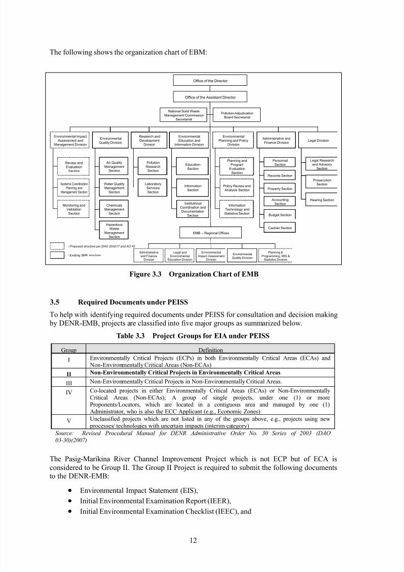
3.4 Responsible Government Institutions for PEISS
Review and supervision of PEISS are conducted by the Environmental Management Bureau(EMB) of Department of Environment and Natural Resources (DENR). The respectiveorganization chart of DENR is shown below:
Figure 3.2 Organization Chart of DENR
The DENR is the government entity which is designated to handle issues related to thefollowing five tasks as described in pertinent legislation:
Assure the availability and sustainability of the country's natural resources through
judicious use and systematic restoration or replacement, whenever possible;
Increase the productivity of natural resources in order to meet the demands for forest,
mineral, and land resources of a growing population; Enhance the contribution of natural resources for achieving national economic and social
development;
Promote equitable access to natural resources by the different sectors of the population;
Conserve specific terrestrial and marine areas representative of the Philippine natural andcultural heritage for present and future generations.
Under the framework of PEISS, the EMB is responsible for the issuance of decision makingdocuments such as Environmental Compliance Certificate (ECC), Certificate of Non-Coverage(CNC) and Denial Letter. Also, the EMB Regional Offices in respective regions are primarilyresponsible for the supervision of development projects and conducting consultation related tosuch projects.
The following shows the organization chart of EBM:
Figure 3.3 Organization Chart of EMB
3.5 Required Documents under PEISS
To help with identifying required documents under PEISS for consultation and decision making by DENR-EMB, projects are classified into five major groups as summarized below.
Table 3.3 Project Groups for EIA under PEISS
Group Definition
I Environmentally Critical Projects (ECPs) in both Environmentally Critical Areas (ECAs) and Non-Environmentally Critical Areas (Non-ECAs)
II Non-Environmentally Critical Projects in Environmentally Critical Areas
III Non-Environmentally Critical Projects in Non-Environmentally Critical Areas.
IV Co-located projects in either Environmentally Critical Areas (ECAs) or Non-EnvironmentallyCritical Areas (Non-ECAs); A group of single projects, under one (1) or moreProponents/Locators, which are located in a contiguous area and managed by one (1)Administrator, who is also the ECC Applicant (e.g., Economic Zones)
V Unclassified projects which are not listed in any of the groups above, e.g., projects using new processes/ technologies with uncertain impacts (interim category)
Source: Revised Procedural Manual for DENR Administrative Order No. 30 Series of 2003 (DAO
03-30)(2007)
The Pasig-Marikina River Channel Improvement Project which is not ECP but of ECA is
considered to be Group II. The Group II Project is required to submit the following documentsto the DENR-EMB:
All documents should be prepared by the project proponent and submitted to the EMB CentralOffice or the Environmental Impact Assessment Division in respective EMB Regional Office.The outcome of the EIA Process within PEISS administered by the DENR-EMB is the issuanceof decision documents. A decision document may either be an ECC, CNC or a Denial Letter,
described below. The PDR is important for some of the implementation of Group II and GroupIII projects, which do not foresee adverse impact, to secure eventual issuance of a CNC.
(1) EIA Proponent
The proponent agency of this Project is the Department of Public Works and Highways(DPWH). The DPWH has the responsibility for preparation and submission of the PEISS.DPWH usually establishes a Project Management Office (PMO) prior to feasibility studies
and the PMO prepares the PEISS. Once the project execution starts, PMO hasresponsibilities for implementation of environmental and social considerations such as landacquisition and resettlement in cooperation with local government units. The EnvironmentalSocial Services Office (ESSO), in the Development Planning Division of the DPWH, isresponsible for supporting and supervising preparation of PEISS.
(2) Environmental Compliance Certificate (ECC)
An ECC is issued as a certificate of Environmental Compliance Commitment, to which the
proponent conforms with after DENR-EMB explains the ECC conditions.
(3) Outline of Required Documents by PEISS
The following is the outline of the EIS according to Revised Procedural Manual of DENR
Administrative Order No. 30 Series of 2003:
Table 3.4 EIS Outline
Project Fact Sheet
Table of ContentsExecutive Summary1) Brief Project Description2) Brief Summary of Project‘s EIA Process 3) Summary of Baseline Characterization4) Summary of Impact Assessment and Environmental Management Plan5) Summary of Environmental Monitoring Plan6) EMF and EGF CommitmentsDRAFT MAIN EIS1. BASIC PROJECT INFORMATION2. DESCRIPTION OF THE PROJECT‘S EIA PROCESS 2.1. Terms of Reference of the EIA Study2.2. EIA Team2.3. EIA Study Schedule2.4. EIA Study Area2.5. EIA Methodology
2.6. Public Participation3. PROJECT DESCRIPTION3.1. Project Location and Area3.2. Project Rationale3.3. Project Alternatives3.4. Project Development Plan, Process/Technology Options and Project Components3.5. Description of Project Phases (Activities/Environmental Aspects, Associated Wastes and Built-in PollutionControl Measures)3.5.1. Pre-construction/ Pre-operational phase3.5.2. Construction/Development phase3.5.3. Operational phase3.5.4. Abandonment phase3.6. Manpower Requirements3.7. Project Cost3.8. Project Duration and Schedule4. BASELINE ENVIRONMENTAL CONDITIONS, IMPACT ASSESSMENT AND MITIGATION4.1. The Land (Discuss only relevant modules)
4.1.1. Land Use and Classification4.1.2. Pedology4.1.3. Geology and Geomorphology
4.1.4. Terrestrial Biology4.2. The Water (Discuss only relevant modules)4.2.1. Hydrology & Hydrogeology4.2.2. Oceanography4.2.3. Water Quality4.2.4. Freshwater Biology4.2.5. Marine Biology4.3. The Air (Discuss only relevant modules)
4.3.1. Meteorology4.3.2. Air Quality and Noise4.4. The People5. ENVIRONMENTAL RISK ASSESSMENT (WHEN APPLICABLE)6. ENVIRONMENTAL MANAGEMENT PLAN6.1. Impacts Management Plan6.2. Social Development Framework6.3. IEC Framework6.4. Emergency Response Policy and Generic Guidelines6.5. Abandonment /Decommissioning /Rehabilitation Policies and Generic Guidelines6.6. Environmental Monitoring Plan6.6.1. Self-Monitoring Plan6.6.1. Multi-sectoral Monitoring Framework6.6.1. Environmental Guarantee and Monitoring Fund Commitment6.7. Institutional Plan for EMP Implementation7. BIBLIOGRAPHY/REFERENCES8. ANNEXES8.1. Scoping Checklist8.2. Original Sworn Accountability Statement of Proponent8.3. Original Sworn Accountability Statement of Key EIS Consultants8.4. Proof of Public Participation8.5. Baseline Study Support Information8.6. Impact Assessment and EMP Support Information
Source: Revised Procedural Manual for DENR Administrative Order No. 30 Series of 2003 (DAO 03-30)(2007)
(4) Public Participation in EIA Process
(a) Information, Education and Communication (IEC) and Public Scoping
One of operating principles of the PEISS is to make accurate disclosure of relevant
information by Project Proponents and other stake holders in the EIA process.
DENR Administrative Order No. 30 Series of 2003 (DAO 03-30) states thatInformation, Education and Communication (IEC) of Local Government Unit (LGU)is required at the minimum of EIS-based applications as part of the social preparation process at Pre-Scoping. In fact, the IEC serves as a basis for preliminary identificationof stakeholders and related issues in preparation for the Public Scoping.
For EIS-based applications, Public Scoping is one of the processes to obtaincommunity inputs prior to the technical scoping of EIA Review Team with the proponent, conducted before signing-off of the Scoping Checklist mentioned, which
comprises the final TOR of the EIA Study.
(b) Public Hearing/Consultation
With an aim of disclosure of the EIA findings, Public Hearings shall be implementedfor EIS-based applications as well as for Environmental Critical Projects (ECP) forwhich Public Scoping was undertaken. A wavier of the Public Hearing requested bythe Proponent may be granted by the DENR-EMB if there is no mounting oppositionor written request for one with valid basis. In such cases, a Public Consultation might be conducted instead.
The notice of Public Hearing shall provide explicit instructions for registration, accessto the EIA report, preparation of position papers, and on mechanics regarding howissues may be received before or during the hearing. Prior to Public Hearings orPublic Consultations, the proponent is required to give copies of the EIA report andrelevant documents to EMB regional offices, LGUs and other stakeholders for a
well-informed participation in the hearing/consultation process.
(c) Participation of Indigenous Peoples for decision-making process
In 2006, NCIP Administrative Order No.1, namely, the Free and Prior InformedConsent (FPIC) guidelines, was promulgated by the National Commission ofIndigenous People (NCIP). The objective of the guideline is to ensure genuine participation of Indigenous Cultural Communities (ICC) and Indigenous Peoples (IPs)
in decision-making as well as to protect the rights of ICCs/IPs in the introduction andimplementation of activities that will impact upon their Ancestral Domains/Lands(ADs/ALs).
Also, the guideline details the process for conducting Field Based Investigation (FBI)
and obtaining the Certification Precondition from the NCIP attesting that theapplicant has complied with the requirements for securing the affected ICC/IP ‘sFCIP. It is required for the EIS (Environment Impact Statement)-based projects
which can affect the ADs to follow the FCIP procedures.
NCIP regional office is responsible for receiving applications for the issuance ofCertificate Precondition as well as implementing FBI and overseeing the process toobtain the FPIC from the IPs/ICCs.
(5) Laws and Regulations Concerning Environmental Standards
Known as the Philippine Environment Code, it launches a comprehensive program on
environmental protection and management. It also provides for air, water quality, landuse, natural resources and waste management for fisheries and aquatic resources;wildlife; forestry and soil conservation; flood control and natural calamities; energy
development; conservation and utilization of surface and ground water and mineralresources.
(b) Water Code (Presidential Decree No. 1067)
A decree instituting a water code which revises and consolidates the laws governingthe ownership, appropriation, utilization, exploitation, development, conservation and protection of water resources.
(c) Clean Water Act (Republic Act 9275)
An Act which aims to protect the country‘s water bodies from pollution from all possible sources (industrial, commercial, agricultural and household activities). It provides for a comprehensive and integrated strategy to prevent and minimize
pollution through a multi-sectoral and participatory approach involving all thestakeholders.
(d) Clean Air Act of 1999 (Republic Act No. 8749)
An Act which lays down policies to prevent and control air pollution. The act setsstandards for exhaust emission from vehicles, manufacturing plants and so on. All potential sources of air pollution must comply with the provisions of the Act. Assuch, all emissions must be within the air quality standards set under the law. It also
imposes the appropriate punishments for violators of the law.
An Act providing for an ecological solid waste management program, creating thenecessary institutional mechanisms and incentives, declaring certain acts prohibited, providing penalties, and appropriating funds therefore, and for other purposes.
(f) Pollution Control Law (Presidential Decree No. 984)
An Act that serves as the foundation for managing industrial activities impacting airand water quality. It empowers the DENR to impose ex-parte cease and desist orders
(CDO) on the grounds of immediate threat to life, public health, safety or welfare, orto animal or plant life when wastes or discharges exceed the normal amounts.
The Forestry Reform Code of the Philippines recognizes that there is an urgent needfor proper classification, management and utilization of the lands of the public
domain to maximize their productivity to meet the demands of the increasing population of the Philippines. It surmises that to achieve the above purpose, it is
necessary to reassess the multiple uses of forest lands and resources before allowingany utilization to optimize the benefits that can be derived. It also emphasizes not
only the utilization, but even more so the protection, rehabilitation and developmentof forest lands to ensure the continuity of their productive condition.
(h) National Integrated Protected Areas System (Republic Act No. 7586)
An Act that aims to protect and maintain the natural biological and physicaldiversities of the environment, notably areas with biologically unique features to
sustain human life and development as well as plant and animal life. It establishes acomprehensive system of integrated protected areas within the classification ofnational parks as provided for in the Constitution to secure for the Filipino people of present and future generations the perpetual existence of all native plants and animals.It encompasses (1) outstandingly remarkable areas and biologically important public
lands that are habitations of rare and endangered species of plants and animals, (2) bio-geographic zones and (3) related ecosystems, whether terrestrial, wetland ormarine.
(6) Laws and Regulations Concerning Solid Waste Management and Disposal
Presidential Decree (PD) No.825 (1975), PD No.856(1975), and PD No.1152 regulatesafe and responsible disposal of solid and liquid wastes, LGU‘s responsibility on
waste management, and treatment methods.
(b) An Act to Control Toxic Substances and Hazardous and Nuclear Wastes,
Providing Penalties for Violations thereof , and for their Purposes, Republic Act
(RA) 6969 (1990)
(c) MMDA Regulation No.96-009 (August 22, 1996)
Prohibiting littering/dumping/throwing or garbage, rubbish or any kind of waste in
open or public places, and requiring all owners, lessees, occupants of residential,commercial establishments, whether private or public to clean and maintain the
cleanliness of their frontage and immediate surroundings and providing penalties forviolation thereof.
(d) MMDA Regulation No.99-009 (August 22, 1999)
Amending MMDA Regulation No.96-009 in order to differentiate dumping fromlittering to determine the appropriate imposable penalties thereof and address the
problem on how to immediately dispose the junk vehicles which have been causingtraffic congestion in many roads in the metropolis.
(e) DAO 36 Series of 2004 (DAO 04-36)
DAO 04-36 is a procedural manual of DAO 92-29, a comprehensive documentationon the legal and technical requirements of hazardous waste management.
Thirteen years have passed since the EIS(1998) was prepared. Hence the social and
environmental situations in location for the Phase III of the Project are naturally and sociallyanticipated to change. Such changes might be or might be not affect appropriateness of theenvironmental impacts and the Environmental Management Plan (EMP) developed in 1998.In order to prepare the way for the next phase of the Project, the important social andenvironmental criteria have to be identified and their integrity be confirmed according to JICA
Guidelines, which also refer to World Bank ‘s O.P. 4.01. Key points of the investigation are asfollows:
Focusing on areas directly impacted by construction works of Phase III, which may causesome possible negative impacts.
Focusing on the current conditions of social and environmental criteria for which concernshould be given according to JICA Guidelines, and
Updating and adding some information that are used to measure social and environmentalimpacts during the construction stage of Phase III.
4.2 Physical Environment
4.2.1 Area of Concern
Barangays that are facing directly to the Phase III area of the lower Marikina River are chosenas a directly affected area by the Project. These Barangays are shown within the boundary linein Figure 4.1.
Figure 4.1 Barangays along the Lower Marikina River
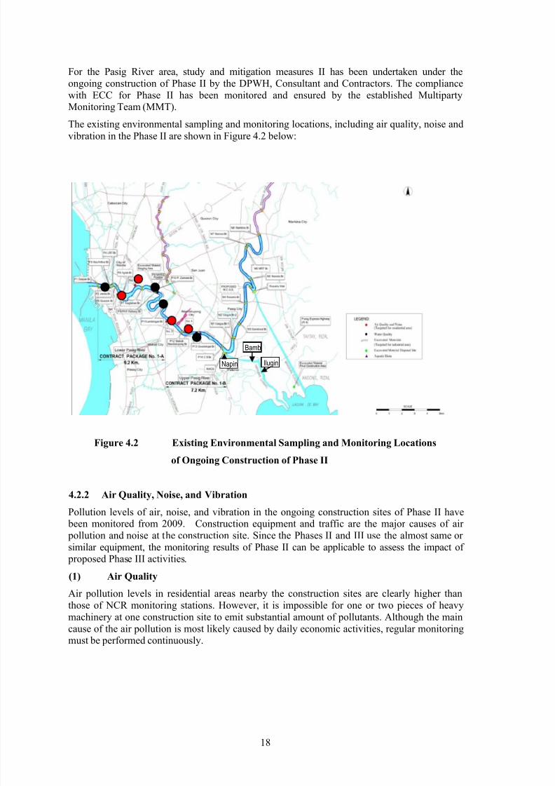
For the Pasig River area, study and mitigation measures II has been undertaken under theongoing construction of Phase II by the DPWH, Consultant and Contractors. The compliancewith ECC for Phase II has been monitored and ensured by the established MultipartyMonitoring Team (MMT).
The existing environmental sampling and monitoring locations, including air quality, noise and
vibration in the Phase II are shown in Figure 4.2 below:
Figure 4.2 Existing Environmental Sampling and Monitoring Locations
of Ongoing Construction of Phase II
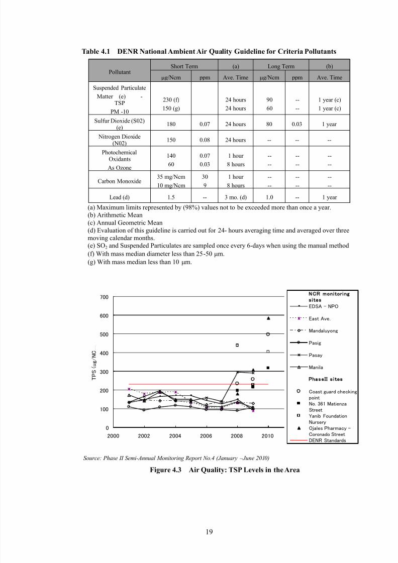
4.2.2 Air Quality, Noise, and Vibration
Pollution levels of air, noise, and vibration in the ongoing construction sites of Phase II have been monitored from 2009. Construction equipment and traffic are the major causes of air pollution and noise at the construction site. Since the Phases II and III use the almost same or
similar equipment, the monitoring results of Phase II can be applicable to assess the impact of proposed Phase III activities.
(1) Air Quality
Air pollution levels in residential areas nearby the construction sites are clearly higher thanthose of NCR monitoring stations. However, it is impossible for one or two pieces of heavymachinery at one construction site to emit substantial amount of pollutants. Although the maincause of the air pollution is most likely caused by daily economic activities, regular monitoringmust be performed continuously.
According to 24-hour noise level monitoring of Phase II in nearby residential areas which arethe most affected, noise levels are not necessary highest during day time (7:00 am-17:00 pm)when construction work takes place. This indicates that although construction contributes tonoise pollution to some degree, most of the noise is from non-construction related vehicles,
passing barges/ferries, and other day-to-day human activities. The following should be notedwith regard to noise pollution in affected residential areas:
(a) Piling activity causes most of the noise in the Project, around 97 dBA while it was 83dBA before piling work started. Although the noise level increases, the piling lasts on
average for 10 minutes per piling work session, which is easily acceptable.
(b) Moreover, while it can be noted that Project construction may generate a considerablelevel of noise, it is considered short-term and therefore minimal in magnitude.
(c) In addition, before starting of the Project construction, the nearby communities wereinformed beforehand that such construction would be implemented. So far, no complaints
from the communities have been reported during Project construction.
**Class A: a section or contiguous area which is primarily used for residential purposes.
Source: Phase II Semi-Annual Monitoring Report No.4 (January – June 2010)
Figure 4.4 Noise Level around Phase II Construction Sites
Table 4.2 DENR Standards for Noise in General Areas (dBA)
TIMECLASS
AA A B C D
Daytime (0700Hr-700Hr) 50 60 65 70 75
Evening (1700Hr-100Hr) 45 50 60 65 70
Nighttime
(2100Hr-500Hr)40 45 55 60 60
Morning (0500Hr-700Hr) 45 50 60 65 70
Class AA – a section of contiguous area which requires quietness, such as areas within 100
meters from school sites, nursery schools, hospitals and special homes for the aged.
Class A – a section or contiguous area which is primarily used for residential purposes.
Class B – a section or contiguous area which is primarily a commercial area.
Class C – a section primarily zoned or used as light industrial area.
Class D – a section which is primarily reserved, zoned or used as a heavy industrial area
(3) Vibration
Vibration level caused by a Vibro-Hammer of Phase II ranges from 0.02 to 0.03 mm/sec within3 meters of the equipment. This is less than 2.5mm/sec applied in Phase II Project which is thelimit that would affect properties. Hence the equipment least likely causes vibration hazardousto the residents in the concerned area.
4.2.3 Water Resources
The Pasig-Marikina River originates at the Southern Sierra Madre Mountain, running thru theLuzon Central Plain to Manila Bay. The Napindan River is one of seven major rivers supplyingfreshwater to Manila Bay from Laguna Lake (Laguna de Bay) through the Pasig River.Although the Pasig-Marikina River is classified as Class C, the water quality and theirenvironment were declared as ―biologically not active‖ in the 1990‘s.
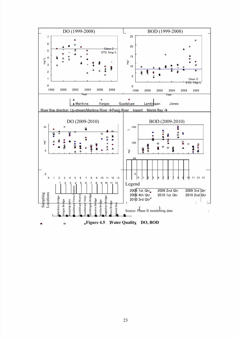
4.2.4 Water QualityOverall water quality is better upstream of Marikina River at Marikina Bridge sampling station.BOD, COD, TSS, Nitrates, Phosphates, Total Coliform, and Cadmium show a similar trend:they start with lower levels at Marikina Bridge, then increase toward Vargas Bridge of LowerMarikina River after merging with highly concentrated water from Buayang Bao creek water.
The trend more or less remains steady from Guadalupe Ferry Station to Havana Bridge in thePasig River, and then, after joining the San Juan River, it decreases toward Manila Bay. Thereverse trend is observed for DO. Almost all parameters for all sampling locations do not satisfyClass C water quality criteria. Oil, Grease and Heavy Metals (except cadmium) do not display aclear trend.
(1) BOD and DO
The trend of Biological Oxygen Demand (BOD) loading has been rising from 1998 to2008. Since 2002, BOD levels at most monitoring stations have been exceeding7mg/L — the Class C river water standard. BOD is low at Marikina Bridge (upstream of theMarikina River) and higher downstream of Havana Bridge — toward Manila Bay (the rivermouth of the Pasig-Marikina River).
The Dissolved Oxygen (DO) level trend is decreasing to below 5mg/L, which is below theClass C river water standard. DO level at Marikina Bridge is generally best of all thestations. DO tends to be high at Marikina Bridge, and it drops when moving downstream
of Havana Bridge, then increases again when moving toward Manila Bay.
Both Nitrate (NO3) and Phosphate (PO4) do not satisfy water quality criteria for Class Clevel. Nitrate level fluctuates within the 5mg/L range below and above the Class-C levelof 10mg/L throughout the rivers. There is no distinguishing difference throughout thePasig-Marikina River. On the other hand, there is a higher concentration of phosphate between the Guadalupe Bridge and Havana Bridge in the Pasig River and also in the flowfrom the San Juan River.
(3) TSS and COD
Both Total Suspended Solids (TSS) and Chemical Oxygen Demand (COD) do not satisfywater quality criteria for Class C. General trends of TSS and COD are low in Marikina
Bridge, increasing toward Guadalupe Bridge, and mostly leveling out until they finally taperout toward Manila Bay. TSS level is mostly above Class C standard of 30mg/L.
(4) Oil and Grease; Total Conliform
Both Oil and Grease and Total Coliform (TC) do not satisfy River water quality for ClassC. The standard for Oil and Grease is 2mg/l and TC is 5,000 MPN/100ml. There is no
trend for Oil and Grease, these fluctuate between 1 and 5 mg/L, mostly above Class Clevel (2mg/L). Total Coliform is mostly between 5000 and 1.36x10
10 MPN/100ml, with a
trend increasing toward Guadalupe Bridge then tapering off toward Manila Bay.
(5) Heavy Metals
Chromium (Cr), lead (Pb), and mercury (Hg) do not have a clear trend, but are equally
dispersed throughout the Pasig-Marikina River. Cr is between diction limit to 0.5mg/L butmostly greater than 0.05mg/L (Class-C std). Pb and Hg clear Class-C std levels of 0.05 and0.0005mg/L respectively. Cd levels increase toward the Manila Bay, between 0.01 and
0.02mg/L, mostly around Class-C level of 0.01mg/L.
The cities located along the Pasig-Marikina River belong to the Pasig-Marikina River Basin,which is a sub-basin of the Laguna Lake Watershed, connecting with the existing MangahanFloodway. The cities‘ political/administrative boundaries do not match with those of thewatershed. The following table shows area coverage of the Pasig-Marikina River Basin.
Table 4.3 Pasig-Marikina River Basin
City/Municipality Total administrativeland area (km2)
Area within the MarikinaRiver Basin (km2)
Administrative areain the basin (%)
Marikina City 23.48 23.48 100
Pasig City 33.77 8.90 26.35
Quezon City 129.84 33.05 25.45
Mandaluyong City 11.3 0.51 4.51
San Jose Del Monte 115.77 11.08 9.57
Rodriguez 360.55 218.58 60.62
Antepolo 293.49 206.52 70.36
San Mateo 53.74 53.74 100
Source: Sewerage Master Plan and Feasibility Study for the Marikina River Basin, (2008) Manila WaterCompany Inc.
4.2.6 Topology and Geology
The Philippines is situated in and along the Circum-Pacific Volcanic-Earthquake Belt, which ischaracterized by earthquakes and volcanic activities. General geological trends north tonorth-west are characterized by the Philippines Fault System and its splay faults, particularlyalong the Southern Sierra Madre Mountains. Two major faults run through the area: theMarikina Fault and Mont Alban Fault. Marikina Fault runs from northeast to south west, alongthe Marikina River, and crosses the Pasig River toward Makati City. Marikina Fault separatesthe valley plain and the plateau/hilly part of Pasig City, and Marikina and Quezon Cities. The
Rolling hills part of Quezon City is located in the Marikina Valley, between the Marikina River
and higher area with a 9% to 18% slope. Soil type for the area is San Manuel Clay.The area of concern for the Phase III is mainly composed of three rock formations: Miocenerock, Alata Conglomerate, and Guadalupe Tuff. Guadalupe Tuff is the type that forms the mainand visible part of Quezon City, foundation of Navatos, and Marikina Valley, which mostlycomposed of comminuted vitric volcanic ash with irregularly layered coarse fragments ofvolcanic pumice. There are alluvium deposit layers on top of the Guadalupe Tuff in the west ofQuezon City toward Navotas. Below Alata Conglomerate there is Miocene rock.
Pasig City is located in Marikina Valley, which is composed of about 86% Marikina Clay loam,and about 14% are on the Guadalupe Plateau Zone. Slope of Pasig City is between 0 and 5%,
and most Barangays are sloped between 0 to 2%, except Bagong-Ilog, Pineda, Kapitolyo, andOranbo Barangays. Elevation of Pasig City is 1 m below mean sea level.
Areas of concern in Quezon and Marikina Cities have gentle slopes of between 0 and 2.5% onthe relatively flat alluvial plain.
The Pasig River Rehabilitation Commission (PRRC) and Phase I (in 2001 in the DetailedDesign) of this Project have been monitoring the Pasig-Marikina River sediment quality. Sincetwo different testing methods, TCLP and Elutriate Test, were used, data obtained from the
monitoring are discussed separately.
(a) Sediment Quality by TCLP
Table 4.4 Inorganic Chemicals in Sediments (mg/kg-dry weight)
SamplingLocation
(Bridge)
SamplingDate
Cadmium
(MDL1=0.9)
Chromium Copper Lead
(LOQ2=20)
Mercury
(LOQ=0.2),
(MDL=0.04)
Nickel Zinc
L a g u n a l a k e
M a r i k i n a R i v e r
Marikina 08/06/09 <MDL 42 101 12.5 <MDL 33.5 185
12/11/09 <MDL 35.5 99 19.85 0.055 32 195
Rosario
(Lower
Marikina)
2001 0.55 (1.11*) 75.57 14.88 <0.003 99.45
Alfonso
(LowerMarikina)
2001 0.91 (0.92*) 83.23 13.53 <0.003 99.45
Vargas
(LowerMarikina)
08/06/09 <MDL 56.5 125.5 25 0.19 38 320
12/11/09 <MDL 36 113.5 26 0.15 36.5 239
2001 0.89 (1.16*) 108.9 63.57 0.15 263.59
Napindan 08/06/09 <MDL 29 79 12 0.06 14.50 125
12/11/09 <MDL 28.35 102.5 17.5 0.050 27 202.5
2001 0.55 (0.96*) 97.79 37.87 0.17 289.29
Bambang 08/06/09 <MDL 33.5 91.5 45 0.089 19.5 250
12/11/09 <MDL 28 81 42.5 0.08 27 250
Ilugin 12/11/09 <MDL 16.2 59.5 21.5 12.5 205
Japan Soil Pollution
150 250 150 15
Allowable valuein Canada3
Agriculture 3 8 150 375 0.8 600
Residential 5 8 100 500 2 500
Commercial 20 500 1000 10 1500
WashingtonState
Sediment standard
5.1 260 390 450 0.41 140 410
UK
(ICRCL)
Garden use 3 254 130 500 1 70 300
Parks 15 10005 1306 2000 20 706 3006
The Netherlands Targetvalue7
0.8 100 36 85 0.3 35 140
Intervention8
20 800 500 600 10 500 3000Method of Analysis: GC/MS (Scan Method, acquisition) determination after extraction with methanol in DCM andhexane and cleanup in alumina column
*As Cr 6+
1. MDL: Method Detection Limit; 2. LOQ: Limit of Quantitation; 3. Interim Canadian Environmental Quality Criteria forContaminated sites (in EIS1998); 4. As Hexavalent (Cr 6+); 5. As Total Cr; 6. As long as plants grow; 7. Dutch‘s finalenvironmental quality goal value; 8. The degree of soil quality that is required a clean-up work.
Source: PRRC, EIS(1998) and Detailed Design (Phase I).
The placement of sampling stations runs from Marikina Bridge crossing upper MarikinaRiver, located in the 30 km upstream from the river mouth, to Vargas Bridge in the lowerMarikina River and toward Laguna Lake through the Napindan River. Bambang Bridgeand Ilugin Bridge are located in Napindan River, which connects to Laguna Lake. Theirlocations are shown in Figure 4.8.
Vargas also shows high lead values after Bambang. However, these values areless than the target value of the Netherlands, i.e. environmentally safe.
Levels of cadmium are at a safe level in the lower Marikina River according to
various reference values (with the exception of the target value employed by the Netherlands).
Figure 4.8 Sampling Locations for Sediment Quality
Chromium in the lower Marikina River is at an environmentally safe levelaccording to standard of Washington State and the Target Value employed by the
Netherlands, but this chromium level is not recommended for agricultural andresidential use in Canada.
Copper in the lower Marikina River is at an environmentally safe level accordingto standard of Washington State but does not conform to the Target Value of the Netherlands.
Lead in the lower Marikina River is at an environmentally safe level according toall the reference values.
Mercury in the lower Marikina River is at an environmentally safe levelaccording to all the reference values.
Nickel and Zinc in the lower Marikina River are at an environmentally safe level accordingto all the reference values, but not conformed with the Target Value of the Netherlands.Chromium, copper, mercury, nickel, and zinc are highest in sediment samples taken atVargas Bridge in the lower Marikina River. However, these values are lower than referencevalues such as natural sediment quality of State of Washington and mostly satisfyenvironment values used by Canada and the Netherlands.
Hence, according to this method, TCLP, it can be said that disposal of dredged materials isless likely to cause contamination of surfaces and groundwater via the leaching process if
sediment quality is equal to or less than reported levels.
TCLP (Toxicity Characteristic Leaching Procedure) is recommended by the DENR. TCLP
is sometimes conducted to determine the leaching potential of sediments under more severeconditions to measure an effect of dredging action. Test Methods for Evaluating Solid
Waste (SW-846) Method 1311 (US EPA, 2009) are used.
(b) Sediment Quality by Elutriate Test
All the values taken from the lower Marikina River are less than regulatory levels set by
the Government of the Philippines. This indicates a decreased likelihood that dredgingcauses significant levels of toxicity to occur in the river water, except perhaps for turbidity.
Table 4.5 Inorganic Chemicals in Sediments1 (mg/L)
Sampling Location Cadmium Chromium Copper Lead Mercury Zinc Arsenic Cyanide
1. Source: Phase I (Detailed Design in 2001); 2. Procedural manual Title III of DAO 92-29 ―Hazardous WastesManagement‖, DAO36(2004); 3. DAO 90-35; 4. DAO 90-35 Table 1 Effluent Standards (maximum limits for the protection of public health): Discharge limit from new/proposed industry to Inland water (Class C); 5. US EPA.
Elutriate Test method was developed by the U.S. Army Corps of Engineers to simulate a
condition that occurs during a dredging operation. An amount of chemicals that is
absorbed to sediment and that may reabsorb into the water column under normal pH is
estimated. When dredging effects are a study objective, elutriate analysis should be
Social survey conducted in the JICA Preparatory Study shows that 84% of households answeredthat their wastewater is going to collection pipes that are connected to a city sewer. However,there are very few sewer collection systems; as of 2006 only 8% of people were served bysewerage systems in Pasig City, while the percentages of people served in Quezon and Makati
cities were 20% and 25% respectively. Marikina city and Pateros municipality are not connectedto a sewer system at all. Also, during the field investigation in JICA study it was observed thatraw wastewater is discharged into the river from most of houses located on the river banks.
Social survey results show that 94% of households‘ garbage is collected and disposed of by a
regular garbage collection system. About 5% burn their garbage and another 5 % discardgarbage into the river or open spaces intentionally. Safe and sanitarily solid waste disposal sitesdo not exist in Pasig city. In Quezon city there is an open dumping site located in Payatas in
close vicinity to La Mesa dam, which is a source of drinking water to Metro Manila.
Cities encourage their citizens to separate recyclable and reusable materials from other garbage.The garbage is collected by LGUs and private garbage collectors. Industrial hazardous and toxicmaterials must be separated and safely disposed of by licensed contractors (DAO92-29,
DAO2004-36). Although there are many ―recycle centers‖ that collect and process usable―recyclable materials,‖ these are more like conventional ― junk shops‖ and are not capable oftreating complex, highly toxic, and mixed hazardous wastes such as industrial wastes. As of2002, only three (3) hazardous waste treatment facilities that are equipped with appropriatetechnologies and skilled workers were identified. Hence, it can be said that some of thewastewater from the Pasig and Quezon cities are still discharged into the river one way oranother and that this discharge is the major source of river water and sediment pollution.
4.2.9 Protected Area
Republic Act No, 7586, titled the National Integrated Protected Areas System (NIPAS) Act, prescribes the following eight (8) categories of protected areas: (1) strict nature reserve, (2)natural park, (3) natural monument, (4) wildlife sanctuary, (5) protected landscapes and
seascapes, (6) resource reserve, (7) natural biotic areas and (8) other categories established bylaw, conventions or international agreements which the Philippine Government is a signatory.
Protected area nearest the Phase III site is Marikina Watershed Reservation (18,965.86 ha)which is located about 20 km upstream from the project site, Lower Marikina River, in Antipolocity and Montalban municipality in Rizal Province. Therefore, no adverse impact is predicted.
Candaba Swamp and Manila Bay have been nominated as Important Bird Areas by Bird LifeInternational. Candaba Swamp is located in the Pampanga River Basin about 60 km far (straightdistance) from the Pasig-Marikina River. Bird area of Manila Bay is located around Cavite area,20 km far from Pasig River. Therefore, no adverse impact is predicted.
4.2.10 Recreational Area
The PRRC initiated the creation of Environmental Preservation Areas (EPAs) in order to promote a cleaner Pasig River. The EPAs take the form of linear parks, walkways andgreenbelts on both sides of the Pasig River. So far, a total of 24.64 linear kilometers of parkshave been completed extending from the City of Manila to Taguig City.
Protected Area and other Environmental Preservation Areas (EPAs)
Pasig
Pineda Linear Park
Buting Linear Park
West Rembo Linear Park
Makati
Vergara Linear Park
Hulo Linear ParkBarangka Itaas Linear ParkBarangka Ibaba Linear ParkBarangka Ilaya Linear ParkBuayang Bato Linear Park
Tagig Napindan North Riparian Forest
Source:. www.prrc.com.ph (2011), PRRC
4.3 Biological Environment
4.3.1 Flora
(1) Terrestrial Flora
The riverbanks serve as habitat for a few thriving natural plants, the majority of which areFicus spieces. Agricultural fruit trees and ornamental plants were also observed on the banks of the Pasig River. The terrestrial plants along the embankment of the river stretchwere recorded. Among the commonly encountered plants in the riverbanks, either plantedfor bank enhancement and shade or occurring naturally through seed dispersal agents aswind, insects and birds, are Ficus religiosa, Leucaena leucocephala, Terminalia catappa,Sandoricum koetjape, Swietenia macrophylla, Cocos nucifera, Ficus septica, Tremaorientalis, Ficus balete and Gmelina arborea.
Other species recorded but not frequently encountered include Vitex parviflora, Carica papaya, Pterocarpus indicus, Premna odorata, Chrysophyllum cainito, Cannax generalis
and Macaranga tanarius.
(2) Mangrove
It was reported that mangrove areas have declined significantly in the Manila Bay area dueto conversion of land use. For instance, in 1994, it was estimated that there were 1,276 haof mangrove forests in the Bay. In 2005, the Environmental Resource Validation by Manila Bay Environmental Atlas identified 414.15 ha of mangrove forests in the Bay.
(3) Aquatic Flora (Macrophytes)
The aquatic biota is low diversity of macrophytes in the Pasig River, which can beattributed to river pollution and concentration of population in the nearby areas.
The same or similar habitat and biological characteristics can be expected in the Marikina
River and its surroundings.
Table 4.7 Aquatic Macrophytes found in the Pasig River
Species Common name Family Remarks
Eichornia crassipes Water hyacinth Pontederiaceae Exotic
highly-developed Metro Manila area, exclusively in and along the already highly-pollutedand disturbed Pasig-Marikina River.
(2) Nektons (fish)
Ancistrus temminckii, commonly known as ―janitor fish,‖ was the only fish species caughtduring the aquatic biota sampling. The Janitor Fish is an invasive specie, which was
brought for a research purpose from out of the country, and not a native of thePasig-Marikina River. The greatest number of janitor fish caught and observed was in
Guadalupe Bridge. None were caught at Lambingan Bridge.
(3) Zooplankton
Three groups of zooplankton were found in four sampling stations in the Pasig River. As inmost tropical freshwaters, results show that the zooplankton population is dominated byCladocerans, with 46% of the total population count of zooplankton in all of thesampling stations. Diaphanosoma excisum is the species notably recorded as the mostabundant among the other Cladoceran species.
(4) Macrobenthos
Oligochaetes and dextral pond snails dominate the macrobenthic population,
occupying 48 % of the total collection in all sampling stations. Oligochaetes belongto Phylum Annelida, which are known as well-segmented worms.
The river snail, which belongs to family Pleuroceridae, holds 19% of the totalnumber of collected macrobenthic organisms.
Shrimp are the least number in the macrobenthic community with 5% dominancy.They are under the Subphylum Crustacea, that requires well-oxygenated water. This
explains its low dominance among the macro invertebrate species in four stations.
Corbicula manilensis, commonly known as ―tulya,‖ was observed in Guadalupe
station since the station is near Laguna de Bay. Few individuals of Pomaceacanaliculata, or ―golden kuhol,‖ were also obtained from all the four stations.
4.4 Socio-economic Environment
4.4.1 Area Directly Affected by Construction
Phase III activities involve dredging more heavily than in Phase II. River bank revetment works,river wall works and repair works of existing revetments are going to be given to sectionsgeographically allocated to both Phase II and III. Construction procedure, monitoring, andconstruction site managements in Phase III would be more or less the same as that of Phase II.Considering the scale and nature of construction activities in Phase III, directly affected areasalong the Lower Marikina River are identified to be all Barangays located in between theMangahan Floodway and Napindan River. Such concerned Barangays are listed in a table below.
Pasig City, where most of Phase III of construction sites takes place, experienced about a 1.6fold population growth between 1990 and 2007, from 397,309 to 627,445 in 17 years.
The populations and annual average growth rates from 1990 to 2007 in the Study Area areshown in the below table.
Table 4.13 Estimated Population in the Directly Affected Barangays
2000 2007
Quezon City (Total) 2,173,831 2,679,450
Bagumbayan 7,597 9,209
Ugong Norte 6,959 6,822
Pasig City (Total) 505,058 627,445
Ugong 19,034 22,266
Bagong Ilog 16,423 15,454
Pineda 16,655 15,013
Santolan 37,055 43,286
Manggahan 32,615 38,063
Rosario 48,998 50,690
Maybunga 24,529 35,627
Caniogan 23,553 21,769
Kapasigan 6,178 6,569
San Jose 1,575 2,347
Bagong Kapipuan 1,044 1,185Santa Rosa 1,120 1,515
Buting 10,408 9,073
San Joaquin 10,694 12,498
Source: www.census.gov.ph , Demographic Statistic, National Statistic Office
Overall populations in Pasig City increased about 24% on average between 2000 and 2007. Itcan be assumed that social, commercial and industrial activities in such areas have increased as population grew, which in turn resulted in changing mutual influences of the cities and the riversince the EIA report was prepared in 1998.
Most of the lower Marikina River runs through Pasig City. Pasig City‘s population increased
from 505,058 in 2000 to 627,445 in 2007. Maybunga, one of 14 major Barangays located alongthe river, increased its population by 11,098 people by 2007, which is 45% growth whenmeasured from 2000. While Barangay Buting lost 1,335 people, its neighboringBarangays — namely San Jose, Banong Kapipuan, and Santa Rosa — gained 1,308 people all
together from 2000 to 2007.
Barangays Santolan and Mangahan, located upstream from the Phase III section, each increasedtheir populations about 17%. This implies that about 2,500 households (1 household contains4.66 people in Pasig City) have moved into the two Barangays between 2000 and 2007. Ugong,
another major Barangay located in the middle of the Marikina River, has increased its population from 19,034 in 2000 to 22,266 in 2007. This indicates that about 700 newhouseholds moved into Ugong since 2000.
Residents in the projected affected area originate from neighbouring cities as well as from otherislands, such as: Albay, Samar, Pangasinan, General Santos, Iloilo, Sorsogon, Cagayan,Misamis Oriental, Negros Occidental, Bacolod, Zamboanga, Marinduque, Legaspi, Masbate,Quezon, Bulacan, Surigao, Cebu, Oriental Mindoro, Pampanga, Mindanao.
Populations in Barangays that are located upper and lower streams of Lower Marikina Riversection are listed in the table below.
Table 4.14 Estimated Population in the Upper and Lower Sections of Phase III
2000 2007
Makati City
Total 444,867 567,349
East Rembo 23,902 23,119
West Rembo 28,889 28,578
Cembo 25,815 26,589
Guadalupe Nuevo 22,493 23,359
Marikina City
Total 391,170 424,610
Industrial valley 13,366 14,050
Calumpang 14,552 15,589
Barangka 19,466 17,424
Tanong 9,477 9,360
Jesus de la Pena 9,796 8,553
Santa Elena 5,704 7,008
Conception Uno 76,736 40,277Malanday 42,256 51,363
Nangka 32,273 41,837
Santo Nino 27,602 24,694
Conception Dos 23,845 27,809
Source: www.census.gov.ph , Demographic Statistic, National Statistic
Office
Barangays East Rembo, West Rembo, and Cembo in Makati City are located 2 km directlydownstream of the lower end of the lower Marikina River section. While Makati City‘s population increased about 83,000 people (approx. 17%) between 2000 and 2007, the
populations in the three concerned Barangays has increased less than 1%, and rests weredecreased.
Marikina City, which is located above the Mangahan Floodway, has increased about 19% in the7 years following 2000. Santa Elena, Conception Uno, Malanday, and Nangka have changedtheir population about 23%, -48%, 22%, and 30% respectively since 2000. Reduction of population in Conception Uno, which is located in the upper edge of Marikina City, is thegreatest of all; 36,459 people — or about 7500 households (1 household is 4.86 people inMrikina City) — had moved out in a 7 year-period. Meanwhile, Barangays Malanday and Nangka, which are located right next to Conception Uno, increased their populations about9,100 and 9,600 respectively during the same time period. Between 2000 and 2007, BarangayParang also lost about 45% of its population (30,136 people), while its neighboring BarangaysMarikina Heights and Conception Dos gained about 10,000 people.
4.4.3 Development Trend
Commercial development in Pasig City increased 100% between 1994 and 2000, whiletraditional industrial activities have remained stagnant. Development of pedestrian malls,
high-rise mixed-use condominiums, and warehouses has risen in the last 10 to 20 years, whileindustry lost about 3.5% of its land for commercial use by 2000. Industries in Ugong, Rosario,Santolan and Kapitolyo baramgays have hardly expanded during the last 20 years or more, butrelocated to the neighboring regions of CALABARZON and MMARILAQUE. Residential areais shifting to the east of Pasig City, to Cainta, Taytay, Angono, Antipolo and Binangonan. Pasig
City is changing its role from an industrial area to a trade and commercial area.
The city of Manila is spilling over to Quezon City to release population pressure. Quezon Citywas once a new capital city of the Philippines and developed according to a master plan for a
while. About 36% of the city was estimated to be residential area in 2008. The residential areagrew from southwest to northeast and west along major roads such as Quirino Highway,Tandang Soro Avenue, and Commonwealth Avenue. Quezon City had been developed as aresidential area by both private developers and NHA. However, most of the development has been done by private developers. The city has been lacking ―firm control and direction,‖ whichhas resulted in ―unrelated subdivisions with inadequate and uncoordinated service and facilities(Quezon City CLUP, 2000)‖ and a growing population of informal settlers. Most of the informalsettlements are located on Constitution Hill, along Commonwealth Avenue, at the northeast ofQuezon City of upper Marikina River, Bagong Silangan, UP Campus, Escopa, Matandang
Balara, Pasong Tamo, Sauyo, and Bahay Toro Barangays as well as along riverbanks, creeksides, aqueducts, and transmission lines.
In Quezon City, commercial areas have been developing along major roads and around public
markets. Fairview, North Triangle Business Center, and the Eastwood Cyber Park inBagumbayan Barangay are growing areas. The west side of the city is a traditional industrialarea and is still expanding. Potential industrial growth is expected to continue to occur in theBalintawak and Novalishes districts. Light industries are expected to grow in the area east of E.Rodoriguez Jr. Avenue in Ugong Norte. Spread of industrial zones is westward bound as they
consolidate and become less hazardous to the environment.
4.4.4 Land Use
The Project area is located in the National Capital Region (NCR). While most of NCR consistsof buildup areas, about 50% of the NCR consists of residential area and about 9% consists ofcommercial areas.
Phase III construction sites are located close to high schools, major highways, narrow andcongested residential streets, community/Barangay parks, churches, Barangay Halls,hospitals/clinics, and a Barangay fire station.
Table 4.15 Special Economic Zones in NCRSpecial economic zones Location
Amor Technology Special Economic Zone Muntinlupa City
Asahi Special Economic Zone Pasig City
Food Terminal Inc. Special Economic Zone Taguig City
Marcoasia Ecozone Pasay City
Manila Harbour Centre Special Economic Zone Manila
Philippine International Air Terminals Co. Special Economic Zone Pasay City
Victoria Wave Special Economic Zone Kalookan City
Source : Philippien Economic Zone Authority (2006) IN Manila Bay Area Environmental
San Nicolas Caruncho Ave. Pasig City hall, Pasig public market,Health canter, Sport Center, Sabater
hospital
Ugong Eulogio Redoriguez
Jr. Ave.
International piple
industries, Republiccement, Armour
products, PRCement, Resine &
Ajinomoto,
Iglesia Ni Kristo Church, Astron
Bldg., Ovaltine, Toyota Ortigas,Tendesitas, SM Supercenter Pasig,
Relience center, Mitsubishi motors,Admiral Unnisphene,
Bagong Ilog Eulogio Redoriguez
Jr. Ave.
Universal Robina
Corp(food).,
Chateau Verderestaurant
Gren valley sport center, Hyundai
Pasig, Resins Inc., Mary Immaculate
Hospital
Pasig Blvd Universal RobinaCorp(food).
Rizal Medical Center
Pineda Wellington FlourMills
Quezon Bagumbayan Eulogio RedoriguezJr. Ave.
D&L Industries,Universal Robina
Inc., Concrete
aggregates, Automechanica
Camp Atienza, Phoenix SunBusiness Park, 3D service center,Mercury drug corp., Holy family
chapel, One Luna Lifestyle center,IDS Logistics, Shopwise,
Robinson‘s Inc., IBM HQ, Citi Bank
HQ
Ugong Norte Eulogio Redoriguez
Jr. Ave.
Builder ‘s depot,
McKenzie
distribution
Olympic badminton club, Red
Ribbon office, Super 8, Nissan
galley Oltigas
Pasig City has been developed as an uncontrolled as industrial area during the 1960s and1970s. More than 200 large scale industries have been established along the Pasig andMarikina Rivers. Economic development through industrial activities has attracted more people to immigrate to the city indiscriminately. This has led to problems such as
pollution, squatters, flooding, unplanned communities, and urban expansion. Someindustries that might cause environmental hazards coexist with residential areas.
Source : City of Pasig Comprehensive land Use Plan (2001-2010)Remark : Total land areas reported in CLUP and in NCSB are different. Break down of landuse is reported in CLUP only. Because of land value differences in the two official statistics,
only percentages are employed to demonstrate a trend of land use in Pasig.
As of 2000, major establishments in Pasig City were mostly manufacturing industries suchas garments, chemical products, electronics, steel products, and food. Major commercial
businesses in the city are those in the retail, banking, and service sectors. Majorcommercial areas are Pasig Public Markets (about 600m to the Napindan Channel, Brgy.
San Nicolas), Ortigas Commercial Center (located at the boundary of Pasig City,Mandaluyong City, and Quezon City). There are almost no agriculture, forestry or fishingoperations except for very small patches of vegetable gardens and back yard livestock
operations.
Most of Pasig City consists of moderately to highly populated residential areas, except forsome parks, cemeteries, and an about 16% share of small-scale agricultural andopen/vacant spaces which are located mostly within the Laguna Bay Basin. Commercialareas make up about 7% of the city and are located in Ortigas Center, the Central BusinessDistrict of Pasig, which is in San Antonio Barangay, on the border to Mandaluyong City.
Pasig Public Markets are located in San Nicolas Barangay, near by Pasig City Hall, about600m to Napindan channel.
The city‘s land use plan is incoherent and its execution is relaxed. Hence, it has causedencroachments and hazardous living conditions. Ownership of land is often unclear.Boundaries of private land, as well as Barangays, is often not clear. Ownership of land isoften confused, with land claimed by more than one owner, untitled, and overlapped.
Squatters live in such gray zones, setback zones, river banks, or simply in any vacant places.
Two main road routes in Pasig City are Rodoriguez-Dr.Sixto Antonio Avenue from northto south and Ortigas Avenue from east to west; the former runs along, and the lattercrosses, the Marikina River, and together they provide access to surrounding cities.
Jeepneys are mainly used to get around the city.
4.4.5 Living and Livelihood
In order to predict the impact of construction work, an area-specific social survey wasconducted of current residents in the areas directly impacted by Phase III construction activities.
4.4.6 Basic Biodata for Area Directly Affected by Phase III Construction
Most household heads (67%) are female and most household heads are also married (66%).Twenty-five percent of them have been in their current residences for 1 to 10 years, while 52
percent have been living in the same Barangay.
The vast majority (92%) of household heads are house/structure-owners, while rent-freeoccupants and renters comprise 3 and 12 % respectively. Lowest rent payment is Php1,200,while the highest is Php5,000 for those who rent dwelling units. 97 percent of structureshouse only 1 household, with 55 percent of structures housing 4 to 6 persons/ members. 49
percent of house/structure-owner households are comprised of 4 to 6 persons as well. Householdsize of all 3 rent-free occupants is 5 persons. Only 8 percent of all households have caregivers.Most renters have a household size of 3 persons.
Sixty three (63) percent of the households have only 1 member employed, while 59 percent ofthe households have 2 members contributing to income. Forty one (41) percent of households
income
comes from salaries ranging from Php9,001 to 15,000. Thirty eight (38) percent ofhouseholds earn a total income from business ranging from Php5,001 to 10,000. Lowest incomefrom pensions is Php1,200 while the highest is 10,000. There is no income derived fromagriculture.
Table 4.18 Biodata of Households in the Area Directly Affected by Phase III
Basic Biodata of Households Survey result (2011)
Household head Female (63%)
Marital status of head of HH Married (66%)
Averaged number of families in one HH 1
Averaged number of HH members 5
Own their dwellings (home owners) 89%
Averaged monthly rent Php 2,850
Averaged monthly income (total) Php 15,708
Averaged monthly remittance (domestic) None (98%)
Averaged monthly remittance (OFW) None (96%)
Averaged monthly expenses (total) Php 14,615
Averaged monthly expense on food Php 7,378
Averaged monthly expense on recreation Php 375
The lowest and highest incomes derived from remittance/s domestically is Php1,000 and 3,000,respectively, while from OFWs are Php5,000 and 37,000, respectively. 40 percent of other
sources of income, such as loans and gifts, range from Php5,001 to 10,000 per annum. 38 percent of the respondents earn a total or combined monthly income (both from employment/salary and various sources) of Php9,001 to 15,000.
Seventy one (71) percent spend Php5,001 to 10,000 monthly for food. Food is the single biggest
cost item for almost all of the households. 55 percent spent Php150 to 500 last year on clothing.Thirty eight (38) percent of the respondents spend monthly from Php150 to 500 ontransportation; 46 percent spend from Php300 to 1,000 on education; 33 percent spend fromPhp100 to 500 on water bills; 52% spend from Php1,001 to 2,000 on power bills; 54 percentspend from Php100 to 300 on telecommunications; 64 percent spend from Php501 to 1,000 oncooking fuel; 60 percent spend a monthly average of Php50 and below on medicines/hospital; 60 percent did not spend anything on recreation last year; remittance to relativesoutside household is from Php200 to 3,000 monthly; and, 88 and 58 percent does not spendanything on gambling and cigarettes/ alcohol.
Thirty three (33) percent spend the highest total monthly expenses ranging from Php9,001 to15,000. Thirty-six percent said that they have a saving at least Php1,000 or below per month.
About 35 percent of the households have a member who has graduated from college. 46 percenthave at least 4 years of schooling, while fifteen percent stopped schooling mostly for financialreasons.
4.4.7 Living Conditions
Twenty nine (29) percent are living in houses that are 11 to 20 years old. Seventy seven (77) or54 percents of households are living in single-detached houses and houses that are exclusively
devoted to residential use, respectively. Seventy nine (79) percent of houses are 1-story/ levelstructures, and 59 percent of houses have a gross area of 51 to 100 square meters.
Forty two (42) percent of house structures are semi-concrete. 62 percent of them are made ofsemi-concrete walling materials; 93 percent are made of galvanized iron roofing materials; and,82 percent are made of concrete flooring materials. 90 percent of toilet facilities are water sealed
and connected to a septic tank, and 93 percent have piped water connections. Ninety three (93) percent of households suffered flood damage/s since 1998, with 90 percent of
them being damaged in September 2009/ Typhoon Ondoy. 91 percent said that flooding camefrom the river, 76% of damages were done mostly to household furniture. To protect
themselves, 55 percent stayed at home, with 32 percent moving to a higher place. A specificcoping mechanism identified at the community level by the respondents is that of moving to anevacuation center but mere 2% .
4.4.8 River Dependency
None of the household livelihoods in the directly affected area are dependent upon the river;
incomes both derived from agriculture or fishing and dependent upon the river were reported. None of the households is depending on their income to the rivers and river banks.
The residents in the directly affected area do not think that temporary inaccessibility to the riverduring the period of construction and dredging will adversely affect their lives. Moreover, noone sees the river as culturally and religiously important place.
4.4.9 Drinking Water
Pasig, Marikina, parts of Makati and Manila, and the southeast part of Quezon cities are locatedin the East Concession area of Manila Water Company, Inc (MWCI). As of 2003, MWCIachieved 85% coverage of water service, connected to 396,778 outlets. (Source: MWSSRegulatory office 2003 annual report, 2003; most recent to download from MWSS website).The supply of water is not constant in the East Concession area of MWCI; tap water rationingtakes place in many areas in Pasig City.
The primary supply of water for the people living in the directly affected area is derived via piped water (92.5%), public tap water (0.9%), and water vendors (6.5%); none of their watersupply is derived from river water or well water. And although deep wells do exist, they are not
a reliable source of drinking water.
4.4.10 Important Social Bounding and Places
No households belong to a particular social group with deep connections to the river or nature
contained within the Phase III affected area. Moreover, there are no culturally oranthropologically significant places in the affected area that have been passed down through the
generations.
There are major public facilities located within 20 minutes walking distance of the residences ofthose living in the directly affected area. Barangay centers are accessible to everybody (100%)within 20 minutes walking distance. there are schools, LGU offices, evacuation centers andwomen‘s centers located within 20 minutes walking distance of their residences for 95 to 99%of the respondents.
Table 4.19 Public Places within 20 Minutes Walking Distance
Place % HH
Police station 50%
Church or other religious places 54%
Market place 56%
Fire station 64%
Hospital/ clinic 70%School 95%
LGU office 98%
Evacuation center 99%
Women center 99%
Barangay center 100%
Multiple answers (N=107)
In case of an emergency, such as flood, 98% of those surveyed stated that they do not have aspecific community-based coping mechanism, while 5% stated they would go to an evacuationcenter. In the case of flood occurrence, about 60% stated that they would choose to stay home;35.5% would choose to ―move to higher place‖; and 6.5% would move to somebody else‘shouse.
4.4.11 Health
(1) Waterborne Disease
Diarrhea combined with dehydration was the 7th leading cause of infant death in Quezon
City, 46 out of 1251 deaths for each 100,000 population in 1998. Pneumonia was the topcause of morbidity in Quezon City for the same year, followed by diarrhea/acute gastroenteritis; there were 25,880 and 14,564 cases respectively. The morbidity rate for Dengue
fever was 25 per 100,000 people.
From June to December 2010, 35% of HH in the directly affected area were infected with
water related illness, including Dengue 1.9%, Malaria 2.8%, and Diarrhoea 33%. Thistrend of disease occurrence matches the national trend. On the other hand, 62% have not
experienced illness in past six months.
Table 4.20 Number of Water-related Disease in Philippines
Source: 2006 Compendium of Philippines Environmental Statistics, NSCB
(2) HIV/AIDS
According to the Philippine Department of Heath (DOH), as of December 2010, five (5)new cases of HIV/AIDS are reported each day. Based on this statistic, DOH predicts thatthere will be about 46,000 HIV cases by 2015.
Only Malacanan Palace and Fort Santiago are located on the banks of Pasig River. Others arelocated at least 0.5 km away from the project site. No construction activities are planned nearthese areas. Therefore, there is no adverse impact on these historical sites.
4.4.14 Gender
The Philippine government established the National Anti-Poverty Commission (NAPC), the
Department of Social Welfare and Development (DSWD), and National Commission for theRole of Filipino Women (NCRFW) to support poor and women and to deal with gender
problems.
More than half (63%) of households are female-headed, 66% include married couples, and 12%include separated persons. Most households have water available within the home, andimportant social services are located within 20 minutes walking distance of households. Noobvious gender inequity was observed.
4.4.15 Ethnic Minority and Indigenous People
The National Commission of Indigenous People (IP) is a mandated agency for ethnic minorityand indigenous people. NCIP does not provide data regarding IPs living in NCR or
municipalities and cities located in the Phase III construction area.
According to the interview survey that was conducted, there is no ethnic group or indigenous
people in the project affected area.
Twenty four percent of household members identified themselves as belonging to some localgroups (native regional/provincial places) such as Bisaya; Ilongo, Bicolano, Pangasinense, etc.
Table 4.22 Original Region/Province of People in the Project Affected Area
Ethnicity %
Albayano 1
Bicolano 7
Bisaya 9
Bulaqueño 1
Cebuano 1
Ilongo 7
Marinduqueno 1
Pampangueno 1
Pangasinense 2
Tagalog 1
Sample number N=107
Source: Sampling of JICA Study Team (2011)
4.4.16 Awareness of Phase III
A household survey conducted in 2010/2011 found that majority of current residents in the
Lower Marikina River area of Phase III do not aware of the Project. Public awareness IEC andsome meetings to obtain public consensus are necessary for the area of Lower Marikina Riveronce the Phase III commences.
On the other hand, ICE has been conducted for the residents, offices, factories, etc., along thePasig River since the commencement of implementation of Phase II.
The following are summary of survey for the area of Lower Marikina River:
About 1/3 of the current population living in the area directly affected by the Phase III
moved in after 1998, when the EIS (1998) was conducted. However, 80% of all new
residents have moved within the same LGU or barangay and only 11% are from outsideof Metro Manila.
About 67% have not been informed of the Project Phase III.
Out of 33% that have been informed, 9% were informed in 2008, the rest were informedin 2009 or 2010.
Out of the 33% that have been informed, 57% were informed by neighbors, 37% wereinformed by Barangay Captains, and only one person received the information from the
media. Out of the 33% that have been informed, 71% were informed only once while 29% were
informed twice.
Meetings were the most common medium for receiving the information about the Project.66% of all those informed were informed via meetings. On the other hand, 29% wereinformed through ―rumors‖.
Although 67% of the interviewed HH have never been informed of the Project, 98% are positively accepting and supportive to the Project.
- DIn the construction, no soil erosion which affectson wide area due to earth excavation mightoccur.
15 Groundwater- D
No changes in volume, flow direction, loweringwater level, etc., for groundwater are anticipated.
16 Hydrological Situation
- D
Revetments are planned to be constructed alongthe existing river banks. Although the channel
will be deepened by the dredging, there is nochange in normal water level because dredged
section is within tidal affected area of Manila
Bay. No change in hydrological situation isanticipated by the project.
17 Coastal Zone- D
No damage to coastal zone is anticipated since
site is far from coastal zone.
18 Flora, Fauna and
Biodiversity- D
Although construction works will damage some
terrestrial flora, these can be naturally revived in
time. No endangered or concerned species areidentified in the construction affected area.
19 Meteorology- D
Not affected or least likely affected by theconstruction work.
20 Landscape- D
In the construction period, no obstruction to
landscape views of river walk/parks is expected.21 Global Warming
- D Not affected or least likely affected by theconstruction work.
P o l l u t i o n
22 Air Pollution
D D
Exhaust and fumes from construction machinerywill add pollutants to the air, but the pollution
will be very light, temporary, and localized, andit will not be as significant an issue as thealready heavily polluted air in Metro ManilaArea. As Phase II project monitoring results
show that the machineries and vehicle used forthe construction works least likely aggregatealready existing air pollution. Dust will begenerated due to construction activities such as
transportation, spreading, and embankment of
soils, stones, etc.23 Water Pollution
B B
In the project construction period, suspension ofsediments and release of sediment pollutants will
occur as a result of excavation/dredging in theriver.
24 Soil Contamination
B B
Dredged materials contain some heavy metals.
However, all the values taken from sediment to
be dredged are less than regulatory levels set bythe Philippines. It can be said that disposal ofdredged materials is less likely to cause soil
contamination.
25 Wastes (including DredgedMaterial) B B
In the project construction period, generation ofgarbage, demolished structures, dredged material(612,000 m3), etc. are expected.
26 Noise and Vibration
B B
During construction period, vibration and noisecaused by construction activities add pollution tosurroundings, but the pollution will be very light,
temporary and localized, and it will not be as
significant an issue as the already existing onesin the Metro Manila area. As Phase II projectmonitoring results show that the machineries and
vehicle used for river channel improvement workleast likely aggregate already existing noise andvibration.
27 Ground Subsidence
- D
No ground subsidence was reported in Phase II.
Also, the same result is expected for Phase III. No ground extraction is planned in the
- DSince the dredging works remove pollutedsediments of river, no pollution of bottomsediments are predicted.
30 Accidents- B
In the project construction period, constructionrelated accidents might occur.
A: Significant impact, B: Slight impact, C: Unknown, D: Few impact. -: Not Applicable
*EIS1998)did not use JICA‘s method to evaluate the impact using ―A,B,C and D‖. Evaluation results of
EIS(1998) were converted to JICA‘s method.
5.2 Overall Evaluation on Environmental Impacts in EIS(1998)
(a) Overall Evaluation on the Negative Impacts
EIS (1998) concluded that the overall environmental impact would be positive and thatthe overall benefit to society would outweigh the overall negative impact.
(b) Option “Without the Project”
Zero (without the Project) option would not help the community to prevent flooddamage. In contrast, although with-project option would have certain extent of adverseimpacts on natural and social environment, it would help to prevent flood damage inMetro Manila, which is the center of politics, economics, and culture of the Philippines,
and hence contribute to stable economic development of the country. Since theenvironmental and social impacts are alleviated by the mitigation measures prepared inEIS(1998) and supplemental EIS, the total benefits to be derived will overwhelminglyoutweigh the effects of the adverse impacts.
The following table shows the suggested mitigation measures proposed in the EIS(1998) for the possible negative impacts:
Table 6.1 Mitigation Measures in EIS(1998)
Project Impact Mitigation Measures
Air pollution Regularly adjusting the engines of construction
machinery
Watering to prevent dust generation when necessaryduring dry season
River water quality change (turbidityincrease) Preventing accidental discharge of excavated /demolished soil / materials during repair / rehabilitation
works
Noise generation Adjusting working time to avoid early morning and
night and holiday as much as possible
Regularly adjusting the engine and muffler of heavy
equipment to keep an appropriate function
Adopting less noise generation type of heavyequipments, when necessary
Impair river navigation Adjusting mobilization and formation of vessel for
piling work to avoid navigation route
Influx of outside labor and their
households
Close and advance contact with LGU officials to
disseminating about mobilization of labor
Conduct of Information, Education and Communication(IEC)
Increase of demand for housing and
associated utilities (water supply, toilet,
etc.) of outside construction crew
Prioritizing to employ local people to reduce outside
workers to immigrate and demand housing and utilities
Deterioration of sanitation level Prioritizing to employ local people to reduce outsideworkers to immigrate and reside around construction site
Land acquisition and relocation /
resettlement of Project Affected
Families (PAFs)
Enough dialogue through Information Campaign and
Publicity
Facilitation of resettlement program to be launched by
6.2 Mitigation Measures for Negative Impact of Phase III
The following table shows the suggested mitigation measures for the possible negative impacts:
Table 6.2 Suggested Mitigation Measures for Possible Negative Impacts
ItemsImpact
Evaluation(as Table 5.1)
Mitigation Measures
S o
c i a l E n v i r o n m e n t
1 InvoluntaryResettlement A
Project Affected People (PAP) are relocated accordingto the Resettlement Action Plan which is prepared inaccordance with JICA Guidelines/World Bank ‘s related policies.
2 Local Economy suchas Employment andLivelihood, etc
D
Hire construction workers locally and prevent influx ofoutsiders in coordination with construction contractorand Barangay captains.
3 Land Use andUtilization of Local
Resources
D Not necessary
4 Social Institutionssuch as SocialInfrastructure andLocal Decision -making Institutions
D
Not necessary
5 Existing SocialInfrastructures andServices
B
Make a good coordination with Coastal Guard, relatedLGUs and Barangays on operations time between the barges, ferry, and boats and construction equipment sothat dredged activities and construction operation mightminimize interference to commercial activities.
During construction of dike and reconstruction of river parks, temporary access will be provided to theresidents.
6 Poor, Indigenous andEthnic people
D Not necessary
7 Misdistribution ofBenefit and Damage
D Not necessary
8 Cultural heritage,historical and
religious sites
Recreational area
D
Not necessary
9 Local Conflicts ofInterest D
Not necessary
10 Water Usage orWater Rights andCommunal Rights
D Not necessary
11 SanitationB
Provision of facilities and system at each constructionsite and disposal periodically by constructioncontractor..
12 Hazards/ Risk;Infectious Diseasessuch as HIV/AIDS
DSeminars to be conducted for construction workers byconstruction contractor.
N a t u r a l
E n v i r o n m e n t 13 Topography and
GeographicalFeatures
D Not necessary.
14 Soil ErosionD
For small scale of erosion, excavation works should bedone in accordance with the design of civil works forstability.
Air quality is monitored as the same as Phase II,although it is considered to be ―D‖. Fumes and exhaustfrom machinery and equipment used for Project can bereduced or prevented by properly installed andmaintained mufflers and filters. CO2 level is suppressed by frequent and timely changing of machine/engine oiland stopping excessive idling of engines. Hosing ofground is done during earth work To prevent dust fromdispersing into the air, measures such as watering,cover-sheets will be taken.
23 Water Pollution
B
Use technology that prevents sediments from
suspending/re-dissolving to the river, such as preventionsheet, watertight type eco-grab, etc.
24 Soil Contamination
B
For dredged materials, cement will be added, which willcontain the hazardous substances within cement-mixedsoils. Leaching from dredged materials at disposal siteshould be monitored. As required based on monitoring,more adequate mitigation measures should be taken,such as use of sheets under disposal materials.
25 Waste
B
Generated contaminated solid wastes/sediments aretaken care of according to Republic Act 6969.Construction debris and work related garbage aretransported to the construction contractor ‘s office unitand disposed of according to regulation by a licensedentity. Eco-tube or cement-base pre-mix method forsolidification can be used as mentioned above.
26 Noise and Vibration
B
Noise and vibrations are reduced by using adequatemachines and by installing mufflers/noise reductiondevices. If necessary, construction work that involvesgeneration of nuisance noise and vibration is carried outduring less noticeable/affective times. As Phase II project monitoring results show that the machineries andvehicle used for river channel improvement work leastlikely affects to social and earth environment..
27 Ground Subsidence D Not necessary
28 Offensive Odor
B
Use technologies that prevent offensive odor from beinggenerated during dredging work. For example, dredgedmaterials on barge are covered with a plastic sheet, orstored in Eco-Tube or Cement-base pre-mix method to
contain the fowl smell.29 Bottom Sediment D Not necessary
30 Accidents
B
Prevent accidents that might occur around a constructionsite by looking for possible dangerous and hazardousconditions. Use billboards, Information, Education andCampaign (IEC) to the residents and constructionworkers to promote workplace safety awareness.
A: Significant impact, B: Slight impact, C: Unknown, D: Few impact. -: Not applicable.
*EIS(1998)did not use JICA‘s method to evaluate the impact using ―A,B,C and D‖. Evaluation results ofEIS(1998) were converted to JICA‘s method.
6.3 Environmental Management Plan for Phase III
6.3.1 Environmental Management Plan for Phase III
The following shows the suggested Environmental Management Plan (EMP) for Phase III.
The conditions described in the ECC shall be followed and fulfilled by the proponent (DPWH)as stated. Compliance with ECC shall be monitored by the DPWH and a MultipartiteMonitoring Team (MMT) to be set up in the proposed Phase III Project. A contractor forconstruction is also mandated to comply with the ECC conditions. For each ECC conditions, the
following actions are proposed to be taken:
No. ECC Conditions Action to be Taken
I. Pre-construction and Construction Stage
1 This Certificate covers only the improvement of Pasig and Marikina river channel including
construction and operation of water front amenities and Marikina Control Gate Structures having
the following project activities/components;
River Stretch Scope of Work
Pasig River: 6.84 km(River mouth to Sun Juan River)
Raising of existing parapet wall and rehabilitationof revetment.
Pasig River: 9.76 km(San Juan River to Napindan Channel) Raising of existing parapet wall and rehabilitationof revetment.
Lower Marikina River: 5.58 km
(Napindan Channel to Marikina ControlGate Structure; MCGS)
Dredging/excavation, provision of new parapet
wall and rehabilitation of revetment.
MCGS and Upper Marikina River: 1.21
km (MCGS to Mangahan Floodway)
Construction of MCGS, dredging/excavation,
raising of embankment.
Upper Marikina River: 6.43 km(Mangahan Floodway to Sto. Nino)
Excavation and raising of embankment.
2 All other permits from pertinent
government agencies shall be secured
before project implementation. Likewise,
the proponent should submit aMemorandum of Agreement (MOA) with
Local Government Units (LGUs)
pertaining to the preparation of maps
identifying/showing the flood prone
barangays, profile of the poor which
include the families living in high risklocation along the Pasig-Marikina Rivers,
preparation of disaster management plan
including response to flooding and
greening and maintenance of project
amenities as well as with the Pasig RiverRehabilitation Project relative to the
resettlement plan for the affected families.
To be complied by DPWH in assistance with the
services of the Consultant employed by DPWH.
3 A detailed construction design and contract
documents shall be submitted to this Office
one (1) month prior to the start of
construction.
To be compiled upon the conclusion of Contract
between DPWH and Contractor, prior to the start of
construction.
4 A Construction Contractor ‘s Environmental
Program (CCEP) shall be submitted to thisOffice for approval 30‘days before the start
of construction which should contain
among others, definite mitigation measures
such as proper disposal of spoils and waste
materials, excess concrete and wash water
from transit mixers and others.
To be complied by the Construction Contractor in
accordance with the Conditions/TechnicalSpecification of the Contract between the
Contractor and DPWH.
5 The project proponent shall conductorientation for resident engineers and
contractor who will undertake and
To be complied through the Project Consultantemployed by DPWH. Multi-media information
Table 6.4 Environmental Permissions to be Possibly Required
No. Necessary Permission Approved by Requested
by
Schedule for
Application
1 ECC for Disposal of Excavated/DredgedMaterials
In case that there would be subsidiary works
involved in Phase III which were not
identified and not mentioned in the EIS(1998)
which served as the basis for the granting ofECC, it is deemed that an amendment of the
ECC or separate ECC for disposal area is
necessary to include all other works to be
identified. DPWH will secure a separate ECC
during the detailed construction design stage.
DENR-EMB DPWH Uponcompletion of
the DetailedConstruction
Design. Prior to
start of
construction.
2 LLDA Clearance
Project proposed by DPWH within the
Laguna de Bay Region is required to secureLLDA Clearance in accordance with
Resolution No.223, Series of 2004, including
clearance for disposal of excavated/dredgedmaterials.
LLDA DPWH Prior to start of
construction.
3 Disposal of Excavated/ Dredged Materials LGU DPWH Pre-construction
Stage.
4 Permission for Passage of Heavy
Construction Equipment/Barge
PCG
(Philippine
Coastal Guard)
MMDA
LGUs
DPWH with
Contractor
Prior to start of
construction
activities.
5 Construction Activities LGUs Contractor Prior to start of
construction
activities.
6.3.4 Information Disclosure and Implementation of IEC
(1) Information Disclosure
Information on not only social and environmental concern but also structural detailed design
will be disclosed properly and adequately in accordance with JICA Guidelines.
Stakeholders can access the information such as EIS(1998) report, supplemental EIS, results ofdetailed design, etc., at the following. Stakeholder may request the explanation with locallanguage (Tagalog).
a) DPWH-PMO-MFCP I (Project Management Office for Major Flood Control Projects,
Cluster I) in Port Area, Manila City.
b) DPWH-ESSO (Environmental Social Services Office), Central Office of DPWH, Port
Area, Manila City, including website of ESSO.
c) LGUs-Manila, Makati and Pasig Cities
There are also disclosed at Barangay Halls of one of the affected Barangays in each city, whereit takes about 20 minutes from the farthest affected communities by walk. Such disclosure shallstart as soon as the Supplemental EIS Report is completed and last until completion of the
project. Those shall be available at all times for perusal by project stakeholders such as localresidents during project‘s life and copying is permitted. Disclosure of EIS Reports shall beinformed to public distribution of brochures.
Summary documents or brochures of EIS(1998) and Supplemental EIS written in Tagalog, will be prepared and disclosed in the Philippines.
(2) Implementation of IEC
The JICA study survey in 2010 revealed that the residents are not familiar with the improvementof Lower Marikina River of Phase III. This need can best be responded to with a campaign planfor information dissemination.
The Information Education and Communication (IEC) Plan, to be effective, shall have thefollowing objectives:
a) To disseminate vital information about the Project, objectives, phased implementation,
activities involved, and impacts. b) To reach as wide an audience among major stakeholders of the Project.c) To provide a venue for these stakeholders to discuss the project.d) To enable the affected residents to have a sense of ownership of the Project which will
lead to a greater support and cooperation from the public.e) To encourage community participation in responding to flooding as a major community
problem.
Cost for IEC is to be included in the cost of Consulting Services for the Phase III as the same asongoing Phase II.
In the scope of consulting service for PMRCIP Phase II, the consultant has continuously been
conducting various information campaigns in the project area that belongs to Manila City,Mandaluyong City, Makati City, and Pasig City. The campaigns are coordinated for varioustarget groups such as government officials, general public, and students. The contents of the
campaign cover many educational subjects such as importance of flood control, and necessity ofriver bank management work.
(3) Public Hearings/Consultations
DPWH, with assistance of the JICA Study Team, coordinated informationdissemination/consultation meetings in every Barangays with PAFs in April (1st round), on July
(2nd round), and August (3rd round) in 2011, and two consultations for stakeholders in July2011 as shown in Table 6.5. City officials and Barangay Captains, as well as PAFs and anyother persons concerned were invited to share the information about the project and its possibleimpacts and to discuss any concern of the attending parties.
No. Date Time Target Group Venue No. of Participants*
No. of PAFs to be
Relocated in theBarangay / LGU
1
Tue. April
19,2011
14:00
– 17:00 West Rembo, Makati
West Rembo
Barangay Hall
Residents: 4 (3)
Officials: 10 10
2Thu.April
28,2011
9:00 – 10.40
Barangay 900, ManilaBarangay 900Barangay Hall
Residents: 32 (16)Officials: 10
26
3Thu.April
28,2011
11:00 –
12:30Barangay 896, Manila
Barangay 896Barangay Hall
Residents: 19 (8)Officials: 9
13
4Thu.April
28,2011
13:30 –
15:00Barangay 897, Manila
Barangay 897Barangay Hall
Residents: 5 (1)Officials: 15
7
5Thu.April
28,2011
15:30 -17:00
Barangay 894, ManilaBarangay 894Barangay Hall
Residents: 17 (11)Officials: 8
2
6Fri. April
29, 2011
9:15 –
10:30 Ugong, PasigUgong Basket
Ball Court
Residents: 77 (44)
Officials: 3 -
7Fri. April29, 2011
10:40
– 12:00
Caniogan, Pasig
Barangay HallResidents: 43 (19)
Officials: 3-
8Fri. April29, 2011
13:30 –
15:05Maybunga, Pasig
Barangay HallResidents: 18 (7)
Officials: 3-
9Sat. April30, 2011
11:30 –
12:10Bagong Ilog, Pasig
Barangay HallResidents: 54 (29)
Officials: 2
10Fri. July
8, 2011
14:50
–
16:15
Stakeholder
Consultant
Office of Phase
II
18 -
11 Mon. July11, 2011
14:55
– 16:00
Stakeholder
Consultant
Office of PhaseII
11 -
12Fri. July15, 2011
14:35 -16:35
PAFs in ManilaBarangay 894Barangay Hall
Residents: 67(28)Officials: 8
48
13Wed. July20, 2011
10:00 –
11:45PAFs in Makati
West RemboBarangay Hall
Residents: 20Officials: 8
10
14Fri. Aug.12, 2011
10:00 –
10:45
Owners of
improvements and cropsin Brgy. Maybunga,
Pasig
Barangay Hall
Residents: 24(11)
Officials: 2 -
15Fri. Aug.12, 2011
11:00 –
12:15
Owners ofimprovements and crops
in Barangay Ugong,
Pasig
Ugong BaseketBall Court
Residents: 27(10)Officials: 2
-
16Sat. Aug.20, 2011
11:00 –
11:45
Owners ofimprovements and crops
in Brgy. Bagong Ilog,Pasig
Barangay Hall
Residents: 12(9)Officials: 2
-
17Sat. Aug.20, 2011
8:00 –
10:3014:00
–
15:30
Owners ofimprovements and cropsin Brgy. Rosario, Pasig
Existing
Promenade,BarangayRosario
Residents: 42(14)
Officials: 2-
*: Number in ( ) means number of female participants. Officials include Barangay office staff.
In the consultation meetings held as the above, contents of EIS(1998) and supplemental EISconducted in 2010/2011 in accordance with JICA Guidelines have been explained in Tagalog,
showing pictures and documents. There was no request for implementing additionalenvironmental study. No objection about implementation of the Project was heard during the
The Institutional Plan intends to delineate the roles and responsibilities of the key players whowill be directly involved in the implementation of the Project in general and the EMP in particular.
It is reasonable to continue using the existing organizational structure and MMT of Phase II forthe proposed Phase III but it needs to be improved to meet additional/new demands required bydredging activities in the lower Marikina River section.
The following is institutional relationship of ongoing Phase II:
Figure 6.1 Institutional Relationship on EMP under Ongoing Implementation of Phase II
(1) PMO-MFCP I of DPWH
DPWH-PMO-MFCP I as proponent of the Project must appoint Environmental Coordinator
(EC) who is responsible on environmental issue of the Project. The EC shall be tasked with the
To coordinate with the LGUs and the DENR on the environmental aspect of the preconstruction and construction activities of the Project,
To monitor all activities relative to the ECC stipulations to ensure compliance of allrequirements,
To coordinate with the DENR on all environmental monitoring activities,
To actively participate in the periodic consultations with all concerned sectors on thevarious environmental impact issues of the Project,
To maintain records on all matters concerning the environmental aspects of the Project,
To prepare a monthly environmental status report of the project during the construction phase and consolidate these reports for a quarterly submittal to the DENR, and
To prepare an annual environmental status report of the project during the operation phase.
(2) Consultants
The DPWH Consultants, personnel/s in charge of environmental monitoring in particular, will
assist the Proponent, DPWH-PMO, in facilitating all the necessary activities and tasksconcerning the environmental aspects of the Project. The Consultants shall assign an
Environment Specialist.
(3) Contractor
The Contractor shall be bound by the Contract Agreement with DPWH to implement the sound
environmental protection and safety measures in the execution of the Contract Works, and to
comply with all requirements of ECC conditions and EMP. To ensure this, the Contractor shall
have in its employ an Environmental Manager who should be an expert in environmental
engineering/management system.
(4) LGUs
The LGUs related with Phase III, Manila, Mandaluyong, Makati and Pasig cities, shall be aptly
represented in the MMT. It should coordinate closely with the DPWH, DENR MMDA and
concerned government agencies towards ensuring sound management of the Project and
impacted environment.
(5) MMT
The MMT is a multi-stakeholder body and shall be organized to monitor compliance with ECC
conditions, measures set out in the EMP and pertinent DENR rules and regulations. The MMT
shall also serve as an independent evaluator that will provide check, balance and objectivity to
the entire environmental monitoring process. The table below shows expected membership and
The Environmental Monitoring Plan for the Phase III will cover the construction and operation phases of the Project. This summarizes what important parameters will be monitored and where,which methodologies will be used in monitoring, and how frequent will be for measurements.
The Monitoring Plan will basically cover the following:
a) Compliance monitoring for ECC, EIS(1998), Supplemental EIS, and EMP conditions,
b) Environmental quality monitoring, and
c) Socio-economic monitoring (employment, existing social infrastructures and services,misdistribution of benefit and damage, sanitation, accident, resettlement, etc.).
In Phase III, the monitoring locations, frequencies and parameters chosen are the same as thosechosen for Phase II except that Phase III includes use of monitoring locations in the lowerMarikina River. An additional monitoring requirement for Phase III is that river water qualityand sediment toxicity must be monitored intensively during the course of dredging work.
The monitoring plan shall include the Construction Contractor ‘s Environmental Program(CCEP) which is mandated for a contractor to submit to the proponent (DPWH).
Possible monitoring/sampling locations are suggested in Table 7.2 below and Figure 7.1.
(1) As for the Pasig River sections to be constructed in the Phase III, currentmonitoring/sampling locations of Phase II are planed to be used.
(2) Natural environmental and pollution statuses during Phase III construction aremonitored at four (4) locations on water quality, noise, vibration, air pollution andsediment/soil to be dredged. Sediments are also monitored to measure impact ofdredging and terrestrial construction activities. Samples of sediment/soil are taken atthe interface of the river and bank, center of the river, and during both rainy and dryseasons around the four monitoring locations.
Table 7.2 Sampling Locations for Phase III (Construction Stage)
Rosario Bridge Water Quality,Flora andFauna, AirQuality, Noiseand Vibration,and Sediments/Soil
-Around construction sites
- Sediment is monitored at theedge of construction site andin the middle of the channel,at 4 points twice a year.
- 1 grab sample per 1m3 ofdredged materials is taken at astorage unit before transfer.Test one composite sample outof one load/batch of dredgedmaterial that is transported to adisposal site as one unit.
- Continuing monitoring atcurrent monitoring sites ofPhase II section.
Lapindan Bridge
Pandacan Bridge
Jones Bridge
Sta.Ana, Manila Sediments/Soil,Flora andFauna,
Sta.Mesa, Manila
Pobacion, Makati
Boundary of Buayang Bato,Mandaluyong and Pineda,Pasig
Left bank side of lower Pasig River Air quality, and Noise
-Monitored in residential areaswhere noise and air pollutionaffect residents‘ lives; ensurethat source of electric powerfor measuring devices isavailable.
The following standards and regulations shall be used for environmental status monitoring.
Water Quality: DAO No. 34 series of 1990;Water quality criteria for conventional
and other pollutants contributing to aesthetics and oxygen demand for fresh waters;
Class C River water
Air: DAO No. 14 series of 1993
Noise: the Environmental Quality Standards for Noise in General Areas specified in
Presidential Decree (PD) 984
Vibration: To be studied (there is no known standard for vibration in the Philippines).
Dredged/Excavated Materials: To be studied in the Detailed Construction Design andconfirmed by DENR and concerned agencies (no specific standard values forsediment and dredged materials set in the Philippines)
8.1 Laws and Regulations related to Dredged Materials
There are no laws and regulations to directly control or regulate the dredged materials in thePhilippines.
However, the following laws and regulation shall be applied:
(1) For the dredged materials which do not contain hazardous substances
Republic Act 9003 ―Ecological Solid Waste Management Act of 2000‖: for themanagement of no-hazardous or non-toxic waste, this law seeks to adopt a systematic,comprehensive and ecological solid waste management program which shall;
a) Ensure the protection of public health and environment.
b) Utilize environmentally sound methods that maximize the utilization of valuableresources and encourage resource conservation and recovery.
(2) For the dredged materials which contain hazardous substances
Republic Act 6969 (1990) “Toxic Substances and Hazardous and Nuclear Wastes ControlAct‖ which is a law designed to respond to increasing problems associated with toxicchemicals and hazardous and nuclear wastes. RA 6069 mandates control and managementof import, manufacture, process, distribution, use, transport, treatment, and disposal of toxicsubstances and hazardous and nuclear wastes in the country. The Act seeks to protect publichealth and the environment from unreasonable risks posed by these substances in thePhilippines.
DENR Administrative Order 29 (1992): RA 6969 designates the DENR as theimplementing agency and clothes the same with specific functions, powers, andresponsibilities. The Implementing Rules and Regulations of RA 6969 were issued underDAO No. 29 Series of 1992.
DENR Administrative Order 36 (2004): Thereafter, the Procedural Manual of DAO 29, acomprehensive documentation on the legal and technical requirements of hazardous wastemanagement, was issued in 2004.
(3) Other Related Laws and Regulations
No. of
Law/Regulation
Year Title/Description
Presidential
Degree (PD) 825
1975 Providing penalty for improper disposal of garbage and other forms of
uncleanliness and for other purposes.
PD 856 1975 Code on sanitation of the Philippines which prescribes guidelines,
requirements and restrictions to ensure cleanliness in various
establishments such as restaurants, hospitals, hotels, etc.
PD 1152 1977 Philippine Environmental Code.Providing a basis for an integrated waste management regulation starting
from waste source to methods of disposal. PD 1152 has further mandated
specific guidelines to manage municipal wastes (solid and liquid), sanitary
landfill and incineration, and disposal sites in the Philippines.
DAO 34 1990 Revised water usage and classification for water quality criteria amendingSection Nos. 68 (Water Usage and Classification) and 69 (Water Quality
Criteria), Chapter III of the 1978 NPCC Rules and Regulations.
DAO 35 1990 Revised Effluent Regulations of 1990, revising and amending the effluent
regulations of 1982.
DAO 26-A 1994 Philippine Standard for Drinking Water 1993 under the revision of Chapter
II, Section 9 of PD 856 (Code on Sanitation of the Philippines).
8.2. Status of Riverbed Sediment Quality
The following shows the previous data/information on riverbed sediments.
(1) Sediment Quality by Elutriate Test
All the values taken from the lower Marikina River are less than regulatory levels set by theGovernment of the Philippines. This indicates a decreased likelihood that dredging causessignificant levels of toxicity to occur in the river water.
Table 4.5 Inorganic Chemicals in Sediments1 (mg/L)
Sampling Location Cadmium Chromium Copper Lead Mercury Zinc Arsenic Cyanide
Source: 1. Phase I (Detailed Design in 2001); 2. Procedural manual Title III of DAO 92-29 “ Hazardous Wastes
Management ” , DAO36(2004); 3. DAO 90-35; 4. DAO 90-35 Table 1 Effluent Standards (maximum limits for the
protection of public health): Discharge limit from new/proposed industry to Inland water (Class C); 5. US EPA
(2) Sediment Quality by TCLP
The Pasig River Rehabilitation Commission (PRRC) and Phase I (Detailed Design in 2001) ofthis Project have been monitoring. Since there are environmental quality criteria or guidelinesfor contaminated soils and sediments in the Philippines, regulation values of some developedcountries are used for reference. According to these data, the concentrations of toxic substancesin the river sediments are within the acceptable levels of the reference guidelines of somedeveloped countries.
Table 4.4 Inorganic Chemicals in Sediments (mg/kg-dry weight)
Method of Analysis: GC/MS (Scan Method, acquisition) determination after extraction with methanol in DCM andhexane and cleanup in alumina column
*As Cr 6+
1. MDL: Method Detection Limit; 2. LOQ: Limit of Quantitation; 3. Interim Canadian Environmental Quality Criteria forContaminated sites (in EIS, 1998); 4. As Hexavalent (Cr 6+); 5. As Total Cr; 6. As long as plants grow; 7. Dutch ‘s finalenvironmental quality goal value; 8. The degree of soil quality that is required a clean-up work.
Source: PRRC and Phase I (Detailed Design in 2001).
On the other hand, EIS(1998) Report stated that “ A PRRP report on the “ Preliminary Assessment of the Water Quality of Laguna de Bay with and without Flushing of Pasig River ”
prepared by the Water Quality Institute (1993) revealed that heavy metals were not found in
suspended and bed sediments in any significant concentrations. In addition, the study concludedthat the concentrations of the heavy metals, such as cadmium, chromium, copper, nickel, lead, zinc, and mercury are low. These concentrations correspond to normal background values in slightly polluted sediments.
8.3 Further Study on Dredged Materials during Detailed Construction Design
While previous studies indicate that hazardous chemicals especially heavy metals in riverbedsediment were not present in excessive amount and did not easily leach out, this situation couldchange, if discharge of pollutants into the river would continue unabated. It could lead higher pollution load such that the results of the previous studies may no longer hold true.
Dredging/excavation works are expected to generate significant amount of disposable materialsin the Phase III. The quality of these materials in terms of concentration of hazardous or toxicchemicals may influence the construction methodology as well as the handling, selection ofappropriate disposal area and disposal methodology for the dredged materials.
On account of the above conditions, a further environmental survey covering riverbed sedimentsshould be made as a component of the detailed construction design for the Phase III, namely:
a) To update the baseline data for environmental management and monitoring plan,
b) To determine the existence of heavy metals and/or other contaminants and theirconcentrations in the river sediment, and
c) To further study in deciding appropriate methodologies for contaminated dredgedmaterials in dredging, excavation and disposal in addition to the cement based pre-mix method proposed in this study.
For the purpose of flood control, riverbed soil of 612,000 m3 in total are dredged. Part of
dredged materials, which are packed in geo-textile eco-tube, are planned to be used for theembankment of Boundary Bank Works along the Lower Marikina River. The remainingmaterials are transported to the designated disposal area for land reclamation, as follows:
(Unit: m3)
Volume of Generated DredgedMaterial
Volume to be Used for BoundaryBank (in Eco-tube) at Site
Volume for Disposal for LandReclamation
612,000 50,100 561,900
The following shows the proposed procedure of Dredging Works:
Dredging Riverbed
(with Eco-Grab /Protection Sheet for Turbidity Diffusion)
Use of Dredged Materials for Embankment
of Boundary Bank along Lower Marikina
River
(Contained in geo-textile Eco-Tube)
Treatment of Dredged Materials
(Cement/Lime based Pre-mix Method for Solidification)
Transportation of Dredged Materials for Disposal
(by Barge passing in Napindan River)
Filling Treated Dredged Materials for Low-lying Area for Land
Dredged materials will be treated with soil admixtures by Cement/Lime based Pre-mix Methodto solidify and increase strength and deposed as filling materials for land reclamation. Aftertreatment, dredged materials are transported by barges using the Napindan River to the disposalsite.
At the low-lying disposal site (reclamation site), dredged materials will be embanked about 1 m
high from the existing ground elevation 11.5 m. Necessary disposal area is 62 ha which is publicland under the administration of LLDA.
Before starting the filling work, clearance of LLDA and LGU-Taguig will be necessary. LLDA‘ clearance includes filling material (sediment) quality.
8.6 Current Environmental Situation in/around the Disposal Site
Area in/around the proposed disposal site is in Taguig City, Metro Manila, and located in thenorthern shore of the Laguna Lake. The area is low flat land. Before the Metro Manila FloodControl Project – West of Mangahan Floodway completed in 2007 which aimed to prevent thearea from high water levels of Laguna Lake, the area was subject to inundation during highwater of lake.
Climate The area lies within the Philippine region classified as having Type I Climate. It has two
pronounced seasons; dry season (November – April) and wet season (May – October).
Rainfall Maximum rainfall occurs from the months of June to October or during the prevalence of
the southwest monsoon rains. The mean annual rainfall within the Pasig-Marikina-Laguna
Lake Basin ranges from 1700 mm to 3200 mm.
Hydrology
(Laguna
Lake)
Laguna Lake with 900 km2 and 220 km shoreline is a shallow lake. Water levels of
Laguna Lake depend on the seasonal variation; from EL. 10.5 m in average annual
minimum and EL. 12.5 m in average annual maximum. Laguna Lake is a brackish water.
Recent recorded high water level is about EL. 15.0 m at the time of Typhoon Ondoy in
September 2009.
Water
Quality
(Laguna
Lake)
Lake water quality is being monitored by the LLDA at various points within lake. Waters
of Laguna Lake near the proposed area are within the standard for Class C fresh surface
waters.
Groundwater During dry season groundwater level is about 2 m below existing ground. During rainy
season, the low-laying area is submerged.
(2) Geology, Topography and Soil
Item Description
Geology The area is located within the Quartenary Marikina Valley Alluvial Plain which is
between the hills of Guadalupe Formation and the Sierra Madre Range. The Guadalupe
Formation is a thick sequence of tuff, volcanic breccias, conglomerates, sandstone and
mudstone.
There are two prominent faults found in the area, namely, the Marikina Valley Fault and
the Binangonan Fault.
Topography The area is situated at the southern end of the Marikina Valley bounded by theGuadalupe Formation Lowland on the west (EL. 2- to 200 m) and the Sierra Madre
Range (EL. 100 to 300 m) on the east. The Laguna Lake bounds the area to the south
and the Pasig-Marikina River lies to the north of the area. Generally, the terrain of the
area is described to be low-lying flat land.
Soil Soils of the coastal landscape type consists predominantly of fluid marine deposits ofsandy materials, mostly found in fresh water marshes. The soils in the broad and alluvial
plains are often subjected to seasonal flooding as evidently shown by the high clay
content that ranges from 40 to 70%.
The physico-chemical characteristics of the substrate in the terrestrial communities
in/around the area are; soil texture (C;lay-Clay-Loam), soil depth (0 – 200m), soil
drainage (poor) and pH (5.6 – 7.8).
Eighty-six % of the soils of Laguna Lake basin are volcanic in origin, the rest iscomposed of alluvial and fluid marine deposits. The soil media within and around the
area is relatively homogenous specially in those localities occupying the low-lying areas
and is flat or plain.
Soil Erosion The area is in the area of no sheet erosion and no gullying.
Current land use in/around the proposed disposal site are:
a) Present land use of proposed disposal area is open area covered by natural grass.
b) Present land use around the disposal areas is open area, agricultural land and residentialarea.
c) Near the disposal site, there are the existing flood control structures such as Lakeshoreroad-dike and drainage pumping station along the Laguna lakeshore.
(4) Flora and Fauna
The area is generally homogenous in terms of non-productive grass vegetation in unused area.There are no trees observed.
Domestic animals and birds are commonly found around the area. There are no endangered
species of either flora and fauna found in the area.
8.7 Preliminary Assessment of Impacts around the Disposal Site Caused by
Reclamation Works of Dredged Materials
Major predicted environmental impacts during construction and operation phases are preliminary discussed below. Detailed IEE/EIS will be conducted in the next stage as mentionedin Section 8.3.
No Item Description
1 Air Pollution During construction, air pollution is predicted due to use of heavy
equipment. However, the magnitude of the rate of of emission of these
exhaust gases are relatively small and could be easily dispersed bysurrounding air since the area is described as an open space.
2 Noise and Vibration Due to the construction activities, noise and vibration by heavy
equipment such as dump trucks and bulldozers.
3 Dust Dust is moderately generated by transportation, spreading, and
embankment of soil during the dry season.
4 Traffic Condition After unloaded at Napindan River from barge, dredged materials are
hauled on the temporary road constructed in the open area. Nonegative impact is predicted.
5 Flora and Fauna A loss of flora species due to reclamation can be easily restored.Domestic animals and birds are commonly found around the area.
There are no endangered species of fauna existing in the area.
6 Soil Pollution/
Groundwater
In case the dredged materials contain hazardous substances, these will
contaminate the original soil of disposal site.
7 Water Quality In case the dredged materials contain hazardous substances, when
existing drainage channel overflows due to flood, there is possibility
to effect on water quality around the disposal site.
8.8 Environment Management Plan for Disposal of Dredged Materials
The preliminary Environmental Management Plan including Mitigation Measures andMonitoring Plan for treatment of dredged materials is tabulated below. In the next stage,detailed construction design, applicable and proper mitigation measures will be studied and proposed.
8.10 Methods and Procedure of Disposal of Dredged Materials in Case of Hazardous
Substances Contained
It is proposed to add the cement or lime to dredged materials for solidification. This method isalso useful to confine the hazardous substances in mixed soils.
Detailed methods including alternatives such as application of geotextile layers, etc., and procedure will be studied and planned in the Detailed Construction Design for execution.
The possible positive and negative impacts and suggested each mitigation measure in theoperation period of the Phase III are forecasted and summarized in the table below.
Concerning the natural environment and pollution items, a few possible negative impacts might
be occurred by the Project. Therefore, it is not necessary to conduct any specific mitigationmeasures and monitoring activities for the natural environment and pollution items in the project operation period.
Table 9.1 Possible Impacts and Suggested Mitigation
Measures in the Operation Phase of Phase III
ItemImpact Explanations and
Positive Negative Suggested Mitigation Measures
S o c i a l E n v i r o n m e n t :
Local Economysuch asEmployment and
Livelihood, etcA -
Positive: Losses of properties and lives are reduced considerablyand lives of people on the directly and indirectly affected areasare stabilized which allows improvement of household economy.
Land Use and
Utilization ofLocal Resources
A -
Positive: developed area will be protected from habitual floods
and flood disaster be reduced.
SocialInstitutions such
as Social
Infrastructure andLocal Decision -making
Institutions
A -
Positive: Community based organizations /groups that helpdeveloping and exercising preparedness and cooping mechanism to
flood disaster are formed as part of non-structural measure.
Existing SocialInfrastructuresand Services
A -
Positive: Existing social infrastructures and services will be protected from the habitual floods.
Misdistribution
of Benefit andDamage
D C
Negative: There might be unequal mitigation results in places
with and without the Project. The areas that the Project improvedriver protective banks might raise their land price and businessopportunities while the other would not receive such benefit.
LGU level land use plan must taking into account leveling suchinequity.
Sanitation
A D
Positive: Reduction of flood incidence would also reduce
frequency of water born disease which often occur after flood or prolong stagnation of ponding water.
Hazards/ Risk;
InfectiousDiseases such as
HIV/AIDS D C
Negative: As economic activities increases as a positive effect of
the Project, new businesses also expects. On the other hand,outside workers who have statistically higher prevalence rate of
HIV/AIDs and other STDs. Behavior Change Communicationshall be employed to disseminate appropriate information aboutthese diseases.
A: Significant impacted, B: Slight impact, C: Unknown, D: Few impact -: Not Appilicable
The EIS(1998) has concluded that the proposed project can be implemented in anenvironmentally acceptable manner. The total benefits to be derived will overwhelmingly
outweigh the effects of the adverse impacts. Environmentally, the proposed project is beneficial since it is actually a mitigating measure against the annual adverse impacts of anatural hazard.
In addition to the EIS(1998), the Supplemental EIS Study has been conducted in the JICAPreparatory Study to comply with the JICA Guideline for the proposed implementation of Phase
III. Through the supplemental study and evaluation, it is conformed that the Project can beimplemented in an acceptable manner.
Through this review/supplemental study, the following are recommended to be done beforecommencement of the construction of Phase III:
a) Project‘s information dissemination and communication shall be provided to PAPs viaa mobile ICP (information, communication and publicity) team once the constructionstarts in such way that Phase II Project does.
b) ICP team uses local language in communicating with PAPs instead of solelydepending on a written report of EIS and RAP. Essence of the Project shall be
informed in this manner.
c) Update/ Measure and revise the concerned environmental data of baseline status ofnatural and social environment are necessary before the Phase III construction workstarts.
d) Detailed and appropriate testing of dredged material should be prepared in accordancewith DENR ‘s policy.
Environmental checklists for the Project based on a JICA Environmental Checklist for River
Channel Improvement Project Form are shown as follows:
Category Item Main Check ItemNegativeImpact
(Yes/No)
Confirmation of Environmental Considerations(Reasons/Mitigation Measures)
1. PermitsandExplanation
(1) EIA (EIS*)andEnvironmentalPermits
* NB: In thePhilippines,“EIA” system is
called “EIS(EnvironmentalImpactStatement)
(a) Have EIA reports beenofficially completed?
Y “The Pasig-Marikina River Channel ImprovementProject Environmental Impact Statement (FinalReport), 1998” was complied with PIESSrequirement and endorsed by DENR.
(b) Have EIA reports beenapproved by authorities of thehost country’s government?
Y EIA report was approved by the DENR-EBM ofGovernment of the Philippines. Then, ECC wasissued in 1998. Validation of the ECC wasconfirmed in 2008.
(c) Have EIA reports beenunconditionally approved? Ifconditions are imposed on theapproval of EIA reports, arethe conditions satisfied?
Y EIA has been approved conditionally in the ECC.No claim or penalty was imposed yet. MMTmonitors the compliance with ECC conditions forPhase II of the Project.
(d) In addition to the aboveapprovals, have otherrequired environmentalpermits been obtained fromthe appropriate regulatoryauthorities of the hostcountry’s government?
Y All necessary documents have been submittedand approved by the concerned agenciesincluding DENR and LLDA.
(2) Explanation
to the Public
(a) Have contents of the
project and its potential impactbeen adequately explained tolocal stakeholders based onappropriate procedures,including informationdisclosure?Has understanding of Localstakeholders been obtained?
Y Since the beginning of the Project, stakeholders
have been informed and involved; Suchstakeholders are: LGUs, PRRP, Star Craft FerryCorp., DENR-NCR office, EMB, MMDA, NGOs,LLDA, etc. A public awareness meeting was heldon May 20, 1998 in Manila to disseminateinformation about the entire Project. All theconcerns were taken care of and/or consideredthrough the Scoping workshop.Multi-party Monitoring Team (MMT) has beenholding quarterly meetings to explore, consider,and address PAP concerns. Information Campaignand Publicity (ICP) Team carries out periodicactivities in order to disseminate informationregarding the Project under the implementation of
Phase II since 2008.Several public consultation meetings withstakeholders have been held in 2011 for Phase III.
(b) Have comments fromstakeholders (such as localresidents) been reflected tothe project design?
Y The most important public consultation was heldon February 27, 1998 by DPWH at its centraloffice in order to work to formulate a Scopingmatrix which reflects stakeholders‘ social andenvironmental concerns regarding the projectdesign. Also, through frequent meetings hosted byDPWH and mediated by Barangay captains,Stakeholders‘ comments reflected in the design asmuch as possible through detailed design stageand construction in Phase II.
(3) Examinationof Alternatives
Have alternative project plansbeen examined in light of
Y An alternative (i.e. Zero-Option) plan wasconsidered in the EIS(1998). EIS(1998) concluded
that the zero (no project) option would not help thecommunity to prevent flood damage. Also,alternative plans in light of social andenvironmental aspects were considered in thefeasibility study, to minimize land acquisition andaffected structure/families in the highly urbanizedproject area.
2. PollutionMitigationMeasures
(1) WaterQuality
Is there a possibility thatchanges in river flowdownstream (mainly waterlevel drawdown) due to theproject will cause areas to notcomply with the country’sambient water qualitystandards?
Y The project helps in controlling river water flow in aflood event which itself does not change waterquality. During the construction period, it mighttemporarily increase suspended solids by workingin and on the river bank and dredging. However,the adverse effects caused by constructionactivities can be negligible when compared withexisting water pollution levels and size of therivers. Also, in the event of large-scale dredging,the project plans to use dredging techniques thatminimize suspension of sediments.
(2) Wastes In the event that large
volumes ofexcavated/dredged materialsare generated, are theexcavated/dredged materialsproperly treated and disposedof in accordance with thecountry’s standards?
Y The soils generated in the Project are tested and
disposed of properly in accordance withregulations in the Philippines. They aretransported and used as fill-material for low landareas. EIS shall be conducted for the disposalarea in accordance with ECC conditions prior tostart of construction.
(3) Subsidence Is there a possibility that theexcavation of waterways willcause groundwater leveldrawdown or subsidence? Areadequate measures taken, ifnecessary?
N No effect or a negligible effect on groundwater andsubsidence will be caused by construction works,based on the examples of structural constructionin/around the sites.
3. NaturalEnvironment
(1) Protected Areas
Is the project site located inprotected areas designated bythe country’s laws orinternational treaties andconventions? Is there apossibility that the project willaffect the protected areas?
N According to ―Statistics on Philippine Protected Areas and Wildlife Resources (2004)‖, there isone protected area in NCR, ―Quezon Memorial;Ninoy Aquino Parks and Wildlife Nature Center ‖ inDiliman, Quezon City, which is different from aprotected area established for nature preservationpurposes. The Project will be unlikely to affect theParks since construction sites are well distancedfrom it.
(2) Ecosystem (a) Does the project siteencompass primeval forests,tropical rain forests,ecologically valuable habitats(e.g., coral reefs, mangroves,or tidal flats)?
N These are no primeval forests, tropical rain forests,or ecologically valuable habitats that wererecorded according to ―2004 Statistics onPhilippines Protected Areas and WildlifeResources, Protected Areas and Wildlife Bureau(PAWB), DENR‖. Some mangrove areas exists
in Manila Bay, but it is unlikely that the project willaffect them. According to LLDA report, thePasig-Marikina River has been declared to be―biologically inactive…‖ and ―…no longerclassified as class C‖ for a long time. No rarespecies have been found in quarterly monitoring ofthe areas during Phase II.
(b) Does the project siteencompass the protectedhabitats of endangeredspecies designated by thecountry’s laws or internationaltreaties and conventions?
N No protected habitat of endangered speciesdesignated by the country‘s laws or internationaltreaties and conventions has been reportedthoughout Phase II environmental monitoring andon DENR‘s report. The same is expected to be thecase for Phase III. Construction and dredging
activities are held within the alreadyhighly-developed Metro Manila area, exclusively inand along the already highly-polluted and
(c) If significant ecologicalimpact is anticipated, areadequate protection measurestaken to reduce the impact onthe ecosystem?
N/A N/A It is not anticipated that the project or itsconstruction activities will have a significantecological impact.
(d) Is there a possibility thathydrologic changes, such asreduction of river flow orseawater intrusion upriver willadversely affect downstreamaquatic organisms, animals,vegetation, and ecosystems?
N The construction of river walls is on the edges ofriver banks and has a very negligible effect ondownstream ecosystems, and flow is predicted incomparison with river size.
(e) Is there a possibility thatchanges in water flows due tothe project will adverselyaffect aquatic environments inthe river? Are adequatemeasures taken to reduce theimpacts on aquatic
environments, such as effectson aquatic organisms?
N The Project does not change the river ‘s flowpattern or volume of the river while the river banksare reinforced and protected in normalcircumstances.
(3) Hydrology Is there a possibility thathydrologic changes due to theproject will adversely affectsurface water andgroundwater flows?
N No possibility.
(4) Topographyand Geology
Is there a possibility thatexcavation of rivers andchannels will cause alarge-scale alteration of thetopographic features andgeologic structures in thesurrounding areas?
N No change in topography is anticipated. Disposalsites for dredged materials taken from thePasig-Marikina River can raise disposal siteelevation, but only on a very localized andnegligible scale.
4. SocialEnvironment (1)Resettlement (a) Is involuntary resettlementcaused by projectimplementation? Ifinvoluntary resettlement iscaused, are efforts made tominimize the impact ofresettlement?
Y A census was conducted in November 2010. Itwas found that there are 58 household to beaffected by the construction activities of the Projectalong the Pasig River.In the process of planning and designing of theProject, efforts on structural components andconstruction methods are made to minimize thenumber of households to be affected.
(b) Is adequate explanationregarding relocation andcompensation given toaffected persons prior toresettlement?
Y Explanation on compensation and resettlementassistance were given to Project Affected Families(PAFs) and related LGUs/Barangays prior toresettlement in April and July 2011.
(c) Is the resettlement plan,
including propercompensation, restoration oflivelihoods and livingstandards, developed basedon socioeconomic studies onresettlement?
Y Resettlement Action Plan including information of
the target households, their socio-economiccondition, and compensation package with fullreplacement costs is currently prepared by theDPWH.
(d) Is compensation going tobe paid prior to resettlement?
Y The compensations shall be paid prior to theresettlement.
(e) Are compensation policiesprepared in document?
Y Compensation policies are documented in theResettlement Action Plan.
(f) Does the resettlement planpay particular attention to
vulnerable groups or persons,including women, children, theelderly, people living below
Y There are no indigenous peoples living in theproject area.
As a custom operation of resettlement, staff ofwelfare department of the LGUs will attend thedemolition work so that the rights of the vulnerable
the poverty line, ethnicminorities, and indigenouspeoples?
people are not violated. Also, when the households are transported to theresettlement sites, special arrangements will beprovided for the elderly and those with difficulty inmobility.
(g) Are agreements with the
affected persons obtainedprior to resettlement?
Y During the public consultation meetings held twice
so far, information was distributed orally, questionswere raised and answered, and PAFs showedunderstandings about the resettlement plan.Final agreements with the affected households areto be obtained at the final stage of preparation ofthe resettlement activity. The official documentsof agreement are obtained prior to resettlement.
(h) Is the organizationalframework established toproperly implementresettlement? Are thecapacity and budget securedto implement the plan?
Y DPWH, as a project implementing agency, willattend the Local Inter-Agency Committees (LIAC)which iwas already established in affected LGUs,Manila and Makati, for implementation ofresettlement. Using the organizationalframework, LIAC, DPWH will be able to implement
the preparation and implementation ofresettlement properly and effectively.The budget for the implementation of theresettlement plan will be secured in the ProjectCost.
(i) Have any plans beendeveloped to monitor theimpact of resettlement?
Y Internal Monitoring will be conducted by DPWH(ESSO, PMO and Consultant).External Monitoring Team will be contracted byDPWH.Check lists for both Interior and ExternalMonitoring are included in the Resettlement Plan.Cost for the external monitoring is to be included inthe Consulting Services.
(j) Is the grievance redressmechanism established?
Y DPWH (PMO-MFCP I) will be the window forreceiving opinions, consultations and complaints.Information about contact numbers and nameswere shown on board during the publicconsultation meetings in July 2011.LIAC in each LGU will also work as the window.PAFs may go to LGU staff (offices for socialwelfare or urban poor affairs) for expressingopinions, consultations and complaints.
All received opinions will be transfered to the LIAC(Sub-Committee for Beneficiary, Selection, Awardsand Arbitration) for immediate action.
(2) Living and
Livelihood
(a) Is there a possibility that
the project will adverselyaffect the living conditions ofinhabitants? Are adequatemeasures considered toreduce the impacts, ifnecessary?
Y There is a possibility that some informal settlers
who are living on riverbanks and in right-of-wayareas will be relocated due to constructionactivities. They will be taken care of properly,according to the prepared RAP and JICAGuidelines.Construction activities generate noise and exhaustfumes via machine operation. Providing mufflersand filters for the machineries maintains thecapacity to absorb and reduce noise levels andexhaust fumes.Barges and dredging boats used by the projectmight hinder boats and ferry traffic. This hindrancecan be eased by consultation, IEC andcoordinating operation space, hours and dates.
Vehicles used for construction may block andcongest the streets. Barges can therefore be usedto ship construction materials and for construction
activities.Dredged materials shall be covered or dried fortransportation to disposal area in such way that nooffensive odor or leak from dredged materials.
(b) Is there a possibility thatthe amount of water (e.g.,
surface water, groundwater)used by the project willadversely the downstreamfisheries and other wateruses?
N The Project regulates river water but does not useit.
(c) Is there a possibility thatwaterborne or water-relateddiseases (e.g.,schistosomiasis, malaria,filariasis) will be introduced?
N Cleaning of the river bank and constructing riverbank-protection will result in reduction of mosquitobreeding places and thus reduction of mosquitoinfestation and related spread of disease.Moreover, suspended solids caused by excavationwill also help coagulate and settle floating virusesand bacteria.
(3) Heritage Is there a possibility that the
project will damage the localarcheological, historical,cultural, and religious heritagesites? Are adequatemeasures taken to protectthese sites in accordance withthe country’s laws?
N There are no local archeological, historical,
cultural, or religious heritage sites reported on oraround the Project site. Neither have such palacesat small community levels been reported.
(4) Landscape Is there a possibility that theproject will adversely affectthe local landscape? Arenecessary measures taken todeal with such adverseeffects?
N River banks often serve as natural parks/riverwalks/water parks and serve amenity functions forthe local population. During construction activity,some area will be adversely affected. But this istemporary and limited narrow area.
Although vegetation might be lost temporarily dueto construction, it will grow back naturally in thePhilippines‘ tropical climate.
(5) EthnicMinorities andIndigenousPeoples
(a) Does the project complywith the country’s lawsregarding rights of ethnicminorities and indigenouspeoples?
N/A N/A No ethnic group has been identified.
(b) Is consideration given toreducing impact on cultureand lifestyle of ethnicminorities and indigenouspeoples?
N/A N/A Ditto
(c) Is consideration given toreducing impact on cultureand lifestyle of ethnic
minorities and indigenouspeoples?
N/A N/A Ditto
(d) Will all of the rights ofethnic minorities andindigenous peoples in relationto land and resources berespected?
N/A N/A Ditto
(6) WorkingConditions
(a) In the course of carryingout the project, is the projectproponent violating any lawsor ordinances relating toworking conditions of thecountry?
N No, the Project is not violating national laws.
(b) Are tangible safety
considerations in place forindividuals involved in theproject, such as the
Y BOSH (Basic Occupational Safety and Health)
protocol and CCEP are followed in Phase II.Phase III is carried out in the same manner.Fences, warnings, notice-of-construction billboards
installation of safetyequipment which preventsindustrial accidents, andmanagement of hazardousmaterials?
and information campaigns are also provided.Proper environmental training is given toconstruction workers by construction contractors.Helmets and steel-toe shoes are worn by mostconstruction workers. Occupational safety trainingwill be continuously and periodically provided andappropriate safety measures will always be in
place.
(c) Are intangible measuresbeing planned andimplemented for individualsinvolved in the project, suchas the establishment of asafety and health programs,and safety training (includingtraffic safety and publichealth) for workers, etc.?
Y In accordance with CCEP, proper environmentaltraining is given to construction workers byconstruction contractors. Helmets and steel-toeshoes are worn by most construction workers.Occupational safety training will be continuouslyand periodically provided and safety measures willbe in place at all times.
(d) Are appropriate measurestaken to ensure that securityguards involved in the project
not to violate safety of otherindividuals involved, or localresidents?
N/A N/A No security guard is assigned to a constructionsite except for storage units and HQ office.Barangay officials assure safety of local residents.
5. Others (1) ImpactduringConstruction
(a) Are adequate measuresundertaken to reduce impactduring construction (e.g.,noise, vibrations, turbid water,dust, exhaust gases, andwastes)?
Y An appropriate and reasonable amount ofcountermeasures to reduce construction-relatednuisances, such as noise, vibration, dust, etc, willbe undertaken.Phase II construction has already proved theeffectiveness of counter measures that have beentaken during construction of river channelprotective walls.It should be noted that problematic noise levels inthe Philippines are defined so strictly that evennormal human conversation levels exceed theallowable noise limit.The levels of noise, air pollution level (as TP10),and water quality and vibration are monitored.Mufflers and filters for machinery are provided toproperly maintain their absorption capacity.Solid wastes and construction debris are collected,bagged and transported via barge to project‘sconstruction management HQ office for properdisposal.Chemical or portable toilets for constructionworkers are placed at each construction site, andwaste is collected periodically.Frequent cleaning is required in order to keep thetoilet usable and to suppress odor.
(b) If construction activitiesadversely affect the naturalenvironment (ecosystem), areadequate measures taken toreduce the impact?
Y The Project shall use adequate technology toreduce suspension in river water during dredgingworks. It should be noted that water quality of thePasig Marikina River is already beyond Class Cwater criteria and the original ecosystem had beendestroyed long time ago.
(c) If construction activitiesadversely affect the socialenvironment, are adequatemeasures undertaken toreduce the impact?
Y Staff of IEC of the DPWH, MMT and Barangaycaptains are to handle complaints from residentsaffected by the construction, if any occur.Most construction workers are hired locally fromthe Barangay where construction takes place, withthe exception of a few skilled technicians andengineers. In hiring local workers, gender equity
and appropriateness of assigning position areconsidered. Hence, a damping effect of numbersof workers and cash flooding into a Barangay will
not occur and disturbance of the socialenvironment will be minimized.
(d) If necessary, is health andsafety education (e.g., trafficsafety, public health) providedfor project personnel,
including workers?
Y CCEP (Construction for Contractors EnvironmentalProgram) and BOSH (Basic Occupational Safetyand Health) protocols are followed to ensuresafety and health of both residents and workers.
(2) Monitoring (a) Does the proponentdevelop and implementmonitoring programs forenvironmental itemsconsidered to have potentialimpact?
Y DPWH through consultant hired to superviseconstruction prepares the EnvironmentalMonitoring Plan. Under this plan, quarterly andsemi-annual monitoring reports are prepared andsubmitted to DENR receives.
(b) Are the items, methodsand frequencies included inthe monitoring program
judged to be appropriate?
Y Items and methods follow the Philippines‘ andJICA Guideline‘s requirements. Since there areonly two seasons in the Philippines, bi-annualmonitoring of flora and fauna seems appropriate tocheck seasonal effects. It is appropriate to includeadditional information in the quarterly monitoringreport.
(c) Does the proponentestablish an adequatemonitoring framework(organization, personnel,equipment, and adequatebudget) to sustain themonitoring framework?
Y Multiparty Monitoring Team (MMT), DPWHthrough consultant and Contractor are proposedfor monitoring of entire Project which is applied toPhase II. Phase III shall do the same.
(d) Are any regulatoryrequirements pertaining to themonitoring report systemidentified, such as the formatand frequency of reports fromthe proponent to theregulatory authorities?
Y The Proponent of the Project shall conductenvironmental monitoring and its reporting toDENR in coordination with MMT. Theenvironmental monitoring activities consist of (1)Compliance Monitoring and (2) EnvironmentalSurveillance. The results of monitoring will providea basis for timely decision and implementation ofnecessary countermeasures and actions.Use criteria states in DAO 2003-30, proceduremanual.
6. Note Note on UsingEnvironmentalChecklist
If necessary, the impact ontrans-boundary or globalissues should be confirmed(e.g., the project includesfactors that may causeproblems, such astrans-boundary wastetreatment, acid rain,destruction of the ozone layer,or global warming).
N/A N/A No county shares a border with Luzon island,where the project takes place. The Philippines isan island nation, and thus has no land borders.River improvement works for flood mitigation donot cause global-scale climate change.
main project affected area and to demarcate the project site fromwhich the sampling of respondents was obtained. Figure 2-1 presentsthe project area.Selection of household-respondents was through systematic randomsampling at estimated intervals sufficient to cover the stretch of thebarangay commencing from predetermined public landmarks until therequired number of samples on a certain spot has been satisfied.
The survey was conducted by trained enumerators using apre-structured questionnaire provided by the JICA Study Team.Protocols were coded (for open-ended questions) and encoded.Generation of pre-specified data requirements was facilitated usingthe Statistical Package for the Social Sciences (SPSS) software.
2-3 SURVEY RESULTS
Table
3.1-1
Relationship of respondent to HH head
Relationship Frequency PercentHousehold head 56 52.3
Spouse of HH head 40 37.4
Child of HH head 10 9.3
Sibling 1 0.9
TOTAL 107 100
Table3.1-2
Sex of HH headSex Frequency Percent
Male 40 37.4
Female 67 62.6
TOTAL 107 100
Table3.1-3
Marital status of HH headMarital status Frequency Percent
Single 8 7.5
Married 71 66.4
Separated 13 12.1
Widower 11 10.3
Cohabitation 4 3.7
TOTAL 107 100
Table3.1-4
Range of years of residence in current addressYears of residence Frequency Percent
Majority or 52 percent of interviewed respondents werehousehold head (Table 3.1-1). Most household heads or 67percent, are female (Table 3.1-2) and are also mostly married
at 66 percent (Table 3.1-3). Twenty-five percent have been inthe current residence for 1 to 10 years (Table 3.1-4), while 52percent have been living in the same barangay (Table 3.1-5).
Majority or 92 percent are house/ structure-owner, whilerent-free occupants and renters comprise 3 and 12 percent,respectively (Table 3.1-6). Lowest rent payment is Php1,200while the highest is Php5,000 for those who rent dwellingunits (Table 3.1-7). Majority or 97 percent of structures houseonly 1 household (Table 3.1-8) with mostly or 55 percent with4 to 6 persons/ members (Table 3.1-9). Most or 49 percent ofhouse/ structure-owner household are comprise of 4 to 6persons too (Table 3.1-10). Household size of all 3 rent-freeoccupants is 5 (Table 3.1-11). Only 8 percent of allhouseholds have caregivers (Table 3.1-12). Most rentershave a household size of 3 (Table 3.1-13).
Majority or 76 percent of the respondents belong to nospecific ethnicity or indigenous group (Table 3.1-14). Most ofthose belonging to a specific ethnicity are “Bisaya” and arecoming from the Visayan regions (Tables. 3.1-15 and 3.1-16).
Majority or 94 percent are Roman Catholic (Tables 3.1-17).3.2 River and life All respondents do not have any dependency/ies on the river
and do not see that the construction of flood structures,dredging, and the eventual closure of the river will haveimpact on them (Tables 3.2-1 to 3.2-5).
Solid waste of the majority or 91 percent of the respondentsare collected by waste collectors (Table 3.2-6) while most or58 percent either discharges wastewater to sewer lineconnection with some 31 percent discharging to open space
(Table 3.2-7).3.3 Household
income profileMajority or 67 percent of the households have only 1 memberemployed (Table 3.3-1) while majority or 67 percent of thehouseholds have 2 members contributing to income (Table3.3-2). Most or 41 percent of the income come from salaryranging from Php9,001 to 15,000 (Table 3.3-3). Most or 38percent earn a total income from business ranging fromPhp5,001 to 10,000 (Table 3.3-4). Lowest income frompension is Php1,200 while the highest is 10,000 (Table3.3-5). There is no income derived from agriculture (Table3.3-6).
Lowest and highest income derived from remittance/s fromthe Philippines is Php1,000 and 3,000, respectively (Table3.3-7), while from OFWs are 5,000 and 37,000, respectively(Table 3.3-8). Most or 40 percent of other sources of incomesuch as loans and gifts range from Php5,001 to 10,000 (Table
3.3-9) per annum. Most or 38 percent of the respondentsearn a total or combined monthly income (both fromemployment/ salary and various sources) of Php9,001 to15,000 (Table 3.3-10).
Most or 71 percent spend Php5,001 to 10,000 monthly forfood (Table 3.3-11). Food is the single biggest cost item foralmost all of the households. Majority or 55 percent spentPhp150 to 500 last year on clothing (Table 3.3-13). Most or 38percent of the respondents spend monthly from Php150 to500 on transportation (Table 3.3-14); 46 percent from Php300to 1,000 on education (Table 3.3-15); 33 percent from Php100to 500 on water bills (Table 3.3-16); Php1,001 to 2,000 onpower bills (Table 3.3-17); 54 percent from Php100 to 300 ontelecommunications (Table 3.3-18); 64 percent from Php501to 1,000 on cooking fuel (Table 3.3-19); 60 percent monthlyaverage of Php50 and below on medicines/ hospital (Table3.3-20); 60 percent did not spend anything on recreation lastyear (Table 3.3-21); remittance to relatives outside householdis from Php200 to 3,000 monthly (Table 3.3-22); and, 88 and58 percent does not spend anything on gambling and
cigarettes/ alcohol (Tables 3.3-23 and 3.3-24).
Range of total monthly expenses is highest at 33 percent atPhp9,001 to 15,000 (Table 3.3-25). Thirty-six percent saidthat they have at least Php1,000 and or below savings permonth (Table 3.3-26).
3.4 Housing
conditions and
basic services
Most structures or 29 percent are from 11 to 20 years old(Table 3.4-1). Most also or 77 and 54 percent aresingle-detached and exclusively devoted to residential use,respectively (Tables 3.4-2 and 3.4-3). Majority or 79 percent
are 1-storey/ level structures and 59 percent has a gross areaof 51 to 100 square meters (Table 3.4-4).
Most or 42 percent of house structures are semi-concrete(Tables 3.4-5). Most or 62 percent of them are also ofsemi-concrete walling materials; 93 percent of galvanizediron roofing materials; and, 82 percent of concrete flooringmaterials (Tables 3.4-6 to 3.4-9). Majority or 90 percent oftoilet facility/ies are water sealed connected to a septic tank(Table 3.4-10) and 93 percent have piped water connection(Table 3.4-11).
Almost all respondents are within a 20-minute walk/ distance
to facilities such as barangay hall/ center, school, LGU office,evacuation center, etc. (Tale 3.4-12).
3.5 Community There is neither a special place passed down throughgeneration nor an organization related to Marikina River
(Tables 3.5-1 and 3.5-2). Most or 84 percent are not memberof any organization (Table 3.5-3). Majority of those who aremember of an organization belong to a homeownersassociation (Table 3.5-4) and all do not consider any adverseeffect on them of the closure of Marikina River (Table 3.5-5).
3.6 Education Most or 35 percent of the households have a member whohas graduated from college (Table 3.6-1). Most also or 46percent have at least 4 years of schooling (Table 3.6-2).Fifteen percent stopped schooling (Table 3.6-3) mostly forfinancial reasons (Table 3.6-4).
3.7 Health and
hygieneMajority or 62 percent of the households did not have anymember who suffered from any illness for the past 6 months.Those who were ill consisting of 33 percent were mostly dueto diarrhea (Table 3.7-1).
3.8 Awareness Only 33 percent of households were informed regarding theflood control project (Table 3.8-1), most or 30 percent of themon 2009 and 2010 (Table 3.8-2). Main source of informationare neighbors (Table 3.8-3) and most were informed onlyonce (Table 3.8-4) through (informal) meetings (Table 3.8-5).
When asked if they approve of the project, majority or 98percent of the respondents (informed and not informed) saidthat they do (Table 3.8-6).
3.9 Flood damage Majority or 93 percent of households suffered flood damage/ssince 1998 (Table 3.9-1) with 90 percent of them onSeptember 2009/ Typhoon Ondoy (Table 3.9-2). Majority or91 percent said that flooding came from the river (Table 3.9-3)causing damage mostly to household furnitures at 92 percent(Table 3.9-4). To protect themselves, majority or 60 percentstayed at home with 36 percent moving to a higher place
(Table 3.9-5). Specific coping mechanism identified at thecommunity level by the respondents is by moving toevacuation center (Tables 3.9-6 and 3.9-7).
SECTION B. RIVER AND LIFEB1.Do you depend on the Marikina river as a major resource to support family/yourself?
[ ] 1 No, [ ] 2 Yes, If YES please answer the following: My
life is depending on:
[ ] 3 the fish and other aquatic creatures from the river, [ ] 4 Vegetables
and fruits cultivated on the river side, [ ] 5 Operating or using a boat, [ ]6 Water, [ ] 7 Trades or other commercial activities that take place on the river, 8
Others, Specify: _____________________
B2. What do you lose if the Marikina river sides are closed for a year for a construction, or forever?
[ ] 1 Nothing, [ ] 2 Source of major income, [ ] 3
Time(need extra time to perform daily tasks), [ ] 4 Religious activity, [ ] 5
Important place for a cultural activity, [ ] 6 Recreational place,
[ ] 7 A connection to my family, relatives and friends, [ ] 8 Others, Specify:
_____________________ __
B3. What do you lose if a large scale dredging activity takes place in the Marikina river for many
months?[ ] 1 Nothing, [ ] 2 Source of major income, [ ] 3
Mean of transportation,
[ ] 4 Others, Specify: _____________________ __
B4. Where do you dispose solid wastes of?
[ ] 1 Collected and disposed of by wastes collectors [ ] 2 Discard to the river
DPWH coordinated information dissemination/consultation meetings in every Barangays withPAFs in April, July, and August in 2011as shown in table below. City officials and BarangayCaptains, as well as PAFs and any other persons concerned were invited to share the informationabout the project and its possible impacts and to discuss any concern of the attending parties.
No. Date Time Target Group Venue No. of Participants*
No. of PAFs
to be
Relocated inBarangay /
LGU
1Tue. April19,2011
14:00 –
17:00West Rembo, Makati
West Rembo BarangayHall
Residents: 4 (3)Officials: 10
10
2Thu.April
28,2011
9:00 – 10.40
Barangay 900, ManilaBarangay 900Barangay Hall
Residents: 32 (16)Officials: 10
26
3Thu.April
28,2011
11:00 –
12:30
Barangay 896, ManilaBarangay 896Barangay Hall
Residents: 19 (8)
Officials: 913
4Thu.April
28,2011
13:30 –
15:00
Barangay 897, ManilaBarangay 897Barangay Hall
Residents: 5 (1)
Officials: 157
5
Thu.
April28,2011
15:30 -
17:00Barangay 894, Manila
Barangay 894
Barangay HallResidents: 17 (11)
Officials: 82
6Fri. April29, 2011
9:15 – 10:30
Ugong, PasigUgong Basket Ball
CourtResidents: 77 (44)
Officials: 3-
7Fri. April29, 2011
10:40 –
12:00Caniogan, Pasig
Barangay HallResidents: 43 (19)
Officials: 3-
8Fri. April29, 2011
13:30 –
15:05Maybunga, Pasig
Barangay HallResidents: 18 (7)
Officials: 3-
9Sat. April
30, 2011
11:30
– 12:10
Bagong Ilog, Pasig
Barangay HallResidents: 54 (29)
Officials: 2
10Fri. July
8, 2011
14:50 –
16:15
StakeholderConsultant Office of
Phase II 18 -
11Mon. July11, 2011
14:55 –
16:00
StakeholderConsultant Office of
Phase II 11 -
12Fri. July15, 2011
14:35 -16:35
PAFs in ManilaBarangay 894Barangay Hall
Residents: 67(28)Officials: 8
48
13Wed. July20, 2011
10:00
–
11:45
PAFs in MakatiWest Rembo Barangay
HallResidents: 20Officials: 8
10
14Fri. Aug.12, 2011
10:00
– 10:45
Owners ofimprovements and
crops in Brgy.Maybunga, Pasig
Barangay Hall
Residents: 24(11)
Officials: 2 -
15Fri. Aug.12, 2011
11:00
– 12:15
Owners of
improvements andcrops in Barangay
Ugong, Pasig
Ugong Baseket BallCourt
Residents: 27(10)
Officials: 2 -
16Sat. Aug.
20, 2011
11:00 –
11:45
Owners of
improvements and
crops in Brgy. BagongIlog, Pasig
Barangay Hall
Residents: 12(9)
Officials: 2 -
17Sat. Aug.
20, 2011
8:00 – 10:30
14:00 – 15:30
Owners of
improvements and
crops in Brgy. Rosario,Pasig
Existing Promenade,
Barangay Rosario
Residents: 42(14)
Officials: 2 -
*: Number in ( ) means number of female participants. Officials include Barangay office staff.
In the consultation meetings held as the above, contents of EIS(1998) and supplemental EISconducted in 2010/2011 in accordance with JICA Guidelines have been explained in Tagalog,showing pictures and documents.
Most of discussion and concerns of attendants were matters for resettlement/compensation andon-going construction of Phase II. Almost no comments and discussion on environmental impactsof the project were presented. Then, there was no request for implementing additionalenvironmental study. No objection about implementation of the Project Phase III was heard duringthe consultation meetings.
16 Emilia Caballero 43 Jomar C. Fullon17 Christian Caballero 44 Maria Corazon Cruz18 Danilo Caballero 45 Giovanni Martinez19 Violeta Tabios 46 Josie L. Cruz20 Joselito Tabios 47 Ruth G. Caballero
21 Olivia E. Faustino 48 Marisel V. Cruz22 Irma Martinez 49 Jovit T. Mosqueda23 Marlon Perez 50 Eliseo S. Angulo24 Jay Cordero 51 Luzviminda Sta. Rita25 Ronie Salazar 52 Erlinda N. Delos Reyes
26 Ely Bankal 53 Marilyn Adriatico27 Christina N. Vera 54 Annalyn Nuñes
1. Recognition of the participants was initially made by Ms. Estrella B. Songco.
2. Presentation of the project’s overview followed thereafter, which was discussed by Engr.Lydia C. Aguilar, as summarized below:
The whole PMRCIP is divided into four (4) Phases, namely, Phase I which covered thedetailed engineering design stage of the project and was completed in 2002, Phases II,III and IV involved the construction/civil works stages for river improvement worksalong the Pasig, Lower Marikina and Upper Marikina Rivers, respectively.
Implementation of the Phase II project involved river channel improvement works on theidentified priority critical sections along the Pasig River which is currently ongoing andscheduled to be completed in June 2012.
Presently, a preparatory study is being undertaken by the DPWH through a technicalassistance from the Japan International Cooperation Agency (JICA) in support to theformulation of an ODA Loan for the proposed Phase III project.
The main scope of the proposed Phase III project will consist among others,
improvement of four (4) locations of river banks along the Lower Marikina River such as,construction of dikes/river wall; approximately 5.4 km stretch of dredging works; andprovision of riverbank boundaries. Also included is the improvement of identified criticalsections along the Pasig River area which were not covered under the on-going Phase IIproject.
The main objective of the project is to mitigate flood damages in Metro Manila caused bychannel overflow of the Pasig-Marikina River and to enhance the favourable environmentalong the riverine areas.
3. Environmental Impact Statement (EIS) for the Phase II Project, including the SupplementalEIS for the Phase III Project were both presented by Ms. Marilynn Musa and the followingimportant information were highlighted:
The issued Environmental Compliance Certificate (ECC) for the whole PMRCIP is stillvalid, confirmations were made by the DENR-EMB-NCR during the pre-constructionstage of the Phase II project, its conditionality were then presented to the stakeholders.
Assessment of the project impacts in compliance to JICA’s new requirements were alsodiscussed and stressed that no significant impacts were identified except for the socialissues particularly the resettlement of Project Affected Families (PAFs).
Thus, aside from the environmental parameters, resettlement of PAFs should also bemonitored and be undertaken accordingly prior to the implementation of the Phase IIIproject.
4. An open forum immediately followed after the presentation and hereunder are the questionsraised vis-à-vis the answers made, including other issues and concerns that were discussed,
to wit:
Mr. Mervin Roque, representative from the Pandacan Depot Services, Inc. asked whetherthe Project is initiated by the Government of the Philippines.
Engr. Lydia C. Aguilar explained that the project is included in the DPWH Medium-TermPublic Investment Program (MTPIP) for 2011-2016 in line with the Medium TermPhilippine Development Plan (MTPDP).
Mr. Arman Nieves, representative from Simon Enterprises, Inc. (SEI), suggested toinclude the Lighterage Association of the Philippines (LAP) during publichearings/consultations since their operations is mostly at the Pasig River. He also addedthat their company (SEI) is also willing to cooperate with the DPWH especially if theissues regarding their private port/barge operations along the Pasig River with respect tothe revetment/riprap works under the Phase II project is properly addressed and solved.
Engr. Aguilar mentioned that there have been numerous exchange ofletters/correspondences between the DPWH and the concerned stakeholders thatincluded Simon Enterprises and the Lighterage Association of the Philippines concerningthe issues on their barge operations along the Pasig River which might be affected by theconstruction of structures particularly revetments/ripraps under the on-going Phase IIproject. She mentioned that the DPWH’s position regarding the revetment/riprap works
are in accordance to and consistent with the approved plans & specifications of theproject.
Mr. Nieves also mentioned that the Lighterage Association of the Philippines seemed tohave not been properly informed of the public hearings especially regarding safetyconcerns on the Pasig River.
Ms. Estrella B. Songco clarified that representative from Lighterage of the Philippineswas invited and have attended/participated in the public hearings/consultationsconducted before the implementation of the Phase II project, and that they are wellinformed about the project.
Mr. Roque informed that in case of their company where there are about ten (10) pierssituated along the Pasig River, he asked how these piers will be affected by the projectand what will be the plan for said piers in case they might be affected. He alsomentioned that the piers in the depot are being reinforced by the depot service provider.
Engr. Aguilar mentioned that from the start of the Phase II project, DPWH has beencoordinating with the concerned stakeholders including the Pandacan Depot. Withregards to the plan, for instance, the improvements along the Petron Corporation areahave been deferred due to complexities of the area due to the presence of oil pipelines.She mentioned that the proposed Phase III is still in its preparatory stage; hence, itsdesigns/plans are still subject for finalization.
Mr. Roque asked whether dredging works along Pasig River is included in the proposed
Phase III project and whether there will be continuous dredging works even after thecompletion of the project.
Engr. Aguilar explained that dredging works along Pasig River was undertaken by thePasig River Rehabilitation Commission (PRRC) and per information from the PRRC;maintenance dredging activities were also included in accordance with theirplans/programs. She added that the DPWH and PRRC have maintained a closecommunication/coordination with each other.
Engr. Aguilar has requested the support of the stakeholders especially in preventing theinflux of Informal Settlers within the areas adjacent to their properties.
Ms. Songco cited that in the implementation of the Phase II project, there was aninstance where the areas covered by the revetment works have already been clearedand the affected Informal Settlers already relocated, however, during the course ofundertaking the drainage improvement works, Informal Settlers were assumed to haveoccupied a portion of the properties of the Bank of Commerce and Madrigal Company.
Engr. Ma. Evy D. Ricarte, representative from the Bank of Commerce, clarified that theBank have not consented, in any way, the occupation by informal settlers of the areawithin their property as it was already foreclosed. She added that said concern will becoursed through their legal department.
Mr. Mark M. Bonaobra, representative from the Madrigal Group of Company, alsoinformed that the issues regarding informal settlers occupying a portion of their propertyare already for final decision by their Board of Directors.
Engr. Aguilar made mention that there is a continuing mandamus/directive from theSupreme Court of the Philippines ordering several government agencies to clean up andrehabilitate Manila Bay. The presence of Informal Settlers along major and minorwaterways that includes Pasig River, contributes to the pollution of the waters thateventually discharges into the Manila Bay. She said that under the said mandamus, allconcerned government agencies, including the Local Government Units (LGUs) were
ordered, among others, to dismantle and remove illegal structures in major and minorwaterways at the earliest possible time.
Engr. Aguilar also informed that preparatory activities for the proposed Phase III projectsuch as, public information/consultation meetings, census and surveys, are currentlybeing undertaken. However, the 2nd public information/consultation scheduled for PasigCity has been put on hold so as not to be in conflict with its on-going clearingprograms/activities, including the removal of Informal Settler Families, in response to theafore-mentioned Mandamus from the Supreme Court.
Engr. Ricarte asked whether the three (3) meter easement for the project will not affectprivately-owned lots. She also asked if surveys have already been conducted in the area
along the Bank of Commerce and if boundary markings have been provided.
Engr. Aguilar explained that prior to implementation of any improvements on the projectarea; survey works/activities and coordination meetings with the property owners arecontinuously being undertaken. She said boundary markers were also provided for theareas that will be affected.
Ms. Songco added that during the conduct of survey works/activities for the drainageimprovement on the said area, it was presumed that Informal Settlers were occupying aportion of the drainage area, which will be subjected for validation.
Engr. Ricarte assured that the above concerns will be further investigated and monitoredby the Bank.
It was agreed that a joint inspection among concerned offices will be undertaken toverify the actual situation of the said area and to determine the boundary/limits requiredby the project.
Mr. Solomon Chan, representative from the Samsons Investment Inc., Corp., expressedhis concerns in connection with the drainage improvement works in their area sincecoordination meetings have been conducted before but were not yet concluded, hence,he would like to be updated regarding the status of the same and would like to know thecontact persons of the project.
Engr. Aguilar mentioned that the Phase II project’s field office is strategically located
along the Pasig River near Lambingan Bridge in Sta. Ana, Manila. She further explainedthat any concerns regarding project’s implementation can be conveyed through theDPWH-PMO-MFCP I representative, stationed at the field office, headed by ProjectManager Sofia T. Santiago.
Engr. Aguilar also informed the participants that they can communicate their additionalqueries/concerns relative to the project either at the DPWH-Project ManagementOffice-Major Flood Control Projects I, located at NCR Compound, 2 nd St. Port Area Manilawith Te. No. 304-3813/304-3815 or at the Pasig-Marikina River Channel ImprovementProject (PMRCIP), Phase II, Field Office, located at No. 2785 Old Panaderos St., Sta. Ana,Manila with Tel. No. 353-6277, addressed to Project Director Patrick B. Gatan and ProjectManager Sofia T. Santiago, respectively.
Mr. Melchor H. Rodriguez, Jr., representative from the Wellington Flour Mills, askedwhether the area adjacent to their property will be included in the proposed channel
improvement works under the next phase of the Project and further inquired when it willbe implemented.
Engr. Aguilar answered that improvement works along the Pasig River within the vicinityof their property might be covered under the proposed Phase III project; however, theproposed stretch of river channel improvement works as presented including the
project’s total cost will have to be submitted for final review/evaluation and approval bythe National Economic Development Authority (NEDA), among others.
Mr. Rene Catague, representative from the PHIMCO Industries, asked whether theresurveyed sections of damaged ripraps along their area which was undertaken by theDPWH Representative in connection with the on-going Phase II project are still coveredby the on-going project, since, there are on-going sheet piling works in some sections,or whether these are included in the proposed improvement works. He also requestedcopies of the design plans/drawings for them to easily determine/identify the areaaffected by the project. He also shared that during the Pasig River RehabilitationCommission (PRRC) survey activities, the necessary area acquired for easement wasfrom three (3) to ten (10) meters.
Engr. Aguilar clarified that said repair of damaged ripraps are still covered by the PhaseII project, since, sheet piling works are already being undertaken. She also explainedthat 10 meters easement is being acquired for PRRC’s projects, while for theimplementation of the Phase III project; the necessary easement is only up to three (3)meters from the river bank. She mentioned that the methodology of construction for theproposed project is entirely river-based wherein the driving of steel sheet piles is beingconducted in the riverside. She added that the design drawings/plans can be officiallyrequested through the PMRCIP (Phase II) Field Office.
Ms. Jean Banaay, representative from the Eurovillas Townhomes Homeowners Association, informed about the concern from the unit owners on the walkwayconstructed along the Eurovillas area wherein flooding occurs during rainy days and
affects the houses in the area. She further mentioned that cracks were also observed bythe DPWH Engineers during their previous inspections conducted in the site. Hence, sheinquired if necessary drainage will be provided.
Engr. Aguilar explained that said observed cracks will be re-examined by the FieldEngineers of the PMRCIP (Phase II). She clarified that drainage connections may beprovided if there is an existing drainage in the area. She also emphasized that asmentioned earlier, the main objective of the project is to protect the inland areas frombank overflow, hence, participation/cooperation of the private individuals or groups tomonitor their respective areas for their own benefits/protections are very much essentialwhich will also help in the sustainability of the project.
Mr. Tony Tenedero, representative from the Universal Robina Corp.-AIG, mentioned thatthey do annual dredging works along their area and asked whether the dredging worksunder the proposed Phase III project will also have a maintenance dredging aftercompletion of the project.
Engr. Aguilar mentioned that the Operation and Maintenance of the flood control projectafter its completion will be undertaken by the Metro Manila Development Authority(MMDA). She also emphasized that there will be a Memorandum of Agreement (MOA) tobe entered by and among concerned agencies for the implementation and sustainabilityof the project.
Engr. Ricarte asked the coverage area of the proposed project along the Lower MarikinaRiver.
Engr. Aguilar answered that approximately 5.4 km stretch of dredging works startingfrom the confluence point at the Napindan Hydraulic Control Structure (NHCS) allthroughout the Lower Marikina River and construction of dikes/revetments in fouridentified critical sections will be undertaken which will end before the Circulo VerdeProperty in Quezon City.
Engr. Ricarte also asked if flood control will be improved with the implementation of thesaid proposed project.
Engr. Aguilar explained that the project is designed for a 30-year return flood period.With regards to heavy floods such as floods generated like Tropical Storm “Ondoy”,necessary measures should be done in the upstream portion of the Pasig-Marikina RiverSystem. She also informed that a World Bank Master Plan Study for Flood RiskManagement in Metro Manila and Surrounding Areas is currently being undertaken inparallel to this preparatory study to propose different alternatives in addressingcomprehensive solutions on the said flooding problems.
With no more questions/concerns raised, the discussion was adjourned at 4:15 pm. Engr.
Aguilar expressed her appreciation on the participation of the stakeholders in the saidgathering and informed that the 2nd Public Information/Consultation for the EIS of theproposed Phase III project will be held on 11 July 2011 and everybody are welcome toattend again said activity.
5. Recognition of the participants was initially made by Ms. Estrella B. Songco.
6. Presentation of the project’s overview followed thereafter, which was discussed by Engr.Lydia C. Aguilar, as summarized below:
The whole PMRCIP is divided into four (4) Phases, namely, Phase I which covered thedetailed engineering design stage of the project and was completed in 2002, Phases II,III and IV involved the construction/civil works stages for river improvement worksalong the Pasig, Lower Marikina and Upper Marikina Rivers, respectively.
Implementation of the Phase II project involved river channel improvement works on theidentified priority critical sections along the Pasig River which is currently ongoing andscheduled to be completed in June 2012.
Presently, a preparatory study is being undertaken by the DPWH through a technicalassistance from the Japan International Cooperation Agency (JICA) in support to theformulation of an ODA Loan for the proposed Phase III project.
The main scope of the proposed Phase III project will consist among others,improvement of four (4) locations of river banks along the Lower Marikina River such as,
construction of dikes/river wall; approximately 5.4 km stretch of dredging works; andprovision of riverbank boundaries. Also included is the improvement of identified criticalsections along the Pasig River area which were not covered under the on-going Phase IIproject.
The main objective of the project is to mitigate flood damages in Metro Manila caused bychannel overflow of the Pasig-Marikina River and to enhance the favourable environmentalong the riverine areas.
7. Ms. Ma. Lourdes Canon presented the environmental monitoring activities, the overview andobjectives of the Environmental Impact Statement (EIS), and the requirements of theEnvironmental Compliance Certificate (ECC) of the project. She also stressed that the issuedECC for the whole PMRCIP project is still valid.
8. Ms. Marilynn Musa then presented the Supplemental Environmental Impact Statement andrequirements for the Phase III project pursuant to JICA New Guidelines, which includesamong others, the following:
Assessment of the project impacts in compliance to JICA’s requirements were discussedand stressed that no significant impacts were identified except for the social issuesparticularly the resettlement of Project Affected Families (PAFs).
Environmental parameters and resettlement of PAFs should be monitored and beundertaken accordingly prior to the implementation of the Phase III project.
9. An open forum immediately followed after the presentation and hereunder are the questionsraised vis-à-vis the answers made, including other issues and concerns that were discussed,
to wit:
Mr. Robert Pangyarihan, representative from the Universal Robina Corp., asked whetherthe additional portions along Pasig River have been identified under the proposed PhaseIII project considering that approximately 10 km length of sections along the said riverhas remained.
Engr. Aguilar explained that the locations of the proposed river bank improvements wereidentified based on the present preliminary study as reflected in the location planpresented earlier. However, she stressed that said improvement works including therespective locations are subject for final review/evaluation and approval by theconcerned agencies especially the National Economic Development Authority (NEDA)
with respect to the necessity of the project as well as its corresponding cost. She alsomentioned that the target schedule for implementation of the proposed project is in2013.
Mr. Pangyarihan expressed his opinion regarding the plans of some private companiesthat initiated improvements within their areas along the Pasig River, if those actions havebeen included in the identified locations of the proposed project, considering that theircompany (URC) is also planning to construct their own bank improvements/protections.
Engr. Aguilar emphasized that proper coordination with the DPWH-PMO-Major Flood
Control Projects I should be made by the stakeholders with regards to theirimprovement plans prior to any construction works, to avoid any conflicts with respect tothe design of the project against their plans. She also stressed that said activity is awelcome move for the government and well appreciated.
Mr. Pangyarihan also asked on the necessary permits/clearances need to be secured bythem in case there will be improvement plans.
Engr. Aguilar reiterated that proper coordination of said private companies with theDPWH-PMO-MFCP I relative to their improvement plans along the project coverage areais vey essential to conform to the project designs and/or requirements.
Mr. Pax Alvarez, representative from the Century Property Management, Inc. (CPMI)commented on the following:
- He noticed that their area is not included in the proposed bank improvements underthe proposed Phase III project particularly on the Lower Marikina River.
- He asked whether technical data for the riverbank boundary as well as thecorresponding boundary lines are available.
Engr. Aguilar explained that the CPMI might be located on a higher elevation, hence,will not be considered as a critical area. She mentioned that the project scope of workswill include dredging the entire stretch of Lower Marikina River and provision of riverbank boundary composed of bank embankments which will utilize the dredgedmaterials that will be generated. However, said proposed scopes are still subject for
review/evaluation and approval by NEDA; thus, may be subject for revisions later on.She also informed that their office have previously conducted a parcellary survey of theMarikina River.
Mr. Alvarez requested to secure any available technical data that can be used/adoptedas their reference and guidance for their improvement plans within their area.
Engr. Aguilar advised that they may coordinate with their office to check if there areavailable technical data/details on the improvement plans on their areas, similar to whatwere undertaken by other private lot owners in the on-going Phase II project. Contactdetails were then shown for the information of the stakeholders present.
With no more questions/concerns raised, the discussion was adjourned at 4:00 pm. Engr. Aguilar expressed her appreciation on the participation of the stakeholders in the saidgathering.
Manila City: July 15, 2011 at 2:35 pm, Barangay 894 Barangay Hall
MINUTES OF DISCUSSION:
1. Opening remarks and introduction made by Brgy. Captain Natividad.
2. Recognition of the speakers of the meeting was acknowledged by Ms. Estrella Songco.
3. Purpose of the meeting and the presentation was briefly introduced by Engr. Lydia Aguilar.
4. Presentation of the overview of the project was discussed by Engr. Aguilar as summarized below:
The whole PMRCIP are divided into four (4) phases, namely, Phase I which coversthe detailed engineering design and was completed in 2002, Phases II, III, and IVinvolve the construction/civil works stages for river improvement works along the
Pasig, Lower and Marikina Rivers, respectively. Implementation of the Phase II project involved river improvement works on theidentified priority sections along Pasig River is currently ongoing and scheduled to be completed in 2012.
Currently, a preparatory study is being undertaken by the DPWH through technicalassistance from the Japan International Cooperation (JICA) for the implementationof the proposed Phase III project.
The main scope of the proposed Phase III will consist among others, improvement
of river channel along the Lower Marikina River such as an approximate of 5.4 kmstretch dredging works, construction of dikes/river wall and provision of boundary banks and improvement of identified critical sections along the Pasig River areawhich were not covered under the ongoing Phase II project.
The main objective of the project is to mitigate flood damages in Metro Manilacaused by the channel overflow of the Pasig-Marikina River.
5. Environmental Impact Statement (EIS) of the Project was presented by Ms. Lourdes Canon,Environmentalist , CTI Engineering International Co., Ltd., and highlighted the following
important information:
The issued Environmental Compliance Certificate (ECC) for the PMRCIPincluding the proposed Phase III project is still valid; its conditions were then
presented to the stakeholders.
Assessment of the project impacts in compliance with the JICA new requirements
was also discussed.
6. Ms. Marilynn Musa continued with the discussion of the EIS, ECC, and all relevant studiesconcerning Phase III.
7. After the presentation of the environmental concerns, Engr. Aguilar then discussed thesocial concerns particularly the resettlement packages.
8. Representative from PRRC discussed the overview of the PRRC‘s project, status onaffected informal settlers, the status on which areas that were covered and structures thathave been removed to date, status of their census concerning informal settlers, and thestatus of their own coordination meetings with individual baranggays, and clarification on
the easement distance of the PRRC.
9. After the presentation by the PRRC representative, the open forum (Q & A) followed.
Q-1 asked by Tony Peñaranda, Dikeside organization of Punta
Can those who have previously accepted the resettlement package for the PRRC projectavail of the compensation that will be offered by DPWH for the Phase III?
A-1 answered by:Engr. Dorie Dayco: the option for compensation from the DWPH is for Phase III and just
compensation will only be done once the Phase III project is on its implementation stage.Ms. Estrella Songco: there are two different options: one from DPWH phase III and one forthe PRRC project. However compensation may only be availed once, and that oncerelocated, compensation offered by the DPWH will only be those to be affected on theareas covered by Phase III. Only one option can be chosen.
Engr. Dorie Dayco added that if a certain area will be been covered by the Phase III;however if was compensated previously, will not be entitled for a new compensation.
Q-2 asked by Ms. Bebot Corpuz from Brgy. 900:What is the compensation for private property?
A-2 answered by:Engr. Aguilar:
Compensation have a different calculation for private property and will be subject forassessment and verification of supporting documents.
Q-3 asked by Adriano Asturias from Brgy. 896:Regarding the just compensation, is there a process to be undertaken for private owners?Will there be proper expropriation?
A-3 answered by Engr. Aguilar:
Yes, with regards to private property, DPWH-IROW office will ask the owner to submitlegal documents like tax declaration and title.
Q-4 asked by asked by Tony Peñaranda from Dikeside organization of PuntaHow come other private areas like those owned by big companies are not experiencing the
same removal as us informal settlers with regards to the 10 meter easement from PRRC? Isthere a law justifying this?
A-4 answered by Sam Castillo of PRRC:There is a provision on an executive order that justifies the 10 meter easement. We will
provide you exact information on this at a later time.Engr. Aguilar: DPWH project implementation covers 3m, and DPWH concern is differentfrom the 10 meter easement width of PRRC.
Q-5 asked by asked by Jose Delgado from Brgy 897I have a tag number, but when I looked at the PRRC master list, I am not listed, why is itso?
A-5 answered by Ms. Songco:You may clarify your tag number with PRRC offices why you have a tag number but not on
the master list.Sam Castillo: We will discuss your inquiry once we get a schedule on your barangay. Wewill have to verify it with our office‘s census.
Q-6 asked by Tony Peñaranda from Dikeside organization of PuntaWhere will the phase III dredging be situated?
A-6 answered by Ma. Lourdes Canon:
Dredging will only be at the Marikina area.
Q-7 asked by Mr. Eduardo Garcia from brgy 896
Which IRR will be used? For Phase III, is it the same for PRRC? With the compensationwhich will be used?
A-7 answered by Engr. Dorie Dayco:IRR is different from he DPWH and PRRC. For the compensation option, it is your choice
whether you will choose the DPWH or PRRC. However, you can only chose one of the twooptions.
Q-7 asked by Mr. Eduardo Garcia from brgy 896
Where do you measure the 3 meter easement?
A-7 answered by Norman Gamboa, DPWH:From the edge of the river bank.
Q8 - asked by Mr. Jose Delgado from Brgy 897With regards to the garbage that is dumped in the river, not only the informal settlers arethe cause of it. How about those big industries that plying the Pasig river?
A-8 answered by Engr. Aguilar:As I have mentioned before there is a Mandamus from the Supreme court to clearobstructions that is polluting the river. Other government agencies like the PPA, Coastguard, DENR, and other local government units are involved in implementing this
mandamus, including educational activities for big industries.
Q9 - asked by Ms. Melinda Estacio of Brgy. 905Once the program of or PRRC is finished, who will be managing the resettlement siteespecially those in Jaime Cardinal Sin Village?
A-9 answered by Sam Castillo:PRRC will hand over the management of the resettlement site to NHA (National HousingAuthority) once the PRRC resettlement program is complete.
10. After answering the last question, the discussion was adjourned at 4:35 pm. Engr. Aguilar
expressed her thanks to the participants of the gathering, and requested for the support of
the project from the attendees of the various baranggays in the Sta. Ana area.
PUBLIC INFORMATION DISSEMINATION/CONSULTATIONS ON PASIG-MARIKINA
RIVER CHANNEL IMPROVEMENT PROJECT (PMRCIP), PHASE III
MINUTES OF PUBLIC CONSULTATIONS ALONG LOWER MARIKINA RIVER
DATE August 12, 2011
VENUE Barangay Ugong, Pasig City
TIME 11:00am
ATTENDANCE:
NAME OFFICE CONTACT NO.
Engr. Dorie Dayco DPWH-PMO-MFCP I
Ms.EStrella B. Songco CTII/WCI
ATTENDEES:
NAME CONTACT NO.
1.Nino W. Cawelan
2.Rodelfo Dimla
3.Delsa Ginara
4.Gemma M. Casi
5.Julieto L. Ga
6.Onofre Cemanes
7.Rufina Sta Ana
8.Domingo Reyes
9.Ernesto Santos
10. Romeo Sta Ana
11.Dario Ronelo
12.Angeles Loba
13.Ranelo Ravena14.Mariano Bernardo
15.Herman Sarmiento
16.Felicidad Ardenci
17.Acar, Alexander T.
18.Teodolfo Albacete
19.Amelia R. Velarde
20.Beni C. Ahun
21.Rosemarie Namias
22.Mitzi Namias
23.Severina Antonio
24.Mary Ann Sevillan
25.Lucile Tilan26.Emelia Alcazar
27.Lilibeth A. Garcia
The Public Information Dissemination/Consultation meeting for the proposed Pasig-Marikina RiverChannel Improvement Project (PMRCIP), Phase III was conducted to the PAFs with improvements like
pig pen/dog house/fence, crops, vegetables, trees along the Lower Marikina River areas where the proposed dikes and other related flood control structures will be constructed.
The highlights of the said undertaking are as follows:
1. Recognition of the participants was acknowledged by Ms. Estrella B. Songco.
2. The purpose of the aforementioned public information dissemination/consultation was brieflyexplained by Engr. Dorie Dayco and subsequently presented the overview of the project which
include among others, (a) coverage of the whole PMRCIP including its four (4)
sub-components, namely, PMRCIP, Phase I (Detailed Engineering Design for the whole project,
completed in 2002), PMRCIP, Phase II (1st Stage of the Construction/Civil Works component,
on-going), PMRCIP, Phase III (2nd
Stage of the Construction/Civil Works component, currently
proposed for implementation) and PMRCIP, Phase IV (3rd
Stage of Construction/Civil Works
component, to be proposed for future funding) and (b) objective/importance andimpact/implication of the project as a whole, to the communities who will be directly
benefited and/or protected from the implementation of the project.
3. Engr. Dayco mentioned that currently the next stage of construction phase which is PMRCIP
(Phase III) is being proposed for implementation, thus, it is now on the preparatory/preparation
stage wherein one of the activities being undertaken is the said public information/consultation,
to promote public awareness and/or participation especially those who will be affected by the
project.
4. Engr. Dayco also discussed information relative to the construction of dike/revetment being one
of the components being proposed under the PMRCIP (Phase III), mainly for flood control
purposes and to be constructed within the identified riverbank section/area along the lower
Marikina River (as shown in the illustration materials), hence, might affect the existing
improvements like pig pen/dog house/fence etc. and/or crops, vegetables, trees situated thereat.
5. Engr. Dayco explained however, that those owners of said improvements including
crops/vegetables/trees that will be identified to be affected by the implementation of the project
particularly the construction of said proposed dike/revetment will be compensated based on
their corresponding current (market) value (as shown in the entitlement matrix under the
DPWH resettlement plan/program for the PMRCIP III) which are subject for validation during
the resettlement process/activity.
6. After the above presentation/explanation about the project, open forum (Q & A) was then
followed.
OPEN FORUM
QUESTION ANSWER
Q1Romeo Sta Ana In the implementation of the Project, Is
the river park will be affected?
During the implementation of the Project,
the river park will temporarily beaffected, since, dike/revetment is being
proposed to be constructed on said river
park area to protect the neighborhoodcommunities from overflowing of water
on the river specially during flood. Afterconstruction, the river park will be
heightened since it will be restored on top
of the said dike.
Q2
Romeo Sta Ana Before the implementation of theProject, is DPWH will also conduct
series of consultation meetings with us?
Yes, prior to the implementation of theProject, DPWH will still conduct series of
consultation meetings especially with the
PAFs. Likewise, the DPWH iscontinuously coordinating with the LGUrelative to the Project.
Q3Romeo Sta Ana - After the river park, are you going to -No, as explained earlier, the river park
MINUTES OF THE PUBLIC INFORMATION/CONSULTATIONS FOR THE PROPOSED
PASIG- MARIKINA RIVER CHANNEL IMPROVEMENT PROJECT (PHASE III)
DATE August 20, 2011
VENUE Barangay Bagong Ilog, Pasig city
TIME 11:00am
ATTENDANCE:
NAME OFFICE CONTACT NO.
Engr. Dorie Dayco DPWH-PMO-MFCP I
Ms.EStrella B. Songco Community Organizer,
CTII/WCI
ATTENDEES:
NAME CONTACT NO.
1. Aurora Ramirez
2. Linda Gutfan
3. Mercy Ambay
4. Joan Magallan
5. Arceli Ordas
6. Marlyn Estologa
7. Avelina Carandang
8. Marlie Hamut
9. Eddie Ramirez
10. Jose Voces
11. Josephine Calinao
12. Rene Calumba
The Public Information Dissemination/Consultation meeting for the proposed Pasig-Marikina River
Channel Improvement Project (PMRCIP), Phase III was conducted to the PAFs with improvements like
pig pen/dog house/fence, crops, vegetables, trees along the Lower Marikina River areas where the proposed dikes and other related flood control structures will be constructed.
The highlights of the said undertaking are as follows:
1. Recognition of the participants was acknowledged by Ms. Estrella B. Songco.
2. The purpose of the aforementioned public information dissemination/consultation was briefly
explained by Engr. Dorie Dayco and subsequently presented the overview of the project which
include among others, (a) coverage of the whole PMRCIP including its four (4)
sub-components, namely, PMRCIP, Phase I (Detailed Engineering Design for the whole project,
completed in 2002), PMRCIP, Phase II (1st Stage of the Construction/Civil Works component,
on-going), PMRCIP, Phase III (2nd
Stage of the Construction/Civil Works component, currently
proposed for implementation) and PMRCIP, Phase IV (3rd
Stage of Construction/Civil Works
component, to be proposed for future funding) and (b) objective/importance and
impact/implication of the project as a whole, to the communities who will be directly
benefited and/or protected from the implementation of the project.
3. Engr. Dayco mentioned that currently the next stage of construction phase which is PMRCIP
(Phase III) is being proposed for implementation, thus, it is now on the preparatory/preparation
stage wherein one of the activities being undertaken is the said public information/consultation,
to promote public awareness and/or participation especially those who will be affected by the