60
SUPPORTING REPORT (1) ANNEX 4 : LAND USE
SUPPORTING REPORT (1)
ANNEX 4 : LAND USE

i
THE STUDY ON STORM WATER DRAINAGE PLAN FOR THE COLOMBO METROPOLITAN REGION
IN THE DEMOCRATIC SOCIALIST REPUBLIC OF SRI LANKA
FINAL REPORT
VOLUME III : SUPPORTING REPORT (1)
ANNEX 4 : LAND USE
TABLE OF CONTENTS
Page
CHAPTER 1 OBJECTIVES OF THE STUDY
1.1 Background of the Study.................................................................................A4-1 1.2 Objectives of the Study ...................................................................................A4-2 1.3 Output of the Study .........................................................................................A4-2
CHAPTER 2 METHODOLOGY
2.1 Available Data on Land Use............................................................................A4-3 2.1.1 Land Use Maps ..................................................................................A4-3 2.1.2 Satellite Images and Aerial Photos ....................................................A4-4
CHAPTER 3 PRESENT LAND USE IN THE STUDY AREA
3.1 Present Land Use Pattern Extracted from the Topographic Map ...................A4-5 3.2 Abandoned Paddy Land..................................................................................A4-5 3.3 Trends in Conversion of Agricultural Land into Urban Use............................A4-5
CHAPTER 4 FUTURE ESTIMATIONS IN THE STUDY AREA
4.1 Existing Land Use Plan ...................................................................................A4-7 4.1.1 Available Land Use Plan ...................................................................A4-7 4.1.2 Overview of the Colombo Metropolitan Regional Structural Plan....A4-7 4.1.3 Analysis of the Trends in Urbanization..............................................A4-8 4.1.4 Protected Area Network....................................................................A4-8 4.1.5 Core Area Plan ..................................................................................A4-9 4.1.6 Building Regulations..........................................................................A4-9
4.2 Future Land Use Patterns................................................................................A4-10 4.2.1 Information for Considering Future Land Use Patterns ....................A4-10 4.2.2 Future Projects................................................................................... A4-10 4.2.3 Werisala Warehouse Project ............................................................. A4-10 4.2.4 Peliyagoda Project ............................................................................. A4-11

ii
4.2.5 Mudun Ela Development Project ...................................................... A4-11 4.2.6 Wedamulla Project - Stage II............................................................. A4-12 4.2.7 Muthurajawela and Negombo Lagoon Project .................................. A4-12 4.2.8 Kaduwela - Kolonnawa Development Scheme
(Information Center Project) ........................................................... A4-12 4.2.9 Outer Circular Highway Project ........................................................ A4-12
4.3 Other Information on the Future Land Use Patterns....................................... A4-13 4.3.1 Prospects for UDA Declared Area .................................................... A4-13 4.3.2 SLLRDC Prospect ............................................................................. A4-13
4.4 Estimating Future Land Use Patterns.............................................................. A4-14 4.4.1 Categories of Land Use/Land Cover ................................................. A4-14 4.4.2 Driving Forces of Land Use Change.................................................. A4-14 4.4.3 Planning Factors ................................................................................ A4-14 4.4.4 Population Density Factor ................................................................. A4-15 4.4.5 Transportation Factor ........................................................................ A4-15 4.4.6 Limiting Factors................................................................................. A4-15
4.5 Results ............................................................................................................. A4-16

iii
LIST OF TABLES Page
Table 2.1.1 List of Available Data on Land Use ............................................... A4-T1
Table 3.1.1 Current Land Use by Five Sub-catchments.................................... A4-T1
Table 3.3.1 Building Permits Issued 1991-1995................................................ A4-T2
Table 3.3.2 Land Auctioned.............................................................................. A4-T2
Table 3.3.3 Land Auctioned in Selected Pradeshiya Sabha in the CMR .......... A4-T2
Table 4.1.1 List of Volumes on Colombo Metropolitan Region Structural PlanA4-T3
Table 4.3.1 List of Current UDA Declared Area............................................... A4-T4
Table 4.3.2 List of Future UDA Declared Area ................................................ A4-T4
Table 4.5.1 Future Land Use by Five Sub-catchments ..................................... A4-T5
LIST OF FIGURES Page
Figure 3.1.1 Present Land Use Pattern in the Study Area...................................A4-F1
Figure 3.2.1 Geographical Distribution of Abandoned Paddy ...........................A4-F2
Figure 4.2.1 Location of Projects Site .................................................................A4-F3
Figure 4.2.2 Possible Filled Area by Construction of Outer Circular Highway ..................................................................A4-F4
Figure 4.4.1 Sequences of the Analysis ...............................................................A4-F5
Figure 4.5.1 Future Land Use Pattern in the Study Area ....................................A4-F6

Final Report, Volume III Master Plan Supporting Report (1) Annex 4, Chapter 1
Nippon Koei Co., Ltd. The Study on Storm Water Drainage Plan for the Colombo Metropolitan Region
A4 - 1
CHAPTER 1 OBJECTIVES OF THE STUDY
1.1 Background of the Study
Since the UN International Decade of Natural Disaster Reduction, much more focus
has been placed on urban disaster management in the developing countries. There are
now about 450 cities worldwide with a population of more than 1 million inhabitants.
Of these, 50 cities have a population greater than 3.5 million and 25 cities have
populations greater than 8 million. The concern over the risk to these megacities,
particularly in the developing world, is their growing vulnerability caused by their
hyper-concentrations of population, and dependence on a complex and aging
infrastructure.
Among several disasters, such as earthquakes, typhoons and cyclones, landslides, and
tsunamis, flooding is one of the typical and frequent disasters in metropolitan areas
located in the inter-tropical convergence zone where severe rainfall occurs. In the
case of Metropolitan Colombo, flooding is a frequent phenomenon, because the city
is extending onto the coastal floodplain.
One of the triggers of these floodings is the conversion of areas to urbanized use, and
increased runoff rate. It is reported that the urban fringe is expanding rapidly
especially in the form of landfilling in lowlands. These encroachments are mainly
by the poor people, who are frequently affected by the flood and suffering from poor
drainage of storm water. In this respect, there is a meeting point between urban
disaster management and the urban poverty problem, and a combination approach
with urban disaster management and poverty reduction strategy is required.
Although there are several dimensions to the urban poverty context, such as income,
health, security, education and empowerment, flood problems in a metropolitan
context could be regarded as threatening the land security of the urban poor. It means
that the urban poor are obliged to live in the area that is prone to disaster due to the
lack of adequate mitigation measures and land use policy. Adequate
countermeasures should be adopted to save the urban poor from the disaster. In
addition, appropriate development and regulation of land use should be established
based on the scientific evaluation of the project area.
In this respect, land use planning could be an integral part of urban disaster
management, which comprises five sub-components: assessment of risk,
preparedness, response and relief, mitigation, and information dissemination. Land
use planning also helps to harmonize the development of metropolitan areas and
sustainable growth management, especially for the land security of the urban poor.

Final Report, Volume III Master Plan Supporting Report (1) Annex 4, Chapter 1
Nippon Koei Co., Ltd. The Study on Storm Water Drainage Plan for the Colombo Metropolitan Region
A4 - 2
This could be much more effective with a control of land supply, planning regulation,
and zoning of human habitation, which contributes to prevent the encroachment to
the lowland as well as the damage from the flood-related disaster. Much more
focuses should be placed on the growth management of metropolitan areas from the
viewpoint of disaster prevention and environmental protection.
1.2 Objectives of the Study
The central goal for this study is to formulate a storm water/flood-related disaster
management plan, or disaster prevention plan, with a focusing on the environmental
and social aspect.
The intermediate objective of this study is to propose the appropriate use of land to
prevent the flood damage in the lowlands in metropolitan Colombo. The current land
use was identified in the course of the study. Special care was paid to the physical
and social conditions, as well as scientific evaluation of the land.
In order to attain this, targets for the study were set up as follows;
1) To provide a watershed-wide map of present land use for hydrological
analysis.
2) To prepare a watershed-wide map of future land use patterns.
1.3 Output of the Study
It turned out at the first fieldwork in Sri Lanka that no precise land use plan exists,
except for the Colombo Metropolitan Structural Plan, which was mainly focused on
the Province-wide aspect, not for the feasibility study area.
Therefore, the needs arise to prepare the present and future land use map, which was
intended to be used as inputs for further investigation on the flood-related analysis,
such as the hydrological analysis and flood damage survey. It should be mentioned
again, that the characteristics of the map of future land use patterns prepared during
the study are one of the assumptions for formulating the storm water drainage plan.
1) Current land use map in the master plan study area with a scale of 1:50,000
2) Future land use map in the master plan study area with a of scale of 1:
50,000
3) Current land use map in the feasibility study area with a of scale of 1:10,000
4) Current land use map in the Feasibility study area with a of scale of
1:10,000

Final Report, Volume III Master Plan Supporting Report (1) Annex 4, Chapter 2
Nippon Koei Co., Ltd. The Study on Storm Water Drainage Plan for the Colombo Metropolitan Region
A4 - 3
CHAPTER 2 METHODOLOGY
2.1 Available Data on Land Use
In order to determine the present pattern of land use, as well as to estimate future
patterns of land use, it is a first-step task to collect several kinds of information: the
land use maps, satellite images, aerial photos, and statistics on land-related activities,
such as population density, land prices, and transactional data on lands. In
forecasting the future patterns of land use, additional data, such as locations of future
projects, proposed land use maps, must also be collected. In Sri Lanka, these kinds
of data are archived at various kinds of organizations in a fragmented manner. This
situation makes it difficult to conduct the study smoothly.
2.1.1 Land Use Maps
In Sri Lanka, three organizations are in charge of preparing the land use maps: the
Survey Department under the Ministry of Lands and Agriculture, the Land Use
Policy Planning Division under the Ministry of Lands and Agriculture, and the Urban
Development Authority (UDA) under the Ministry of Housing and Urban
Development.
The Survey Department has been preparing topographic maps with scales of
1:10,000, 1:50,000 and 1:100,000. Several categories of land use, such as urban
built-up areas, homesteads, coconuts and rubber plantations can be identified on
these maps. The Department has also prepared a digitized land use map with a
scale of 1:50,000 in a GIS data format. The data are available with a cost of Rs. 6
/km2.
Land Use Policy Planning Division (LUPPD) has prepared more detailed land use
maps with a scale of 1:10,000, which focus more on the category of the crops
cultivated. The maps were prepared by each DS Division and the activity of
digitizing these maps is in progress at the Division. LUPPD has also prepared
abandoned paddy maps, which have been identified by the staff of the local office of
the LUPPD.
The Urban Development Authority has been preparing a map of urban land use,
within each Local Authority under the UDA Development Area. The map includes
several categories of zoning such as residential, industrial, commercial, and so on,
identified with the IKONOS satellite image data. Table 2.1.1 summarizes the
available land use maps.

Final Report, Volume III Master Plan Supporting Report (1) Annex 4, Chapter 2
Nippon Koei Co., Ltd. The Study on Storm Water Drainage Plan for the Colombo Metropolitan Region
A4 - 4
2.1.2 Satellite Images and Aerial Photos
Two organizations are in charge of archiving the satellite image data: the Center for
Remote Sensing under the Survey Department and the GIS Center in the UDA. The
Center for Remote Sensing is archiving satellite image data such as the LANDSAT
with a ground resolution of 30 meters, while UDA archives IKONOS, higher
resolution data of 1 m on the ground. On the other hand, aerial photos with a scale of
1:2,000 are archived at the Survey Department.
Among these three data sources that represent land surface, the IKONOS image
would be the best in terms of its quality. The image would be useful in identifying
the buildings affected by the flood by overlaying the flood hazard map, as well as
identifying the buildings that might be relocated by overlaying the project area of the
feasibility study. The disadvantage of this data would be high cost, of about
1,000,000 JPY/100 km2.
Compared to the IKONOS image, the LANDSAT image would be of a more
reasonable price. However, it might be of limited use, because, in addition to the
coarseness of its ground resolution, it could only be identified in three broad
categories of land cover such as water, vegetation, and soil, but not in the category of
land use. Available aerial photos in the study area had been shot in the 1960’s and
are outdated at present, although these data might be useful in terms of the baseline
information for land use changes in the urban area.
One of the difficulties in obtaining these data is its acquisition cost. Due to
copyrights reasons, original data of IKONOS could not be provided by UDA
however, several sheets of colored printout could be obtained in a paper form. If
original data could have been obtained in a digital form, which carries much more
cost, more efficient and effective analysis would have been carried out.

Final Report, Volume III Master Plan Supporting Report (1) Annex 4, Chapter 3
Nippon Koei Co., Ltd. The Study on Storm Water Drainage Plan for the Colombo Metropolitan Region
A4 - 5
CHAPTER 3 PRESENT LAND USE IN THE STUDY AREA
3.1 Present Land Use Pattern Extracted from the Topographic Map
In order to determine the present pattern of land use in the study area, the
topographic maps issued by Survey Department were used. These maps are useful
becausethey are relatively easy to obtain. Three sheets of these maps such as
Colombo, Negombo, and Kalutara, which cover the study area, were scanned and
stored into GIS. Based on these maps, each category of land use such as built-up
areas, homesteads, paddy areas, marsh areas, and water were digitized. Since the
topographic map represents land use in 1989, each land use was verified and updated,
using the print out of the IKONOS satellite image data. The extent of each land use
was summed up on a sub-watershed basis, which was delineated by the hydrologist
of the Study Team.
Table 3.1.1 and Figure 3.1.1 show the present land use for each category in the five
sub-watersheds. Within the 80,716 ha of the study area, paddy land amounts to
14,229 ha (17.6%), built up area 10,851 ha (13.3%), and marshy area 2,016 ha
(2.5%). The share of paddy area is highest in the Ja Ela basin (24.3%). Meanwhile
the Greater Colombo basin indicates the highest share of build up area (36.9% for the
sum of urban and semi-urban area).
3.2 Abandoned Paddy Land
The spatial distribution of the abandoned paddy land could be regarded as indicators
for future urban land use patterns, because it has a high possibility to be converted
into urban use. Thematic maps prepared by the Land Use Policy Planning Division
(LUPPD) were utilized for the purpose of identifying the abandoned paddy lands
around the study area. Results of the field reconnaissance and the IKONOS print
out are also referred to verify the situation.
Figure 3.2.1 shows the spatial distribution of the abandoned paddy lands. Most of the
abandoned paddy lands were located in the Kesbewa, Kelaniya, and Biyagama DS
Divisions. Several reasons are considered for abandoning cultivation of paddy, such
as flooding, poor drainage, water shortage, labor shortage, and tenurial dispute.
3.3 Trends in Conversion of Agricultural Land into Urban Use
Statistical indicators such as the number of building permits and the extent of land
auctioned indicate the degree of intensity in terms of conversion of agricultural land

Final Report, Volume III Master Plan Supporting Report (1) Annex 4, Chapter 3
Nippon Koei Co., Ltd. The Study on Storm Water Drainage Plan for the Colombo Metropolitan Region
A4 - 6
into urban use (i.e. urban sprawl). In the Colombo Metropolitan Regional Structural
Plan (CMRSP), trends on these indicators are analyzed in three selected areas, such
as Gampaha PS, Kesbewa PS and Horana PS. The results indicate that, among the
three example areas, Kesbewa PS showed an exceedingly high value both in terms of
the number of building permits issued (Table 3.3.1) and the extent of the land
auctioned (Table 3.3.2) due to the nearness to the urban built-up area. It was also
pointed out that along the roadside area of the Kesbewa PS, a large number of land
parcels were auctioned. The CRMSP also indicates that about 1,600 ha of land
were auctioned in the eleven PSs located in the outskirts of the CMR (Table 3.3.3).

Final Report, Volume III Master Plan Supporting Report (1) Annex 4, Chapter 4
Nippon Koei Co., Ltd. The Study on Storm Water Drainage Plan for the Colombo Metropolitan Region
A4 - 7
CHAPTER 4 FUTURE ESTIMATIONS IN THE STUDY AREA
4.1 Existing Land Use Plan
4.1.1 Available Land Use Plan
No available plan except the CMR Structural Plan that covers the whole study area
could be found in the course of the fieldwork. The detailed plan for Horana Growth
Center and Negombo Growth Center has been finalized at the Planning Committee
held on 28, November 2001, although the contents have not been open to the public.
4.1.2 Overview of the Colombo Metropolitan Regional Structural Plan
Since the urban plan formulated by Patrick Geddes, several urban planing works
have been carried out in the area of Colombo. In 1978, facing the pressing situation
of urbanization, a metropolitan plan was formulated with the assistance of UNDP,
which was the predecessor of the Colombo Metropolitan Regional Structural Plan.
The revised Colombo Metropolitan Regional Structural Plan, which is comprised of
twelve volumes, as summarized in Table 4.1.1, has been prepared by UDA with the
assistance of local and foreign consultants, and was released in May 1998. As the
title of each volume indicates, volume 5 focuses on the development plan of the
Gampaha District, and from volume 6 to 8 handles the area within the City of
Colombo, Volume 12 addresses the Development Guide Plan in the Fort Area. Only
the second volume covers the issues of the overall Colombo Metropolitan Region
that almost corresponds to the study area.
The Second Volume address the issues and problems from various facets, such as
population and land use, economy, environment and ecological zoning, transport
network, infrastructure network, health, education, housing, industry, tourism, and
agriculture. It also proposes six growth centers1 that are situated at the outskirts of
the CMR and the development plan for the Core Area (Colombo-Greater Kotte Area).
The detailed plan for the four growth centers has not yet been finalized in the plan2,
whilst the Core Area plan was described in the plan, which is comprised of zoning
and building regulations including minimum and maximum densities.
1 The names of the six growth centers are as follows: Negombo Growth Center, Gampaha Growth Center, Biyagama Growth Center, Homagama Growth Center, Horana Growth Center, Matugama Growth Center. Negombo and Matugama Growth Centers are situated outside of the study area, while some part of the other growth center areas are included in the study area.
2 The detailed plan for the Horana Growth Center and the Negombo Growth Center was finalized at the Planning Committee held on 28, November 2001, but the contents of the detailed plan have not been opened to the public.

Final Report, Volume III Master Plan Supporting Report (1) Annex 4, Chapter 4
Nippon Koei Co., Ltd. The Study on Storm Water Drainage Plan for the Colombo Metropolitan Region
A4 - 8
In terms of land use planning, the chapters on population and land use, environment
and ecological zoning, and agriculture must be reviewed.
4.1.3 Analysis of the Trends in Urbanization
In Chapter 2 of the plan, the urbanization process is discussed. Analysis was
carried out to identify the trends in urbanization and rural-urban fringe, using 15
indicators3. The study area of the CMR plan was grouped into three areas, regions
with urbanized characteristics, regions with semi-urbanized characteristics, and
regions with rural characteristics. The urbanized area extends along the north-south
axes. In the plan, it is commented that the urban-growth has a biased uneven
development in terms of direction, which means that in some areas of CMR, the
urbanization process has been quite rapid, and conversion of agricultural lands into
urban uses have been quite extensive. On the other hand, in other areas, the
urbanization process has been very slow, and there is no significant change in land
use.
Future urban growth areas are also described in chapter two of the plan. Urban
agglomeration, which means towns expanding rapidly beyond their original
administrative boundaries, is also identified in the analysis. The plan recommended
that twenty-eight urban centers be considered as the contiguous area.
4.1.4 Protected Area Network
The Colombo Metropolitan Regional Structural Plan advocates the concept of a
Protected Area Network for paddy land and marsh. According to the plan, for each
existing paddy land and marsh, suitability is to be evaluated based on a set of criteria.
If the land was evaluated as suitable for agriculture or marsh, the land is incorporated
into the protected network, and kept in cultivation or kept as it is in the case of marsh.
The report stress that, only within the isolated abandoned paddy lands or marshes
that are not included in the protected area network, development for urbanized use
should be considered. It is also pointed out that before converting into urbanized use,
the possibility of use as a flood retention area must be considered.
The report explains the merits of introducing the protected area network in the
following manner. So that types of land available for urban expansion and their
location can be clearly identified, and land speculation would be minimized because
the owners of land within the protected area network realize that their lands cannot
be converted into non-agricultural uses. One of the problems is the set of criteria
3 Indicators used for the analysis are described as follows: location, administration, population, zoning regulations, dwelling age, transition dynamism, land use, employment, population growth, utility service, social activity.

Final Report, Volume III Master Plan Supporting Report (1) Annex 4, Chapter 4
Nippon Koei Co., Ltd. The Study on Storm Water Drainage Plan for the Colombo Metropolitan Region
A4 - 9
based on the assessment. Although there are some criteria for selecting paddy land,
criteria for marsh was not shown in the report.
4.1.5 Core Area Plan
The CMR Plan defines the Core Area which is comprised of the City of Colombo, Sri
Jayawardenapura Kotte Municipal Council, and a few local authorities adjoining the
City of Colombo and Sri Jayawardenapura Kotte Municipal Council. The area was
determined by examining four options that are different in terms of the coverage of
the area, and population densities. Zoning and planning supported by planning and
building regulations were designed and implemented.
4.1.6 Building Regulations
An important feature for the CMR plan is the introduction of a building regulation
area into the plan. The CMR plan considers waterfront area to be valuable for
tourism as well as from the landscape point of view, and therefore waterfront area
should be protected from the unplanned establishment of buildings. Therefore, the
CMP Plan sets a buffer zone along the water front area where buildings cannot be
established.
The regulation is mandatory for developers. Prior to the construction of buildings, a
developer must submit the proposal to the regulation section of UDA. The
Regulation Division checks whether or not it is within the area of building
regulations. If the proposal is located outside of the regulation area, the proposal is
approved. Unapproved buildings are to be compulsorily demolished by UDA in
accordance with the UDA Law. This building regulation system is expected to act as
one of the mechanisms to prevent encroachment onto marsh or paddy land. The
following table shows the width of the buffer for each of the waterfront areas.
Land Reservation
Water-front Area Buffer Width Marshes 20 feet (6.906 m) Paddy 10 feet (3.048 m) Rivers 25 m Lakes 50 m Canals & Streams 20 feet (6.096 m)
Source: Colombo Metropolitan Regional Structure Plan, UDA

Final Report, Volume III Master Plan Supporting Report (1) Annex 4, Chapter 4
Nippon Koei Co., Ltd. The Study on Storm Water Drainage Plan for the Colombo Metropolitan Region
A4 - 10
4.2 Future Land Use Patterns
4.2.1 Information for Considering Future Land Use Patterns
Two types of information are crucial in terms of predicting future land use patterns.
The first one is the location and physical extent of future projects. The information
indicates explicitly the area that triggers the change of land use in future.
Another item of information is within which jurisdiction of the agencies that have an
authorization to enforce land use regulations the planning area lies. The spatial
extent of this area reveals the area where to be developed or regulated for
development.
4.2.2 Future Projects
Future projects are one of the driving forces that determine the future pattern of land
use. The projects were investigated by collecting materials and interviewing key
informants of the relevant organizations, such as UDA and CEA. The following
seven projects are identified in the course of the first fieldwork of the Study:
1) Werisala Warehouse Project;
2) Peliyagoda Project;
3) Mudun Ela Development Project;
4) Wedamulla Project - Stage II;
5) Muthurajawela and Negombo Lagoon Project;
6) Kaduwela- Kolonnawa Development Scheme; and
7) Outer Circular Highway Project
The locations of each project site are shown in Figure 4.2.1. Figure 4.2.1 reveals
that projects are concentrated in the northern part of the Colombo area, especially in
the Kalu Oya Catchment area, where newly constructed roads are supposed to pass
through.
4.2.3 Werisala Warehouse Project
The site of the Werisala warehouse project with an area of about 2 ha and is located
near Ragama, which is about 10 kilometers from the center of the Colombo.
Although the land was originally cultivated as a paddy, it is now abandoned and
looks like a marshy area. In 1994, the Colombo Environmental Improvement
Project (CEIP) funded by the World Bank, proposed to use this site as the waste
dumping site which accommodates all the solid wastes in the Colombo Metropolitan
Area, but owing to the opposition of the residents, the plan was deadlocked. After
that, another proposal emerged to use the site as a relocation lot for the prison

Final Report, Volume III Master Plan Supporting Report (1) Annex 4, Chapter 4
Nippon Koei Co., Ltd. The Study on Storm Water Drainage Plan for the Colombo Metropolitan Region
A4 - 11
situated in the City of Colombo, but another candidate site was adopted, thus the area
is currently unused.
According to the proposed route plan of the Outer Circular Highway, it is supposed
to pass through the area, and, by the construction of this road, the marsh area in
Werisala was to be divided into two parts. Because of the change of geographical
conditions of the site, the site is supposed to have a high potential for urbanized use,
especially as a use for transportation facilities. Originally, the area had been acquired
by SLLRDC, but now the land ownership has transferred to UDA. The SLLRDC
has already issued the filling permit for this project site with a condition to reserve a
retention area, and the site is expected to be used for a warehouse by a private
company
4.2.4 Peliyagoda Project
The project site is situated at the junctions between the Colombo-Kandy Road and
Colombo-Negombo Road. Two major roads, such as the Colombo Katunayake
Expressway and the newly constructed road that connects Kandy Road and Negombo
Road, are also planned to pass through the area, and at the junction of these roads a
new interchange is being proposed.
The first phase of the Peliyagoda Development Project, with an area of 100 ha (250
acres), was initiated by UDA in 1986. The project site is located in the lowland with
the elevation varying from 0.1 m below MSL to 5.0 m above MSL. Therefore, it
requires the establishment of a drainage infrastructure. According to the feasibility
study report of the first phase project, a self-financing scheme has been proposed that
the drainage facilities were to be financed by developing the land that is expected to
be sold at a higher value, owing to the construction of the highway. In the first
phase of the project, the warehouse and some residential houses for low-income
people have been established. More than 1,000 low-income households were living
in this area. In the second phase of the project, another 250 acres of lands adjacent to
the first phase project site are planned to be developed as a warehouse and residential
area for low-income people.
4.2.5 Mudun Ela Development Project
Mudun Ela Development Project is an on-going project carried out by the SLLRDC.
The purpose of this project was to reclaim and develop marshy land while improving
the drainage system. The site is located adjacent to the UDA’s Peliyagoda Project site,
with an extent of 8.8 ha (22 acres) of marshy land that are lying off the
Colombo-Kandy road on the western side about 4 kilometers from the Kelani bridge.

Final Report, Volume III Master Plan Supporting Report (1) Annex 4, Chapter 4
Nippon Koei Co., Ltd. The Study on Storm Water Drainage Plan for the Colombo Metropolitan Region
A4 - 12
According to the annual report of SLLRDC, the total estimated cost is Rs. 90 million,
and 33 % of the work has been completed during the year 2000.
4.2.6 Wedamulla Project - Stage II
Wedammulla Project has also been carried out by the SLLRDC. The project site is
located adjacent to the UDA Peliyagoda site, on marshy land off the Colombo-Kandy
Road on the eastern side, 3 kilometers from the new Kelani bridge. The extent of
reclaimed marshy land amounts to 14.8 ha (37 acres) and the total estimated costs
amount to Rs. 155 million. Seventy six percent of the work has been completed by
the end of the year 2000, and is scheduled to be completed by the end of the year
2001.
4.2.7 Muthurajawela and Negombo Lagoon Project
Muthurajawela and Negombo Lagoon is one of the largest lagoons in the area with
an area of 3,164 ha. The project to conserve this lagoon was funded by the Dutch
government. Sustainable use of the lagoon and marsh was examined by considering
several factors such as topography, vegetation, soil properties, and based on the
information, a master plan has been formulated which consists of several zones, such
as a conservation zone, buffer zone, and mixed developed zone. The proposal for
establishing a bird sanctuary area has been officially adopted and was gazetted in
1996. SLLRDC are in charge of the land development in the mixed zoning area,
and the area has already been being filled. Total development costs are estimated at
Rs. 72 million.
4.2.8 Kaduwela - Kolonnawa Development Scheme (Information Center Project)
This project was handled by the UDA. The main purpose of this project is to
establish an Information Center. According to the plan, most of the area was zoned
for residential use, some of which is reserved for administrative use. In order to
construct a road information plan, a proposal for filling of paddy land has been
submitted to the related authority, and is under consideration.
4.2.9 Outer Circular Highway Project
The Road Development Authority (RDA) has been in charge of this project. An
Environmental Impact Assessment for this project has already been completed.
Although the highway is scheduled to be connected to the Southern Highway at the
border area between the Homagama and Horana divisions, the exact location of the
junction has not been finalized. According to the route plan submitted to SLLRDC,
the highway passes through the paddy area along the eastern border of the study area.
This suggests that most of these paddy lands located at the upper Bolgoda basin are

Final Report, Volume III Master Plan Supporting Report (1) Annex 4, Chapter 4
Nippon Koei Co., Ltd. The Study on Storm Water Drainage Plan for the Colombo Metropolitan Region
A4 - 13
supposed to be filled by the construction of the highway, although it might depend on
the architecture of the highway. Figure 4.2.2 shows the possible filled area.
4.3 Other Information on the Future Land Use Patterns
4.3.1 Prospects for UDA Declared Area
The prospects for the UDA declared area is very useful information for considering
future urban sprawl. If declared as a UDA development area, local authorities in
question are required to prepare a zoning plan, and based on the zoning plan,
building regulations are imposed. If the owner of the land constructs a building
against the regulations, the building is to be demolished by the UDA. Thus, declaring
a UDA area means that the area in question is to be incorporated into the built-up
area.
The National Physical Planning Department (2001) released a report entitled
‘Redefining Urban Centers and Urbanization in Sri Lanka’. The purpose of this
report was to furnish the background information in order to formulate a national
physical plan, especially future prospects on the spatial extent of urban built-up areas.
In the report, several urban centers are defined based on the several indicators
selected from the demographic and economic structural points of view. As for the
demographic indicator, population growth rate is selected, while, in terms of the
economic structure, a centrality index based on the central place theory was also
adopted.
Table 4.3.1 shows the list of UDA declared areas at the present. All the Colombo
District, some parts of the Gampaha District, and some urban Council areas in
Kalutara District have already been declared as UDA areas. A list of areas for
future declaration is shown in Table 4.3.2. It must be noted that most areas identified
as future UDA Development Areas are situated in the Gampaha District. This result
reveals that UDA has an opinion that the Gampaha district is urbanized.
4.3.2 SLLRDC Prospect
SLLRDC is one of the authorities that can issue permits for filling in the lowlands.
Therefore, to understand their policy on the filling in of lowlands would be important.
SLLRDC has prepared a map of Kalu Oya Basin that shows the areas where filling is
allowed. This map is referred to when the applications for filling are judged in the
process described in the conservation of lowlands. Proposals that are situated within
the permitted area for filling might be allowed for filling. The area is demarcated
carefully not to block the natural drainage system.

Final Report, Volume III Master Plan Supporting Report (1) Annex 4, Chapter 4
Nippon Koei Co., Ltd. The Study on Storm Water Drainage Plan for the Colombo Metropolitan Region
A4 - 14
4.4 Estimating Future Land Use Patterns
In preparing the future land use maps, categories for land use were examined in the
first step. In the next step, driving forces of land use change were considered, and
criteria and indicators for each category of land use were set. Several factors of
driving forces, which are represented in a map form, were overlaid using GIS, and a
future land use pattern was predicted.
4.4.1 Categories of Land Use/ Land Cover
Ideally, categories of land use or land cover could be defined according to the
analysis carried out using the land use data. From the viewpoint of hydrological
analysis, it is beneficial that land classification can be defined in terms of the
infiltration capacity, which might be correlated with the physical property of soils.
Land-related data required for the hydrological analysis might be described as “land
cover” rather than “land use”. On the other hand, if land use data were to be used
as an input for the flood damage analysis, the category would be usable to represent
the buildings or crops which stand or are cultivated on the land, since the damage
value would be calculated, based on the buildings or crops affected by the flood.
In reality, however, it is difficult to obtain these precise data. Due to limited
availability of data sources and the constraint of time for processing huge amounts of
data, land use categories for this analysis were set as the following categories that
could be identified with the topographic map issued by the survey department.
1) Built-up area;
2) Paddy land;
3) Marsh;
4) Water; and
5) Others.
4.4.2 Driving Forces of Land Use Change
Several driving forces were considered for the change of land use in each category
such as built-up areas, paddy land, and marshy areas. Urban sprawl, which means the
expansion of built-up areas, could be conditioned by three factors, such as planning
factors, population density factor, and transportation factors. Figure 4.4.1 summarizes
the sequences of analysis and factors.
4.4.3 Planning Factors
Planning factors determine which areas the planning authority on land use thinks
should be developed. In Sri Lanka, UDA is primarily responsible for this matter.
Therefore, designation as a UDA development area is one of the indicators for urban

Final Report, Volume III Master Plan Supporting Report (1) Annex 4, Chapter 4
Nippon Koei Co., Ltd. The Study on Storm Water Drainage Plan for the Colombo Metropolitan Region
A4 - 15
sprawl. Core Areas that are planned in the Colombo Metropolitan Regional
Structural Plan are also good information sources for considering the future built-up
areas. Future project sites are described in section 4.3. The following spatial extents
were considered for determining future sprawl areas.
1) The spatial extent of the Core Area which has been described in the
Colombo Metropolitan Regional Structural Plan;
2) The spatial extent of the UDA development areas;
3) The areas of future projects which have been mentioned in section 4.2.2
4.4.4 Population Density Factor
According to the Colombo Metropolitan Regional Structural Plan, the population
density of the core area was planned for 100 persons per ha. This figure is equal to
the density of population in 1994 in the three DS Divisions of Colombo, Kolonnawa
and Nugegoda, which were already built-up areas in 1994. Therefore, population
density with 100 persons/ha could be regarded as the criteria for determining the
urban built-up area.
4.4.5 Transportation Factor
Transportation is a factor that determines the direction of urban sprawl. In the
Colombo Metropolitan Area, there is a railway that extends in the directions of north,
south, and northeast. Also, major roads such as Colombo-Negombo Road, Galle
Road, Colombo-Kandy Road, Colombo-Horana Road, Low-level road, extend in the
directions of north, south, northeast, northwest, and west. Buffers along the
transportation route would also be important factors for considering the expansion of
the built up area. It is observed in Japan that, within an area 1 km wide along the
newly constructed roads and interchanges, there is observed an increase of land value,
representing the growth of potential of the land. It takes a decade to fulfil the
potential value of land triggered by the construction of infrastructure. It is expected
that the same situation will occur in Sri Lanka, although there is no empirical data
that supports this phenomenon.
4.4.6 Limiting Factors
A limiting factor for considering urbanization is the area reserved for environmental
reasons. From the fieldwork in Sri Lanka, three sanctuary areas, such as the
Muthurajawela Sanctuary, the Sri Jayawardenapura Kotte Sanctuary, and the
Bellanwila-Attidiya Marsh Sanctuary were identified. These areas are not to be
converted into urbanized use.
Abandoned paddy land could be regarded as a source of supply for urbanized land
use. By overlaying the map of future project areas and urban sprawl areas onto the

Final Report, Volume III Master Plan Supporting Report (1) Annex 4, Chapter 4
Nippon Koei Co., Ltd. The Study on Storm Water Drainage Plan for the Colombo Metropolitan Region
A4 - 16
abandoned paddy lands, paddy lands that might be converted into the urbanized use
were identified. As for the marshy area, only landfilling triggered by the
construction of highways, and the Muthurajawela project area were considered.
4.5 Results
Figure 4.5.1 shows the spatial distribution of future land use patterns in the study
area, and Table 4.5.1 shows the percentage of the respective categories of land use in
the year 2010. According to the results, urbanization will progress rapidly in the
areas of the Kalu Oya basin and the Kelani basin. The percentage of built up areas,
which is represented by the sum of both categories of urban and semi-urban, is
supposed to be increased in Kalu Oya basin and Kelani basin, from the present level
of 18.6% and 19.8%, to 62.2 % and 57.5 % respectively. These values exceed the
level of the Greater Colombo basin, which is 56.9 %. In terms of change of paddy
lands, the percentage occupied is on the decline in areas of the Ja Ela and Kalu Oya
basins, and decreases from 24.3% to 23.7%, and from 16.7% to 14.3% respectively.
The percentage of marshy land in the Kalu Oya basin shows a sharp decline from
2.5% to 1.0%, which is triggered by the several projects.

Tables

1) Land Use MapNo Type of Map Issuing Organization Unit Area Date of Issue Scale
Topographic Map Survey Department National Grid 1989 1:50,000Topographic Map Survey Department National Grid under preparation 1:10,000Topographic Map Survey Department National Grid unknown 1:100,000
2 Land Use Map Land Use Policy Planning Division DS Division 1996 01:10.03 Abandoned Paddy Land Map Land Use Policy Planning Division DS Division 1996~2000 1:10,000/ 1:5,0004 Land Use Zoning Map Urban Development Authority Local Authority 1996~2000 -
2) Satellite ImageNo Type of Image Archiving Organization Spatial Coverage Temporal Coverage
1 LANDSAT Center for Remote Sensing, Survey Department Entire Sri Lanka2 IKONOS GIS Center, Urban Development Authority CMR Region 2000, 20013 Aerial Photos Survey Department N.A. 1960's
3) StatisticsNo Types of Data Responsible Organization
1 Population Department of Statistics
Table 2.1.1 List of Available Data on Land Use
1
A4 - T1
Catchment Area Extent (ha) Urban Semi-Urban Paddy Marsh Water Other (a) Bolgoda Basin 40,116 2.8% 5.7% 17.1% 0.3% 3.4% 70.7% (b) Greater Colombo Basin 9,072 21.4% 15.5% 8.5% 4.3% 0.1% 50.2% (c) Ja Ela Basin 17,485 5.1% 2.9% 24.3% 7.1% 0.1% 60.5% (d) Kalu Oya Basin 6,066 6.6% 12.0% 16.4% 2.5% 0.0% 62.5% (e) Kelani Catchment 7,977 7.2% 12.6% 16.7% 1.4% 1.8% 60.4%Total (a) - (e) 80,716 6.1% 7.3% 17.6% 2.5% 1.9% 64.6%
Table 3.1.1 Present Land Use by Five Sub-catchments

Total Nos. % Total Nos. % Total Nos. %(A) 3,054 55% 457 33% 181 21%(B) 1,605 29% 328 24% 163 19%(C) 848 15% 590 43% 94 11%(U) - - - - 405 48%
Total 5,507 100% 1,375 100% 843 100%
Notes (A) Area adjacent to Transport Routes (B) Area with Towns (C) Agricultural Area (U) Urban Council AreaSource: Colombo Metropolitan Region Structural Plan, p.250
ha % ha % ha %(A) 445.91 56% 15.80 35% 130.38 68%(B) 202.22 25% 7.91 18% 16.33 8%(C) 149.56 19% 21.28 47% 45.71 24%(U) - - - - - -
Total 797.49 100% 44.99 100% 192.42 100%
Notes (A) Area adjacent to Transport Routes (B) Area with Towns (C) Agricultural Area (U) Urban Council AreaSource: Colombo Metropolitan Region Structural Plan, p.250
Kesbewa P.S Gampaha P.S Horana P.S
Table 3.3.1 Building Permits Issued 1991-1995
Table 3.3.2 Land Auctioned
Horana P.SGampaha P.SKesbewa P.SAreaClassification
AreaClassification
Table 3.3.3 Land Auctioned in Selected Pradeshiya Sabha in the CMR
1992 1995 1992-1995(ha) (ha) (ha)
Colombo District Homagama 5.78 128.85 192.42 Kesbewa 147.67 199.77 797.49Gampaha District Gampaha 6.43 14.14 44.99 Divulapitiya 12.96 26.17 100.08 Biyagama 0.39 60.22 73 Mahara 4.83 7.89 50.13 Minuwangoda 2.63 17.63 49.27Kalutara District Horana 5.78 128.85 192.42 Dodangoda 1.2 6.47 23.75 Beruwala 6.1 14 33.21 Bandragama 13.18 0.13 64.02Total 206.95 614.12 1620.78
Pradeshiya Sabha
A4 - T2

Volume Title1 Synthesis;2 the Plan;3 Data Profiles;4 Planning & Building Regulations;5 Gampaha District Development Plan; 6 Land Use survey 1996- City of Colombo; 7 Study on Floor Space & Floor Area Ratio- City of Colombo; 8 Study on Three Dimensional Form- City of Colombo; 9 Study of Colombo Central Business District;
10 Study of Colombo Central Business District;11 A study of Urban Characteristics-City of Colombo; 12 Transport Data Profile;13 Specimen Development Guide Plan (Fort).
Table 4.1.1 List of Volumes on Colombo Metropolitan Region Structural Plan
A4 - T3

1. Colombo District1) All the Colombo district declared under UDA
2. Gampaha District1) Negombo Municipal Council2) Gampaha Urban Council3) Minuwangoda Urban Council4) Ja-Ela Urban Council5) Part of Gampaha Pradesiys Sabah (all the villages of Indigolla, weediyawatta,
Kehelwatugoda, Galthorummula, Henpitamulla, Miriswatta, Kahadamulla, Bandarawatta. Falling within parts of GN Divisions of Mahipalagoda (230), Yakkala (231), Henarathgoda (232), Bendiyamulla (234), and Gampaha Aluthgama (225/227)
6) Part of Ja-Ela Pradeshiya Sabha (Ragama T.C.)7) Part of Mirigama Pradeshiya Sabah8) Part of Divulapitiya Pradeshiya Sabah9) Dankotuwa
10) GN Division of 246- Kendaliyadda Palua of Mahara Divisional Secretary11) Dandugamperuwa12) Part of Wattala Pradeshiya Sabah
3. Kalutara District1) Kalutara Urban Council2) Beruwala Urban Council3) Panadura Urban Council4) Horana Urban Council5) Coastal zone covered the following sub units (Kalutara, Bedda, Malewana, Payagala,
Wskaduwa, Keselwatta, Aluthgama, Wadduwa)
6) Matugama7) Dodangoda
Note: Number in parenthis indicates the number of DN DivisionSource: Redifining Urban Centers and Urbanization in Sri Lanka 2001
Gampaha District1) Seeduwa-Katunayake Urban Council2) Wattala Urban Council3) Peliyagoda Urban Council4) Veyangoda Urban area5) Nittamubuwa- Watupitiwela Urban area6) Kiribathgoda Urban area7) Biyagama Urban area8) Ja-Ela Pradeshiya Sabah9) Amalgamation of Maradagahamula, Dunagaha and Badalgama Urban area to
already declared area of DivulapitiyaSource: Redefining Urban Centers and Urbanization in Sri Lanka 2001
Table 4.3.1 List of Current UDA Declared Area
Table 4.3.2 List of Future UDA Declared Area
A4 - T4

Catchment Urban Semi-Urban Paddy Marsh Water Other(a) Bolgoda Basin (40,116 ha) Present 2.8% 5.7% 17.1% 0.3% 3.4% 70.7%
Future 10.1% 16.7% 16.2% 0.3% 3.4% 53.4%(b) Greater Colombo Basin (9,072 ha) Present 21.4% 15.5% 8.5% 4.3% 0.1% 50.2%
Future 33.1% 23.8% 8.3% 4.3% 0.1% 30.4%(c) Ja Ela Basin (17,485 ha) Present 5.1% 2.9% 24.3% 7.1% 0.1% 60.5%
Future 8.0% 11.8% 23.7% 7.1% 0.1% 49.4%(d) Kalu Oya Basin (6,066 ha) Present 6.6% 12.0% 16.4% 2.5% 0.0% 62.5%
Future 16.3% 45.9% 16.0% 1.0% 0.0% 20.7%(e) Kelani Catchment (7,977 ha) Present 7.2% 12.6% 16.7% 1.4% 1.8% 60.4%
Future 16.7% 40.8% 14.3% 1.3% 1.8% 25.2%Total (a) - (e): 80,716 ha Present 6.1% 7.3% 17.6% 2.5% 1.9% 64.6%
Future 13.3% 21.0% 16.7% 2.4% 1.9% 44.7%
Table 4.5.1 Future Land Use by Five Sub-catchments
A4 - T
5

Figures

0 10 kmScale
Legend
Urban AreaSemi-urbanized AreaPaddyMarshWaterStudy Area Boundary
6o40' N
6o50' N
7o N
7o10' N
79o50' E 80o E N
The Study on Storm Water Drainage Plan for the Colombo Metropolitan Region in the Democratic Socialist Republic of Sri Lanka
JAPAN INTERNATIONAL COOPERATION AGENCY
Figure 3.1.1Present Land Use Pattern in the Study Area
A4 - F1

A4 - F2
JAPAN INTERNATIONAL COOPERATION AGENCY
Figure 3.2.1 Geographical Distribution of Abandoned Paddy
The Study on Storm Water Drainage Plan for the Colombo Metropolitan Region
in the Democratic Socialist Republic of Sri Lanka
N
Legend
Abandoned Paddy Land Study Area Boundary Paddy Marsh Water
Sca
le

Figure 2.3.2A
bandoned Paddy Land
Mudun Ela Project
Werisala Warehouse ProjectMuthurajawela Project
Periyagoda Project
Wedamulla Project
Kaduwela KolonnawaDevelopment Scheme
Highway Project Area Study Area Boundary Paddy Marsh Water
Legend
Scale
0 6 12 km
N
Figure 4.2.1
Locations of D
evelopment P
roject Sites
The Study on Storm W
ater Drainage P
lan for the C
olombo M
etropolitan Region
in the Dem
ocratic Socialist Republic of Sri Lanka
JAPA
N IN
TE
RN
AT
ION
AL
CO
OPE
RA
TIO
N A
GE
NC
YA4 - F3
Figure 4.2.1
Locations of P
roject Site

Highway Possible Filled Area Study Area Boundary Paddy Marsh Water
Legend
Scale0 5 10 km
N
Figure 4.2.2
Planned F
illing Areas
Figure 2.3.2A
bandoned Paddy Land
Figure 4.2.1
Locations of D
evelopment P
roject Sites
The Study on Storm W
ater Drainage P
lan for the C
olombo M
etropolitan Region
in the Dem
ocratic Socialist Republic of Sri Lanka
JAPA
N IN
TE
RN
AT
ION
AL
CO
OPE
RA
TIO
N A
GE
NC
YA4 - F4
Figure 4.2.2
Possible F
illed Area by C
onstructionof O
uter Circular H
ighway

A4 - F
5
The Study on Storm
Water D
rainage Plan
for the Colom
bo Metropolitan R
egionin the D
emocratic Socialist R
epublic of Sri Lanka
JAP
AN
INT
ER
NA
TIO
NA
L C
OO
PE
RA
TIO
N A
GE
NC
Y
Figure 4.4.1
Sequences of the A
nalysis
Planning Factors
Marsh Filling
Paddy Filling
Urban Sprawl
Drivers of land use change
TransportationFactors
- (a) Core Area (Partially high density)- (b) UDA Area (High Density)- (c) Growth Centers (Low Density)- (d) Project Site Area (High Density)
Factors & Indicators
Supply Side Factor
Demand Side Factor
- Project Site Area
- Permitted area for filing(Encroachment of marsh)
Limiting Factor - Sanctuary Area
Supply Side Factor
Demand Side Factor
- (b) Project Site Area
- (a) Abandoned Paddy Field
Limiting Factor - (c) Sanctuary Area
(a) (b) (c) (d)
(b)(a) (c) (d)
(b) (c)
(b) (c)
(a)
(a)
- (a) Main Road Buffers (High Density)- (b) Within 1 km of inter chage (High)- (c) Railroad Buffers (High Density)- (d) Within 15 km from the city center
Low Dendity( )

Figure 4.2.2
Planned Filling AreasFigure 4.2.3
Future Land Use Map in 2010
N
0 10 kmScale
Legend
Urban AreaSemi-urbanized AreaPaddyMarshWaterStudy Area Boundary
Figure 2.3.2Abandoned Paddy LandFigure 4.2.1
Locations of Development Project Sites
6o40' N
6o50' N
7o N
7o10' N
79o50' E 80o E
The Study on Storm Water Drainage Plan for the Colombo Metropolitan Region in the Democratic Socialist Republic of Sri Lanka
JAPAN INTERNATIONAL COOPERATION AGENCY
A4 - F6
Figure 4.5.1
Future Land Use Pattern in the Study Area

SUPPORTING REPORT (1)
ANNEX-5 : ENVIRONMENT

i
THE STUDY ON STORM WATER DRAINAGE PLAN FOR THE COLOMBO METROPOLITAN REGION
INTHE DEMOCRATIC SOCIALIST REPUBLIC OF SRI LANKA
FINAL REPORT
VOLUME III : SUPPORTING REPORT (1)
ANNEX-5 : ENVIRONMENT
TABLE OF CONTENTS
Page
CHAPTER 1 PRESENT CONDITIONS OF THE NATURAL ENVIRONMENT
1.1 General Environmental Conditions in the Study Area ....................................A5-1 1.2 Environmental Protected Area........................................................................A5-1 1.3 Water Pollution ...............................................................................................A5-3 1.4 Waterborne Disease ........................................................................................A5-4 1.5 Soil Pollution ...................................................................................................A5-5
CHAPTER 2 INITIAL ENVIRONMENTAL EXAMINATION
2.1 Initial Environmental Examination Study for Proposed Measures .................A5-7 2.1.1 Environmental Legislations in Sri Lanka...........................................A5-7 2.1.2 Review of the Environmental Considerations in
the Previous Projects .........................................................................A5-8 2.1.3 Environmental Screening and Scoping on
the Proposed Storm Water Drainage Plans........................................A5-8 2.2 Environmental Issues Relevant to the Canal System ...................................... A5-14
2.2.1 Waste Water Management ................................................................ A5-14 2.2.2 Solid Waste Management .................................................................. A5-16

ii
LIST OF TABLES
Page
Table 2.1.1 Environmental Legislations in Sri Lanka (1/2 - 2/2) ...................... A5-T1
Table 2.1.2 Check List of Resettlement and Prescribed Undertakings
on the Proposed Plans .................................................................... A5-T3
LIST OF FIGURES Page
Figure 1.2.1 Locations of Environmental Protected Areas .................................A5-F1
Figure 2.1.1 EIA Process.....................................................................................A5-F2

Final Report, Volume III Master Plan Supporting Report (1) Annex 5, Chapter 1
Nippon Koei Co., Ltd. The Study on Storm Water Drainage Plan for the Colombo Metropolitan Region
A5 - 1
CHAPTER 1 PRESENT CONDITIONS OF THE NATURAL ENVIRONMENT
1.1 General Environmental Conditions in the Study Area
Environmental features of the study area can be represented by studded marshes with
connecting water systems in the urban area. The study area is located in a
southwestern coastal area and belongs to the wet zone where much of Sri Lanka’s
biodiversity is concentrated. Lowlands, where most of the lands are abandoned
paddy and vacant land, form marshes, especially the upper catchments of the basins.
Among the marshes, protected areas in the study area such as Muthurajawela Marsh
and Bellanwila-Attidiya Marsh are the best birding sites for endemic and migratory
birds in Sri Lanka.
In the Ja Ela Basin, the Muthurajawela Marsh (3,068 ha) extending southward from
the Negombo Lagoon (3,164 ha) receives surface water in the basin through the Ja
Ela and Dandungam Oya. The marsh also connects the Old Negombo Canal and
Hamilton Canal flowing to the Kelani Ganga.
In the Kalu Oya Basin, the urbanized area is concentrated in the downstream area of
the basin where road transportation has been developing while the upper catchment
has not yet urbanized, partly extending abandoned paddy. Surface water from the
Kalu Oya flows into the Kelani Ganga through the Old Negombo Canal.
In the Greater Colombo Basin, there are three main marshes: Kolonnawa, Heen and
Kotte Marshes, which are known as the Colombo Flood Detention Areas. The
marshes along with the Parliament Lake constitute the green belt linked by the canals.
Beira Lake has received large volumes of urban pollutant and suffers from high
eutrophication at the urban center.
In the Bolgoda Basin, the Bellanwila-Attidiya Marsh (372 ha) in the upper catchment
of the Weras Ganga receives part of surface water from the surrounding urbanized
area. The Weras Ganga flows down to North Bolgoda Lake, and then to Panadura
River and South Bolgoda Lake. At the west coast of the basin, the Lunawa Lake is
located though it is said no aquatic fauna exist due to pollution.
1.2 Environmental Protected Area
An Asian Wetlands Inventory Project was carried out in the 1980s. In the Directory
of Asian Wetlands (Scott, 1989), 41 wetlands of Sri Lanka have been listed. Based on
the inventory, the legally constituted protected areas under the Fauna and Flora
Protection Ordinance (FFPO) were subsequently listed including the following

Final Report, Volume III Master Plan Supporting Report (1) Annex 5, Chapter 1
Nippon Koei Co., Ltd. The Study on Storm Water Drainage Plan for the Colombo Metropolitan Region
A5 - 2
protected area located within or in the surrounds of the study area. The locations of
environmental protected areas in the study area are shown in Figure 1.2.1.
1) Sri Jayawardenepura sanctuary: 449 ha of the sanctuary declared in 1985,
where partial protection is enforced, i.e. locally, sustainable extractive uses
are permitted;
2) Bellanwila - Attidiya Marsh: 372 ha of Wildlife Sanctuary declared in 1990
by the Department of Wildlife Conservation;
3) Muthurajawela Marsh and Negombo Lagoon complex: 1,285 ha of
sanctuary declared in 1995/1996.
According to the FFPO, all wild animals are fully protected within the Sanctuary,
while trees, other plants and habitats in general are only protected in the State lands.
As most of the land in the Bellanwila-Attidiya Marsh is privately owned, legal
control over the vegetation, i.e. land exploitation for development, in the majority of
the marsh has not been implementable1.
A list of 35 additional wetlands considered to be of national importance were
prepared locally and includes Beira Lake, Bolgoda Lake, Colombo Breakwaters, and
the Colombo Flood Detention Area.
The Environmental Management Strategy (EMS) for the urbanized area by UDA
(1994) has estimated the total area of marshes in the urbanized area at nearly
4,000 ha, which includes the Muthurajawela Marsh in the Wattala Local Authority
area with an area of 3,068 ha. Over 200 ha of marshy lands have been filled for urban
and industrial infrastructure development. Little data is available on the present
conditions of the marshes, except for Muthurajawela and Bellanwila-Attidiya Marsh.
However, according to the field observation in the Study, the environmental
conditions in the marshes are poor due to solid waste dumping, unauthorized
settlement, unplanned reclamation and inflow of polluted water.
In the Muthurajawela Marsh and Negombo Lagoon complex, the Conservation Zone
includes both the Negombo Lagoon and the northern part of the Muthurajawela
Marsh. The rest of the marsh is left as the Buffer Zone (middle part) and the Mixed
Urban Development Zone (southern part - sand filled for an industrial zone).
The major lakes in the study area are Beira Lake, Parliament Lake, Bolgoda Lake,
Lunawa Lake and Negombo Lagoon. The Beira Lake and Lunawa Lake are seriously
polluted. Negombo Lagoon is still a very valuable eco-resource because of its rich
aquatic life and its vegetation containing mangroves and sea grass. It is an important
1 Wetland Site Report & Conservation Management Plan: Bellanwila- Attidiya Marsh, CEA/Euroconsult, 1993

Final Report, Volume III Master Plan Supporting Report (1) Annex 5, Chapter 1
Nippon Koei Co., Ltd. The Study on Storm Water Drainage Plan for the Colombo Metropolitan Region
A5 - 3
breeding ground for the local fisheries and an important economic resource because
of its high fish yield. Lunawa Lake is now devoid of life due to pollution.
1.3 Water Pollution
Surface water pollution is the most serious issue among the environmental problems
in the study area. Pollution of urban water bodies by domestic wastewater and
industrial wastewater causes environmental problems as well as health hazards. Most
of the surface waters of the urbanized area in the study area are polluted to some
extent. The serious water pollution problems exist in the canals and lakes in the
western part of the study area, including Colombo MC, Kolonnawa UC,
Dehiwela-Mt. Lavinia MC, and Moratuwa UC.
The main causes of surface water pollution are:
1) Discharge of urban drainage water mixed with waste of industrial and
domestic origin to natural streams (This includes runoff from open markets
and garbage dumps);
2) Unauthorized connections of domestic wastewater pipes into drainage
canals;
3) Direct discharge of industrial wastewater into rivers, lakes, canals and
lowlands;
4) Uncontrolled and illegal dumping of waste of industrial and domestic origin
in waterways, embankments and lowlands;
5) Discharge of sewage into canal/surface water bodies mainly by shanty
settlements along canals and around the lowlands such as marshes;
6) Insufficient maintenance and cleaning of watercourses and embankments
resulting in siltation, blockage and aquatic plant growth.
The Colombo Municipal Council (CMC) area is served with a sewerage drainage
system that consists of a raw sewage drainage system draining into the sea via two
sea outfalls and a storm water drainage system discharging into the canals. Since
their construction at the beginning of the century, very few improvements and
extensions have been made despite the considerable development in housing and
industry. As a result, both systems are overloaded and in a poor state of repair and
hence, lead to water pollution. Septic tanks and latrines that discharge effluents to
soakage pits serve most of the houses around the lowlands. Overflow of septic tanks
and ingress of sewerage into storm water drains is a common feature, mainly during
heavy rains.

Final Report, Volume III Master Plan Supporting Report (1) Annex 5, Chapter 1
Nippon Koei Co., Ltd. The Study on Storm Water Drainage Plan for the Colombo Metropolitan Region
A5 - 4
Beira Lake offers example of typical polluted urban water lakes. Eutrophication and
blooming are major water polluting issues in water bodies like Beira Lake due to
wastewater and nutrient rich substances. It is reported that the Lunawa Lake, which
had a healthy aquatic ecosystem in the past, is now devoid of almost all aquatic life
due to pollution.
The groundwater quality in the urbanized area in the study area is likely being
adversely affected by the following factors:
1) Faecal contamination by seepage of domestic wastewater from sanitation
facilities;
2) Chemical contamination by seepage of wastewater from industries and solid
waste dumping sites;
3) Seawater intrusion into groundwater especially due to over-extraction from
wells along the coast.
Regarding coastal water pollution, little data on the quality of the seawater are
available. These waters receive liquid waste from Kelani Ganga, Beira Lake spillover,
Wellawatta and Dehiwala Canals, Lunawa Lake and Bolgoda Lake, two sea outfalls
of the CMC sewerage system at Mutwal and Wellawatta and some minor wastewater
discharges from coastal communities. Colombo Harbor is also a source of coastal
water pollution. In the near coast waters, fishing is of minor importance as most of
the fishing is carried out offshore at the edge of the continental shell.
1.4 Waterborne Disease
The National Environmental Action Plan (NEAP) 1998-2001 Report states that the
most acute environmental health problems occur in urban low-income settlements,
where sanitation and clean water are lacking, drainage is poor and exposure to vector
borne diseases is high. This is a very serious issue as one third of the urban
population in the Western Province presently lives in low-income settlements (UDA,
1996).
A field survey conducted by the Central Environmental Agency (CEA) in 1995 has
revealed that many of the canals, drains and minor waterways are blocked by garbage
and unplanned landfills. This has resulted in overflow of drains even after minor
rains. After heavy rains the situation becomes worse with septic tank overflow.
Excavation of earth for bricks, sod and ditches has created puddles as breeding sites
for mosquitoes. Consequently, the most prominent health problem has been those
water-related diseases, particularly mosquito-borne diseases. Filaria and hepatitis
were common among the residents, while fever, stomach and intestinal disorders

Final Report, Volume III Master Plan Supporting Report (1) Annex 5, Chapter 1
Nippon Koei Co., Ltd. The Study on Storm Water Drainage Plan for the Colombo Metropolitan Region
A5 - 5
were common among the children. Malaria and Japanese encephalitis have shown a
decline but filariasis has been on the increase and there was a recorded outbreak of
dengue in the year 2000.
Preventive health programs for the above waterborne diseases are launched mainly
by Public Health Inspectors through public awareness programs. This subject is
covered by the Health Department and also by some NGOs, e.g. Sarvodaya. There
are special projects, for instance the “Green Star Home Project” launched by the
Public Health Department of the CMC.
1.5 Soil Pollution
In the study area, among the superficial soil deposits of recent origin are alluvium in
the river floodplains and loose unconsolidated sands in the coastal belt. These
materials will not pose significant environmental impacts in case of dumping of
material excavated for various constructions. However, most soils in the lowlands
and swampy areas consist of peaty soils, while adjoining lands are covered with Red
Yellow Podzolic soils.
These Podzolic soils contain Plinthite as dark reddish mottles in a rectangular pattern
in a continuous phase within 1.2 m of the soil surface. That makes the soil acidic and
subsequently, unsuitable for most crops. Acid sulphate conditions are obvious in
sub-soils between Welikada and Battaramulla. When exposed (evacuated and
dumped) acidic conditions develop in these soils with oxidation. Similarly, in
swampy areas, for instance, soil in the marsh segment of the Muthurajawela, is
uniformly potential acid sulphate soil.
Considerable limitations for crop growth occur in these soils. The peat (in substrata)
quality of the marsh is of high sulphur content. Therefore, if the excavated material is
from lowlands or other potential acid sulphate soils, caution is needed in disposal. If
disposed into sensitive ecosystems or productive agricultural lands, adverse impacts
could result.
With respect to soil pollution resulting from disposal of dredged materials from
canals and lake bottoms very little information is documented. SLLRDC carried out
dredging of Beira Lake. As reported by officials of SLLRDC, no qualitative studies
were carried out on the dredged material. It is generally disposed of in lowlands that
require reclamation.
It is reported in the Beira Lake Restoration Study (UDA, 1993), based on an
analytical survey carried out on the deposited sediments, that the dredged material
will comprise high concentrations of volatile solids, phosphorous, nitrogen and total

Final Report, Volume III Master Plan Supporting Report (1) Annex 5, Chapter 1
Nippon Koei Co., Ltd. The Study on Storm Water Drainage Plan for the Colombo Metropolitan Region
A5 - 6
organic Carbon, high BOD, COD, low redox potential and sufficiently high metal
concentrations that could affect sensitive benthic organisms.
It is evident that dredged soil from water bodies consists of high concentrations of
nutrients and contains potentially toxic materials. When disposed on land it would
cause contamination of soil and ground water resources. Furthermore, these
sediments consist of a high proportion of silt, clay and organic material. Therefore,
reclaimed land with such soils would have weak bearing capacity and would be
deemed unsuitable for construction purposes.

Final Report, Volume III Master Plan Supporting Report (1) Annex 5, Chapter 2
Nippon Koei Co., Ltd. The Study on Storm Water Drainage Plan for the Colombo Metropolitan Region
A5 - 7
CHAPTER 2 INITIAL ENVIRONMENTAL EXAMINATION
2.1 Initial Environmental Examination Study for Proposed Measures
Through the Study, environmental considerations for the proposed plans have to be
examined in each stage of the Study based on the JICA Guidelines on the
Environment2. In the master plan stage of the Study, an Initial Environmental
Examination (IEE) Study has been done by collecting data on present environmental
conditions in the study area, conducting screening and scoping on the proposed plans,
and reviewing environmental considerations in the past projects in Sri Lanka.
The term “IEE” used here in the Study means the environmental clearance activities
prescribed under national legislation on the Environmental Impact Assessment (EIA)
process in Sri Lanka, which is different from the IEE mentioned in the JICA
Guidelines on the Environment. Accordingly, the term “IEE Study” is alternatively
used in this Study to refer to the “IEE” described in the JICA Guidelines on the
Environment.
2.1.1 Environmental Legislation in Sri Lanka
(1) Environmental Laws, Regulations and Standards
The National Environmental Act No.47 of 1980 (NEA) is the basic national charter
for protection and management of the environment. Under this Act, the Central
Environmental Agency (CEA) was formed as the agency charged with the
responsibility of implementing the provisions of the NEA. The subsequent
amendment to this Act empowers the CEA to implement a scheme for the control of
pollution and to assess impacts on the environment from development activities.
Environmental laws, regulations and standards, especially related to the Study, are
shown in Table 2.1.1.
(2) EIA System
Only large-scale development projects likely to have significant impacts on the
environment are listed as prescribed projects for the EIA process and given in the
Gazettes No.772/22 of 24th June 1993 and No.859/14 of 23rd Feb. 1995. The
project-approving agency (PAA) will be the agency responsible for administering the
EIA process. If the PAA is the project proponent, CEA will act as the appropriate
PAA. CEA is charged with the responsibility of implementing the required provisions
2 JICA Guidelines for Environmental Considerations in the Development Study: “V. River & Soil Erosion Control” and “VII. Sewerage System” (unofficial translation from Japanese title)

Final Report, Volume III Master Plan Supporting Report (1) Annex 5, Chapter 2
Nippon Koei Co., Ltd. The Study on Storm Water Drainage Plan for the Colombo Metropolitan Region
A5 - 8
of the NEA, and will promptly advise PAA of any amendments to the relevant acts,
orders and regulations. The EIA procedure is shown in Figure 2.1.1.
2.1.2 Review of the Environmental Considerations in the Previous Projects
In the Phases 1 to 3 of the Greater Colombo Flood Control and Environmental
Improvement Project (GCFC&EIP), neither IEE nor EIA were required under
consultations with CEA due to the environmental improvement features of the
Project. Instead, letters of environmental conditions were given by CEA to SLLRDC
to implement environmental mitigation measures in the construction stage of the
Project. Main items of the conditions to be taken care of are 1) disposal of waste &
dredged material, 2) transport of material and equipment, 3) noise from construction
activities, 4) safety during the construction, 5) surface drainage and erosion
prevention, 6) temporarily used areas, and 7) resettlement of affected persons.
2.1.3 Environmental Screening and Scoping on the Proposed Storm Water Drainage Plans
Based on the JICA Guidelines on the Environment and information from the previous
projects, collection of the data and information for the IEE Study was conducted by
the subcontracted local consultant to determine current natural and social
environmental conditions in the study area. Subsequently, environmental screening
and scoping were done to preliminarily identify potential environmental impacts
caused by the proposed measures. Potential environmental impacts caused by
location and implementation of the proposed measures, by basin, were examined as
follows.
(1) Ja Ela Basin Storm Water Drainage Plan
Effective collection of storm water from the basin by the proposed channel
improvement will cause an increase in the storm water inflow from the Ja Ela and
Dandungam Oya into the Negombo Lagoon through the Muthurajawela Marsh. It
will cause inundation of the wetland vegetation in the marsh by a water level rise for
a short time during and just after the storm rainfall with inflow diverted from the
Kalu Oya basin by the Kalu Oya Basin Storm Water Drainage Plan. As a result,
nesting sites for some kinds of birds on the vegetation in the marsh might be affected
by the inundation in the case where breeding season falls in the storm period. The
contribution to the potential negative impact by the Ja Ela Basin Storm Water
Drainage Plan will be lower than that of the Kalu Oya Basin Storm Water Drainage
Plan since Ja Ela and Dandungam Oya are presently flowing into the marsh while the
Kalu Oya Basin Storm Water Drainage Plan will newly divert the storm water into
the marsh. On the other hand, environmental impacts to feeding grounds for fauna in
the marsh barely occur since the fauna such as birds can temporarily evacuate to a

Final Report, Volume III Master Plan Supporting Report (1) Annex 5, Chapter 2
Nippon Koei Co., Ltd. The Study on Storm Water Drainage Plan for the Colombo Metropolitan Region
A5 - 9
safe place during storm rainfall. Regarding any negative environmental impact to
flora in the marsh, it is not expected to occur due to the short time of inundation.
Regarding the water quality flowing into the Muthurajawela Marsh and Negombo
Lagoon through the canal system in storm rainfall, urban wastewater from the Ja Ela
and Dandungam Oya basins through the Ja Ela and Dandungam Oya flows into the
marsh and lagoon to some extent at present. If the present sewerage drainage
condition whereby some wastewater flows directly into waterways such as the canal,
is not improved through implementation of the plan, more pollutants will flow into
the marsh and lagoon. This would cause negative impacts such as water pollution and
vegetation loss since urbanization along the Negombo Road will be more advanced
along with on-going and future transportation development plans in the near future.
However, the potential environmental issue is not relevant to negative environmental
impact directly caused by the proposed measure since the issue will be caused under
the existing storm water drainage system.
Regarding the social environmental impact, some 570 houses located in riverside
land might be subject to resettlement in connection with the land acquisition and
regulation of land use by the proposed measures. In the case of resettlement,
necessary assistance should be provided for the households to be resettled such as
preparation of a resettlement site and assistance for livelihood recovery in the
post-resettlement period. Since the Ja Ela basin area is not so urbanized yet,
resettlement sites can possibly be secured nearby present residential places.
In addition, some 1,200 houses frequently inundated in the storm season will be a
part of the potential direct beneficiaries by the proposed measures in relation to
improvement of storm water drainage and upgrade of storm water-related
infrastructure on-site and off-site. These numbers were preliminary estimates by the
Community Inventory Survey.
(2) Kalu Oya Basin Storm Water Drainage Plan
The storm water will be channeled into the Muthurajawela Marsh by the proposed
channel improvement measures. It will cause inundation of the wetland vegetation in
the marsh by a water level rise for a short time during and just after the storm rainfall.
As a result, nesting sites for some kinds of birds on the vegetation in the marsh might
be affected by the inundation in the case where breeding season falls in the storm
period. However, environmental impacts to feeding grounds for fauna in the marsh
barely occur since the fauna such as birds can temporarily evacuate to safe place
during storm rainfall. Regarding any negative environmental impact to flora in the
marsh, it is not expected to occur due to the short time of the inundation.

Final Report, Volume III Master Plan Supporting Report (1) Annex 5, Chapter 2
Nippon Koei Co., Ltd. The Study on Storm Water Drainage Plan for the Colombo Metropolitan Region
A5 - 10
Areas surrounding the proposed Kalu Oya retention area will be well urbanized in
the future according to the future land use plan. Therefore, regarding the storm water
quality channeled into the Muthurajawela Marsh under the proposed plan, there is a
possibility that a large volume of pollutants flowing into the Muthurajawela Marsh
through the Old Negombo Canal might cause a negative environmental impact to the
habitat for flora and fauna in the marsh and lagoon such as water pollution and
vegetation loss. However, the potential environmental impact can be avoided, or at
least mitigated, by implementing proper wastewater disposal along with the
urbanization in the basin.
Regarding the social environmental impact, some 730 houses located in riverside
land might be subject to resettlement in connection with the land acquisition and
regulation of land use by the proposed measures. In the case of resettlement,
necessary assistance should be provided for the households to be resettled such as
preparation of a resettlement site and assistance for livelihood recovery in the
post-resettlement period. Since the Kalu Oya basin area is now being urbanized, it
may be difficult for each household, by themselves, to be resettled in some urbanized
locations nearby present residential places. Therefore, new resettlement site
development in some areas might be required.
In addition, some 3,000 houses frequently inundated in storm season will be a part of
the potential direct beneficiaries of the proposed measures in relation to improvement
of storm water drainage and upgrade of storm water-related infrastructure on-site and
off-site. These numbers were preliminary estimates by the Community Inventory
Survey.
(3) Greater Colombo Basin Storm Water Drainage Plan
Active conservation of marshes as storm water retention areas by land use regulation
in the Kolonnawa, Kotte and Heen Marshes will bring about positive effects for both
ecological and urban environment contexts under rectifying the present shortsighted
exploitation of the encroachment of vacant land like the marshes in the basin.
A CMC dumping site is located adjacent to the Main Drain to the northeast of the
junction of the Port Access Road and the Main Drain. Contaminated leachate from
the dumping site has been seeping out and polluting the canal water. Measures to
prevent the leachate from the dumping site flowing into the canal should be
conducted before the proposed measures for the restoration of the existing Mutwal
Tunnel and construction of new Mutwal Tunnel are commenced. Otherwise,
contaminated water will flow down to the Mutwal Tunnels through the Main Drain
by implementation of the proposed measures, so that the coastal ecosystem near the

Final Report, Volume III Master Plan Supporting Report (1) Annex 5, Chapter 2
Nippon Koei Co., Ltd. The Study on Storm Water Drainage Plan for the Colombo Metropolitan Region
A5 - 11
Mutwal tunnel mouths will be negatively affected by the polluted water coming
through the Main Drain.
Regarding the restoration of the existing Mutwal Tunnel and construction of the new
Mutwal Tunnel, resettlement in connection with land acquisition will be unavoidable
at both the intake and open excavation sections because the settlement is
concentrated in those areas.
With regard to the Madiwela South Diversion Construction, most of the construction
site passes through abandoned paddy field and vacant land. However, resettlement on
a small scale might be expected from the southern area of the Parliament Lake. The
diversion of storm water from the Parliament Lake basin into Weras Ganga will bring
about a water level rise in the Bolgoda Lake. Since the water level is estimated to
raise some 10 cm at most, resettlement due to expansion of the inundated area from
the high water level will be relatively small scale.
Regarding the social environmental impact, some 1,050 houses located in riverside
land might be subject to resettlement in connection with the land acquisition and
regulation of land use by the proposed measures. In the case of resettlement,
necessary assistance should be provided for the households to be resettled such as
preparation of resettlement site and assistance for livelihood recovery in the
post-resettlement period. Since the Greater Colombo basin area has already been well
urbanized and the number of the households to be resettled is relative large, it will be
difficult for each household to secure a resettlement site nearby present residential
places. Therefore, use of existing housing schemes and/or new resettlement site
development will be required.
In addition, some 2,500 houses frequently inundated in the storm season will be a
part of potential direct beneficiaries by the proposed measures in relation to
improvement of storm water drainage and upgrade of storm water-related
infrastructure on-site and off-site. These numbers were preliminary estimates by the
Community Inventory Survey.
(4) Bolgoda Basin Storm Water Drainage Plan
The proposed plan will cause higher water level in the Weras Ganga and Bolgoda
Lake by increase of inflow into Weras Ganga due to urbanization in the upper basin
of the Weras Ganga, while flood damage in the Weras Ganga basin area will be
reduced instead. Though the water level is estimated to raise some 10 cm at most,
resettlement by expansion of the inundated area with high water level will barely
occur since there are only a small number of settlements in close proximity to the
Weras Ganga and Bolgoda Lake.

Final Report, Volume III Master Plan Supporting Report (1) Annex 5, Chapter 2
Nippon Koei Co., Ltd. The Study on Storm Water Drainage Plan for the Colombo Metropolitan Region
A5 - 12
Regarding the impact to the Bellanwila-Attidiya Marsh, present environmental
encroachment to be urgently resolved is serious in the marsh such as a waste
dumping site by the Dehiwala - Mt. Lavinia Municipal Council (DMMC) and
residential development in the marsh due to weak legislative status as sanctuary with
privately-owned lands occupying large part of the marsh3. Due to these existing
conditions, environmental impacts to the habitats for flora and fauna in the
Bellanwila-Attidiya Marsh caused by the change of storm water flow to the Weras
Ganga are expected to be minimal and last for only a short period during storm
rainfall.
Regarding the social environmental impact, some 1,200 houses located in riverside
land might be subject to resettlement in connection with the land acquisition and
regulation of land use by the proposed measures, especially at the upstream area of
the Weras Ganga, which has already been urbanized. In the case of resettlement,
necessary assistance should be provided for the households to be resettled such as
preparation of a resettlement site and assistance for livelihood recovery in the
post-resettlement period. In general, resettlement sites can possibly be secured
nearby present residential places except in the upstream area of the Weras Ganga,
which has already been urbanized. For the upstream area of the Weras Ganga, new
resettlement site development in some areas might be required.
In addition, some 2,000 houses frequently inundated in the storm season will be a
part of the potential direct beneficiaries of the proposed measures in relation to
improvement of storm water drainage and upgrade of storm water-related
infrastructure on-site and off-site. These numbers were preliminary estimates by the
Community Inventory Survey.
Potential environmental impacts examined above are summarized as shown below.
3 Wetland Site Report & Conservation Management Report: Bellanwila-Attidiya Marsh. CEA/Euroconsult. 1993

Final Report, Volume III Master Plan Supporting Report (1) Annex 5, Chapter 2
Nippon Koei Co., Ltd. The Study on Storm Water Drainage Plan for the Colombo Metropolitan Region
A5 - 13
Potential Environmental Impacts Caused by Implementation of the Proposed Measures
Potential Environmental Impacts Preliminary Assessment 1) Ja Ela Basin Storm Water Drainage Plan - water level rise in Muthurajawela Marsh by
increasing flow of storm water - no impact to feeding grounds, but possible impacts to nesting sites for birds in breeding season,
- lower contribution by the plan than that of the Kalu Oya Basin Storm Water Drainage Plan
- low quality water inflow into Muthurajawela Marsh due to urbanization along the Negombo road in the future
- low impact by improvement of urban sewerage drainage due to relative lower urbanization
- no direct linkage with the proposed measures - resettlement due to land acquisition and land use
regulation - expected to some extent
2) Kalu Oya Basin Storm Water Drainage Plan - water level rise in Muthurajawela Marsh by
diversion of storm water - no impact to feeding grounds, but possible impacts to nesting sites for birds in breeding season
- low quality water inflow into Muthurajawela Marsh - possible impact due to urbanization in future - resettlement due to land acquisition and land use
regulation - expected to some extent
3) Greater Colombo Basin Storm Water Drainage Plan - resettlement due to land acquisition and land use
regulation - expected to some extent., especially in project sites for restoration of Mutwal Tunnel and construction of New Tunnel
- coastal pollution due to leachate from the CMC dumping site along the canal
- expected to some extent, in case of no mitigation measures implemented for the dumping site
- resettlement due to Madiwela South Diversion Construction
- expected to some extent near the Parliament Lake - low impact in Weras Ganga and Bolgoda Lake due to some 10 cm water level rise at most
4) Bolgoda Basin Storm Water Drainage Plan - water level rise in Weras Ganga and Bolgoda Lake
by urbanization upstream - low impact due to some 10 cm water level rise at most
- negative impact to ecosystem in the Bellanwila- Attidiya Marsh by change of water regime in Weras Ganga
- expected to be minimal under present conditions already caused by several existing factors
- resettlement due to land acquisition and land use regulation
- expected to some extent
Necessity of the IEE or EIA for each of the proposed projects was preliminarily
checked based on the Gazettes No.772/22 of 24th June 1993 and No.859/14 of 23rd
Feb. 1995 on the prescribed projects for the IEE/EIA, though the IEE/EIA were not
required in the previous GCFC&EIPs. A checklist on possibility of resettlement and
IEE/EIA requirement for the proposed projects is shown in Table 2.1.2.
In general for all proposed plans, negative environmental impacts during
construction stage might be caused by noise and vibration, dust, offensive odor from
dredged canal sediment, storage and dumping of construction waste, and temporary
traffic obstruction. Regarding the excavated materials from lowlands or other
potential acid sulphate soils, disposal to sensitive ecosystems or productive
agricultural lands should be avoided so as not to cause vegetation damage or low
agricultural productivity in such lands. Environmental mitigation measures during
construction stage should be undertaken for environmental impact items as stated
above.

Final Report, Volume III Master Plan Supporting Report (1) Annex 5, Chapter 2
Nippon Koei Co., Ltd. The Study on Storm Water Drainage Plan for the Colombo Metropolitan Region
A5 - 14
2.2 Environmental Issues Relevant to the Canal System
2.2.1 Waste Water Management
It can be observed that water quality in the canals of the study area, especially along
the densely populated areas, is heavily deteriorated in many places. It is because
inflow into the canals in the non-flooding period is almost only wastewater from
domestic and industrial/commercial origins, sewers directly connecting to the canals,
leachate from waste dumping sites and direct waste disposal into the canal, while the
steady inflow of better quality water from outside of the canal system is negligible.
In addition, stagnation of the pollutants in the canals accelerates the water quality
deterioration process and causes high concentrations of the pollutants. Extraordinary
growth of the aquatic weeds caused by the water quality deterioration in the canal
blocks storm water passage in many places.
In the proposed storm water drainage plans, storm water retention areas are planned
in the lowlands such as marshes and abandoned paddy fields. The retention area will
temporarily receive some amount of polluted water from the canals during and after
storm rainfall, though the polluted water from the canals are much diluted with storm
water before entering the retention area. Therefore, the inflow of the polluted water
might cause a negative impact, to some extent, to the ecological and/or sanitary
conditions of the lowlands designated as retention areas, especially in the
environmental protected areas such as Bellanwila-Attidiya Marsh and Muthurajawela
Marsh. Improvement of water quality of the canals is to be considered in relation to
storm water drainage improvement as well as hygienic conditions and urban
landscape improvement in the study area.
In the GCFC&EIP Phase II, water quality monitoring in the canals in the Greater
Colombo area has been conducted from 1995 to 2000 as well as water level
measurements. Ten water quality parameters are monitored: ammonia, nitrate,
temperature, phosphate, turbidity, pH, conductivity, DO, BOD, and COD. Locations
of 17 sampling points are shown below. In addition to the water quality monitoring, a
survey on discharge points of wastewater along the canals was conducted by type of
pollution sources such as sewerage pipes and direct discharge of domestic and
industrial wastewater. The water quality monitoring is continuing in the GCFC&EIP
Phase III.

Final Report, Volume III Master Plan Supporting Report (1) Annex 5, Chapter 2
Nippon Koei Co., Ltd. The Study on Storm Water Drainage Plan for the Colombo Metropolitan Region
A5 - 15
Locations of Water Sampling Points
Name of Canal/Lake Sampling Points Monitoring Period 1) Dematagoda Canal Railway bridge Nov. 1995 - Jan. 2000
2) St. Sebastian South Canal Most upstream point 3) Kotte North Canal Sri Jayawardenapura Mawatha bridge
4) Torrington Canal Railway bridge 5) Wellawatta Canal Galle Road bridge 6) Dehiwala Canal Galle Road bridge 7) Lunawa Lake Outfall Railway bridge
8) Bolgoda Canal Attidiya Road bridge
Nov. 1995 - Nov. 2000 [KM1]
9) Weras Ganga Borupana ferry site Nov. 1995 - Aug. 2000 10) Serpentine Canal Lesley Ranagala Mawatha bridge Nov. 1995 - Jan. 2000
11) St. Sebastian North Canal Bridge near Inguru Kade junction 12) Dematagoda Canal Kolonnawa bridge
13) Mahawatta Canal Cotta Road bridge 14) Kirillapone Canal Open University bridge
15) Lunawa Lake Station 05 16) Lunawa Lake Station 06
17) Lunawa Lake Station 07
Dec. 1999 - Jan. 2000
Source: Water Quality and Water Level Monitoring Program in the Greater Colombo Canal System (June 1995 - December 1999), GCFC&EIP Phase II, January 2000
In general, values of some water quality parameters such as phosphate, DO, BOD
and COD have not satisfied the environmental standards of Sri Lanka in the
monitored canals. In almost all canals, improvement of the quality has not been
seen for those parameters. Monitoring results of the BOD in three canals are shown
below for example.
Water Quality in 3 Canals (BOD)
Source: Water Quality and Water Level Monitoring Program in the Greater Colombo Canal System (June 1995 - December 1999), GCFC&EIP Phase II, January 2000

Final Report, Volume III Master Plan Supporting Report (1) Annex 5, Chapter 2
Nippon Koei Co., Ltd. The Study on Storm Water Drainage Plan for the Colombo Metropolitan Region
A5 - 16
The most efficient and essential resolution to improve water quality in the canal
system is to thoroughly eliminate pollutants that undesirably flow into the canal
system from pollution sources such as domestic/industrial wastewater and sewerage.
However, it is not realistic that all mitigation measures can be implemented in the
whole area in a short period due to limited financial resources and other issues to be
solved in advance.
It is proposed that the water quality improvement measures be implemented in
phases in order to enhance public awareness on water quality improvement from
public hygienic and urban landscape improvement viewpoints.
2.2.2 Solid Waste Management
Dumping of solid waste into the canals is observed as a common activity in many
places of the CMR as well as illegal waste dumping in proximity to the canal due to
lack of solid waste collection service and lack of public concern. This practice has
caused blocking of the storm water passage in the canals as well as water quality
deterioration.
Local Authorities (LAs) are responsible for the collection and disposal of solid waste
arising from the following sources:
1) Residential and commercial wastes including market waste;
2) Hospital waste, clinical and non-clinical waste;
3) Industrial waste;
4) Slaughter house waste;
5) Drain cleaning and street sweepings.
The collection service provided by any LAs to the respective areas is one or a
combination of door-to-door service, primary and secondary collection services.
In many areas, particularly in rural areas, a significant amount of the waste generated
does not enter the waste stream and is not collected for final disposal. Over the last 3
years, a few LAs have privatized waste collection and disposal. This has shown a
marked increase in street cleaning and door-to-door waste collection.
The most prevalent method of waste disposal is open dumping. The majority of such
open dumping areas are in lowlands such as marshy lands and abandoned paddy
fields. Due to various factors like urban sprawl development and severe public
opposition, locating disposal sites in urban areas has become difficult. The present
disposal sites of many MCs in urban areas have almost reached full capacity.
None of the open dumping sites are engineered to minimize or control pollutants
released from decomposition of waste. There exist little or no basic operations such

Final Report, Volume III Master Plan Supporting Report (1) Annex 5, Chapter 2
Nippon Koei Co., Ltd. The Study on Storm Water Drainage Plan for the Colombo Metropolitan Region
A5 - 17
as leveling and covering of waste due to financial constraints. Soil cover is applied
only at the final stage after using or due to public pressure. In addition to the
dumping sites operated by the relevant authorities, haphazard dumping takes place
along streets, marshes, abandoned paddy fields and stream banks by private parties
without any control. Most of such sites border water bodies such as canals or rivers
with waste spilling over and blocking the passage of water, in addition to discharge
of leachate.
DMMC has disposed of its waste in the Bellanwila-Attidiya marsh and the dumping
site is bordered by the Weras Ganga to the east and a canal flowing along the western
and southern boundaries that falls into the Weras Ganga although the dumping site
was closed due to a court order in response to opposition by residents nearby. As
reported in the ERM study4, the canal was blocked with waste. The Kolonnawa Ela
forms the northern boundary of the Sri Jayawardenepura Kotte MC disposal site. The
Moratuwa MC dumping site is bounded by the Depa Ela to the north, Maha Ela to
the south and Weras Ganga to the east. With many other sites located adjacent to
water bodies it is apparent that with no engineering controls in place, leachate
generated will seep through to the water bodies and canals will be clogged with
waste.
The fundamental problems and issues associated with waste disposal could be
identified as:
1) Lack of coherent planning at national, provincial and local levels;
2) Lack of suitable waste treatment technologies and disposal facilities;
3) Shortage of suitable lands and public opposition to disposal facilities in
their neighborhood;
4) Lack of resources in Local Authorities;
5) Insufficient public awareness on the health, social and environmental
impacts of open dumping
4 Review of Current Municipal Solid Waste Dump Sites in the Greater Colombo Area, Western Province, Sri Lanka. Colombo Environment Improvement Project and Presidential Task Force on Solid Waste Management, ERM, 2000.

Tables
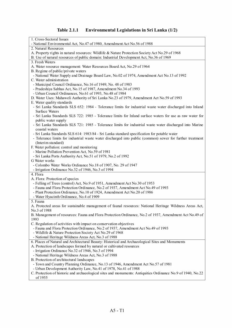
A5 - T1
Table 2.1.1 Environmental Legislations in Sri Lanka (1/2)
1. Cross-Sectoral Issues - National Environmental Act, No.47 of 1980, Amendment Act No.56 of 1988 2. Natural Resources A. Property rights in natural resources: Wildlife & Nature Protection Society Act No.29 of 1968 B. Use of natural resources of public domain: Industrial Development Act, No.36 of 1969 3. Fresh Waters A. Water resource management: Water Resources Board Act, No.29 of 1964 B. Regime of public/private waters - National Water Supply and Drainage Board Law, No.02 of 1974, Amendment Act No.13 of 1992 C. Water administration - Municipal Council Ordinance, No.16 of 1949, No. 48 of 1983 - Pradeshiya Sabhas Act, No.15 of 1987, Amendment No.34 of 1993 - Urban Council Ordinances, No.61 of 1993, No.48 of 1984 D. Water Uses: Mahaweli Authority of Sri Lanka No.23 of 1979, Amendment Act No.59 of 1993 E. Water quality standards - Sri Lanka Standards SLS 652: 1984 - Tolerance limits for industrial waste water discharged into Inland
Surface Waters - Sri Lanka Standards SLS 722: 1985 - Tolerance limits for Inland surface waters for use as raw water for
public water supply - Sri Lanka Standards SLS 721: 1985 - Tolerance limits for industrial waste water discharged into Marine
coastal waters - Sri Lanka Standards SLS 614: 1983/84 - Sri Lanka standard specification for potable water - Tolerance limits for industrial waste water discharged into public (common) sewer for further treatment
(Interim standard) F. Water pollution: control and monitoring - Marine Pollution Prevention Act, No.59 of 1981 - Sri Lanka Ports Authority Act, No.51 of 1979, No.2 of 1992 G Water works - Colombo Water Works Ordinance No.18 of 1907, No. 29 of 1947 - Irrigation Ordinance No.32 of 1946, No.3 of 1994 4. Flora A. Flora: Protection of species - Felling of Trees (control) Act, No.9 of 1951, Amendment Act No.30 of 1953 - Fauna and Flora Protection Ordinance, No.2 of 1937, Amendment Act No.49 of 1993 - Plant Protection Ordinance, No.10 of 1924, Amendment Act No.20 of 1986 - Water Hyacinth Ordinance, No.4 of 1909 5. Fauna A. Protected areas for sustainable management of faunal resources: National Heritage Wildness Areas Act, No.3 of 1988 B. Management of resources: Fauna and Flora Protection Ordinance, No.2 of 1937, Amendment Act No.49 of 1993C. Regulation of activities with impact on conservation objectives - Fauna and Flora Protection Ordinance, No.2 of 1937, Amendment Act No.49 of 1993 - Wildlife & Nature Protection Society Act No.29 of 1968 - National Heritage Wildness Areas Act, No.3 of 1988 6. Places of Natural and Architectural Beauty: Historical and Archaeological Sites and Monuments A. Protection of landscapes formed by natural or cultivated resources - Irrigation Ordinance No.32 of 1946, No.3 of 1994 - National Heritage Wildness Areas Act, No.3 of 1988 B. Protection of architectural landscapes - Town and Country Planning Ordinance, No.13 of 1946, Amendment Act No.57 of 1981 - Urban Development Authority Law, No.41 of 1978, No.41 of 1988 C. Protection of historic and archaeological sites and monuments: Antiquities Ordinance No.9 of 1940, No.22
of 1955

A5 - T2
Table 2.1.1 Environmental Legislations in Sri Lanka (2/2)
7. Noise, Vibrations and Odors A. Standards on noise, vibrations and odors: Typical Noise Level Criteria - Interim Standards B. Prevention and control of noise, vibrations and odors - Municipal Council Ordinance, No.16 of 1949, No. 48 of 1983 - Predeshiya Sabhas Act, No.15 of 1987, Amendment No.34 of 1993 - Urban Council Ordinances, No.61 of 1993, No.48 of 1984 8. Hazardous and Solid Wastes A. Hazardous and solid wastes policy/management - Industrial Products Act, No.18 of 1949, Amendment Act No.69 of 1961 - Factories Ordinance No.45 of 1942, Amendment Act No.32 of 1984 - Predeshiya Sabhas Act, No.15 of 1987, Amendment No.34 of 1993 B. Recovery treatment and disposal operations - Industrial Dispute Act, No.43 of 1950, Law No.53 of 1973 - Industrial Promotion Act, No.46 of 1990 - Industrial Products Act, No.18 of 1949, Amendment Act No.69 of 1961 - Predeshiya Sabhas Act, No.15 of 1987, Amendment No.34 of 1993 9. Prevention and Control of the Environmental Effects of Public Works - National Dangerous Drugs (Control) Board Act, No.11 of 1984, Amendment Act No.21 of 1990 - Nuisances Ordinance, No.15 of 1862, No57 of 1946 - Wells and Pits Ordinance, No.27 of 1884, No.3 of 1946 - Municipal Council Ordinance, No.16 of 1949, No. 48 of 1983 - Predeshiya Sabhas Act, No.15 of 1987, Amendment No.34 of 1993 - Urban Council Ordinances, No.61 of 1993, No.48 of 1984 10. Settlement of Disputes A. Ombudsman: Ombudsman Act, No.17 of 1981 B. Arbitration: Arbitration Ordinance, No.15 of 1866, Amendment Ordinance No.2 of 1889 11. Environmental Impact Assessment System - National Environmental Act, No.47 of 1980, Amendment Act No.56 of 1988 - Government gazettes (Extra-ordinary) No. 772/22 of 24th June 1993 and No. 859/14 23rd Feb. 1995 - A Guide for Implementing the EIA Process, No.1, 1998 - A Guide for Implementing the EIA Process, No.2, 1995 - Guidelines for conducting environmental scoping
Source: Index to Environmental Legislations in Sri Lanka, 1995 and A Guide for Implementing the EIA Process, No.1, 1998

A5 - T3
Table 2.1.2 Check List of Resettlement and Prescribed Undertakings on the Proposed Plans
Items
Proposed Measures
Possibility of Resettlement
Possible Project Type Prescribed
for IEE/EIA* 1. Ja Ela Basin Storm Water Drainage Plan 1) Ja Ela Channel Improvement A, B, C, D, F
2) Dandugam Oya Channel Improvement A, B, C, D, F
3) Ja Ela Retention Area Conservation A, B, C, D, F
4) Muthurajawela Marsh Flood Plain Conservation A, B, C, D, F
2. Kalu Oya Basin Storm Water Drainage Plan 1) Kalu Oya Channel Improvement A, B, C, D, F
2) Old Negombo Canal Improvement A, B, C, D, F
3) Urbanized Area Storm Water Retention Facilities Construction A, B, C, F
4) Kalu Oya Retention Area Conservation A, B, C, D, F
5) Muthurajawela Marsh Buffer Zone Conservation A, B, C, D, F
3. Greater Colombo Basin Storm Water Drainage Plan 1) Madiwela South Diversion Construction A, B, C, D, F
2) Mutwal Tunnel (Existing) Restoration A, D, E, F
3) New Mutwal Tunnel Construction Project A, D, E, F
4) Urbanized Area Storm Water Retention Facilities Construction A, B, C, F
5) Kolonnawa Marsh Retention Area Conservation A, B, C, D, F
6) Kotte Marsh Retention Area Conservation A, B, C, D, F
7) Heen Marsh Retention Area Conservation A, B, C, D, F
4. Bolgoda Basin Storm Water Drainage Plan 1) Weras Ganga Improvement A, B, C, D, F
2) Urbanized Area Storm Water Retention Facilities Construction A, B, C, F
3) Bolgoda Lake North Retention Area Conservation A, B, C, D, F
4) Bolgoda Lake South Retention Area Conservation A, B, C, D, F
Note: Possibility of Resettlement - : high possibility due to existence of settlements in the proposed site,
: low possibility
: no resettlement occur. *: Government gazettes No.772/22 of 24thJune 1993 and No.859/14 of 23rd Feb.1995 Prescribed project types and locations relevant to the proposed plans based on the above gazettes
A: All river basin development and irrigation projects excluding minor irrigation works B: Conversion of forests covering an area exceeding 1 hectare into non-forest uses C: Clearing of land areas exceeding 50 hectares D: Resettlement E: All tunneling projects F: Following areas
a. Within 100m from the boundaries of or within any area declared under - the National Heritage Wilderness Act No.3 of 1988; - the Forest Ordinance; b. Within the following areas whether or not the areas are wholly or partly within the Coastal Zone:
i. any erodable area declared under the Soil Conservation Act. ii. any Flood Area declared under the Flood Protection Ordinance and any flood protection area declared under the Sri
Lanka Land Reclamation and Development Corporation Act, 15 of 1968 as amended by Act, No.52 of 1982. iii. 60 meters from the bank of a pubic stream as defined in the Crown Lands Ordinance and having a width of more then
25 meters at any point of its course. iv. any reservation beyond the full supply level of a reservoir. v. any archaeological reserve, ancient or protected monument as defined or declared under the Antiquities Ordinance. vi. any area declared under the Botanic Gardens Ordinance. vii. within 100 meters from the boundaries of, or within, any area declared as a Sanctuary under the Fauna and Flora
Protection Ordinance. viii. within 100 meters from the high flood level contour of, or within, a public lake as defined in the Crown Lands
Ordinance including those declared under section 71 of the said Ordinance.

Figures

A5 - F1
JAPAN INTERNATIONAL COOPERATION AGENCY
Figure 1.2.1 Locations of Environmental Protected Areas
The Study on Storm Water Drainage Plan for the Colombo Metropolitan Region
in the Democratic Socialist Republic of Sri Lanka
Muthurajawela Marsh
Negombo Lagoon
Sri Jayawardenapura Kotte Marsh
Bellanwila-Attidiya Marsh
Settlements Surveyed
Rivers
Roads
Train
Watershed Boundaries
Study Area
Bunds
Major Cities
Railway Stations
7 10’ N
7 N
6 50’ N
6 40’ N
79 50’ E 80 E 80 10’ E

A5 - F2
JAPAN INTERNATIONAL COOPERATION AGENCY
The Study on Storm Water Drainage Plan for the Colombo Metropolitan Region
in the Democratic Socialist Republic of Sri Lanka
Figure 2.1.1
EIA Process
Note: Bracketed figures indicate maximum number of days to complete necessary procedure. Source: This figure is rearranged based on the “Guide for Implementing the EIA Process, No.1, 1998.
Central Environmental Agency, Sri Lanka”.
AppealNotice to Public
days)
(14 days)
Information
Scoping
IEE or EIA?IEE required EIA required
Preliminary Information
Accepted as IEE
Set TOR
Preparation
of IEE Report
Public Notice
Forward Comments toProject Proponent (PP)
Response to
Comments by PP
Decision
Approvedwith Conditions
Not Approved
Set TOR
Preparation
of EIA Report
Adequacy of
Report
NoFurther
Information Yes
No
Yes
(IEE: 6 days, EIA: 30 days)
(6 days)
(30 days)
(30
(6 days) Preliminary


