20
| Date post: | 28-Mar-2016 |
| Category: |
Documents |
| Upload: | cradle-coast-authority |
| View: | 212 times |
| Download: | 0 times |

Cradle Brochure Doc 1 12/7/06 3:00 PM Page 1

Cover photo: Murchison Highway Photo credits: Spirit of Tasmania, Mark Seaton (on behalf of TasPorts), Circular Head Council, Department of Infrastructure, Energy and Resources, Tourism Tasmania.
Cradle Brochure Doc 1 12/7/06 3:00 PM Page 2

FOREWORD
The Cradle Coast Region is situated on the North West and West Coast of Tasmaniaand comprises the nine local government areas of Burnie City, Central Coast,Circular Head, Devonport City, Kentish, King Island, Latrobe, Waratah-Wynyard andWest Coast Councils.
The Region covers approximately one third of the total area of Tasmania andcontains around 22.6% of the State’s population. Around 75% of the population livesalong the urban coastal strip between Devonport and Wynyard, with remotersettlements on the West Coast and King Island. Agriculture, mining, forestry andmanufacturing are major economic sectors. Tourism is becoming increasinglyimportant, focused on the Region’s significant natural and cultural heritage areas,including wilderness World Heritage Areas, extensive forests and coastline, oldmining towns and productive agricultural landscapes.
The transport system plays a critical role in strengthening the Region’s naturaladvantages, supporting the development of new opportunities and maintainingquality of life. A strategic approach that addresses current and emerging issues, andresponds to future pressures impacting on the Region’s transport system, is required.
The Cradle Coast Integrated Transport Strategy, jointly developed by the TasmanianGovernment and Cradle Coast Authority, representing the nine local governments,provides a coordinated and strategic framework to address transport issues over thecoming twenty years. It identifies regional objectives, strategies and outcomes thatwill contribute to an integrated, safe, accessible and efficient transport system thatmeets the needs of the Region’s communities and industry.
The Strategy addresses all major transport modes, including road, rail, sea and air,public passenger transport, freight movement and non-car based transport. It isinformed by wide community, industry and key stakeholder consultation, andunderpinned by a successful partnership approach.
The Region and its transport system are complex and dynamic. In this context, theStrategy does not aim to address every transport issue facing the Region. Its focus ison providing a solid and strategic foundation for developing cooperative transportresponses as issues and needs emerge over the coming decades.
The Tasmanian Government, Cradle Coast Authority and member local governmentsare committed to furthering the Strategy, and will use their best endeavours toimplement the Strategy as resources, opportunities and priorities allow.Collaborative mechanisms have been identified to monitor progress inimplementation and ensure the Strategy remains current in relation to new andevolving initiatives and opportunities.
We encourage you to investigate the issues and strategies identified within theStrategy, which will contribute to an improved and responsive transport system forthe Cradle Coast Region.
Jim Cox Roger JaenschMinister for Infrastructure Cradle Coast Authority
The Cradle Coast Authority represents the nine local governments of Burnie City,Central Coast, Circular Head, Devonport City, Kentish, King Island, Latrobe,Waratah-Wynyard and West Coast.
3
Cradle Brochure Doc 1 12/7/06 3:21 PM Page 3

Cradle Coast Authority
The Cradle Coast Authority was created
in February 2000 by the Burnie City,
Central Coast, Circular Head,
Devonport City, Kentish, King Island,
Latrobe, Waratah-Wynyard and
West Coast local governments.
Its primary role is to identify priorities for
sustainable development of the Region,
its community and economy, and to broker
partnerships between different levels of
government, industry and community
groups to address these priorities on a
regional scale. The Authority is engaged
in a range of initiatives including tourism,
natural resource management,
industry and infrastructure development.
The Cradle Coast Integrated Transport Strategyis a joint project between the Department ofInfrastructure Energy and Resources (DIER) andthe Cradle Coast Authority (CCA), representingthe nine councils of the Region. It is an initiativeunder the Cradle Coast Partnership Agreement.
The Strategy identifies objectives and outcomesassociated with key, long-term issues, andprovides a framework for managing anddeveloping the transport system over a 20-yearperiod. The Strategy has been developedcollaboratively under the auspices of a jointCCA and State Government Working Group.
Supporting activities have includedconsolidation of the findings of previous reports; analysis of regional characteristics and transport system issues and opportunities; a survey of transport users and providers; andstakeholder workshops.
The Strategy is precededby a short introduction,
which describes the overriding
objective of the Strategy, context for its
development and future implementation
processes and activities.
The Strategy focuses on four key issues:strategic transport
system, transport andindustry, land use and
transport planning, andprinciples and prioritiesfor transport investment.
Each issue is supported by a
specific objective, background
description andimplementation plans.
Content andOverview
StrategicObjectives
ImplementationPlans
StrategicObjectives
Strategic Issues
4
Cra
dle
Co
as
t|
Inte
gra
ted
Tra
nsp
ort
Str
ate
gy
20
06
Cradle Brochure Doc 1 12/7/06 3:01 PM Page 4

Transport objectivesSocial, economic and environmental objectives provide the context for the Strategy.The key transport objective is:
A seamless, cost effective and efficient systemfor moving people, goods and resourcesoperating within broader networks that:
� improves interaction and physicalconnectivity;
� enables communities and industries tomeet their transport needs; and
� enhances the Region’s and Tasmania’seconomic development, and social andenvironmental wellbeing.
Strategic IssuesThe Strategy focuses on key regional needs andissues. It does not attempt to address everytransport issue facing the Region, issues beingdealt with via other processes, or mattersbeyond the scope of the Strategy.
Some issues raised during development of theStrategy, including port management structures,King Island shipping and aviation, and core publicpassenger routes, are addressed in a companionreport. This report provides detailed supportinginformation and analysis to the Strategy.
Implementation and StewardshipIn agreeing to the Strategy, the StateGovernment, CCA and Councils signal theircommitment to work collaboratively to furtherthe objectives and principles of the Strategy.
Many strategies and actions are not funded orprogrammed into organisational work plans, andsome require collaboration with industry andgovernment corporations. The StateGovernment, CCA and Councils will use theirbest endeavours to implement the Strategy asresources, opportunities and priorities allow.
The implementation strategies contained withinthe Strategy are not listed in any order of priority.It is important that the Strategy is actively used inthe ongoing management and development ofthe transport system. The following mechanismswill assist in achieving this:
� Every 18 months, a joint implementationreport will be prepared for consideration bythe Minister for Infrastructure, and the CCA.
� The Working Group will continue to meetperiodically to monitor progress of theStrategy, including developments in other
programmes, projects and activities thatrelate to or impact on the Strategy.
� DIER and the CCA will take joint stewardshipof the Strategy and establish periodic andspecific forums to pursue strategiesadvocated within.
� DIER, the CCA and Councils will collectivelypursue mechanisms to administer the Strategywithin AusLink or other Federal or Stateframeworks as appropriate, and generallypursue integrated regional transport planning.
Three years after initial agreement to theStrategy, the CCA and DIER shall review theStrategy to determine:
� if it has been successful in establishingcoordinated actions and setting directionsthat improve transport outcomes;
� if the issues addressed and strategiesadvocated remain relevant;
� what the emerging transport issues andopportunities are; and
� whether a new, integrated transport strategyshould be prepared.
Strategies to address transport issues and needs, Cradle CoastIntegrated Transport Strategy
Strategic directionsObjectives over a longer, 20 year timeframe.
Agreed principlesCommon principles guiding thedecision making of parties withinexisting processes.
Operational actionsRecommended improvements tocurrent operational activities.
Plans and processesIdentification of new plans andprocesses which will improve transportoutcomes and management andinvestment decisions.
Infrastructure prioritiesIdentification of long term infrastructurepriorities - based on key strategic gapsand emerging and potential needs.
Communication and coordinationRecommended means of improving working relationships and collaborative actions.
5
Cradle Brochure Doc 1 12/7/06 3:01 PM Page 5
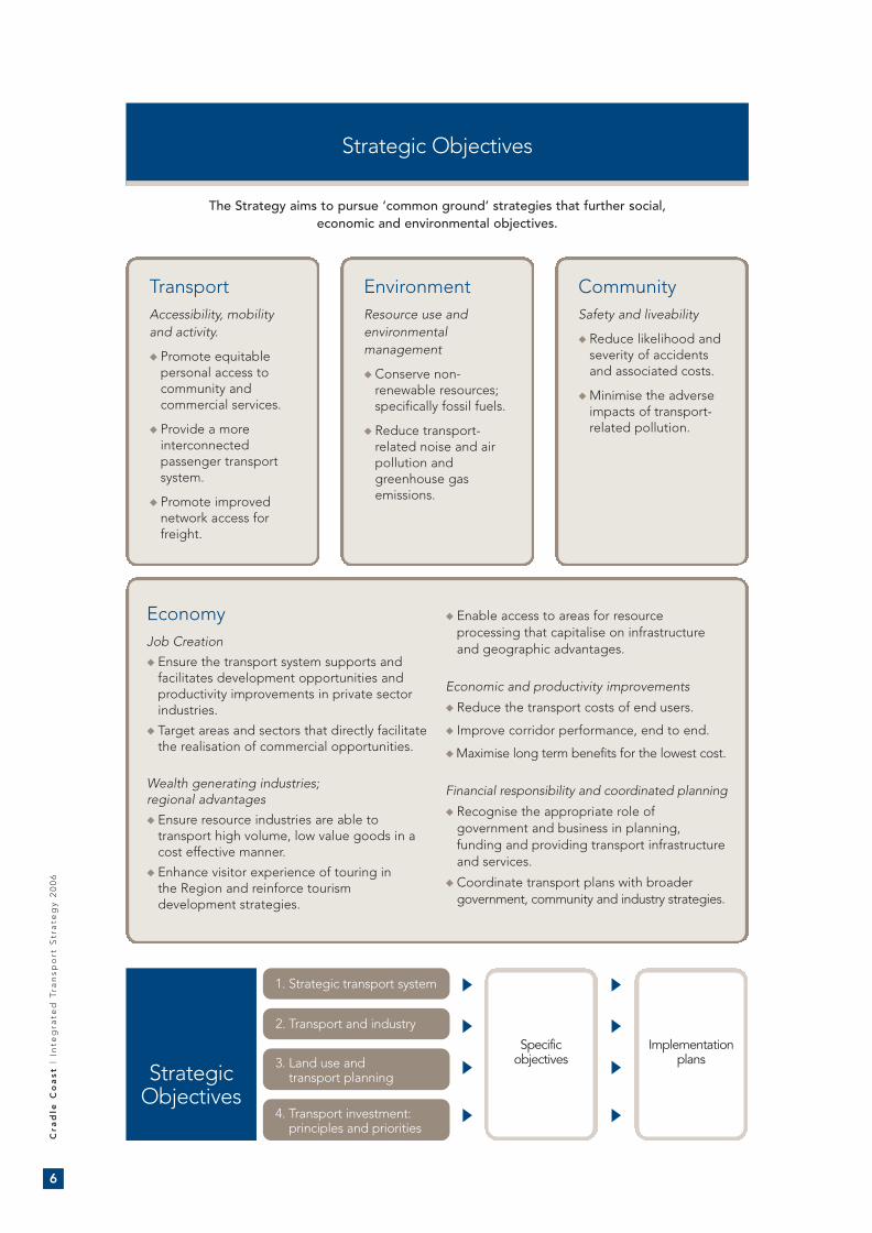
Strategic Objectives
TransportAccessibility, mobility and activity.
� Promote equitablepersonal access tocommunity andcommercial services.
� Provide a moreinterconnectedpassenger transportsystem.
� Promote improvednetwork access forfreight.
EnvironmentResource use andenvironmentalmanagement
� Conserve non-renewable resources;specifically fossil fuels.
� Reduce transport-related noise and airpollution andgreenhouse gasemissions.
CommunitySafety and liveability
� Reduce likelihood andseverity of accidentsand associated costs.
� Minimise the adverseimpacts of transport-related pollution.
EconomyJob Creation
� Ensure the transport system supports andfacilitates development opportunities andproductivity improvements in private sectorindustries.
� Target areas and sectors that directly facilitatethe realisation of commercial opportunities.
Wealth generating industries; regional advantages
� Ensure resource industries are able totransport high volume, low value goods in acost effective manner.
� Enhance visitor experience of touring in the Region and reinforce tourismdevelopment strategies.
� Enable access to areas for resourceprocessing that capitalise on infrastructureand geographic advantages.
Economic and productivity improvements
� Reduce the transport costs of end users.
� Improve corridor performance, end to end.
� Maximise long term benefits for the lowest cost.
Financial responsibility and coordinated planning
� Recognise the appropriate role ofgovernment and business in planning,funding and providing transport infrastructureand services.
� Coordinate transport plans with broadergovernment, community and industry strategies.
StrategicObjectives
Specificobjectives
Implementationplans
1. Strategic transport system
2. Transport and industry
3. Land use and transport planning
4. Transport investment: principles and priorities
The Strategy aims to pursue ‘common ground’ strategies that further social, economic and environmental objectives.
6
Cra
dle
Co
as
t|
Inte
gra
ted
Tra
nsp
ort
Str
ate
gy
20
06
Cradle Brochure Doc 1 12/7/06 3:01 PM Page 6

Strategic issue 1 Strategic Transport System
BackgroundThe efficiency and effectiveness of the Region’stransport system is significantly affected byinteraction across modes, and is largely directedby commercial realities and economies of scale.The Region’s transport system operates as ahierarchy with some corridors, nodes, servicesand infrastructure providing core functions. The efficiency, connectivity and seamlessoperation of these regionally significantcorridors, nodes, services and infrastructureprovides the framework of the transport system.
By focusing on those elements of the transportsystem that are central to the Region’s transporttask, the Strategy aims to maximise benefits tothe community.
CharacteristicsThe Region’s strategic transport system consistsof a network of linear infrastructure, ports andairports, and a range of transport services andmodes. Collectively, these elements cater for thetransport and access needs of the Region’scommunities and industry within the context ofstate, national and global transport systems.
Key characteristics of the Region’s transport system are:
� Major road and rail corridors along the North-West Coast linking major populationcentres, ports and industrial areas.
� Dual marine and air ports associated withBurnie and Devonport.
� Highways linking the West Coast to theNorth-West Coast and Hobart.
� Metropolitan bus services centred on Burnieand Devonport.
� Regular public passenger services linkingmajor towns with the urban areas, and thenorth and south of the State.
� The importance of air and sea services andinfrastructure to King Island.
� Minor port facilities at Stanley and Port Lattaand minor airports at Smithton and Strahan.
Tasmania’s State Road network is based on ahierarchy, which provides a strategic approachto road planning, investment, construction andmaintenance. The hierarchy applies to StateRoads only and consists of five categories, indecreasing order of priority, from Category: 1 (Trunk Road), 2 (Regional Freight Road), 3(Regional Access Road), 4 (Feeder Road) and 5 (Other Roads) (for an expanded definition, see Supporting Information Report, pp 77).
Strategic transport system and linkages,Cradle Coast Region
7
Cradle Brochure Doc 1 12/7/06 3:01 PM Page 7

Specific Objective
To enhance and better use transport corridors, nodes and services that provide a core function to people and businesses interacting within the Region, between regions,
and with interstate and international destinations.
Implementation Plans
� Centrally located bus stops within major cities and towns; improvedpedestrian and cycle links; a high level of comfort and security for users.
� More flexible and responsive use of passenger transport to cater forthe access needs of rural and remote communities, including betteruse of community transport services.
� Provision of safe and convenient road conditions for cyclists along theBass Highway separated, wherever practicable, from arterial trafficthrough wide sealed shoulders and on-road cycle lanes.
� Development of off-Highway cycle routes and paths, where appropriate.
� Encourage the uptake of an additional WAT license in Devonport and investigate the feasibility of introducing further WAT vehicles intothe Region.
� More informed decision making about road and rail maintenanceexpenditure levels based on factual information and assessment oflong term costs and benefits.
� Identify all significant road and rail corridors within a functionalhierarchy to improve integrated planning.
� Incrementally develop State Roads in accordance with functionaldesign targets, with priority given to Category 1-3 roads.
� Identify priority road projects on the Category 2-3 roads betweenBurnie and Queenstown.
� Work with industry to identify bridge strengthening/replacementprojects that enable more productive use by road freight.
� Clarify the State Government’s role in rail freight planning andinvestment in consultation with regional industry users.
� Improve community awareness of social, economic and environmentalbenefits of higher productivity vehicles.
� Improve road safety through local, community-driven solutions andprocesses.
� Focus on user safety in all road projects, including consideration of theneeds of all road users in project planning and design.
� Improved knowledge of practical means of implementing safetyobjectives on rural roads.
� Concentration of future West Coast airport infrastructure at Strahan.
� Transfer of Smithton airport to a commercial owner.
� Review ownership of the port access road on the eastern side of thePort of Devonport from local government to State ownership inexchange for other assets.
� Improved infrastructure and arrangements for container movements byrail from the eastern section of the Port of Devonport.
Passenger Transport and Accessibility
Linear TransportInfrastructure
Road Use and Safety
Marine and Aviation
8
Cra
dle
Co
as
t|
Inte
gra
ted
Tra
nsp
ort
Str
ate
gy
20
06
Cradle Brochure Doc 1 12/7/06 3:01 PM Page 8

Strategic issue 2 Transport and Industry
BackgroundIndustry is a key driver of the Region’s transporttask. The transport system should:
� enhance the ability of industries to accessnatural resources;
� provide for the transport of high-volume, low-value goods in a cost effective manner;
� act as the link between exporters andoverseas markets;
� enhance visitors’ experience of touring in the Region and reinforce tourismdevelopment strategies; and
� provide access to resource processing areasthat capitalise on infrastructure andgeographic advantage.
There are direct flow on effects to other areas ofthe economy from transport strategies that targetthe needs of wealth generating industries that aremost directly affected by the transport system.
CharacteristicsThe Region has a diverse range of wealthgenerating industries, including:
� Agricultural production and processing,particularly dairy, vegetable and crop. TheRegion contains the majority of Tasmania’sprime agricultural land; is the State‘s primaryvegetable growing area; and supports animportant dairying industry.
� Forestry and forest processing. The Regioncontains large areas of State and privatenative and plantation forests. Forestprocessing sites include Smithton,Hampshire, Somerset, Wesley Vale andBurnie. Forestry Tasmania has established awood merchandising/processing yard atSmithton. The transport implications for theRegion of a proposed pulp mill at Bell Bayneed to be considered when appropriate.
� Mining. The State’s mining activity isconcentrated in the Region, with mines atSavage River, Henty, Corinna, Rosebery,Renison, Mt Lyell and near Trial Harbour.Smaller mines/quarries are located inSmithton, Railton, Ridgley, Calder, and Nook.Major mineral processing sites includeAustralian Bulk Minerals (Port Latta) andCement Australia (Railton).
� Specialised manufacturing. Majormanufacturing firms include AustralianWeaving Mills, Tascot Templeton Carpets,Caterpillar Elphinstone and Vestas.
� Natural and cultural-based tourism. The Region contains some of Tasmania’s majortourist centres including Cradle Mountain,Strahan, Burnie/Devonport, and Stanley. The Region has a natural advantage in thetouring and nature-based tourism markets.
Major transport and industry networks,Cradle Coast Region
9
Cradle Brochure Doc 1 12/7/06 3:01 PM Page 9

Specific Objective
A transport system that is responsive to emerging industry trends and growth opportunities, and which enhances the competitiveness of industry, particularly the forestry, mining, tourism
and resource processing sectors, within which transport is a critical element.
Implementation Plans
� Improved planning and investment in the forestry freight network,catering to increased plantation harvesting activity and processingoperations through:
� Identification of current and future plantation areas and harvestingtimeframes;
� Identification of existing and future haulage routes;
� Development of a strategic forestry road/rail network for harvestedtimber; and
� Costing, evaluation and prioritising of infrastructure investment works.
� Assessment of transport needs and solutions at the earliest stages ofdevelopment of new mining activities.
� Continued implementation of the Cradle Coast Touring Route Strategythrough reinforcement of the role and function of identified touringroutes and hubs in transport planning.
� Implementation of the associated Cradle Coast Authority TouringRoutes and Facilities audit.
� Improved understanding of trends in tourist vehicle road use, includingvolumes, types and routes, and the consequences for road design.
� Improved management and control of commercial activities andinfrastructure development that impacts on scenery adjacent to majortourist routes.
� Improved, strategic provision of roadside facilities, including lookoutsand rest areas, which enhance visitor experience of the Region andbetter cater to visitor needs.
� Consistent advice to tourism operators to promote the location oftourism activities to:
- reinforce synergies; and
- limit impacts on major arterial roads.
� Integration of transport implications and requirements throughout the planning and assessment process associated with the developmentof industrial sites in the Devonport, Latrobe and Kentish localgovernment areas.
� Capitalise on the transport benefits of Port Latta for major industry, andfurther assess transport infrastructure options and requirements.
Forestry and Mining
Tourism
Industrial Areas
10
Cra
dle
Co
as
t|
Inte
gra
ted
Tra
nsp
ort
Str
ate
gy
20
06
Cradle Brochure Doc 1 12/7/06 3:01 PM Page 10

Strategic issue 3 Land Use and Transport Planning
BackgroundTransport networks provide for movementbetween activities, whilst the adequacy of atransport network influences settlement patternsand the location of economic enterprises.
Accessibility for individuals, families andcommunities is a key objective of any transportsystem. Accessibility means the ability to reach alocation within an acceptable amount of time,money and effort.
The majority of the Region’s population livesalong a linear coastal strip on the North-WestCoast, which contains the Region‘s core urbanareas. However, the Region also containsimportant rural and remote settlements to whichthe provision of efficient and cost-effectivetransport services is important.
Appropriate land use planning is required tomaintain and improve the strategic functionsand efficiency of key corridors and infrastructure.
CharacteristicsThe Region’s land use and transport system hasthe following characteristics:
� 75% of the population is located along alinear, coastal strip linked by a Category IHighway. The strip is characterised by the‘twin cities’ of Devonport and Burnie, adevelopment pattern that may inhibit theeconomies of scale associated with thedevelopment of major regional services andinstitutions.
� A large number of small, inland ruralsettlements with strong connections to themain urban system.
� Remote settlements on the West Coast andKing Island.
� Strategic transport corridors andinfrastructure, including major trading ports,arterial roads, airports and a main line railway.
� All areas and industries have access tocommercially provided land, sea and airfreight services.
� The regular public bus services in the twomain urban regions have significant sparecapacity.
While most commercial and residential activity islocated within the Region’s urban areas, asignificant percentage of primary income isproduced in the rural and remote areas.
Economic activity within these rural and remoteareas is dependent on the efficient operation ofthe urban transport network; for example,access to ports.
Transport network and settlement patterns,Cradle Coast Region
Strategic roads
Strategic rail
Trading ports
Strategic airpor
Urban strip
Remotesettlements
Urban buses
Strategic roads
Strategic rail
Trading ports
Strategic airports
Urban strip
Remotesettlements
Urban buses
11
Cradle Brochure Doc 1 12/7/06 3:01 PM Page 11

To provide for an integrated land use and transport planning system that:
- caters for the needs of all transport users in urban, rural and remote localities;
- is socially, economically and environmentally sustainable;
- actively ‘manages’ settlement patterns and forms to encourage the right activitiesin the right locations; and
- promotes safe and efficient freight movement through the location of industry inareas with appropriate transport services and infrastructure.
Specific Objective
Implementation Plans� Planning around major transport nodes (e.g. ports) should preserve
adjacent land for compatible use and development and limit sensitiveor conflicting activities.
� Category 1-3 roads located outside townships will be protected fromnew accesses that compromise safety and efficiency.
� Sensitive uses will be setback or modified to prevent impacts from 24-hour road and rail freight operations.
� Utilise development contributions from the initiator and users of newactivities generating demand for public transport infrastructure.
� Total transport costs will be assessed by local and State governmentswhen considering major land use changes.
Land use strategies and planning schemes should:
� Consolidate residential activities in existing urban areas and encouragehigher density housing in areas close to commercial & community services.
� Provide rural residential housing in areas close to towns and which do notgenerate demand for transport infrastructure or service improvements.
� Locate retail, high-density employment and high intensityentertainment activities in urban centres with good public transportaccess, cycling and pedestrian linkages.
Transport and industry planning should:
� Protect and promote industrial areas with good access to the road andrail network (e.g. Hampshire) for activities that have a significanttransport task.
� Ensure general industrial areas cater for, and give preference to,industrial activities that have a legitimate need for land, freightmovement and separation from other land uses.
� Ensure suitable areas are available at a regional level for majorprocessing industries that have an existing or planned access to thestrategic road or rail network as well as other economic infrastructure.
Consistent mechanisms will be developed to:
� Protect strategic marine and air ports, road and rail assets;
� Provide certainty for future transport corridors; and
� Protect airports from incompatible activities.
� Land use and transport planners will convene periodic forums toanalyse regionally significant issues and trends, and develop a regionalplanning statement/strategy to inform planning schemes.
Strategic Infrastructure
Funding
Settlement and Activity Location
Transport and Industry
Consistent Tools
Communication
12
Cra
dle
Co
as
t|
Inte
gra
ted
Tra
nsp
ort
Str
ate
gy
20
06
Cradle Brochure Doc 1 12/7/06 3:01 PM Page 12
Strategic roads
Strategic rail
Trading ports
Strategic airports
Urban strip
RemoteSettlements
Potential/proposedindustrial area
Mining
Forestry
Tourism cluster
Tourismtransport hub
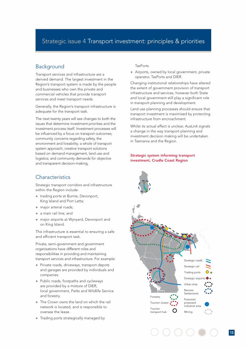
Strategic issue 4 Transport investment: principles & priorities
BackgroundTransport services and infrastructure are aderived demand. The largest investment in theRegion’s transport system is made by the peopleand businesses who own the private andcommercial vehicles that provide transportservices and meet transport needs.
Generally, the Region’s transport infrastructure isadequate for the transport task.
The next twenty years will see changes to both theissues that determine investment priorities and theinvestment process itself. Investment processes willbe influenced by a focus on transport outcomes;community concerns regarding safety, theenvironment and liveability; a whole of transportsystem approach; creative transport solutionsbased on demand management, land use andlogistics; and community demands for objectiveand transparent decision-making,
CharacteristicsStrategic transport corridors and infrastructurewithin the Region include:
� trading ports at Burnie, Devonport, King Island and Port Latta;
� major arterial roads;
� a main rail line; and
� major airports at Wynyard, Devonport and on King Island.
This infrastructure is essential to ensuring a safeand efficient transport task.
Private, semi-government and governmentorganisations have different roles andresponsibilities in providing and maintainingtransport services and infrastructure. For example:
� Private roads, driveways, transport depotsand garages are provided by individuals andcompanies.
� Public roads, footpaths and cycleways are provided by a mixture of DIER, local government, Parks and Wildlife Serviceand forestry.
� The Crown owns the land on which the railnetwork is located, and is responsible tooversee the lease.
� Trading ports strategically managed by
TasPorts.
� Airports, owned by local government, privateoperator, TasPorts and DIER.
Changing institutional relationships have alteredthe extent of government provision of transportinfrastructure and services, however both Stateand local government still play a significant rolein transport planning and development.
Land use planning processes should ensure thattransport investment is maximised by protectinginfrastructure from encroachment.
Whilst its actual effect is unclear, AusLink signalsa change in the way transport planning andinvestment decision making will be undertakenin Tasmania and the Region.
Strategic system informing transportinvestment, Cradle Coast Region
13
Cradle Brochure Doc 1 12/7/06 3:01 PM Page 13

To undertake transport investment that:
- consolidates and improves strategic transport corridors and inter-modal linkages toincrease transport efficiency;
- reflects stakeholder and community needs, including the needs of transport-dependant industries; and
- is creative and outcome focused.
Specific Objective
Implementation Plans
� Land transport investment should:
� Reinforce the existing land transport corridor hierarchy andincrementally develop State roads in accordance with the targeteddesign standards for different categories and as specific needs emerge.
� Investigate inter-modal infrastructure needs, particularly road/rail.
� Target industry development opportunities.
� Target weak links, including under-strength bridges on strategic roads.
� Significant scope exists for rail extensions that expand the market forrail operators and reduce user costs.
� Public contributions to projects may be justified where it is demonstratedthere are significant social, economic, transport system or industrydevelopment benefits; and the nature of the initial capital investmentmeans the infrastructure cannot be wholly provided commercially.
Sea and air port infrastructure investment should be made commerciallyand driven by demand whilst:
� building on the comparative advantages and characteristics of different ports;
� providing for long term investment that avoids a duplication ofinfrastructure across ports; and
� maintaining the frequency and flexibility of existing interstate air links.
� Improved life-cycle costs and asset information to enable more informeddecision-making about maintenance investment levels and priorities.
Investment processes for major projects should:
� Use cost benefit analysis and assessment techniques which fullyincorporate economic, safety, environmental and community impactconsiderations;
� Fully analyse the benefits of non-infrastructure solutions;
� Be made publicly available; and
� Focus on the best way of achieving outcomes across the whole of thetransport system.
Land Transport
Rail Extensions
Marine and Aviation
Land TransportMaintenance
Investment Process
14
Cra
dle
Co
as
t|
Inte
gra
ted
Tra
nsp
ort
Str
ate
gy
20
06
Cradle Brochure Doc 1 12/7/06 3:01 PM Page 14

Improvements to regional freight road, Smithton – Burnie/Devonport
The Bass Highway plays a critical role in connecting Circular Head communitiesto the urban areas of Burnie/Devonport, and for freight transport. Suggestedimprovements include overtaking lanes, curve realignments, road wideningand junction improvements. Concerns related to the ’Sisters Hills’ section ofthe Highway are being addressed under a joint Tasmanian and AustralianGovernment funded project to upgrade this section of the Highway. Theproject focuses on six priority projects, covering around 13km of the Highwayat 10 different locations, and provides important safety and efficiency benefits.The priority projects were identified by a joint working group comprising theTasmanian Government, Burnie, Waratah/Wynyard and Circular Head Councils,Cradle Coast Authority, RACT and the local community.
Improvements to regional freight road, West Coast – Burnie/Devonport
Critical role in connecting West Coast communities to urban services inBurnie/Devonport, for freight transport and tourist access. Improvementsthat bring the road to a Category 2-3 design standard will improve safetyand efficiency.
Key regional roadsFreight, tourist and general road use continues to grow fasteston major arterial roads.
Emerging needs and strategic gaps
Generally, the Region’s port, airport, road, rail andintermodal infrastructure adequately caters for thetransport task. However, there is a need to bettercapitalise on this infrastructure. For example,improvements to regionally significant arterialroads linking the main urban industrial area on theNorth West Coast to the far North West Coastand the West Coast, to cater for increased use byfreight, tourist and general road users.
There is also significant scope for railinfrastructure investment projects aimed atexpanding the market for rail operators andreducing costs to users.
The consultation process identified emergingneeds and strategic gaps in transportinfrastructure. Over the next twenty years, thesestrategic gaps and needs are likely to relate tothe following:
� Higher levels of road maintenanceexpenditure by road authorities to maintainservice levels.
� Continued growth in the use of major arterialroads by freight, tourist and general roadusers will generate a need for incrementalimprovements to meet road hierarchy designstandards, particularly to Category 2-3 roads.
� There is significant under-investment in themain rail line connecting ports and majorindustrial areas. Increased rail freight may see
demand for an improved alignment thatavoids coastal towns.
� Demand for new arterial freight rail lines androads is likely to be linked to major newindustrial activities that have a significanttransport task.
� Resource industries in the Region and thepotential for value-added resourceprocessing industries provide the opportunityto expand the rail freight task.
Identification of these strategic gaps and needsis aimed at highlighting opportunities to improvethe transport infrastructure serving the Region.The gaps and needs identified do not representan exhaustive, comprehensive or preferential list.
In addition, the identification of these gaps andneeds does not:
� signal any specific commitment to individualprojects by Councils, the CCA or the StateGovernment;
� diminish the role of small scale, local projectsin improving transport outcomes; or
� impact upon the identification of otherand/or future infrastructure issues, prioritiesand projects for the Region.
Identifying regionally significant multi-modalpriorities will help to ensure that investmentplanning maximises benefits to the transportsystem.
Emerging needs and strategic gaps identified through the consultation process
15
Cradle Brochure Doc 1 12/7/06 3:01 PM Page 15

Road and rail infrastructure, major processing industries, Port Latta
In terms of major industrial activities, Port Latta has infrastructure, land useand locational (e.g. on main rail line and close to Bass Hwy) advantages.
Road and rail infrastructure, major processing industries, Dulverton
The Dulverton area is suited to major processing industries due to itslocation and access to economic infrastructure. New industrial/processingactivities in both areas may generate the need for road and railimprovements and new infrastructure connections.
Road and port infrastructure associated with scheelite mine, Grassy
The existing port at the site was built to cater for previous miningoperations. It is likely that any new mining operations would generate aneed for new port and land infrastructure linkages.
Rail connection, Smithton to Wiltshire main line
The Smithton area contains critical processing industries and forestresources. The rail line currently terminates 15 km short of Smithton. The opportunity exists to extend the line closer to Smithton or theforestry areas to the south to improve rail freight options and reducetraffic on the Bass Highway.
Rail loops or duplication, Cement Australia, Railton to Devonport Port
The Cement Australia to Devonport Port rail line carries the largest freighttonnage of the main rail line. Increased freight has led to congestion anddelays in handling; a series of passing loops or a double rail line wouldincrease freight capacity and enhance the ability of rail to compete withroad transport.
Improvements to local road network to cater for plantation forestry andtransport of timber to Hampshire mill
The area south of Burnie to Waratah is a large plantation area. Most timberwill be transported using private roads to access State roads. There maybe a need to improve local roads east and west of the Hampshire mill,located in the centre of the area, to cater for the transport task.
Transport network impacts of a northern Tasmanian pulp mill
Gunns is investigating the establishment of a pulp mill at Bell Bay. Meeting the resource inputs required to support a pulp mill will createadditional transport movements to the pulp mill site by either road or rail. There is a need to strategically manage the transportation of logs acrossthe entire northern area into the longer term.
Road improvements, Arthur River - Smithon loop
Smithton and Arthur River are recognised as an emerging tourism cluster.The long term potential exists to create a loop at the end of this journey,avoiding the need for tourists to travel the same route twice. A loop couldform part of the long-term development of tourism in the area, includingimproved access to the Tarkine and Western Explorer route.
Land transport andindustrial areasNew arterial freight rail lines androads are likely to be linked tomajor new industrial activities whichhave a significant freight task.
Ports and industryThe Region’s major exportcommodities are well handledthrough existing port infrastructure.Major new resource and extractionactivities may generate a need fornew port infrastructure.
Rail freightThere has been under investment inthe main rail line connecting portsand major industrial areas.
Forest harvestingExpansion of plantations requireincreased investment in strategicrural arterial roads and road/rail logtransfer yards.
A possible northern Tasmanian pulpmill will require the transport ofhigher volumes of forest resourcesby road and/or rail.
Tourism clustersThe Region has two major tourism clusters at Cradle Mountain and Strahan, and oneemerging cluster at Stanley.
Emerging needs and strategic gaps identified through the consultation process
16
Cra
dle
Co
as
t|
Inte
gra
ted
Tra
nsp
ort
Str
ate
gy
20
06
Cradle Brochure Doc 1 12/7/06 3:01 PM Page 16

Integrated transport hub, Cradle Mountain
Continued implementation of the Cradle Tourism Development Plan,including development of a visitor village, sewerage and waterinfrastructure and transport improvements. The Plan provides for anintegrated transport hub that includes centralised carparking withtransport and visitor service options into the World Heritage Area.
Road and traffic improvements, Strahan
Suggestions include upgraded town entrance based on safety and aestheticconcerns, upgraded junctions, parking facilities and pedestrian and cyclepaths. The Esplanade provides a focus for tourism and commercial activity.Improvements that enhance mobility, safety and amenity in the area forvehicular and pedestrian traffic would be advantageous.
Rail link at Hampshire mill to transport woodchips to Burnie Port
The Hampshire mill south of Burnie is a major regional destination for forestproducts. An infrastructure gap prevents wood chips from being transportedout of the mill by rail. A short rail connection and loading facilities wouldenable woodfibre to be transported to Burnie Port.
Devonport Port container transport
The Port’s main container berths on the eastern side have only road access.The western side, which handles bulk resources, has road and rail access.The potential exists to improve the efficiency of moving containers by railand reduce the amount of road freight.
Bass Highway alignment north of Latrobe
Over the past two decades, the safety and efficiency of this section ofCategory 1 Highway has declined significantly. There is a need to identifyand protect the most suitable long term alignment between Latrobe andPort Sorell Main Road.
Tourism clustersRoad infrastructure and designimprovements that strengthen inter- and intralinkages within these clusters can enhancetransport efficiency.
Weak links and gapsOver the next 20 years, there isscope to target:
- road and rail linkages;
- rail connections to east Devonport Port;
- productivity improvements toCategories 2–4 roads; and
- under-strength bridges onstrategic roads.
Emerging needs and strategic gaps identified through the consultation process
17
Cradle Brochure Doc 1 12/7/06 3:01 PM Page 17
Currie
Grassy
Road and rail infrastructureassociated with majorprocessing industry at Dulverton.
Arthur River
Smithton
WynyardBurnie
Hampshire
Cradle Mountain
Queenstown
Strahan
Zeehan
Railton
Creation of improved loop,Arthur River to Smithton
in the long term
Improve rail connectionto Smithon/forest resources
to south of current line.
Improvements to regional freight road connectingSmithton to Burnie and Devonport.
Road and rail infrastructure associatedwith major processing industry at Port Latta.
Improvements to‘Sisters Hills’, Bass Highway.
Improvements to local roadnetwork to cater for increasedamounts of plantation timberto Hampshire.
Rail connection, Hampshire mill for transport ofwoodchips.
Improvements toregional freight road,
West Coast toBurnie/Devonport.
Improvements totourism experience,
traffic circulation,parking and roadnetwork, Strahan
Integrated transport hub,approaches to Cradle Mountain.
Bass Highway alignment northof Latrobe.
Improved useof rail for transportof containers.
Passing loops/duplicated rail line,Cement Australiaand Port.
Devonport
Road and port infrastructure,scheelite mine,Grassy.
Overview of key emerging needs and strategic gaps in regional transport infrastructure, Cradle Coast Region
18
Cra
dle
Co
as
t|
Inte
gra
ted
Tra
nsp
ort
Str
ate
gy
20
06
Cradle Brochure Doc 1 12/7/06 3:01 PM Page 18

Cradle Brochure Doc 1 12/7/06 3:01 PM Page 19

Cradle Brochure Doc 1 12/7/06 3:01 PM Page 20