SURFACE WARFARE OFFICERS SCHOOL Fact Sheet Update (September 2007) INTRODUCTION The Site Investigation (SI) phase for this site (IR Site 20), the Surface Warfare Officers School (SWOS), has been completed. BACKGROUND The SWOS site occupies approximately 90,000 square feet and was the location of the former Brig facility at NAVSTA Newport from 1951 until its demolition in 1996. It is located south of Taylor Drive and the Old Fire Fighting Training Area (OFFTA) site (Site 09) on Coasters Harbor Island. During construction of the Surface Warfare Officers School Applied Instruction Building on the site in 2003, oil was found in subsurface soils. An initial agreement was made to adopt this site into the IR Program as Study Area 20, pending the findings of the SI. PREVIOUS STUDIES A Phase I Environmental Site Assessment for SWOS Building Site was conducted in 2001 to evaluate the potential presence of oil or hazardous materials at the site. There was no visual indication or available records of environmental contamination. However, in 2003 oil was found in soils at the north portion of the site, which were uncovered during subsurface utility line installation for the SWOS Applied Instruction Building. The Navy conducted a Risk Assessment for Worker Exposure at the SWOS Site. Soil samples were collected and analyzed for total petroleum hydrocarbons (TPH) and lead. It was determined that contaminant concentrations measured did not pose an immediate threat to site occupants. RECENT ACTIVITIES A focused Site Investigation (SI) was conducted at the SWOS site to identify the source of oil contamination. Fieldwork was completed in March 2005. The draft report was provided in October 2005 and was finalized in June of 2006. The Site Investigation found oil contamination and fill in the soil within a limited area at the north end of the site under the parking area. It was found that the oil contamination is contiguous with that present at the OFFTA site across Taylor Drive to the north. The Site Investigation report recommended that the contaminants at this location be addressed with removal actions anticipated for the OFFTA site. Surface Warfare Officers School Applied Instruction Building (Constructed in 2003) NEXT STEPS The Navy has completed an administrative closeout of Study Area 20. The site will be addressed during the feasibility study phase for OFFTA Site 09.
Transcript
SURFACE WARFARE OFFICERS SCHOOL Fact Sheet Update (September 2007) INTRODUCTION The Site Investigation (SI) phase for this site (IR Site 20), the Surface Warfare Officers School (SWOS), has been completed. BACKGROUND The SWOS site occupies approximately 90,000 square feet and was the location of the former Brig facility at NAVSTA Newport from 1951 until its demolition in 1996. It is located south of Taylor Drive and the Old Fire Fighting Training Area (OFFTA) site (Site 09) on Coasters Harbor Island. During construction of the Surface Warfare Officers School Applied Instruction Building on the site in 2003, oil was found in subsurface soils. An initial agreement was made to adopt this site into the IR Program as Study Area 20, pending the findings of the SI. PREVIOUS STUDIES A Phase I Environmental Site Assessment for SWOS Building Site was conducted in 2001 to evaluate the potential presence of oil or hazardous materials at the site. There was no visual indication or available records of environmental contamination. However, in 2003 oil was found in soils at the north portion of the site, which were uncovered during subsurface utility line installation for the SWOS Applied Instruction Building. The Navy conducted a Risk Assessment for Worker Exposure at the SWOS Site. Soil samples were collected and analyzed for total petroleum hydrocarbons (TPH) and lead. It was determined that contaminant concentrations measured did not pose an immediate threat to site occupants. RECENT ACTIVITIES A focused Site Investigation (SI) was conducted at the SWOS site to identify the source of oil contamination. Fieldwork was completed in March 2005. The draft report was provided in October 2005 and was finalized in June of 2006.
The Site Investigation found oil contamination and fill in the soil within a limited area at the north end of the site under the parking area. It was found that the oil contamination is contiguous with that present at the OFFTA site across Taylor Drive to the north. The Site Investigation report recommended that the contaminants at this location be addressed with removal actions anticipated for the OFFTA site.
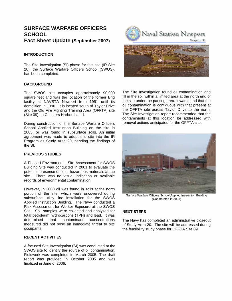
Surface Warfare Officers School Applied Instruction Building (Constructed in 2003)
NEXT STEPS The Navy has completed an administrative closeout of Study Area 20. The site will be addressed during the feasibility study phase for OFFTA Site 09.
NUSC DISPOSAL AREA Fact Sheet Update (September 2007) INTRODUCTION The NUSC Disposal Area is in the Remedial Investigation phase of the cleanup process. BACKGROUND The Naval Undersea Systems Center (NUSC) Disposal Area is located on the northwestern boundary of the Naval Undersea Warfare Center, adjacent to the Wanumetonomy Golf Club. The site was identified in the Initial Assessment Study (IAS) for Newport Sites as an area of potential contamination due to past waste disposal or handling practices. The site includes two paved storage areas, two level open field areas, and a small pond, referred to as the “Deerfield Pond” or “NUWC Pond”. The southern most portion of the site is occupied by a group of buildings used for storage of flammable liquids. In the paved storage area, two chemical disposal pits were once present, where small quantities of acids and bases from the testing labs were to have been disposed of between the 1950s and the 1960s.
Open Field at NUSC Disposal Area
Records indicate that the open fields at the site were used for the disposal of scrap lumber, tires, wire, cable, and empty paint cans for an unspecified period of time. PREVIOUS STUDIES The IAS was the first study conducted in 1983. This study identified possible fill areas but did not identify any contaminants present. During the summer of 2003, the Navy conducted a Study Area Screening Evaluation (SASE). This effort found several drums buried at the site and paint cans in a fill area near the Deerfield Creek.
PREVIOUS STUDIES (con’t) The SASE report was finalized with regulatory approval in January 2005. Based on these findings, the status was raised from a “Study Area” to a “Site”.
RECENT ACTIVITIES A background soil investigation was conducted to determine the background conditions of the soils, including naturally occurring concentrations of metals and other constituents not related to the site. A final report on the background conditions was published in September of 2006. A removal action was completed in 2005. Paint cans and associated soil as well as 35 drums of tar were found and removed from the site. The final report was issued in January of 2007.
Deerfield Pond, North of NUSC Disposal Area
NEXT STEPS A remedial investigation work plan was finalized in January of 2007. Field activities started in May of 2007 and are expected to be completed in 2008.
OLD FIREFIGHTING TRAINING AREA Fact Sheet Update (September 2007) INTRODUCTION The Navy has completed a Phase 1 Remedial Investigation, a source removal investigation, a human health risk assessment, a marine ecological risk assessment, Remedial Investigation, Feasibility Study, and initial design phases. This site is commonly referred to as Katy Field. It is IRP Site 09. BACKGROUND The 5.5 acre site adjacent to Narragansett Bay was used to train Navy personnel in fighting ship-board fires. Several buildings were present to simulate ship compartments, and these with several burning pits and paved areas served as the principal areas of activity. By 1972, most of the buildings were demolished. Two soil and debris mounds were the primary features until 2004. Based on previous investigations it was assumed that the mounds consisted mainly of demolition debris from the former training buildings and pavement. The site was used for recreation from 1974 until 1998. A child day care center was also in operation at the site until 1994. PREVIOUS STUDIES An Initial Assessment Study (IAS) was conducted in 1983 that concluded that since the area had been excavated extensively, and no environmental problem had been reported, the site did not pose any threat. However, in 1987, oil was found in the subsurface soil during work to expand a child day-care center. In 1992, the Navy initiated a Remedial Investigation (RI). The Phase 1 RI reported in 1994 that VOCs, pesticides and fuel components were present in soils and groundwater. It was determined the contaminant concentrations did not pose an immediate threat to humans. In the fall of 1996 the Navy reviewed the findings of the Phase 1 RI. A study was initiated to define possible continuing sources of oil contamination on the site. However none were found, and it was determined that the oil was likely immobile and degrading. In 1998 the EPA requested that Katy Field and the recreational area around it be closed due to elevated concentrations of metals that were reported in the 1994 RI report.
The Navy immediately performed a human health risk assessment at Katy Field which concluded that risks to site users were negligible. However, studies did report that lead was present in surface soils at a concentration in excess of the residential criteria RIDEM published in 1996. Also in 1998, an ecological risk assessment was conducted in the harbor adjacent to the site. This study found some potential for risk to ecological receptors in the near shore areas from contaminants in sediment. A Feasibility Study was completed in 2002 to evaluate remedial action alternatives to restore the site for unlimited use. Based on that study, the Navy announced intentions in July 2003 to conduct a soil removal action to remove the contaminants from the on-shore portion of the site. Also in July 2003, a fact sheet was published and an informational open house was hosted by the Navy to present plans for soil removal actions. The soil removal action commenced in 2004, and is anticipated to be continued through 2006. RECENT ACTIVITIES The Navy completed a soil and debris removal at the site in May of 2005. A fingerprinting study to identify the source of hydrocarbons near the shoreline was completed in February of 2006. An optimization study was completed during 2006. NEXT STEPS The Navy has a work plan and a signed action memo that includes subsurface soil removal, foundation demolition and removal, and construction of a revetment to protect the shoreline. The Navy will keep the public informed of progress through the Restoration Advisory Board http://www.rabnewportri.org/ and other outreach programs.
GOULD ISLAND BUILDING 32 Fact Sheet Update (April 2006) INTRODUCTION The Gould Island Electroplating Shop and Building 32 (Site 17) were demolished. The remedial investigation phase is complete. SITE HISTORY Gould Island lies between Aquidneck and Conanicut Islands, about 1.5 miles from the NSN shoreline. The site was initially defined as three small rooms in the southwest corner of Building 32 at the northeast end of Gould Island. Electroplating and degreasing operations were performed in Building 32 during the mid-1940s, when it was used to service and store torpedoes. Site 17 has expanded to include all of the Building 32 area.
Aerial Photograph of Gould Island in 1940’s PREVIOUS STUDIES Site 17 was included in the Initial Assessment Study for the base (1983). The report suggested that operation rinse water was disposed directly into the bay so that contaminated sediments might be present off shore. In 1986, a confirmation Study reported that sediment samples revealed slightly elevated concentrations of cyanide and copper. Mussels collected from the area of the rinse water out-fall contained elevated levels of copper. A Waste Inventory and Sampling Report (1992) characterized waste present in Building 32 as liquid waste containing elevated levels of cadmium and organic chemicals. As a result, in 1992, the Navy initiated a removal action to dispose of liquid and semi-liquid wastes from the plating shop area.
A work plan for a Study Area Screening Evaluation (SASE) was issued in 1992 but the project did not proceed at that time because funds were needed to address contamination at other Navy sites. In 1997, the Navy performed UST removal and closure actions near Building 32. In an agreement with the EPA and RIDEM, the Navy conducted the first phase of the SASE on all of Building 32 in 1998. This study found low concentrations of degreasing and fuel-related contaminants in the soils under the building, and the status was upgraded from a “Study Area” to a “Site”. Building 32 and the remaining structures in the area were demolished in 2001, due to the deteriorated condition of the structures. During building demolition in 2003, PCB–contaminated soils were discovered around transformer vaults near Building 32. Removal actions for these soils were completed under the Toxic Substances Control Act (TSCA). The Remedial Investigation field work was conducted in 2005, which included a full evaluation of soil, groundwater, sediment and disposal systems at the site. The Remedial Investigation report was finalized in December of 2006. NEXT STEPS A Phase II Remedial Investigation is under development. A draft is expected in November of 2007.
Former Location of Building 32
DERECKTOR SHIPYARD Fact Sheet Update (September 2007) INTRODUCTION An on-shore Study Area Screening Evaluation (SASE), and off shore investigations, risk assessments and feasibility studies have been completed for the Derecktor Shipyard site (IR Site 19). BACKGROUND The former Derecktor Shipyard is located on the waterfront at Coddington Cove. The Navy used the site along Narragansett Bay until the 1973 military realignment program when the area was no longer needed to support military activities. In 1979, the Navy leased the 41-acre site to the Rhode Island Port Authority and Economic Development Corporation, which issued a concurrent sublease to Robert E. Derecktor of Rhode Island, Inc. From 1979 to 1992, when Derecktor filed for bankruptcy, the site was used to repair, maintain, and construct private and military ships. These operations generated sand blast grit, paint, and other ship manufacturing wastes. The Navy undertook a series of short-term actions to significantly reduce the potential for contamination to pose a health or environmental risk and to migrate beyond its current location. These actions included removing contaminant-filled drums and containers, and sandblast grit; excavating and removing above ground and underground storage tanks; locating storm drain systems; and cleaning interiors of remaining buildings to ensure the safety of personnel conducting additional studies.
USS Forrestal Moored at Pier 1
PREVIOUS STUDIES A Study Area Screening Evaluation (SASE) was conducted that assessed the status of soils, groundwater, and the terrestrial ecosystem. The SASE report concluded that the site contained small pockets of soil contamination but that overall human and ecological risks were not substantial for industrial use. Concurrent with the SASE, the Navy conducted a marine ecological risk assessment and human health risk assessment to quantify how contaminants present in bay sediments might be affecting plants and animals, as well as subsistence fishermen collecting shellfish from the site. A Feasibility Study (FS) was conducted in 1999 for the marine areas near the site. The FS recommended limited dredging of sediments from the pier areas to reduce human and ecological risks. Also In 1999, the Navy implemented the recommendations for on shore restorations, including removal of soil hot spots, removal of an underground septic vault, and demolition of some of the deteriorating buildings. RECENT ACTIVITIES In 2004, marine sediment sampling was conducted to update the Navy’s understanding of the condition of the sediments. Data results were evaluated and found that while contaminant presence was stable, new sediments were covering the old sediments. NEXT STEPS A draft feasibility was completed in March of 2007 that re-evaluated the remedial alternatives from the FS (feasibility study) conducted in 1999 based on new sediment data collected in 2004. A draft Proposed Remedial Action Plan (PRAP) is expected in 2008.
McALLISTER POINT LANDFILL Fact Sheet Update (September 2007) INTRODUCTION At the McAllister Point Landfill (IR Site 01) the Navy has conducted a Remedial Investigation and Source Control Feasibility Study, constructed a RCRA C-type cap over the landfill, and performed a Management of Migration Investigation and Feasibility Study. The site is now in the long-term monitoring phase. BACKGROUND The site was used as a landfill from the mid-1950s to the mid-1970s to dispose of a variety of wastes, reportedly including domestic refuse, spent acids, paints, solvents, waste oils, PCB-contaminated transformer oils, and construction debris. From 1955 to 1970, nearly all disposed waste was burned in an on-site incinerator. Following landfill closure in the mid-1970s, a 3-foot thick soil cap was installed. PREVIOUS STUDIES The Navy conducted Phase I and II RI field work in 1993 and 1994. The Remedial Investigation report revealed that fill thickness ranges from 3 to 8 feet in the north, to 25 to 27 feet along the western portion of the landfill. Landfill material is composed of municipal and industrial waste (plastic, wood, paper, cloth, garbage, and construction debris) with a layer of ash (from the on-site incinerator) present in the north-central portion of the site. A human health risk assessment was performed in 1997 for the shoreline and marine environment near the landfill. This assessment found unacceptable risks to humans ingesting contaminated shellfish (mussels and clams) that were present at the site.
An ecological risk assessment (1997) was conducted to determine the impact of sediment erosion from the shoreline seaward of the landfill cap on the bay. This study identified high potential for risk to ecological receptors at several near shore areas. In 1995 and 1996, the Navy constructed a RCRA C-type cap for the landfill to reduce contaminant leaching and transport. Five year reviews of this remedy were conducted in 1999 and 2004 to assure it is still protective. A Feasibility Study was completed in 1998 that evaluated remedial alternatives to reduce risk to receptors in the marine environment near the landfill. A Record of Decision (ROD) was prepared and signed that described the recommended remedial alternative: Dredging the most contaminated sediment, and monitoring the offshore area to the south and west of the landfill. The remedial action construction was completed in December 2001.
RECENT AND CONTINUED ACTIVITIES Periodic monitoring of groundwater and landfill gas emissions has been on-going since completion of construction actions. These efforts, along with long term monitoring of sediment initiated in 2004, will be conducted in accordance with state and federal regulations to assure the remedy is protective. Habitat mitigation efforts in the offshore area of the site to promote eelgrass growth was completed in 2006.
MELVILLE NORTH LANDFILL Fact Sheet Update (September 2007) INTRODUCTION The Navy has completed a cleanup consistent with the State of Rhode Island procedures (as opposed to CERCLA process) for cleanup, with agreement from the USEPA at this site (IR Site 02). The state-guided investigation and report documenting the study findings compressed several activities, enabling the Navy to complete those tasks more rapidly than under the federal program. BACKGROUND The Melville North Landfill received domestic refuse as well as spent acids, waste paints, solvents, waste oils, and PCBs. The site was excessed in 1989, and is now privately-owned. The site was included in the Navy’s Initial Assessment Study (1983), the Confirmation Study (1985) and the Phase I Remedial Investigation (1992). Results of these studies indicated that contamination was present in soils and under still-present lagoons. Two removal actions were conducted based on the findings of the Phase I RI Report. The first was completed in 1993 and the second was completed in 1995. During the 1995 action, free petroleum was found in the soils that remained.
Soil Removal Actions, Melville North Landfill
Since the removal action in 1995, the Navy agreed to clean the site to the extent necessary for its unrestricted reuse. Construction to remove the contaminated landfill materials commenced in 1998 and was completed in 2000.
Melville North Landfill After Removal Actions RECENT ACTIVITIES The property has been excessed to Melville Marine Industries for development. However, the Navy retains responsibility for any remaining environmental issues. In 2003, the State of Rhode Island requested some follow-on groundwater quality testing. Three rounds of groundwater testing were completed in 2003 and 2004, showing chemical – specific criteria have been met, and the Navy has therefore recommended no further action. NEXT STEPS RIDEM has recommended additional groundwater monitoring due to the presence of an oil sheen on water purged from on-site wells in 2004. The Navy is continuing discussions with RIDEM on this issue.
CODDINGTON COVE RUBBLE FILL AREA Fact Sheet Update (September 2007) INTRODUCTION The Coddington Cove Rubble Fill Area (Study Area 04) is located on the west side of Coddington Highway at the Newport-Middletown town boundaries. The site was included in the Installation Restoration (IR) Program in 1992 due to recorded presence of fill on the property. BACKGROUND Study Area 04 is a small area (less than 8 acres) that was used from 1978 through 1982 for general fill. Records researched for the Initial Assessment Study (IAS) indicated that the area was used for the disposal of rubble, concrete, asphalt, slate, wood, brush, and possibly small quantities of ash. This area is located between Coddington Highway to the south and east and a railroad track running parallel to Defense Highway to the west. The site is completely vegetated and ranges from grass to thornscrub to light wooded vegetation. A stream and associated wetland also is present in this area, receiving storm water drainage from uphill to the north and east.
There is no historic environmental data available for the site and currently no activities are under way. The area is fenced and unoccupied. RECENT ACTIVITIES Historically the site has been regarded as a low priority for the IR Program. However, in May 2004, soil and groundwater samples were collected from wetland areas and from test pits excavated on the site to assure the appropriateness of this status. Data was analyzed and a brief findings report was published in 2004. The findings were presented to the Restoration Advisory Board in October 2004. These findings included presence of demolition debris and blast stone at the site, along with elevated levels of arsenic and lead in the soil. PAHs (polycyclic aromatic hydrocarbons) were present in the soil and wetland sediments as well, which are likely a result of overland runoff and storm drainage from surrounding roadways. NEXT STEPS Reports have been evaluated by the agencies and it was recommended that a Study Area Screening Evaluation (SASE) be conducted to identify any possible risks from chemical constituents at the site. However, due to the inert nature and low concentrations of the constituents found, this site remains a low priority compared to other NAVSTA sites. In the meantime, the fence around the site was repaired to prevent access until further investigations can be conducted.
MELVILLE WATER TOWER Fact Sheet Update (September 2007) INTRODUCTION The former water tower site is located on West Main Road in Portsmouth. It is adjacent to the Melville Elementary School and Navy Housing. A soil investigation determined that soil under the water tower had been contaminated with lead during maintenance painting and scraping activities. BACKGROUND Site 21, the Melville Water Tower, was location of 50,000 gallon elevated tank that provided static water pressure and a small firefighting reserve for the area including the Melville Elementary School and the Portsmouth/Melville Campgrounds. The water tower was demolished in 2006 after Navy engineers identified structurally unsound components. Blue paint chips were observed on the ground. Investigations in 2005 indicated that lead paint chips had contaminated the soil under and near the water tower. Besides lead, soil also contained arsenic, cadmium, copper, and chromium at unsafe concentrations.
RECENT ACTIVITIES The Navy completed a soil investigation in 2006. Eighty three samples were taken at 45 locations. The most highly contaminated soil was found directly under the former water tower location. Lead contaminated soil was also found up to two feet below the ground surface in four locations. A soil removal action was undertaken during the school’s summer vacation in 2007. Once removed, clean material was used to fill excavations and the area was seeded. NEXT STEPS The soil removal closeout report will be issued. It will include information on how much soil was removed, where it was removed from, where it was disposed of, and confirmatory sample results taken to verify that all contaminated material had been removed.
TANK FARMS 4 & 5 Fact Sheet Update (September 2007) INTRODUCTION Tank Farms 4 and 5 (IR Sites 12 and 13) are located on Defense Highway in Middletown and Portsmouth, RI. The tank farms have undergone extensive investigations under the IR and UST programs. The tanks on the property were demolished (i.e. imploded) in 1997 and 1998. BACKGROUND Tank Farms 4 and 5 are part of a series of five fuel depots that were used to store fuel oil for ships. Tank Farm 4 consisted of 12 underground concrete tanks, each with a capacity of 2.5 million gallons. Tank Farm 5 consisted of 11 similarly sized underground concrete tanks.
Aerial Photograph of Tank Farm 5 (1943)
These fuel tanks were constructed in the 1940s and used to fuel the ships berthed at Newport until the 1970s when the ships were assigned to other ports of call. The tanks were then used for reserve supply until the late 1980s. The tanks were cleaned and ballasted between 1994 and 1997. After cleaning was completed, the tanks were demolished by implosion. These sites were identified in the Navy’s Initial Assessment Study as potential sources of chemical contaminants. Study Area Screening Evaluations were completed that included soil and groundwater sample collection and analysis. At Tank Farm 5, two of the tanks (53 and 56) were identified as RCRA Hazardous Waste Storage Tanks since they were used between 1975 and 1980 for storage of waste oil. These tanks underwent RCRA Closure. Following the RCRA closure investigations, an interim Record of Decision (ROD) was prepared in 1992.
Between 1997 and 1998, the tanks that were no longer needed were imploded in place. The ground was re-graded and the affected areas were re-seeded.
Implosion of Tanks in 1997
A groundwater collection and treatment plant was constructed in 1994 to treat groundwater passing under and around tanks 53 and 56. The plant operated from 1994 to 1996. RECENT ACTIVITIES Groundwater quality monitoring conducted from 1998 to 2004 indicated the removal of the fuel and demolition of the tanks was effective in reducing contaminant concentrations to meet RIDEM groundwater standards for GA aquifers. Additional monitoring wells were installed and tested in the vicinity of the former waste oil tanks to evaluate the condition of groundwater in the bedrock at the request of RIDEM. The fifth round of groundwater monitoring showed acceptable conditions and the Navy has recommended no further action for the groundwater in this area. The EPA has tentatively agreed, and closure documents will be prepared pending state approval. At the request of the regulatory parties, alleged sludge disposal pits were searched for. Some oil-contaminated soils were found and removed near storm drain outfalls, though the pits were never located. This effort was completed in 2006. A report was finalized in June of 2007. NEXT STEPS A risk assessment is being developed.
Tank Farms 1, 2, and 3 Fact Sheet Update (September 2007) INTRODUCTION The Defense Fuel Support Point (DFSP) is located in Melville North portion of Portsmouth RI at the northernmost end of Naval Station (NAVSTA) Newport. The DFSP area is comprised of Tank Farms 1, 2, and 3. The DFSP tank farms abut Narragansett Bay and occupy approximately 180 acres. Tank Farms 1, 2, and 3 are named Study Areas 7, 10 and 11 as part of the Installation Restoration program for NAVSTA Newport. The Tank Farms are being cleaned-up under two separate environmental programs. The tanks and fuel oil are being managed under the state’s Underground Storage Tank (UST) Program, which governs the cleanup of oil contamination. The UST Program is mandated by the Resource Conservation & Recovery Act. Contamination associated with sludge burning pits at the Tank Farms is being managed under the Navy’s Installation Restoration (IR) Program, which governs the cleanup of hazardous substances mandated by the Comprehensive Environmental Response, Compensation, and Liability Act (CERCLA). The USEPA and the state oversee the IR Program in accordance with the Federal Facilities Agreement of 1992. The Navy is assisted by the community through a Restoration Advisory Board (RAB) http://www.rabnewportri.org.
Locations of Tank Farms 1,2, and 3
BACKGROUND The three Tank Farms 1, 2, and 3 were operating storage consisting of 16 concrete and 8 steel tanks providing a total capacity of 34 million gallons. The sites were utilized for the storage of fuel oils and disposal of tank bottom sludge. Fuels stored in these tanks include diesel oil, jet fuel, 100-octane gasoline and aviation fuel. Tank bottom sludges were burned in open pits as a means of disposal at various locations throughout the sites.
Disposal occurred at the sites from World War II until the mid-1970s. Hazardous substances may have been released as a result of this activity, thus causing the sites to be placed in the IR program. The Tank Farms are located on NAVSTA Newport property and were operated by Defense Logistics Agency (DLA) under a license agreement until February 1998. The cleanup of oil contamination and closure of the storage tanks is the responsibility of DLA. NAVSTA oversees the cleanup process and the property lease agreement. UST PROGRAM DLA completed the cleaning and closure of the tanks at all the Tank Farms in 2005. DLA is currently awaiting RIDEM closure certificates for the tanks. Historical aerial photographs were used to locate areas of potential petroleum releases back to the 1940s. Investigations and cleanup of the areas around the tanks were conducted based on this aerial photography and site history. NEXT STEPS Draft site investigation and remedial action reports were completed for Tank Farm 2 in July of 2006 and for Tank Farm 3 in January of 2006. A draft work plan for site closure of Tank Farm 1 was completed in October of 2006. The Navy has determined that the Tank Farms are underutilized, i.e. vacant or not needed to meet Navy mission. Tank Farms 1, 2, and 3 are on the Navy’s proposed excess property list.
Carr Point Shooting Range Fact Sheet Update (September 2007) INTRODUCTION The Carr Point Shooting Range, UXO Site 1, is a 2-acre portion of land located in the Melville South section of NAVSTA Newport off Burma Road in Portsmouth, RI. It is located about four miles north of the Navy fenceline at Coddington Cove. The range was closed in 1989 and is currently used as a recreational area and RV park by Navy and DOD personnel. The Carr Point Shooting Range is being investigated under the DOD’s Military Munitions Response Program under the Defense Environmental Restoration Program (DERP). The MMRP was established to address munitions and explosives of concern (MEC), including unexploded ordnance (UXO) and discarded military munitions (DMM) and munitions constituents (MC) at other than operation military ranges other sites. BACKGROUND The Carr Point Shooting Range was used as a recreational skeet range by Navy personnel from 1967 to 1973, and by the Aquidneck Island Military Rod and Gun Club from 1975 to 1989. During its use as a skeet range, clay pigeons were launched toward Narragansett Bay, and small arms were fired at the targets as they flew over the water. Targets and ammunition dropped into the water or onto the beach with shells and casing released at the firing point. Since the firing line was approximately 25 to 60 yards from the water, the majority of the lead shot is presumed to have landed in the water. The area with potential target fragment accumulation is 100 yards, while the area with potential lead shot accumulation extends to 300 yards. Since the shots were fired over water, there was not feature present to act as a backstop for spent ammunition. There were three firing points located at the site. These firing points were located along the west side of the site, facing the water. One firing point was in the northwest corner of the site; a second firing point was in the southwest corner of the site; the third was located between these two points, along the shore side of the site. The majority of skeet range facilities were removed however, no information regarding facilities decommissioning and/or soil removal has been identified for the site. The former range site was redeveloped as a recreational vehicle park circa 1990 and currently has 12 RV campsites. The former clubhouse (BLDG 233) has been converted to office and storage space for the RV park. The RV park is open from Memorial Day through
October for usage by military DOD personnel. The site is not available to the general public. Guests typically stay for three to four days at a time and are allowed to stay for a minimum of two weeks. PREVIOUS STUDIES A water area munitions study (WAMS) was completed in October of 2005. A partial firing arc at the extreme northern edge of the range was identified. In addition, clay pigeon fragments and spent shotgun casings were also discovered. A draft site investigation work plan was submitted to the regulators for approval in August of 2007. NEXT STEPS A final site investigation work plan is expected in March of 2008.