I SURVEY OF HICHWY CONSTRUCTION MATERIALS IN THE TOWN OF BALTIMORE, WINDSOR COUNTY, VERMONT prepared by Engineering Geolbgy Section, Materials Division U Vermont Department of Highways in cooperation with United States Department of Transportation Federal Highway Administration Nontpelier, Vermont Septetuber, 1972
I The work of this Project was greatly implemented by the cooperation
- and assistance of many groups and individuals. The following were partic-
ularly helpful in carrying out the Project's objectives.
I. Various departments and individuals of the Vermont State Department of Highways, notably the Planning and Mapping Division and the Highway Testing Labo-ratory.
2. Professor D. P. Stewart of Miami University, Oxford, Ohio.
3. Professor C. C. Doll, Vermont State Geologist, University of Vermont, Burlington, Vermont.
4. United States Department of Commerce, Bureau of Public Roads.
p The Materials Survey Project was formed in 1957 by the Vermont State
Department of Highways with the assistance of the United States Bureau of
Public Roads. Its prime objective was to compile an inventory of highway
construction materials in the State of Vermont. prior to the efforts of
the personnel of the Survey as described in this and other reports, searches
for highway construction materials-were conducted only as the immediate
situation required. Thus only limited areas are surveyed, and no over-
all picture of material resources was available. Highway contractors or
resident engineers are usually required to locate the materials for their
respective projects and have samples tested by the Highway Testing Labo-
ratory. The additional cost of exploration for construction materials is
passed onto the State in the form of higher construction costs. The Ma-
terials Survey Project was established to minimize or elimate this fac-
tor by enabling the State and its contractors to proceed with information
Page 2
on materials sources available beforehand. Prior knowledge of locations of
suitable material is an important factor in planning future highways.
The sources of construction materials are located by this Project
through ground reconnaissance study of maps and aerial photographs, and
geological and physiographic interpretation. iiaps, data sheets, and work
sheets for reporting the findings of the Project were designed with their
intended use in mind. These maps and data sheets were devised to furnish
information of particular use to the contractor or construction man. For
maximum benefit, the maps, data sheets, and this report should be studied
simultaneously.
Inc losures
Included in this folder are two surface-geology maps, one defining the
location of tests conducted on bedrock sources, the other defining the loca-
tion of tests conducted on granular materials. These maps are derived from
• 15-minute or 7½-minute quadrangles of the United states Geological Survey
enlarged or reduced to 1:31250 or l!t = 2604 1 . Delineated on the Bedrock
hap are the various rock types of the area. This information was obtained
from numerous sources: Vermont Geological Survey Bulletins, Vermont State
Geologist Reports, United States Geological Survey Bedrock Uaps, and the
Centennial Geological hap of Vermont, as well as other references.
The granular materials map depicts areas covered by various types of
glacial deposits (outwash, moraines, kames, kame terraces, eskers, etc.) by
which potential sources of gravel and sand may be recognized. This infor-
mation was obtained primarily from a survey conducted by Professor
D. P. Stewart of Uiami University, Oxford, Ohio, who had been mapping the
glacial features of Vermont during the summer months since 1956. Further
p
Page 3
information was obtained from the Soil Survey (Reconnaissance)
of Vermont conducted by the Bureau of Chemistry and Soils of the United
States Department of Agricultrue, and from Vermont Geological Survey Bul-
letins, United States Geological Survey Quadrangles, aerial photographs, the
Surficial Geologic hap of Vermont, and other sources. On both maps the areas
tested are represented by Identification Numbers. Several tests are usually
conducted in each area represented by an Identification Number, the number
of such tests being more or less arbitrarily determined either by the
character of the material or by the topography.
Ldso included in this folder are data sheets for both the Bedrock and
Granular i.aterials Survey, which contain detailed information for each test
conducted by the Project as well as information obtained from other sources,
and including an active card file compiled by the Highway Testing Laboratory.
The latter information was gathered over a period of years by many persons
and consequently lacks the organized approach and detail required for effec-
tive use. The information on the cards varied widely in completeness. Trans-
fer of information from the cards to the data sheets was made without elab-
oration or verification. tYhen possible, the locations of the deposits listed
in the card files have also been plotted on the maps; however, some cards in
the file were not used because the information on the location of the deposit
was incomplete or unidentifiable. Caution should be exercised wherever this
information appears incomplete. This Project does not assume responsibility
for the information taken from the card files.
Work sheets contain more detailed information on each test and a de-
tailed sketch of each identification Number Area. The work sheets and
laboratory reports are on file in the office headquarters of this Project.
Page 4
ro LOCATION
The town of Baltimore is situated in the southeast part of Vermont in
the southern part of Windsor County. Baltimore is bounded on the north and
northwest by Cavendish, on the south by Chester, and on the east by Weathers-
field. (See County and Town Outline Map of Vermont on the following page.)
Baltimore lies within the Vermont Piedmont Physiographic Subdivision, of
the New England Upland. The topography varies from steep scarps on northeast-
ward trending Hawks Mountain along the northwest border to gentle rolling hills
in the remainder of the town. Elevations range from 2,089 feet on Hawks
Mountain to about 675 feet at a point where the town line crosses an unnamed
brook approximately one quarter of a mile north of the southeast corner of
town.
Principal drainage is southward via Chandler Meadow Brook and Beaver
Meadow Brook, which flow into Great Brook in Chester; and southeastward via
two unnamed brooks which flow into Great Brook at North Springfield just be-
____\ 1010(00(1 r °000' • C 0101(1 / /1I0100000 - — /1(111(1
0 oc. 10(10000
000010 'a ssloo / •__•
/ 101*1100 u
/
• SI001& / i -'•___• i / •
• ---\ 001110*0(0 1(CoIl0(/ i 0011101
• 0(010*1 9911AIPTON'
I —
0010 OHIO, (1111(10*
1t.______/ 0*111011
0*01* ( •'a '1 0 oloi
ooiooIw / I 'aW
\ ($
-- / 00000l001,/ ar
.._,•/ / II&II1000
/' / 01*1(0000 ; ---/2.. • COU NT"( AND TOVN
• -J____.. - - • • OUTLINE MAP
• OF Stamps
• • - . 01110 , .hlI*al *tboLhlHb001 I
• • - •-:
i________L.T____l_, -• • \f E R 0
0*ILU I I
-:1 • •
*00 MI 11001 r_ r ---°"
010000 - - • I I
• • 0*01011 &M0l0(l CM(IUI
• - I i' I n4vI
I I -
o 10HIO, -
11000*10 I 0*0000 H" wio*LIL - ,J 11*100*1
0010
• I 400*100 I
• 011,0(110 ou000aouo ul11101 I ooM (o/ w(01IllO0110
• • J.--__4_.. / ''/_I - • __ •i---
a.
1100I00011 I 01010000111 ' r - i — — -• — -rQo II V
-- :- I •- I0V
• - .
'rLrJ OIH1OIO
0000l.0101 0010(010 I •
, llLIIl01011 lIl010011 - NAP
1(111101011 - -
• r—
VERMONT DEPARTMENT OF HIGHWAYS -
I • I HIGHWAY PLANNING DIVISION
figmat
- I I • ,*I1I00100 0011(00 0*110000 GCAI.1
' 'I 00•U
.•--• •.— • - - • AUGUST. 1967
SURVEY OF ROCK SOURCES
P roc edu re for Rock Lulye
The routine employed by the project in a survey of possible sources of rock
for highway construction is divided into two main stages; office and field inves-
tigations.
The office investigation is conducted primarilty during the winter months
and comprises the mapping and description of rock types as indicated in various
reference sources. Many different sources of information are utilized, as indi-
cated in the bibliography. These references differ considerably in dependabili-
ty due to new developments and studies that have contributed to the obsolescense
of a number of reports. In addition, the results of samples taken by other indi-
viduals are analyzed, and the location at which these samples were taken is
mapped when possible. In other words, as complete a correlation as possible is
made of all the information available concerning the geology of the area under
consideration.
The field investigation is begun by making a cursory preliminary survey of
the entire area. The information obtained in the preliminary survey, together
with the information assimilated in the office investigation, is employed to de-
termine the areas where testing and sampling will be concentrated. When a prom-
ising source has been determined by rock type, volume of material, accessibility,
and adequate exposure and relief, chip samples are taken with a hammer across
the strike or trend of the rock. The samples are submitted to the Katerial Test-
ing Laboratory for abrasion testing both by the Deval Method (AASHO T-3) and the
Los Angeles ]Method (AASHO T-96). It should be kept in mind that the samples
taken by the chip method are often within the weathered zone of the outcrop and
consequently may give a less satisfactory test result than fresh material deeper
in the rock structure. When the material is uniform and acceptable abrasion
tetsresult from the chip samples, the material source is included in this re-
port as being satisfactory.
Page 6
Discussion of Rock and Rock Sources
It should be noted that information on the Rock Materials Map is some-
what simplified. (For a more detailed description of the respective rock
formations, see the Summary included in t±-is report.)
Occasionally, rocks belonging to the same formation and exhibiting simi-
lar characteristics (i.e., color, texture, etc.) may produce different abrasia
results owing to different physical and chemical properties. Therefore in no
case should satisfactory test results of an area be construed to mean that the
same formation, even in the same area, will not later produce unsatisfactory
material. This is especially true of metamorphic rocks.
The town of Baltimore is mostly underlain by rocks of the Mount Holly
complex. A narrow band of rocks of the Cavendish Formation and the Readsboro
Member of the Cavendish Formation occurs along the northeastern two-thirds of
the Cavendish Town Line, and outcrop in places on Hawks Mountain. No rock
samples were taken because none of these outcrops were accessible. At lower
elevations the bedrock is mantled by glacial debris.
One hand sample was obtained from the Readsboro schist member of the
Cavendish Formation, and one from the Mount Holly Complex. Both samples were
taken from Hawks Mountain. The Mt. Holly gneiss would probably be a good
source of rock but it is nearly inaccessible. The Readsboro schist appears
to have too much foliation to be suitable for construction purposes, and it
too, is nearly inaccessible.
SURVEY OF SAUD AND GRAVEL SOURCES
Procedure for Sand and Gravel SurveZ
- The method employed by the project in a survey of possible sources of
sand and gravel for highway construction is divided into tvo main stages;
office and field investigations.
The office investigation is conducted primarily during the winter months
and comprises the mapping of possible potentially productive areas as indicated
from various references. Of these references, the survey of glacial deposits
mapped by Professor Stewart proves to be valuable, particularly when used in
conjunction with other references such as soil-type maps, aerial photographs,
and United States Geological Survey quadrangles. The last two are used in the
recognition and location of physiographic features indicating glaciaL deposits
and in the study of drainage patterns. In addition, the locations of existing
pits are mapped when known. The locations in which samples were taken by other
individuals are noted and mapped when possible.
The field investigation is begun by making a cursory preliminary survey
of the entire town. All pits and other areas which show physiographic features
that give evidence of glacial or fluvial deposition are noted. These locations
are later investigated by obtaining samples of pit faces and other exposed
materials. Test pits, dug with a backhoe to a depth of approximately 11 feet,
are also sampled. The samples are submitted to the Materials Testing Labora-
tory where they are tested for gradation and stone abrasion, the latter by the
Deval Method (AASHO T-4), and the Los Angeles Method (AAsHo T-96).
Page 8
Discussion of Sand and Gravel Deposits
Granular materials in Baltimore suitable for Highway Construction and
- related purposes consist mainly of glaciofluvial and related deposits.
Granular deposits are mapped by D.P. Stewart as occurring in two kame
moraine areas; one is found between 860 and 1,030 feet, and the other between
960 and 1,200 feet. Granular materials were sampled outside Stewart's outline
and occurred from about 750 to 1,070 feet. All granular deposits in town
appear to be part of either kame moraines or closely related deposits. Some,
such as individual kames and possibly coalescent kaine ridges, are small local
features; other deposits are more extensive.
Material suitable for Gravel for Sub-base was found only at Map Identifi-
cation Nos, 2, 4, and 8 (all pits). No. 2 has a limited volume of material
and may run into till or boulders at a shallow depth. No. 4 has pretty good
gravel but it appears to be just a thin cap on part of a granular ridge. No.
8 is also very limited.
Material suitable for Sand Borrow and Cushion is found in decreasing
amounts at Map Identification Nos. 10, 9, 7, 5, 4, 1, and 2. Nos. 5 and 9 do
not have pits.
Apparently, the post-glacial melt water had insufficient volume at this
elevation to distribute the granular materials as extensively as it did far-
ther downstream where increased river volume and decreased slopes allowed
greater deposits to be formed.
It was noted that many of the stones in the tested materials were of
gneiss from the Mount Holly Complex.
Page 9
SUMMARY OF ROCK FORi4TIONS IN THE TOWN OF BALTIMORE
Readsboro Member (Cavendish Formation): Quartz-muscovite schist containing biotite or chlorite and characterized by conspicuous porphyroblasts of sodic plagioclase; less commonly quartz-muscovite-paragonite schist contain-ing chlorite, garnet, or chioritoid, or, in Chester Dome, quartz-muscovite-paragonite schist containing garnet, staurolite, and locally kyanite (Cassetta schist).
Cavendish Formetion: Buff dolomite; minor white to pink calcite marble; actino-litic and diopsidic marbles and beds of actinolite diopside granulite common to the Chester dome 1
Mount Holly Complex: Mainly fine- to medium-grained biotitic gneiss, locally muscovitic massive and granitoid in some localities, fine-grained or schist- ose and coinpositionally layered in others; also abundant amphibolite and hornblende gneiss and minor beds of mica schist, quartzite and caic-silicate granulite, includes numerous small bodies of pegmatite and gneissoid grani-tic rock.
Page 10
- GLOSSARY OF SELECTED GEOLOGIC TERMS
Aeolian - Pertaining to wind. Designates rocks and soils whose constituents have been carried and laid down by atmospheric currents.
Delta - A predominantly alluvial deposit built by a stream entering the sea or other body of water. Usually it has the form of the Greek letter delta.
Glaciofluvial - A term used to denote formation by or relation to streams within, upon or emerging from glacial ice.
Gneiss - Originally meaning a more or less banded metamorphic rock with the mineral composition of granite. The term now designates a foliated metamorphic rock with no specific composition implied, but having layers that are mineralo-gically unlike and consisting of particles visible to the naked eye.
Granitoid - A term applied to those igneous rocks having the characteristic texture of granite. The mineral grains may be fine or coarse but are nearly uniform in size.
Ice-contact - Refers to sediments which have accumulated in contact with stag-nant or wasting glacial ice. They assume the varied topographic forms ex pressed by eskers, kames, and kame terraces.
igneous rocks - Rocks formed by the solidification of hot mobile rock material.
Kaine - A conical hill of generally poorly stratified drift deposited in contact with glacial ice by streams flowing in or on the ice.
Kame toraine - An accumulation of material deposited directly from the frontal portion of the glacial ice and partially sorted by water action. The deposits may take the form of coalescent knolls, hummocks and ridges.
Kame Terrace - Stratified sands and gravels deposited by streams between a glacier and an adjacent valley wall.
Metamorphic rocks - Rocks that owe their distinctive characteristics to the transformation of pre-existing rocks, either through intense heat or pressure or both.
Porphyroblasts- The large crystals in some metamorphic rocks which are set in a matrix of finer grains. They resemble igneous rocks, but the crystals have grown in place through the action of heat, pressure or infiltrating solutions, rather than crystalizing from a melt, and occur later than the rocks they are part of.
Till - An unsorted, unstratified and unconsolidated heterogenous mixture of clay, silt, sand, gravel and boulders deposited directly by glacial iée,
Page 11
Bibliography
A survey of the glacial geology of Vermont being conducted by D.P. Stewart, the partial results of which are published in Vermont Geological Survey Bulletin No. 19; 1961.
The Surficial geology and Pleistocene history of Vermont, David P. Stewart and Paul Mac Clintock; 1969; Vermont Geological Survey Bulletin No. 31.
Soil Survey (Reconnaissance) of Vermont, W.J. Latimer; 1930; Bureau of Chem-istry and Soils, United States Department of Agriculture.
Soil Exploration and Mapping; 1950; Highway Research Board, Bulletin 28.
Survey of Highway Aggregate Materials in West Virginia; December, 1959; Engineering Station, West Virginia University, Morgantwn, West Virginia.
Materials Inventory Bangor Quadrangle, South Half; September, 1959; University of Maine.
- Glacial Geology and the Pleistocene Epoch, R.F. Flint; 1947; John Wiley and Sons, Inc.
- A Handbook of Rocks, J.F. Kemp; June, 1946; D. Van Nostrand Company Inc.
Rock and Rock Minerals, L.V. Pirason; June, 1949; John Wiley and Sons, Inc.
Glossary of Selected Geologic Terms, J.L. Stokes and D.J. Varnes; 1955; Colorado Scientific Proceedings, Vol. 16.
Geology and petrology of Reading, Cavendish, Baltimore and Chester, Vt.; 1927- 28,. Vermont State Geologist 16th Rept., pp. 208-248, C.H. Richardson.
Centennial Geologic Map of Vermont, C.G. Doll; 1961.
Ludlow Quadrang1: Geological Survey, United States Department of the Interios 1962.
Appendix I
PARTIAL SPECIFICATIONS FOR HIGHWAY CONSTRUCTION MATERIALS
Listed below are partial specifications for Highway Construction Materials as they apply to this report at date of publication. For a complete list of specifications see Standard Specifications for Highway and Bridge Construction , approved and adopted by the Vermont Department of Highways in July, 1971.
DIVISION 700 - MATERIALS
Section 70303, Soils and Borrow Materials
703.03 Sand Borrow and Cushion
Sand Borrow shall consist of material reasonably free from silt, loam, cby, or organic matter. It shall be obtained from approved sources and shall meet the requirements of the following table:
Granular Borrow shall be obtained from approved sources, consisting of satisfactorily graded, free draining, hard, durable stone and coarse sand reasonably free from loam, silt, clay, and organic material.
The Granular Borrow shall meet the requirements of the following table:
Table 703.05A - Gradation Requirements
Sieve Percentage by Weight Passing Square Mesh Sieves Designation Total Sample Sand Portion No. 4 20-100 100 No. 200 0-15
The maximum size stone particles of the Granular Borrow shall not exceed 2/3 of the thickness of the layer being srad.
Section 704, Aggregate
704.05 Gravel for Sub-base
Gravel for Sub-base shall consist of material reasonably free from silt, loam, clay, or organic matter. It shall be obtained from approved sources and shall meet the following requirements.
Appendix Page B
(a) Grading The gravel shall meet the requirements of the following table:
The stone portion of the gravel shall be uniformly graded from coarse to fine, and the maximum size stone particles shall not exceed 2/3 the thickness of the layer being placed.
(b) Percent of Wear The percent of wear of the gravel shall be not more than 25 when
tested in accordance with ALLSHO T 4, or more than 40 when tested in accordance with AASHO T 96.
704.06 Crushed Stone for Sub-base
Crushed Stone for Sub-base shall consist of clean, hard, crushed stone, uniformly graded, reasonably free from dirt, deleterious material, pieces which
- are structurally weak and shall meet the following requirements:
(a) Source This material shall be obtained from approved sources and the area
from which this material is obtained shall be stripped and cleaned before blasting.
(b) Grading This material shall meet the requirements of the following table:
(c) Percent of Wear The percent of wear of the parent rock shall be not more than 8 when
tested in accordance with 1ASH0 T 3, or the crushed stone a percent of wear of not more than 40 when tested in accordance with hASHO T 96.
(d) Thin and Elongated#Pieces
Not more than 30 percent, by weight, of thin and elongated peices will be permitted.
Thin and elongated pieces will be determined on the material coarser than the No. 4 sieve.
zppendix Page C
(e) Filler The filler shall be obtained from approved sources and shalI meet the
requirements as set up for Sand Cushion, Subsection 703.03.
(f) LevelinRçri The leveling material shall be obtained from approved sources and may
be either crushed gravel or stcne screening produced by the crushing pro-cess. The material shall consist of hard durable particles, reasonably free from silt, loam, clay or organic matter.
This material shall meet the requirements of the following table:
Table 704.06B - Gradation Requirements
Sieve Percentage by Weight PassinSuare Mesh Sieves Designation
Crushed Gravel for Sub-base shall consist of material reasonably free from silt, loam, clay or organic matter. It shall be obtained from approved sources and shall meet the following requirements:
(a) Gradini The crushed gravel shall be uniformly graded from coarse to fine and
shall meet the requirements of the following table:
Table 704.071, -. Gradation Requirements
Sieve r PercentagbyWeigit Passing Square Mesh Sieves Grading Designation Total Sample Sand Portion
4!, 100 Coarse No. 4 25- 50 100
No. 100 0- 20 No. 200 0- 12 2" 100 1k" 90- 100
Fine No. 4 30- 60 100 No. 100 0- 20 No. 200 0- 12
(b) PercentofWear The percent of wear of the parent gravel shall be not more than 20
when tested in accordance with AL,S}L0 T 4, or the crushed gravel a percent of wear of not more than 35 when tested in accordance with ALiSHO T 96.
Appen'ix Page D
(c) Fractured Faces At least 30 percent, by weight, of the stone content shall have at
least one fractured face. Fractured faces will be determined on the material coarser than the
No. 4 sieve.
704.09 Dense Graded Crushed Stone for Sub-base
Dense Graded Crushed Stone for Sub-base shall consist of clean, hard, crushed stone, uniformly graded, reasonably free from dirt, deleterious material and ricca which ar structurally weak, and shall moct the folJ.cwing requirements;
(a) Source This material shall be obtained from approved sources and the area
from which this material is obtained shall be stripped and cleaned before blasting.
(b) Grading This material shall meet the requirements of the following table:
Table 704.09t - Gradation Requirements
Sieve Percentage by Weight Passin& Square Mesh Sieves Desjnatjon Total Sampj 3%" 100 3" 90-100 2" 75-100 1" 50- 80
30- 60 No., 4 15- 40 No. 200 0- 10
(c) Percent of Wear The percent of wear of the parent rock shall be not more than 8 when
tested in accordance with AASHO T 3, or the crushed stone a percent of wear of not more than 40 when tested in accordance with LL'SH0 T 96.
(d) Thin and Elongated Pieces Not more than 30 percent, by weight, of thin or elongated pieces will
be permitted. Thin and elongated pieces will be determined on the material coarser
than the No. 4 sieve.
704.10 Gravel Backfill for Slope Stabilization
Gravel Backfill for Slope Stabilization shall be obtained from approved sources, consisting of satisfactorily graded, free draining, hard, durable stone and coarse sand reasonably free from loam, silt, clay, and organic material.
The gravel backfill shall meet the requirements of the following table:
The stone portion of the gravel backfill shall be uniformly. graded from coarse to fine, and the maximum size stone particles shall not exceed 2/3 the thickness of the layer being placed.
704,11 Granular Backfill for Structures
Granular Backfill for Structures shall be obtained from approved sources, consisting of satisfactorily graded, free draining, granular material reasonably free from loam, silt, clay, and organic material.
The granular backfill shall meet the requirements of the following table:
Table 704. hA - Gradation Requirements
Sieve Percenteby Wei,ht Passing S,gyare Mesh Si eves Desijnat1on - Total Sample Sa_ Por9,p 3" 100 21,2 1, 90-100 No. 4 50- 100 100 No, 100 0- 18 No, 200 0- 8
BALTIMORE GRANULAR DATA SHEET NO. 1
Map Field Year Depth of Over- Exist- Sieve Analysis Abrasion Passes Idnt Test Field Sample burden ing % Passing AASHO VHD Remarks No. No, Tested (Pt) (Pt) Pit 2 11 1½" 1? /4 Wio TöU T-4-35 Spec.
1971 0.5-11 0-0.5 Yes 100 100 99 96 28 9 ----- Sand Owner: Mrs. D.E. Weir, Area is small pit southeast of the south ?fld of Town Highway No 1 4. Possibl extension of pit would be to the ortheast about 100 feet in a sligh
rolling field. Test #1 was a hand shovel samp
of the northwest face of the pit, 65' S300E. of old barn.
Log of Test: 0-0,5, overburd ).5 1 -2 1 , pebbly sand; 2'-2.5 1 , fine iand; 2.5'-8', sand; 8 1 8.5 1 , silt seam, 8.5 1 -11 1 , sand; test bottoms on pebbly sand or gravelly sand layer at floor level. Permission to sample with a backhoe was not received before the weather ended the sampling program for the 4nter.
2 IA 1971 0.5-10.5 0-0.5 Yes 83 69 54 42 15 8 23.8 Gravel Owner: Mrs. Margaret B. Hammoi rea is a pit in a possible kame oraine, and is about 0.3 mile norti ast of State Aid Highway No. 1 neai Ira. house, The area is ounded on the east by the Weathers- ield Town Line.
The access road and a culvert vet a brook would have to be impro
~
efore area could be exploited urther.
Test #1A was a hand shovel ample of the top of north face of it and represents the possible nort xtension.
The beds show the slumping and
tly
Le
id.
red
BALTIMORE GRANULAR DATA SHEET NO. 2
ap Ident. No.
Field Test No,
Year Field Tested
Depth of Sample (Ft)
Over- burden (Ft)
Exist- ing Pit
Sieve Analysis % Passing
Abrasion AASHO 1-4-35
Passes VHD Spec.
Remarks 2 11 W 1? #4 #100 #200
poor stratification typical of ice contact deposition.
Log of Test #1A: 0-0.5 1 ,
overburden; 0.5'-10.5 1 , silty well packed gravel; test bottoms in silt. Most of the stones were in the 2"-4" range.
lB 1971 10.5-18 0-0.5 Yes 100 100 100 100 73 53 Test #1B was a backhoe sample ----- —
of the lower part of the north face. There is poorly stratified ice-contact bedding in this sample
Log of Test #1B: 10.5'- 18',
------
sand with silt-clay seams; test bottoms at 18' in fine sandy silt.
2 1971 1-4 0-1 Yes 100 100 100 100 71 46 ---- ------- Test #2 was dug in floor, 40' south of Test #1B.
Log of Test #2: 0-1 1 , cobbly sand; 1 1 -4 1 , sandy silt with silt- clay; 4'- 5' boulders.
3 1971 1-3.5 0-1 No 66 60 49 40 20 11 26,07. Gran. Test #3 was dug in brush Borrow covered clearing which repesents (Gray) the northeast extension of the pit
- -
120' N350E. of Test #1A. About one-third of the stones were over 6" in diameter; none were included in the sample, however.
Log of Test #3: 0-1 1 , over- burden; 1'-3.5', dirty bouldery gravel; 3.5'4.5 1 , silt-clay with angular stones (probably till).
4 1971 1-10 0-1 No 100 100 95 91 26 7 ------ - Sand Test #4 was dug on top of ris or small knoll in cornfield just west of Weatherafield Town Line, 535' S600E. of Test #2.
Log of Test #4: 0-1 1 , over-
BALTIMORE GRANULAR DATA SHEET NO. 3
Map Field Year Depth of Over- Exist- Sieve Analysis Abrasion Passes Ident. Test Field Sample burden ing % Passig - - AASHO VHD Remarks
burden; l'-lO', sand with an occa- _______ ________ sional pebble.
3 1 1971 7-25 0-2 Yes 100 100 100 96 41 18 Owner: Mrs. Margaret B.
--
Hammond. Area is a small wooded knoll with a pit on the east end. This area is about 450' in a strait line south of the pit in Map Ident- ification No. 2, and is southeast of the small brook.
Test #1 was a hand shovel sampi of the west face of the pit and represents the westward extension of the pit. The knoll was too steep and too heavily wooded to sample with a backhoe.
Log of Test #1: 0-2 1 , overburc 2'-7 1 , inaccessible, but seems to be pebbly sand over silt-clay over sand; 7'-25', interbedded sand and fine silty sand, and silt-clay layers.
2 1971 0-2 --- Yes 100 100 100 95 58 24 ---- Test #2 was dug in floor, 40' east of Test #1.
Log of Test #2: 0-2', silt; 2-5.5 1 , silt-clay and boulders.
4 IA 1971 0.5-2.5 0-0.5 Yes 82 74 65 49 6 3 24.27. Gravel Owner: Elbridge Thomas. Area is a wooded, steep ridge with a small pit at its north-northwest end. The area is about four-tenth of a mile in a straight line south east of Town Highway No. 2 at a point near Town Highway No. 8.
:h t
en;
BALTIMORE GRANULAR DATA SHEET NO. 4
Map Field Year Depth of Over- Exist- Sieve Analysis Abrasion Passes
Ident. Test Field Sample burden Ivit ing % Passing - - AASHO VHD Remarks
ccess is possible from Town Highway No. 2 but a right-of-way would be needed from Mark Knight. Access is also possible via an old logging road northeast from State Aid Highwa No. 1 near Town Highway No. 7 and is entirely on Thomas' land. This latter route has many abrupt turns and would need relocation over a small brook in order to exploit the area.
Test #1A was a hand shovel sample of the upper part of pit face.
Log of Test #1A: 0-0.5 1 , sod; 0-5 1 -2.5', gravel.
lB 1971 2.5-15 0-0.5 Yes 100 92 84 75 7 3 27.97. Sand Log of Test #1B: 2.5 1 -15', layers of sand and gravel
2 1971 0.5-10 0-0.5 No 99 85 75 60 5 3 26.47. Gran. Test #2 was dug atop crest of Borrow iooded ridge 85' SlO °E. of Test #iA. (Gray) Log of Test #2: 0-0.5', over-
)urden; 0.5'-10', fine gravel. Most of the stones were sub-angular and in the 2"-0 size range. The gravel dipped northward towards the aountain slopes. The material was inconsolidated and caved-in quite readily.
3 1971 0.5-10 )-0.5 Yes 100 100 100 100 94 64 Test #3 was dug in the floor, 35" N350W. of Test #1B.
-
Log of Test #3: 0-0.5', over- urden; 0.5'-10', fine sandy silt; :est bottoms in silt-clay.
5 1 1971 0.5-10 )-0.5 No 100 100 94 90 30 12 and Owner: Elbridge Thomas, Area
I - 1
I I
BALTIMORE GRANULAR DATA SHEET NO O 5
p Field Year Depth of Over- Exist- Sieve Analysis Abrasion Passes idnt. Test Field Sample burden ing % Passing - AASHO VHD Remarks
is a slightly rolling pine woods west-southwest of Map Identifica- tion No. 4. Access is possible via the same routes as Map Identi- fication No. 4. Test fl was dug in a clearing 375' SlO W. of Map Identification No. 4. Log of Test #1: 0-0.5', overburden; 0.5' 10 1 , sand with some fine sand or silt seams; 10 1 , test bottoms in coarse sand with some pebbles.
2 1971 0.512 0-0.5 No 100 100 100 100 97 83 ---- Test #2 wag dug near woods road, 275' SlO E. of Test #1.
Log of Test #2: 0-0.5', over- burden; 0.5 1 -12 1 , sandy fine silt. Test bottoms in same.
6 1 1971 0.5-4.5 0-0.5 Yes 89 85 71 53 16 12 35.67. Gran. Oliner: Mark Knight. Area is Borrow a poorly stripped pit beyond the (Gray) southern end of Town Highway No,
8. Property line is very close to northeast side of pit. The gran- ular material runs out close to the northern side of the pit. It seems that an extension would only be possible to the west and north- west of present pit. However, trash, junk cars and tree trunks would have to be cleared from extension. Test #1 was dug in floor at center of pit.
Log of Test #1: 0-0.5', over- burden; 0.5'-4.5', cobbly sandy gravel. Test bottoms at 4.5' on
boulders.
I
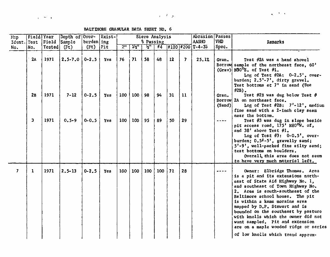
BALT3I4ORE GRANULAR DATA SHEET NO. 6
'1ap Field Year Depth of Over- exist- Sieve Analysis Abrasion Passes Ident. Test Field Sample burden ing %_Passing AASHO VHD Remarks
2A 1971 2.5-7.0 0-2.5 Yes 76 71 58 48 12 7 25.1 Gran. Test #2A was a hand shovel Borrow sample of the northeast face, 60' (Gray) N3O'E, of Test #1.
Log of Test #24: 0-2.5 1 , over. burden; 2.5 1 -7 1 , dirty gravel. Test bottoms at 7' in sand (See #2B).
2B 1971 7-12 0-2.5 Yes 100 100 98 94 31 11 Gran. Test #2B was dug below Test # Borrow 2A on northeast face. (Sand) Log of Test #2B: l'-12', medii
fine sand with a 2-inch clay seam near the bottom.
3 1971 0.5-9 0-0.5 Yes 100 100 95 89 50 29 ---- Test #3 was dug in slope besidi pit access road, 175' N80 0W. of, and 38' above Test #1.
Log of Test #3: 0-0.5', over- burden; 051_5', gravelly sand; 5'-9', well-packed fine silty sand test bottoms on boulders.
Overall, this area does not seei to have very much material left.
7 1 1971 2.5-13 0-2.5 Yes 100 100 100 100 71 28 ---- Owner: Elbridge Thomas, Area is a pit and its extensions north- east of State Aid Highway No. 1, and southeast of Town Highway No. 2. Area is south-southeast of the Baltimore school house. The pit is within a kame moraine area mapped by D.P. Stewart and is bounded on the southeast by pasturi with knolls which the owner did no want sampled. Pit and extension are on a maple wooded ridge or ser:
of low knolls which trend approx-
Les
- I (
I. I
BALTIMORE GRANULAR DATA SHEET NO. 7
ap Field Year Depth of Over- Exist- Sieve Analysis Abrasion Passes Ident, Test Field Sample burden ing % Passing AASHO VHD Remarks
imately northeasterly. Test #1 was dug on east face
of pit. Stratified bedding suggesi aeolian deposition or a Bmall delti
Log of Test #1: 0-2.5 1 , over- burden; 2,5-13', fine silty sand with some silt- or silt- clay seanu
2 1971 3-10 0-3 Yes 100 100 97 94 19 6 Sand Test #2 was dug on north face of pit. Log of Test #2: 0-1 1 ,
sod; 1 1 -3', stony overburden; 3 1 -
5 1 , pebbly sand; 5 1 -10', medium to fine sand; material gets finer with depth.
3 1971 0.5-7.5 0-0.5 Yes 100 84 81 73 3 2 Gran. Test #3 was dug in floor near Borrow center of pit, 60' west of Test (Gray) #1. Beds showed typical ice-contac
slumping. Log of Test 0: 0-0.5', over-
burden; 0.5'-7.5 1 , coarse sand wit pebbly sand. There are a few small cobbles. The material caves easil3 and looks good.
4 1971 1-7 0-1 Yes 100 100 100 99 22 5 Sand Test #4 was a hand shovel sam- ple of small bank 100' S55 0 Y. of pit.
Log of Test #4: 0-1', over- burden; 1_7, medium to fine sand with some pebbles.
8 1 1971 1-14 0-1 Yes 95 91 68 50 7 4 20.47. Gravel Owner: Miss Florence Dean. Area is a slightly sloping hillsidE with small pit and some knolls west northwest of the west end of Town Highway No. 6. Area is mapped as being just outside of D.P. Stewart'
kame moraine zone, and is just dowr
• -4
BALTIMORE GRANULAR DATA SHEET NO. B
Map Idont. No.
Field Test No,
Year Field Tested
Depth of Sample (Ft)
Over- burden (Ft)
Exist- ing Pit
Sieve Analysis %_Passing'
Abrasion AASHO T-4-35
Passes VHD Spec.
Remarks 2" 1?T ½" #4 #100 #200
slope from the lower part of the talus slope of Hawk's Mountain. The water table is close to the surface as evidenced by several brooks running through the propert and the presence of soggy spots in the field. The only possible extension of the small pit would be to the west-northwest. Town Highway No. 6 would need grading, and a small brook crossing would need a culvert or bridge to allow exploitation of the area.
Test #1 was a hand shovel sample on the southeast face of the tiny pit in a small kame.
Log of Test #1: 0-1', over- burden; 1 1 -12 1 , sandy fine gravel;
Test #2 was dug atop knoll, 25' west of Test #1. Most of the stones were sub-angular and in the 2" to 3" range.
Log of Test #2: 0-0.5', over- burden; 0.5-7.5 1 , gravel; 7.5 1 -9; sand (not sampled).
3 1971 1-8 0-1 No 100 100 92 89 32 7 Gran. Test #3 was dug atop a higher Borro% knoll, 100' west of, and 15' above (Sand) Test #2.
Log of Test #3: 0-1 1 , over- burden; 1-8', sand with some stone 8 1 _9 1 , boulders. Some fine gravel beds sloping from east to west were observed as a cap v61yirg fro one-foot to four-feet in thickness at the top of the. test.
a 1 , j
BALTIMORE GRANULAR DATA SHEET N0,9
Map Field Year Depth of Over- Exist- Sieve Analysis Abrasion Passes Ident. Test Field
ITested Sample burden ing Passing AASHO VHD Remarks
Owner was unable to give exact location of water supply.
9 1 1971 0.5-10 0-0.5 Yes 100 95 93 87 50 32 ---- Owner: Clifton Loomis. Area has tiny, overgrown diggings and a possible extension in woods east of brook and State Aid Highway No. 1, north of the Chester Town Line. Access to area is via field road which goes northeast from Chester Town Highway No. 22. Area is in pine woods north of hay fields.
Log of Test #1: O.5'-3 1 ,
pebbly sand; 3 1 -7 1 , sii.ty Band; 7 1 -8 1 , boulders; 8'-10', Silty sand. No boulders were included in test sample,
2 1971 0.5-10 0-0.5 No 100 90 82 76 16 8 Sand Test #2 was dug in a clearing on the slope of a knoll, 150' S70 0I of Test #1.
Log of Test #2: 0-0.5 1 , over- burden; 0.5 1 -2 1 , sand; 2 1 -4', gra-
- ______ velly sand; 4 1 -10 1 . rnud.
10 1 1971 0.5-15 0-0.5 Yes 100 100 100 98 15 4 Sand Owner: Clifton Loomis. Area is large sloping granular ridge which drops off to the east from State Aid Highway No. 1. There is a small pit near the road. The feature is within a mapped kame moraine of D.P. Stewart's survey.
Test #1 was a hand shovel samp] of the shallow northwest face of p1
Log of Test #1: 0-0.5', over- burden; 0.5 1 -15 1 , clean sand with
t.
S S
BALTIMORE GRANULAR DATA SHEET NO, 10
Iap Field Year Depth of Over- Exist- Sieve Analysis Abrasion Passes ident. Test Field Sample burden ing % Passing - AASHO VHD Remarks
some pebbly sand layers. Test bottoms at floor level in sand,
2 1971 0.5-11 0-0.5 Yes 100 100 100 100 51 14 Gran Test #2 was dug in floor near Borrm access road, 25', southeast of (Sand) Test #1.
Log of Test #2: 0-0.5 1 , over- burden; 0.5'-5 1 , sand with pebbles 5 1 -11', sand.
3 1971 1-10 0-1 No 100 100 100 100 94 75 --- Test #3 was dug on slope near access road, 245' east of Test #2.
Log of Test #3: 0-1', overbur den; 1-10', sandy silt.
4 1971 2-10 0-2 No 100 100 90 79 6 3 Sand Test #4 was dug on a low knoll 300' downhill and southeast of Test #3. Beds dip southeast and show ice-contact slumping. There is a gravelly cap overlying sand.