U.S. Fish and Wildlife Service U.S. Department of the Interior National Wildlife Refuge System Survey Protocol Framework for Monitoring Wilderness Character on National Wildlife Refuges Version 1.0 February 2019 Peter Dratch Nathan Phipps Cindy Hoang Marissa Edwards PETER DRATCH NATHAN PHIPPS CINDY HOANG MARISSA EDWARDS
Transcript
U.S. Fish and Wildlife Service U.S. Department of the Interior National Wildlife Refuge System
Survey Protocol Framework for Monitoring
Wilderness Character on National Wildlife Refuges
Version 1.0 February 2019
Peter Dratch
Nathan Phipps
Cindy Hoang
Marissa Edwards
PETER DRATCH
NATHAN PHIPPS
CINDY HOANG
MARISSA EDWARDS
ii
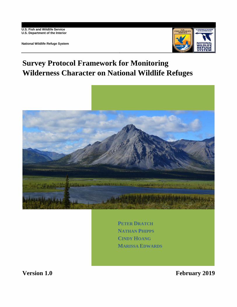
ON THE COVER
Description of image/photo used on front cover: The photo taken in 2013 is near the site where Olaus and Mardy Murie camped
and photographed in 1956. Photograph by: Franklin Dekker
iii
NWRS Survey Protocol Signature Page
1 Version is a decimal number with the number left of decimal place indicating the number of times this protocol has
been approved (e.g., first approved version is 1.0.; prior to first approval all versions are 0.x; after first approval, all
minor changes are indicated as version 1. x until the second approval and signature, which establishes version 2.0,
and so on). Only two signatures are required: one from the submitter (lead author)2 one from the approving official,
which is dictated by the scope of the protocol3,4,5. 2 Signature of station or I&M representative designated lead in development of a site-specific survey protocol. 3 Signature signifies approval of a site-specific survey protocol. 4 Signature by Regional I&M Coordinator signifies approval of a protocol framework to be used at multiple stations
within a Region. 5 Signature by National I&M Coordinator signifies approval of a protocol used at multiple stations from two or more
Regions.
iv
Survey Protocol Summary
This protocol provides the framework for assessing the character of wilderness areas that occur
within the National Wildlife Refuge System (Refuge System). The framework is intended to help
U.S Fish and Wildlife Service (FWS) employees carry out routine wilderness character
monitoring (WCM) on their refuges. The measures of wilderness character have been determined
by refuge staff and the data are often obtained routinely as part of refuge operations, as for
example, the number of permits issued, or the miles of trail maintained. The purpose of this
monitoring is to provide people with a tool to assess how attributes of wilderness character are
changing over long time periods, and to improve wilderness management in compliance with the
mandates of the 1964 Wilderness Act (Public Law 88-577). We describe how an overall trend in
wilderness character is determined for each wilderness area using a series of site-specific
measures which address nationally consistent indicators, monitoring questions and qualities. This
protocol framework is based on Keeping It Wild 2: An Updated Interagency Strategy to Monitor
Trends in Wilderness Character across the National Wilderness Preservation System (Landres et
al, 2015). This protocol framework provides a foundation and guidance for consistent
development of site-specific survey protocols with detailed instructions for wilderness character
monitoring throughout the Refuge System. The content and structure of the protocols described
follow the standards and methods set forth in the U.S. Fish and Wildlife Service guidance, How
to Develop Survey Protocols: a Handbook (Version 1.0). Each of the eight elements outlined in
the handbook is addressed, and include the protocol introduction, sampling design, field methods
and data processing, data management and analysis, reporting, personnel requirements and
training, operational requirements, and references. A series of standard operating procedures
provide additional details on recommended methods and technical aspects for carrying out the
protocol. It also describes the national wilderness character monitoring database that serves as a
repository for all four government agencies responsible for managing wilderness character
monitoring data. Each of the eight regions of the U.S. Fish and Wildlife Service has designated
wilderness areas, and all of these areas have selected measures for wilderness character
monitoring. Implementing this protocol helps ensure consistency for this monitoring across the
Refuge System and the National Wilderness Preservation System. This protocol is 508c
compliant to assist its use by those who are visually impaired.
Suggested citation:
Dratch P, Phipps N, Hoang C, Edwards M. 2018. Survey protocol framework for monitoring
wilderness character on national wildlife refuges. USFWS NWRS Natural Resources Program
Center, Fort Collins, CO.
This protocol is available from ServCat [https://ecos.fws.gov/ServCat/Reference/Profile/108922]
v
Acknowledgments
We acknowledge those who have worked diligently to discuss and develop the measures that
have helped to form this protocol framework: in particular, Nancy Roeper, NWRS National
Wilderness Coordinator, and Peter Landres of the Forest Service and the Aldo Leopold
Wilderness Research Institute, as well as all of the other authors of Keeping It Wild 2. This
protocol framework began with protocols for individual monitoring measures worked out with
Wilderness Fellows and refuge staff between 2011 and 2015. We want to acknowledge all of the
FWS Fellows and do so by year below, but a few have had a specific role in this framework and
deserve special mention: Monica Patel, Max Mutter and Elizabeth Mejicano. This protocol
would not have been completed without the support at the Natural Resource Program Center,
especially Mark Chase, Jana Newman and Richard Easterbrook.
FWS National Wildlife Refuge System Wilderness Fellows
2011: Ben Edwards, Ben Weiss, Corey Anco, Erin Clark, Kelly Lockman, Matt Strausser,
Monica Patel, Molly McCarter and Rachael Carnes
2012: Kelly Pippins, Mark Swenson, Steve Zweber, Taryn Sudol and Thomas Jablonowski
2013: Anna Peterson, Franklin Dekker, Nyssa Landres, Paul Haverkamp and Sarah Shpak
2014: Alicia Vasto, Benjamin Katz, Casey Alexander, Christian Vlautin, Elizabeth Mejicano,
Max Mutter and Morgan Gantz
2016: Allison McCluskey, Lauren Slater, Marissa Edwards and Nathan Phipps
2017: Alicia Thomas and Keith Adams
This protocol underwent extensive internal and external review that was adeptly organized by
Mary Grant. We appreciate the formal reviews contributed by Mary Emerick, Beth Hahn,
Adrienne Lindholm, James Sippel, Roger Kaye, Kevin O’Hara, Khem So, and Tim Fotinos.
vi
Contents
NWRS Survey Protocol Signature Page ........................................................................................ iii
Survey Protocol Summary ............................................................................................................. iv
Acknowledgments........................................................................................................................... v
Contents ......................................................................................................................................... vi
Introduction ......................................................................................................... 1 Background .................................................................................................................. 1 Why do we need an interagency protocol for wilderness character monitoring? ........ 1 Who will use this protocol framework? ....................................................................... 2
What is the terminology associated with wilderness character? ................................. 2
What are wilderness character monitoring measures? ................................................. 3
Sample selection and size .......................................................................................... 13 Survey timing ............................................................................................................. 13
Sources of error .......................................................................................................... 14
Field Methods and Processing of Collected Material ....................................... 15 Organizational framework ......................................................................................... 15
Matching a measure with the appropriate quality of wilderness character ............... 15 Processing of collected materials............................................................................... 16 End-of-season procedures .......................................................................................... 16
Data Management and Analysis ....................................................................... 17 Data entry, verification and storage ........................................................................... 17 Data security and archiving ....................................................................................... 17 Metadata .................................................................................................................... 17
Assessing wilderness character trends ....................................................................... 18
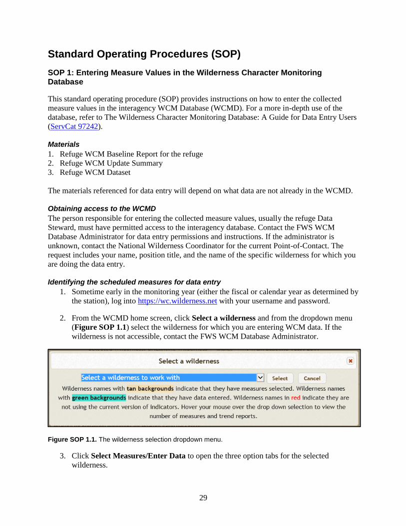
Standard Operating Procedures (SOP).......................................................................................... 29
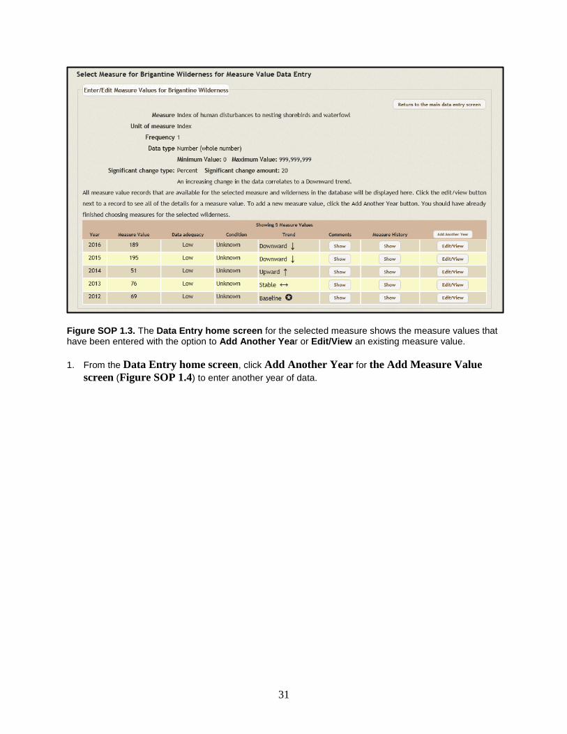
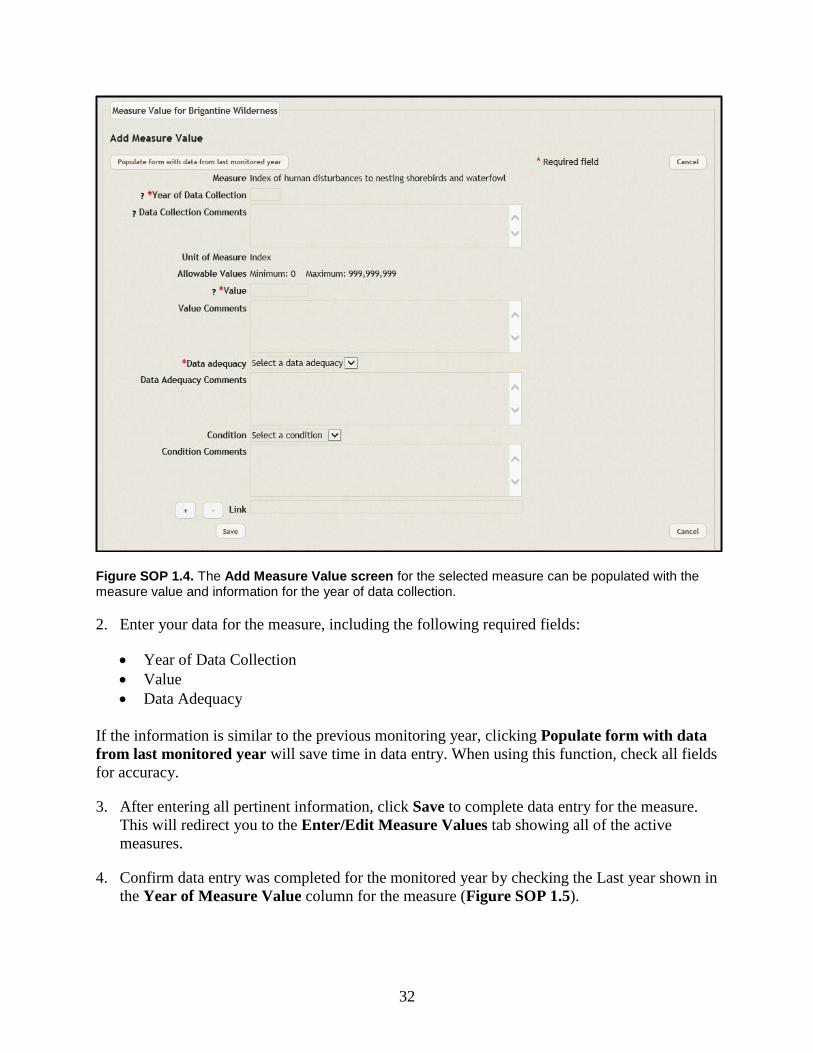
SOP 1: Entering Measure Values in the Wilderness Character Monitoring Database ....... 29 Materials .................................................................................................................... 29 Obtaining access to the WCMD ................................................................................ 29
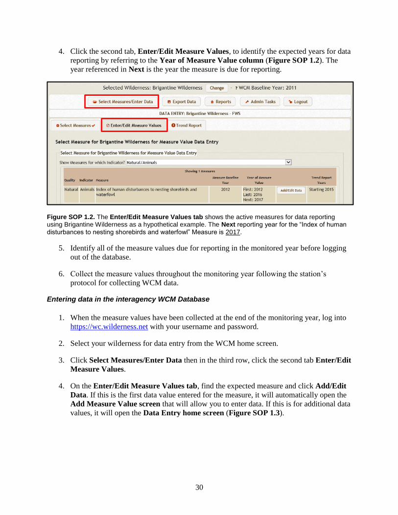
Identifying the scheduled measures for data entry .................................................... 29 Entering data in the interagency WCM Database ...................................................... 30
SOP 2: Entering Wilderness Character Monitoring Data in ServCat ................................. 34
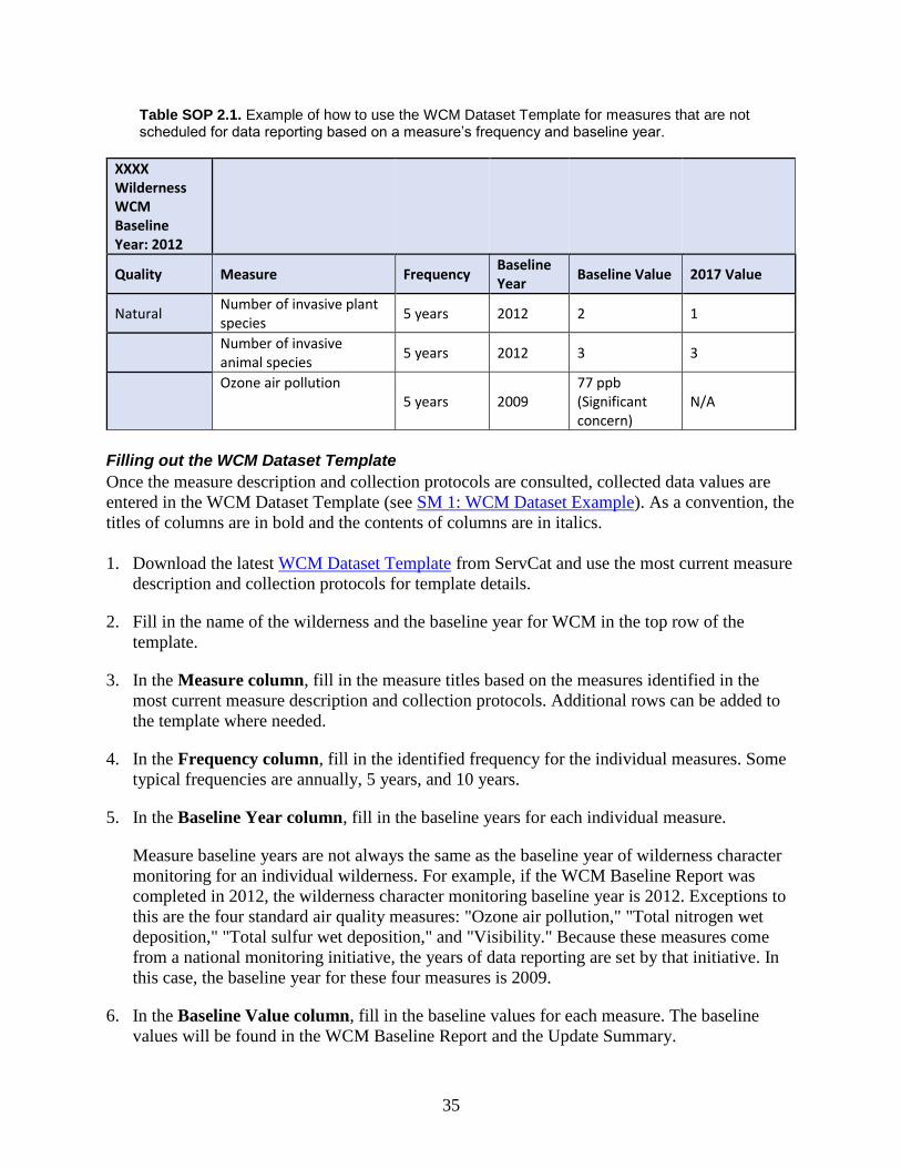
Gathering the WCM data values ................................................................................ 34 Filling out the WCM Dataset Template ..................................................................... 35 Uploading the Dataset in ServCat .............................................................................. 36
Entering Data in the interagency WCM Database ..................................................... 37 References .................................................................................................................. 37
SOP 3: Development of Wilderness Character Monitoring Update Summaries ................ 38
Following up with the refuge ..................................................................................... 41 Writing and editing the WCM Update Summary ...................................................... 42 Finalizing the WCM Update Summary ..................................................................... 43
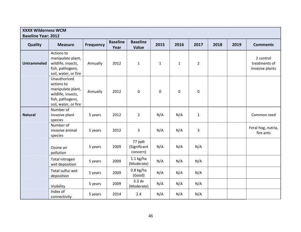
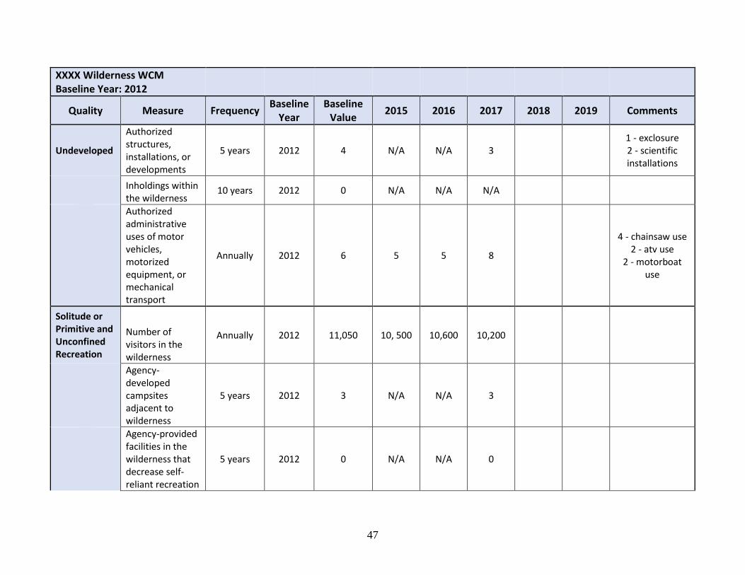
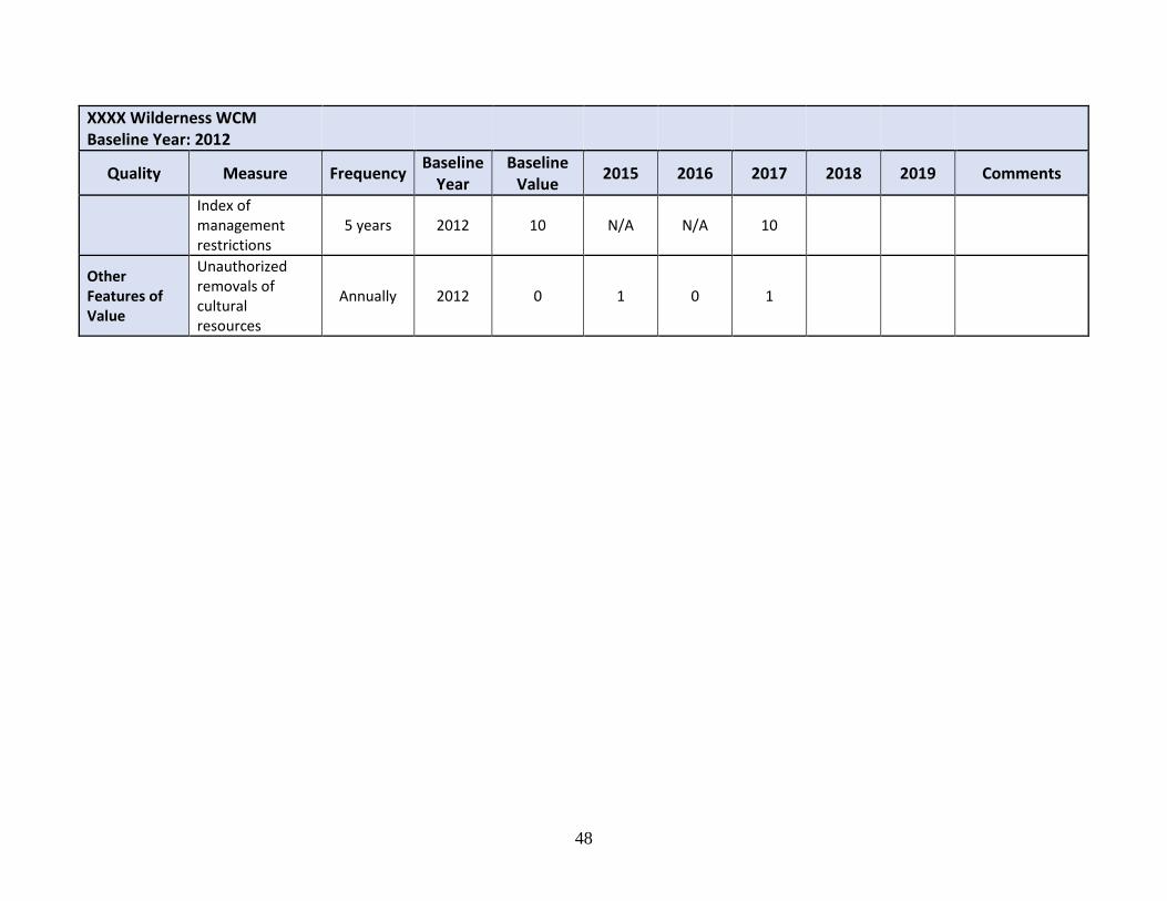
SM 1: WCM Dataset Example ............................................................................................ 45
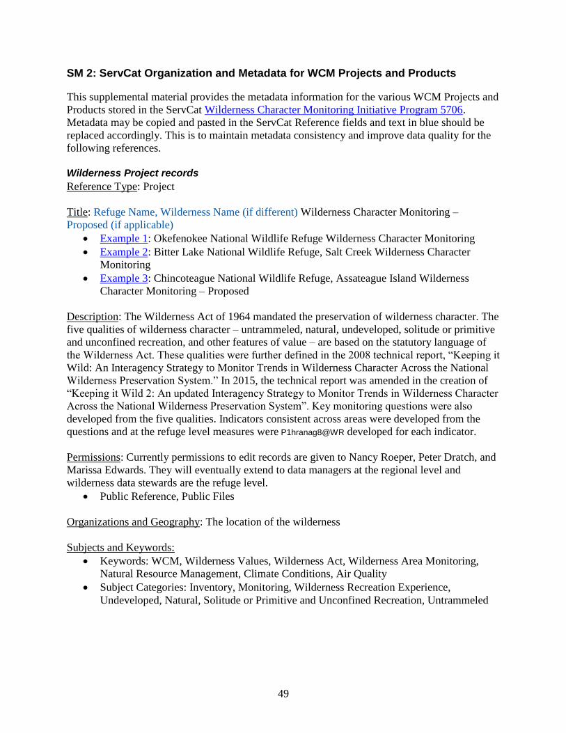
SM 2: ServCat Organization and Metadata for WCM Projects and Products .................... 49
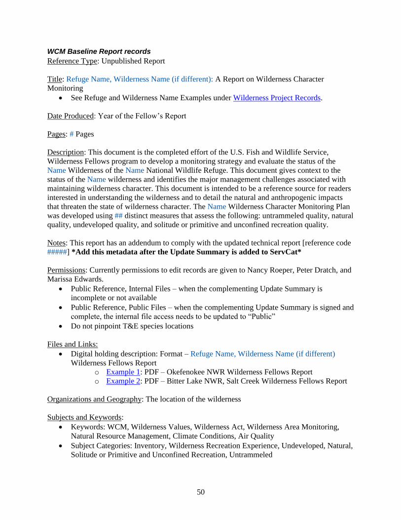
Wilderness Project records ........................................................................................ 49 WCM Baseline Report records .................................................................................. 50
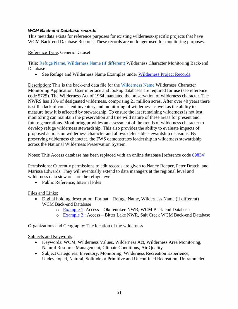
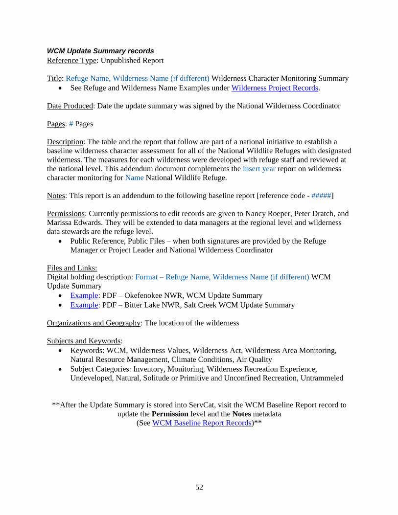
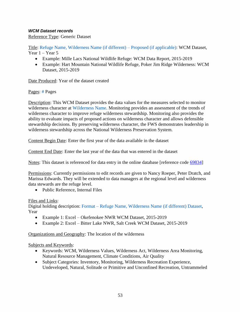
WCM Back-end Database records ............................................................................. 51 WCM Update Summary records ............................................................................... 52 WCM Dataset records ................................................................................................ 53
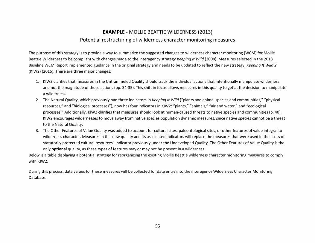
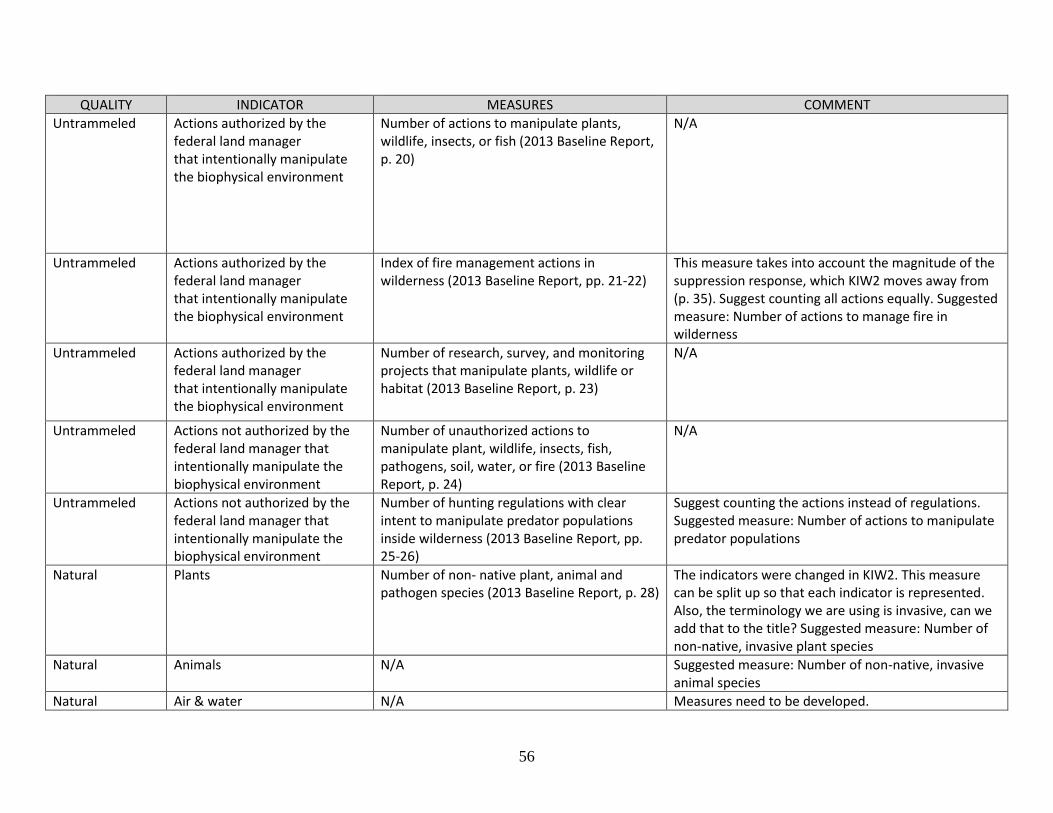
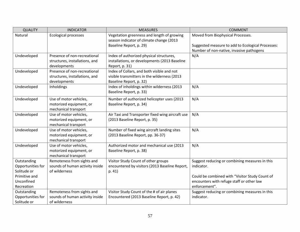
SM 3: Supporting Documents ............................................................................................. 54
1
Narrative
Introduction
Background
Section 2(a) of the Wilderness Act’s Statement of Policy states that wilderness areas “shall be
administered for the use and enjoyment of the American people in such manner as will leave
them unimpaired for future use and enjoyment as wilderness, and so as to provide for the
protection of these areas, the preservation of their wilderness character” (Public Law 88-577;
Wilderness Act 1964). In other words, in order to assure the protection and future use of these
areas as wilderness, their wilderness character must be preserved.
This affirmative legal mandate was developed into policies by the four federal agencies
managing wilderness areas. For the U.S. Fish and Wildlife Service (FWS), the Wilderness
Stewardship Policy (610 FW 1-5, 2008) provides an overview and foundation for implementing
the Wilderness Act in the National Wildlife Refuge System. Among other provisions, the policy
states that the FWS will administer wilderness consistent with the Nondegradation Principle,
which specifies that "at the time of wilderness designation, the conditions prevailing in an area
establish a benchmark of that area’s wilderness character and values. We will not allow the
wilderness character and values of the wilderness to be degraded below that benchmark.”
Decades after the Wilderness Act became law, and after Congress added many areas as
designated wilderness, the federal agencies realized that they could not confirm that they were
preserving wilderness character throughout the National Wilderness Preservation System
(NWPS). To uphold the statutory mandates of the Wilderness Act, agencies needed to agree on
the meaning of wilderness character, and determine how its preservation could be measured.
Under the leadership of the Aldo Leopold Wilderness Research Institute, representatives of the
agencies produced Keeping It Wild: An Interagency Strategy for Monitoring Wilderness
Character across the National Wilderness Preservation System (Landres et al. 2008). The
authors described wilderness character through the primary tangible qualities that it encompassed
directly from the language in the law: Untrammeled, Natural, Undeveloped, Solitude or
Primitive and Unconfined Recreation, and Other Features of Value.
The 2014 FWS Inventory and Monitoring Policy requires that refuges monitor wilderness
character, which is defined as the “the combination of biophysical, experiential, and symbolic
qualities that distinguishes wilderness from all other lands” (701 FW 2, 2014).
Why do we need an interagency protocol for wilderness character monitoring?
All wildernesses – independent of their managing agency – are guided by the same enabling
legislation that lays out their common objectives. Managing them all in a similar manner ensures
that the Wilderness designation carries the promise of a certain standard of quality.
The first nationally consistent interagency strategy for the assessment of wilderness character
preservation was set forth through Keeping It Wild: An Interagency Strategy for Monitoring
Wilderness Character across the National Wilderness Preservation System (Landres et al. 2008).
2
As agencies implemented the new strategy in their planning and management, adjustments were
made to better fit the particular objectives, capabilities and restrictions particular to each agency.
While some of these agency-specific changes were improvements over the original monitoring
strategy described in Keeping It Wild, they also detracted from the central goal of maintaining
consistency across all wildernesses. In response, Keeping It Wild 2 was published in 2015 to
address and remedy shortcomings in the original strategy. That publication, Keeping It Wild 2:
An Updated Interagency Strategy to Monitor Trends in Wilderness Character across the
National Wilderness Preservation System (Landres et al. 2015) provides the definitive reference
for this framework. It is generally cited as Keeping It Wild 2 rather than by author and date.
Who will use this protocol framework?
This protocol framework will be used by National Wildlife Refuge System staff, volunteers and
others for wilderness character monitoring on refuges throughout the United States. The basic
survey protocol is applicable to all refuges with wilderness areas, either designated or proposed,
and is intended to help inform and aid the development of management actions for preserving
wilderness character at the local and regional levels.
This standardized protocol framework will explain the underpinning of WCM plans, promote
management continuity, and help ensure that degradation of wilderness character, no matter how
gradual, does not go undetected. The data gathered from wilderness character monitoring will be
valuable in future analyses that will assess regional or national trends in wilderness character.
When it comes time to write site specific protocols for wilderness areas on refuges, this
framework will inform that process and greatly streamline the writing. In combination with the
Baseline Report on and the Update Summary, this framework should expedite work by refuge
staff on the site-specific protocol.
What is the terminology associated with wilderness character?
Since the initial description of wilderness character in 2005, there has been some confusion
among agency staff, non-government organizations, and the public regarding the language used
in discussions of wilderness character. To remedy this confusion, Keeping It Wild 2 defined key
terms, clarified how certain terms are used, and explained why some terms are no longer used.
Terms used in the description and discussion of wilderness character in this protocol:
Wilderness character: A holistic concept comprised of qualities that distinguish wilderness from
all other lands, “based on the interaction of (1) biophysical environments primarily free from
modern human manipulation and impact, (2) personal experiences in natural environments
relatively free from the encumbrances and signs of modern society, and (3) symbolic meanings
of humility, restraint, and interdependence that inspire human connection with nature.”
Wilderness qualities: Any of the five qualities of wilderness character derived from the statutory
definition of wilderness in the Wilderness Act and further described in Keeping It Wild 2:
Untrammeled, Natural, Undeveloped, Solitude or Primitive and Unconfined Recreation, and
Other Features of Value.
3
Wilderness resources: Any of the particular resources (natural or cultural) inside a wilderness.
Wilderness values: Any of the meanings, benefits, or values, people or society derive from
wilderness.
Wilderness character monitoring: The process of assessing the specific and overall trends in
wilderness character using the interagency strategy described in Keeping It Wild 2.
Terms not used in this protocol:
Wilderness characters: This term causes confusion because it has alternately been used to refer
to either “wilderness character” or “wilderness qualities.”
Wilderness characteristics: This term also causes confusion, as it may be interpreted to denote
wilderness qualities or some other aspect of wilderness. This term was originally used in BLM
and FS laws and policies, but should be avoided within the FWS.
Wild character: It has been used as shorthand for wilderness character, but wild has many
interpretations that are broader and can lead to an unclear application of wilderness attributes.
Characters: As shorthand for wilderness characters or wilderness qualities, this phrase is vague
and can lead to confusion.
Commonly Used Acronyms:
KIW: Keeping It Wild (2008)
KIW2: Keeping It Wild 2 (2015)
FWS: United States Fish and Wildlife Service
NWRS: National Wildlife Refuge System
WCM: Wilderness character monitoring
WCMD: The interagency Wilderness Character Monitoring Database
What are wilderness character monitoring measures?
Measures are the specific elements under each indicator for which data are collected to assess
trend in that indicator. They are chosen by refuge personnel, usually with the advice of
Wilderness Fellows who spend time in residence at the refuge to help develop the measures.
They are first proposed in the refuge wilderness Baseline Report and confirmed in the refuge
Update Summary. In general, measures are human-caused threats to the indicator which degrade
wilderness character.
4
Objectives
A sampling design requires clear objectives. For this survey protocol framework, the objective is
to consistently assess how the attributes of wilderness character are changing over long time
periods in order to inform and improve wilderness management on wildlife refuges.
To address the need for interagency consistency, a standardized strategy (KIW and KIW2) was
developed to monitor wilderness character using five qualities drawn directly from the enabling
legislation: Untrammeled, Natural, Undeveloped, Solitude or Primitive and Unconfined
Recreation, and Other Features of Value. Each quality is assessed through a descending
hierarchy of component parts – monitoring questions, indicators, and measures – with each of
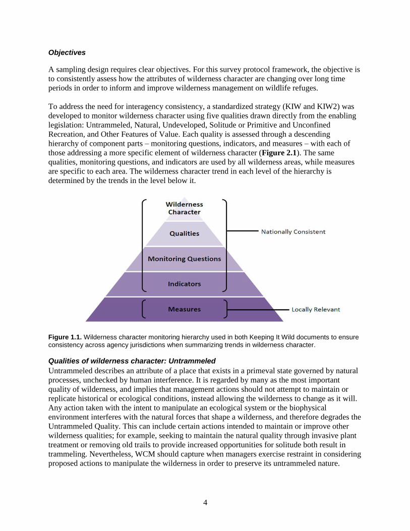
those addressing a more specific element of wilderness character (Figure 2.1). The same
qualities, monitoring questions, and indicators are used by all wilderness areas, while measures
are specific to each area. The wilderness character trend in each level of the hierarchy is
determined by the trends in the level below it.
Figure 1.1. Wilderness character monitoring hierarchy used in both Keeping It Wild documents to ensure consistency across agency jurisdictions when summarizing trends in wilderness character.
Qualities of wilderness character: Untrammeled
Untrammeled describes an attribute of a place that exists in a primeval state governed by natural
processes, unchecked by human interference. It is regarded by many as the most important
quality of wilderness, and implies that management actions should not attempt to maintain or
replicate historical or ecological conditions, instead allowing the wilderness to change as it will.
Any action taken with the intent to manipulate an ecological system or the biophysical
environment interferes with the natural forces that shape a wilderness, and therefore degrades the
Untrammeled Quality. This can include certain actions intended to maintain or improve other
wilderness qualities; for example, seeking to maintain the natural quality through invasive plant
treatment or removing old trails to provide increased opportunities for solitude both result in
trammeling. Nevertheless, WCM should capture when managers exercise restraint in considering
proposed actions to manipulate the wilderness in order to preserve its untrammeled nature.
5
Managerial restraint any time a trammeling action is evaluated will result in an upward trend for
this measure.
The Untrammeled Quality is addressed by one monitoring question: what are the trends in
actions that intentionally control or manipulate “the earth and its community of life” inside
wilderness? Keeping It Wild 2 defines a trammeling as “an action that purposefully alters,
hinders, restricts, controls, or manipulates the earth and its community of life, including the type,
quantity, or distribution of plants, animals, physical resources (such as air, water, or soil), or
biophysical processes (such as fire) inside a designated wilderness.” Small actions such as hand
pulling a few weeds can be considered and discounted as not of sufficiently large scale, but all
proposed actions should be evaluated. Intention is a key component for measures of the
Untrammeled Quality. Accidental events that alter ecological elements or biophysical processes
as an unanticipated consequence of their intended effect, do not count as trammeling actions.
Appendix 6 in KIW2 has a detailed discussion and many examples of what would or would not
typically be considered trammeling actions.
There are two indicators for this monitoring question: Actions authorized by the federal land
manager that intentionally manipulate the biophysical environment, and Actions not authorized
by the federal land manager that intentionally manipulate the biophysical environment.
Indicator 1: Authorized actions that intentionally manipulate the biophysical environment
In Keeping It Wild 2, this indicator is specified to encompass all significant trammeling actions
authorized by the managing agency of the wilderness, including those allowed under Section
4(d)(1) of the Wilderness Act. It states “measures may be taken as may be necessary in the
control of fire, insects and disease, subject to such conditions as the Secretary deems desirable.”
This indicator includes trammeling actions performed by other agencies or private citizens if
those actions are authorized by the FWS. Significance of a trammeling action, as with any
measure, is defined by a threshold, further elaborated in the “Assessing wilderness character
trends” section of Element 4. Examples of measures for this indicator include the decision to act
to suppress naturally occurring fires, actions to ignite controlled burns, and actions to remove
invasive species. An increase in authorized federal actions that intentionally manipulate the
biophysical environment results in a downward trend for this measure.
Indicator 2: Actions not authorized that intentionally manipulate the biophysical environment
Although most trammeling is the result of actions taken by the federal managing agency,
unauthorized actions to intentionally manipulate a wilderness often have a significant impact on
wilderness character. Measures of this indicator should track any significant trammeling actions
not covered by the first indicator, including any actions by other government or private agencies
or citizens that have not received authorization from the FWS. Examples of possible
unauthorized trammeling include a person stocking wilderness lakes with fish, or a photography
group leaving food as a lure to assure animals were in a particular place. An increase in actions
not authorized by the federal land manager that nonetheless do manipulate the biophysical
environment results in a downward trend for this measure
6
Qualities of wilderness character: Natural
The Natural Quality addresses effects of modern civilization on wilderness areas. A central
concern in the 1964 Wilderness Act is the threat of “an increasing population, accompanied by
expanding settlement and growing mechanization” (Section 2(a)). This quality targets the
preservation of a wilderness’ ecological systems in a natural state, including all biological and
physical processes. While the Untrammeled Quality monitors actions taken within the wilderness
that intentionally manipulate the environment, the Natural Quality monitors the effects of modern
human civilization on the wilderness as an ecological system. Those impacts can be intentional
or unintentional, including sources outside the wilderness that have an effect on the wilderness.
There is one monitoring question for the Natural Quality: what are the trends in the natural
environment from human-caused change? Unlike in the Untrammeled Quality, management
intent is not relevant in measures of the Natural Quality. Effects on the biological or physical
wilderness environment caused by humans degrades this quality of wilderness character.
Measures under all four indicators of the Natural Quality should be relevant to known human-
caused threats, based on reliable and repeatable measurements, and should not be based on
historical conditions or the prevention of change from current conditions.
The four indicators for this monitoring question are Plants, Animals, Air and Water, and
Ecological Processes.
Indicator 1: Plants
One major effect of modern human civilization is the alteration of ecological systems.
Indigenous plant species and communities are foundational elements of a wilderness ecosystem.
Significant changes in plant community composition may result in cascading effects on the
larger biotic community and its physical environment. This indicator monitors the primary
threats to native plants, which are usually the introduction of invasive, non-indigenous plants in
the wilderness. Non-vascular plants (e.g. bryophytes and lichens) and fungi are included in this
indicator. Example measures for this indicator include the number, distribution and abundance of
invasive plant species. An increase of non-indigenous plant species results in a downward trend
in this measure.
Indicator 2: Animals
Indigenous animals are an essential part of a wilderness ecosystem, and are important in the
regulation of wildlife populations, species diversity, and community structure. This indicator
monitors the primary threats to indigenous animals: the addition of non-indigenous animal
species and human disturbances to indigenous species. Example measures for this indicator
include the number, distribution, or abundance of invasive animal species. An increase of animal
taxa that are not indigenous to the wilderness results in a downward trend in this measure.
Indicator 3: Air and Water
Clean air and water are obviously essential to multiple ecological functions, and may be altered
by outputs of human industry and development outside of a wilderness. This indicator monitors
the quantity of selected pollutants in close proximity to a wilderness, as well as measurable
physical effects of pollution on visibility and the diversity and abundance of pollution-sensitive
indigenous species. It also tracks the effects inside the wilderness of physical manipulations of
7
free-flowing water both inside and outside the wilderness area. Four standard measures of air
quality form one foundation of this indicator, while unique measures of water quality can be
selected that are specific to a wilderness. Air quality comprises four standard measures for this
indicator: ozone air pollution, total nitrogen wet deposition, total sulfur wet deposition, and
visibility. An example of a water quality measure would be altered flow rates. An increase in the
effect of pollution or water flow alteration results in a downward trend for this measure.
Indicator 4: Ecological Processes
This indicator tracks changes in any major ecological process that impact multiple components
of natural systems within a wilderness. Watershed condition, migration patterns, and stream bank
erosion are examples of such processes. Even slight changes in these interconnected processes
often result in wide-reaching consequences at multiple levels of the natural system. Because
ecological processes are constantly changing, many measures of this indicator register the
magnitude or intensity of factors that cause the processes. Examples of measures that may be
included in this indicator are average watershed condition class and connectivity index.
Measures of anthropogenic climate change, when adopted, also belong under this indicator. An
increase in connectivity results in an upward trend for this measure.
Qualities of wilderness character: Undeveloped
The Undeveloped Quality, cited in Section 2(c) of the Wilderness Act, is described as “an area of
undeveloped Federal land retaining its primeval character and influence, without permanent
improvements or human habitation,” and with “the imprint of man’s work substantially
unnoticeable.” Keeping It Wild 2 summarizes the Undeveloped Quality for this monitoring
strategy: “wilderness is essentially without permanent improvements or the sights and sounds of
modern human occupation.” The level of development and use of mechanized transport,
motorized equipment, and structures made by people prior to the establishment of the wilderness
are included in the baseline. An increase in development and mechanization results in a
downward trend in this quality.
There are two monitoring questions for this quality. The first question is: what are the trends in
non-recreational physical development? Permanent physical structures and modifications take
away from the wilderness experience because they are evidence of modern civilization and
human occupation. This monitoring question is concerned only with modern human occupation;
developments made by indigenous peoples are therefore excluded from this quality. Only
modern physical developments, or installations not primarily intended for a recreational purpose
are included in the Undeveloped Quality. Structures and modifications that provide for
recreational activities such as trails and camping facilities are included in the Solitude or
Primitive and Unconfined Recreation Quality.
The two indicators for this monitoring question are Presence of non-recreational structures,
installations, and developments, and Presence of inholdings.
Indicator 1: Presence of non-recreational structures, installations, and developments
There are many types of physical structures and modifications to a wilderness that may be
relevant to this indicator, including the following: dams, pipelines, road beds, mines, and
permanent communication, sanitation or research instrumentation facilities. There may also be
8
structures and modifications that remain from before wilderness designation that may be allowed
to continue functioning by legal provision. However, all permanent structures, installations and
developments are encompassed by this indicator, including those that are defunct or that predate
wilderness designation, as well as scientific installations and historic structures. Additionally,
large trash objects (e.g. vehicles, aircraft, operational equipment, mining debris, and trash
dumps) are included in this indicator, despite not encompassing some definitions of structures,
installations or developments. Examples of measures for this indicator include the number, size,
and type of developments within the wilderness area. Measures of the number of tagged animals
and the number of nest boxes would also fall within this indicator. While putting radio-collars or
ear-tags on animals would be trammeling actions, their continued presence is recorded under this
indicator. An increase in the presence of non-recreational structures, installations, and
developments results in a downward trend for this measure.
Indicator 2: Presence of inholdings
Although inholdings within refuge wilderness areas are not owned or managed by the FWS, they
represent a degradation to the Undeveloped Quality of the wilderness. Inholdings may be sold or
developed for a wide variety of purposes that may be out of line with the wilderness mission.
Therefore, the acquisition and assimilation of inholdings by the FWS is often a priority.
Examples of measures under this indicator are the acres or number of inholdings in wilderness.
An increase in the acreage or number of inholdings, or legal agreements with inholding owners
to limit development, results in a downward trend for this measure.
The second monitoring question for the Undeveloped Quality addresses mechanization. Under
the Wilderness Act, the managing agency of a wilderness may authorize a variety of mechanized
activities insofar as they are the minimum requirement necessary for the administration of the
area for the purpose of the Wilderness Act. Mechanized use may also be permitted in emergency
situations and in special cases where a wilderness law provides for specific mechanized
activities. In both cases, these uses are counted. The indicator for this monitoring question is Use
of motor vehicles, motorized equipment, or mechanical transport.
Indicator 3: Use of motor vehicles, motorized equipment, or mechanical transport
Keeping It Wild 2 specifies that this indicator tracks the use of motor vehicles, motorized
equipment, and mechanical transport, collectively called mechanized uses for “administrative,
emergency, and other non-emergency purposes such as access to mineral rights, state land, and
private land, and provision of other laws.” Examples of measures for this indicator include
administrative authorizations of mechanized uses, motorized equipment, or mechanical transport,
and the number of unauthorized mechanized uses per unit of effort or time. An increase in use of
mechanized equipment or motor vehicles results in a downward trend for this measure.
Qualities of wilderness character: Solitude or primitive and unconfined recreation
The purpose of wilderness designation is not only to preserve the integrity of the natural
environment as expressed in the previous three qualities, but also to serve the public as an area
for personal interaction with nature. According to section 2(c) of the Wilderness Act, one key
purpose of wilderness is to provide “outstanding opportunities for solitude or a primitive and
unconfined type of recreation.” Solitude encompasses a number of experiential benefits,
including privacy, inspiration, a sense of timelessness, and separation from civilization. Primitive
9
recreation predominantly refers to travel by non-motorized and non-mechanical means, with the
benefit of reinforcing one’s connection to our shared ancestral heritage. Unconfined recreation is
defined by a freedom from managerial guidance or restriction on recreational activities.
Holistically, this quality is monitored to ensure that wilderness visitors may experience the
physical and psychological benefits derived from self-reliance, personal challenge, and the
freedom of mind and body from the constraints of civilization. There is an inherent tension
between the Wilderness Act’s outdoors recreational objectives and the quality of preserving the
solitude or primitive and unconfined recreation. When more visitors are allowed into an area,
opportunities for solitude are reduced and increased managerial restrictions on recreation are
often required to preserve the wilderness in perpetuity. Properly considering the consequences of
potential managerial actions on visitor opportunities for solitude or primitive and unconfined
recreation is essential to ensure that this aspect of wilderness does not degrade over time.
There are two monitoring questions for this fourth quality. The first monitoring question is: what
are the trends in outstanding opportunities for solitude? Solitude is degraded by any aspects of
the wilderness setting that serve to remind visitors of human civilization. These characteristics
include increased visitation, the growth of nearby human populations, or areas of concentrated
visitor use within the wilderness.
The two indicators for this monitoring question are Remoteness from sights and sounds of
human activity inside the wilderness and Remoteness from sights and sounds of human activity
outside the wilderness.
Indicator 1: Remoteness from sights and sounds of human activity inside the wilderness
This indicator allows managers to track the conditions that are within the boundaries of the
wilderness unit, and therefore more subject to management control. To achieve a sense of
solitude, it is important to find remoteness from evidence of modern human civilization and
activity. Seeing or hearing the presence of many other people within the wilderness detracts from
this sense of solitude and therefore degrades this quality. Solitude can be found on established
travel routes when visitation is low, or by entering undeveloped areas where fewer visitors are
likely to travel. This indicator should track the number, density, and sensory or physical evidence
of visitation, which includes trash and debris that degrade most people’s sense of remoteness.
Examples of measures for this indicator are the number of visitor encounters on travel routes;
number of occupied campsites within sight and sound of one another; area of wilderness away
from access and travel routes or developments; index of user-created campsites; and miles of
user-created trails. Increases in the number for any of these measures results in a downward trend
for this measure.
Indicator 2: Remoteness from sights and sounds of human activity outside the wilderness
This indicator tracks human activity outside the wilderness boundary that is evident within the
wilderness. Despite being largely outside the managerial authority of the wilderness unit, such
activity may nonetheless degrade the sense of solitude found within the wilderness. Significant
signs of human activity outside the wilderness that may be measured for this indicator include
sights and sounds of automobiles and off-road vehicles on nearby travel routes; airplanes flying
over wilderness; development and use of inholdings; air and light pollution from nearby
developed areas; and urbanization. These sights and sounds are often measured from high ridges
10
and peaks within the wilderness. Examples of measures for this indicator are: area of wilderness
not affected by travel routes and developments outside the wilderness; night sky visibility; and
number of user-created facilities adjacent to the wilderness. Increases in the number of outside
developments and user-created facilities results in a downward trend for this measure.
The second monitoring question is: what are the trends in outstanding opportunities for primitive
and unconfined recreation? This monitoring question addresses the importance of providing
opportunities for non-motorized and non-mechanized travel, self-reliance and discovery, and
freedom from social pressures and constraints. Self-reliance through the development of
independent wilderness skills is an integral part of primitive recreation. Therefore, this quality is
degraded by the presence of facilities that make wilderness travel easier, such as high-standard
trails, bridges, and campsites. Unconfined recreation refers to recreational opportunities which
allow visitors a high degree of freedom over their own actions and decisions. Opportunities for
unconfined recreation are decreased by management restrictions on visitor travel and activity.
The two indicators for this monitoring question are Facilities that decrease self-reliant recreation
and Management restrictions on visitor behavior.
Indicator 3: Facilities that decrease self-reliant recreation
There are a variety of different structures, installations, and developments that may be
constructed to facilitate wilderness access and use, improve visitor safety, or protect wilderness
resources from cumulative visitor activity. Facilities constructed for these purposes are
considered recreational in the wilderness character monitoring strategy of Keeping It Wild 2.
Such facilities include, but are not limited to bridges, system trails and trail signs, toilets, aircraft
landing strips, hardened and designated campsites, sleeping platforms in swamp biomes, and
food storage lockers or bear poles in areas with bear activity. This indicator tracks all such
durable or relatively permanent facilities provided by the managing agency that affect primitive
recreation opportunities. It also extends to facilities or services without a physical presence but
which nonetheless diminish self-reliant recreation, such as cell-phone coverage. Example of
measures include miles of developed trails, number of trail signs, an index of authorized
recreational facilities and the area of cell-phone coverage. More facilities that decrease self-
reliant recreation results in a downward trend for this measure.
Indicator 4: Management restrictions on visitor behavior
This indicator tracks the number, type, or extent of management restrictions on visitor behavior.
In the context of wilderness character monitoring, such management restrictions refer to agency
regulations or policies that govern the behavior, travel, or equipment of wilderness visitors.
Examples of measures for this indicator include the number of restrictions on a backcountry
camping permit, and an index of visitor management restrictions based on area size, duration,
and intensity of the restriction. More management restrictions on visitor behavior results in a
downward trend for this measure.
Qualities of wilderness character: Other features of value
In Section 2(c), the Wilderness Act states that in addition to the four qualities previously
described, wilderness “may also contain ecological, geological, or other features of scientific,
educational, scenic, or historical value.” The Other Features of Value Quality encompasses
11
unique wilderness features that significantly contribute to the character of a particular wilderness
but do not readily fit under any of the other four qualities. Although such features may be
valuable for a number of different reasons, monitoring for this quality focuses on the physical
condition of these tangible features. Wilderness managers have some ability to directly protect or
improve the physical condition of a given feature, whereas intangible values of these features are
very difficult to quantify. Therefore, monitoring of this quality does not attempt to track the
scientific, educational, scenic, or historical values derived from these features. The determination
of which features belong to the Other Features of Value Quality is nuanced. Intangible resources
such as spiritual values, traditional practices, and traditional historic stories are aspects of this
quality, but are not included in monitoring. Instead, they may be addressed in the narrative
section of wilderness character monitoring reports. The document titled All Common Measures
has further guidance and discussion on which features are appropriate for wilderness character
monitoring.
Three important distinctions differentiate the Other Features of Value Quality from the other four
qualities:
1. Monitoring of this quality is not required. Unlike the other qualities that must be
monitored at every wilderness, Section 2(c) notes that other features of value may be
present, but are not required to be present. This quality should be used only when there
are features that are integral to the character of the wilderness.
2. This quality focuses on site-specific features, while the other four qualities apply to the
entire wilderness area. Keeping It Wild 2 notes, however, that some features of this
quality occupy a larger area, including cultural landscapes, geological and
paleontological formations.
3. Where this quality is included, it is also calculated in the overall trend in wilderness
character. Measures developed for any Other Features of Value will determine that this
quality carries the same weight as the others in determining the overall trend in
wilderness character. Careful consideration must be used to determine whether a feature
is integral to the wilderness character and whether the available data quality for the
measure is sufficient to justify its inclusion. Especially when few other features of value
are used as measures, they may disproportionately affect the overall trend in wilderness
character.
There is a single monitoring question for this quality: what are the trends in the unique features
that are tangible and integral to wilderness character? This question assesses the trend in site-
specific features that are unique and integral to the character of the wilderness. There are two
indicators for this monitoring question. If the Other Features of Value Quality is used, either one
or both of the indicators may be considered depending on the types of relevant integral features.
A decline in the physical condition of any feature chosen for this measure indicates a downward
trend in wilderness character for this quality.
Indicator 1: Deterioration or loss of integral cultural features
This indicator tracks the physical condition of cultural features that have been deemed integral to
the character of a particular wilderness, as well as authorized and unauthorized actions that
damage or disturb these features. In this monitoring strategy, the term cultural includes both
prehistoric and historic features. Example measures for this indicator include: condition index for
integral cultural features, and number of authorized or unauthorized actions that damage or
disturb integral cultural features. A decline in the condition or an increase in actions that damage
or disturb selected cultural features results in a downward trend in this measure.
Indicator 2: Deterioration or loss of other integral site-specific features
This is a catch-all indicator that tracks the physical condition of other site-specific features of
value that have been deemed integral to wilderness character. Most wildernesses will not have
other unique, integral, site-specific features outside of the first indicator. However, this indicator
provides flexibility to include any other locally relevant information that captures iconic
geological, paleontological, and other features of value. Example measures for this indicator
include: condition index of integral geological, paleontological, or other features; and number of
authorized and unauthorized actions that damage or disturb integral geological, paleontological,
or other features. A decline in the condition or an increase in actions that damage or disturb other
integral site-specific features results in a downward trend in this measure.
13
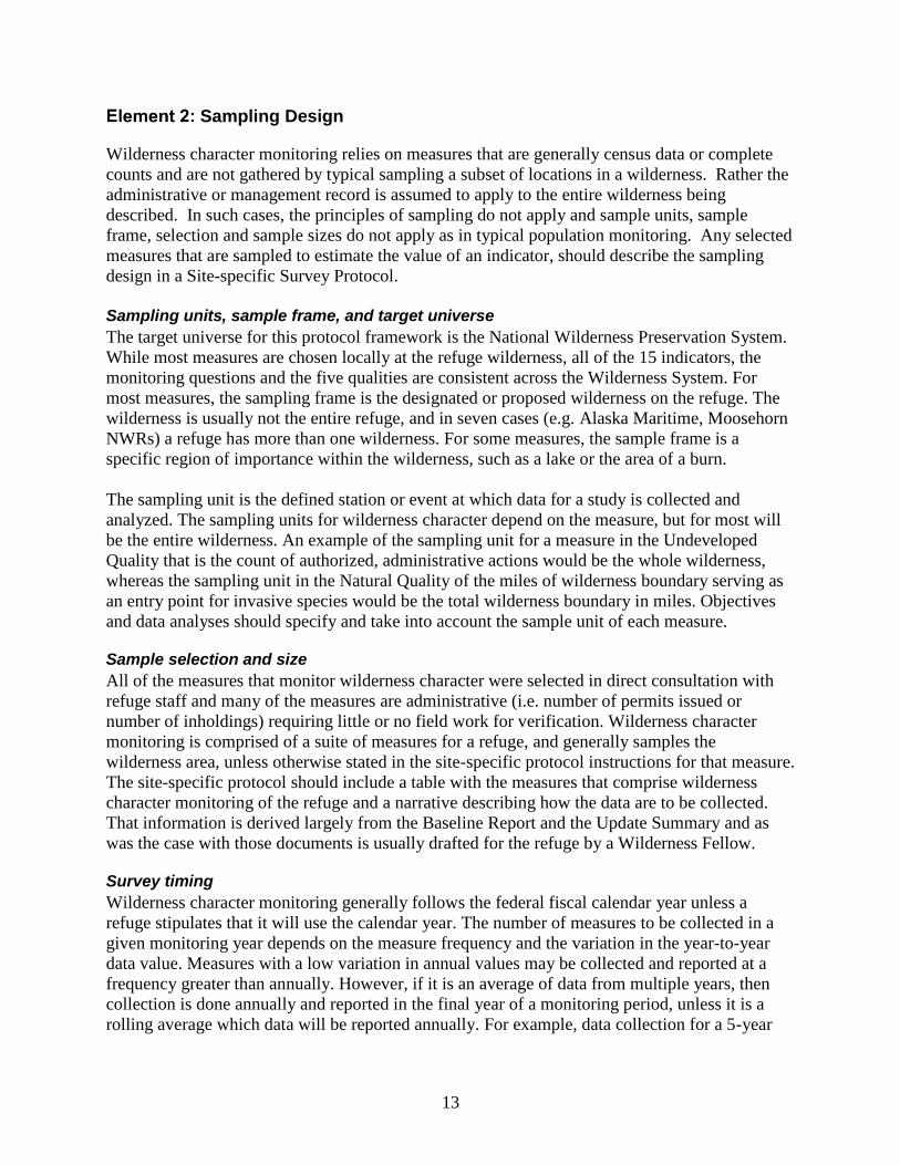
Sampling Design
Wilderness character monitoring relies on measures that are generally census data or complete
counts and are not gathered by typical sampling a subset of locations in a wilderness. Rather the
administrative or management record is assumed to apply to the entire wilderness being
described. In such cases, the principles of sampling do not apply and sample units, sample
frame, selection and sample sizes do not apply as in typical population monitoring. Any selected
measures that are sampled to estimate the value of an indicator, should describe the sampling
design in a Site-specific Survey Protocol.
Sampling units, sample frame, and target universe
The target universe for this protocol framework is the National Wilderness Preservation System.
While most measures are chosen locally at the refuge wilderness, all of the 15 indicators, the
monitoring questions and the five qualities are consistent across the Wilderness System. For
most measures, the sampling frame is the designated or proposed wilderness on the refuge. The
wilderness is usually not the entire refuge, and in seven cases (e.g. Alaska Maritime, Moosehorn
NWRs) a refuge has more than one wilderness. For some measures, the sample frame is a
specific region of importance within the wilderness, such as a lake or the area of a burn.
The sampling unit is the defined station or event at which data for a study is collected and
analyzed. The sampling units for wilderness character depend on the measure, but for most will
be the entire wilderness. An example of the sampling unit for a measure in the Undeveloped
Quality that is the count of authorized, administrative actions would be the whole wilderness,
whereas the sampling unit in the Natural Quality of the miles of wilderness boundary serving as
an entry point for invasive species would be the total wilderness boundary in miles. Objectives
and data analyses should specify and take into account the sample unit of each measure. Sample selection and size
All of the measures that monitor wilderness character were selected in direct consultation with
refuge staff and many of the measures are administrative (i.e. number of permits issued or
number of inholdings) requiring little or no field work for verification. Wilderness character
monitoring is comprised of a suite of measures for a refuge, and generally samples the
wilderness area, unless otherwise stated in the site-specific protocol instructions for that measure.
The site-specific protocol should include a table with the measures that comprise wilderness
character monitoring of the refuge and a narrative describing how the data are to be collected.
That information is derived largely from the Baseline Report and the Update Summary and as
was the case with those documents is usually drafted for the refuge by a Wilderness Fellow. Survey timing
Wilderness character monitoring generally follows the federal fiscal calendar year unless a
refuge stipulates that it will use the calendar year. The number of measures to be collected in a
given monitoring year depends on the measure frequency and the variation in the year-to-year
data value. Measures with a low variation in annual values may be collected and reported at a
frequency greater than annually. However, if it is an average of data from multiple years, then
collection is done annually and reported in the final year of a monitoring period, unless it is a
rolling average which data will be reported annually. For example, data collection for a 5-year
14
average is reported in the fifth year of data collection. The frequency of a measure is determined
in the measure selection process between the refuge staff and the Wilderness Fellow.
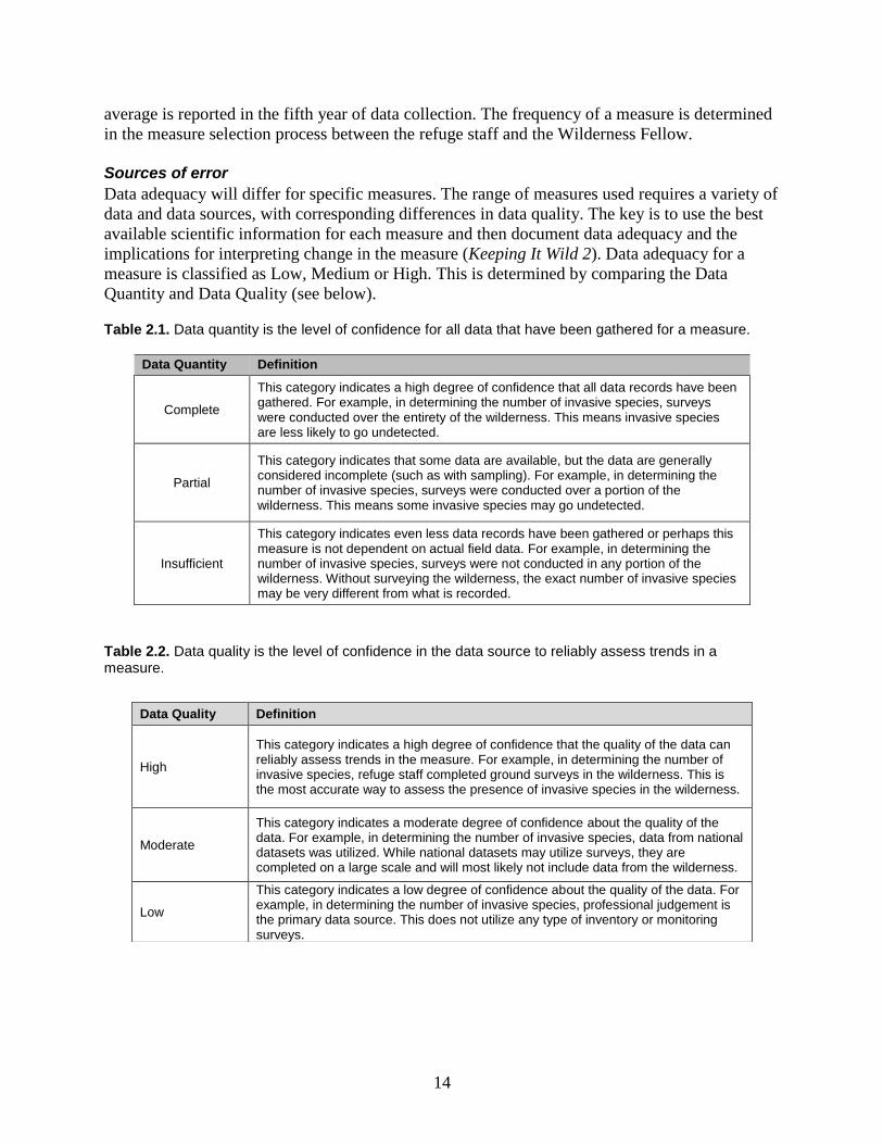
Sources of error
Data adequacy will differ for specific measures. The range of measures used requires a variety of
data and data sources, with corresponding differences in data quality. The key is to use the best
available scientific information for each measure and then document data adequacy and the
implications for interpreting change in the measure (Keeping It Wild 2). Data adequacy for a
measure is classified as Low, Medium or High. This is determined by comparing the Data
Quantity and Data Quality (see below).
Table 2.1. Data quantity is the level of confidence for all data that have been gathered for a measure.
Data Quantity Definition
Complete
This category indicates a high degree of confidence that all data records have been gathered. For example, in determining the number of invasive species, surveys were conducted over the entirety of the wilderness. This means invasive species are less likely to go undetected.
Partial
This category indicates that some data are available, but the data are generally considered incomplete (such as with sampling). For example, in determining the number of invasive species, surveys were conducted over a portion of the wilderness. This means some invasive species may go undetected.
Insufficient
This category indicates even less data records have been gathered or perhaps this measure is not dependent on actual field data. For example, in determining the number of invasive species, surveys were not conducted in any portion of the wilderness. Without surveying the wilderness, the exact number of invasive species may be very different from what is recorded.
Table 2.2. Data quality is the level of confidence in the data source to reliably assess trends in a measure.
Data Quality Definition
High
This category indicates a high degree of confidence that the quality of the data can reliably assess trends in the measure. For example, in determining the number of invasive species, refuge staff completed ground surveys in the wilderness. This is the most accurate way to assess the presence of invasive species in the wilderness.
Moderate
This category indicates a moderate degree of confidence about the quality of the data. For example, in determining the number of invasive species, data from national datasets was utilized. While national datasets may utilize surveys, they are completed on a large scale and will most likely not include data from the wilderness.
Low
This category indicates a low degree of confidence about the quality of the data. For example, in determining the number of invasive species, professional judgement is the primary data source. This does not utilize any type of inventory or monitoring surveys.
15
Field Methods and Processing of Collected Material
Organizational framework
This survey protocol framework is designed to be carried out by a limited refuge staff.
Wilderness character monitoring is intended to be conducted at the local level without an
increase in refuge personnel, with some assistance from regional and headquarters staff. The
measures chosen by the refuge are generally information collected for use in refuge management
or have been selected as a priority in the refuge Inventory and Monitoring Plan.
Keeping It Wild 2 outlines the following key principles that inform the refuge wilderness
character monitoring strategy:
The FWS is responsible for developing its own procedures to ensure implementation of
this monitoring strategy.
Wilderness character monitoring will provide credible data that will be directly useful for
tracking the outcomes of wilderness stewardship.
The baseline for evaluating trend in wilderness character is the time of wilderness
designation or the time of initiation of this monitoring program.
Trend in wilderness character is determined by change within an individual wilderness.
This monitoring balances national consistency with local relevance.
Trend in wilderness character is reported every 5 years for every wilderness.
Not all monitoring done in a wilderness is wilderness character monitoring.
Existing data are used whenever appropriate and available
Matching a measure with the appropriate quality of wilderness character
There are some measures where it is not immediately apparent under which quality they belong.
Most often this happens when deciding whether a measure should be included under the
Untrammeled Quality rather than the Natural or Undeveloped Quality. One rule of thumb is to
consider action versus effect versus presence. Untrammeled measures track actions to manipulate
the biophysical environment. Natural measures track the effects of human civilization on the
biophysical environment. Undeveloped measures track the presence of human structures in the
biophysical environment. Some wilderness threats could be monitored under multiple qualities,
depending on how the measure is designed. Each measure for a wilderness character attribute
usually should be used for only one indicator in order to avoid double counting. Therefore, the
primary concern behind the tracking of a particular threat to wilderness character should be
considered before designing a measure and assigning it to the appropriate quality.
While duplicate measures are discouraged, it is sometimes possible for multiple measures to
track the same threat, as long as each measure targets a different aspect of that threat. To put it
another way, a single action or condition can significantly threaten two wilderness qualities. For
example, if nest boxes are constructed with sufficient frequency to warrant long-term monitoring
in order to encourage population growth of an endangered bird, it would be an intentional
manipulation of the biophysical environment, and could be monitored as a measure under the
Untrammeled Quality. However, the boxes themselves could also be monitored as a measure of
the Undeveloped Quality as man-made structures. If both aspects were considered significant
threats to wilderness character, two measures could be used: 1) the number of actions to deploy
16
nest boxes (Untrammeled) and 2) the number of nest boxes within the wilderness (Undeveloped).
Moreover, as the threat to the endangered bird decreases, nest box deployment could be curtailed
thus not further degrading the Untrammeled Quality, while the boxes remain as installations.
Processing of collected materials
In most cases there are no physical materials collected in measures for wilderness character. In
the Natural Quality, material may be collected for identification, as for example with non-native
plants. When this occurs, materials will be saved or disposed of as determined by the established
procedure for such materials on the refuge. The principle of Leave No Trace applies to
wilderness character monitoring as it does for other wilderness activities. Therefore, all marking
of monitoring sites for particular measures should be minimized. End-of-season procedures
There is no field season associated with most wilderness character monitoring measures. Annual
measures generally follow the federal fiscal year unless the refuge stipulates that it will use the
calendar year.
17
Data Management and Analysis
Data entry, verification and storage
The survey of wilderness character monitoring is a data extensive exercise; the data collection
and storage in any single year generally takes a day or less, but the dataset over decades, gives a
powerful picture of changes occurring in the refuge wilderness. A typical wilderness character
monitoring survey averages 25 measures, selected by the refuge working with a Wilderness
Fellow. Data from some measures are collected annually, some over longer periods.
The measures that comprise the wilderness character monitoring survey were developed by a
Wilderness Fellow working on the refuge with refuge staff. Between 2011 and 2015, all refuges
with designated wilderness, and half of those with proposed wilderness, selected measures, and
conducted a baseline inventory of those measures. Those measures and data are in ServCat in the
Baseline Report for each wilderness refuge.
Starting in 2015, Wilderness Fellows contacted refuges again to review the wilderness character
monitoring. Recognizing changes that reflected the guidance in Keeping It Wild 2 as well as the
capacity of the refuge, some measures were eliminated and others modified. These changes were
documented in the refuge wilderness character monitoring Update Summary, signed by the
management leader at the refuge and the National Wilderness Coordinator. The Update
Summary details any new measures and provides initial data in an inventory of those measures.
In subsequent years, the annual data are stored as a ServCat record under the wilderness
character monitoring project associated with a refuge. Data security and archiving
Stations conducting wilderness character monitoring record it into PRIMR as a single annual
survey, and can use the Wilderness Character Monitoring Template for this purpose. In the first
year, the survey type is Baseline Monitoring (BM), and in subsequent years it is Monitoring to
Inform Management. The protocol and products are linked to the PRIMR record; the PRIMR
record is updated by refuge staff annually to note annual activity, usually data entry.
The annual data are stored as a product in ServCat, following the instructions in SOP 2. Storing
WCM data there fulfills two purposes. First, ServCat is the digital repository for important FWS
documents, including all relevant documents associated with wilderness. It provides a backup in
the event that locally stored files are lost. Second, it meets the accountability mandate of the
Inventory and Monitoring Policy, 701 FW 2: section 2.4 E, 2014.
The survey data are also stored in the interagency wilderness character monitoring database
accessible through wilderness.net. It provides redundancy to secure this long-term data, and it
also enables comparison of results among the four federal agencies that manage wilderness.
Instructions for uploading data to wilderness.net are in the addendum SOP 1, and can be
performed either by a refuge data steward or by regional or headquarters staff with access to the
data in ServCat.
Metadata
There are different data files associated with wilderness character monitoring, and each file type
has specific metadata to ensure that it is readily retrievable. The methods for storing WCM
18
Baseline Reports, Update Summaries, and dataset records in ServCat, are in SM 2: ServCat
Organization and Metadata template for WCM Projects & Products
Assessing wilderness character trends
The trend in wilderness character is derived hierarchically “to provide a readily interpretable
assessment for local, regional, and national staff” (Keeping It Wild 2). Trends in the qualities,
monitoring questions, indicators and measures of wilderness character are relevant to wilderness
managers, who may use this information to improve management at the local level. The
following guidelines explain how data are used to assign trends at each level of the wilderness
character hierarchy (Figure 2.1).
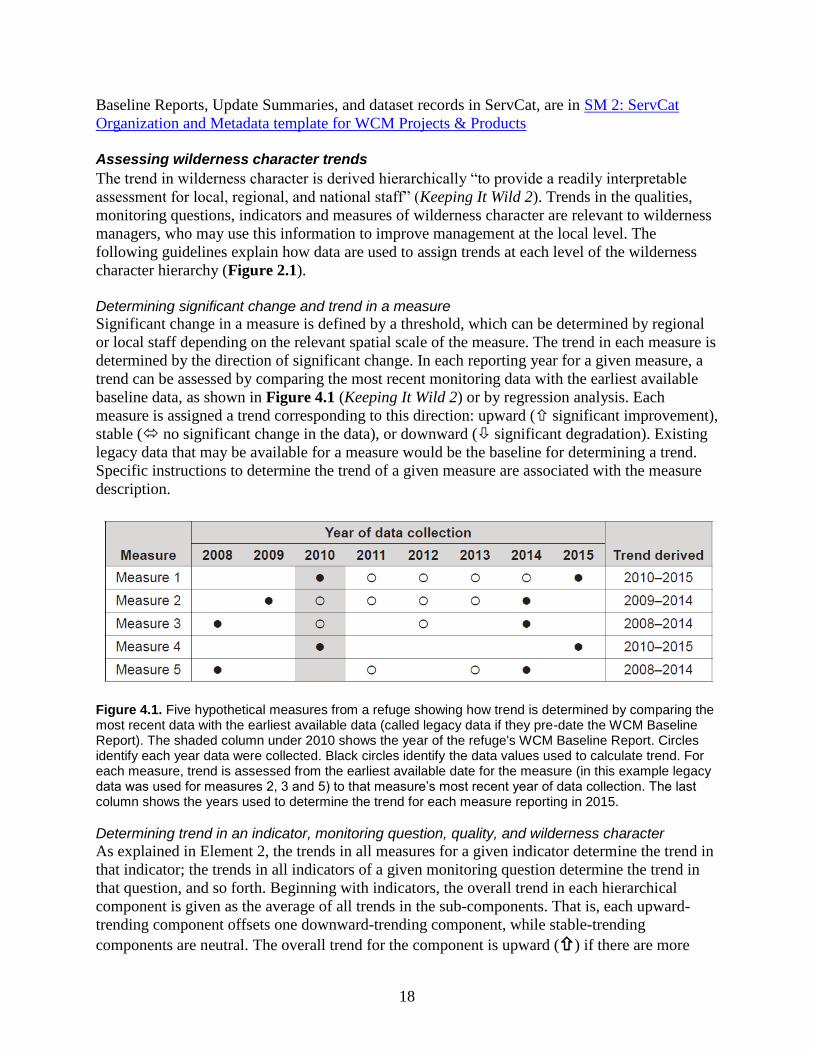
Determining significant change and trend in a measure Significant change in a measure is defined by a threshold, which can be determined by regional
or local staff depending on the relevant spatial scale of the measure. The trend in each measure is
determined by the direction of significant change. In each reporting year for a given measure, a
trend can be assessed by comparing the most recent monitoring data with the earliest available
baseline data, as shown in Figure 4.1 (Keeping It Wild 2) or by regression analysis. Each
measure is assigned a trend corresponding to this direction: upward ( significant improvement),
stable ( no significant change in the data), or downward ( significant degradation). Existing
legacy data that may be available for a measure would be the baseline for determining a trend.
Specific instructions to determine the trend of a given measure are associated with the measure
description.
Figure 4.1. Five hypothetical measures from a refuge showing how trend is determined by comparing the most recent data with the earliest available data (called legacy data if they pre-date the WCM Baseline Report). The shaded column under 2010 shows the year of the refuge's WCM Baseline Report. Circles identify each year data were collected. Black circles identify the data values used to calculate trend. For each measure, trend is assessed from the earliest available date for the measure (in this example legacy data was used for measures 2, 3 and 5) to that measure’s most recent year of data collection. The last column shows the years used to determine the trend for each measure reporting in 2015.
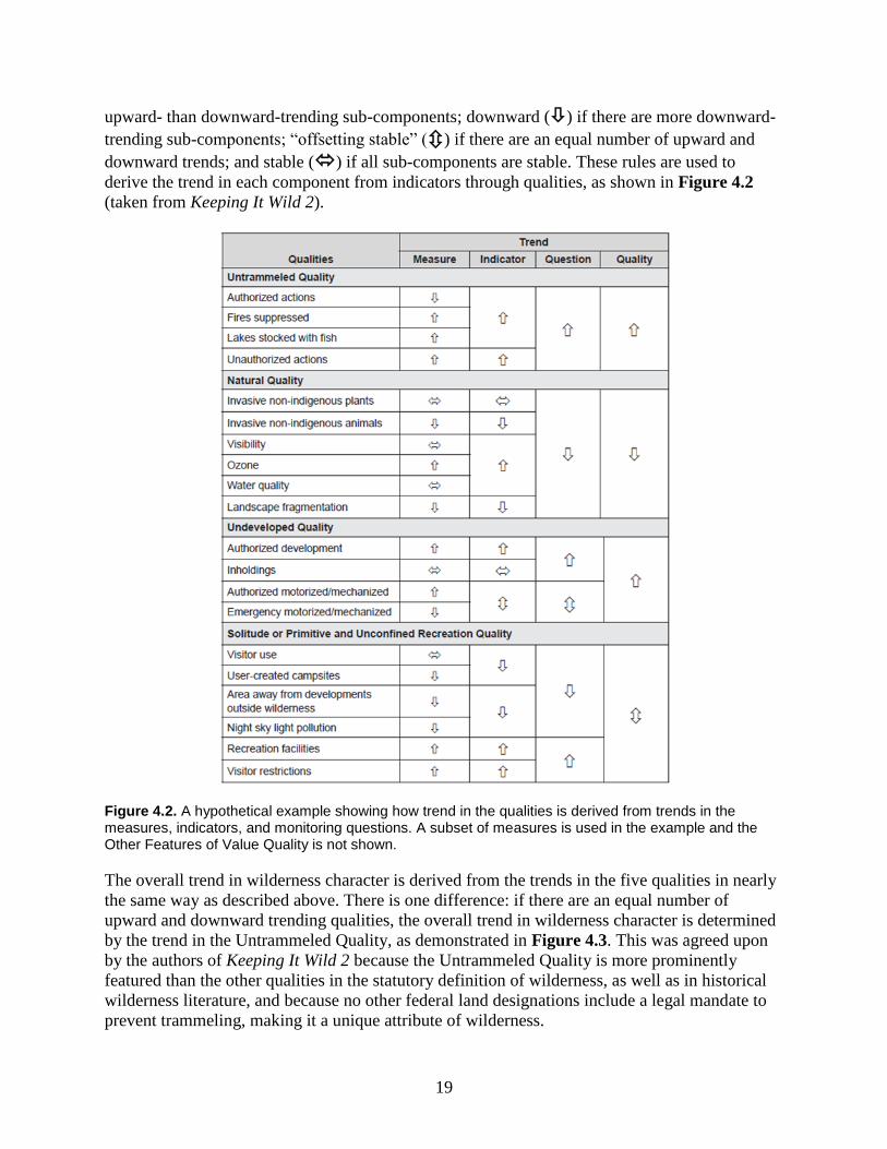
Determining trend in an indicator, monitoring question, quality, and wilderness character As explained in Element 2, the trends in all measures for a given indicator determine the trend in
that indicator; the trends in all indicators of a given monitoring question determine the trend in
that question, and so forth. Beginning with indicators, the overall trend in each hierarchical
component is given as the average of all trends in the sub-components. That is, each upward-
trending component offsets one downward-trending component, while stable-trending
components are neutral. The overall trend for the component is upward () if there are more
19
upward- than downward-trending sub-components; downward () if there are more downward-
trending sub-components; “offsetting stable” () if there are an equal number of upward and
downward trends; and stable () if all sub-components are stable. These rules are used to
derive the trend in each component from indicators through qualities, as shown in Figure 4.2
(taken from Keeping It Wild 2).
Figure 4.2. A hypothetical example showing how trend in the qualities is derived from trends in the measures, indicators, and monitoring questions. A subset of measures is used in the example and the Other Features of Value Quality is not shown.
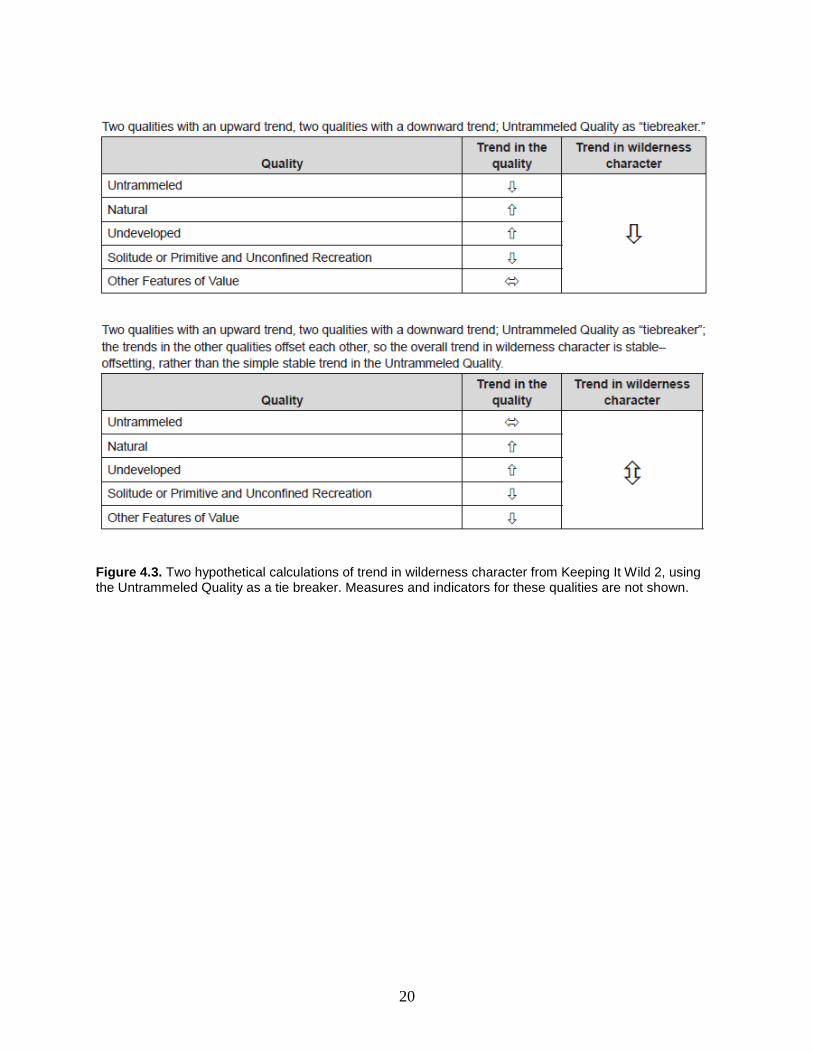
The overall trend in wilderness character is derived from the trends in the five qualities in nearly
the same way as described above. There is one difference: if there are an equal number of
upward and downward trending qualities, the overall trend in wilderness character is determined
by the trend in the Untrammeled Quality, as demonstrated in Figure 4.3. This was agreed upon
by the authors of Keeping It Wild 2 because the Untrammeled Quality is more prominently
featured than the other qualities in the statutory definition of wilderness, as well as in historical
wilderness literature, and because no other federal land designations include a legal mandate to
prevent trammeling, making it a unique attribute of wilderness.
20
Figure 4.3. Two hypothetical calculations of trend in wilderness character from Keeping It Wild 2, using the Untrammeled Quality as a tie breaker. Measures and indicators for these qualities are not shown.
21
Reporting
WCM Baseline Report
The WCM Baseline Report details the measures and collection protocols specific to a refuge
wilderness. They were developed by a Wilderness Fellow working with refuge staff to define the
initial measures that constitute WCM on the refuge wilderness. It is the initial report for a refuge
that used KIW as guidance to select measures and represents the first year of WCM for a
wilderness. In addition to the measure descriptions and collection protocols, the WCM Baseline
Report provides the historical and biophysical setting of the wilderness. Putting that monitoring
into effect resulted in learning by all four agencies involved; it led to new interagency guidance,
Keeping It Wild 2 which updated the methods for conducting wilderness character monitoring.
To consider the guidance from KIW2 and review the relevance of measures after the initial
refuge wilderness character monitoring, the Baseline Report has been supplemented with an
Update Summary.
WCM Update Summary
The WCM Update Summary, is consistent with the KIW2 guidance and details the modified
measures and collection protocols specific to a refuge wilderness. Wilderness Fellows worked
with refuge staff in writing the Update Summary that defined the final WCM measures carried
out by refuge staff. The WCM Update Summary provides details about any modified or replaced
measures from the WCM Baseline Report, with the rationale for those changes. It also provides
collected data values for the final measures since the time of the WCM Baseline Report.
WCM Dataset
The WCM Dataset is created by the wilderness data steward after the WCM Baseline Report and
WCM Update Summary are completed. It provides an annual report of data values for the
scheduled measures of a wilderness, across a 5-year period. The wilderness data steward will use
the WCM Dataset Template every monitoring year to enter data values for their wilderness and
will archive the dataset into the FWS Service Catalog (ServCat). The 5-year ranges start with
2015-2019. The collected data values in the data report will also be referenced for data entry into
the WCM Database at the end of every monitoring year.
Reporting on trend in wilderness character
Agencies can produce three types of standardized reports to summarize wilderness character
monitoring data; they are designed for local, regional, and national audiences, respectively.
These reports are intended to help managers understand the ongoing changes in wilderness
character, as well as the regional and national trends in the wilderness stewardship strategies of
the wilderness-managing agencies. The three monitoring reports are created in the interagency
WCM Database. Although the Refuge System is responsible for determining its own report
content and format, sufficient interagency consistency should allow for the production of a single
NWPS summary report.
Local wilderness report
This wilderness-specific report promotes understanding of wilderness conditions and facilitates
discussion among refuge and regional staff about preserving wilderness character. Keeping It
Wild 2 suggests two types of agency-specific local reports. A summary report would present
trends in wilderness character and the qualities to a broad audience of decision makers and
22
interested citizens, and would be used for upward reporting within the Fish and Wildlife Service.
A detailed report would present all the wilderness character monitoring information from the
data for each measure and then provide the overall trend in wilderness character. The refuge staff
can generate and use this report to compare current conditions with locally established
thresholds.
Regional wilderness report
The goal of this report is to promote communication and discussion of monitoring results among
the agency’s regional managers. A standardized reporting format would show trends in
wilderness character – that is trends in the qualities, monitoring questions and indicators – for all
of the wilderness areas in a region. Refuge regional reports will not include information on the
measure level because each wilderness will have some unique measures. The regional wilderness
report will include a map to show the percentage of wildernesses within each region that are
preserving or improving wilderness character. This report will provide the level of detail regional
program managers need to help with accountability for wilderness stewardship and policy
review.
National wilderness report
This report promotes communication and discussion of wilderness stewardship among national
wilderness program managers and coordinators within each agency, key national non-
governmental partners, and congressional staff. A standardized reporting format will show, in
approximately two pages, the agency-specific national summary of monitoring results suitable
for high-level briefings. This report will present the overall percentage of wildernesses in the
NWPS in which wilderness character is improving, and the national trend for each of the
qualities of wilderness character.
Report content recommendations
Keeping It Wild 2 suggests that a monitoring narrative is included in each report. It provides
relevant information about the local, regional, and national conditions, circumstances, and
context that affect the interpretation and use of the trends reported.
Objectives and methods
All survey reports include information about the objectives and methods to communicate the
justification and purpose for conducting WCM. This text can be summarized from Element 1 and
2 and should be included in the site specific protocol, cited appropriately. Document any changes
in methodology during the monitoring year, including trend reporting and analysis resources.
Summary of results
A summary can identify the trends for the qualities and the data sources that contribute to those
results. The depth of the summary depends on the scale and audience. The refuge level detailed
report would include data from each measure of the indicators, the qualities and the overall trend
in wilderness character. This section can include tables or graphs such as the wilderness reports
generated from the WCM Database.
23
Important findings
This portion of the report gives staff the opportunity to add qualitative information and insights
from their professional judgment to complement and help interpret trends as appropriate for
local, regional, and national reporting. This text would be a valuable part of the legacy
information passed to future wilderness managers and would help ensure consistency in
reporting over time. The following questions could serve to structure this narrative: Is there
confidence in the data generated by this monitoring? Does the trend in wilderness character
accurately reflect recent conditions in the wilderness? How should the trend in wilderness
character be interpreted if some of the qualities are showing an upward trend while others are
showing a downward trend? Have decisions been made (for example, to not take certain actions)
that are not reflected in this monitoring but that affect the interpretation of the trend in wilderness
character? Reporting schedule
WCM datasets
Measure data values for each measure are reported annually at the end of each monitoring year
as defined in the specific refuge collection protocol and entered in ServCat as described in
SOP 2: Entering Wilderness Character Monitoring Data in ServCat.
Local wilderness reports
Standardized monitoring reports for the local level can be produced annually or biannually. The
reports can be used to compare results from previous years and generate discussion of
management actions affecting particular indicators. They can also be used to compare a
wilderness refuge to other wilderness areas, some managed by other agencies, to gauge how a
refuge contributes to the National Wilderness Preservation System.
Regional and national wilderness reports
Regional and national standardized monitoring reports are produced once every five years.
Regional reports are a collaboration of the Regional Wilderness Coordinator and regional I&M
personnel. National reports are the responsibility of the National Wilderness Coordinator
working with headquarters I&M personnel.
24
Personnel Requirements and Training
Wilderness character monitoring is accomplished through collaborative efforts of FWS personnel
at the refuge, regional and national levels. Following are the roles and responsibilities for
particular positions that are critical to the initiation and implementation of wilderness character
monitoring.
Roles and responsibilities
Inventory and Monitoring (I&M) Branch
The I&M Branch is part of the Natural Resource Program Center and is responsible for the data
integrity and tracking of surveys conducted on refuges in the National Wildlife Refuge System.
The Branch maintains the Planning and Review of Inventory and Monitoring at Refuges
(PRIMR) Database, which describes and archives the surveys conducted on each refuge,
including wilderness character monitoring. The I&M Branch also manages the Service Catalog
(ServCat), the digital repository for complete documents associated with those surveys. It is the
responsibility of Regional I&M Data Managers to ensure that wilderness character monitoring
surveys and the data derived from them are consistently entered into ServCat and PRIMR.
National Air Quality Specialist
Responsible for collecting nation-wide air quality data and distributing it to the refuges at five
year intervals that comprise the four air quality measures (visibility, total sulfur wet deposition,
total nitrogen wet deposition, and ozone air pollution) for the Natural Quality of wilderness
character.
National Wilderness Coordinator
As the person with overall responsibility for WCM on refuges, the National Wilderness
Coordinator works with the Inventory and Monitoring Branch, the Refuge Manager and often a
Wilderness Fellow to determine relevant measures for the wilderness character monitoring
survey on a particular refuge. The National Wilderness Coordinator and Refuge Manager or
Project leader sign off on the Update Summary stating the WCM measures for the refuge. The
National Wilderness Coordinator is responsible for checking with Regional Wilderness
Coordinators to assure the wilderness character monitoring survey data are collected. Working
with the I&M Branch, the National Wilderness Coordinator is responsible for a national
Wilderness Character Monitoring report summarizing the data every five years.
Regional Wilderness Coordinator
The Regional Wilderness Coordinator helps to assure that wilderness character monitoring is
carried out on the wilderness refuges of that region. The Regional Wilderness Coordinator
maintains a list with point-of-contact for each wilderness refuge to inquire about the completion
of WCM data entry and tracking in PRIMR. Regional Wilderness Coordinators work with
regional I&M staff to ensure a common understanding of the WCM data collection process.
Working with the Regional I&M Coordinator, data managers and other staff, each Regional
Wilderness Coordinator is responsible for a regional Wilderness Character Monitoring report
summarizing the data every five years.
25
Refuge Supervisor
Refuge Supervisors are responsible for providing guidance and ensuring compliance with our
policies on wilderness stewardship and inventory and monitoring. Supervisors will work with
their Regional Wilderness Coordinator to assure that wilderness character is regularly monitored
and the data are regularly entered.
Project Leader or Refuge Manager
The Project Leader is responsible for the selection and final approval, with the National
Wilderness Coordinator, of all measures for the wilderness character monitoring survey for the
refuge. Working with a Wilderness Fellow, measures are selected and updated in the Update
Summary. The Project Leader is a signatory of the Update Summary, and is responsible for
ensuring that the data for final measures selected are reported accurately and on time.
The Survey Coordinator
The Survey Coordinator is responsible for executing the WCM survey and entering the data for
the measures in the Update Summary into ServCat. He or she serves as the Wilderness Data
Steward unless other refuge or regional personnel has been assigned that role. If any changes in
WCM measures are warranted, the Survey Coordinator proposes those changes to the refuge
Project Leader and National Wilderness Coordinator for approval.
Wilderness Data Steward
The person, designated in the Update Summary, responsible for annual WCM data entry into
ServCat and the Wilderness Character Monitoring Database.
Wilderness Fellow
A person trained in the theory and application of wilderness character monitoring who helps
develop the WCM measures for a refuge. Wilderness Fellows work with refuge staff to develop
both the WCM Baseline Reports and Update Summaries that define the WCM measures for the
refuge. Working with Project Leaders, Refuge Managers, the National Wilderness Coordinator
and the I&M Branch, Wilderness Fellows determine locally relevant measures for wilderness
character monitoring.
Qualifications
Wilderness Fellows all have college degrees, usually in the natural sciences and are selected
through a competitive process of resume evaluation and interviews. All of the other personnel
involved in wilderness character monitoring are qualified through selection as part of their Fish
and Wildlife Service duties.
Training
Wilderness Fellows receive in-person training by agency wilderness authorities in the history and
application of the Wilderness Act. They are specifically taught about the tenets of Keeping It
Wild 2¸and how to develop and conduct wilderness character monitoring. Other personnel with a
role in wilderness character monitoring at the national, regional and refuge levels have different
training options. They can apply to attend the in-person Wilderness Fellows' WCM training; they
can access the Wilderness Character toolbox and find general information on wilderness
26
character, and a PowerPoint on monitoring at Wilderness Connect. Also, the Carhart Center
offers periodic webinars on specific wilderness monitoring topics; and the Refuge System I&M
Branch presents periodic webinars on WCM, as needed.
4. Click the second tab, Enter/Edit Measure Values, to identify the expected years for data
reporting by referring to the Year of Measure Value column (Figure SOP 1.2). The
year referenced in Next is the year the measure is due for reporting.
Figure SOP 1.2. The Enter/Edit Measure Values tab shows the active measures for data reporting using Brigantine Wilderness as a hypothetical example. The Next reporting year for the “Index of human disturbances to nesting shorebirds and waterfowl” Measure is 2017.
5. Identify all of the measure values due for reporting in the monitored year before logging
out of the database.
6. Collect the measure values throughout the monitoring year following the station’s
protocol for collecting WCM data.
Entering data in the interagency WCM Database
1. When the measure values have been collected at the end of the monitoring year, log into
https://wc.wilderness.net with your username and password.
2. Select your wilderness for data entry from the WCM home screen.
3. Click Select Measures/Enter Data then in the third row, click the second tab Enter/Edit
Measure Values.
4. On the Enter/Edit Measure Values tab, find the expected measure and click Add/Edit
Data. If this is the first data value entered for the measure, it will automatically open the
Add Measure Value screen that will allow you to enter data. If this is for additional data
values, it will open the Data Entry home screen (Figure SOP 1.3).
Figure SOP 1.3. The Data Entry home screen for the selected measure shows the measure values that have been entered with the option to Add Another Year or Edit/View an existing measure value.
1. From the Data Entry home screen, click Add Another Year for the Add Measure Value
screen (Figure SOP 1.4) to enter another year of data.
32
Figure SOP 1.4. The Add Measure Value screen for the selected measure can be populated with the measure value and information for the year of data collection.
2. Enter your data for the measure, including the following required fields:
Year of Data Collection
Value
Data Adequacy
If the information is similar to the previous monitoring year, clicking Populate form with data
from last monitored year will save time in data entry. When using this function, check all fields
for accuracy.
3. After entering all pertinent information, click Save to complete data entry for the measure.
This will redirect you to the Enter/Edit Measure Values tab showing all of the active
measures.
4. Confirm data entry was completed for the monitored year by checking the Last year shown in
the Year of Measure Value column for the measure (Figure SOP 1.5).
33
Figure SOP 1.5. In reference to Figure SOP 1.2, this figure shows the Next collection year for the selected measure has changed from 2017 to 2018 and the Last measure value entered changed from 2016 to 2017.
5. To confirm the value for the measure was entered correctly, click Add/Edit Data to view the
Data Entry home screen (Figure SOP 1.6).
Figure SOP 1.6. In reference to Figure SOP 1.3, this figure shows the Data Entry home screen for the selected measure and the added measure value of 190 with a Downward Trend for monitoring year 2017.
6. Continue the data entry for all scheduled measures in the monitoring year.
7. Log out of the WCM database. When data entry for the WCM measures for the monitoring
year is completed, it can be noted on the Enter Annual Activity page of the PRIMR database.
34
SOP 2: Entering Wilderness Character Monitoring Data in ServCat
Materials
1. Refuge WCM Baseline Report
2. Refuge WCM Update Summary
3. WCM Dataset Template (ServCat 98174)
4. ServCat Organization and Metadata Template for WCM Projects & Products (SM 2)
Gathering the WCM data values
Consult the WCM Baseline Report and Update Summary, if completed, for data collection
protocols for individual measures. These reports can be downloaded from ServCat in the
respective wilderness-specific project associated with the Wilderness Character Monitoring
Initiative Program 5706.
1. Use the WCM Summary Table provided in the Update Summary, to identify the final
selected measures for the wilderness.
2. Refer to the Narrative of the Update Summary for details of the measures that have been
modified, added, or removed from the WCM Baseline Report.
3. Measures that differ from the WCM Baseline Report are found in the Measure Description
section of the Update Summary. Likewise, measure descriptions and collection protocols that
are not found in the Update Summary can be found in the WCM Baseline Report.
Pay close attention to the Measure Description and Collection Protocol section for each
measure.
Data reporting frequencies for the individual measures are outlined in the WCM Baseline Report
and Update Summary. Some WCM measures will have data reported annually, and some
measures require data reported at 5 or 10 year frequencies. The frequencies for all of the
measures are in the WCM Summary Table of the refuge Update Summary. If a data value has
not been reported in five years for a measure with a 5-year frequency, then that data value is
collected in addition to all of the annual measures. Table SOP 2.1 shows an example of three
measures in the Natural Quality. Each measure has a 5-year frequency, but the baseline year for
the measures “Number of invasive plants species” and “Number of invasive animal species” is
2012, while the baseline year for “Ozone air pollution” is 2009. Therefore, in 2017 data are
reported for the first two measures, but not for the last measure, which will be reported in 2019.
Table SOP 2.1. Example of how to use the WCM Dataset Template for measures that are not scheduled for data reporting based on a measure’s frequency and baseline year.
XXXX Wilderness WCM Baseline Year: 2012
Quality Measure Frequency Baseline Year
Baseline Value 2017 Value
Natural Number of invasive plant species
5 years 2012 2 1
Number of invasive animal species
5 years 2012 3 3
Ozone air pollution
5 years 2009 77 ppb (Significant concern)
N/A
Filling out the WCM Dataset Template
Once the measure description and collection protocols are consulted, collected data values are
entered in the WCM Dataset Template (see SM 1: WCM Dataset Example). As a convention, the
titles of columns are in bold and the contents of columns are in italics.
1. Download the latest WCM Dataset Template from ServCat and use the most current measure
description and collection protocols for template details.
2. Fill in the name of the wilderness and the baseline year for WCM in the top row of the
template.
3. In the Measure column, fill in the measure titles based on the measures identified in the
most current measure description and collection protocols. Additional rows can be added to
the template where needed.
4. In the Frequency column, fill in the identified frequency for the individual measures. Some
typical frequencies are annually, 5 years, and 10 years.
5. In the Baseline Year column, fill in the baseline years for each individual measure.
Measure baseline years are not always the same as the baseline year of wilderness character
monitoring for an individual wilderness. For example, if the WCM Baseline Report was
completed in 2012, the wilderness character monitoring baseline year is 2012. Exceptions to
this are the four standard air quality measures: "Ozone air pollution," "Total nitrogen wet
deposition," "Total sulfur wet deposition," and "Visibility." Because these measures come
from a national monitoring initiative, the years of data reporting are set by that initiative. In
this case, the baseline year for these four measures is 2009.
6. In the Baseline Value column, fill in the baseline values for each measure. The baseline
values will be found in the WCM Baseline Report and the Update Summary.
Potential restructuring of wilderness character monitoring measures
The purpose of this strategy is to provide a way to summarize the suggested changes to wilderness character monitoring (WCM) for Mollie
Beattie Wilderness to be compliant with changes made to the interagency strategy Keeping It Wild (2008). Measures selected in the 2013
Baseline WCM Report implemented guidance in the original strategy and needs to be updated to reflect the new strategy, Keeping It Wild 2
(KIW2) (2015). There are three major changes:
1. KIW2 clarifies that measures in the Untrammeled Quality should track the individual actions that intentionally manipulate wilderness
and not the magnitude of those actions (pp. 34-35). This shift in focus allows measures in this quality to get at the decision to manipulate
a wilderness.
2. The Natural Quality, which previously had three indicators in Keeping It Wild (“plants and animal species and communities,” “physical
resources,” and “biological processes”), now has four indicators in KIW2: “plants,” “animals,” “air and water,” and “ecological
processes.” Additionally, KIW2 clarifies that measures should look at human-caused threats to native species and communities (p. 40).
KIW2 encourages wildernesses to move away from native species population dynamic measures, since native species cannot be a threat
to the Natural Quality.
3. The Other Features of Value Quality was added to account for cultural sites, paleontological sites, or other features of value integral to
wilderness character. Measures in this new quality and its associated indicators will replace the measures that were used in the “Loss of
statutorily protected cultural resources” indicator previously under the Undeveloped Quality. The Other Features of Value Quality is the
only optional quality, as these types of features may or may not be present in a wilderness.
Below is a table displaying a potential strategy for reorganizing the existing Mollie Beattie wilderness character monitoring measures to comply
with KIW2.
During this process, data values for these measures will be collected for data entry into the interagency Wilderness Character Monitoring
Database.
56
QUALITY INDICATOR MEASURES COMMENT
Untrammeled Actions authorized by the federal land manager that intentionally manipulate the biophysical environment
Number of actions to manipulate plants, wildlife, insects, or fish (2013 Baseline Report, p. 20)
N/A
Untrammeled Actions authorized by the federal land manager that intentionally manipulate the biophysical environment
Index of fire management actions in wilderness (2013 Baseline Report, pp. 21-22)
This measure takes into account the magnitude of the suppression response, which KIW2 moves away from (p. 35). Suggest counting all actions equally. Suggested measure: Number of actions to manage fire in wilderness
Untrammeled Actions authorized by the federal land manager that intentionally manipulate the biophysical environment
Number of research, survey, and monitoring projects that manipulate plants, wildlife or habitat (2013 Baseline Report, p. 23)
N/A
Untrammeled Actions not authorized by the federal land manager that intentionally manipulate the biophysical environment
Number of unauthorized actions to manipulate plant, wildlife, insects, fish, pathogens, soil, water, or fire (2013 Baseline Report, p. 24)
N/A
Untrammeled Actions not authorized by the federal land manager that intentionally manipulate the biophysical environment
Number of hunting regulations with clear intent to manipulate predator populations inside wilderness (2013 Baseline Report, pp. 25-26)
Suggest counting the actions instead of regulations. Suggested measure: Number of actions to manipulate predator populations
Natural Plants Number of non- native plant, animal and pathogen species (2013 Baseline Report, p. 28)
The indicators were changed in KIW2. This measure can be split up so that each indicator is represented. Also, the terminology we are using is invasive, can we add that to the title? Suggested measure: Number of non-native, invasive plant species
Natural Animals N/A Suggested measure: Number of non-native, invasive animal species
Natural Air & water N/A Measures need to be developed.
57
QUALITY INDICATOR MEASURES COMMENT
Natural Ecological processes Vegetation greenness and length of growing season indicator of climate change (2013 Baseline Report, p. 29)
Moved from Biophysical Processes. Suggested measure to add to Ecological Processes: Number of non-native, invasive pathogens
Undeveloped Presence of non-recreational structures, installations, and developments
Index of authorized physical structures, installations, or developments (2013 Baseline Report, p. 31)
N/A
Undeveloped Presence of non-recreational structures, installations, and developments
Index of Collars, and both visible and not visible transmitters in the wilderness (2013 Baseline Report, p. 32)
Undeveloped Inholdings Index of inholdings within wilderness (2013 Baseline Report, p. 33)
N/A
Undeveloped Use of motor vehicles, motorized equipment, or mechanical transport
Number of authorized helicopter uses (2013 Baseline Report, p. 34)
N/A
Undeveloped Use of motor vehicles, motorized equipment, or mechanical transport
Air Taxi and Transporter fixed wing aircraft use (2013 Baseline Report, p. 35)
N/A
Undeveloped Use of motor vehicles, motorized equipment, or mechanical transport
Number of fixed wing aircraft landing sites (2013 Baseline Report, pp. 36-37)
N/A
Undeveloped Use of motor vehicles, motorized equipment, or mechanical transport
Authorized motor and mechanical use (2013 Baseline Report, p. 38)
N/A
Outstanding Opportunities for Solitude or Primitive and Unconfined Recreation
Remoteness from sights and sounds of human activity inside of wilderness
Visitor Study Count of other groups encountered by visitors (2013 Baseline Report, p. 41)
Suggest reducing or combining measures in this indicator. Could be combined with “Visitor Study Count of encounters with refuge staff or other law enforcement”.
Outstanding Opportunities for Solitude or
Remoteness from sights and sounds of human activity inside of wilderness
Visitor Study Count of the # of air planes Encountered (2013 Baseline Report, p. 42)
Suggest reducing or combining measures in this indicator.
58
QUALITY INDICATOR MEASURES COMMENT
Primitive and Unconfined Recreation
Suggest replacing “#” with “Number”.
Outstanding Opportunities for Solitude or Primitive and Unconfined Recreation
Remoteness from sights and sounds of human activity inside of wilderness
Visitor Study Count of Evidence of other visitors’ impacts (2013 Baseline Report, p. 43)
Suggest reducing or combining measures in this indicator.
Outstanding Opportunities for Solitude or Primitive and Unconfined Recreation
Remoteness from sights and sounds of human activity inside of wilderness
Visitor Study Count of encounters with refuge staff or other law enforcement (2013 Baseline Report, p. 44)
Suggest reducing or combining measures in this indicator. Could be combined with “Visitor Study Count of other groups encountered by visitors”.
Outstanding Opportunities for Solitude or Primitive and Unconfined Recreation
Remoteness from sights and sounds of human activity inside of wilderness
Number of abandoned property or trash sites inside the wilderness (2013 Baseline Report, p. 45)
Suggest reducing or combining measures in this indicator.
Outstanding Opportunities for Solitude or Primitive and Unconfined Recreation
Remoteness from sights and sounds of human activity inside of wilderness
Visitor use days at select high traffic sites (2013 Baseline Report, p. 46)
Suggest reducing or combining measures in this indicator.
Outstanding Opportunities for Solitude or Primitive and Unconfined Recreation
Remoteness from sights and sounds of human activity inside of wilderness
# of commercial guides in wilderness (2013 Baseline Report, p. 47)
Suggest reducing or combining measures in this indicator. Suggest replacing “#” with “Number”.
59
QUALITY INDICATOR MEASURES COMMENT
Outstanding Opportunities for Solitude or Primitive and Unconfined Recreation
Remoteness from sights and sounds of human activity outside of wilderness
Viewshed impacts from developed areas outside the wilderness (2013 Baseline Report, p. 48)
N/A
Outstanding Opportunities for Solitude or Primitive and Unconfined Recreation
Facilities that decrease self-reliant recreation
Agency-provided facilities in the wilderness that decrease self-reliant recreation (2013 Baseline Report, p. 49)
N/A
Outstanding Opportunities for Solitude or Primitive and Unconfined Recreation
Facilities that decrease self-reliant recreation
Number of sites with obvious visitor created trails in wilderness (2013 Baseline Report, p. 50)
N/A
Outstanding Opportunities for Solitude or Primitive and Unconfined Recreation
Management restrictions on visitor behavior
Management restrictions on non-commercially guided visitors (2013 Baseline Report, p. 51)
N/A
Other Features of Value
Deterioration or loss of integral historical or cultural features
N/A
Other Features of Value
Deterioration or loss of other integral site-specific features of value
N/A
U.S. Fish and Wildlife Service U.S. Department of the Interior National Wildlife Refuge System