New South Wales Surveying and Spatial Information Regulation 2017 under the Surveying and Spatial Information Act 2002 Published LW 1 September 2017 (2017 No 486) His Excellency the Governor, with the advice of the Executive Council, has made the following Regulation under the Surveying and Spatial Information Act 2002. VICTOR DOMINELLO, MP Minister for Finance, Services and Property Explanatory note The object of this Regulation is to remake, with minor amendments, the provisions of the Surveying and Spatial Information Regulation 2012, which is repealed on 1 September 2017 by section 10 (2) of the Subordinate Legislation Act 1989. The Regulation includes provisions about the following aspects of the carrying out of surveys and the preparation of survey plans: (a) the duties of surveyors, (b) the adoption of datum lines and benchmarks, (c) measurements and calculations involved in surveys, (d) the use of survey marks and monuments, (e) surveys of boundaries formed by tidal and non-tidal waters and other natural features, (f) the making and keeping of field notes, (g) the format and contents of survey plans, (h) public surveys. The Regulation also includes provisions about the following: (a) the constitution of the Board of Surveying and Spatial Information, and committees established to assist that Board, (b) the registration of surveyors, including necessary qualifications and conditions of registration, (c) the keeping of the Register of surveyors, (d) complaints against registered surveyors, (e) fees for services and deposits payable in relation to the deferment of placement of survey marks. This Regulation is made under the Surveying and Spatial Information Act 2002, including sections 3, 4, 5, 7, 10, 26, 27 and 36 (the general regulation-making power).
Transcript
New South Wales
Surveying and Spatial Information Regulation 2017under the
Surveying and Spatial Information Act 2002
Published LW 1 September 2017 (2017 No 486)
His Excellency the Governor, with the advice of the Executive Council, has made the following Regulation under the Surveying and Spatial Information Act 2002.
VICTOR DOMINELLO, MPMinister for Finance, Services and Property
Explanatory noteThe object of this Regulation is to remake, with minor amendments, the provisions of the Surveying and Spatial Information Regulation 2012, which is repealed on 1 September 2017 by section 10 (2) of the Subordinate Legislation Act 1989.The Regulation includes provisions about the following aspects of the carrying out of surveys and the preparation of survey plans:
(a) the duties of surveyors,
(b) the adoption of datum lines and benchmarks,
(c) measurements and calculations involved in surveys,
(d) the use of survey marks and monuments,
(e) surveys of boundaries formed by tidal and non-tidal waters and other natural features,
(f) the making and keeping of field notes,
(g) the format and contents of survey plans,
(h) public surveys.The Regulation also includes provisions about the following:
(a) the constitution of the Board of Surveying and Spatial Information, and committees established to assist that Board,
(b) the registration of surveyors, including necessary qualifications and conditions of registration,
(c) the keeping of the Register of surveyors,
(d) complaints against registered surveyors,
(e) fees for services and deposits payable in relation to the deferment of placement of survey marks.This Regulation is made under the Surveying and Spatial Information Act 2002, including sections 3, 4, 5, 7, 10, 26, 27 and 36 (the general regulation-making power).
ContentsPage
Surveying and Spatial Information Regulation 2017 [NSW]Contents
Part 1 Preliminary1 Name of Regulation 52 Commencement 53 Application of Regulation 54 Mining surveys 55 Definitions 5
Part 2 Survey practice
Division 1 General duties of surveyor
6 General principles of survey 97 Surveyor to obtain information 98 Surveyor to meet requisitions 99 Surveys not requiring strict accuracy 9
10 Surveys for identification or re-marking 911 Effect of contravention of Part 10
Division 2 Adoption of datum lines and bench marks
12 Datum line 1013 Bench marks 11
Division 3 Measurement and calculations
14 Equipment for measurement of surveys 1215 Measurement of boundaries and lines 1216 Measurement by remote-sensing methods 1217 Confirming terminals where part only of land to be surveyed 1218 Surveys for affecting interests 1219 Re-survey of property boundaries 1320 Survey where boundary includes crooked fence 1421 Calculation of areas of land 1422 Surveys using GNSS equipment 1423 Accuracy of angular measurements 1424 Accuracy of length measurements 1525 Accuracy of relative position 1526 Checking accuracy of measurements and calculations 15
Division 4 Use of survey marks and monuments
Subdivision 1 Surveys generally
27 Forms and styles of survey marks 1628 Boundary marks 1629 Marking of urban surveys 1730 Marking of rural surveys 1731 Roads to be marked with reference marks 1832 Procedure on finding existing corner peg and reference mark 1933 Procedure if monuments of original survey missing 1934 Procedure if differences exist between measured and recorded lengths 1935 Surveyor to note nature and position of survey marks etc 19
Page 2 Published LW 1 September 2017 (2017 No 486)
Surveying and Spatial Information Regulation 2017 [NSW]Contents
Page
36 Placement of reference marks 2037 Use of broad arrows 2038 Deferment of placement of survey marks 2039 Surveyor to report position of permanent survey marks 20
Subdivision 2 Surveys to be lodged with Registrar-General or public authorities
40 Application 2041 Surveys redefining or creating multiple parcels, roads or affecting
interests 2042 Connection to permanent survey marks 2143 New permanent survey marks 21
Division 5 Boundaries formed by tidal and non-tidal waters and other natural features
44 Definitions 2245 First survey of boundary of land adjoining Crown reserve or Crown
road 2246 First survey of mean-high water mark boundary or bank 2347 Surveys where boundary includes tidal or non-tidal waters or other
natural feature 2348 Changes in boundaries formed by tidal waters 2449 Changes in boundaries formed by lakes, streams and natural features 2550 Surveyor to report on certain determinations 2551 References to high-water mark and tidal waters in previous survey
plans 25
Division 6 Field notes
52 Surveyor to make field notes 2653 Surveyor to retain electronic records 2654 Surveyor to record datum line in field notes 2655 Surveyor to record landmarks in field notes 2656 Surveyor to sign and date field notes 2657 Method of recording angles and bearings 27
Division 7 Survey plans
58 Medium and format of survey plans 2759 Method of showing bearings and distances 2760 Survey plan to indicate name of locality, street address and type of
survey 2761 Method of recording datum line 2762 Use of reference marks 2863 Method of showing boundaries generally 2864 Method of showing natural feature boundaries 2865 Surveys of land adjoining tidal waters 2966 Survey plan to show GNSS validation 2967 Conventional signs and symbols to be used on survey plans 2968 Surveyor to report on doubts, discrepancies and difficulties 2969 Survey plan to show height difference schedule 2970 Survey plan to show coordinate schedule 2971 Survey plan to show height schedule 3072 Surveyor to furnish survey certificate 31
Page 3 Published LW 1 September 2017 (2017 No 486)
Surveying and Spatial Information Regulation 2017 [NSW]Contents
Page
Division 8 Public surveys
73 Standards for public surveys under section 4 or 5 of the Act 3174 Field notes for surveys under section 5 of the Act 31
Part 3 Administration
Division 1 Constitution of Board
75 Constitution of Board 3276 Committees to assist Board 32
Division 2 Formal Board determinations
77 Formal Board determinations 32
Division 3 Registration of surveyors
78 Application of Division 3379 Qualifications for registration 3380 Board examinations 3381 Provision of further information and supporting evidence 3382 Continuing professional development 3383 Conditions of registration as mining surveyor 3384 Register of surveyors 3485 Certificates of meritorious service 34
Part 4 Miscellaneous87 Fees and deposits 3588 Notice of proposed entry to land under section 19 of the Act 3589 Certificate of authority under section 26 of the Act 3590 Applications to remove survey marks under section 24 of the Act 3591 Exemption by Surveyor-General 3592 Savings provision 36
Schedule 1 Bench marks 37Schedule 2 Boundary marks 39Schedule 3 Reference marks 41Schedule 4 Permanent survey marks 43Schedule 5 Conventional signs and symbols 57Schedule 6 Forms 58Schedule 7 Fees and deposits 60
Page 4 Published LW 1 September 2017 (2017 No 486)
Surveying and Spatial Information Regulation 2017
under the
Surveying and Spatial Information Act 2002
Surveying and Spatial Information Regulation 2017 [NSW]Part 1 Preliminary
Part 1 Preliminary
1 Name of Regulation
This Regulation is the Surveying and Spatial Information Regulation 2017.
2 Commencement
This Regulation commences on 1 September 2017 and is required to be published onthe NSW legislation website.Note. This Regulation replaces the Surveying and Spatial Information Regulation 2012, whichis repealed on 1 September 2017 by section 10 (2) of the Subordinate Legislation Act 1989.
3 Application of Regulation
This Regulation applies to all land surveys, and to all surveys referred to in section 4or 5 of the Act, but does not apply to any mining surveys except to the extent to whichthe other provisions of this Regulation expressly provide and to the extent providedby an order in force under clause 4.
4 Mining surveys
(1) The Surveyor-General may, by order published in the Gazette, give directions withrespect to the conduct of mining surveys.
(2) Such an order may only be made on the recommendation of the Board.
(3) The document entitled Survey and Drafting Directions for Mine Surveyors 2015(NSW—Mines), published in the Gazette on 2 October 2015 at page 3097, is taken tobe an order under this clause with respect to mining surveys carried out for thepurposes of the Work Health and Safety (Mines and Petroleum Sites) Act 2013 andmay be amended and repealed accordingly.
5 Definitions
(1) In this Regulation:accurate AHD value means an AHD value in SCIMS having an accuracy equal to orbetter than Class “B” or Class “LD”.accurate MGA orientation means an orientation of a survey adopted from either:(a) the grid bearing derived from the MGA co-ordinates of 2 established survey
marks, where the MGA coordinates are obtained from SCIMS, or(b) the grid bearing derived from the MGA co-ordinates, determined using an
approved GNSS method, of 2 permanent survey marks or reference marks,where the coordinates so determined have an accuracy of Class “D” or better.
affecting interest means an easement, restriction on the use of land, positivecovenant or profit à prendre.
Page 5 Published LW 1 September 2017 (2017 No 486)
Surveying and Spatial Information Regulation 2017 [NSW]Part 1 Preliminary
AHD means Australian Height Datum, as defined in section 3 (1) of the Act.appropriate accuracy, in relation to a particular survey, means such accuracy as isreasonably attainable in relation to that survey.approved means approved by the Surveyor-General.bench mark means a survey mark of a kind referred to in Schedule 1.Board examination means an examination (whether oral or written, or both oral andwritten) approved by the Board for the purposes of this definition, as set out in aformal Board determination.boundary mark means a survey mark of the kind referred to in Schedule 2.Class, followed by 1 or more letters or numbers, means a Class of the standarddescribed by those letters or numbers in the Standards and Practices for ControlSurveys.compiled lot or parcel of land means:(a) a lot or parcel of land included in a compiled plan, or(b) a lot or parcel of land included in a survey plan the information relating to
which was compiled on the basis of information recorded on plans held, filedor recorded by the Registrar-General or a public authority.
compiled plan means a plan prepared on the basis of information recorded on plansheld, filed or recorded by the Registrar-General or a public authority.established survey mark means a survey mark that is described in SCIMS as havinga horizontal position equal to or better than Class “D”.formal Board determination means a determination that has been made andpublished by the Board under clause 77.GNSS means a global navigation satellite system.lockspit means a mark described as a lockspit in Schedule 2.mean high-water mark means the line of mean high tide between the ordinaryhigh-water spring and ordinary high-water neap tides.MGA means Map Grid of Australia, that is, a rectangular co-ordinate system using aUniversal Transverse Mercator projection with zones 6 degrees wide and based onthe Geocentric Datum of Australia.monument means a natural or artificial object, or a point on a natural or artificialobject, that is shown on an existing survey plan held by the Registrar-General or apublic authority for the purpose of locating or relocating a boundary or a point in asurvey.positional uncertainty means the uncertainty of the co-ordinates or height of a point,in metres, at the 95% confidence level, with respect to the defined reference frame,as described in the Standards and Practices for Control Surveys.recognised practical experience, in relation to an applicant for registration as asurveyor, means the following experience:(a) the applicant has been employed as a surveyor’s assistant, whether in New
South Wales or elsewhere, for 1 or more periods totalling:(i) the equivalent of at least 2 years’ full-time employment (in the case of
an application for registration as a land surveyor), or(ii) the equivalent of at least 3 years’ full-time employment (in the case of
an application for registration as a mining surveyor),during the 5-year period immediately preceding the application, and
(b) while so employed, the applicant has obtained practical experience in theconduct of land surveys or mining surveys, as the case requires, for acontinuous period of at least 1 year.
Page 6 Published LW 1 September 2017 (2017 No 486)
Surveying and Spatial Information Regulation 2017 [NSW]Part 1 Preliminary
recognised professional training agreement means a training agreement approvedby the Board for the purposes of this definition, as set out in a formal Boarddetermination.recognised qualification means any qualification that the Board recognises to be anappropriate qualification for the purposes of this definition, as set out in a formalBoard determination.reference mark means a survey mark of the kind referred to in Schedule 3 or 4.road includes the following:(a) any road, street, laneway or pathway,(b) any access way within a community scheme (within the meaning of the
Community Land Management Act 1989),(c) any other means of public access, either existing or proposed.rural survey means a land survey that is not an urban survey.SCIMS means the information management system maintained by theSurveyor-General and known as the “Survey Control Information ManagementSystem”.spline means a continuous curve that:(a) is constructed so as to pass through a given set of points, and(b) has continuous first and second derivatives.Standard Instrument means the standard local environmental planning instrumentprescribed by the Standard Instrument (Local Environmental Plans) Order 2006.Standards and Practices for Control Surveys means the document entitledStandards and Practices for Control Surveys (SP1) Version 1.7, published by theIntergovernmental Committee on Surveying and Mapping.student of surveying means a person who is enrolled in a course of studies that leadsto a recognised qualification.survey certificate means a survey certificate referred to in clause 72.Surveyor-General’s directions means the directions of the Surveyor-Generalpublished on the Department’s website, as in force from time to time.surveyor’s assistant means a person who has such abilities and experience as theBoard considers appropriate to qualify the person to be a surveyor’s assistant, as setout in a formal Board determination.the Act means the Surveying and Spatial Information Act 2002.urban survey means a land survey of land that is in any of the following land usezones (or in the case of land that is zoned under an environmental planninginstrument other than an instrument made in the form of a Standard Instrument—aland use zone that, having regard to the objectives of the zone and the uses permittedin the zone, has the substantial character of any of the following land use zones):(a) RU5 Village,(b) RU6 Transition,(c) R1 General Residential,(d) R2 Low Density Residential,(e) R3 Medium Density Residential,(f) R4 High Density Residential,(g) R5 Large Lot Residential,(h) B1 Neighbourhood Centre,(i) B2 Local Centre,
Page 7 Published LW 1 September 2017 (2017 No 486)
Surveying and Spatial Information Regulation 2017 [NSW]Part 1 Preliminary
(j) B3 Commercial Core,(k) B4 Mixed Use,(l) B5 Business Development,
(m) B6 Enterprise Corridor,(n) B7 Business Park,(o) B8 Metropolitan Centre,(p) IN1 General Industrial,(q) IN2 Light Industrial,(r) IN3 Heavy Industrial,(s) IN4 Working Waterfront,(t) SP1 Special Activities,(u) SP2 Infrastructure,(v) SP3 Tourist,(w) RE1 Public Recreation,(x) RE2 Private Recreation.Note. The Act and the Interpretation Act 1987 contain definitions and other provisions thataffect the interpretation and application of this Regulation.
(2) Notes included in this Regulation do not form part of this Regulation.
Page 8 Published LW 1 September 2017 (2017 No 486)
Surveying and Spatial Information Regulation 2017 [NSW]Part 2 Survey practice
Part 2 Survey practice
Division 1 General duties of surveyor
6 General principles of survey
When carrying out a survey, a surveyor must, in accordance with this Part:(a) adopt a datum line and, if appropriate, bench marks for the survey, and(b) ascertain the positions of monuments relevant to the survey, and(c) locate or relocate the boundaries of the land surveyed, and(d) ensure that any MGA co-ordinates and AHD values derived for permanent
survey marks, reference marks and bench marks achieve appropriate accuracy,and
(e) place appropriate survey marks for the survey, and(f) make complete field notes of the survey, and(g) if the purpose of the survey so requires, prepare and certify a survey plan.
7 Surveyor to obtain information
A surveyor must obtain such information on public record as is necessary:(a) to locate or relocate the boundaries of any land to be surveyed, and(b) to connect the survey to the State control survey in accordance with this Part.
8 Surveyor to meet requisitions
A surveyor must promptly answer, and comply with, any requisitions from theSurveyor-General or Registrar-General.
9 Surveys not requiring strict accuracy
(1) A surveyor may make a survey for a purpose not requiring strict accuracy underarrangements with a client, and in such a manner and with such marking as are agreedon between the surveyor and the client.
(2) Subject to subclause (3), this Part does not apply to such a survey.
(3) If the survey is to be lodged with the Registrar-General or a public authority and:(a) the survey is of a class specified in the Surveyor-General’s directions, the
survey must comply with those directions, or(b) the survey is not of a class so specified, the surveyor must obtain the
Surveyor-General’s approval for the survey and the survey must comply withthe conditions of the approval.
10 Surveys for identification or re-marking
(1) A surveyor may make a survey for the purpose of identifying the boundaries of aparcel of land, or of locating the parcel in relation to adjoining lands, in such manneras may be required by the nature of the survey.
(2) A surveyor may make a survey requiring the re-marking of a parcel of land in suchmanner, and with such marks in such positions, as may be specially required by therelevant client.
(3) A survey made under this clause may not be used for the purpose of any dispositionof land or any interest in land.
Page 9 Published LW 1 September 2017 (2017 No 486)
Surveying and Spatial Information Regulation 2017 [NSW]Part 2 Survey practice
(4) This clause and clauses 6 (a), (b), (c) and (f), 7, 14, 19, 22–26, 33 and Division 6, butno other provisions of this Part, apply to a survey referred to in this clause.
11 Effect of contravention of Part
A surveyor who fails to comply with any requirement of this Part is not guilty of anoffence but, under section 13 of the Act, may be guilty of professional misconduct.
Division 2 Adoption of datum lines and bench marks
12 Datum line
(1) The position of the survey marks defining the datum line for a survey must bedetermined specifically for that survey.
(2) The bearing used for the orientation of an urban survey:(a) in the case where the land surveyed is within 300 metres of 2 established
survey marks—must be adopted from the grid bearing derived from the MGAco-ordinates of those marks, or
(b) in the case where the land surveyed is not within 300 metres of 2 establishedsurvey marks and an approved GNSS method is used—must be adopted either:(i) from the grid bearing derived from the MGA co-ordinates of
2 established survey marks within 1,500 metres of the land surveyed, or(ii) from the grid bearing derived from the MGA co-ordinates, determined
using an approved GNSS method, of 2 permanent survey marks orreference marks within 300 metres of the land surveyed, or
(c) in the case where the land surveyed is not within 300 metres of 2 establishedsurvey marks and an approved GNSS method is not used—must be adoptedeither:(i) from the grid bearing derived from the MGA co-ordinates of
2 established survey marks within 1,500 metres of the land surveyed, or(ii) from a survey for which a plan is filed or recorded by the
Registrar-General.
(3) The bearing used for the orientation of a rural survey:(a) in the case where the land surveyed is within 1,000 metres of 2 established
survey marks—must be adopted from the grid bearing derived from the MGAco-ordinates of those marks, or
(b) in any other case—must be adopted from:(i) the grid bearing derived from the MGA co-ordinates of 2 established
survey marks within 5,000 metres of the land surveyed, or(ii) the grid bearing derived from the MGA co-ordinates, determined using
an approved GNSS method, of 2 permanent survey marks or referencemarks within 1,000 metres of the land surveyed.
(4) An established survey mark referred to in subclause (2) or (3) must have a statusrecorded in SCIMS that is set out in the following table:
Status code for survey mark
Status Code Status in SCIMS Explanation of status
Null Null Assumed satisfactory
Page 10 Published LW 1 September 2017 (2017 No 486)
Surveying and Spatial Information Regulation 2017 [NSW]Part 2 Survey practice
(5) The MGA co-ordinates used to determine the orientation of the survey:(a) in the case of a survey referred to in subclause (2) (a), (b) (i) or (c) (i) or (3) (a)
or (b) (i)—must have been obtained from SCIMS within 6 months before thedate of completion of the survey, as recorded in the survey certificate, or
(b) in the case of a survey referred to in subclause (2) (b) (ii) or (3) (b) (ii)—musthave been determined to an accuracy of Class “D” or better within 6 monthsbefore the date of completion of the survey, as recorded in the surveycertificate.
(6) The bearing adopted under subclause (2) (a), (b) (i) or (c) (i) or (3) (a) or (b) (i) mustbe verified by angular connection, and (if practicable) distance connection, to at least1 other established survey mark.
(7) If a comparison of those connections reveals differences exceeding40mm + 175 parts per million, the surveyor must:(a) show on the survey plan all the observed and calculated bearings and
distances, and(b) include on the survey plan an additional connection to at least 1 other
established survey mark.
(8) A surveyor is not required to comply with subclause (7) (b) if the Surveyor-Generalhas exempted the surveyor from doing so.
13 Bench marks
(1) All levels must be related to AHD or such other datum as is approved.
(2) AHD must be verified by closed height difference between 2 bench marks that eachhave accurate AHD values.
(3) All height differences verified or derived for a survey must attain an accuracy equalto or better than Class “B” or “LD”.
(4) In a survey for the purpose of a limitation in height or depth (or both), the surveyormust relate the survey to 2 or more bench marks.
(5) At least 1 of the bench marks must be:(a) an existing permanent survey mark within 300 metres of the land surveyed, or(b) a new permanent survey mark placed, in accordance with clause 43, within
300 metres of the land surveyed.
(6) Any accurate AHD value used to determine or verify AHD must have been obtainedfrom SCIMS within 6 months before the date of the survey, as recorded in the surveycertificate.
N Not found Mark was searched for and not found, however no evidence exists to indicate that it was destroyed
F Found intact Mark was found in good condition
Status Code Status in SCIMS Explanation of status
Page 11 Published LW 1 September 2017 (2017 No 486)
Surveying and Spatial Information Regulation 2017 [NSW]Part 2 Survey practice
Division 3 Measurement and calculations
14 Equipment for measurement of surveys
(1) A survey must be made using appropriate equipment.
(2) A surveyor must not use any equipment in making a survey unless the surveyorknows the accuracy obtained by its use. That accuracy must be determined byreference to:(a) the Australian primary standard of measurement of length, within the meaning
of the National Measurement Act 1960 of the Commonwealth, or(b) the State primary standard of measurement of length, within the meaning of
that Act, that is maintained or caused to be maintained by theSurveyor-General, or
(c) in the case of GNSS equipment, at least 3 survey marks described in SCIMSas having horizontal positions of Class “B” or better and accurate AHD values.
(3) A surveyor must not use any steel or invar band in making a survey unless it isverified at least once every 2 years and immediately after any repair.
(4) A surveyor must not use any electronic distance measuring equipment in making asurvey unless it is verified against the State primary standard of measurement oflength (as referred to above), by using pillared testlines, at least once every year andimmediately after any service or repair.
(5) A surveyor must not use any GNSS equipment in making a survey unless it is verifiedagainst the State control survey:(a) at least once every year, and(b) immediately after any service or repair, and(c) immediately after any change or upgrade of software.
(6) The accuracy and method of any verification under this clause must be as approved.
15 Measurement of boundaries and lines
A surveyor must measure boundaries by the most direct method reasonablypracticable.
16 Measurement by remote-sensing methods
(1) A surveyor may use measurements derived from approved photogrammetry orapproved remote-sensing methods.
(2) If any methods referred to in this clause are used, the surveyor must indicate themethods on the survey plan.
17 Confirming terminals where part only of land to be surveyed
If a survey affects only part of the land in a document of title, the surveyor mustconnect the terminals of the survey to monuments having a known relation to thecorners of the land in the document so as to confirm the position of each terminal.
18 Surveys for affecting interests
(1) This clause applies to surveys carried out for the purpose of defining an affectinginterest.
(2) The surveyor must connect the site of the affecting interest by measurement torelevant monuments.
Page 12 Published LW 1 September 2017 (2017 No 486)
Surveying and Spatial Information Regulation 2017 [NSW]Part 2 Survey practice
(3) If the affecting interest:(a) intersects a boundary of land held in different ownership, or(b) terminates at a boundary, whether of land held in the same or different
ownership,the surveyor must redefine the boundary and show connections on the survey planfrom the affecting interest to the nearest corner of the boundary.
(4) The essential dimensions of the site of the affecting interest must be shown on thesurvey plan by bearing and distance.
(5) The surveyor must ensure that the survey has the following reference marks:(a) for affecting interests less than or equal to 200 metres in length, a reference
mark at 1 terminal of the affecting interest,(b) for affecting interests more than 200 metres in length, a reference mark at each
terminal of the affecting interest,(c) for affecting interests regardless of length, additional reference marks:
(i) for an urban survey, at intervals not exceeding 500 metres, or(ii) for a rural survey, at intervals not exceeding 1,000 metres.
(6) Subclauses (4) and (5) do not apply to:(a) an easement to be created over existing pipes and conduits that are
underground, or(b) an easement to be created over existing pipes and conduits that are within a
building and whose precise location cannot reasonably be determined,in which case the approximate positions must be shown on the survey plan, togetherwith appropriate notations.
(7) Subclauses (4) and (5) do not apply to an easement to be created over an existingaccess track that is identified on a plan, map, aerial photograph or satellite image, orby field measurements, but the approximate positions of any intersections betweenthe easement and existing parcel boundaries must be shown on the survey plan,together with appropriate notations.
(8) In any case, the surveyor must note the site of the affected interest on the plan as:(a) “easement (or description of the easement)”, “restriction on the use of land”,
“positive covenant” or “profit à prendre”, or(b) “proposed easement (or description of the easement)”, “proposed restriction
on the use of land”, “proposed positive covenant” or “proposed profit àprendre”.
19 Re-survey of property boundaries
(1) If a surveyor makes a re-survey, the surveyor must adopt the boundaries as originallymarked on the ground as the true boundaries unless there is sufficient evidence toshow that the marks have been incorrectly placed or have been disturbed.
(2) The surveyor must disclose on the survey plan the extent of any discrepancy in themarking of boundaries.
(3) If there is any discrepancy in the marking of boundaries and the marks are shown onan original Crown survey plan, the surveyor must advise the Surveyor-General of thediscrepancy in writing within 2 months after completing the survey.
Page 13 Published LW 1 September 2017 (2017 No 486)
Surveying and Spatial Information Regulation 2017 [NSW]Part 2 Survey practice
20 Survey where boundary includes crooked fence
If a crooked fence is used to define a boundary, the surveyor:(a) must survey the crooked fence and place the angle points of the boundary in
such a way that the boundary line does not leave the material of the fence atthe surface of the ground, and
(b) must indicate on the survey plan both the location and nature of the anglepoints, and
(c) must indicate on the survey plan the age, nature and construction material ofthe fence, as at the date of the survey.
21 Calculation of areas of land
Areas of land must be computed to an appropriate accuracy.
22 Surveys using GNSS equipment
When making a survey using GNSS equipment, a surveyor must use an approvedGNSS method described in the Surveyor-General’s Directions.
23 Accuracy of angular measurements
(1) A surveyor must check the angular work in a survey by:(a) a complete angular close, or(b) a comparison, which must be shown on the survey plan, with survey marks
described in SCIMS as having a horizontal position equal to or better thanClass “C”, or
(c) a comparison with a GNSS observation.
(2) The angular misclose must not exceed 10 seconds plus 10n seconds or 2 minutes(whichever is the lesser):(a) for any angular close, and(b) between pairs of survey marks described in SCIMS as having a horizontal
position equal to or better than Class “C”, and(c) between stations at which GNSS observations for orientation have been made.
(3) In subclause (2), “n” represents the number of traverse angular stations.
(4) A surveyor must not interpolate any angular measurement by another surveyor.
(5) If 2 surveyed lines shown on the survey plan have a common vertex and those lineshave bearings shown, the accuracy of the included angle must be within the toleranceof:
where:d is the length in metres of the shortest line.Note. The above formula is the angular displacement that results from 10mm + 50 parts permillion of a length applied as an arc at 1 terminal of that length with the centre of the arc beingthe other terminal. 206265 is the conversion from radians to seconds of arc.
206265
0.01d
20000---------------
+
d---------------------------------------
seconds of arc
Page 14 Published LW 1 September 2017 (2017 No 486)
Surveying and Spatial Information Regulation 2017 [NSW]Part 2 Survey practice
24 Accuracy of length measurements
(1) A length measurement must be verified, either directly by means of a secondmeasurement of that length or indirectly by calculation of that length from themeasurements of other lengths and angles.
(2) In making a survey, a surveyor must measure all lengths to an accuracy of10mm + 50 parts per million or better at a confidence level of 95%.
25 Accuracy of relative position
When conducting a survey, a surveyor must ensure that the accuracy of the relativepositions between any 2 surveyed points is within the tolerance of:
where:d is the distance in metres between the points.
26 Checking accuracy of measurements and calculations
(1) If the nature of the survey permits, a surveyor must check all measurements byclosure of the eastings and northings of the lines in all surrounds, computed (inmetres) to 3 decimal places.
(2) The closure of any survey, and of each parcel of land surveyed, must be such that thelength of the misclose vector must not exceed 15mm + 100 parts per million of theperimeter.
(3) If the complete dimensions of any partially compiled parcel of land are shown in thesurvey plan, the surveyor must check those dimensions by calculating the closure ofthe parcel and the closure of the parcel must be such that the length of the misclosevector must not exceed the relevant amount set out in the following table havingregard to the age of the survey and the nature of the terrain:
(4) If the misclose vector of any partially compiled parcel of land exceeds the relevantlength set out in the table to subclause (3), the surveyor must resolve the inaccuracyby surveying additional boundaries or explain the discrepancy in a comprehensivereport.
(5) For the purposes of this clause, a misclose vector must be determined as (a2 + b2),where “a” represents the misclose in eastings and “b” represents the misclose innorthings.
(6) All computations and transformations to be used in the preparation of a survey planmust be checked for accuracy.
Age of survey Length of misclose vector for level or undulating terrain
Length of misclose vector for steep or mountainous terrain
1788 up to 1862 1000 ppm 2000 ppm
1862 up to 1975 500 ppm 1320 ppm
1975 up to 2001 500 ppm 1000 ppm
2001 up to present 60mm + 400 ppm 60mm + 400 ppm
2 0.01d
20000---------------+
2metres
Page 15 Published LW 1 September 2017 (2017 No 486)
Surveying and Spatial Information Regulation 2017 [NSW]Part 2 Survey practice
Division 4 Use of survey marks and monuments
Subdivision 1 Surveys generally
27 Forms and styles of survey marks
(1) The forms and styles of marks described in Schedule 4 are declared to be the formsand styles for permanent survey marks under the Act.Note. Schedule 4 lists permanent survey marks by Type number, using the same Typenumbers as have been allocated by previous regulations. Type numbers 3 and 5 are nowobsolete so do not appear in the Schedule.
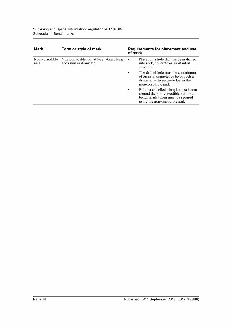
(2) The forms and styles of marks described in Schedules 1–4 (bench marks, boundarymarks, reference marks and permanent survey marks) are declared to be the formsand styles for survey marks under the Act.
(3) Survey marks must be placed and used in accordance with any requirementsspecified in Schedules 1–4.
28 Boundary marks
(1) A surveyor must mark definitely and durably by means of boundary marks:(a) all lines that form or are to form the boundaries between parcels, and(b) each corner of the land surveyed (including the corners of each parcel of land
in a subdivision).
(2) Boundary marks must be placed in such a manner that the boundaries are readily andunambiguously discernible on the ground.
(3) If it is not possible to place a boundary mark on a corner:(a) a reference mark must be placed and the surveyor must note on the survey plan
that the corner was not marked and why it was not marked, or(b) if the corner that cannot be marked is within the material of a structure that
does not have a surface accessible for marking, the corner may instead beshown by the obstructed boundary corner symbol depicted in Schedule 5 (inwhich case compliance with paragraph (a) is not required).
(4) If the mean high-water mark or bank at a corner of the land being surveyed is liableto erosion:(a) the boundary mark must be placed on the side boundary at a safe distance back
from the mean high-water mark or bank, and(b) the distance from that boundary mark to the mean high-water mark or bank
must be shown on the survey plan.
(5) In a rural survey, if a boundary is unfenced:(a) the lines that form it must also be marked with lockspits cut in the direction of
the boundary from each corner or angle or, if an obstacle exists at a corner orangle, with a suitable reference mark near that corner or angle, and
(b) the pegs and lockspits, or marks and lockspits, must be placed at intervals ofnot more than:(i) 200 metres, where 1 peg or mark cannot be seen from the next, or
(ii) 500 metres, where 1 peg or mark can be seen from the next, and(c) the survey plan must show the type and position of any line mark so placed,
and
Page 16 Published LW 1 September 2017 (2017 No 486)
Surveying and Spatial Information Regulation 2017 [NSW]Part 2 Survey practice
(d) unless it is unlawful to do so, or environmental considerations dictateotherwise:(i) the boundary must be reasonably cleared, and
(ii) any tree that has a trunk diameter greater than 100mm and is within500mm of the boundary must be blazed or, if situated on the boundary,double blazed.
(6) In a rural survey, if a fence post is on a corner at which a reference mark has beenplaced and reference is made to that post on the survey plan, no further marking ofthe corner is required.
(7) If drill holes, chisel marks or similar marks are to be placed for the purposes of thisclause in an ornamental wall, ornamental path or similar structure, the size of themark placed may be reduced to avoid undue damage to the wall, path or otherstructure being marked, but only if the marking is durable and readily andunambiguously discernible.
(8) This clause does not apply to a survey referred to in clause 18.
(9) In this clause, to blaze or double blaze a tree means to mark the tree with cuts in theapproved manner.
29 Marking of urban surveys
(1) This clause applies to urban surveys other than surveys referred to in clause 18.
(2) An urban survey of land that abuts a road must have reference marks:(a) at each extremity of the land surveyed, including the junction or intersection
of roads, and(b) at intervals of not more than 100 metres along a road frontage that has
intervening side boundaries.
(3) An urban survey of land that does not abut a road must have at least 2 reference marksat suitable locations in relation to the land surveyed.
(4) Subclause (2) (a) does not require the placement of a reference mark at any extremityof the land if some other reference mark is already placed within 10 metres of thatextremity and that reference mark is referenced to that extremity on the survey plan.
30 Marking of rural surveys
(1) This clause applies to rural surveys other than surveys referred to in clause 18.
(2) The surveyor must, in selected positions suitable for redefinition of the survey,connect, or place and connect, at least 2 reference marks for each parcel shown onthe survey plan.
(3) For a survey that affects only part of the land in a document of title, the surveyor mustconnect, or place and connect, at least 1 reference mark so as to refer to each terminalof each section surveyed.
(4) If a boundary (other than a road frontage) of the land exceeds 2,400 metres, whetheror not the boundary includes 1 or more bends, a surveyor must place additionalreference marks along the boundary at intervals of not more than 1,500 metres.
(5) If a boundary required to be marked is a road frontage, a surveyor must placereference marks in accordance with clause 31 (6).
(6) In addition, the surveyor must place reference marks so as to refer to:(a) if the land surveyed abuts a road, the extremity of the land surveyed, and(b) if the land surveyed is at a road intersection, the road intersection, and
Page 17 Published LW 1 September 2017 (2017 No 486)
Surveying and Spatial Information Regulation 2017 [NSW]Part 2 Survey practice
(c) if the land surveyed has frontage to a stream and the frontage is greater than500 metres, each stream bank and side boundary intersection.
(7) The surveyor must show on the survey plan connections across abutting roads wheresurvey marks are located that are relevant to the land being surveyed.
31 Roads to be marked with reference marks
(1) This clause applies to a survey made for the purpose of the creation, redefinition orwidening of a road under any Act.
(2) The surveyor must:(a) place reference marks in the positions prescribed by this clause, and(b) show the type and location of the reference marks in the survey plan.
(3) Those reference marks must be placed as follows in the case of an urban survey:(a) at the junction or intersection of roads:
(i) if a triangle is cut off from the corner formed by the intersection of theroad boundaries, so as to refer to either end of the base line of thetriangle or the point of intersection of the road boundaries, or
(ii) if the corner is rounded off, so as to refer to either tangent point or thepoint of intersection of the road boundaries, or
(iii) if the corner is not cut off or rounded off, so as to refer to the point ofintersection of the road boundaries, and
(b) so as to refer to the terminals of a road, and(c) as far as is practicable, so as to refer to the same side of the road, and(d) if placed in a road that is variable in width, with connections made to both
sides of the road, and(e) so as to refer to each angle of the road, and to each tangent point or terminal
of a series of chords of a regular curve in the road.
(4) Subclause (3) (e) does not require a reference mark to be placed within 30 metres ofanother reference mark.
(5) If a reference mark consists of a drill hole and wing, there must be 2 such marks.
(6) If the survey is a rural survey, reference marks must be placed in selected positions:(a) so as to refer to the terminals of the road surveyed and to each junction or
intersection of any other roads, and(b) in pairs suitable for orientation purposes throughout the whole length of the
road,so that the maximum distance between any 2 successive reference marks does notexceed 1,000 metres.
(7) If a road being created joins or intersects an existing road and reference marks havealready been placed in the existing road:(a) the existing marks must be connected to the new reference marks placed in the
road being created, and(b) the orientation of the existing reference marks must be compared with the
orientation of the new reference marks, and(c) the comparison between each series of reference marks must be shown on the
survey plan.
Page 18 Published LW 1 September 2017 (2017 No 486)
Surveying and Spatial Information Regulation 2017 [NSW]Part 2 Survey practice
32 Procedure on finding existing corner peg and reference mark
If a corner peg and reference mark are found together, a surveyor must determine thebearing and distance between them and, if a difference from the original reference isdisclosed, must decide from other evidence which of them to adopt and note detailsof the difference on the survey plan.
33 Procedure if monuments of original survey missing
To the extent that the relevant monuments of an original survey are missing, asurveyor must determine the boundaries and corners of the land surveyed bymeasurement in correct relation to:(a) adjoining or adjacent parcels of land, and(b) parcels of land on opposite sides of roads, and(c) fences, and(d) such other evidence of correct location as may be found after full investigation
and inquiry.
34 Procedure if differences exist between measured and recorded lengths
(1) If a measurement discloses the length of a boundary of land to be different from thatindicated in the document of title to the land, the surveyor:(a) must verify the length of the boundary, and(b) must make appropriate entries in the surveyor’s field notes, and(c) must show, in the notes and on any survey plan, the monuments or other
objects or points adopted for the purpose of verifying the length of theboundary.
(2) In the absence of monuments defining the land, the surveyor must indicate on thesurvey plan whether there is sufficient land available to permit the adoption of themeasurement referred to in subclause (1) without causing any encroachment on anyroad or any adjoining or adjacent parcel of land.
35 Surveyor to note nature and position of survey marks etc
(1) A surveyor must indicate on the survey plan:(a) the nature and position of any survey mark or monument found by the
surveyor, and(b) the nature of any survey mark (other than a peg) placed by the surveyor, and(c) the essential measurements from any reference mark, permanent survey mark
or monument to the applicable corner, angle, line mark or boundary.
(2) If reference marks are placed or found at depths of more than 150mm below theexisting surface of the ground, the surveyor must indicate the depths on the surveyplan.
(3) If reference marks are found, the surveyor must note their origin on the survey planby reference to the number of the plan on which the marks first occur.
(4) The state of a monument that is important for the definition of the land must beshown in the surveyor’s field notes, and on the survey plan, with the annotation“found”, “not found”, “gone”, “disturbed” or “inaccessible”, as appropriate.
(5) A monument must not be recorded as “gone” unless a thorough search for it has beenmade and the measurements of its probable site recorded in the surveyor’s fieldnotes.
Page 19 Published LW 1 September 2017 (2017 No 486)
Surveying and Spatial Information Regulation 2017 [NSW]Part 2 Survey practice
36 Placement of reference marks
A reference mark must be located in a position such that it is unlikely to be disturbed.
37 Use of broad arrows
A broad arrow may be used as a survey mark in relation only to a survey referred toin section 4 or 5 of the Act.
38 Deferment of placement of survey marks
(1) If it is likely that any work to be carried out on land will disturb any survey mark tobe placed on the land, a surveyor may defer the placement of the survey mark on thatland.
(2) In such a case, the surveyor:(a) must notify the Surveyor-General of the deferment, and(b) must deposit with the Surveyor-General the amount specified in Schedule 7 in
that regard, and(c) must comply with any requirement of the Surveyor-General.
(3) On completion of the work, the surveyor:(a) must place any deferred survey marks, and(b) must have their nature and position noted on the survey plan in the manner
approved by the Registrar-General, and(c) must inform the Surveyor-General that the survey has been completed in
accordance with any requirement referred to in subclause (2) (c).
(4) If the Surveyor-General is satisfied that the survey has been satisfactorily completed,the deposit must be returned to the surveyor less an administrative charge notexceeding 15 per cent of the amount deposited.
(5) A survey mark whose placement has been deferred under this clause must be placedwithin 28 days after completion of the relevant work.
39 Surveyor to report position of permanent survey marks
If, while carrying out a survey, a surveyor:(a) places a new permanent survey mark, or(b) becomes aware that an existing permanent survey mark has been removed,
damaged, destroyed, displaced, obliterated or defaced, or is in a state ofdisrepair,
the surveyor must notify the Surveyor-General of that fact and of the number andlocation of the permanent survey mark concerned.
Subdivision 2 Surveys to be lodged with Registrar-General or public authorities
40 Application
This Subdivision applies to any survey that is carried out for the purpose of lodginga survey plan with the Registrar-General or a public authority.
41 Surveys redefining or creating multiple parcels, roads or affecting interests
(1) A survey that redefines or creates parcels of land must be related to:(a) for a survey for 1–10 parcels—no fewer than 2 permanent survey marks, or(b) for a survey for 11–20 parcels—no fewer than 3 permanent survey marks, or
Page 20 Published LW 1 September 2017 (2017 No 486)
Surveying and Spatial Information Regulation 2017 [NSW]Part 2 Survey practice
(c) for a survey for more than 20 parcels—no fewer than 4 permanent surveymarks, plus an additional permanent survey mark for every 20 (or part of 20)by which the number of parcels exceeds 40.
(2) No more than 2 permanent survey marks existing at the time a survey referred to insubclause (1) is carried out may be used for the purposes of the survey concerned.
(3) A survey that redefines the frontage of a formed road or that is conducted for thepurposes of creating a road under any Act must be related to 2 or more permanentsurvey marks for each interval of 1,000 metres (for an urban survey) or 2,000 metres(for a rural survey).
(4) A survey for the purposes of creating an affecting interest that exceeds 200 metresmust have at least 2 permanent survey marks connected to the affected interest foreach interval of 2,000 metres (for an urban survey) or 4,000 metres (for a ruralsurvey).
(5) A survey for the purposes of creating an affecting interest that does not exceed200 metres must, if permanent survey marks are available within 300 metres of theaffecting interest, connect to 2 of those marks.
42 Connection to permanent survey marks
(1) The permanent survey marks to which a survey is required by clause 41 to be relatedmust each be connected by direct lines to separate corners of the land surveyed.
(2) The distance between any such corner and the permanent survey mark to which it isconnected must not exceed:(a) 500 metres, in the case of an urban survey, or(b) 1,000 metres, in the case of a rural survey.
(3) All permanent survey marks found or placed, and connections to the land surveyed,must be proved by closed survey and shown on the survey plan.
(4) However, subclause (3) does not apply to a permanent survey mark used for thepurpose of complying exclusively with clause 13.
43 New permanent survey marks
(1) A permanent survey mark placed for the purposes of a survey:(a) must be so located as to be suitable for orientation of the survey and for
redefinition of the survey, including orientation and redefinition by means ofGNSS surveying techniques, and
(b) must be located in a position such that it is unlikely to be disturbed, and(c) if situated at a road junction, road intersection, road angle or crest of a hill,
must be so located as to be:(i) visible from other permanent survey marks without obstruction, and
(ii) suitable for subsequent inclusion in the State control survey, and(d) must be identified in a sketch plan prepared in accordance with approved
standards.
(2) In the case of an urban survey, if any 2 of the permanent survey marks referred to inclauses 12 (2) and 41 (1) have accurate AHD values, an AHD value must be:(a) determined for any other permanent survey mark placed for the purposes of
the survey to an accuracy equal to or better than Class “B” or Class “LD”, and(b) verified by closed height difference between any 2 of the permanent survey
marks that have accurate AHD values.
Page 21 Published LW 1 September 2017 (2017 No 486)
Surveying and Spatial Information Regulation 2017 [NSW]Part 2 Survey practice
(3) A sketch plan referred to in subclause (1) (d):(a) must show the nature of each permanent survey mark placed by the surveyor,
and(b) must show the MGA co-ordinates of each such mark, together with an estimate
of the accuracy of those co-ordinates.
(4) The sketch plan must be forwarded to the Surveyor-General within 2 months of theplacement of the permanent survey mark concerned.
Division 5 Boundaries formed by tidal and non-tidal waters and other natural features
44 Definitions
In this Division:bed, in relation to a lake or stream, includes any portion of the lake or stream:(a) that is alternately covered and left bare with an increase or diminution in the
supply of water, and(b) that is adequate to contain the lake or stream at its average or mean stage
without reference to extraordinary freshets in time of flood or to extremedroughts.
lake includes any permanent or temporary lagoon or a similar collection of water notcontained in an artificial work, but does not include tidal waters.natural feature includes any cliff face or ridgeline, but does not include any tidal ornon-tidal waters.stream includes any non-tidal waters that are not a lake.
45 First survey of boundary of land adjoining Crown reserve or Crown road
(1) In any survey for the redefinition or subdivision of land adjoining an existing Crownreserve of stipulated width fronting tidal waters where the boundary between the landbeing surveyed and the Crown reserve has not previously been defined by survey, theboundary must be defined by straight lines approximately parallel to the position ofthe mean high-water mark as originally defined.
(2) In any survey for the redefinition or subdivision of land adjoining an existing Crownreserve or Crown road of stipulated width fronting a lake, stream or natural featurewhere the boundary between the land being surveyed and the Crown reserve orCrown road has not previously been defined by survey:(a) the boundary must be defined by straight lines approximately parallel to the
position of the bank of the lake or stream, or of the natural feature, as originallydefined, and
(b) the position of the bank or natural feature, as originally defined, must beshown on the survey plan, and
(c) the position of any existing road formation or fencing must be shown on thesurvey plan, and
(d) the boundary need not be marked in accordance with clause 28 but, if it is notmarked in accordance with that clause, a reference mark must be placed at theterminals of the boundary and at intervals of not more than 1,000 metres alongthe boundary.
(3) Approval to the definition of a boundary under subclause (1) or (2) must be obtainedfrom the Minister administering the Crown Lands Act 1989 or the Crown LandManagement Act 2016.
Page 22 Published LW 1 September 2017 (2017 No 486)
Surveying and Spatial Information Regulation 2017 [NSW]Part 2 Survey practice
(4) When seeking approval to the definition of a boundary, a surveyor must provide thatMinister with a comprehensive report regarding the surveyor’s determination of theboundary.
(5) The comprehensive report must include:(a) the basis and method of determining the position of the mean high-water mark,
bank or natural feature fronted by the Crown reserve or Crown roadconcerned, and
(b) the surveyor’s opinion as to the reason for any change in that position and theprocess by which the change has taken place, and
(c) such photographs, documents or other information relevant to the position ofthe mean high-water mark as is reasonably required by the person to whom thereport is to be provided.
(6) In this clause:Crown reserve:(a) has the same meaning as reserve has in Part 5 of the Crown Lands Act 1989, or(b) if that Act has been repealed, means Crown managed land within the meaning
of the Crown Land Management Act 2016.Crown road has the same meaning as it has in the Roads Act 1993.
46 First survey of mean-high water mark boundary or bank
(1) In any survey for the redefinition or subdivision of land adjoining an existingmean-high water mark boundary or bank that has not previously been defined bysurvey, the boundary or bank must be defined with sufficient accuracy to enable it tobe re-established in the future despite any natural changes that have occurred to it.
(2) Approval to the definition of a mean-high water mark boundary under this clausemust be obtained from the Minister administering the Crown Lands Act 1989 or theCrown Land Management Act 2016.
(3) When seeking approval to the definition of a mean-high water mark boundary, asurveyor must provide that Minister with a comprehensive report regarding thesurveyor’s determination of the boundary.
(4) The comprehensive report must include:(a) the basis and method of determining the position of the mean high-water mark,
and(b) such photographs, documents or other information relevant to the position of
the mean high-water mark as is reasonably required by the person to whom thereport is to be provided.
47 Surveys where boundary includes tidal or non-tidal waters or other natural feature
(1) A boundary formed by tidal waters, or by a lake, stream or natural feature, must besurveyed so that each change of course or direction of the boundary is determinedwith appropriate accuracy.
(2) If the actual position of the mean high-water mark of tidal waters, the bank of the lakeor stream or the natural feature is substantially different to the adopted position of theboundary, both the actual position and the position adopted under clause 48 or 49 areto be shown on the survey plan.
(3) If:(a) the middle line of a stream is the boundary of land and has not previously been
defined by survey, or
Page 23 Published LW 1 September 2017 (2017 No 486)
Surveying and Spatial Information Regulation 2017 [NSW]Part 2 Survey practice
(b) the middle line of a stream is otherwise required to be determined,both banks of the stream must be surveyed and shown on the survey plan togetherwith the determination of the middle line.
(4) The middle line of a stream need not be marked unless the purpose for which thesurvey is made so requires.
48 Changes in boundaries formed by tidal waters
(1) This clause applies to a survey if:(a) the mean high-water mark of tidal waters forms a boundary of the land to be
surveyed, and(b) since the date of a previous survey, there has been a change in the position of
the mean high-water mark of the tidal waters.
(2) If the change in the position of the mean high-water mark arose from natural, gradualand imperceptible accretion or erosion:(a) the position of the mean high-water mark as it is as the result of the change is
to be adopted unless paragraph (b) applies, or(b) in a case where section 55N (4) of the Coastal Protection Act 1979 applies to
the determination of the boundary concerned by reference to the meanhigh-water mark, the position of the mean high-water mark as it was before thechange is to be adopted.
Note. Section 55N (Modification of doctrine of erosion and accretion) of the Coastal ProtectionAct 1979 prevents certain determinations being made in relation to land that is within thecoastal zone, or that adjoins the tidal waters of Sydney Harbour or Botany Bay or theirtributaries, and that has a boundary that is defined or determined by reference to a meanhigh-water mark.
(3) If the change in the position of the mean high-water mark arose otherwise than fromnatural, gradual and imperceptible accretion or erosion, the position of the meanhigh-water mark, as defined by a survey plan, survey report or survey record filed orrecorded by the Registrar-General or a public authority before the change, is to beadopted.
(4) Approval to the adoption of a changed position referred to in subclause (2) (a) mustbe obtained from:(a) the Minister administering the Crown Lands Act 1989 or the Crown Land
Management Act 2016, if the adjoining land below the mean high-water markis Crown land, or
(b) the owner of the adjoining land, if the adjoining land below the meanhigh-water mark is not Crown land.
(5) When seeking approval under subclause (4), a surveyor must provide that Minister,or the owner of the adjoining land, as the case requires, with a comprehensive reportregarding the surveyor’s determination of the position of the mean high-water mark.
(6) The comprehensive report must include:(a) the basis and method of determining the position of the mean high-water mark,
and(b) the surveyor’s opinion as to the reason for any change in that position and the
process by which the change has taken place, and(c) such photographs, documents or other information relevant to the position of
the mean high-water mark as is reasonably required by the person to whom thereport is to be provided.
Page 24 Published LW 1 September 2017 (2017 No 486)
Surveying and Spatial Information Regulation 2017 [NSW]Part 2 Survey practice
49 Changes in boundaries formed by lakes, streams and natural features
(1) If, since the date of a previous survey, there has been a change in the position of thebank of a lake forming a boundary of land to be surveyed, then, in any subsequentsurvey, the position of the bank, as it was before the change, must be adopted.
(2) If, since the date of a previous survey, there has been a change in the position of thebank of a stream, or of some other natural feature, forming a boundary of land to besurveyed, then, in any subsequent survey:(a) for any change arising from natural, gradual and imperceptible accretion or
erosion, the position of the bank or natural feature, as it is as a result of thechange, must be adopted, or
(b) for any change arising otherwise than from natural, gradual and imperceptibleaccretion or erosion, the position of the bank or natural feature, as it was beforethe change, must be adopted.
50 Surveyor to report on certain determinations
(1) A surveyor who determines a new position for the bank of a stream, or for a naturalfeature, in connection with a survey carried out for the purpose of lodging a surveyplan with the Registrar-General or a public authority must lodge, together with thesurvey plan, a comprehensive report regarding the surveyor’s determination of thenew position.
(2) The comprehensive report must include:(a) the basis and method of determining the position of the bank or natural feature
concerned, and(b) the surveyor’s opinion as to the reason for any change in that position and the
process by which the change has taken place, and(c) such photographs, documents or other information relevant to the position of
the bank or natural feature as is reasonably required by the person to whom thereport is to be provided.
51 References to high-water mark and tidal waters in previous survey plans
For the purposes of preparing a survey, in any previous survey plan or otherdescription of land:(a) a reference to high-water mark is taken to be a reference to mean high-water
mark, and(b) a reference to, or description of, a boundary that abuts tidal waters is taken to
be a reference to, or description of, a boundary that abuts mean high-watermark, and
(c) a reference to a bank of a lake or stream is taken to be a reference to the limitof the bed of the lake or stream, and
(d) a reference to, or description of, a boundary that abuts a lake or stream is takento be a reference to, or a description of, a boundary that abuts the limit of thebed of the lake or stream,
unless a contrary intention appears.
Page 25 Published LW 1 September 2017 (2017 No 486)
Surveying and Spatial Information Regulation 2017 [NSW]Part 2 Survey practice
Division 6 Field notesNote. Other requirements with respect to the preparation of field notes are contained in various provisions inthe earlier Divisions of this Part.
52 Surveyor to make field notes
(1) A surveyor’s field notes must be neat, precise, complete and readily intelligible inaccordance with the usage of surveyors.
(2) Facts, readings and observations must be recorded immediately after they areascertained.
(3) A surveyor must keep an archive of:(a) all field notes made by the surveyor, with indices and cross-references set out
in a manner that facilitates the preparation of a complete and accurate surveyplan, and
(b) all other information and documentation relevant to those field notes.
(4) A surveyor’s field notes must include:(a) the nature and position of any survey mark or monument found by the
surveyor, and(b) the nature of any survey mark (other than a peg) placed by the surveyor.
53 Surveyor to retain electronic records
(1) If a survey has been recorded in whole or in part by electronic methods other thanGNSS methods:(a) an electronic copy (in the same form as the recording), and(b) a copy of the reduced and formatted data,must be retained in a manner that facilitates the preparation of a complete andaccurate survey plan.
(2) If a survey has been recorded in whole or in part by GNSS methods:(a) an electronic copy of all recorded data, and(b) a copy of the reduced baseline or positional results,must be retained in a form that facilitates the preparation of a complete and accuratesurvey plan.
54 Surveyor to record datum line in field notes
A surveyor must clearly indicate in the survey field notes the datum line of the surveyand the origin of the orientation adopted.
55 Surveyor to record landmarks in field notes
A surveyor must clearly indicate in the survey field notes the names of estates,houses, roads, rivers, creeks, lakes and the like, and house numbers, as far as they arematerial to the survey and ascertainable by the surveyor.
56 Surveyor to sign and date field notes
(1) In the case of a survey that has been performed by a surveyor personally or under thesurveyor’s supervision, the surveyor must personally sign and date each page orsheet of the field notes and (in the case of a survey recorded by electronic means)each page or sheet of the reduced and formatted data.
Page 26 Published LW 1 September 2017 (2017 No 486)
Surveying and Spatial Information Regulation 2017 [NSW]Part 2 Survey practice
(2) Before signing each page or sheet, the surveyor must be satisfied that the notes on itare accurate and that the date when the work recorded on it was performed appearson it.
57 Method of recording angles and bearings
All angles and bearings must be observed and recorded in degrees, minutes andseconds, and all bearings must be reckoned and expressed clockwise from zero to360 degrees.
Division 7 Survey plansNote. Other requirements with respect to the preparation of survey plans are contained in various provisionsin the earlier Divisions of this Part.
58 Medium and format of survey plans
A survey plan must be prepared in an approved medium and format.
59 Method of showing bearings and distances
(1) All angles and bearings must be shown on the survey plan in degrees, minutes andseconds, and all bearings must be reckoned and expressed clockwise from zero to360 degrees.
(2) All distances shown on the survey plan must be horizontal plane distances at groundlevel expressed in metres unless otherwise approved.
60 Survey plan to indicate name of locality, street address and type of survey
A survey plan must indicate:(a) the name assigned by the Geographical Names Board to the locality or suburb
within which the land concerned is situated, and(b) the name (if any) assigned by the local roads authority to any road shown on
the plan, and(c) where available, the street address or all of the street addresses of the land
concerned in the format required by the Surveyor-General’s Directions, and(d) whether the survey is an urban or rural survey, and(e) in a case where the plan includes a partially compiled lot, whether the terrain
is level/undulating or steep/mountainous.
61 Method of recording datum line
(1) The datum line adopted for a survey must be shown on the survey plan bydistinguishing characters placed at the terminals of the datum line and the nature ofthe marks defining the datum line must be noted on the plan.
(2) The horizontal datum adopted as orientation must be stated on the survey plan.
(3) The datum line and any verifying line must (if practicable) be related to the surveyby closed connection.
(4) If the orientation of the survey is adopted from a grid bearing derived from MGAco-ordinates of established survey marks, the survey plan must show a comparison,for the datum line and any verifying line, of measured bearings and distances (ifpracticable) with those calculated from the MGA co-ordinates.
(5) If the orientation of the survey is adopted from a grid bearing derived from MGAco-ordinates, determined using an approved GNSS method, of 2 permanent surveymarks or reference marks, the survey plan must show the grid bearing adopted anddistance between the 2 marks and GNSS validation referred to in clause 66.
Page 27 Published LW 1 September 2017 (2017 No 486)
Surveying and Spatial Information Regulation 2017 [NSW]Part 2 Survey practice
(6) If the orientation of the survey is adopted from a survey for which a plan is filed orrecorded by the Registrar-General or a public authority, the survey plan must show acomparison for the datum line of the measured bearing and distance (if practicable)with those calculated from or shown on the plan being adopted.
62 Use of reference marks
(1) A reference mark must not be referenced to more than 1 point on any survey plan.
(2) A reference mark must not be referenced to any point on a survey plan that is morethan 30 metres from that mark.
(3) Subclause (1) does not apply to a reference mark that is referenced to the extremityof the survey plan as referred to in clause 29 (3).
63 Method of showing boundaries generally
(1) A survey plan must:(a) show sufficient information to connect all survey marks (other than bench
marks) shown on the plan by bearing and distance, and(b) show the nature of the boundaries at the time of the survey, whether defined
by survey marks, lockspits, lines, fences, roads, natural or artificial features,buildings or walls, and
(c) show the width of all walls used in common and the position of the boundariesin those walls, and
(d) if a boundary is the face of a wall, describe the boundary as “face of wall”, and(e) show the description and location (including the age, nature, construction
material and relationship to the boundary) of any substantial structure(including any fence):(i) that is within 1 metre of the boundary of the land surveyed, or
(ii) that is otherwise relevant to the boundary definition, and(f) show the complete dimensions (including bearings and distances) of each
parcel of land surveyed, and(g) show the complete dimensions (including bearings and distances), if available,
of each partially compiled parcel of land included in the plan along with areference to the plan from which they were obtained, and
(h) record if the clearing and blazing of boundaries has not been undertaken inaccordance with clause 28 (5) (d).
(2) A wall must not be described as a “party wall” unless:(a) it is the subject of such easements as are referred to in relation to party walls
in the Conveyancing Act 1919, or(b) the survey plan is intended to create such easements in respect of the wall.
64 Method of showing natural feature boundaries
A survey plan that shows a natural feature boundary:(a) must describe the natural feature, and(b) must indicate the boundary by a spline curve that generally follows the
position of the boundary, and(c) must include a table of sequential bearings and distances that accurately locate
each change in direction of the natural feature, and(d) must show the connection between terminals of the natural feature for each lot.
Page 28 Published LW 1 September 2017 (2017 No 486)
Surveying and Spatial Information Regulation 2017 [NSW]Part 2 Survey practice
65 Surveys of land adjoining tidal waters
In the case of a survey of land adjoining tidal waters, a surveyor must show on thesurvey plan the description and relationship of any sea wall and reclaimed landadjacent to the mean high-water mark.
66 Survey plan to show GNSS validation
A survey plan that includes lines derived from GNSS observations:(a) must show, in an approved schedule on the survey plan, the details of the
GNSS validation in accordance with the Surveyor-General’s directions, and(b) if the orientation of the survey is adopted from a grid bearing derived from
MGA coordinates, determined using an approved GNSS method, of2 permanent survey marks or reference marks, the validation must beperformed and shown on the plan of survey for the datum line of orientation.
67 Conventional signs and symbols to be used on survey plans
In the preparation of any survey plan, the conventional signs and symbols set out inSchedule 5 must be used to indicate the matters to which they are referred by thatSchedule.
68 Surveyor to report on doubts, discrepancies and difficulties
(1) A surveyor must disclose any doubt, discrepancy or difficulty suggested by orencountered in a survey, either on the survey plan or in an accompanyingcomprehensive report.
(2) Without limiting subclause (1), a surveyor must disclose a discrepancy in excess of40mm + 200 parts per million.
69 Survey plan to show height difference schedule
(1) All height differences shown on the survey plan must be relative to the same datumand that datum must be shown in an approved schedule on the survey plan.
(2) In the conduct of a survey under either clause 13 or 43 (2), or both, the surveyor mustshow the following, for all permanent survey marks or bench marks referred to inthose clauses, in an approved schedule on the survey plan:(a) the measured height differences between pairs of marks as a closed sequence,(b) the identity of each mark comprising each pair referred to in subclause (a):
(i) in the case where the State control survey has assigned a mark type andnumber to the survey mark, as that mark type and number, or
(ii) in any other case, as an identification unique to that mark,(c) the survey method used to determine the height differences.
(3) All height differences must be determined by the surveyor to an accuracy equal to orbetter than Class “B” or Class “LD”.
70 Survey plan to show coordinate schedule
(1) All MGA co-ordinates shown on the survey plan must:(a) relate to the same MGA zone and that zone must be shown in an approved
schedule on the survey plan, and(b) be derived from the same datum and the datum adopted must be shown in an
approved schedule on the survey plan.
Page 29 Published LW 1 September 2017 (2017 No 486)
Surveying and Spatial Information Regulation 2017 [NSW]Part 2 Survey practice
(2) In relation to any survey mark used to define an accurate MGA orientation, or anypermanent survey mark, or any bench mark, found or placed, the surveyor must showthe following in an approved schedule on the survey plan:(a) the identity of the mark:
(i) in the case where the State control survey has assigned a mark type andnumber to the mark, as that mark type and number, or
(ii) in any other case, as an identification unique to that mark,(b) in the case of an established survey mark, the MGA co-ordinates of the mark
as recorded in SCIMS,(c) in the case of a mark that is not an established survey mark—the MGA
co-ordinates of the mark:(i) where the survey adopts an accurate MGA orientation:
(A) if the mark is not used for the purpose of complying exclusivelywith clause 13, as determined by the surveyor to a horizontalposition equal to or better than Class “D”, or
(B) if the mark is used for the purpose of complying exclusively withclause 13, as determined by the surveyor to a positionaluncertainty equal to or better than 3 metres, or
(ii) where the survey does not adopt an accurate MGA orientation, asdetermined by the surveyor to a positional uncertainty equal to or betterthan 3 metres,
(d) the accuracy of the MGA co-ordinates of the mark:(i) in the case of an established survey mark, as described in SCIMS, or
(ii) in the case of a mark that is not an established survey mark, asappropriate to the technique used to derive the co-ordinates,
(e) the survey method used to determine the MGA coordinates,(f) the state of the mark to be described as either “found”, “placed” or “disturbed”,(g) in the case of an established survey mark, the date on which the MGA
co-ordinates were obtained from SCIMS,(h) the combined scale factor in relation to the MGA co-ordinates.
71 Survey plan to show height schedule
(1) All height values shown on the survey plan must be relative to the same datum andthat datum must be shown in an approved schedule on the survey plan.
(2) In the conduct of a survey under either clause 13 or 43 (2), or both, the surveyor mustshow the following, for any permanent survey mark or bench mark referred to inthose clauses, in an approved schedule on the survey plan:(a) the identity of the mark:
(i) in the case where the State control survey has assigned a mark type andnumber to the survey mark, as that mark type and number, or
(ii) in any other case, as an identification unique to that mark,(b) the AHD value of the mark:
(i) in the case where the mark has an accurate AHD value, the valuerecorded in SCIMS, or
(ii) in the case where the mark does not have an accurate AHD value, asdetermined by the surveyor to an accuracy equal to or better thanClass “B” or Class “LD”,
Page 30 Published LW 1 September 2017 (2017 No 486)
Surveying and Spatial Information Regulation 2017 [NSW]Part 2 Survey practice
(c) the accuracy of the AHD value:(i) in the case where the mark has an accurate AHD value, the accuracy
described in SCIMS for the mark, or(ii) in the case where the mark does not have an accurate AHD value, as
appropriate to the method used to derive the AHD value,(d) in the case where the mark has an accurate AHD value, the height datum
validation to be described as either “SCIMS adopted” or “from SCIMS-datumvalidation”,Note. The single mark adopted to define the height datum for the survey is to bedescribed as “SCIMS adopted” and the mark or marks used to validate the heightdatum adopted are to be described as “from SCIMS-datum validation”.
(e) the state of the mark to be described as either “found”, “placed” or “disturbed”,(f) in the case where the mark has an accurate AHD value, the date on which the
AHD value was obtained from SCIMS.
72 Surveyor to furnish survey certificate
(1) A surveyor must endorse a survey certificate or provide a survey certificate with eachof the following plans provided by the surveyor:(a) a survey plan,(b) a compiled plan,(c) a plan relating to land that was partly surveyed and partly compiled.
(2) A survey certificate is to be in or to the effect of:(a) Form 1 in Schedule 6, for all plans other than those relating to surveys referred
to in clause 9, or(b) Form 2 in Schedule 6, for plans relating to surveys referred to in clause 9.
(3) Subject to clause 38, a survey certificate must not be issued until all survey marksrequired to be placed in connection with the plan the subject of the certificate havebeen duly placed.
(4) A survey certificate may be incorporated in any other certificate that must beendorsed or provided pursuant to any other Act or law.
Division 8 Public surveys
73 Standards for public surveys under section 4 or 5 of the Act
(1) Subject to the Surveyor-General’s directions, a survey referred to in section 4 or 5 ofthe Act must be carried out in accordance with the requirements set out in theStandards and Practices for Control Surveys.
(2) In any survey referred to in section 5 of the Act, all measuring equipment used in thesurvey must comply with the requirements of Division 3.
74 Field notes for surveys under section 5 of the Act
The field notes prepared in relation to a survey referred to in section 5 of the Act,including any electronic field data:(a) must be referenced and indexed in an approved manner, and(b) must be produced to the Surveyor-General on request.
Page 31 Published LW 1 September 2017 (2017 No 486)
Surveying and Spatial Information Regulation 2017 [NSW]Part 3 Administration
Part 3 Administration
Division 1 Constitution of Board
75 Constitution of Board
(1) The Institution of Surveyors New South Wales Incorporated is prescribed as theprofessional association of land surveyors to nominate persons for appointment tothe Board under section 27 (2) (c) of the Act.
(2) AIMS—Australian Institute of Mine Surveyors Limited is prescribed as theprofessional association of mining surveyors to nominate persons for appointment tothe Board under section 27 (2) (d) of the Act.
76 Committees to assist Board
(1) This clause applies to any committee established under section 30 of the Act.
(2) A committee must have at least 3 members.
(3) The convenor and deputy convenor of a committee are to be nominated by the Board,and may (but need not) be members of the Board.
(4) Committee meetings are to be held at the times and places determined by theconvenor of the committee.
(5) The procedures for convening committee meetings and for the conduct of businessat committee meetings are to be determined by the convenor of the committee.
(6) At a committee meeting, a majority of the committee members constitutes a quorum.
(7) The convenor of a committee (or, in the absence of the convenor, the deputyconvenor of the committee) is to preside at committee meetings.
(8) A decision supported by a majority of the votes cast at a committee meeting at whicha quorum is present constitutes a decision of the committee.
(9) In the event of an equality of votes, the convenor of the committee has a second, orcasting, vote.
(10) The convenor of a committee is to report all decisions of the committee to the nextBoard meeting.
Division 2 Formal Board determinations
77 Formal Board determinations
(1) The Board may, by resolution, make the following determinations:(a) a determination approving an examination for the purposes of the definition of
Board examination in clause 5 (1),(b) a determination approving a training agreement for the purposes of the
definition of recognised professional training agreement in clause 5 (1),(c) a determination recognising a qualification for the purposes of the definition
of recognised qualification in clause 5 (1),(d) a determination recognising abilities and experience (whether for a person or
a class of persons) for the purposes of the definition of surveyor’s assistant inclause 5 (1),
(e) a determination approving continuing professional development requirementsfor the purposes of clause 82,
Page 32 Published LW 1 September 2017 (2017 No 486)
Surveying and Spatial Information Regulation 2017 [NSW]Part 3 Administration
(f) a determination as to what constitutes general or immediate supervision for thepurposes of section 21 (3) of the Act.
(2) The Board is to ensure that copies of each of its determinations under this clause arepublished on its website and made available for inspection at each of its offices.
Division 3 Registration of surveyors
78 Application of Division
This Division applies to the registration of land surveyors and mining surveyors.
79 Qualifications for registration
A person is eligible to be registered as a surveyor if the person:(a) holds a recognised qualification, and(b) has recognised practical experience, and(c) has passed the Board’s examination or fulfilled the requirements of a
recognised professional training agreement, and(d) is, in the opinion of the Board, of good character.
80 Board examinations
Board examinations are to be conducted at such times and places as the Board maydetermine.
81 Provision of further information and supporting evidence
Without limiting section 43 (1) of the Licensing and Registration (UniformProcedures) Act 2002, the Board may require an applicant for registration as asurveyor to furnish the following documents:(a) documentary evidence that the applicant holds a recognised qualification,(b) documentary evidence that the applicant has recognised practical experience,(c) documentary evidence that the applicant has passed the relevant Board
examination or fulfilled the requirements of a recognised professional trainingagreement,
(d) one or more character references given in relation to the applicant within theprevious 2 years,
(e) a recent photograph of the applicant’s face that meets the specificationrequired for an Australian passport photograph by the Australian PassportOffice under the Migration Act 1958 of the Commonwealth.
82 Continuing professional development
(1) A registered surveyor must comply with the continuing professional developmentrequirements as set out in a formal Board determination.
(2) Compliance with the requirements of this clause is a condition of registration as asurveyor.
83 Conditions of registration as mining surveyor
Registration as a mining surveyor may be granted subject to a condition restrictingthe mining surveyor to the conduct of mining surveys in relation to open cut minesand underground metalliferous mines.
Page 33 Published LW 1 September 2017 (2017 No 486)
Surveying and Spatial Information Regulation 2017 [NSW]Part 3 Administration
84 Register of surveyors
(1) The following particulars are to be recorded in the register of surveyors, in relationto each registered surveyor, in addition to those required by section 49 (1) of theLicensing and Registration (Uniform Procedures) Act 2002:(a) the qualifications pursuant to which the surveyor was registered,(b) in the case of a surveyor who was originally registered or licensed interstate or
overseas, the State, Territory or country in which the surveyor was originallyregistered or licensed,
(c) the surveyor’s address for service of notices,(d) particulars of any action that the Board has taken in relation to the surveyor
under section 12 or 13 of the Act, together with the date on which the actionwas taken,
(e) in the case of a registered mining surveyor whose registration is subject to acondition restricting the mining surveyor to the conduct of mining surveys inrelation to open cut mines, a statement to that effect.
(2) The register of surveyors may be maintained in written or electronic form.
85 Certificates of meritorious service
The Board may issue a certificate of meritorious service to any person whosurrenders his or her certificate of registration, as referred to in section 50 (7) of theLicensing and Registration (Uniform Procedures) Act 2002, if satisfied that it isappropriate to do so in recognition of the person’s contribution to surveying in NewSouth Wales.
(1) Any person may lodge a complaint with the Board in relation to the conduct of asurveyor.
(2) Any such complaint is to be dealt with in accordance with the document entitledPolicy for the Consideration of Complaints Against Surveyors issued by the Boardand as in force from time to time.
Page 34 Published LW 1 September 2017 (2017 No 486)
Surveying and Spatial Information Regulation 2017 [NSW]Part 4 Miscellaneous
Part 4 Miscellaneous
87 Fees and deposits
The fees and deposits set out in Schedule 7 are payable in relation to the variousmatters referred to in that Schedule.
88 Notice of proposed entry to land under section 19 of the Act
(1) The notice referred to in section 19 (1) of the Act, whether for the conduct of a landsurvey or a mining survey, must be given in writing in the form set out in Form 3 inSchedule 6.
(2) The notice may be given:(a) by delivering it to any person who is apparently over the age of 16 years and
is apparently residing on, or in occupation of, the land to be entered, or(b) if there is no person available to give the notice as referred to in paragraph (a),
by affixing it in a conspicuous position:(i) at the main point of entry to the land, or
(ii) at the main point of entry to a building situated on the land, or(iii) to some other conspicuous object situated on the land.
89 Certificate of authority under section 26 of the Act
A certificate of authority referred to in section 26 of the Act, whether for a landsurveyor or a mining surveyor, must be issued by the Surveyor-General in the formof Form 4 in Schedule 6.
90 Applications to remove survey marks under section 24 of the Act
(1) An application for an authorisation referred to in section 24 (1) of the Act must bemade to the Surveyor-General at least 14 days before the date on which the applicantintends to remove, damage, destroy, obliterate or deface the survey mark in respectof which the authorisation is sought.
(2) This clause applies only to permanent survey marks, reference marks and benchmarks.
91 Exemption by Surveyor-General
(1) If the Surveyor-General is of the opinion that it is not practicable or necessary tocomply with a requirement of this Regulation in relation to a survey, theSurveyor-General may in writing exempt the surveyor conducting the survey fromcomplying with the requirement.
(2) An exemption may be granted with or without conditions. If a surveyor is exemptfrom a requirement subject to conditions, the exemption is ineffective unless all theconditions are met.
(3) A surveyor who obtains an exemption under this clause must record, on any surveyplan arising from the survey, the exemption number or type.
(4) If a survey plan is lodged with the Registrar-General or a public authority, thesurveyor who conducted the survey must furnish to that public authority, at the timeof lodgment of the survey plan, a copy of any exemption applying to the survey plan.
Page 35 Published LW 1 September 2017 (2017 No 486)
Surveying and Spatial Information Regulation 2017 [NSW]Part 4 Miscellaneous
92 Savings provision
(1) Any act, matter or thing that, immediately before the repeal of the Surveying andSpatial Information Regulation 2012, had effect under that Regulation continues tohave effect under this Regulation.
(2) Any requirement of this Regulation relating to the preparation of plans applies onlyto plans prepared after the commencement of this Regulation.
(3) The requirements of the Surveying and Spatial Information Regulation 2012 (as inforce before its repeal) continue to apply to the preparation of plans that werecommenced but not finished before that commencement.
Page 36 Published LW 1 September 2017 (2017 No 486)
Surveying and Spatial Information Regulation 2017 [NSW]Schedule 1 Bench marks
Schedule 1 Bench marks
(Clauses 5 (1) and 27)
Mark Form or style of mark Requirements for placement and use of mark
Permanent Survey Mark
As for the Permanent Survey Marks described in Schedule 4.
• As specified in Schedule 4.
Chiselled triangle
Chiselled equilateral triangle with sides at least 80mm long, 10mm wide and 10mm deep.
• Cut in a horizontal concrete, stone or substantial structure.
• The top surface of the concrete or stone within the triangle being the reference point.
Non-corrodible bolt or spike in concrete
A non-corrodible bolt or spike at least 65mm long.
• Bolt or spike inserted or fixed vertically into the sound concrete.
• The top of the bolt or spike being the reference point.
Non-corrodible nail or spike in tree
Non-corrodible nail or spike at least 65mm long.
• Horizontal notch in fixed timber or the sound wood at the base of a suitable tree.
• Nail or spike driven vertically into the sound wood of a suitable tree.
• The top of the nail or spike being the reference point.
Specific point A specific point on a permanent and substantial structure.
• The specific point must be adequately described.
• If practicable, a chiselled wing must be cut and directed to the mark.
Approved mark A mark of a durable character approved for specific terrain.
• As approved by the Surveyor-General.
“Bench Mark” token
A non-corrodible token at least 32mm in diameter and 1.5mm thick with “Bench Mark” permanently stamped, engraved or etched on the upper surface.
• Secured using a non-corrodible nail, spike, rivet or screw.
Page 37 Published LW 1 September 2017 (2017 No 486)
Surveying and Spatial Information Regulation 2017 [NSW]Schedule 1 Bench marks
Non-corrodible nail
Non-corrodible nail at least 50mm long and 6mm in diameter.
• Placed in a hole that has been drilled into rock, concrete or substantial structure.
• The drilled hole must be a minimum of 5mm in diameter or be of such a diameter as to securely fasten the non-corrodible nail.
• Either a chiselled triangle must be cut around the non-corrodible nail or a bench mark token must be secured using the non-corrodible nail.
Mark Form or style of mark Requirements for placement and use of mark
Page 38 Published LW 1 September 2017 (2017 No 486)
Surveying and Spatial Information Regulation 2017 [NSW]Schedule 2 Boundary marks
Schedule 2 Boundary marks
(Clauses 5 (1) and 27)
Mark Form or style of mark Requirements for placement and use of mark
Peg Peg of sound durable, hardwood or white cypress pine pointed for about two-thirds of its length or polycarbonate pegs as approved.Rural surveys—At least 450mm long and at least 75mm by 75mm nominal section at the top end.Urban surveys—At least 350mm long and at least 75mm by 35mm nominal section at the top end.
• The centre of the top of a peg must represent the survey point except that, if conditions prevent the correct centring of a peg, the survey point may be represented by a non-corrodible tack or nail driven into the peg.
• Peg must be placed upright in the ground, point downwards, so that its top is not more than 80mm above the ground level. The earth surrounding it must be securely compacted.
• If a peg projecting above the surface of the ground could be hazardous or inconvenient to the public the peg may, at the discretion of the surveyor, be placed flush with the surface of the ground. If that is done, the fact must be noted on the survey plan.
• When the depth of soil is insufficient to permit the conventional placement of a peg, then:(a) if there is sound rock, a drill
hole and wing or chiselled wings must be placed in the rock, or
(b) if there is no sound rock, a cairn of rocks must be built around the peg above the surface of the soil.
Drill hole Drill hole of at least 5mm in diameter and at least 10mm deep.
• Drilled into rock, concrete or substantial structure.
• If practicable, a chiselled wing must be cut and directed to the mark.
Non-corrodible nail (fixed timber)
Non-corrodible nail at least 65mm long. • Driven completely into fixed timber.
• If practicable, a chiselled wing must be cut and directed to the mark.
Metal spike or galvanised iron pipe
Metal spike at least 300mm long. If a solid metal spike, an external diameter of at least 20mm. If a pipe, an internal diameter of at least 20mm and a rim wall thickness of at least 3mm.
• Placed vertically and driven flush to the surface.
• Only to be used if the placement of a peg is not practicable.
Star picket Star picket at least 450mm long. • Placed vertically and at least flush with the surface of the ground.
Page 39 Published LW 1 September 2017 (2017 No 486)
Surveying and Spatial Information Regulation 2017 [NSW]Schedule 2 Boundary marks
“Boundary Mark” token
A non-corrodible token at least 32mm in diameter and 1.5mm thick with “Boundary Mark” permanently stamped, engraved or etched on the upper surface.
• Secured using a non-corrodible nail, spike, rivet or screw.
Non-corrodible nail
Non-corrodible nail at least 50mm long and 6mm in diameter.
• Placed in a hole that has been drilled into rock, concrete or substantial structure.
• The drilled hole must be a minimum of 5mm in diameter or be of such a diameter as to securely fasten the non-corrodible nail.
• Either a chiselled wing must be cut and directed to the mark or a boundary mark token must be secured using the non-corrodible nail.
Broad arrow Broad arrow comprising three chiselled wings at least 80mm long, 20mm wide and 10mm deep at the base, pointed at one end.
• Cut in rock, concrete, substantial structure or fixed timber.
Lockspit A trench, or line of packed stones, not less than 1 metre long, 200mm wide, 150mm deep and commencing 300mm from each boundary mark.
• Dug or placed in the direction of the boundary lines.
• If the type of soil renders trenches ineffective, direction stakes at least 50mm wide by 30mm thick by 450mm long may be placed in the direction of the boundary lines 4 metres distant from the corner.
Chiselled wing Chiselled wing at least 80mm long, 20mm wide and 10mm deep at the base, pointed at one end.
• Cut in rock, concrete, substantial structure or fixed timber.
• Not to be used by itself as a boundary mark.
Steel fence post A steel fence post (excluding a star picket).
• The steel fence post must be durable and installed in a permanent and stable base.
• The type of steel fence post and its relationship to the corner must be adequately described.
Approved mark A mark of a durable character approved for specific terrain.
• As approved by the Surveyor-General.
Mark Form or style of mark Requirements for placement and use of mark
Page 40 Published LW 1 September 2017 (2017 No 486)
Surveying and Spatial Information Regulation 2017 [NSW]Schedule 3 Reference marks
Schedule 3 Reference marks
(Clauses 5 (1) and 27)
Mark Form or style of mark Requirements for placement and use of mark
Permanent Survey Mark
As for the Permanent Survey Marks described in Schedule 4.
• As specified in Schedule 4.
Drill hole and wing
Drill hole at least 5mm in diameter and at least 10mm deep.
• Drilled into rock, concrete or substantial structure.
• A chiselled wing must be cut and directed to the mark.
Chiselled wing Chiselled wing at least 80mm long, 20mm wide and 10mm deep at the base, pointed at one end.
• Cut in a substantial structure, fixed timber or the sound wood of a suitable tree.
• The point of the chiselled wing being the reference point, the chiselled wing to face towards the relevant corner.
• Placed at a convenient height above ground level.
Broad arrow Broad arrow comprising 3 chiselled wings at least 80mm long, 20mm wide and 10mm deep at the base, pointed at one end.
• Cut in rock, concrete, substantial structure, fixed timber or the sound wood of a suitable tree.
• The point of the chiselled wing being the reference point.
• Faced towards the relevant corner.
• Placed at a convenient height above ground level.
Metal spike or galvanised iron pipe
Metal spike at least 300mm long, with an external diameter of at least 20mm. If a pipe, an internal diameter of at least 20mm and a rim wall thickness of at least 2.6mm.
• Placed vertically and at least 80mm below the surface of the ground, or deeper if placed below where fencing is likely to be erected.
Specific point A specific point on a permanent and substantial structure.
• The specific point must be adequately described.
• If practicable, a chiselled wing must be cut and directed to the mark.
• If the corner of the land surveyed abuts a road, an additional reference mark must be placed within the road corridor.
Galvanised star picket
Galvanised star picket at least 450mm long.
• Placed vertically and at least 80mm below the surface of the ground, or deeper if placed below where fencing is likely to be erected.
Non-corrodible nail
Non-corrodible nail at least 65mm long. • Driven completely into fixed timber.
• If practicable, a chiselled wing must be cut and directed to the mark.
Page 41 Published LW 1 September 2017 (2017 No 486)
Surveying and Spatial Information Regulation 2017 [NSW]Schedule 3 Reference marks
Non-corrodible nail and wing in tree
Non-corrodible nail at least 65mm long. • Driven into the sound wood of a suitable tree.
• The centre of the head of the nail being the reference point.
• Faced towards the relevant corner.
• Placed at a convenient height above ground level.
• A chiselled wing must be cut and directed to the nail.
PVC star picket PVC star picket at least 600mm in length made of material with a thickness of at least 3mm.
• For use in soil, swampy or marsh areas.
• Placed vertically and at least 80mm below the surface of the ground, or deeper if placed below where fencing is likely to be erected.
Reinforced concrete block
Reinforced concrete block in the form of a truncated pyramid 400mm long, 150mm square (at the lower end) and 100mm square (at the upper end) into the top of which a non-corrodible nail or plug at least 80mm long has been inserted at least 75mm deep.
• Placed vertically and at least 80mm below the surface of the ground, or deeper if placed below where fencing is likely to be erected.
“Reference Mark” token
A non-corrodible token at least 32mm in diameter and 1.5mm thick with “Reference Mark” permanently stamped, engraved or etched on the upper surface.
• Secured using a non corrodible nail, spike, rivet or screw.
Non-corrodible nail
Non-corrodible nail at least 50mm long and 6mm in diameter.
• Placed in a hole that has been drilled into rock, concrete or substantial structure.
• The drilled hole must be a minimum of 5mm in diameter or be of such a diameter as to securely fasten the non-corrodible nail.
• Either a chiselled wing must be cut and directed to the mark or a reference mark token must be secured using the non-corrodible nail.
Approved mark A mark of a durable character approved for specific terrain.
• As approved by the Surveyor-General.
Mark Form or style of mark Requirements for placement and use of mark
Page 42 Published LW 1 September 2017 (2017 No 486)
Surveying and Spatial Information Regulation 2017 [NSW]Schedule 4 Permanent survey marks
Schedule 4 Permanent survey marks
(Clauses 5 (1) and 27)
Type 1 (State Survey Mark)
Page 43 Published LW 1 September 2017 (2017 No 486)
Surveying and Spatial Information Regulation 2017 [NSW]Schedule 4 Permanent survey marks
Type 2 (State Survey Mark)
Fixation is by drilling and bonding with a suitable epoxy-resin compound
Page 44 Published LW 1 September 2017 (2017 No 486)
Surveying and Spatial Information Regulation 2017 [NSW]Schedule 4 Permanent survey marks
Type 4 (Urban Type)
Page 45 Published LW 1 September 2017 (2017 No 486)
Surveying and Spatial Information Regulation 2017 [NSW]Schedule 4 Permanent survey marks
Type 6 (Non Urban Type)
Page 46 Published LW 1 September 2017 (2017 No 486)
Surveying and Spatial Information Regulation 2017 [NSW]Schedule 4 Permanent survey marks
Type 7 (Feno Spike with Cover Box)
Page 47 Published LW 1 September 2017 (2017 No 486)
Surveying and Spatial Information Regulation 2017 [NSW]Schedule 4 Permanent survey marks
Type 8 (D.W.R. “C-Type” Mark)
Page 48 Published LW 1 September 2017 (2017 No 486)
Surveying and Spatial Information Regulation 2017 [NSW]Schedule 4 Permanent survey marks
Type 9 (Trigonometrical Station)
Page 49 Published LW 1 September 2017 (2017 No 486)
Surveying and Spatial Information Regulation 2017 [NSW]Schedule 4 Permanent survey marks
Type 10 (Rooftop Pillar)
Page 50 Published LW 1 September 2017 (2017 No 486)
Surveying and Spatial Information Regulation 2017 [NSW]Schedule 4 Permanent survey marks
Type 11 (Tier 2 CORS Pillar)
Page 51 Published LW 1 September 2017 (2017 No 486)
Surveying and Spatial Information Regulation 2017 [NSW]Schedule 4 Permanent survey marks
Type 12 (Tier 3 CORS Pillar—Freestanding)
Page 52 Published LW 1 September 2017 (2017 No 486)
Surveying and Spatial Information Regulation 2017 [NSW]Schedule 4 Permanent survey marks
Type 13 (Tier 3 CORS Pillar—Wall mounted, no eaves)
Page 53 Published LW 1 September 2017 (2017 No 486)
Surveying and Spatial Information Regulation 2017 [NSW]Schedule 4 Permanent survey marks
Type 14 (Tier 3 CORS Pillar—Wall mounted)
Page 54 Published LW 1 September 2017 (2017 No 486)
Surveying and Spatial Information Regulation 2017 [NSW]Schedule 4 Permanent survey marks
Type 15 (SSM Urban)
Page 55 Published LW 1 September 2017 (2017 No 486)
Surveying and Spatial Information Regulation 2017 [NSW]Schedule 4 Permanent survey marks
Type 16 (State Survey Mark)
Page 56 Published LW 1 September 2017 (2017 No 486)
Surveying and Spatial Information Regulation 2017 [NSW]Schedule 5 Conventional signs and symbols
Schedule 5 Conventional signs and symbols
(Clause 67)
Page 57 Published LW 1 September 2017 (2017 No 486)
Surveying and Spatial Information Regulation 2017 [NSW]Schedule 6 Forms
Schedule 6 Forms
(Clauses 72 (2), 88 (1) and 89)
Form 1 Survey certificate(Surveying and Spatial Information Regulation 2017—Clause 72)I, [insert name] of [insert address or firm name], a surveyor registered under the Surveying and SpatialInformation Act 2002, certify that:
*(a) the land shown in this plan was surveyed in accordance with the Surveying and Spatial InformationRegulation 2017, is accurate and the survey was completed on [insert date of completion of survey],or
*(b) the part of the land shown in this plan (*being/*excluding**…) was surveyed in accordance with theSurveying and Spatial Information Regulation 2017, the part surveyed is accurate and the survey wascompleted on [insert date of completion of survey] and the part not surveyed was compiled inaccordance with that Regulation, or
*(c) the land shown in this plan was compiled in accordance with the Surveying and Spatial InformationRegulation 2017.
Datum line:Type: *Urban/*RuralThe terrain is *Level-Undulating/*Steep-Mountainous
Signature:Dated:Surveyor Identification No:Surveyor registered underthe Surveying and Spatial Information Act 2002*Strike out inappropriate words.**Specify the land actually surveyed or specify any land shown in the plan that is not the subject of thesurvey.
Form 2 Certificate as to survey not requiring strict accuracy(Surveying and Spatial Information Regulation 2017—Clause 72)I, [insert name] of [insert address], a surveyor registered under the Surveying and Spatial Information Act2002, certify that the survey represented in this plan (or sketch) was made in accordance with clause 9 ofthe Surveying and Spatial Information Regulation 2017 and the survey was completed on [insert date ofcompletion of survey] and [is/is not]* a survey to be lodged with a public authority as referred to in thatclause.
Signature:Dated:Surveyor Identification No:Surveyor registered underthe Surveying and Spatial Information Act 2002* Strike out inappropriate words.
Form 3 Notice of entry(Surveying and Spatial Information Regulation 2017—Clause 88)To the occupier of: [insert reference to land proposed to be entered]I, [insert name] of [insert address], in my capacity as [insert capacity of person concerned, such as “asurveyor” or “an authorised person”], give notice under section 19 of the Surveying and SpatialInformation Act 2002 that I intend to enter the land referred to above on: [insert dates of proposed entry]together with my assistants for purposes relating to the making of a survey.
Page 58 Published LW 1 September 2017 (2017 No 486)
Surveying and Spatial Information Regulation 2017 [NSW]Schedule 6 Forms
Signature:Dated:Surveyor Identification No:Surveyor registered underthe Surveying and Spatial Information Act 2002
Form 4 Certificate of authority(Surveying and Spatial Information Regulation 2017—Clause 89)
Board of Surveying and Spatial Information
[photo]
I certify that:[name of person]Identification number:is [insert capacity of cardholder, such as “a surveyor” or “an authorised person”] and is authorised to exercise the powers of entry conferred by Part 4 of the Surveying and Spatial Information Act 2002
Date of issue[DD/MM/YY] Surveyor-General
Page 59 Published LW 1 September 2017 (2017 No 486)
Surveying and Spatial Information Regulation 2017 [NSW]Schedule 7 Fees and deposits
Schedule 7 Fees and deposits
(Clauses 38 and 87)
Item Matter for which fee or deposit payable Fee/deposit
1 Application to sit for Board examination $318 per subject
2 Application to enrol in recognised professional training agreement $74
3 Relodgment of application to enrol in recognised professional training agreement
$35
4 Variation of application to enrol in recognised professional training agreement
$35
5 Submission of recognised professional training agreement report $246
6 Resubmission of recognised professional training agreement report $122
7 Final interview (recognised professional training agreement report) $246
8 Application for granting of registration $74
9 Application for restoration of registration $405
10 Application for replacement of certificate of registration $74
11 Registration administration fee—registration in NSW only $461 or, in the case of registration as both a land surveyor and mining surveyor, $605
12 Registration administration fee—joint registration in NSW and the ACT
$605 or, in the case of registration as both a land surveyor and mining surveyor, $748