40
Sustainable Use of Groundwater in the Little Rock Creek Area A DNR Action Plan September 2018

Sustainable Use of Groundwater in the
Little Rock Creek Area
A DNR Action Plan
September 2018

500 Lafayette Road
St. Paul, MN 55155-4040
888-646-6367 or 651-296-6157
mndnr.gov
This information can be made available in alternative formats such as large print, braille or audio tape by
emailing [email protected] or by calling 651-296-6157.
©2018, State of Minnesota, Department of Natural Resources
Printed on recycled paper containing a minimum of 30 percent post-consumer waste and vegetable-based ink.
Sustainable Use of Groundwater in the Little Rock Creek Area: A DNR Action Plan 3
A Message from the Commissioner’s Office
The DNR is committed to working with local residents, businesses, and civic leaders to ensure that groundwater
use is sustainable in the Little Rock Creek Area. Together, we can make sure that groundwater supplies support
farming and other local businesses, domestic water supplies, recreational resources, and surface water systems.
Minnesota’s natural resources are a legacy that all Minnesotans hold in common, enriching our lives
economically, recreationally, and ecologically. Lakes, streams, and wetlands, along with the often invisible and
essential groundwater systems, are excellent examples of this tremendous inheritance.
The challenge to the present generation of Minnesotans is to use and manage our outstanding water legacy in
ways that create a sustainable quality of life. This requires not only economically efficient use of water today,
but also intentional conservation of the surface and groundwater systems that will support our communities, as
well as the natural and recreational resources we cherish, well into the future.
The people of the Little Rock Creek Area in Central Minnesota are meeting this challenge head on. Since January
of 2016, the DNR has been meeting with residents, irrigators, and local government leaders to discuss, analyze,
and plan for the sustainable use of groundwater in the area. This five-year groundwater management plan is a
direct result of those discussions. We deeply appreciate the time and energy these citizens have dedicated to
this effort.
From these planning discussions, it is clear that groundwater is a vital resource to individual farm operations,
and these businesses strongly support the local economy. Groundwater for domestic consumption is also critical
to families with private wells and cities with municipal supply systems. Wetlands in the Area support waterfowl
habitat. Little Rock Lake supports residential and recreational economies. Little Rock Creek is a designated trout
stream that flows through the heart of the Area.
It is also clear from our planning discussions that there are many perspectives on water management in the
Little Rock Creek Area. The DNR is committed to engaging with those diverse perspectives to ensure that
groundwater use remains sustainable in the Little Rock Creek Area. This plan identifies several near-term steps
we will take toward that end. These steps include additional data collection and analytical efforts to help us
explore current needs and potential future scenarios. We will work with local residents, businesses, and civic
leaders to identify the best way to manage the economically, recreationally, and ecologically important water
resources in the Area. We will work to sustain a high quality of life in the Little Rock Creek Area and provide to
future generations a natural resource inheritance worthy of Minnesota.
Tom Landwehr Commissioner, Minnesota Department of Natural Resources

Sustainable Use of Groundwater in the Little Rock Creek Area: A DNR Action Plan 4
Executive Summary
Minnesotans value their water resources. They expect the Minnesota Department of Natural Resources (DNR) to
support the sustainable use of groundwater by individuals, municipalities and business owners like those in the
Little Rock Creek Area. They also expect the DNR to protect and manage the state’s surface waters, including
cold water streams like Little Rock Creek. These expectations are expressed in Minnesota’s statutes and rules,
which the DNR uses to guide its management activities.
Currently available information suggests groundwater use in the Little Rock Creek Area may not be sustainable
because high volume use of groundwater is contributing to water quality impairments in Little Rock Creek and
its tributaries.
The DNR is certain that the lower portions of Little Rock Creek are directly connected to the groundwater
system. And that groundwater use is reducing the amount of groundwater reaching the creek. The potential for
negative impacts to surface waters is an issue. There are still important questions about the magnitude of the
impact that cumulative groundwater use is having on Little Rock Creek. Once we have defined the magnitude
more precisely, we can determine whether groundwater use is having a negative impact on the creek and, if so,
what actions might be needed to reduce the impacts to the creek.
Although water levels in area aquifers are affected by groundwater pumping, our analysis indicates that water
levels remain above threshold of concern for safe yield.
The DNR is developing this action plan for the following reasons:
• Groundwater use is vital to the people and economy of the Little Rock Creek Area.
• The DNR wants individuals, communities and businesses to keep using groundwater.
• The DNR can issue permits for groundwater use only if the use is sustainable as defined by
statute.
• The DNR is concerned that total permitted groundwater use in the area might not be
sustainable, because groundwater use might be having a negative impact on Little Rock
Creek.
• We know groundwater use is affecting the stream; we don’t know if it is causing a negative
impact.
We will be collecting and analyzing additional information to determine whether total permitted
groundwater use is or is not having a negative impact on Little Rock Creek.
We will continue to work with individuals, communities and businesses as we make this
determination and as we develop and implement this action plan.

Sustainable Use of Groundwater in the Little Rock Creek Area: A DNR Action Plan 5
The DNR recognizes the importance of groundwater to agricultural irrigators, livestock operators, small
businesses, municipalities and individuals in the Little Rock Creek Area. Opportunities to use groundwater will
become even more important as the area’s economy and population continue to develop and grow. The DNR
wants to provide current permit holders as much certainty as we can. So, barring unforeseen or extenuating
circumstances, such as well interferences the DNR will not change existing water appropriation permits through
December of 2022. In the same way, permits that are issued as “limited” will be extended through 2022.
We created an advisory team that included a variety of different perspectives to inform development of the
Draft DNR Action Plan. All advisory team meetings were open to the public so that additional perspectives could
also be heard.
We are very grateful for the time and energy the advisors, other stakeholders and the public gave to this
planning project. They are not responsible for the content of the plan, but their participation made it better.
Questions about this document or the project can be directed to Mark Hauck at 320-223-7846, or at
[email protected]. Visit the project web page at Little Rock Creek Area Project.
DNR Actions
The DNR will take the following actions over the next five years to ensure that groundwater use in the Little Rock
Creek Area is sustainable.
1. In order to keep the public aware of and involved in the management of groundwater in the Little Rock
Creek Area, the DNR will:
a. Develop a five-year action plan and work with the public to review the plan. The plan will guide
management actions from 2018 through 2022.
b. Keep individuals informed about the plan through the DNR website, email updates, and at least
one public meeting per year.
c. Initiate a second round of action planning in 2022.
2. In order to inform future decisions about a protected flow and a sustainable diversion limit for Little
Rock Creek, the DNR will do the following data collection and analysis before 2020:
a. Expand already existing stream flow and temperature monitoring and data collection on Little
Rock Creek.
b. Expand already existing groundwater level monitoring and data collection throughout the Little
Rock Creek Area.
c. Expand already existing fish habitat data collection and conduct new, detailed habitat analysis
(Physical Habitat Simulation Model). This includes a detailed analysis of stream flow, water
depth, type of stream beds and presence of aquatic vegetation.
d. Finalize groundwater flow analysis (a MODFLOW model), incorporating perspectives from a
technical advisory team. Publish a report on the analysis.
3. In order to determine if cumulative use is having a negative impact on Little Rock Creek, the DNR will
work with the public to:

Sustainable Use of Groundwater in the Little Rock Creek Area: A DNR Action Plan 6
a. Establish a protected flow for Little Rock Creek in 2020.
b. Based on the protected flow, establish a sustainable diversion limit for cumulative groundwater
appropriations in the Little Rock Creek Area in 2020.
c. Determine whether cumulative use is greater than the sustainable diversion limit in 2021.
4. In order to improve the hydrology and biology of Little Rock Creek, the DNR will evaluate the impact and
feasibility of a variety of management actions. The DNR will work with stakeholders to determine the
most appropriate management actions to keep permitted water use within the sustainable diversion
limit. The management actions to be evaluated include, but are not limited to:
a. Managing water levels differently in the Sartell Wildlife Management Area.
b. Pumping groundwater into Little Rock Creek and / or Bunker Hill Creek during times of low
stream flow (stream augmentation).
c. Enhancing water conservation by current water appropriation permit holders using methods
including the irrigation scheduling program offered by the Benton Soil and Water Conservation
District.
d. Increasing groundwater recharge while protecting water quality.
e. Developing a new water distribution system to supply irrigation water from wells that are
farther away from the creek.
f. Installing vegetated riparian buffers to improve temperature, sediment, and other water quality
aspects of the creek.
g. Modifying existing water appropriation permits to evaluate the impact not only on water quality
and fish habitat but also on the regional economy.
5. In order to more accurately estimate the amount of water being used in the Little Rock Creek Area, the
DNR will:
a. Work with water appropriation permit holders to evaluate the accuracy of their reported water
use estimates. This will start with a group of irrigators who volunteered to compare their own
existing water use estimates to flow meter measurements.
b. Clarify the number of livestock operations in the Little Rock Creek Area and their annual
groundwater use.
c. Clarify the extent of non-permitted groundwater uses in the Little Rock Creek Area, including
low-volume domestic wells and any high-volume users operating without permits.
6. In order to improve water quality in the Little Rock Creek area, the DNR will provide data and technical
support to:
a. Minnesota Department of Health and Minnesota Department of Agriculture to keep
contaminants in drinking water below health risk limits.
b. Minnesota Pollution Control Agency and local Soil and Water Conservation Districts to reduce
water quality impairments in Little Rock Creek.
7. In order to support the continued permitting of water use in the Little Rock Creek Area over the next
four years, the DNR will (barring extenuating circumstances, for example well interferences):

Sustainable Use of Groundwater in the Little Rock Creek Area: A DNR Action Plan 7
a. Issue only time-limited water use permits for new permits or permit amendments in the Little
Rock Creek Area. This will assure compliance with Minnesota rule and statute1. Time-limited
permits are effective through December 2022.
b. Extend existing limited water use permits through December 2022 to allow for continued water
use while data gathering and analysis are completed.
c. Approve water use permit transfers if there are no changes in volume and legal requirements
are met.
1 Minn. R. part 6115.0670, subp. 3, C., 3. and Minn. Stat. § 103G.287 and Minn. Stat. § 103G.285

Sustainable Use of Groundwater in the Little Rock Creek Area: A DNR Action Plan 8
Contents
Sustainable Use of Groundwater in the Little Rock Creek Area ................................................................................1
A Message from the Commissioner’s Office ..........................................................................................................3
Executive Summary ................................................................................................................................................4
How to use and review this document ...............................................................................................................5
DNR Actions ............................................................................................................................................................5
Introduction ............................................................................................................................................................9
The Place and the People .................................................................................................................................... 11
Groundwater is Important .................................................................................................................................. 14
Drinking water ................................................................................................................................................. 14
Irrigation .......................................................................................................................................................... 14
Livestock .......................................................................................................................................................... 14
Water Use at a Glance ..................................................................................................................................... 15
Natural Resources in the Area ............................................................................................................................. 16
The DNR’s Mission and Statutory Mandates ....................................................................................................... 17
Recent Management Challenges ......................................................................................................................... 18
Recent Permit Activity ..................................................................................................................................... 18
Cumulative Use ................................................................................................................................................ 19
Limited Permits ................................................................................................................................................ 20
Water Quality .................................................................................................................................................. 20
Response to the Challenges: Action Planning with Stakeholders ................................................................... 21
Impacts to Little Rock Creek ................................................................................................................................ 23
The Five-Year Action Plan .................................................................................................................................... 25
Appendices .......................................................................................................................................................... 29
Appendix A. Definitions ................................................................................................................................... 29
Appendix B. Project Advisory Team’s Input .................................................................................................... 33
Appendix C. Excerpt: “Minnesota DNR Thresholds Report” ........................................................................... 35
Appendix D. Important Statutes and Rules Governing DNR Water Management Actions ............................. 40

Sustainable Use of Groundwater in the Little Rock Creek Area: A DNR Action Plan 9
Introduction
The Little Rock Creek Area is one of several locations across Minnesota where groundwater use has been
increasing over the last several decades2. Groundwater use in the Little Rock Creek Area contributes significantly
to the local economy by providing water for cropland irrigation, livestock, businesses, and households.
Minnesotans want groundwater to support economic development and vibrant communities. They expect water
use to be sustainable. The DNR uses Minnesota statues and rules to help define sustainable use.
2 Freshwater Society. 2013. Minnesota’s Groundwater: Is our use sustainable? Freshwater Society special report. (Link)
Univ. of Minn. Water Resources Center. 2011. Minnesota Water Sustainability Framework. (Link)
Univ. of Minn. Water Resources Center. 2011. Agricultural Water Use Technical Work Team Report. Minnesota Water Sustainability Framework. (Link)
Minnesota Environmental Quality Board. 2010. Minnesota Water Plan. (Link)
Minnesota Department of Natural Resources. 2013. Draft Strategic Plan for the DNR Groundwater Management Programs (Link)
The DNR is developing this action plan for the following reasons:
• Groundwater use is vital to the people and economy of the Little Rock Creek Area.
• The DNR wants individuals, communities and businesses to keep using groundwater.
• The DNR can issue permits for groundwater use only if the use is sustainable as defined by
statute.
• The DNR is concerned that total permitted groundwater use in the area might not be
sustainable, because groundwater use might be having a negative impact on Little Rock
Creek.
• We know groundwater use is affecting the stream; we don’t know if it is causing a negative
impact.
We will be collecting and analyzing additional information to determine whether total permitted
groundwater use is or is not having a negative impact on Little Rock Creek.
We will continue to work with individuals, communities and businesses as we make this
determination and as we develop and implement this action plan.

Sustainable Use of Groundwater in the Little Rock Creek Area: A DNR Action Plan 10
In November 2015, the DNR initiated a project to develop a five-year action plan to ensure that the increasing
groundwater use in the Little Rock Creek Area remains sustainable. The DNR is focusing on the Little Rock Creek
Area for a number of reasons:
groundwater use has been increasing rapidly,
water use is high compared to the flow of water into and through the watershed,
Little Rock Creek is at risk of being negatively impacted by high levels of groundwater use, and
the Minnesota Pollution Control Agency identified groundwater use as a contributing factor to water
quality problems in Little Rock Creek.
This five-year action plan outlines the data gathering and analysis that the DNR must do to ensure groundwater
use in the Little Rock Creek Area remains sustainable. The DNR has designated three groundwater management
areas in other parts of the state: the Straight River near Park Rapids, the Bonanza Valley around Belgrade, and
the north and east portion of the Twin Cities metropolitan area3. These groundwater management areas have
served as a reference for the Little Rock Creek Area project.
The DNR organized a group of stakeholders to provide perspectives and advice on local groundwater
management issues. The team included water appropriation permit holders, local officials, and state water
regulatory staff. More than half of the team members held water appropriation permits. The Project Advisory
Team met thirteen times between January 2016 and July 2017. The meetings were open to the public, with
fifteen to twenty audience members joining. Input was gathered through small groups, surveys, individual
meetings and phone interviews.
The advisory team meetings provided an opportunity to discuss technical and regulatory questions, understand
information from irrigators and other water users, receive updates from agencies and organizations, and voice
opinions about groundwater issues.
The DNR sincerely appreciates the time and energy members of the Project Advisory Team and other
stakeholders have given this project. Their perspectives and advice helped us think harder and more creatively
about groundwater in the Little Rock Creek Area and have directly shaped this plan. Contributions from the
Project Advisory Team are highlighted in Appendix B.
3 Minnesota Department of Natural Resources. 2016. Bonanza Valley Groundwater Management Area Plan (Link)
Minnesota Department of Natural Resources. 2017. Straight River Groundwater Management Area Plan (Link)
Minnesota Department of Natural Resources. 2015. North and East Metro Groundwater Management Area (Link)

Sustainable Use of Groundwater in the Little Rock Creek Area: A DNR Action Plan 11
The Place and the People
The Little Rock Creek Area was delineated by the DNR to help manage the sustainable use of groundwater. The
Area includes groundwater users who are all using the same groundwater system.
The Little Rock Creek Area is in northwestern Benton and southern Morrison Counties. It is bounded to the
North by the Skunk River, to the west by the Platte River, to the east by the watershed boundary of Little Rock
Creek and to the south by Little Rock Lake.
Figure 1. A map of the Little Rock Creek Area

Sustainable Use of Groundwater in the Little Rock Creek Area: A DNR Action Plan 12
The Little Rock Creek Area is home to approximately 5,650 residents; with 1,650 living in the countryside and
about 4,000 residing in the cities of Royalton, Buckman and Rice4. The most common jobs in the Royalton and
Rice areas are in health care, professional services, trade, manufacturing, construction, leisure and hospitality,
and crop and animal production. For Benton and Morrison counties, the highest economic outputs by industry
were in manufacturing, professional and business services, agriculture and forestry5.
Land use in the Area is predominantly agricultural, with a history of both animal and row crop operations.
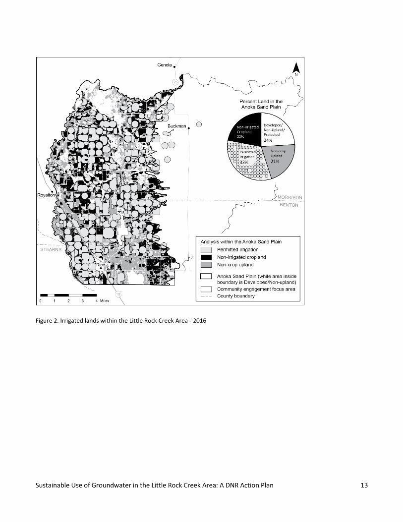
The Little Rock Creek Area is approximately 120,000 acres. A little over 61,000 acres are in the Anoka Sand Plain,
which is made up of sandy soils. The DNR’s 2015 analysis shows about 21,000 acres of the Little Rock Creek
portion of the Anoka Sand Plain area are irrigated. About 13,000 acres are dryland farm fields and about 13,000
acres are upland that is not cropland, wetland, protected land or developed land6 (figure 2).
4 US Census Bureau. 2010. (Link)
5 US Department of Labor, Bureau of Labor Statistics. 2015. (Link)
6 Analysis by Minnesota DNR with data provided by USDA National Agricultural Statistics Service. 2017. Cropland Data Layer. (Link)
Sustainable Use of Groundwater in the Little Rock Creek Area: A DNR Action Plan 13
Figure 2. Irrigated lands within the Little Rock Creek Area - 2016

Sustainable Use of Groundwater in the Little Rock Creek Area: A DNR Action Plan 14
Groundwater is Important
Drinking water
Groundwater provides almost all of the drinking water for the 5,650 residents of the Little Rock Creek Area.
Water supplied to homes for domestic use is the highest priority water use in Minnesota. Water management in
the Little Rock Creek Area reflects this priority.
Water from Little Rock Creek flows into the Mississippi River. The cities of St. Cloud, Minneapolis and St. Paul
draw water from the Mississippi River to provide drinking water to their residents.
State agencies coordinate activities on drinking water to reduce the risk of contamination and overuse and
protect human health.
Irrigation
Since 1969, individuals and businesses that use large quantities of groundwater have received permits from the
DNR. Over 95% of estimated water use in the Little Rock Creek Area is for cropland irrigation.
Irrigation significantly increases overall crop yields in the sandy soils of the Anoka Sand Plain. The combination of
sandy soils and irrigation make for excellent growing conditions7 for specialty crops such as potatoes, edible
beans and seed corn. Increased yields and these specialty crops allowed some growers to access new markets,
increase their property values and provide added value to their operations. In turn, cities, townships, counties
and schools have received increased tax revenues8.
As of August 2016, 179 water use permits were issued for crop irrigation. Ten of those permits were issued in
2016.
The installation of new irrigation systems accelerated after the drought of 1976 and then again from 2005 to
2015, when 71 new permits were issued. Some wells may have been installed prior to 2005, but were not
permitted until later.
Livestock
The Little Rock Creek Area is home to a variety of livestock operations that depend on groundwater. These
include broiler chickens, laying chickens, hogs, dairy cows, beef cows9 and turkeys.
7 United States Department of Agriculture Soil Survey. 1977. Hubbard loamy fine sand interpretation. Page 30. (Link)
8 Brian Koester. Benton County Assessor. 2017.
9 United States Department of Agriculture. 2012. Census of Agriculture – county data. (Link)

Sustainable Use of Groundwater in the Little Rock Creek Area: A DNR Action Plan 15
The DNR needs more information on livestock water use in the Little Rock Creek Area. A small portion (0.3%) of
permitted water use is for livestock operations. Much of the livestock water use in the Little Rock Creek Area
does not require a DNR permit and is not reported. There is likely some livestock-related water use in the Area
that does not have the required permits. Members of the Project Advisory Team report that the number of
livestock operations is steadily growing and the amount of water consumed by livestock in the Area may be
significantly higher than reported.
Water Use at a Glance
From 1988 to 2016, the annual reported groundwater use varied from a low of about 1 billion gallons in 1993 to
a high of about 5.4 billion gallons in 2013 (figure 5). Water use in the 10 year period between 2008 and 2017
shows, 96.24 % of the groundwater use was for agricultural irrigation, 2.54% was reported for municipal (city)
water supply and 0.2% was for livestock watering10. An estimated 1.02 % was pumped from private domestic
wells that do not typically require a water appropriation permit and 0.01% was for non-crop irrigation (figure 3).
10 Minnesota DNR. Minnesota Permit and Reporting System.
Figure 3. Water Use in Little Rock Creek Area

Sustainable Use of Groundwater in the Little Rock Creek Area: A DNR Action Plan 16
Natural Resources in the Area
Important natural resources in the Little Rock Creek Area include large wetland complexes, native prairie
remnants and two cold water streams. There are also forested areas, warm water streams and the northern
edge of Little Rock Lake. The fish and wildlife that use these habitats are important natural resources. The
groundwater resources are vital to all who reside in the Little Rock Creek Area.
Little Rock Creek and its tributary, Bunker Hill Creek are cold water streams that receive water from aquifers in
the Area. They are home to fish and wildlife that thrive in cold water streams with a baseflow of groundwater.
Cold water streams are uncommon in this part of the state.
Little Rock Creek and Bunker Hill Creek are state-designated trout streams. The DNR manages Little Rock Creek
as a recreational trout fishery. It was originally stocked in 1908. Yearly stocking occurred from 1962 to 1972.
Stocking resumed in 1995. Currently, the DNR stocks trout every year alternating between brown trout and
brook trout. Trout population assessments, fish community assessments, and stream temperature monitoring
are conducted by the DNR. The DNR has worked with landowners to obtain access easements that provide the
public with fishing recreation opportunities in Little Rock Creek and Bunker Hill Creek.
As a part of this plan, the DNR will measure and model the variety of fish habitats in Little Rock Creek. This
information will help us better understand the stream’s ecosystems and its potential as a cold water resource in
Central Minnesota.
Figure 4. Little Rock Creek

Sustainable Use of Groundwater in the Little Rock Creek Area: A DNR Action Plan 17
The Minnesota Pollution Control Agency has listed Little Rock Creek as an impaired water11. The agency
identified three types of water quality impairments, including a lack of healthy community of cold water sport or
commercial fish and associated aquatic life, low oxygen levels in the water, and high nitrate levels in the water.
This plan identifies several actions that the DNR is taking to help address these impairments.
Outdoor recreation is important. Camping is available at Benton Beach on the north end of Little Rock Lake.
Hunting occurs on both private land and at the nine Wildlife Management Areas found in the Little Rock Creek
Area. Recreational fishing is enjoyed on the Mississippi River, Little Rock Lake, Little Rock Creek and Bunker Hill
Creek.
The DNR’s Mission and Statutory Mandates
State law directs the DNR to conserve, manage, and develop water resources in Minnesota12. Water resources
include both surface water and groundwater. Laws and rules pertaining to water use and permitting can be
found in Appendix C.
The DNR’s mission is to work together with citizens to conserve and manage the state’s diverse natural
resources, to provide outdoor recreation opportunities, and to provide for commercial uses of natural resources
in a way that creates and maintains a sustainable quality of life.
Specific state statutes require the DNR to ensure that Minnesota’s groundwater and surface water resources are
being used sustainably13. Minn. Stat. § 103G.287, subdivision 5 states, “The commissioner may issue water-use
permits for appropriation from groundwater only if the commissioner determines that the groundwater use is
sustainable to supply the needs of future generations and the proposed use will not harm ecosystems, degrade
water, or reduce water levels beyond the reach of public water supply and private domestic wells constructed
according to Minnesota Rules, chapter 4725.”
High volume users (over 10,000 gallons a day or 1 million gallons a year) must have a water appropriation permit
from the DNR14. Permit holders in the Little Rock Creek Area include municipalities, agricultural irrigators,
livestock operations and a few other businesses. Individuals using less than 10,000 gallons a day or less than 1
million gallons a year, which is typical of private domestic wells, do not need a DNR water appropriation permit.
New wells must obtain a separate well construction permit from the Minnesota Department of Health.
The DNR has identified the following as important management objectives of sustainable groundwater use:
11 Minnesota Pollution Control Agency. 2015. Little Rock Creek Watershed Total Maximum Daily Load Report: Dissolved Oxygen, Nitrate, Temperature and Fish Bioassessment Impairments. (Link) 12 Minn. Stat. § 103G.255. (Link)
13 Minn. Stat. § 103G.287, subd. 5 (Link)
14 Minn. Stat. § 103G.271, subd. 1 (Link)
Sustainable Use of Groundwater in the Little Rock Creek Area: A DNR Action Plan 18
1. High volume use of groundwater must be reasonable, efficient, and comply with water conservation
requirements;
2. High volume use of groundwater must not harm ecosystems, aquifers, or create negative impacts to
surface waters;
3. All high volume groundwater users must have the necessary permits to use the water legally;
4. High volume use of groundwater must not degrade water quality; and
5. High volume use of groundwater must not create unresolvable well interferences or water use conflicts.
These management objectives were first described in the DNR’s 2013 Strategic Plan for the Groundwater
Management Program. The DNR considers permitted water use in a given area to be sustainable when all five
management objectives are met.
In the Little Rock Creek Area, the DNR is concerned that Management Objective 2 (High volume use of
groundwater must not harm ecosystems, aquifers, or create negative impacts to surface waters) is not being
met because cumulative water use may be having a negative impact on Little Rock Creek and its ecosystems.
DNR is also concerned that Management Objective 4 (High volume use of groundwater must not degrade water
quality) is not being met because the Minnesota Pollution Control Agency’s 2015 Total Maximum Daily Load
(TMDL) report identified lower groundwater levels as a contributing factor to the water quality impairments in
Little Rock Creek.
This action plan highlights steps the DNR will take to determine if groundwater use is having a negative impact
on Little Rock Creek.
Recent Management Challenges
Recent Permit Activity
The number of wells drilled in the Little Rock Creek Area has risen over time as seen on Figure 5. The number of
water appropriation permits issued in any particular year fluctuates. Most recently within the Little Rock Creek
Area:
In 2014, the DNR issued 18 new water use permits for agricultural irrigation. These permits were
evaluated for possible negative impacts to Little Rock Creek. Some permit applications were for
irrigation systems that were already pumping groundwater, but had not previously obtained a permit.
In 2015, the DNR issued seven water appropriation permits for agricultural irrigation.
In 2016, the DNR issued 10 water use permits in the Area; eight were for agricultural crop irrigation, one
for livestock watering and one for athletic field irrigation.
In 2017, the DNR issued one water use permit for agricultural irrigation and one for livestock watering.

Sustainable Use of Groundwater in the Little Rock Creek Area: A DNR Action Plan 19
Cumulative Use
Reviewing the large number of new permit applications in 2014, the DNR became concerned that unpermitted
appropriations might have a direct and significant impact on Little Rock Creek. The significant impact of primary
concern is the potential reduction in the flow of groundwater to the stream, which is known as stream
depletion. Stream flow reduction happens naturally in times of drought. The concern is the possibility that
cumulative groundwater use may create increased frequency and severity of drought-like low flows.
The basis for that concern was:
Aquifer level measurements taken during aquifer tests of individual wells linked groundwater pumping
to stream depletion.
The DNR calculated stream depletion using standard analysis of requested pumping volumes for several
permit applications.
The DNR’s statewide watershed health assessments showed that water appropriation in the Little Rock
Creek Area was high in comparison to the amount of stream flow.
Minnesota Pollution Control Agency’s groundwater flow analysis showed stream flow depletion in Little
Rock Creek resulting from cumulative groundwater use across the area.
Figure 5 Reported Water Use in the Little Rock Creek Area
Sustainable Use of Groundwater in the Little Rock Creek Area: A DNR Action Plan 20
The DNR recognized that cumulative water use by both new and established permitted users might also
be having a negative impact on the stream.
The DNR conducted a groundwater flow analysis to improve the understanding of cumulative groundwater use
and Little Rock Creek stream flow. This analysis will be used to identify if there are negative impacts to Little
Rock Creek from groundwater use and, if so, what actions would be effective in eliminating them.
The DNR will produce a groundwater flow analysis report in 2018.
Limited Permits
Individuals and organizations are applying for high volume water appropriation permits in the Little Rock Creek
Area. During the duration of this plan, new permits will be issued as time limited permits.15.
Water Quality
Streams
The Minnesota Pollution Control Agency identified three water quality impairments in Little Rock Creek:
high nitrate levels,
low dissolved oxygen levels, and
lack of a cold water assemblage (healthy community of cold water sport or commercial fish and
associated aquatic life).
A section of Bunker Hill Creek, a tributary to Little Rock Creek, is impaired by high nitrate levels.
The Minnesota Pollution Control Agency’s 2015 Total Maximum Daily Load (TMDL) report identified lower
groundwater levels as a contributing factor to the water quality impairments in Little Rock Creek and Bunker Hill
Creek. The report recommends a combination of doubling the groundwater flow into the river system and
removing the man-made impoundment at the Sartell Wildlife Management Area to meet the dissolved oxygen
standard and temperature criteria, while an increase in groundwater flow would be necessary to meet the
drinking water standard for nitrate in Little Rock Creek.
Groundwater
The aquifers in the Little Rock Creek Area have varying concentrations of nitrate contamination. Several
domestic wells have nitrate levels above the health risk limit established by the Department of Health.
15 DNR Water Appropriation Permits can be changed or modified at any time. However, “Limited” permits include a specific date for permit review and possible action.

Sustainable Use of Groundwater in the Little Rock Creek Area: A DNR Action Plan 21
The Minnesota Department of Agriculture tested drinking water wells for nitrates between 2013 and 2016 in
targeted townships across the state, including in the Little Rock Creek Area. Four townships in the Area were
tested. In two townships, more than 10% of the tested wells exceeded the health risk limit of 10 parts per million
(ppm). The percentage of wells exceeding the health risk limit for nitrates were:
47.3% of the 109 private wells tested in Agram Township (Morrison County) 16
15% of the 101 private wells tested in Langola Township (Benton County)17
Maximum nitrate levels have steadily increased in municipal wells in the City of Rice. Levels were recently at 7
ppm, approaching the health risk limit of 10 ppm. The City of Rice is one of 62 Minnesota community water
suppliers with nitrate levels between 3 and 10 ppm who are working with the Minnesota Department of Health
to reduce nitrate contamination in their wells. Agricultural producers in the Rice wellhead protection area are
partners in this effort.
The water quality issues in the Area are of concern to the DNR. The DNR is relying on the efforts of other
agencies, specifically the Department of Health, Department of Agriculture, and the Pollution Control Agency to
deal directly with water quality issues. The DNR will uphold its responsibilities to ensure that groundwater use
remains sustainable.
Response to the Challenges
Action Planning with Stakeholders
The DNR initiated a project to develop a five-year action plan to address the challenges summarized above and
ensure that it was doing what was necessary to keep groundwater use sustainable in the Area. The DNR
established a Project Advisory Team, including irrigators, local government leaders, and interested citizens. The
team met monthly, starting in January of 2016. This five-year action plan is the result of that effort.
The Project Advisory Team met 13 times over 18 months. The diverse perspectives of the team members have
shaped the DNR’s response and improved this plan. Examples of input from the team are in Appendix B. In
addition to team meetings, DNR leadership met with several advisors individually to better understand their
particular concerns and advice.
The DNR is committed to science-based natural resource management and is undertaking additional data
collection and analysis necessary to determine if cumulative use of groundwater is having a negative impact on
Little Rock Creek.
16 Minnesota Department of Agriculture. 2016. Morrison County: Final Overview of Nitrate Levels in Private Wells (2013 – 2016) (Link)
17 Minnesota Department of Agriculture. 2016. Benton County: Final Overview of Nitrate Levels in Private Wells (2013 – 2016) (Link)

Sustainable Use of Groundwater in the Little Rock Creek Area: A DNR Action Plan 22
Over the next three years, the DNR is committed to exploring and evaluating a range of possible solutions to the
water management challenges in the Little Rock Creek Area. The solutions identified for further consideration
include, but are not limited to:
Managing water levels differently in the Sartell Wildlife Management Area.
Pumping groundwater into Little Rock Creek and / or Bunker Hill Creek during times of low stream flow
(stream augmentation).
Enhancing water conservation by current water appropriation permit holders.
Increasing groundwater recharge.
Developing a new water distribution system to supply irrigation water from wells that are farther away
from the stream.
Installing vegetated riparian buffers to improve temperature, sediment, and other water quality aspects
of the stream.
Modifying existing water appropriation permits (evaluate the impact not only on water quality and fish
habitat but also on the regional economy).
Working with stakeholders and members of the public is a cornerstone of the DNR’s approach to problem
solving and management. We will continue to work with groundwater users in the Little Rock Creek Area as we
collect and analyze data, evaluate management options, and decide on a course of action.
Measurement and Analysis
The DNR will assure reliable Little Rock Creek Area analysis by using reliable data sources and most appropriate
analysis methods. Two important analytical tools are the groundwater flow model (MODFLOW) and the physical
habitat simulation model (PHABSIM).
The DNR has gathered natural resources data in the Little Rock Creek Area for decades. Water appropriation
permit holders are required to report annual water use. Reporting began in 1969 in the Little Rock Creek Area.
Little Rock Creek fisheries data was first gathered in 1908. The DNR has conducted 18 Little Rock Creek fish
population surveys since 1982. Little Rock Creek stream temperature has been measured since the mid-1990s.
As of May 2018, the DNR Division of Ecological and Water Resources managed a statewide cooperative network
of over 1030 groundwater-level groundwater level monitoring wells. The DNR maintains 20 observation wells in
the Little Rock Creek Area. The earliest Benton County observation well water level data collection began in
1975. The earliest Morrison County observation well water level data collection began in 1989. The majority of
the DNR observation wells in the Little Rock Creek Area have been replaced or refurbished beginning in 2014. All
of the DNR observation wells in the Area are now instrumented to collect continuous groundwater levels.
The DNR maintains three stream gage locations in the Little Rock Creek Area that continuously record stream
stage, temperature and flow data. The Minnesota Pollution Control Agency maintains a fourth stream gage
location to collect field measurements. The earliest continuous stream flow monitoring began in 1998 and the
most recent permanent stream gaging stations were installed in 2017.

Sustainable Use of Groundwater in the Little Rock Creek Area: A DNR Action Plan 23
The Benton SWCD has installed a dissolved Oxygen sensor at the DNR’s long term stream gage.
Impacts to Little Rock Creek
The lower portions of Little Rock Creek are connected to the groundwater system. The stream flow is made up
of groundwater that seeps into the streambank and runoff from rainfall and snowmelt. Groundwater
appropriations can end up diverting groundwater from entering the stream. We are trying to determine how
much groundwater can be diverted away from the stream before it affects the water flow and biology of the
stream.
Little Rock Creek is a cold water stream that supports plant and animal communities adapted to streams with
lower water temperatures and higher dissolved oxygen levels. The DNR has a history of stocking the stream with
trout to maintain a recreational fishery. The creek receives year-round supplies of cool groundwater from the
water table aquifer (the shallowest aquifer).
Most water in streams comes from both runoff and from groundwater. Sustained flow of a stream in the
absence of direct runoff is known as “baseflow”. Baseflow is essential to maintain the cold water conditions in
the stream, particularly in the hot, dry month of August. Animals and plants that are adapted to these conditions
are especially sensitive to reductions in baseflow. Too much groundwater pumping can reduce baseflow and
change the biology of the stream. This is what we are trying to avoid.
Stream scientists have developed a framework for understanding how stream flow, and baseflow in systems like
Little Rock Creek, interacts with biological communities to create the unique ecology of each stream system. The
DNR’s January 2016 report, Definitions and Thresholds for Negative Impacts to Surface Waters, explores the
influence of stream flow and water levels on biological communities in Minnesota’s rivers, streams, lakes, and
wetlands18.
According to Minnesota Rules, a stream’s “protected flow” is the amount of water required in the watercourse
to meet the needs of fish and wildlife habitat, water quality and priority downstream users19.
A part of the stream flow in Little Rock Creek comes from groundwater that seeps into the creek through the
stream bed. Groundwater pumping can divert water to the pumping well that would have otherwise flowed to
the stream bed and into the creek. The sustainable diversion limit is the maximum amount of water that can be
removed directly or indirectly, through diversion, from a surface water body in a defined geographic area on an
annual basis without causing a negative impact to the surface water body.
18 Minnesota DNR. 2016. Report to the Minnesota State Legislature: Definitions and Thresholds for Negative Impacts to Surface Waters (Link)
19 Minn. R. part 6115.0630, subp. 12. (Link)

Sustainable Use of Groundwater in the Little Rock Creek Area: A DNR Action Plan 24
Key considerations for Little Rock Creek stream systems include:
1. Little Rock Creek varies in the water it carries throughout the year, ranging from higher flows in the
spring and early summer to lower flows at the end of summer and through early autumn.
2. The lower flows of August are important “biological windows” because fish and other animals must
survive the hot dry weather with comparatively little water in the stream.
3. Higher demand for groundwater for agricultural irrigation and lawn watering tends to coincide with
Little Rock Creek’s “biological window”, so there is additional lowering of the water table aquifer during
August low flows.
Research on stream systems around the country indicate that if more than 20% of baseflow during low flow
conditions is diverted, then the biological communities in those streams will change and some species may be
lost from the stream. For more information on this topic, see Appendix C.

Sustainable Use of Groundwater in the Little Rock Creek Area: A DNR Action Plan 25
The Five-Year Action Plan
Below are actions the DNR will take over the next five years to ensure that groundwater use in the Little Rock
Creek Area is sustainable.
Action Description
20
18
20
19
20
20
20
21
20
22
1. In order to keep the public aware of and involved in the management of groundwater in the
Little Rock Creek Area, the DNR will:
a. Develop a five-year action plan and work with the public to review the plan. The plan will guide management actions from 2018 through 2022.
X
b. Keep individuals informed about the plan through the DNR website, email updates, and at least two public meetings per year.
X X X X X
c. Initiate a second round of action planning in 2022. X
2. In order to inform future decisions about a protected flow and a sustainable diversion limit
for Little Rock Creek, the DNR will do the following data collection and analysis before 2020:
a. Expand already existing stream flow and temperature monitoring and data collection on Little Rock Creek.
X X
b. Expand already existing groundwater level monitoring and data
collection throughout the Little Rock Creek Area.
X X
c. Expand already existing fish habitat data collection and conduct new, detailed habitat analysis (Physical Habitat Simulation Model). This includes a detailed analysis of stream flow, water depth, type of stream beds and presence of aquatic vegetation.
X X

Sustainable Use of Groundwater in the Little Rock Creek Area: A DNR Action Plan 26
Action Description
20
18
20
19
20
20
20
21
20
22
d. Finalize groundwater flow analysis (a MODFLOW model) incorporating perspectives from a technical advisory team. Publish a report on the analysis.
X
3. In order to determine if cumulative use is having a negative impact on Little Rock Creek, the
DNR will work with the public to:
a. Establish a protected flow for Little Rock Creek in 2020. X
b. Based on the protected flow, establish a sustainable diversion limit for cumulative groundwater appropriations in the Little Rock Creek Area in 2020.
X
c. Determine whether cumulative use is greater than the sustainable
diversion limit in 2021.
X
4.
In order to improve the hydrology and biology of Little Rock Creek, the DNR will evaluate
the impact and feasibility of a variety of management actions. The DNR will work with
stakeholders to determine the most appropriate management actions to keep permitted
water use within the sustainable diversion limit. The management actions to be evaluated
include, but are not limited to:
a. Managing water levels differently in the Sartell Wildlife Management
Area.
X X
b. Pumping groundwater into Little Rock Creek and / or Bunker Hill Creek during times of low stream flow (stream augmentation).
X X
c. Enhancing water conservation by current water appropriation permit
holders using methods including the irrigation scheduling program
offered by the Benton Soil and Water Conservation District.
X X

Sustainable Use of Groundwater in the Little Rock Creek Area: A DNR Action Plan 27
Action Description
20
18
20
19
20
20
20
21
20
22
d. Increasing groundwater recharge while protecting water quality. X X
e. Developing a new water distribution system to supply irrigation water from wells that are farther away from the stream.
X X
f. Installing vegetated riparian buffers to improve temperature, sediment, and other water quality aspects of the creek.
X X
g. Modifying existing water appropriation permits to evaluate the impact not only on water quality and fish habitat but also on the regional economy.
X
5. In order to more accurately estimate the amount of water being used in the Little Rock
Creek Area, the DNR will:
a. Work with water appropriation permit holders to evaluate the
accuracy of their reported water use estimates. This will start with a
group of irrigators who volunteered to compare their own existing
water use estimates to flow meter measurements.
X X
b. Clarify the number of livestock operations in the Little Rock Creek
Area and their annual groundwater use.
X X X
c. Clarify the extent of non-permitted groundwater uses in the Little
Rock Creek Area, including low-volume domestic wells and any high-
volume users operating without permits.
X X X
6. In order to improve water quality in the Little Rock Creek area, the DNR will provide data
and technical support to:

Sustainable Use of Groundwater in the Little Rock Creek Area: A DNR Action Plan 28
Action Description
20
18
20
19
20
20
20
21
20
22
a. Minnesota Department of Health and Minnesota Department of
Agriculture to keep contaminants in drinking water below health risk
limits.
X X X X X
b. Minnesota Pollution Control Agency and local Soil and Water Conservation Districts to reduce water quality impairments in Little Rock Creek.
X X X X X
7. In order to support the continued permitting of water use in the Little Rock Creek Area over
the next four years, the DNR will (barring extenuating circumstances such as well
interferences):
a. Issue only time-limited water use permits for new permits or permit
amendments in the Little Rock Creek Area. This will assure
compliance with Minnesota rule and statute. Time-limited permits
are effective through December 2022.
X X X X X
b. Extend existing limited water use permits through December 2022 to allow for continued water use while data gathering and analysis are completed.
X X X X X
c. Approve water use permit transfers if there are no changes in volume and legal requirements are met.
X X X X X

Sustainable Use of Groundwater in the Little Rock Creek Area: A DNR Action Plan 29
Appendices
Appendix A. Definitions
Baseflow – Sustained flow of a stream in the absence of direct runoff. It includes natural and human-induced
stream flows. Natural base flow is sustained largely by groundwater discharges20.
Cumulative use – Water use from multiple wells over a geographic area.
Delineate – to mark the outline of, or to indicate or represent by drawn or painted lines.
Ecosystem harm – In relation to water appropriations, to change the biological community and ecology in a
manner that results in a less desirable and degraded condition22.
Fish bioassessment – Measuring the number and variety of fish species in water bodies.
Hydrogeologic – The area of geology that deals with the distribution and movement of groundwater in the soil
and rocks of the Earth's crust21.
Impaired waters – Under federal law, section 303(d) of the Clean Water Act, states, territories and authorized
tribes, collectively referred to in the act as "states," are required to develop lists of impaired waters. These are
waters for which technology-based regulations and other required controls are not stringent enough to meet
the water quality standards set by states. The law requires that states establish priority rankings for waters on
the lists and develop Total Maximum Daily Loads (TMDLs) for these waters. A TMDL includes a calculation of the
maximum amount of a pollutant that can be present in a waterbody and still meet water quality standards22.
Little Rock Creek Area – A geographic area established by the Minnesota DNR where the effects of groundwater
pumping are assessed for their cumulative impacts to Little Rock Creek.
Median August stream flow – The middle flow measurement in a given sequence of flow measurements over
some period of data collection during the month of August, including precipitation, runoff and groundwater
inputs. Half of the flow measurements for this location would be higher than the median flow and half of the
measurements would be lower than the median flow.
Median August baseflow – The middle flow measurement in a given sequence of flow measurements over some
period of data collection during the month of August, typically including only groundwater inputs. Half of the
20 USGS Water Science School definitions. Website (Link).
21 Wikipedia. Website (Link).
22 US EPA, Program Overview: Impaired waters and TMDLs. (Link)

Sustainable Use of Groundwater in the Little Rock Creek Area: A DNR Action Plan 30
flow measurements for this location would be higher than the median flow and half of the measurements would
be lower than the median flow.
Negative impact – In relation to water appropriations, a change in hydrology sufficient to cause ecosystem harm
or alter riparian uses long-term23.
Permitted water use – Water use that is authorized (permitted) by the State of Minnesota. A permit is required
for all water use in excess of 10,000 gallons per day or 1 million gallons per year.
Protected flow – The amount of water required in the watercourse to accommodate instream needs such as
water-based recreation, navigation, aesthetics, fish and wildlife habitat, water quality, and needs by
downstream higher priority users located in reasonable proximity to the site of appropriation24
Riparian buffers – An area consisting of perennial vegetation, excluding invasive plants and noxious weeds,
adjacent to [all] bodies of water within the state and that protects the water resources of the state from runoff
pollution; stabilizes soils, shores, and banks; and protects or provides riparian corridors. Minnesota's buffer law
requires perennial vegetation buffers of up to 50 feet along public waters and public ditches25.
Stream augmentation – Increasing stream flow by conveying water to the stream from alternative sources or
locations.
Stream depletion – When a well removes water from an aquifer, the hydraulic system must be rebalanced by
induced recharge to the aquifer, or a decrease in groundwater discharge (Theis, 1940; Bredehoeft and others,
1982). If the imbalance is made up by induced recharge from a stream or by a decrease in groundwater
discharge to a stream, the well has caused stream depletion (Jenkins, 1968)26.
Stream flow – The water discharge that occurs in a natural channel27.
Sustainable diversion limit – In relation to water appropriations, a maximum amount of water that can be
removed directly or indirectly from a surface water body in a defined geographic area on an annual basis
without causing a negative impact to the surface water body23.
Sustainable groundwater use –Permitted water use is sustainable when the following five management
objectives are met:
23 Minnesota DNR Report to the Minnesota State Legislature: Definitions and Thresholds for Negative Impacts to Surface Waters. (Link).
24 Minn. R., part 6115.0630 subp. 12
25 Minn. Stat. 103F.48 Subd. 1, (c)
26 Montana Bureau of Mines and Geology (page 1, introduction). Website (Link).
27 USGS. Water Science Glossary of Terms. Website (link).

Sustainable Use of Groundwater in the Little Rock Creek Area: A DNR Action Plan 31
1. High volume use of groundwater must be reasonable, efficient, and comply with water conservation
requirements;
2. High volume use of groundwater must not harm ecosystems, aquifers, or create negative impacts to
surface waters;
3. All high volume groundwater users must have the necessary permits to use the water legally;
4. High volume use of groundwater must not degrade water quality; and
5. High volume use of groundwater must not create unresolvable well interferences or water use conflicts.
Time limited water appropriation permit – In the context of the LRCA, the DNR has issued permits with a
specific time limitation because the DNR is completing specific analysis to determine sustainable use. The DNR
will continue to issue permits for new applications only as time limited permits until the analysis is complete.
Water allocation priorities –Minn. Stat. § 103G.261 establishes the following water allocation priorities for the
consumptive appropriation and use of water:
1. “first priority, domestic water supply, excluding industrial and commercial uses of municipal water
supply, and use for power production that meets contingency planning provisions of section 103G.285,
subdivision 6;
2. second priority, a use of water that involves consumption of less than 10,000 gallons of water per day;
3. third priority, agricultural irrigation, and processing of agricultural products involving consumption in
excess of 10,000 gallons per day;
4. fourth priority, power production in excess of the use provided for in the contingency plan developed
under section 103G.285, subdivision 6;
5. fifth priority, uses, other than agricultural irrigation, processing of agricultural products, and power
production, involving consumption in excess of 10,000 gallons per day; and
6. sixth priority, nonessential uses.”
Water appropriation permit (water use permit) – Permission from the DNR Commissioner for the use of waters
of the state in excess of 10,000 gallons per day or 1 million gallons per year. The permit may specify water
pumping rates, water use volumes, water conservation measures and other conditions. “The commissioner may
issue water-use permits for appropriation from groundwater only if the commissioner determines that the
groundwater use is sustainable to supply the needs of future generations and the proposed use will not harm
ecosystems, degrade water, or reduce water levels beyond the reach of public water supply and private domestic
wells constructed according to Minnesota Rules, chapter 4725.” Minn. Stat. § 103G.287, subd. 5.
Water appropriation permit program – System of implementing water use statutes and rules that exists to
balance competing management objectives that include both development and protection of Minnesota's water
resources28.
28 Minnesota DNR Water Appropriations Permit Program. Website. (Link)

Sustainable Use of Groundwater in the Little Rock Creek Area: A DNR Action Plan 32
Water table – The top of the water surface in the saturated part of an aquifer.
Water use conflict – Occurs where the available supply of water in a given area exceeds the competing demands
for that water by users having the same water use priority.
Well interference – When a public water supply or domestic well owner loses access to water because a high-
volume water appropriation is taking place nearby and water levels recede below the pump of the affected
well29.
29 Minnesota DNR Well Interference Fact Sheet. Website. (Link)

Sustainable Use of Groundwater in the Little Rock Creek Area: A DNR Action Plan 33
Appendix B. Project Advisory Team’s Input
The Project Advisory Team and the public had opportunities to offer suggestions, opinions or positions at
meetings over a year and a half period. Input was received through small groups, surveys, individual meetings
and phone interviews. Project Advisory Team involvement and input from the public was important to the DNR
and has contributed significantly to this draft plan.
Project Advisor Team Input: When you write the plan, be clear about the problem and what DNR intends to do
about it.
Created this change: The DNR created a plan that is concise, describes the problem and focuses on
actions.
Project Advisory Team Input: The DNR models are only as good as the information that goes into them and we
have concerns about the evapotranspiration values that the DNR used.
Created this change: The DNR has committed to additional data collection and analysis before
considering changes to permits. The DNR re-evaluated and modified the evapotranspiration values used
in the model, has consulted with Department of Agriculture experts on evapotranspiration values for
crops, will review findings with statewide experts, and will validate groundwater flow analysis with a
third party.
Project Advisory Team Input: If depleting stream flow only happens in August, pumping more water in the
stream for that month might maintain habitat without reducing permitted use.
Created this change: The DNR will evaluate the feasibility of stream augmentation to mitigate August
stream depletion.
Project Advisory Team Input: There is a lack of science and plenty of speculation on the DNR’s part.
Created this change: In the Little Rock Creek Area, the DNR will conduct a new study of how stream
habitat is affected by groundwater pumping for use in permit decisions. This will be added to
groundwater flow, stream flow, aquifer testing and other analyses already completed in the Little Rock
Creek Area.
Project Advisory Team Input: The DNR is trying to put irrigators out of business.
Created these changes: 1. The DNR has committed to conduct substantial additional data collection and analysis to ensure that
sound science is applied to our management of groundwater in the Little Rock Creek Area. 2. The DNR will not modify permitted volumes for existing water appropriation until first evaluating
other water management strategies such as water conservation. 3. The DNR will extend permits issued for a limited time period to allow continued groundwater use
while the additional data collection, analysis and alternatives evaluation are being completed.

Sustainable Use of Groundwater in the Little Rock Creek Area: A DNR Action Plan 34
Project Advisory Team Input: The DNR claims that water use reporting by irrigators may not be accurate, without
offering proof.
Created this change: Irrigators volunteered to work with the DNR to determine accuracy of water use
reporting by calibrating pumps for irrigation systems.
Project Advisory Team Input: Evapotranspiration is higher on native vegetation than in irrigated row crops.
Created this change: The DNR further studied evapotranspiration research, including information
submitted to the DNR by the Project Advisory Team. Evapotranspiration values used for the
groundwater flow model were re-evaluated.
Project Advisory Team Input: The DNR and the Minnesota Pollution Control Agency blame irrigators for warmer
water in Little Rock Creek. The water impoundment at the Sartell Wildlife Management Area is very likely
causing Little Rock Creek to warm up, so the DNR should take action.
Created this change: The DNR will monitor and analyze stream flows in and around the Sartell Wildlife
Management Area and will incorporate this information in future management decisions.
Project Advisory Team Input: The rules on permit transfers are confusing.
Created this change: The DNR developed a document that clarified permit transfers for permit holders
and landowners.

Sustainable Use of Groundwater in the Little Rock Creek Area: A DNR Action Plan 35
Appendix C. Excerpt: “Minnesota DNR Thresholds Report”
Excerpted from Minnesota DNR’s Report to the Minnesota State Legislature: Definitions and Thresholds for
Negative Impacts to Surface Waters. January 2016.
Executive Summary
Background and purpose
This report was prepared in response to Laws 2015, chapter 4, article 4, which directed the Department of
Natural Resources (DNR) to consult with interested stakeholders and develop recommendations for statutory or
rule definitions and thresholds for negative impacts to surface waters.
The DNR is charged with managing water resources to assure an adequate and sustainable supply for multiple
uses. Minnesota has a modified riparian water law system, in which landowners have the right to make
reasonable use of the abutting surface waters or the groundwater beneath their land, as defined and regulated
by the water appropriation permitting program. The water itself is a public trust resource, and the state grants
the right to water beyond personal use – above 10,000 gallons per day or one million gallons per year – through
water appropriation permits. In recent years, it has become increasingly clear that Minnesota’s water resources,
while abundant in many areas, are not unlimited. In some areas, increasing water withdrawals are using more
groundwater than is naturally being recharged. In other areas, groundwater supplies are limited due to the
underlying geology.
Groundwater contamination is also a limiting factor in many areas.
The variability of Minnesota’s climate and geography mean that rainfall is not always available in the quantities
we need at the times when it is most needed. Increasing demands on both surface water and groundwater
supplies can cause negative impacts to the ecosystems and riparian uses of streams, lakes, and wetlands. While
water levels fluctuate naturally throughout the year and across multiple years, water appropriations can push
low levels lower, significantly reducing stream flows and more frequently putting fish, wildlife, plant
communities and riparian uses at risk.
This report examines the effects of groundwater use on rivers and streams, lakes, and wetlands. The DNR’s
analysis and recommendations are based on the fact that surface water bodies go through seasonal and multi-
year cycles of high and low water levels. The seasonal patterns, known as the seasonal hydrograph, are primary
drivers in creating and maintaining the unique ecology and associated aquatic and riparian habitats of each
water body. To preserve the seasonal hydrograph, protected flows must be established for streams, and
protection elevations for lakes and some wetlands. These protection levels can then be translated into a
quantity of water that can be sustainably withdrawn. Multi-year dry cycles and extreme droughts also serve
important ecological functions, but may require a different approach to determining sustainable water use—
e.g., water use that is ecologically sustainable under the normal seasonal hydrograph may need to be reduced
during extreme drought.

Sustainable Use of Groundwater in the Little Rock Creek Area: A DNR Action Plan 36
This report was prepared with input from a broad range of stakeholders, as described in the Introduction and
Appendix A. This report also incorporates and summarizes scientific studies, including an examination of
approaches used in other states and countries. The recommendations in this report represent the DNR’s
suggestions to further define and describe methods of determining protected flows and protection elevations.
These recommendations are based on the DNR’s assessment of available information, analytical tools and the
practicality of applying them in Minnesota.
Recommendations
The recommendations in this report fall into three categories:
1) definitions to be added in statute;
2) integration of statutory provisions dealing with surface water and groundwater; and
3) approaches to determining the thresholds for streams, lakes, and wetlands.
Definitions
The following definitions are recommended to be added in statute:
Negative impact to surface waters – in relation to water appropriations, a change in hydrology sufficient
to cause ecosystem harm or alter riparian uses long-term.
Ecosystem harm – in relation to water appropriations, to change the biological community and ecology
in a manner that results in a less desirable and degraded condition.
Sustainable diversion limit – in relation to water appropriations, a maximum amount of water that can
be removed directly or indirectly from a surface water body in a defined geographic area on an annual
basis without causing a negative impact to the surface water body.
Statutory changes
The DNR also recommends combining many of the provisions in section 103G.285, which deals with surface
water appropriations, and 103G.287, which deals with groundwater, into a single “Water Appropriations”
section. This revision would recognize the interconnected and interdependent nature of surface and
groundwater resources while removing the circular references between the two sections of statute that make it
difficult to identify and assess ‘negative impacts.’
Approach to determining thresholds
A “threshold” is essentially the point at which negative impacts occur. Thresholds can be estimated based on
data and scientific literature. Calculating thresholds at a statewide scale is not appropriate or practical, however,
given the number of variables involved – e.g., which species or which riparian uses are negatively impacted. The
diversity of Minnesota’s surface water and groundwater resources, land use, and climatic factors would make a
single number misleading and inappropriate for many locations and conditions. The precautionary principle
would require that any such statewide threshold be set to be protective of the most vulnerable resource,
thereby unnecessarily restricting water use in many areas. Therefore, the DNR proposes establishing specific

Sustainable Use of Groundwater in the Little Rock Creek Area: A DNR Action Plan 37
thresholds for specific watercourses, water basins, watersheds, or hydrologic areas in those parts of the state
where water use is at risk of causing negative impacts.
Streams: The DNR’s research and a review of scientific literature indicate that a 20% change in
hydrologic regime (relative to the August median base flow) will negatively affect the ecosystem, while a
change less than 10% is not likely to be detectable. Setting a diversion limit of no more than 10% of the
August median base flow will preserve the seasonal variability of the natural hydrology under all but the
most extreme drought conditions. A 15% diversion limit would preserve much of the seasonal variability,
but is not adequate to protect ecosystems during periods of drought. We recommend a 10% limit in
most circumstances, but recognize a diversion limit of up to 15% may be appropriate in some areas
where water uses are less dependent on a consistent supply.
Lakes: The DNR recommends an approach that establishes sustainable diversion limits for two
categories of lakes.
Lakes connected to stream systems that outflow most of the time. For these lakes, the outflowing
stream’s diversion limit would be applied to the lake and a separate protection elevation for the lake
would not be necessary. Lakes with infrequent surface outflow. For these lakes, protection elevations
specific to the lake could be established based on key considerations related to hydrology, ecology, and
riparian uses. Water levels at and above the protection elevation are expected to maintain the
characteristic hydrology, ecology, and riparian uses of the lake most of the time. Water levels below the
protection elevation put one or more of the water body’s resources or uses at risk. The protection
elevation is used to establish the sustainable diversion limit.
Wetlands: Different types of wetlands have distinct and characteristic seasonal water levels that
maintain their characteristic plant and animal communities. Most wetland types in Minnesota depend to
some extent on groundwater for at least some part of the growing season. Some wetland types, such as
fens, are highly connected to and dependent on groundwater, while others, such as floodplain forests,
are more directly influenced by surface-water. However, as yet there is no systematic method for
evaluating potential negative impacts on wetlands due to groundwater appropriations, due to limited
wetland-related hydrologic data.
The DNR is proposing to establish a comprehensive wetland hydrology characterization and monitoring
program statewide. An initial step in this process is to begin testing the feasibility of establishing target
hydrographs for the various wetland types, with a particular focus on areas of the state experiencing a
heavy demand for groundwater appropriation. A target hydrograph is a range of acceptable water levels
throughout the year for each various wetland types, extending from “normal” levels to infrequent or
rare low levels that stress the characteristic plant and animal communities. The target hydrograph
would be used as a guide for developing allowable diversion limits throughout the growing season to
maintain the characteristic hydrologic regime.
Impacts to wetlands are also regulated under other authorities, primarily the Minnesota Wetland

Sustainable Use of Groundwater in the Little Rock Creek Area: A DNR Action Plan 38
Conservation Act and the Public Waters Permit Program. The DNR’s goal under this approach would be
to avoid wetland drainage that would trigger regulation under those programs.
Methodology
The DNR would focus its efforts to set thresholds for negative impacts primarily in those areas of the state
where the intensity of groundwater use and/or scarcity of groundwater supplies is causing concern, such as the
groundwater management areas or individual water bodies known to be negatively affected by groundwater
use. In these areas, the DNR will implement the following steps:
1) establish negative impact thresholds for surface water bodies;
2) establish sustainable diversion limits that will maintain protected flows and protection elevations of
those water bodies;
3) conduct groundwater modeling to determine the effects of groundwater withdrawals on the surface
water bodies; and
4) assess to what degree individual groundwater withdrawals may need to be adjusted.
Applying this approach to water use permitting
Water users, whether they are public suppliers, agricultural irrigators, industry, businesses or golf courses, need
reliability and predictability. Establishing negative impact thresholds and sustainable diversion limits should
ultimately improve the predictability and consistency of water appropriation decisions. It should also reduce the
need to modify permits during drought and thus allow water users to rely on a fixed quantity in most years,
although extreme drought conditions extending over multiple years may still call for emergency water use
restrictions.
Establishing negative impact thresholds and sustainable diversion limits is the first step in the process of
allocating water resources among individual appropriators. Further discussion is needed as to how best to
engage current and prospective water users in allocation decisions once we have determined the amount of
available water in a given hydrologic area.
Minnesota’s water appropriation statutes were formulated in an era when groundwater resources were viewed
as essentially unlimited. Allocating water resources in an environment where those resources may in fact be
limited calls for additional research and discussion. Our statutes and rules may need to be revised to provide
better guidance. The DNR is currently researching potential models of water allocation systems used in other
states and regions as part of this larger discussion.
Local governments also play a significant role in the water allocation process through their planning and land use
controls, which help to determine the number and nature of residential, commercial, and industrial water users
in a given community. In planning for future development, local governments should carefully consider the
sustainability of their water supplies and the extent to which new water intensive uses should be allowed or
encouraged. A planning process that considers the needs of all water users, future needs, and opportunities for
water conservation can help to sustainably manage existing and proposed water use.

Sustainable Use of Groundwater in the Little Rock Creek Area: A DNR Action Plan 39
Conclusions
Minnesota is in the “urgency room,” not the “emergency room,” in terms of water use management.
The state’s water management policies, statutes, and rules are strong and conceptually sound.
However, the state’s water management statutes could be improved by clarifying terminology and
better recognizing the interconnected nature of surface water and groundwater.
There is a strong scientific basis for maintaining the natural dynamic patterns of surface water bodies by
establishing protected flows for individual streams, protection elevations for individual basins, and
target hydrographs for wetlands.
Over the next five years, the DNR intends to set protected flows, protection elevations, and target
hydrographs for water bodies in places where demand for water may be exceeding sustainable supplies.
The changes to statute recommended in this report would help support that work.

Sustainable Use of Groundwater in the Little Rock Creek Area: A DNR Action Plan 40
Appendix D. Important Statutes and Rules Governing DNR Water Management Actions
Minnesota’s regulatory policy is to conserve and use water resources of the state in the best interests of its people, and to promote the public health, safety, and welfare.
Minn. Stat. § 103A.201, subd. 1 Land occupiers have the responsibility to implement practices that conserve the soil and water resources of the state.
Minn. Stat. § 103A.206 It is the goal of the state that groundwater be maintained in its natural condition, free from any degradation caused by human activities.
Minn. Stat. § 103H.001 The commissioner may issue water-use permits for appropriation from groundwater only if the commissioner determines that the groundwater use is sustainable to supply the needs of future generations and the proposed use will not harm ecosystems, degrade water, or reduce water levels beyond the reach of public water supply and private domestic wells constructed according to Minnesota Rules, chapter 4725.
Minn. Stat. § 103G.287, subd. 5 Groundwater appropriations that will have negative impacts to surface waters are subject to applicable provisions in section 103G.285. (surface water appropriations).
Minn. Stat. § 103G.287 subd. 2 Commissioner establishes protected flows and protection elevations for public waters
Minn. R. part 6115.0670, subp.3.B.6. Commissioner establishes water appropriation limits that will maintain protected flows and protection elevations of those water bodies
Minn. R. part 6115.0670, subp. 3, B., 2 and 4. Commissioner conducts investigations and monitors activities to determine the effects of groundwater withdrawals on the surface water bodies
Minn. Stat. § 103G.251, subd. 1.
Minn. Stat. § 103G.287, subd. 2.
Minn. R. part 6115.0670, subp.2, A., 3. Water appropriation permit holders should employ best available water conservation based on economic considerations for assuring wise use and development of waters of the state.
Minn. R. part 6115.0770
Appropriation of groundwater shall not be approved or shall be issued on a conditional basis in those instances where sufficient hydrologic data are not available to allow the commissioner to adequately determine the effects of the proposed appropriation. If a conditional appropriation is allowed, the commissioner shall make further approval, modification, or denial when sufficient hydrologic data are available.
Minn. R. part 6115.0670, Subp. 3, C, 3.


