Information for the Instructors Background Preparation Case Study Application to Sustainable Development Unit Context This unit focuses on water resources as they relate to sustainable development. It is appropriate for grades 6-8. It is the goal of the unit to have students increase their understanding of water resources use, depletion, and pollution, how land use practices affect the quantity and quality of this limited resource, and how water resources can be managed more sustainably. To prepare students for the land use case study, read and discuss the Land Use Practices Sheet and the Pollution Indicators Sheet. Nine land use practices are described with their impact on water resources: construction sites, septic systems, mining activities, forestry practices, urbanization, croplands, yards and gardens, livestock operations, and highways, roads and paved surfaces such as parking lots. Although the land uses of forestry and mining are not included in the case problem, these activities affect water resources and should be discussed as part of the initial preparation of the case. The 10 pollution sources discussed are: sediment, nutrients, fecal coliform bacteria, dissolved oxygen, temperature, pH, hardness, chlorine, oxygen-demanding pollutants, and toxic chemicals. Information on best management practices to control pollution and protect water resources is also included. Three teams of students will be given a map showing a river, lake, vegetation, contour lines and a highway. Each group will be given the same circumstances for the development of the land into two farms and a subdivision. A strip mall shopping center is included at a later stage in the development. However, each group will be given different instructions on how to develop the land. Group A will be given instructions to develop the land incrementally with no consideration given for future uses of the land and its impact on water quantity or quality. Group B will be given instructions to develop the land incrementally with some information about how the placement of various types of land uses can affect water quality. Group C will be given extensive information about how land uses can affect water quality and information about possible future developments in the area. As the groups develop their land use plan, they will calculate how the land use decisions affect the lake’s water quality. Each group will present their plan to the remainder of the class. Each map will be compared and students will be asked to describe how their decisions affected the lake and the community. The class will be asked to correlate their decisions to a sustainable development matrix that assesses the economic, environmental, and social consequences of their decisions. In the context of our Soft vs Hard Green Framework (see chapter 1), Soft Green thinkers call for a significant reduction in all pollutants, with the burden of proof of safety on the producer; whereas Hard Green thinkers practice skepticism about the human health hazards of minimal exposure to micro-pollutants, with the burden of proof of danger on consumers and/or environmental activists. Sustaining Our Water Resources 1 These lessons are reprinted with permission from Education for Sustainable Development produced by: • Virginia Tech Cooperative Education • Virginia Council on Economic Education • Virginia Environmental Endowment
Transcript
Information for the Instructors
Background Preparation
Case Study
Application to Sustainable Development
Unit Context
This unit focuses on water resources as they relate to sustainable development. It is appropriate for grades 6-8. It is the goal of the unit to have students increase their understanding of water resources use, depletion, and pollution, how land use practices affect the quantity and quality of this limited resource, and how water resources can be managed more sustainably.
To prepare students for the land use case study, read and discuss the Land Use Practices Sheet and the Pollution Indicators Sheet. Nine land use practices are described with their impact on water resources: construction sites, septic systems, mining activities, forestry practices, urbanization, croplands, yards and gardens, livestock operations, and highways, roads and paved surfaces such as parking lots. Although the land uses of forestry and mining are not included in the case problem, these activities affect water resources and should be discussed as part of the initial preparation of the case. The 10 pollution sources discussed are: sediment, nutrients, fecal coliform bacteria, dissolved oxygen, temperature, pH, hardness, chlorine, oxygen-demanding pollutants, and toxic chemicals. Information on best management practices to control pollution and protect water resources is also included.
Three teams of students will be given a map showing a river, lake, vegetation, contour lines and a highway. Each group will be given the same circumstances for the development of the land into two farms and a subdivision. A strip mall shopping center is included at a later stage in the development. However, each group will be given different instructions on how to develop the land. Group A will be given instructions to develop the land incrementally with no consideration given for future uses of the land and its impact on water quantity or quality. Group B will be given instructions to develop the land incrementally with some information about how the placement of various types of land uses can affect water quality. Group C will be given extensive information about how land uses can affect water quality and information about possible future developments in the area.
As the groups develop their land use plan, they will calculate how the land use decisions affect the lake’s water quality. Each group will present their plan to the remainder of the class. Each map will be compared and students will be asked to describe how their decisions affected the lake and the community. The class will be asked to correlate their decisions to a sustainable development matrix that assesses the economic, environmental, and social consequences of their decisions.
In the context of our Soft vs Hard Green Framework (see chapter 1), Soft Green thinkers call for a significant reduction in all pollutants, with the burden of proof of safety on the producer; whereas Hard Green thinkers practice skepticism about the human health hazards of minimal exposure to micro-pollutants, with the burden of proof of danger on consumers and/or environmental activists.
Sustaining Our Water Resources
1
These lessons are reprinted with permission from Education for Sustainable Development produced by:• Virginia Tech Cooperative Education • Virginia Council on Economic Education • Virginia Environmental Endowment
Lesson 1: Water Resources
The ability of humans to meet their daily need for water is limited by the availability of an adequate supply of economically accessible water of acceptable quality. Land use practices within a community impact the water resources and can determine if the supply is depleted or polluted beyond use. Students will develop a land use plan using information provided and determine the impact of their land use decisions on water quality.
Students will: 1. develop a land use plan, 2. compare and contrast the three plans developed by other groups, and 3. examine the impact of land use decisions on water quality.
Water is vital to the well-being of all communities as it supports almost every human endeavor from farming to manufacturing. Both the quantity and quality of a community’s water resources affect the way it develops and flourishes. All human activities from taking a shower to building a road have an impact on water quality. The land use practices within a watershed can affect all of the water and have a big impact on water quality. A watershed or drainage basin is the land area in which all water, trash, sediments, and dissolved materials drain into a body of water such as a lake, creek, or river. Water can carry pollutants from one area of the watershed downstream into another area of the watershed or water body. The entire economy of any area or community depends on a safe, clean adequate supply of water. In many areas the diverse uses and increased demands for water have put a strain on this limited resource. Some of the land use practices adversely affecting water quality are: • urban runoff from paved surfaces, lawns, golf courses and gardens; • failing septic systems; • inadequate treatment of sewage, industrial and commercial wastewater;• illegal dumps; • leaking underground tanks and landfills; • inadequate erosion control on road projects, forested lands and construction sites; • improperly managed livestock feed lots; • abandoned mines, wells, fuel storage tanks; and • poor forest management operations. Preventing pollution is critical for community and environmental sustainability. Such efforts as Virginia’s Tributary Strategy Program, a watershed-based water quality initiative designed to reduce nutrients and sediments from reaching Virginia’s tributaries and rivers, is one program making a difference at the local and state level. These water quality plans address the specific needs, circumstances and water quality issues in each tributary basin and are designed to help citizens within a watershed learn how to implement cost-effective land use practices. Understanding water pollution and its impacts requires looking at many different human activities and land use practices. This case study provides students with practice in determining how a community could be developed and what effects
Overview
Objectives
Background
Target Level: Grades 6-8
SOLs:Science 6.11 Life Science 7, 10, 12Earth Science 3, 7, 9 Civics & Economics 7.6 English 6.1, 6.2, 7.1
land use decisions have on water quality. The information provided is based on actual land use practices and effects. Failure to adequately plan and design how the land will be managed will result in water quality deterioration, which will affect the sustainability of the community for many generations.
1. Make three copies of the map, the Pollution Indicator Sheet, and Student Data Sheet; make one copy of the general instructions appropriate for each group.
2. Label one large brown envelope “Group A,” the second “Group B,” and the third “Group C.”3. Make and label three sets of small white envelopes—one for each group. Label six envelopes for
each group: 1, 2, 3, 4, 5, 6. You will have 18 envelopes. 4. Make three copies of each of the land use cards—one set for each group. Cut apart, attach to index
cards, and put the instructions in the appropriate small envelopes according to the number printed at the lower right of the card. Stack the envelopes in order and put a READ FIRST card on top. Put a rubber band around the bundle. Put one set of envelopes into each of the large brown envelopes.
5. Put one general instruction sheet in each brown envelope. Put the regulations for Groups C into the Group C brown envelope.
6. Prepare 16” x 24” sheets of butcher or freezer paper and poster boards for students to use to make enlargements of their maps.
1. Divide students into three groups and give each group the envelope of instructions, the map, a piece of butcher or freezer paper, and poster board.
2. Explain to the students that they will be applying the information they have been studying on land use management and water quality to develop a community. They are to follow the instructions in their brown envelope beginning with the READ FIRST card. They must follow the general instructions for using the small white envelopes. Each student will have a turn opening and reading the contents of the envelope to the group. This player will make the necessary decision, but can receive advice from the others in the group. All six envelopes must be used. Once the community is developed, students should enlarge the small map on the 16” x 24” butcher paper and attach it to the poster board.
3. After the maps are finished, give each group a Pollution Indicator Sheet and a Student Data Sheet. Using the information on the Pollution Indicator Sheet, have each group total the number of pollution factors entering the lake from the land uses each group has located on their planning map. Record this information on the Student Data Sheet.
4. When the calculations are complete, tape up the maps in order A, B, and C and ask students to look over the maps. Have one student from each group explain the reasons for the group’s decisions and tell the total pollution factors. Have the rest of the class critique the plan.
5. Complete the work by having the students discuss the consequences of their land use decisions on water quality. In addition to discussing the environmental effects of these decisions, ask students what the economic implications of their actions were. Have students relate the exercise to how communities today make land use decisions. Who might Group A represent? Group B? Group C? What are the social consequences of each group’s decisions?
1. Have students investigate what best management practices could be put into place to reduce or prevent water quality pollution.
2. Have a local planner or a representative from the Soil and Water Conservation district visit the class and discuss a plan being put into use in their community. Have them explain the plan and the pollution prevention measures being used.
3. Have students research milestones in water protection implemented since 1944 in Virginia to protect the state’s water resources.
Getting Ready
Procedure
Extensions
Home with Septic System Location:• Every home within 500 feet of water body = 10 pollution factors
Feedlot Location:• Every feedlot within 1,000 feet of the river or lake = 100 pollution factors• Every feedlot located within gullies (shown as a “v” on the map contour lines) = 50 pollution factors
Crops Location:• For every acre of crops located in the marsh or the gullies, multiply by 5 pollution factors
Development Location:• For every acre of land with a nonporous surface (commercial buildings, parking lots, roads,
driveways) multiply by 10 pollution factors• For every home developed in the wooded area on a lot of 1 acre or less multiply by 5 pollution factors• For every acre of wetlands drained in the marsh, multiply by 10 pollution factors
Type of Land Use Number of Acres Pollution Factor
Total
Calculate the total number of pollution factors entering the lake and river using the Pollution Factors Information below.
4
Student Data Sheet
Group Letter
Community Name
Group Members
Pollution Factors Information
200
FT.
5
6
Read and follow these instructions first:1. Your land will be developed one step at a time. Complete ALL instructions and land use drawings
from one envelope before opening the next envelope. 2. Open one envelope at a time beginning with the envelope marked with a number 1. 3. Complete the instructions before opening the next envelope. 4. Open all envelopes in order. 5. Each student will take a turn opening and reading the contents of the envelopes to the group. This
student will make the necessary decisions, but can receive advice from others in the group if they choose.
6. Use all six envelopes.
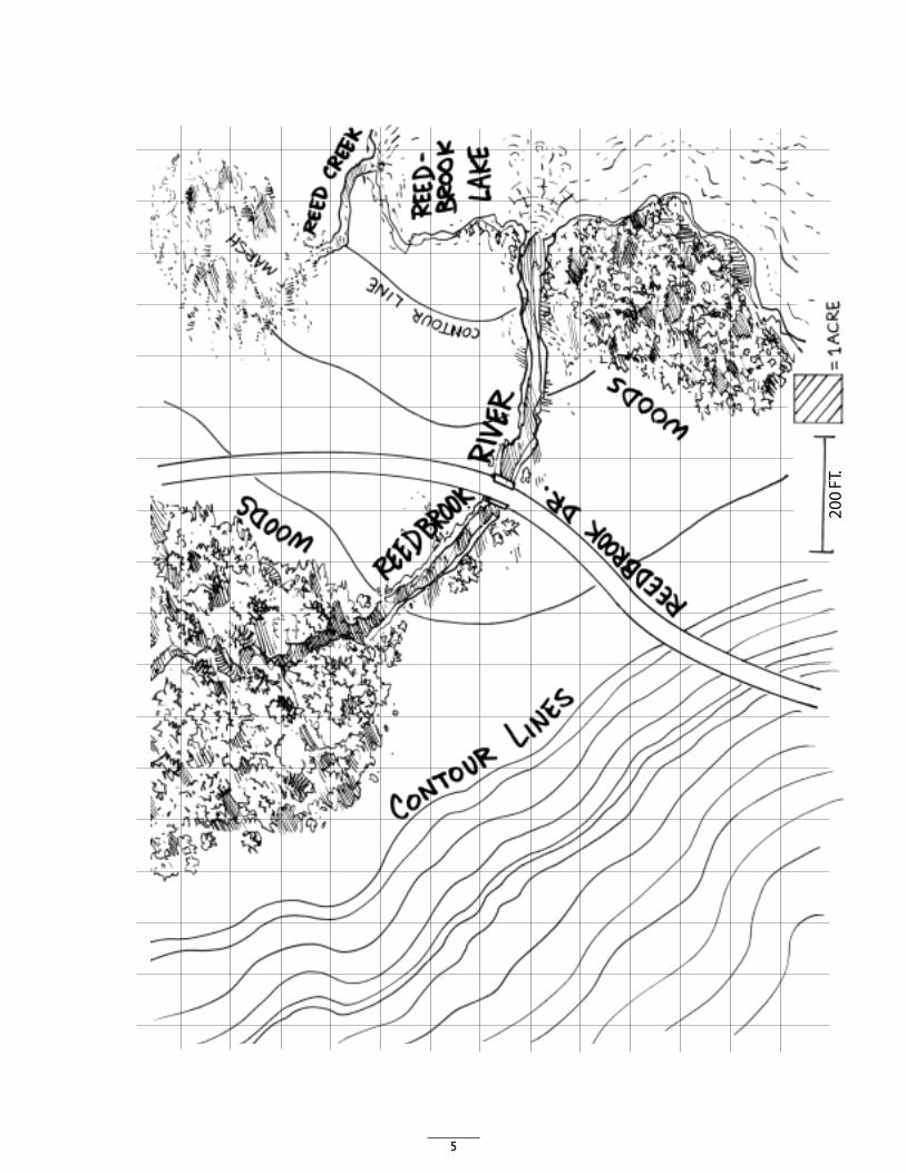
The map shows about 344 acres of undeveloped land with 4 squares equaling one acre. Each square is 100 feet by 100 feet. Contour lines show 20 feet elevation changes. Reedbrook Drive connects with the main road which leads to Reedville 7 miles away. There are two forested areas and a wetland marsh near Reedbrook Lake. There are two water sources: Reed Creek which drains from the marsh to the lake and Reedbrook River which originates in the woods. The water quality is good and people enjoy fishing and swimming in the lake.
The development plan for your group is contained in the separate envelopes. All the instructions you will need are included. Each envelope is numbered in the order you are to open and use it. Divide the envelopes equally among your group, taking partners if necessary. Read the envelope contents one at a time. Draw the land uses on the map. Use your best judgement in placing fields and buildings, because once it is placed on the map, you are not allowed to make any changes.
You must build roads to service all of the land uses.
If you do not have enough land in one area, developments may be separated and located in various sections of the map.
Wetlands may be drained in this land area activity for housing and agriculture development. However, several drainage ditches must be constructed. Draw the ditches as a line with an arrow showing the flow from the wetlands to the river.
Developments can be placed in the woods. It will be necessary to cut some trees and dispose of the wood, branches and stumps.
Student Group A
General Instructions
The Site
Developing the Land
Roads
Separate Developments
Wetlands
Wooded Areas
Read and follow these instructions first:1. Your land will be developed one step at a time. Complete ALL instructions and land use drawings
from one envelope before opening the next envelope. 2. Open one envelope at a time beginning with the envelope marked with a number 1. 3. Complete the instructions before opening the next envelope. 4. Open all envelopes in order. 5. Each student will take a turn opening and reading the contents of the envelopes to the group. This
student will make the necessary decisions, but can receive advice from others in the group if they choose.
6. Use all six envelopes.
The map represents some undeveloped land. You will be developing the land and drawing the land uses on this map. Once all of your land uses are drawn on the map, enlarge it on the butcher or freezer paper and attach it to the poster board. Label the map with your group letter and the name you gave your community.
A section containing a description of the potential environmental effects of certain land uses in included at the end of these instructions. You may study this information, but you do not have to use it in making the development decisions.
The map shows about 344 acres of undeveloped land with four squares equaling one acre. Each square is 100 feet by 100 feet. Contour lines show 20 feet elevation changes. Reedbrook Drive connects with the main road which leads to Reedville seven miles away. There are two forested areas and a wetland marsh near Reedbrook Lake. There are two water sources: Reed Creek which drains from the marsh to the lake and Reedbrook River which originates in the woods. The water quality is good and people enjoy fishing and swimming in the lake.
The development plan for your group is contained in the separate envelopes. All the instructions you will need are included. Each envelope is numbered in the order you are to open and use it. Divide the envelopes equally among your group, taking partners if necessary. Read the envelope contents one at a time. Draw the land uses on the map. Use your best judgement in placing fields and buildings. After a development is placed on the map, you are not allowed to make any changes.
You must build roads to service all of the land uses.
If you do not have enough land in one area, developments may be separated and located in various sections of the map.
Wetlands may be drained in this hypothetical land area for housing and agriculture development. Indicate drainage ditches by drawing a line from the wetlands to the river.(NOTE: There are environ-mental regulations restricting wetlands draining.)
Developments can be placed in the woods. If the lot sizes are one acre or less, it will be necessary to cut some trees and dispose of the wood, branches and stumps.
Student Group B
General Instructions
Draw the Land Uses
Study the Environmental Effects
The Site
To Play
Roads
Separate Developments
Wetlands
Wooded Areas
7
This information tells how land use decisions affect the quality of nearby water resources. You do not have to follow this information.
1. Homes with septic systems should be located at least 500 feet from surface water to prevent septic effluent from polluting the water. Septic systems should be located downhill from wells and springs and at least 100 feet away.
2. Gullies that form in steep terrains increase soil erosion that can pollute many gallons of surface water with pesticides, fertilizers, and other wastes. Planting grass and other vegetation in the gullies can help filter the soil and other pollutants out of the surface runoff. To draw a grass waterway on the map, make diagonal green lines about 50 feet wide for the length of the gully.
3. Animal waste runoff from feedlots can pollute the surface water with nitrates and other contaminates. Feedlots should be at least 1,000 feet from surface water.
4. The way crops are planting on the land can affect soil erosion and water quality. On land that has a slope of five percent or greater the crops should be planted in strips parallel to the contour of the land. The strips should be 100 feet wide and can alternate with other crops. To show this method of planting crops on the map, draw fields in stripes of not more than 100 feet wide and parallel to the contour of the land.
Student Group B Potential Environmental Effects of Certain Land Uses
8
Read and follow these instructions first:1. Open one envelope at a time beginning with the envelope marked with a number 1. 2. Open all envelopes in order. 3. Read all six envelopes.
Select one person in the group to represent the local zoning board. This person will ensure that land uses that could pollute the water are properly sited. Before any member of the group draws the development on the map, the zoning board representative must be asked for a permit to place the development on the site chosen. A permit will be issued if the development does not violate any of the regulations.
Your land will be developed by looking at all of the required developments. Each player will take a turn opening and reading the envelopes. This student will make the necessary decisions using the advice of the other members of the group. Plan the best site for all developments before you begin to draw on the map.
The map shows about 344 acres of undeveloped land with four squares equaling one acre. Each square is 100 feet by 100 feet. Contour lines show 20 feet elevation changes. Reedbrook Drive connects with the main road which leads to Reedville seven miles away. There are two forested areas and a wetland marsh near Reedbrook Lake. There are two water sources: Reed Creek which drains from the marsh to the lake and Reedbrook River which originates in the woods. The water quality is good and people enjoy fishing and swimming in the lake.
The development plan for your group is contained in the separate envelopes. Any instructions you will need are included. Each envelope is numbered in the order of use. Divide the envelopes equally among your group, taking partners if necessary. Open all of the envelopes and read them before proceeding. Plan your development before you put them on the map. To develop the land, carefully follow the regulations provided.
You must build roads to service all of the land uses.
If you do not have enough land in one area, developments may be separated and located in various sections of the map.
Wetlands may be drained in this hypothetical land area for housing and agriculture development. Indicate drainage ditches by drawing a line from the wetlands to the river.(NOTE: There are environ-mental regulations restricting wetlands draining.)
Developments can be placed in the woods. It will be necessary to cut some trees and dispose of the wood, branches and stumps.
Student Group C
General Instructions
Read and Follow the Regulations
Draw the Land Uses
The Site
To Play
Roads
Separate Developments
Wetlands
Wooded Areas
9
These regulations must be strictly followed.
1. Homes with septic systems should be located at least 500 feet from surface water to prevent septic effluent from polluting the water. Septic systems should be located downhill from wells and springs and at least 100 feet away, 100 feet from a well, and 50 feet from a property line.
2. Gullies that form in steep terrains increase soil erosion that can pollute many gallons of surface water with pesticides, fertilizers, and other wastes. Planting grass and other vegetation in the gullies can help filter the soil and other pollutants out of the surface runoff. To draw a grass waterway on the map, make diagonal green lines about 50 feet wide for the length of the gully.
3. Animal waste runoff from feedlots can pollute the surface water with nitrates and other contaminates. Feedlots should be at least 1,000 feet from surface water.
4. The way crops are planted on the land can affect soil erosion and water quality. On land that has a slope of five percent or greater the crops should be planted in strips parallel to the contour of the land. The strips should be 100 feet wide and can alternate with other crops. To show this method of planting crops on the map, draw fields in stripes of not more than 100 feet wide and parallel to the contour of the land.
Student Group C Regulations for County Board Member
Land Use Controls and Management Activity Regulations
10
Land Use Cards
Charles Burns has saved money for years to invest in a small farm. “Build” Charles’s farm according to the instructions listed below. Remember: one acre equals four squares on your map.• Shade in with gray, ¼ acre for a house • Shade with red, ½ acre for a barn• Shade with brown, 5 acres for a feedlot for the 40 head of cattle• Shade with green, 5 acres for pasture• Shade with yellow, 10 acres for corn• Shade with purple, 10 acres for soybeans• Using black, draw in the roads to the main highway. Be sure you can get to all of the fields
Tommy T. Tuttle has inherited about 46 acres of land and wants to settle down and live the good life. Build the Tuttle Farm.• Shade in gray, ¼ acre for a house• Shade in red, ½ acre for a barn• Shade with brown, 5 acres for a feedlot for 55 head of cattle• Shade with green, 10 acres for pasture and grass• Shade with yellow, 15 acres for corn• Shade with orange, 15 acres for alfalfa• Using black, draw in the roads to the main highway. Be sure you can get to all of the fields
Millie Sue and Don Duckley have been farming for many years and decided to sell their farm to a developer and retire to Hawaii. Build the 30-acre subdivision.• Shade gray, ¼ acre for each of the 20 houses• Shade green, ¾ acre for the grass around the houses• Shade blue, 7 acres for the pond, and green for the 3 acres for the park around the pond. Include
walking trails and bike paths in tan• Using black, draw in the roads to the main highway. Be sure all of the houses and the park are
connected
Charles Burns recently married Ann McQuire and they have decided to expand the farm Charles bought. • Using brown, expand the feedlot by 7 acres• Using green, expand the pasture by 10 acres• Using yellow, add 5 more acres of corn• Using orange, add 5 acres of alfalfa• Using black, shade in the connecting roads to the new fields
Inside Envelope 1
Inside Envelope 2
Inside Envelope 3
Inside Envelope 4
#
#
#
#
11
Tommy Tuttle finds farming a good way of life and wants to expand his farm.• Expand his feedlot by 10 acres to take care of more cattle• Add 10 more acres of corn
More and more people think the good life is in a natural setting and want to move to the Duckley’s development. They will need an additional 20 acres.• Build 10 more houses• Build a 10-acre shopping center with a paved parking lot (shade black) and a 3-acre strip of stores
(shade tan)• Add 4 acres of green trees and grass within the parking lot
Read First
Open only one envelope at a time.Complete all instructions before moving to the next envelope.Begin with the envelope marked #1
Read First
Open only one envelope at a time.Complete all instructions before moving to the next envelope.Begin with the envelope marked #1
Cards for Group C are the same as the other two groups. There is no Read First card. Those details are included in the general instructions.
Land Use Cards
Read First Cards
Inside Envelope 5
Inside Envelope 6
Student Group A
Student Group B
Student Group C
#
#
#
#
#
#
12
13
Land Use Practices
Many rural homeowners depend on onsite waste disposal system because municipal waste water treatment systems are not accessible. Nationally, there are more than 24.7 million households using some type of onsite waste disposal system. In Virginia, over two million citizens rely on septic systems. The U.S. EPA estimates that over one trillion gallons of waste is disposed of through septic systems yearly and is a major source of groundwater contamination. Improper siting and system failures can cause wastewater to be carried to inadequately sealed wells or to lakes and streams polluting both ground and surface waters with bacteria, nutrients and toxic household chemicals and waste.
Surface water runoff from croplands can carry pesticides and fertilizers with the soil into surface waters. In areas where there is significant rainfall, plowed fields can increase soil erosion. The mountainous regions of the western part of Virginia have the highest erosion losses. An estimated 43 million tons of top soil are lost each year. The largest pollutant that enters the water is sediment and cropland erosion is the most significant source. Soil erosion practices such as strip cropping, no-till farming, and grassy waterways can reduce the lost of valuable soil. These practices also help protect water quality by preventing the movement of sediment and other pollutants from croplands to waters.
Animal feedlots are areas where animals are confined for feeding, breeding, raising or holding purposes. They can be located outside or in a building and do not require pasture lands. Today, more farms are building larger more specialized feedlots for poultry and livestock. These areas can cause significant pollution problems. Animal wastes from feedlots, improperly constructed or leaking manure storage tanks and pits can contaminate both ground and surface water. High levels of nitrates in water have been associated with improper storage of animal wastes. High levels of nitrates in water can be dangerous to humans and animals.
Deicing materials used to keep roads and highways safe can contaminate water. Salt used in winter to melt ice on roads in rural and urban areas poses a threat when it is washed into surface waters. Improperly stored stockpiles of these materials (salt mixed with sand and gravel) can render the water unfit for humans or livestock. Runoff from paved surfaces such as highways, parking lots, and community streets contain many other pollutants such as gasoline, motor oil, antifreeze and tire byproducts. Pollutants from urban storm water systems include nitrates, bacteria, litter, soil, toxic chemicals, and automobile products. In urban areas the runoff from impervious surfaces is a greater pollutant than municipal sewage.
The water quality in forested areas is usually of very high. Effective forestry management practices help protect surface waters. Improperly managed forestry activities and harvesting can cause damage to sensitive ecosystems and water resources. Road construction, clear cutting, stacking and loading operations during harvests, and controlled burning to prepare sites for planting or reduce the threat of forest fires can transfer the pollutants from the land to the water. Effective forestry operations can protect water quality from the impacts of forestry activities.