Page 1 of 23 Swan Hill South West Development Precinct Planning Report for Planning Scheme Amendments C58, C60, C61, C62, C63 and C64 (This report is prepared for the above six amendments) Swan Hill Rural City Council May 2015
Transcript
Page 1 of 23
Swan Hill South West Development Precinct
Planning Report for
Planning Scheme Amendments
C58, C60, C61, C62, C63 and C64
(This report is prepared for the above six amendments)
Swan Hill Rural City Council
May 2015
Page 2 of 23
Table of contents Pages
Contents 2
INTRODUCTION 3
Background 3
Land within the SWDP 4
Current zoning and land uses within SWDP 5
Overlays affecting the SWDP 7
Surrounding land uses
7
STRATEGIC POLICY BACKGROUND 8
State Planning Policy Framework 8
Council Plan 2013-2017 11
Local Planning Policy Framework 11
Relevant adopted strategies 12
Urban Development Program 2013, Regional Residential Report – Swan Hill
13
CONSULTATION 14
Consultation prior to the commencement of the amendment. 14
Proposed consultation during public exhibition
16
PLANNING SCHEME AMENDMENT
16
INFRASTRUCTURE PROVISION 18
Existing infrastructure and buildings 18
Proposed Infrastructure 18
Infrastructure Standards 19
Infrastructure Requirements 19
Community infrastructure 20
Service Provision
20
IMPLEMENTATION
21
REFERENCE DOCUMENTS
21
Page 3 of 23
Swan Hill South West Development Precinct
Planning Scheme Amendments C58, C60, C61, C62, C63 and C64
Introduction
The purpose of this report is to provide background information for Amendments C58, C60,
C61, C62, C63 and C64 to Swan Hill Planning Scheme. These amendments are proposed to
rezone 18 parcels of land within the Swan Hill South West Development Precinct (SWDP) to
facilitate the supply of residential zoned land to meet the housing needs of future
communities. These amendments also propose new Schedules to Development Plan
Overlay (DPO6, DPO7, DPO8, DPO9, DPO10 and DPO11) to implement the Master Plan
prepared for the SWDP and to achieve orderly development outcomes within the precinct.
Background
The Swan Hill Residential Development Strategy 2006 identified the SWDP as the suitable
area for future residential development for the Township of Swan Hill. Accordingly Swan Hill
Rural City Council (SHRCC) in consultation with landowners developed a draft Development
Plan, Drainage Plan and associated background documents1 towards an amendment
process. However due to various reasons including estimated cost associated with
stormwater management within the precinct the project has not been proceeded with.
In 2009, Council has commenced the Review of the Swan Hill Residential Development
Strategy. This Strategy while reviewed the previous residential strategy, it also investigated
further opportunities for residential land supply. The revised Strategy was adopted by
Council at its meeting in March 2013. The Strategy provides directions for future residential
development in the municipality and recommends that the previously prepared draft Outline
Development Plan for the SWDP to be reviewed.
The current SWDP project includes the review of the previously prepared draft Outline
Development Plan, review of the previously prepared drainage plan, stormwater
management plan, and develops suitable cost sharing mechanism for the provision of future
development infrastructure within the precinct via a series of section 173 agreements under
the Planning and Environment Act 1987or landowners should provide an alternative option
for the provision of infrastructure to the satisfaction of the Responsible Authority.
In reviewing the previously prepared draft Outline Development Plan, in consultation with the
landowners and relevant State agencies Council has prepared a Master Plan for the South
West Development Precinct. This Master Plan will be exhibited at the same time of the first
amendment to be exhibited for the SWDP.
1 Draft Outline Development Plan was prepared by David Lock and Associates in association with Aurecon Previous Stormwater Drainage Schematic Design Study was prepared by Aurecon , and The previous Development Contributions Plan was prepared by SGS Economics and Planning
Page 4 of 23
Master Plan for the South West Development Precinct
The draft Master Plan for the SWDP provides directions for the orderly land use and
development outcomes of the precinct. It identifies the required collector roads, key
intersections, shared paths, street trees, areas for future bus stops, an area suitable for a
neighbourhood activity centre (Commercial 1 Zone), areas to be retained in respective
current zones, buffer distance from adjoining properties that are used for non-residential
uses, minimum lot sizes for lots fronting and or abutting land within Farming Zone and Low
Density Residential Zone, current overlays to be removed (DPO 2 within the Precinct) and
locations for gateway features. The Master Plan encourages medical centres, childcare
centres and aged care facilities within the precinct.
The Master Plan also indicates that the Goulburn Murray-Water channel will be
decommissioned and locations for the proposed Lower Murray Water and Goulburn-Murray
Water pump stations. Decommissioning of the Channel, provision of the pump stations and
the locations are dependent upon the respective authorities’ final decision.
The proposed new schedules to the Development Plan Overlay (to the Clause 43.04) will
ensure orderly land use and development outcomes and accurate implementation of the
Master Plan at no cost to Council.
Land within the SWDP
The table below shows the entire land within the SWDP. Total area of land within the
Precinct is approximately 244.33ha, of which the Council owned and managed Ken Harrison
Reserve and the Feldtmann Reserve both zoned Public Park and Recreation Zone (PPRZ)
are approximately 17.3ha and 3.8ha respectively. Ken Harrison Reserved will be retained
as PPRZ.
Address Lot No TP/PS/LP Size ha Comments
69 Sea Lake-Swan Hill Road, Swan Hill Lot 1 PS 81008 0.1ha Will be retained as Farming Zone due to proximity to IN1Z
71 Sea Lake-Swan Hill Rd, Swan Hill Lot 1 TP 99093V 0.1ha
219 Gray Street, Swan Hill Lot 1 PS 405842S 1.3ha
7 Dead Horse Lane, Swan Hill Lot 1 TP 243546J 2ha
183-187 Gray Street, Swan Hill Lot 1 TP 614559H
0.8ha Will be retained as LDRZ due to its proximity to IN1Z
66 Yana Street, Swan Hill Lot 1 TP 187649H 17.3ha Ken Harrison Reserve will be retained as PPRZ
Feldtmann Lane, Swan Hill Lot 1 LP 131446 3.8ha
Dead Horse Lane, Swan Hill Lot 2 PS 131446 28.3ha
Sea Lake-Swan Hill Rd Swan Hill Lot 2 PS 405842S 20.8ha Part of the land (about 9800sqm) will be retained FZ
Dead Horse Lane, Swan Hill Lot 1 TP 821121W 18.3ha Part of the land (about 1ha) is outside the SWDP in LDRZ.
Dead Horse Lane, Swan Hill Lot 1 TP 821120Y 51.8ha
Page 5 of 23
Address Lot No TP/PS/LP Size ha Comments
183-187 Gray Street, Swan Hill Lot 1 TP 519005 5.7ha Part of the land (about 8000sqm) will be retained LDRZ.
177 Gray Street, Swan Hill Lot 1 TP 814807A 0.4ha
175 Gray Street, Swan Hill Lot 1 TP 519770S 0.5ha
173 Gray Street, Swan Hill Lot 1 PS 424914L 0.9ha
179 Gray Street, Swan Hill Lot 1 TP 539204Q 7.1ha
70 Yana Street, Swan Hill Lot 1 PS 76581 4.4ha
98 Yana Street, Swan Hill Lot 1 TP 179253F 13.9ha
110 Yana Street, Swan Hill Lot 1 PS 99806 4.8ha
116 Yana Street, Swan Hill Lot 1 TP 205402A 4.8ha
235 Dead Horse Lane, Swan Hill Lot 2 PS 124722 13ha
233 Dead Horse Lane, Swan Hill Lot 1 PS 124722 0.8ha
249 Dead Horse Lane, Swan Hill Lot 2 PS 637281M 4.8ha
134 Yana Street, Swan Hill Lot 3 PS 99806 0.6ha
142 Yana Street, Swan Hill Lot 1 PS 75694 0.9ha
148 Yana Street, Swan Hill Lot 2 PS 75694 0.8ha
154 Yana Street, Swan Hill Lot 1 PS 637281M 0.5ha
75 Yana Street, Swan Hill Lot 1 LP117284 3.3ha
75 Yana Street, Swan Hill Lot 2 LP 117284 6.7ha
Coronation Avenue, Swan Hill Lot 18 LP14827 6ha
112 Coronation Avenue, Swan Hill Lot 19 LP 14827 6.1ha
112 Coronation Avenue, Swan Hill Lot 2 LP 205853S 11.4ha
152 Coronation Avenue, Swan Hill Lot 1 LP 205853S 0.8ha
The SWDP also includes land currently used by the Goulbourn Murray Water channel. The
authority is in the process of decommissioning the channel infrastructure and reinstates the
land. However, future developments on land that are reclaimed as a result of
decommissioning of the Goulburn Murray Water Channel infrastructure requires further
investigation to demonstrate the suitability of the land for build on for habitable and other
purposes.
Current zoning and land uses within SWDP
As shown in map below, majority of the land within SWDP is Farming Zone (FZ) with an
exception to land along the south side of Gray Street, east of Yana Street and west of
Coronation Avenue which are zoned Low Density Residential Zone (LDRZ).
Most of the land within the precinct are predominantly used for combination of dry land and
irrigated farming. Small FZ parcels along west side of Yana Street are used for residential
purpose. Smaller parcels of land zoned LDRZ along the southern side of Gray Street are too
used for residential purposes while the lager parcels of along this section are used for
farming activities.
Page 6 of 23
Swan Hill South West Development Precinct and Current Zoning
Small parcels of FZ land that located on south west corner of Gray Street and Swan Hill –
Sea Lake Road are too being used for residential purposes (69 Sea Lake-Swan Hill Road,
71 Sea Lake-Swan Hill Road and 219 Gray Street, Swan Hill). However, it is believed that
these properties are located within the minimum setback requirements specified in Clause
52.10 of the Swan Hill Planning Scheme to the existing industrial activities on the east side
of Gray Street. This 100 metre setback was measured from the polystyrene products
operation at No. 2-4 McAllister Road, Swan Hill. As such these land cannot be rezoned for
residential purposes and will be retained FZ. The landowners were advised of this matter
and were invited to justify if they believe their land should be included in the residential
zoning.
When applied the same setback requirements to Lot No. 2 PS 405842 Sea Lake- Swan Hill
Road, it is found a 70metre setback was required inside the property to make up the
100metre setback from the above polystyrene products activity, this setback is 20 meters
more than what the landowners proposed. This setback within Lot No. 2 PS 405842 Sea
Lake- Swan Hill Road will also be retained Farming Zone as indicated in the draft Swan Hill
South West Development Plan.
The land located at the south east corner of Dead Horse Lane and Swan Hill – Sea Lake
Road (No. 7 Dead Horse Lane, Swan Hill) will also be retained FZ. Due to the history of its
previous uses, an environmental audit of the site is required prior to the land can be
considered for residential rezoning. Representatives of the owners of the land have been
advised of this issue and were invited to submit an environmental audit to justify the
Page 7 of 23
suitability of the land for residential zoning. This land will also be retained as FZ until the
above matter is addressed.
Further, a 15 metre buffer is proposed on the adjoining land to protect the future residential
amenity from activities of this FZ land.
The LDRZ properties along the southern side of Gray Street that are within the SWDP were
invited to justify their suitability and required minimum setbacks as per the requirements
Clause 52.10 of the Swan Hill Planning Scheme. Information provided by landowners claims
these properties are located outside the minimum setback. However, it is noted that as per
the requirements of Clause 52.10 the concrete batching use at No. 9 Quin Drive, Swan Hill
requires 300 metre setback from residential uses.
As such the entire Lot No. 1 TP614559 and the northern section of Lot No.1 TP519005 both
properties known as No. 183-187 Gray Street could not be rezoned from LDRZ to GRZ as
they are located within the 300 metre setback. The remaining southern section of Lot No.1
TP519005 (outside the existing dwelling and associated outbuildings) will be rezoned to
GRZ.
The Council owned Ken Harrison Reserve is zoned PPRZ and used for recreational
activities and will be kept as PPRZ. The Master Plan for SWDP identifies this reserve as a
public open space for future residential uses. The Reserve currently fronts to Yana Street.
Relevant schedules to the Development Plan Overlay require providing linear pedestrian
access to the Reserve from SWDP. In addition, the proposed collector roads and the shared
paths are too designed to provide linear, efficient and safe access to Ken Harrison Reserve
from the development.
The Open Space Contribution collected from future developments will be used to upgrade
the facilities at Ken Harrison Reserve as identified in the approved Master Plan for the
Reserve.
The Council owned and managed Feldtmann Reserve located within the SWDP is currently
used by a Pony Club. This reserve will be rezoned for residential purpose and the Pony
Club will be relocated to the exiting Equestrian Facility at E.F. Butler Reserve in Tyntynder
South or another suitable location.
Overlays affecting the SWDP
There are three overlays affecting the land within the SWDP. Development Plan Overlay –
Schedule 2 (DPO2) affects the land zoned LDRZ which will be removed as part of the
amendments to the SWDP. New Schedules and new DPOs are proposed to all land to be
rezoned for residential purpose within SWDP.
The southern boundary along Werril Street of the SWDP is affected by Airport Environs
Overlay (AEO) and a Design and Development Overlay (DDO). These overlays will be
retained.
Page 8 of 23
Overlays currently affecting the SWDP
Surrounding land uses
Most of the surrounding uses along the north and western sides of the Precinct are
residential, with an exception of the industrial uses on the north east corner of Gray Street,
the Council owned reserve and the Swan Hill Primary School both located south of Gray
Street. These lands are zoned Public Use Zone -PUZ 6 and PUZ2 respectively. Uses along
the west of Dead Horse Lane and the south of Werril Street are predominantly farming with
exception to residential activities towards the east end of Werril Street.
Sea Lake- Swan Hill Road borders a section of the northern boundary of the Precinct zoned
Road Zone Category 1 (RD1Z). Majority of the eastern half of the northern boundary is
bounded by Gray Street zoned both Industrial 1 Zone and LDRZ. Dead Horse Lane and
Werril Street border the western and southern boundaries of the Precinct respectively,
whereas Coronation Avenue, a section of Yana Street and various private properties border
the eastern boundaries of the Precinct. A section of Yana Street also runs north-south
through the Precinct and zoned Road Zone Category 2 (RD2Z).
The proposed Schedules to the DPO where necessary specify minimum lot sizes to areas
abut to existing residential uses to minimise the number of properties that could back on to
the exiting Low Density areas. Similarly, the Schedules where necessary propose section
173 agreements to land that about to Farming Zone to acknowledge the ongoing farming
activities.
Page 9 of 23
Strategic policy background
State Planning Policy Framework (SPPF)
The proposed rezoning and future residential and associated developments within the
SWDP are consistent with the SPPF. Clause 11 (Settlement) of the SPPF states that:
“Planning is to anticipate and respond to the needs of existing and future communities
through provision of zoned and serviced land for housing, employment, recreation and open
space, commercial and community facilities and infrastructure. Planning is to recognise the
need for, and as far as practicable contribute towards:
Health and safety.
Diversity of choice.
Adaptation in response to changing technology.
Economic viability.
A high standard of urban design and amenity.
Energy efficiency.
Prevention of pollution to land, water and air.
Protection of environmentally sensitive areas and natural resources.
Accessibility, and
Land use and transport integration.
Above directions from the SPPF are acknowledged, recognised and incorporated in the preparation of the SWDP Master Plan and the associated Schedules for the DPO.
Rezoning of the selected parcels of land within the SWDP is a proactive response by Council to the needs of existing and future communities. The proposed rezoning provides appropriately zoned and serviced land for housing. It will also generate direct and indirect employment opportunities during development, and will enhance the recreation and open space facilities, facilitate the provision of commercial and community facilities and necessary infrastructure for future communities.
Clause 11.02 (Urban Growth) within the SPPF requires “to ensure a sufficient supply of land
is available for residential, commercial, retail, industrial, recreational, institutional and other
community uses”. As identified by the Review of the Swan Hill Residential Strategy 2013,
the main aim of the rezoning of land for residential uses within the SWDP is to ensure the
supply of appropriately zoned residential land to meet the current and future communities of
Swan Hill.
The clause also emphasises the importance of infrastructure to support sustainable urban
development. The proposed DP for the SWDP ensures the provision of relevant
development and community infrastructure are planed and provided in the Precinct.
Infrastructure that is identified and planned for includes collector streets, internal streets,
shared paths, bus stops, public open space, upgrades to existing intersections, retardation
Page 10 of 23
basins, overland flow paths for managing stormwater, and a retail area for convenience
stores.
Standards and quality of development infrastructure provided within the Precinct will be in
accordance with the standards specified within the Local Government Infrastructure Design
Manual (version as updated).
In addition, to the above, the DP recognises the need for and supports the provision of aged
care facilities, child care centres and medical centres within the SWDP. Use and
development of these facilities and any other relevant social, community and commercial
uses can be supported within the Precinct as needed and as per the requirements of Swan
Hill Planning Scheme.
Requirements of Clause 15 Built Environment and Heritage have been considered in the proposed new Schedules to DPO - Clause 43.04 ensure orderly development outcomes as per the requirements of the proposed General Residential Zone. No heritage overlay affecting the SWDP.
Clause 11.11 Loddon Mallee North Regional Growth Plan (SPPF)
The LMNRGP was adopted by Council in November 2013 as it was by other four
municipalities within the Loddon Mallee North Region. The Plan amongst other things
recognises the need for appropriately zoned land to meet the increasing need of variates of
residential uses in the region. The Plan recognises Swan Hill as a Regional Centre that
services a wider catchment beyond its municipal boundaries and its stronger relationships
with New South Wales, South Australia and adjoining Victorian regions.
The Plan supports incremental expansion of Swan Hill and the provision of infrastructure to
facilitate population and economic growth, including improvements to transport infrastructure
to service regional industries. It emphasises the need for integrated strategic planning to
support for growth and enable healthy and supportive communities.
It acknowledges the SWDP being identified for the provision of future residential land supply,
and provides particular reference to the SWDP as the identified growth area and encourages
new residential development to accommodate future growth. The development outcomes of
the rezoned area will contribute to strengthen Swan Hill as a strong regional centre.
It also recognises continues increase in housing prices, affordable and sustainable housing
needs, quality and standards of development infrastructure, the need to create places that
encourage active and healthy living and integrated development that encourage use of
public transport.
The proposed Master Plan for the SWDP and the Schedules to DPO will ensure the
achievement of the above goals outlined in the LMNRGP and quality development
outcomes.
Clause 16 (Housing) of the SPPF specifies that:
Page 11 of 23
Planning should provide for housing diversity, and ensure the efficient provision of
supporting infrastructure.
New housing should have access to services and be planned for long term sustainability,
including walkability to activity centres, public transport, schools and open space.
Planning for housing should include providing land for affordable housing.
The proposed DP for SWDP carefully considers the above directions including the provision
of necessary development and social infrastructure, long-term sustainability, encourage
walkability by the provision of shared path, provision of bus stops for future public transport,
the and provision of and efficient access to open spaces within the Precinct. It also aims to,
and supports the supply of affordable housing by encouraging small residential lots in
suitable locations with appropriate orientations. These will not only ensure affordability
during purchase, but will also be affordable live in these as houses as the right orientation
will reduce the cost of heating and cooling in different seasons and allow natural light and
ventilation into the houses.
As outlined in Clause 17 Economic Development of SPPF the amendment will have positive impact on the local economy. There will be direct and indirect job opportunities created during the construction of future developments. In addition, the proposed retail activity area, medical centre, aged care facility and child care centre will bring permanent employment opportunities to Swan Hill.
Objectives of Clause 18 Transport of SPPF have been considered in the SWDP Master Plan and Schedules for DPO. The proposed Master Plan identifies the need and allocates land for the provision of six bus stops (on three key locations) along the main collector road that runs through the Precinct. Proposed Schedules to DPO encourage increased densities along collector roads and closer to the activity areas to maximise the use of public transport service when it becomes available. In addition, the draft Master Plan proposes shared paths that can encourage and support alternative and sustainable transports models like walking and cycling.
Similarly the objectives of Clause 19 Infrastructure of SPPF have been incorporated in the Master Plan and in the new Schedules to DPO. The Master Plan provides directions for the orderly land use and development outcomes of the precinct. It proposes and facilitates the provision of necessary development infrastructure and encourages the efficient use of existing infrastructure that is already servicing the surrounding areas of Swan Hill Township. In particular it shows the proposed collector roads, key intersections, proposed shared paths, street trees, areas for future bus stops and locations for gateway features. The Master Plan also indicates Goulburn Murray-Water channel to be decommissioned,
locations for the proposed Lower Murray Water and Goulburn-Murray Water pump stations.
Decommissioning of the Channel, provision of the pump stations and the locations are
dependent upon respective authorities’ final decision.
Further the Master Plan encourages social and community infrastructure including medical and childcare centres, aged care facilities and an area suitable for neighbourhood activity centre (Commercial 1 Zone).
Page 12 of 23
The proposed new schedule to the Development Plan Overlay (DPO6) includes
necessary requirements to ensure the provision of development infrastructure and appropriate social and community infrastructure as identified in the Master Plan to the standards specified in the adopted Infrastructure Design Manual.
Council Plan 2013-2017 - Council’s vision for housing
Council Plan 2013 – 2017 sets out Council’s targets for service delivery and provides
strategic directions to achieve them. It emphasises the need to support appropriate
accommodation options for the growing economy, and aims to complete respective
amendments to the Swan Hill Planning Scheme to support the supply of future housing.
The Council Plan also states that Council is seeking to grow the regional population to
40,000 by 2040 (also referred in Clause 21 of the Swan Hill Planning Scheme). The
proposed residential rezoning will contribute to achieve this goal by facilitating the supply of
residential land.
Local Planning Policy Framework (LPPF)
The LPPF of the Swan Hill Planning Scheme consists of two major clauses. Clause 21
being the Municipal Strategic Statement (MSS) and Clause 22 contains local (planning)
policies.
Clause 21.02 (Settlement) recognises that:
Moderate population growth is expected in Swan Hill and Robinvale.
The size of households has declined over time and is consistent with general national
trends.
The population is ageing and will require a diversified housing stock.
The proposed rezoning of land within the SWDP will increase the supply of residential zoned
land to meet the housing needs of the growing population. Decline in household size with
increase in population means more demand for variety of housing types including one to two
bedroom units and townhouses as generally small households prefer this type of
accommodations. Equally the aging population also means increasing needs for low-
maintenance small houses for downsizing, and increasing demand for variety of retirement
villages and age care facilities, including lifestyle living, independent living units, high-care
facilities and palliative care units. The Master Plan for the SWDP recognises the need for
and encourages aged care facilities within the Precinct.
Clause 21.02 (Key Influences and Issues) of the MSS highlights the need for facilitating residential and economic development and maximising the use of existing infrastructure. In particular, Clause 21.02-2 (Settlement and housing) recognises “the provision of an alternative to Tower Hill in Swan Hill as a new residential development front”. The proposed development within the SWDP provides alternative residential fronts for the Township of Swan Hill.
Page 13 of 23
Proposed rezoning within the SWDP will achieve the settlement and housing objectives of Clause 21.04 of the MSS by ensuring the supply of appropriately zoned residential land for future housing to locate in the major regional centre of Swan Hill. The Clause highlights the need for an Outline Development Plan for the Swan Hill South West Development Precinct to facilitate future residential development. The proposed Master Plan and this amendment fulfil this requirement.
Clause 21.04-4 for Orderly growth of towns and settlements of the MSS - highlights the
need for an Outline Development Plan for the Swan Hill South West Development Precinct to facilitate future residential development. The proposed Master Plan for the SWDP fulfils this requirement.
Proposed rezoning supports Council’s economic development objectives outlined in Clause 21.08 of the MSS by encouraging appropriate non-residential uses within the SWDP. In addition direct and indirect job opportunities will be created during the development of the area.
Swan Hill Urban Framework Plan in Clause 21.10-1 of the MSS identifies SWDP as the area for long-term urban development opportunities. It emphasises the need for a structure plan providing directions for future development of the area. The proposed Master Plan for the SWDP aims to provide directions for orderly development outcomes. Further the rezoning will support the enhancement of Swan Hill as a strong regional centre.
Relevant adopted strategies
The Review of Swan Hill Residential Development Strategy 2006-2013 identifies SWDP for future residential development. Council adopted the Strategy in March 2013. The Strategy provides directions for future residential developments in the municipality. Council when adopting the Strategy recommended that the previously prepared draft Development Plan for the SWDP be reviewed. Accordingly the previously prepared draft Outline Development Plan and associated documents have been reviewed. The revision informed the development of the Master Plan for the South West Development Precinct.
The majority of the land within the SWDP is zoned Farming and Low Density Residential zones. A planning scheme amendment is required to implement the strategic directions of the Review of the Swan Hill Residential Strategy 2013, in particular to rezone land within the South West Development Precinct to facilitate the supply of future residential zoned land and associated uses as identified in the Master Plan for the South West Development Precinct.
The Residential Strategy estimates residential growth and demand for up to 2013. It
examines seven scenarios and provides seven options (Option A to G) for future residential
rezoning of land within the SWDP. Council when adopting the Strategy in March 2013
resolved to support Option D which includes:
Ongoing infill residential development;
Continued development at Tower Hill; and
Rezoning and residential development at the South West Development Precinct.
Page 14 of 23
According to Option D, a total of 315ha of land are to be rezoned (192ha of General Residential Zone and 123ha of Low Density Residential Zone to yield 1606 and 1859 of General Residential and Low Density Residential lots respectively)
Although the Strategy suggests mixture of GRZ and LDRZ for the SWDP, Council chooses
to use only GRZ for the following reasons.
o Lower Murray Water the authority responsible for sewer and water is supportive
of the amendment and confirmed that SWDP could be serviced with reticulated
sewer and water.
o To provide fair and equal opportunity to all landowners (big and small) within the
precinct opportunity to develop. There are total of 23 private landowners within
the precinct who have experienced many delays in attempts to rezone this land.
The previous attempts were based on a mixture of LDRZ and Residential 1
Zone (former zone) which in Council’s opinion will make it a difficult task to
stage the development. As such, Council has decided to allow for all land that
can be serviced to be rezoned GRZ and introduced a six separate amendment
approach with Section 173 agreements where landowners within each
amendment area can share the infrastructure cost and develop their land as
they prefer or landowners should provide an alternative option for the provision
of infrastructure within each amendment area to the satisfaction of the
Responsible Authority.
o However, as in any development the market will guide and determine the supply
and release of the land.
Public Health and Wellbeing Plan – recognises the need to incorporate Healthy by
Design principles in future residential developments.
Swan Hill Economic Development Strategy 2011-2016 (2011) highlights the importance
of attracting new residents, and encouraging economic activities that can generate
employment opportunities.
Swan Hill Reserves Master Plan – lists the upgrades required for Ken Harrison Reserve.
Urban Development Program 2013, Regional Residential Report – Swan Hill
In addition, the Victorian State Government’s Urban Development Program 2013, Regional Residential Report – Swan Hill provides information on residential supply and demand for the Rural City of Swan Hill. The report identifies opportunities for residential land supply from minor Infill, major infill (such as Tower Hill and SWDP) and rural residential land. According to the report from July 2006 to December 2012, 54% of residential constructions were in minor infill lots, followed by 36% of major infill and 10% from rural residential. Of these 80% of residential lot construction was located within the township of Swan Hill, followed by Robinvale (11%), and Lake Boga (4%).
The report projects the total dwelling requirement for Swan Hill Statistical Local Area (Swan Hill SLA) from 2011 to 2031 to be around 1,821 (91 average per annum). It also recognises an alternative demand projected based on an expressed demand measured in conjunction with growth rates identified in the State Government’s projections which results in an average annual dwelling requirement of 120 dwellings per annum. This is an increase of 31% or 580 dwellings requirements from the above 2011 to 2031 projections.
Page 15 of 23
Based on Council’s residential building approvals from July 2006 to July 2012 the report identifies an average of 108 residential building had been approved per annum. Of these, since July 2006 69% of building approvals (or 76 per annum) has been within the Swan Hill SLA.
The report recognises the availability of appropriately zoned residential land to meet the Victoria in Future 2012 and trend based consumption rates of the municipality. It also recognises the potential future residential stocks from the identified unzoned residential land to meet the longer term requirements. In particular, the report reflects and recognises the draft Outline Development Plan prepared by Council for the SWDP to rezone approximately 214 hectares for residential purpose, with a possible yield of 2,240 lots. The report specifically recognises current planning scheme amendment process for the rezoning of land within the SWDP.
As recognised by the report, for the period from 2012 to 2031, supply of residential lots about 1,697 will come from the identified major infill areas (like SWDP and Tower Hill). In addition to providing the above supply, rezoning of land within SWDP will also provide the alternative residential option to Tower Hill and choice and variety for future residents.
Further, Council’s Master Plan approach to SWDP allows for Council to explore longer term residential requirements and to proactively plan for the need and provision of necessary development, social and community infrastructure within the precinct and its surroundings. SWDP will meet the residential land supply beyond 2031. However, Council’s stage rezoning approach to SWDP will allow Council to continue to monitor the consumption of residential land while ensuring adequate stocks of appropriately zoned land to meet future demand as recognised by the UDF report.
Consultation
Consultation prior to the commencement of the amendment.
During the preparation of the revised Master Plan series of consultation have been
undertaken with the landowners in groups and in one on one meeting; where possible and
appropriate landowners’ requirements have been incorporated into the revised Development
Plan. In addition to the formal meetings, Council Officers met with landowners and their
representatives when needed and or at landowners’ request. Relevant State agencies were
too consulted with and without landowners to promote and facilitate landowners’ interest
without compromising agencies requirements. Further, landowners were kept informed via
written correspondence of the progress of the project.
In addition to the consultation with the landowners, series of consultation were undertaken
with the following State agencies.
Lower Murray Water Authority – No objection and supports the amendment in principle
Goulburn Murray Water Authority – No objections and supports the amendment in
principle
Country Fire Authority – No objections and supports the amendment in principle
Page 16 of 23
VicRoads – The authority does not have any objections to the proposed amendment nor
to the Master Plan, except for providing direct access to Sea Lake – Swan Hill Road.
VicRoads believes that SWDP should have access the Sea Lake - Swan Hill Road via
Dead Horse Lane. VicRoads advises that it does not support new access to be created
within 800m of a major intersection. In this case the proposed new access to Sea Lake -
Swan Hill Road will be within 800m from the existing roundabout at the intersection to
Gray Street and Sea Lake - Swan Hill Road.
However, VicRoads has agreed to consider a new mid block intersection on Sea Lake -
Swan Hill Road from the Precinct only to allow left turn in and left turn out movements.
The authority indicated that this arrangement will require a raised median across the
proposed new intersection and creation of a safe U-turn facility near or at Dead Horse. It
is acknowledged that these works would be expensive as it means constructing
additional through traffic pavements.
VicRoads are also agreeable to consider a left in and left out movement one way service
road located entirely on the subject land with the new road intersecting with, and
terminating onto the one way service road.
It is noted that the traffic impact assessment undertaken by Council for the Master Plan
investigated the issues associated with having a direct access to Sea Lake - Swan Hill
Road and confirm that a safe and convenient full direct access to Sea Lake – Swan Hill
Road can be achieved through design and upgrades to the intersection as per the
requirements of VicRoads.
Requirements for the provision of necessary upgrades as per VicRoads satisfaction have
been incorporated into the Schedule to DPO6 of Amendment C58. During the public
exhibition period, VicRoads will be able to provide formal comments on the proposed
direct access indicated on the Master Plan.
Former Department of Environment and Primary Industries (DEPI) – The authority
supports the proposed amendments in principle. Given the time it could take for some of
the rezoned land to be developed, and the possibility of these land to be continued to
use for agriculture purposes until they are ready for development, it has been deemed
appropriate to undertake the detailed environmental impact assessment of the land to be
rezoned at the time of development (i.e. during the assessment of permit application for
subdivision). DEPI is supportive for environmental impact assessment and soil testing
requirements to be included in the proposed Schedules to the DPO.
Former Department of Transport – The Department encourages increased densities
along the proposed collector road which will act as a public transport route when the
service will become available. The proposed Schedules to DPO encourage increased
densities along the collector roads and around the activity areas.
Aboriginal Affairs Victoria – The authority is supportive of the amendment and informed
there is no known cultural heritage significance within the SWDP. The authority provided
notes to be included in future planning permits in relation to cultural heritage significance,
which have been included in the proposed Schedules to the DPO.
Page 17 of 23
Department of Environment Land Water and Planning – Throughout the development of
the Master Plan the Department had been consulted and kept informed of the progress
of the Plan. The Department will review the amendment documents prior to send for
authorisation. The Department is generally supportive of the amendment.
All the relevant agencies will be formally notified during public exhibition for the
amendments.
In addition to external consultations, relevant internal departments were also consulted
during the development of the Master Plan and background documents. In particular, inputs
were sought from Asset Management Department, Engineering Department, Natural
Resource Management Department, Council Valuer, Economic Development, and
Community Facilitation Unit.
Proposed consultation during public exhibition
Upon receipt of the authorisation, public exhibition will be held for a period of four weeks for
all six amendments. During the public exhibition period, the owners and occupiers of
affected land and the adjoining properties will be notified. And a public notice will be
published at the local news paper the Guardian. A Notice of Amendment will also be
published at the Government Gazette.
Further, amendment documents will be made available at Council website, and Council
Office.
In addition, notices will be sent to the Prescribed Ministers, relevant State agencies and any
other agencies as required by the Minister for Planning during authorisation.
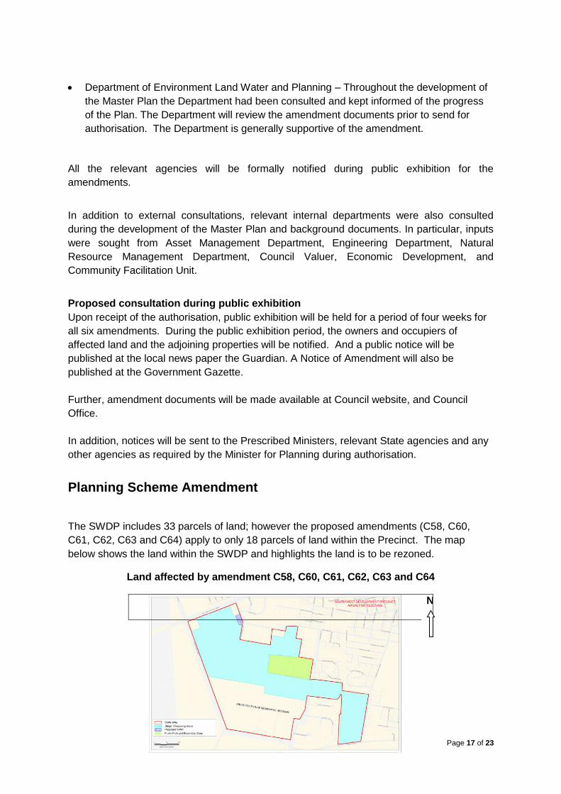
Planning Scheme Amendment
The SWDP includes 33 parcels of land; however the proposed amendments (C58, C60,
C61, C62, C63 and C64) apply to only 18 parcels of land within the Precinct. The map
below shows the land within the SWDP and highlights the land is to be rezoned.
Land affected by amendment C58, C60, C61, C62, C63 and C64
N
Page 18 of 23
Land affected by amendment C58, C60, C61, C62, C63 and C64
Address Lot No TP/PS/LP Approximate Size/ha
Dead Horse Lane, Swan Hill Lot 2 LP 131446 28.3ha
Sea Lake-Swan Hill Road, Swan Hill (part of) Lot 2 PS 405842S 19.8ha
Feldtmann Lane, Swan Hill Lot 1 LP 131446 3.8ha
Dead Horse Lane, Swan Hill (part of) Lot 1 TP 821121W 17.3ha
Dead Horse Lane, Swan Hill (part of) Lot 1 TP 821120Y 8.19ha
183-187 Gray Street, Swan Hill (part of) Lot 1 TP 519005 5.0ha
177 Gray Street, Swan Hill Lot 1 TP 814807A 0.4ha
175 Gray Street, Swan Hill Lot 1 TP 519770S 0.5ha
173 Gray Street, Swan Hill Lot 1 PS 424914L 0.9ha
179 Gray Street, Swan Hill Lot 1 TP 539204Q 7.1ha
70 Yana Street, Swan Hill Lot 1 PS 76581 4.4ha
98 Yana Street, Swan Hill Lot 1 TP 179253F 13.9ha
75 Yana Street, Swan Hill Lot 1 LP 117284 3.3ha
75 Yana Street, Swan Hill Lot 2 LP 117284 6.7ha
Coronation Avenue, Swan Hill Lot 18 LP14827 6ha
112 Coronation Avenue, Swan Hill Lot 19 LP14827 6.1ha
112 Coronation Avenue, Swan Hill Lot 2 LP 205853S 11.4ha
152 Coronation Avenue, Swan Hill Lot 1 LP205853S 0.8ha
TOTAL Approximately 143.89ha
The amendments propose the following:
Rezoning:
Rezones Farming Zone to General Residential Zone
Rezones Low Density Residential Zone into General Residential Zone in maps
Rezones Public Park and Recreation Zone into General Residential Zone (Feldtmann
Reserve)
Rezones Farming Zone to Commercial 1 Zone (proposed retail activity area within the
SWDP)
Page 19 of 23
Overlays:
Amends maps Nos. 36 DPO, 39 DPO and 40 DPO to introduce new DPO for the entire
SWDP
Introduces new Schedules to Clause 43.04 (DPO) for the entire SWDP
Delete DPO Schedule 2 from land within the SWDP, and
Make minor technical adjustment to Schedule 1 to Development Plan Overlay in Clause
43.04 to replace the existing Schedule 1 with a new Schedule 1.
INFRASTRUCTURE PROVISION
Existing infrastructure and buildings
The following street and other infrastructure are currently available within the SWDP.
Goulburn Murray Water Channel No 9 and other small channels
Ken Harrison Reserve - Swan Hill Rural City Council
Equestrian Reserve – Swan Hill Rural City Council
Dead Horse Lane – Rural road
Werril Street – Road Zone Category 2
Yana Street – Road Zone Category 2
Coronation Avenue – Urban road
Gray Street – Urban road
Sea Lake – Swan Hill Road – VicRoads Road Zone Category 1
Feldtmann Lane – unmade local street, and
Existing dwellings and associated outbuildings – private
Proposed Infrastructure
The following infrastructure is proposed to service the SWDP as identified in the Swan Hill
South West Development Precinct Traffic Impact Assessment Report and as indicated in the
Swan Hill South West Development Plan (only for infrastructure within the SWDP).
Collector streets
Intersections and upgrades (Yana Street and new collector street intersection,
Coronation Avenue and new collector street intersection, Gray St , Feldtmann Lane
widening and intersection with Gray Street, Dead Horse Lane Sea Lake Road
intersection.
Collector road exit to Sea Lake - Swan Hill Road shown on the draft Master Plan for
SWDP
Shared paths on both sides of collector streets
Internal streets
Drainage infrastructure including pipes, pits, retardation basins (including
landscaping), rising mains and associated infrastructure
Page 20 of 23
Street trees and footpaths in local streets
Street furniture
Upgrades to the existing Ken Harrison Reserve. Public Open Space contribution
collected from SWDP will be used to upgrade the Ken Harrison Recreation Reserve
in accordance with an approved Master Plan for the reserve and to purchase and
develop a small parcel of land for POS.
75metre X 40metre Commercial 1 Zone land to provide retail activities
Intersection upgrades
Entry features
Street lights
The triggers for provision of common infrastructure are listed in the South West
Development Precinct Contributions to Infrastructure. This document states all intersections
to be provided and upgraded must be carried out at the time of the construction of streets
leading into that intersection. Appendices in this document outline the requirements for
agreements pursuant to section 173 of the Planning and Environment Act 1987 between
Swan Hill Rural City Council and respective landowners for the provision of infrastructure.
Respective Schedules to DPO specify necessary infrastructure provision required under
individual amendments
Infrastructure Standards
Each developer will be required to build infrastructure to service the development in
accordance with the standards set by the relevant service authorities. In the case of
infrastructure to be gifted to the Rural City of Swan Hill the infrastructure standards are
specified in the Local Government Infrastructure Design Association’s Infrastructure Design
Manual (IDM, version as updated) and the specifications of Council.
The developer will be responsible for the maintenance of infrastructure and landscaping,
after the handover of assets to Council, for the periods specified in the IDM, unless
otherwise agreed in writing by Council.
Infrastructure Requirements
Concept infrastructure requirements for traffic and drainage servicing the SWDP have been
prepared by Council to assist developers and Council in the planning for this planning
scheme amendment and determining the viability of this rezoning. These concept
infrastructure requirements are listed in the following documentation:
Swan Hill South West Development Precinct Drainage Strategy
Swan Hill South west Development Precinct Traffic Impact Assessment
Swan Hill South west Development Precinct Traffic Impact Assessment Appendices
Report
South West Development Precinct Contributions to Infrastructure
Page 21 of 23
Further detailed design and studies as listed within the proposed Schedules to the
Development Plan Overlay will be required before development can commence.
Provision of Infrastructure - Funding
The Planning and Environment Act 1987 specifies that infrastructure provision can be
funded by either or a combination of:
Development Contributions Plans (DCP)
S173 Agreements
In considering the length of time to complete the development (in excess of 30 years) within
the SWDP and the associated difficulties in determining standards and costs over that
timeframe it was determined to enter into a series of s173 Agreements to facilitate
development, or landowners should provide an alternative option for the provision of
infrastructure to the satisfaction of the Responsible Authority.
Community infrastructure
South West Development encourages the provision of community services such as medical
centre, childcare centre and aged care facilities within the precinct. It identifies the need for
and designates a small 40 X 75 metre area for the retail activities that can provide
neighbourhood activity type of activities for future residents. These public areas are located
in the centre of the prescient and will be linked by internal roads and shared paths.
The Master Plan for the SWDP recognises the need to collect Public Open Space
Contribution during subdivision of land within the SWDP. This contribution will be used to
undertake upgrades as identified in the Master Plan for the Ken Harrison Reserve which is
located within the SWDP. Upgrades to the Reserve will enhance its community facilities and
will benefit to the future residents of the precinct.
In addition to the above, appropriate non-residential and community uses can be considered
in the future as per the requirements of the proposed General Residential Zone.
Department of Education will be consulted during public exhibition. The Department will be
able to incorporate future development of this area in their strategic planning for the
Township of Swan Hill.
Service Provision
The local water and sewer authority Lower Murray Water indicated its support for the
rezoning. Upon satisfying the authority’s requirements, future developments can be
connected to reticulated water and sewer services through the subdivision process.
There several properties connected to rural water supply through irrigation channels from
Goulburn Murray Water Authority. Provision of rural water is not within the control of
SHRCC. As such, future residential properties wish to receive rural water will have approach
GMW for such arrangements.
Page 22 of 23
Electricity, telecommunication, internet broadband including the provision for NBN will be
addressed through the subdivision process of individual properties. Swan Hill does not have
reticulated natural gas, however, if natural gas becomes available in the future, properties
within the South West Development area will be able to tap into the service like any other
developed urban areas of Swan Hill Township.
The SWDP designate areas for future bus stops. These bus stops will be provided by
Council or other statutory authority and will not be the responsibility of the developer.
Implementation
The Master Plan for the SWDP will be implemented through a number of amendments to the
Swan Hill Planning Scheme. Amendments will be undertaken at various stages to ensure the
appropriate release of residential zoned land. Initially six amendments (C58, C60, C61, C62,
C63 and C64) are proposed to rezone 18 parcels of land comprising an approximate total of
143.89ha.
The amendment amongst other things introduces new Schedules to the Development Plan
Overlay. These DPOs outline the prerequisites, standards and cost sharing arrangements
for the provision of development infrastructure required to ensure the orderly development of
South West Development Precinct.
There are number of agreements under section 173 of the Planning and Environment Act
1987 that have been proposed to ensure current and future landowners provide the agreed
infrastructure, or landowners should provide an alternative option for the provision of
infrastructure to the satisfaction of the Responsible Authority.
Where necessary, the approved Master Plan, and agreements may be modified by Council
to accommodate future circumstances of landowners, Council and agencies.
REFERENCE DOCUMENTS
The following supporting documents are prepared by the Council to inform the South West
Development Plan and the associated planning scheme amendments.
Draft Master Plan for the Swan Hill South West Development Precinct (approved
and or as revised thereafter)
Swan Hill South West Development Precinct Drainage Strategy February 2015 (or as
revised thereafter)
Swan Hill South West Development Precinct Traffic Impact Assessment May 2015
Swan Hill South West Development Precinct Traffic Strategy, February 2015 (or as
revised thereafter)
Swan Hill South west Development Precinct Traffic Impact Assessment Appendices
Report May 2015
South West Development Precinct Contributions to Infrastructure March 2015 (or as
revised thereafter)
Page 23 of 23
Review of the Swan Hill Residential Development Strategy, 2006-2030 March 2013