SWAN y x w cN cN cN cN S N t x y cx, cy = propagation velocities (x- and y- directions) = relative frequency = wave direction S = source/sink term for: - wind-wave generation - wave breaking - bottom dissipation - nonlinear wave-wave interactions SWAN accounts for shoaling, diffraction, partial transmission, and reflection. = wave action density (energy density / relative frequency) Ris and L.H. Holthuijsen, 1999, A third-generation wave model for coastal regions, Part I, Model description and validat J.Geoph.Research, 104, C4, 7649-7666. Ris and L.H. Holthuijsen, 1999, A third-generation wave model for coastal regions, Part II, Model description and valida J.Geoph.Research, 104, C4, 7649-7666. sma, IJ.G., Holthuijsen, L.H., Kieftenburg, A.T.M.M., Ris, R.C., van der Westhuysen, A.J., and Zijlema, M. (2004). SWAN Cycle III version 40.41 User Manual, Delft University of
Transcript
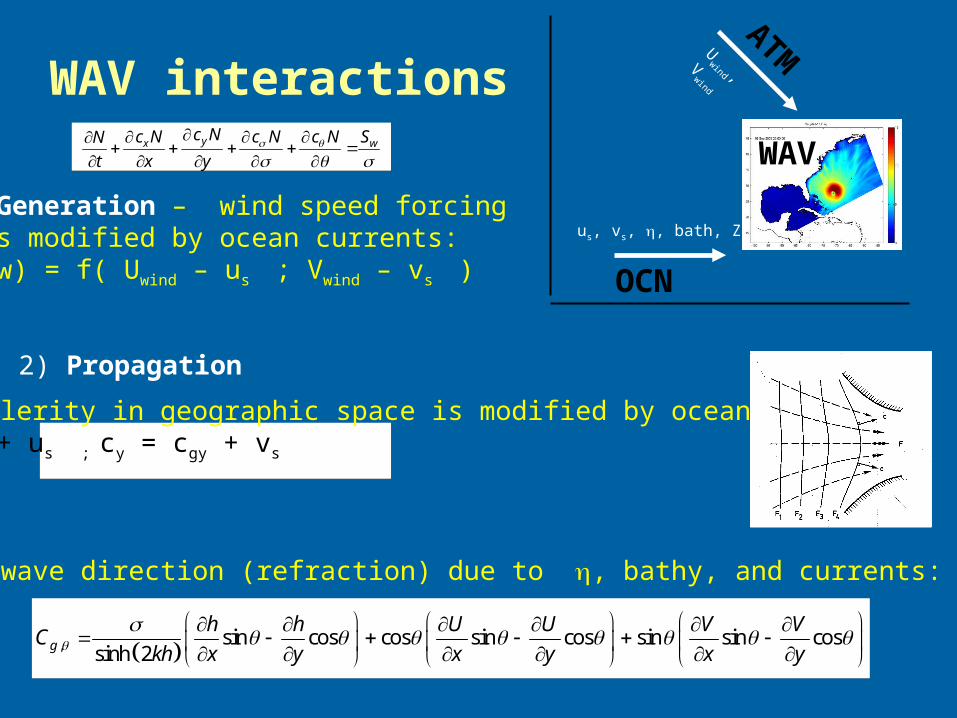
SWANyx w
c Nc N c N c N SN
t x y
cx, cy = propagation velocities (x- and y- directions) = relative frequency = wave direction
S = source/sink term for: - wind-wave generation - wave breaking - bottom dissipation - nonlinear wave-wave interactions
SWAN accounts for shoaling, diffraction, partial transmission, and reflection.
N = wave action density (energy density / relative frequency)
Booij, N., R.C. Ris and L.H. Holthuijsen, 1999, A third-generation wave model for coastal regions, Part I, Model description and validation, J.Geoph.Research, 104, C4, 7649-7666.Booij, N., R.C. Ris and L.H. Holthuijsen, 1999, A third-generation wave model for coastal regions, Part II, Model description and validation, J.Geoph.Research, 104, C4, 7649-7666.Booij, N., Haagsma, IJ.G., Holthuijsen, L.H., Kieftenburg, A.T.M.M., Ris, R.C., van der Westhuysen, A.J., and Zijlema, M. (2004). SWAN Cycle III version 40.41 User Manual, Delft University of Technology.
Input file - to run SWAN by itselfSWAN is driven by a
series of 'KEYWORDS' in the
input file.
'PROJECT''MODE'
'SET''CGRID'
'READGRID'
etcetc
Projects/Inlet_Test/Swanonly/swan_inlet_test.in
Keywords: Start-up
Keywords: model description
Keywords: model description
Keywords: Output and Run
Input file - control commandsPROJECT - 4 text lines
SET - DEPMIN to be same as Dcrit - INRHOG 1 !!!!!! - NAUTICAL !!!!
COORDINATES - SPHERICAL or CARTESIAN
MODE NONSTAT TWOD
Input file - computational gridCGRID and READGRID: Defines the computational grid in x, y, freq, and theta space.
Input file - input gridsINPGRID and READINP: Input grid for variables of bottom, waterlevel, currents, winds, etc.
This is for the BOTTOM (bathymetry)
Input file - to run SWAN by itselfINPGRID and READINP: Input grid for variables of bottom, waterlevel, currents, winds, etc.
This is an example for WIND
We typically use IDLA = 4
Input file - Boundary inputsBOUND SHAPEBOUND SIDE or BOUND SEGMENT
Input file - Boundary inputsBOUND SHAPEBOUND SIDE or BOUND SEGMENT
THIS command uses I J indices along a segment
Input file - Boundary inputsBOUND SHAPEBOUND SIDE or BOUND SEGMENT
THIS command uses X Y indices along a segmentwith input files
TPAR file
Lists the date, Hsig, Period, Direction, and Spreading factor
Input file - Init files
Can start SWAN with data from an init file.This file can be created from a STATIONARY run.
Input file - Physics
Input file - Output and run
start dt end
Can make this as STATIONARY, then don’t need start:dt:endto get init conditions files.
How to create a SWAN application
1) cppdefs.h 2) grids 3) wind forcing 4) boundary conditions 5) INPUT 6) coawst.bash 7) run it
1) cppdefs.h
just do SWAN MODEL for now
will ad refined grid later
2) gridscreate_roms_xy_grid
1) you can use the CGRID Regular command
or
2) create a ROMS grid using any of the tools mentioned before, then runroms2swan(x, y, depth, mask)
for example, the bottom of the create_roms_xy_gridcalls to roms2swan. This creates 2 files:
grid_coord.grd (goes with READGRID COORDS)swan_bathy.bot (goes with READINP BOTTOM)
3) wind forcingCan use Tools\mfiles\mtools\narr2romsnc.mAt the end of this file, it creates the wind forcing file for SWAN.Need to add this wind file name to READINP WIND.
4) boundary conditions - TPAR
Can use Tools\mfiles\swan_forc\ww3_swan_input.mTo read WW3 model output and create SWAN TPAR boundary forcing files.
5) INPUT
Projects/Inlet_Test/Swanonly/swan_inlet_test.in
6) coawst.bash7) run it
Build it by setting the Project name and paths in the coawst.bash.
Run it by call to coawstM, but now need to explicitly state input file name
SURFACE ROUGHNESS CLOSURE MODELSCurrently only in MYJSFC and MYNN
TAYLOR & YELLAND 2001: TY2001 (#define COARE_TAYLOR_YELLAND)
DRENNAN 2003: DGQH (#define DRENNAN)
OOST 2002: OOST (#define COARE_OOST)
4.50 1200ms p
s
zH L
H
- Wave steepness based parameterization.- Based on three datasets representing sea-state conditions ranging from strongly forced to shoaling.
3.40*3.35m
ps
zu C
H
4.50*
25.0mp
p
zu C
L
- Wave age dependent formula but it also considers the effect of the wave steepness.
- Wave age based formula to characterize the ocean roughness. - They combined data from many field experiments representing a variety of condition and grouped the data as a function of the wind friction velocity.