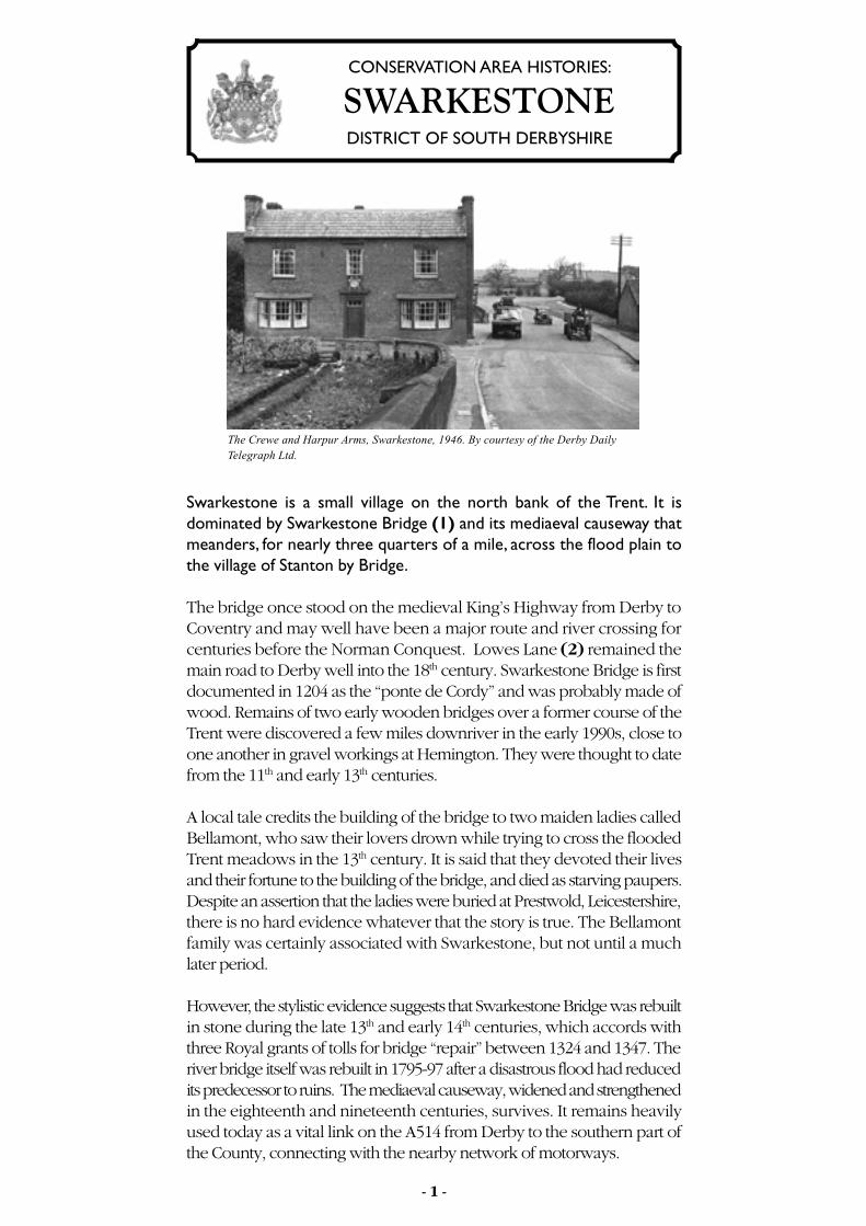
Swarkestone is a small village on the north bank of the Trent. It is dominated by Swarkestone Bridge (1) and its mediaeval causeway that meanders, for nearly three quarters of a mile, across the flood plain to the village of Stanton by Bridge. The bridge once stood on the medieval King’s Highway from Derby to Coventry and may well have been a major route and river crossing for centuries before the Norman Conquest. Lowes Lane (2) remained the main road to Derby well into the 18 th century. Swarkestone Bridge is first documented in 1204 as the “ponte de Cordy” and was probably made of wood. Remains of two early wooden bridges over a former course of the Trent were discovered a few miles downriver in the early 1990s, close to one another in gravel workings at Hemington. They were thought to date from the 11 th and early 13 th centuries. A local tale credits the building of the bridge to two maiden ladies called Bellamont, who saw their lovers drown while trying to cross the flooded Trent meadows in the 13 th century. It is said that they devoted their lives and their fortune to the building of the bridge, and died as starving paupers. Despite an assertion that the ladies were buried at Prestwold, Leicestershire, there is no hard evidence whatever that the story is true. The Bellamont family was certainly associated with Swarkestone, but not until a much later period. However, the stylistic evidence suggests that Swarkestone Bridge was rebuilt in stone during the late 13 th and early 14 th centuries, which accords with three Royal grants of tolls for bridge “repair” between 1324 and 1347. The river bridge itself was rebuilt in 1795-97 after a disastrous flood had reduced its predecessor to ruins. The mediaeval causeway, widened and strengthened in the eighteenth and nineteenth centuries, survives. It remains heavily used today as a vital link on the A514 from Derby to the southern part of the County, connecting with the nearby network of motorways. The Crewe and Harpur Arms, Swarkestone, 1946. By courtesy of the Derby Daily Telegraph Ltd. - 1 - SWARKESTONE CONSERVATION AREA HISTORIES: DISTRICT OF SOUTH DERBYSHIRE
Transcript
Swarkestone takes its name from a Dane called Swerkir who, it is surmised,was granted land in the aftermath of the Danish occupation of Repton in874. Swerkir may have been posted here to defend an important route, orperhaps the land was simply a reward for services rendered. Swarkestone’sstrategic importance has subsequently been marked by a minor battlebetween Roundheads and Cavaliers in January 1643, and the Bridge hasachieved some notoriety as the place where the advance guard of BonniePrince Charlie’s Army finally turned back to Scotland in 1745. Even duringthe Second World War it was defended by gun emplacements and tanktraps against the threat of a German invasion.
More properly called Swarkeston (a nineteenth century vicar added anextra flourish to the name of his parish - and it stuck), the suffix “ton”indicates that it was an Anglo Saxon settlement long before the Danes.Indeed there is ample archaeological evidence on the river terraces abovethe village to show that there has been human activity and settlement inSwarkestone since the arrival of the “Beaker People” in the early BronzeAge (2600-1600BC) at least. Collectively known as Swarkestone Lowes,five or six tumuli (3) dominated the skyline to the east of Lowes Lane untilmost were ploughed out in the 20th century. Only one now remains inanything like its former glory, lying by the road to Lowes Farm. Some ofthe tumuli were reused as burial places by early Anglian settlers in the fifthor sixth centuries, and an exercise track for horses (4, 4) took a circuitround them in the eighteenth century.
Slightly to the north west of Lowes Farm is the site of both an Iron Ageand Romano British settlement (800BC – 500AD),while aerial photographsshowing crop marks suggest that there was some sort of settlement belowthe farm on both sides of the road to Barrow. The name “Russewijk”,which gave its name to a furlong in one of the old common fields ofSwarkestone, may signify a Dark Age farmstead. It lay near the road toWeston on Trent and the neighbouring stretch of the Trent and MerseyCanal.
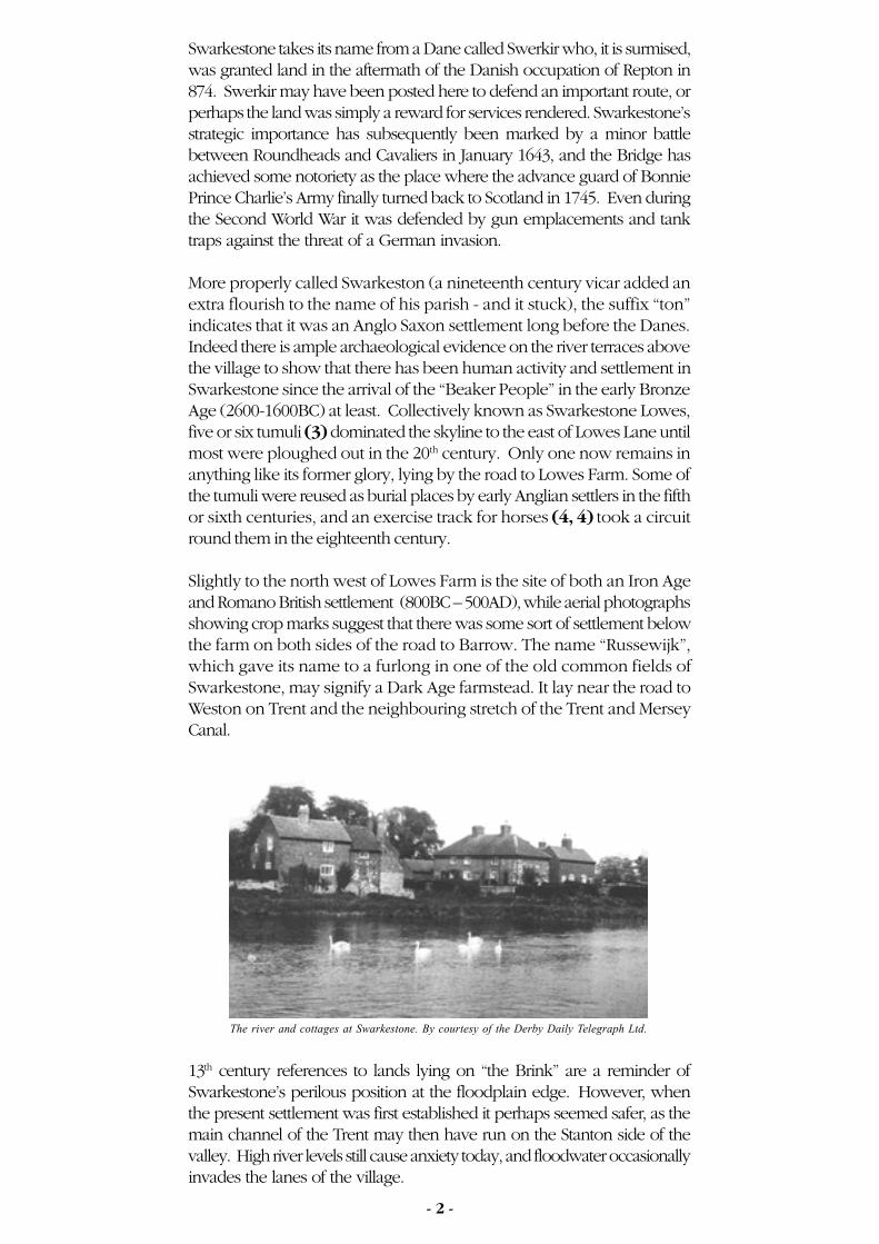
13th century references to lands lying on “the Brink” are a reminder ofSwarkestone’s perilous position at the floodplain edge. However, whenthe present settlement was first established it perhaps seemed safer, as themain channel of the Trent may then have run on the Stanton side of thevalley. High river levels still cause anxiety today, and floodwater occasionallyinvades the lanes of the village.
course of sweetmeats, fruit and wine, and to admire the view from therooftop. The accommodation included a cellar. Puddings apart, it was usedfrom its inception as a place for card and dice games where considerableamounts of money changed hands!
The Bowl Alley House is built in the style of John Smythson (d1643), whowas partly responsible for the rebuilding of William Cavendish’s fairytalecastle at Bolsover, but there is no evidence that Smythson was directlyinvolved at Swarkestone. The “surveyor” (as architects of the day wereknown) at Swarkestone is named as a Mr Wooldridge, perhaps an associateof the Smythsons. The building was constructed by Richard Shepherd for£111 12s 4d, with extra being paid for the lead for the domes.
The Bowl Alley House was abandoned when the Hall fell out of use, butcare was taken to preserve the masonry shell as a folly, or as a symbol offamily pride and history. Sir Henry Crewe of Calke (1763-1819) clearlyvisited Swarkestone from time to time, as he had a boathouse there andbuilt a short-lived “casina” or fishing lodge near it in 1809 (10). In morerecent times the Rolling Stones have famously posed in front of BowlAlley House for a record sleeve, and in the early 1980s it was lovinglyrestored by the Landmark Trust for use as an unconventional holiday home.
Nearby lies the “Tithe Barn”, now a house (11), and dating from thesixteenth or early seventeenth century. It is unlikely, considering its sizeand original features, to have ever been a tithe barn. In the nineteenthcentury it was “the stables” and was possibly used as such from the start.Its gardens back onto the presumed site of the Elizabethan Hall and anarrangement of brick and stone walled enclosures that once housed gardens.The gravelled paths of a formal garden have been recorded in one ofthem (7) and the bricks were almost certainly made in the nearby BrickilnClose which is recorded c1585.
Old Hall Farm itself is, as yet, a bit of a mystery (12). Its style and detailing,with mullioned windows, suggest a date in the first half of the seventeenthcentury, but its site is curious, given that the Old Hall itself was so near andwas still standing then. The house was extended in the nineteenth centuryand a fine “new model farmyard” of c1840 stands nearby.
the last Sir John Harpur of Swarkestone (d1679) amounts to a postscript onthe florid monument to his second wife, the much-married Lady FrancesWilloughby.
During the 16th and early 17th centuries Richard Harpur and his son SirJohn amassed, between them, vast tracts of land in South Derbyshire andStaffordshire. Until 1679 and the absence of a direct male heir, Swarkestonewas the principal family seat. In the 1620s Swarkestone Hall was a fineElizabethan country house (7) boasting a gatehouse, some 45 rooms, awine cellar and a dovecote.
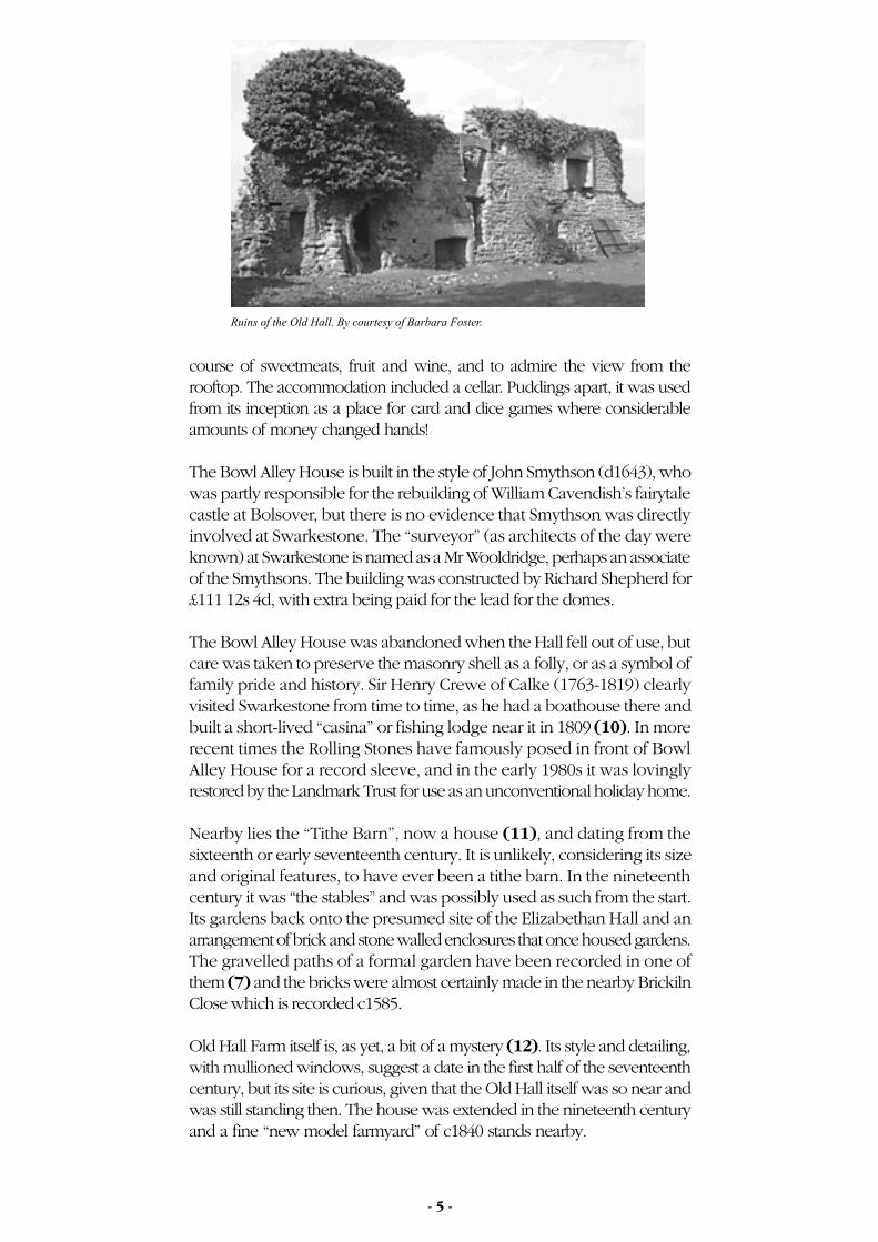
The house was damaged during the Civil War but repaired afterwards. Itappears to have been little used after c1715 and was pulled down duringthe first half of the 18th century. Thereafter Calke Abbey became the hubof the Harpur estates and Swarkestone’s importance declined. Some ruinsof Swarkestone Hall yet remain in the grounds of Old Hall Farm. Theysuggest that an older house (perhaps that of the Rollestons) wasincorporated into Richard Harpur’s splendid new one. Other fragments,together with the evidence of aerial photography, suggest that the OldHall lay in and around the close adjacent to the ruins and towards the BowlAlley House (8). An impressive pair of stone gate piers survives by themain road (9).
Bowl Alley House, also known variously as the Balcony, Pavilion, Stand, orBanqueting House, was completed in 1632 and rivals the bridge asSwarkestone’s best known landmark. It was built just in time for the comingof age and marriage of John Harpur of Breadsall who, as an 11 year boy,became heir to the estate in 1622 - a singularly tragic year for the Harpurs.Two heirs died in succession that year, along with “Old Sir John” himself.Young Sir John survived a fractious wardship to marry Catherine Howard,granddaughter of the Earl of Suffolk and stepdaughter of WilliamCavendish, later the 1st Duke of Newcastle. Sir John entered his inheritancein 1632. It seems probable, therefore, that the Bowl Alley House - anarchitectural confection if ever there was one – was built to celebrate thesetwin events.
The building takes its name from the close in which it was built, but it wasindeed a banqueting house built at the very height of their fashion. It wasa pavilion to retire to after feasts, for conversation, for enjoying a dessert
By 1086 Swarkestone was already a well-established community with a longhistory. The Domesday survey shows that King William held the sameland that had been held by King Edward the Confessor and described as aberewick of Melbourne, whilst Henry de Ferrers was rewarded with theland of four freemen. This division of land is reflected in deeds anddocuments of Swarkestone until 1632, when the Harpur family finallybought out the last freeholder. The village and parish were thus unitedinto a single ownership that survived, largely intact, until sales by the HarpurCrewe estate during the 1980s.
Geoffrey de Bec is the first recorded Lord of the Manor in 1215. Hisname appears in a document transferring the advowson (the right to appointa clergyman) of the church in Swarkestone from the Knights Hospitallersat Barrow to the de Bec family. The advowson still nominally lay with theHarpur Crewe family as Lords of the Manor until the last year of the 20th
century.
The Church (5) was possibly built as a daughter chapel for the KnightsHospitallers in the mid 12th century, or some years earlier by a manoriallord. It certainly boasted a chevron ornamented chancel arch and atympanum carved “with monstrous quadrupeds”, both Norman, but allthis was lost when the church was rebuilt in 1876. However, the HarpurChapel built before 1577 remains little altered, as does the 14th centurytower save for the loss of its corner pinnacles. The rest of the church isnow an exercise in Victorian Gothic, designed by F.J. Robinson.
Opposite the church lies a small house of the early 19th century, laterconverted for use as a parish room (6). Used for vestry meetings, parishevents and in between times as a “reading room”, it became a privatehouse in the late 1970s.
In the mid fourteenth century the Rolleston family became the Lords ofthe Manor and remained so for 200 years until Richard Harpur, a Serjeantat Law, bought their land in 1557. A fine Chellaston alabaster tomb toJohn Rolleston who died in 1482 survives in the church, as do the grandmonuments to Richard Harpur (Judge at the Court of Common Pleasd1577), his son Sir John Harpur (d1622) and their wives. The memorial to
Swarkestone is a small village on the north bank of the Trent. It isdominated by Swarkestone Bridge (1) and its mediaeval causeway thatmeanders, for nearly three quarters of a mile, across the flood plain tothe village of Stanton by Bridge.
The bridge once stood on the medieval King’s Highway from Derby toCoventry and may well have been a major route and river crossing forcenturies before the Norman Conquest. Lowes Lane (2) remained themain road to Derby well into the 18th century. Swarkestone Bridge is firstdocumented in 1204 as the “ponte de Cordy” and was probably made ofwood. Remains of two early wooden bridges over a former course of theTrent were discovered a few miles downriver in the early 1990s, close toone another in gravel workings at Hemington. They were thought to datefrom the 11th and early 13th centuries.
A local tale credits the building of the bridge to two maiden ladies calledBellamont, who saw their lovers drown while trying to cross the floodedTrent meadows in the 13th century. It is said that they devoted their livesand their fortune to the building of the bridge, and died as starving paupers.Despite an assertion that the ladies were buried at Prestwold, Leicestershire,there is no hard evidence whatever that the story is true. The Bellamontfamily was certainly associated with Swarkestone, but not until a muchlater period.
However, the stylistic evidence suggests that Swarkestone Bridge was rebuiltin stone during the late 13th and early 14th centuries, which accords withthree Royal grants of tolls for bridge “repair” between 1324 and 1347. Theriver bridge itself was rebuilt in 1795-97 after a disastrous flood had reducedits predecessor to ruins. The mediaeval causeway, widened and strengthenedin the eighteenth and nineteenth centuries, survives. It remains heavilyused today as a vital link on the A514 from Derby to the southern part ofthe County, connecting with the nearby network of motorways.
The river and cottages at Swarkestone. By courtesy of the Derby Daily Telegraph Ltd.
Ruins of the Old Hall. By courtesy of Barbara Foster.
The Crewe and Harpur Arms, Swarkestone, 1946. By courtesy of the Derby DailyTelegraph Ltd.
- 1 - - 2 - - 3 - - 4 - - 5 -
SWARKESTONE
Old Hall Farm. By courtesy of Barbara Foster.
CONSERVATION AREA HISTORIES:
DISTRICT OF SOUTH DERBYSHIRE
The Swarkestone Pavilion. SDDC Collection.
Swarkestone 23/3/05, 4:31 PM1
Swarkestone takes its name from a Dane called Swerkir who, it is surmised,was granted land in the aftermath of the Danish occupation of Repton in874. Swerkir may have been posted here to defend an important route, orperhaps the land was simply a reward for services rendered. Swarkestone’sstrategic importance has subsequently been marked by a minor battlebetween Roundheads and Cavaliers in January 1643, and the Bridge hasachieved some notoriety as the place where the advance guard of BonniePrince Charlie’s Army finally turned back to Scotland in 1745. Even duringthe Second World War it was defended by gun emplacements and tanktraps against the threat of a German invasion.
More properly called Swarkeston (a nineteenth century vicar added anextra flourish to the name of his parish - and it stuck), the suffix “ton”indicates that it was an Anglo Saxon settlement long before the Danes.Indeed there is ample archaeological evidence on the river terraces abovethe village to show that there has been human activity and settlement inSwarkestone since the arrival of the “Beaker People” in the early BronzeAge (2600-1600BC) at least. Collectively known as Swarkestone Lowes,five or six tumuli (3) dominated the skyline to the east of Lowes Lane untilmost were ploughed out in the 20th century. Only one now remains inanything like its former glory, lying by the road to Lowes Farm. Some ofthe tumuli were reused as burial places by early Anglian settlers in the fifthor sixth centuries, and an exercise track for horses (4, 4) took a circuitround them in the eighteenth century.
Slightly to the north west of Lowes Farm is the site of both an Iron Ageand Romano British settlement (800BC – 500AD),while aerial photographsshowing crop marks suggest that there was some sort of settlement belowthe farm on both sides of the road to Barrow. The name “Russewijk”,which gave its name to a furlong in one of the old common fields ofSwarkestone, may signify a Dark Age farmstead. It lay near the road toWeston on Trent and the neighbouring stretch of the Trent and MerseyCanal.
13th century references to lands lying on “the Brink” are a reminder ofSwarkestone’s perilous position at the floodplain edge. However, whenthe present settlement was first established it perhaps seemed safer, as themain channel of the Trent may then have run on the Stanton side of thevalley. High river levels still cause anxiety today, and floodwater occasionallyinvades the lanes of the village.
course of sweetmeats, fruit and wine, and to admire the view from therooftop. The accommodation included a cellar. Puddings apart, it was usedfrom its inception as a place for card and dice games where considerableamounts of money changed hands!
The Bowl Alley House is built in the style of John Smythson (d1643), whowas partly responsible for the rebuilding of William Cavendish’s fairytalecastle at Bolsover, but there is no evidence that Smythson was directlyinvolved at Swarkestone. The “surveyor” (as architects of the day wereknown) at Swarkestone is named as a Mr Wooldridge, perhaps an associateof the Smythsons. The building was constructed by Richard Shepherd for£111 12s 4d, with extra being paid for the lead for the domes.
The Bowl Alley House was abandoned when the Hall fell out of use, butcare was taken to preserve the masonry shell as a folly, or as a symbol offamily pride and history. Sir Henry Crewe of Calke (1763-1819) clearlyvisited Swarkestone from time to time, as he had a boathouse there andbuilt a short-lived “casina” or fishing lodge near it in 1809 (10). In morerecent times the Rolling Stones have famously posed in front of BowlAlley House for a record sleeve, and in the early 1980s it was lovinglyrestored by the Landmark Trust for use as an unconventional holiday home.
Nearby lies the “Tithe Barn”, now a house (11), and dating from thesixteenth or early seventeenth century. It is unlikely, considering its sizeand original features, to have ever been a tithe barn. In the nineteenthcentury it was “the stables” and was possibly used as such from the start.Its gardens back onto the presumed site of the Elizabethan Hall and anarrangement of brick and stone walled enclosures that once housed gardens.The gravelled paths of a formal garden have been recorded in one ofthem (7) and the bricks were almost certainly made in the nearby BrickilnClose which is recorded c1585.
Old Hall Farm itself is, as yet, a bit of a mystery (12). Its style and detailing,with mullioned windows, suggest a date in the first half of the seventeenthcentury, but its site is curious, given that the Old Hall itself was so near andwas still standing then. The house was extended in the nineteenth centuryand a fine “new model farmyard” of c1840 stands nearby.
the last Sir John Harpur of Swarkestone (d1679) amounts to a postscript onthe florid monument to his second wife, the much-married Lady FrancesWilloughby.
During the 16th and early 17th centuries Richard Harpur and his son SirJohn amassed, between them, vast tracts of land in South Derbyshire andStaffordshire. Until 1679 and the absence of a direct male heir, Swarkestonewas the principal family seat. In the 1620s Swarkestone Hall was a fineElizabethan country house (7) boasting a gatehouse, some 45 rooms, awine cellar and a dovecote.
The house was damaged during the Civil War but repaired afterwards. Itappears to have been little used after c1715 and was pulled down duringthe first half of the 18th century. Thereafter Calke Abbey became the hubof the Harpur estates and Swarkestone’s importance declined. Some ruinsof Swarkestone Hall yet remain in the grounds of Old Hall Farm. Theysuggest that an older house (perhaps that of the Rollestons) wasincorporated into Richard Harpur’s splendid new one. Other fragments,together with the evidence of aerial photography, suggest that the OldHall lay in and around the close adjacent to the ruins and towards the BowlAlley House (8). An impressive pair of stone gate piers survives by themain road (9).
Bowl Alley House, also known variously as the Balcony, Pavilion, Stand, orBanqueting House, was completed in 1632 and rivals the bridge asSwarkestone’s best known landmark. It was built just in time for the comingof age and marriage of John Harpur of Breadsall who, as an 11 year boy,became heir to the estate in 1622 - a singularly tragic year for the Harpurs.Two heirs died in succession that year, along with “Old Sir John” himself.Young Sir John survived a fractious wardship to marry Catherine Howard,granddaughter of the Earl of Suffolk and stepdaughter of WilliamCavendish, later the 1st Duke of Newcastle. Sir John entered his inheritancein 1632. It seems probable, therefore, that the Bowl Alley House - anarchitectural confection if ever there was one – was built to celebrate thesetwin events.
The building takes its name from the close in which it was built, but it wasindeed a banqueting house built at the very height of their fashion. It wasa pavilion to retire to after feasts, for conversation, for enjoying a dessert
By 1086 Swarkestone was already a well-established community with a longhistory. The Domesday survey shows that King William held the sameland that had been held by King Edward the Confessor and described as aberewick of Melbourne, whilst Henry de Ferrers was rewarded with theland of four freemen. This division of land is reflected in deeds anddocuments of Swarkestone until 1632, when the Harpur family finallybought out the last freeholder. The village and parish were thus unitedinto a single ownership that survived, largely intact, until sales by the HarpurCrewe estate during the 1980s.
Geoffrey de Bec is the first recorded Lord of the Manor in 1215. Hisname appears in a document transferring the advowson (the right to appointa clergyman) of the church in Swarkestone from the Knights Hospitallersat Barrow to the de Bec family. The advowson still nominally lay with theHarpur Crewe family as Lords of the Manor until the last year of the 20th
century.
The Church (5) was possibly built as a daughter chapel for the KnightsHospitallers in the mid 12th century, or some years earlier by a manoriallord. It certainly boasted a chevron ornamented chancel arch and atympanum carved “with monstrous quadrupeds”, both Norman, but allthis was lost when the church was rebuilt in 1876. However, the HarpurChapel built before 1577 remains little altered, as does the 14th centurytower save for the loss of its corner pinnacles. The rest of the church isnow an exercise in Victorian Gothic, designed by F.J. Robinson.
Opposite the church lies a small house of the early 19th century, laterconverted for use as a parish room (6). Used for vestry meetings, parishevents and in between times as a “reading room”, it became a privatehouse in the late 1970s.
In the mid fourteenth century the Rolleston family became the Lords ofthe Manor and remained so for 200 years until Richard Harpur, a Serjeantat Law, bought their land in 1557. A fine Chellaston alabaster tomb toJohn Rolleston who died in 1482 survives in the church, as do the grandmonuments to Richard Harpur (Judge at the Court of Common Pleasd1577), his son Sir John Harpur (d1622) and their wives. The memorial to
Swarkestone is a small village on the north bank of the Trent. It isdominated by Swarkestone Bridge (1) and its mediaeval causeway thatmeanders, for nearly three quarters of a mile, across the flood plain tothe village of Stanton by Bridge.
The bridge once stood on the medieval King’s Highway from Derby toCoventry and may well have been a major route and river crossing forcenturies before the Norman Conquest. Lowes Lane (2) remained themain road to Derby well into the 18th century. Swarkestone Bridge is firstdocumented in 1204 as the “ponte de Cordy” and was probably made ofwood. Remains of two early wooden bridges over a former course of theTrent were discovered a few miles downriver in the early 1990s, close toone another in gravel workings at Hemington. They were thought to datefrom the 11th and early 13th centuries.
A local tale credits the building of the bridge to two maiden ladies calledBellamont, who saw their lovers drown while trying to cross the floodedTrent meadows in the 13th century. It is said that they devoted their livesand their fortune to the building of the bridge, and died as starving paupers.Despite an assertion that the ladies were buried at Prestwold, Leicestershire,there is no hard evidence whatever that the story is true. The Bellamontfamily was certainly associated with Swarkestone, but not until a muchlater period.
However, the stylistic evidence suggests that Swarkestone Bridge was rebuiltin stone during the late 13th and early 14th centuries, which accords withthree Royal grants of tolls for bridge “repair” between 1324 and 1347. Theriver bridge itself was rebuilt in 1795-97 after a disastrous flood had reducedits predecessor to ruins. The mediaeval causeway, widened and strengthenedin the eighteenth and nineteenth centuries, survives. It remains heavilyused today as a vital link on the A514 from Derby to the southern part ofthe County, connecting with the nearby network of motorways.
The river and cottages at Swarkestone. By courtesy of the Derby Daily Telegraph Ltd.
Ruins of the Old Hall. By courtesy of Barbara Foster.
The Crewe and Harpur Arms, Swarkestone, 1946. By courtesy of the Derby DailyTelegraph Ltd.
- 1 - - 2 - - 3 - - 4 - - 5 -
SWARKESTONE
Old Hall Farm. By courtesy of Barbara Foster.
CONSERVATION AREA HISTORIES:
DISTRICT OF SOUTH DERBYSHIRE
The Swarkestone Pavilion. SDDC Collection.
Swarkestone 23/3/05, 4:31 PM1
Bridge House across the road (22) was built around the same time althoughthere are indications that the rear section of the house is somewhat earlierand built on even older foundations. An alehouse known as “The Gate” atthe junction of Barrow Lane (23) served for many years as a watering holefor the canal users.
Touched by major national events and innovations throughout its history,its landscape carved through by canals, railways and roads and its farmerslargely gone, Swarkestone nevertheless remains the small village it was inthe twelfth century. Remarkably, in size and configuration the village hasscarcely changed since the sixteenth century and for many of the peopleof Derby, the parish boundary on the brow of Chellaston Hill now marksthe place where the countryside begins.
Barbara Foster.
Designed and published by South Derbyshire District Council.March 2005. Series editor: Philip Heath. The views and opinions expressedare those of the author(s) concerned and do not necessarily reflect theviews of the District Council.
If you require a copy of this information in another language,braille or large print format please contact the CustomerServices Manager on 01283 595784.
Agriculture was the main activity of the village until relativelyrecently. Half of the land was enclosed by 1632 and the commonfields were finally enclosed in 1777. There is however evidence ofa cottage weaving industry, a stone mason’s yard (?13) and largescale maltings (?14) in the eighteenth century. Swarkestone brieflyboasted its own school in 1649. Shoemakers flourished from theseventeenth to the nineteenth century, and there was the usualcomplement of butchers and bakers. The blacksmith perhaps turnedhis hand to candlestick making! On each side of the bridge, on theSwarkestone bank of the river, there were wharves associated with the“raff” or timber trade, which no doubt gave Woodshop Lane its name. Itwas floating timber, pinned against the river bridge by the current, thatdestroyed the old bridge in 1795. Another wharf at Cuttle Bridge on theTrent and Mersey Canal (15) served the plaster pits at Chellaston from the1780s, and resulted in a realignment of what is now the main road toChellaston and Derby.
The Trent and Mersey was completed through Swarkestone in 1777 and ashort-lived link from the River Trent to the Derby canal and the Trent andMersey canal was dug in 1795 (16, 16). It was built by the Derby CanalCompany to serve the South Derbyshire coal measures, as part of aproposed network of canals south of the river. In the event these werenever built. The link closed in the 1820s as a result of lack of trade andpunitive charges by the Trent and Mersey Canal Company (for the use ofboth its water and a short length of its course). The best remaining evidenceof it is the entrance from the Trent, just over the wall of the Crewe andHarpur garden.
The picturesque black and white timbered frontage of the “CrowsNest” on Woodshop Lane (17) may date from the early seventeenthcentury, but its use as a dairy in the 1920s and 30s has meant thatnot much else has survived. It is now a private house. Elsewhere inthe village there is some evidence of ancient timber framed buildingsthat survived a disastrous fire in 1654. Less spectacular than thefrontage of the Crows Nest, roof trusses at Hollies Farm (18) onthe banks of the Trent probably predate both the fire and theinsertion of a flue before the 1630s. Other timber framed coressurvive elsewhere, but much of the village housing dates from a“great rebuilding” in the nineteeth century.
Lowes Farm includes a handsome farmhouse (19), originally built as racingstables by Sir Harry Harpur (1739-1789) in 1777. An exercise course waslaid out nearby (4, 4), which shows clearly on the Swarkestone parish planof 1844, and races were held on Sinfin Moor. Soon after Sir Harry’s death,the stables at the Lowes were converted into a house, which has recentlybeen divided into apartments.
An inn, known by “the sign of the Talbot”, could be found at Swarkestonein the mid sixteenth century. Its site is unknown, but rentals and QuarterSessions records suggest that it may have stood by the river bridge on theStanton side (20). Certainly an Inn stood there in the 1680s, if not before,marked as a chapel on OS maps. It was superseded by the Crewe andHarpur Arms (21) which, together with its fine stable block, was built in thelate eighteenth century in anticipation of the turnpiking of the road toAshby. In the event this never happened, but huntsmen and cockfightersalike gathered in its forecourt for a bit of sport in the nineteenth century. Map reproduced with the permission of the Landmark Information Group (c) Crown copyright and Landmark Information Group Ltd (All Rights Reserved 2005). Conservation Area outlined in black.
The River Bridge (1795-97). SDDC collection.
- 6 - - 7 -
ORDNANCE SURVEY 25”, REVISED 1899
CONSERVATION AREA DESIGNATED 23/11/1977
SWARKESTONENB: Swarkestone Bridge is part of the Stanton Conservation Area.
Swarkestone 23/3/05, 4:32 PM2
Bridge House across the road (22) was built around the same time althoughthere are indications that the rear section of the house is somewhat earlierand built on even older foundations. An alehouse known as “The Gate” atthe junction of Barrow Lane (23) served for many years as a watering holefor the canal users.
Touched by major national events and innovations throughout its history,its landscape carved through by canals, railways and roads and its farmerslargely gone, Swarkestone nevertheless remains the small village it was inthe twelfth century. Remarkably, in size and configuration the village hasscarcely changed since the sixteenth century and for many of the peopleof Derby, the parish boundary on the brow of Chellaston Hill now marksthe place where the countryside begins.
Barbara Foster.
Designed and published by South Derbyshire District Council.March 2005. Series editor: Philip Heath. The views and opinions expressedare those of the author(s) concerned and do not necessarily reflect theviews of the District Council.
If you require a copy of this information in another language,braille or large print format please contact the CustomerServices Manager on 01283 595784.
Agriculture was the main activity of the village until relativelyrecently. Half of the land was enclosed by 1632 and the commonfields were finally enclosed in 1777. There is however evidence ofa cottage weaving industry, a stone mason’s yard (?13) and largescale maltings (?14) in the eighteenth century. Swarkestone brieflyboasted its own school in 1649. Shoemakers flourished from theseventeenth to the nineteenth century, and there was the usualcomplement of butchers and bakers. The blacksmith perhaps turnedhis hand to candlestick making! On each side of the bridge, on theSwarkestone bank of the river, there were wharves associated with the“raff” or timber trade, which no doubt gave Woodshop Lane its name. Itwas floating timber, pinned against the river bridge by the current, thatdestroyed the old bridge in 1795. Another wharf at Cuttle Bridge on theTrent and Mersey Canal (15) served the plaster pits at Chellaston from the1780s, and resulted in a realignment of what is now the main road toChellaston and Derby.
The Trent and Mersey was completed through Swarkestone in 1777 and ashort-lived link from the River Trent to the Derby canal and the Trent andMersey canal was dug in 1795 (16, 16). It was built by the Derby CanalCompany to serve the South Derbyshire coal measures, as part of aproposed network of canals south of the river. In the event these werenever built. The link closed in the 1820s as a result of lack of trade andpunitive charges by the Trent and Mersey Canal Company (for the use ofboth its water and a short length of its course). The best remaining evidenceof it is the entrance from the Trent, just over the wall of the Crewe andHarpur garden.
The picturesque black and white timbered frontage of the “CrowsNest” on Woodshop Lane (17) may date from the early seventeenthcentury, but its use as a dairy in the 1920s and 30s has meant thatnot much else has survived. It is now a private house. Elsewhere inthe village there is some evidence of ancient timber framed buildingsthat survived a disastrous fire in 1654. Less spectacular than thefrontage of the Crows Nest, roof trusses at Hollies Farm (18) onthe banks of the Trent probably predate both the fire and theinsertion of a flue before the 1630s. Other timber framed coressurvive elsewhere, but much of the village housing dates from a“great rebuilding” in the nineteeth century.
Lowes Farm includes a handsome farmhouse (19), originally built as racingstables by Sir Harry Harpur (1739-1789) in 1777. An exercise course waslaid out nearby (4, 4), which shows clearly on the Swarkestone parish planof 1844, and races were held on Sinfin Moor. Soon after Sir Harry’s death,the stables at the Lowes were converted into a house, which has recentlybeen divided into apartments.
An inn, known by “the sign of the Talbot”, could be found at Swarkestonein the mid sixteenth century. Its site is unknown, but rentals and QuarterSessions records suggest that it may have stood by the river bridge on theStanton side (20). Certainly an Inn stood there in the 1680s, if not before,marked as a chapel on OS maps. It was superseded by the Crewe andHarpur Arms (21) which, together with its fine stable block, was built in thelate eighteenth century in anticipation of the turnpiking of the road toAshby. In the event this never happened, but huntsmen and cockfightersalike gathered in its forecourt for a bit of sport in the nineteenth century. Map reproduced with the permission of the Landmark Information Group (c) Crown copyright and Landmark Information Group Ltd (All Rights Reserved 2005). Conservation Area outlined in black.
The River Bridge (1795-97). SDDC collection.
- 6 - - 7 -
ORDNANCE SURVEY 25”, REVISED 1899
CONSERVATION AREA DESIGNATED 23/11/1977
SWARKESTONENB: Swarkestone Bridge is part of the Stanton Conservation Area.