Technical Report No. 99-02 SYNTHESIS OF EXISTING INFORMATION Volume 1: A CHAR,iCTERIL1TJON OF WATER QUA.LITY, HYDROLOGIC ALTERATIONS, AND FiSH :lSD H1LDLI FE H/iBI1AT IN THE GRE/! TER CHARLOTTE HARBOR HATERSHED Buteo lineatus Red-shouldered" Hawk N Peace River & Watershed * Myakka River & Watershed Coastal Venice/Lemon Bay/Gasparilla Sound/Cape Haze Charlotte Harbor Proper u Pine Island Sound/Matlacha Pass · Estero Bay & Watershed 0 Tidal Caloosahatchee River & Watershed ·1 1
Transcript
Technical Report No. 99-02
SYNTHESIS OFEXISTING INFORMATION
Volume 1:A CHAR,iCTERIL1TJON OF WATER QUA.LITY, HYDROLOGIC ALTERATIONS, AND
FiSH :lSD H1LDLIFE H/iBI1AT IN THE GRE/! TER CHARLOTTE HARBOR HATERSHED
Buteo lineatusRed-shouldered" Hawk
N Peace River & Watershed * Myakka River & WatershedCoastal Venice/Lemon Bay/Gasparilla Sound/Cape Haze
Charlotte Harbor Proper u Pine Island Sound/Matlacha Pass· Estero Bay & Watershed 0 Tidal Caloosahatchee River & Watershed
·1
1
ACKNOWLEDGEMENTS
Ralph MontgomeryRay Pribble
Melissa ReiterDavid Wade
Hans Zarbock
Debra ChildsThomas FraserSusan Janicki
Anthony JanickiPam Latham
The Charlotte Harbor National Estuary Program would like to thank the following people for the contributionsto this document:
Numerous individuals also reviewed the document and provided valuable comments, additional information,and suggestions. Their efforts are greatly appreciated:
Fish and WildlifeHabitat Team
Water Quality Team HydrolWic Alterations Team
Jess ArcherChris BeckerJim Beever
Margaret BishopAnna Bowditch
. John BrennemanBill Byle
Terry CainDavid W. Ceilley
Joyce ChaseDaniel Clark
Jorge CoppenBob Croft
Kelly DixonJoy DuperaultJoe Fleming
Barbara FleshmanThomas Fraser
Ellen HawkinsonGlenn Heath
Ed HigbyLou Hinds
Bob HowardCharlie HunsickerRichard Huxtable
Nat ItalianoAnthony Janicki
Carla KappmeyerWilma Katz
Joe KingMolly Krival
Diane McCommons BeckMike Mitchell
Ralph MontgomeryMisty Nabers
Andy NeuhoferRichard NovakWarren aids
Judy OttMike Perry
Laraine PollockB.obbi RodgersJim Sampson
Michael SimonikFran Stallings
Dave TomaskoDiana Youmans
Chris BeckerMargaret BishopJohn Brenneman
Beth CaseyJoyce ChaseAI Cheatham
LeRoy CrockettBob Croft
Kelly DixonRoss Franklin
Thomas FraserPat Fricano
Terry HixonBob Howard
Richard HuxtableAnthony Janicki
Connie JarvisCarla Kappmeyer
Wilma KatzKeith Kibbey
Joe KingJoseph Lee
'Lloyd LueptoWRalph Montgomery
Kayton NedzaJudy Ott
Barbara OxfordTony Pellicer
Mike PerryLaraine PollockBill ProtherneAI Quattrone
Steven RichardsonBobbi Rodgers
Beverly SidenstickJames R.E. Smith
Sam StoneSteve Susick
Dave TomaskoBob Vincent
Albert Walton
Chris BeckerJim Beever
Margaret BishopJoyce ChaseAI Cheatham
LeRoy CrockettBob Croft
Sid FlanneryJoe Fleming
Thomas FraserEllen Hawkinson
Glenn HeathBob Howard
Richard HuxtableAnthony Janicki
Carla KappmeyerDiane McCommons Beck
Ralph MontgomeryTom Myers
Misty NabersAndy Neuhofer
Judy OttC Mike"PerryLaraine PollockBill Protheroe
Steven RichardsonJacque Rippe
Beverly SidenstickRobert Slayton
James R.E. SmithSam Stone
Lee ThurnerDave TomaskoMike Walters
Charlotte HarborNational Estuao Proeram Staff
Patti Annbruster, Administrative Support
Tiffany Lutterman, Director
David Moldal, EnvironmentalAdministrator
Jock Robertson, Technical Writer
Melissa Upton, Public InvolvementSpecialist
Technical Report No. 99-02
SYNTHESIS OFTECHNICAL INFORMATION
Volume 1:A CHARACTERIZATION OF WATER QUALITY, HYDROLOGIC ALTERATIONS, AND
FISH AND WILDLIFE HABITAT IN THE GREATER CHARLOTTE HARBOR WATERSHED
Written and prepared by
Post, Buckley, Schuh, and Jernigan, Inc.
and
W Dexter Bender and Associates, Inc.
for the
Charlotte Harbor National Estuary Program
• Peace River & Watershed· Myakka River & Watershed• Coastal Venice/Lemon Bay/Gasparilla Sound/Cape-Haze
• Charlotte Harbor Proper· Pine Island Sound/Matlacha Pass• Estero Bay & Watershed· Tidal Caloosahatchee River & Watershed
April 1999
Cover artwork by Victor McGuire
This document is funded in part by the U.S. Environmental Protection Agency, Region 4through a cooperative agreement for the Charlotte Harbor National Estuary Program.
Printed on Recycled Paper
THE CHARLOTTE HARBOR NATIONAL ESTUARY PROGRAM (NEP) is a partnership to protectand restore the greater Charlotte Harbor estuarine system and watershed. This partnership givescitizens, elected officials, resource managers, and commercial and recreational resource users inthe 4,400-square-mile watershed a voice to address diverse resource management concerns.
Four committees comprise the Management Conference of the Charlotte Harbor NEP. Eachserves a specialized role but all support the program goals and objectives. The Policy Committeeestablishes general policy for the program and has ultimate authority in program administration.The Management Committee serves as a liaison between the committees and provides stronginstitutional support for the program by staffing, funding and otherwise facilitating projects. TheTechnical Advisory Committee (TAC) provides technical support to the program. The CitizensAdvisory Committee (CAC) represents public concerns and transfers information back to localcommunities.
The Management Conference used a cooperative decision-making process based on soundscience and assessment to develop a Comprehensive Conservation and Management Plan(CCMP). This plan, which was completed in July 2001, identifies common environmental issuesin the watershed - water quality, hydrology, and fish and wildlife habitat loss - and actions tosolve them.
The greater Charlotte Harbor watershed encompasses the estuarine systems and watersheds ofcoastal Venice, Lemon Bay, Gasparilla Sound, Charlotte Harbor, Pine Island Sound, Matlacha
. Pass, San Carlos Bay and -Estero Bay as well as the Myakka, Peace and the tidal portion of theCaloosahatchee rivers. The watershed includes all or part of Charlotte, DeSoto, Hardee, Lee,Manatee, Polk and Sarasota counties.
Several public involvement and technical resources (publications, posters, videos, etc.) areavailable from the Program Office.
CHARLOTTE HARBOR NATIONAL ESTUARY PROGRAM
4980 Bayline Drive, 4th FloorNorth Fort Myers FL 33917-3909
3.1.4.3 Agricultural Management Practices 3-463.2 Water Quality Conditions 3-50
3.2.1 Data Sources 3-503.2.2 Data Analyses 3-51
3.2.2.1 EQL Data 3-533.2.2.2 SWFWMD Data , 3-663.2.2.3 USGS Data 3-70
3.3 Estimation of Pollution Potential 3-703.3.1 Load Estimates for the Peace River at Bartow Subbasin 3-793.3.2 Load Estimates for the Peace River at Zolfo Springs Subbasin 3-803.3.3 Load Estimates for the Payne Creek Subbasin 3-813.3.4 Load Estimates for the Charlie Creek Subbasin 3-823.3.5 Load Estimates for the Peace River at Arcadia Subbasin 3-833.3.6 Load Estimates for the Horse Creek Subbasin 3-843.3.7. Load Estimates for the Joshua Creek Subbasin ' 3-853.3.8 Load Estimates for the Shell Creek Subbasin 3-863.3.9 Load Estimates for the Lower Peace River Subbasin 3-873.3.10 Pollution Source Inventory 3-88
4. Charlotte Harbor Proper 4-14.1 Physical Setting 4-1
10.1.2 Marine Mammals and Other Large Vertebrates. . . . . . . . . . . . . . . .. 10-2510.1.2.1 Manatees 10-25
Manatee Distribution Within the Charlotte Harbor NEP 10-28Manatee Die-off Events in the Charlotte Harbor NEP 10-29General Mortality in the Charlotte Harbor NEP 10-30
10.1.2.2 Bottlenose Dolphin 10-3410.1.2.3 American Crocodile 10-37
10.1.3 Benthos 10-3810.1.3.1 Ecological role 10-3810.3.1.2 Economically Important Species 10-39
10.2.1.1 Seagrasses. . . . . . . . . . . . . . . . . . . . . . . . . . . . . . . . . . .. 10-56Distribution in Lemon Bay 10-58Distribution in Charlotte Harbor Proper 10-59Distribution in Pine Island Sound! Matlacha Pass . .. 10-64Distribution in Caloosahatchee River 10-64Distribution in Estero Bay . . . . . . . . . . . . . . . . . . . .. 10-68
10.2.1.2 Oyster Reef/Hard Bottom 10-68Distribution in Lemon Bay 10-68Distribution in Charlotte Harbor Proper 10-68Distribution in Pine Island Sound! Matlacha Pass . " 10-70Distribution in the Caloosahatchee River 10-70Distribution in Estero Bay . . . . . . . . . . . . . . . . . . . .. 10-70
Table of Contents VI
Charlotte Harbor National Estuary Program Synthesis ofExisting Information
10.2.1.3 Tidal/Mud Flats 10-70Distribution in Lemon Bay 10-71Distribution in Charlotte Harbor Proper 10-71Distribution in Pine Island Sound! Matlacha Pass . .. 10-71Distribution in the Caloosahatchee River 10-71Distribution in Estero Bay .. . . . . . . . . . . . . . . . . . .. 10-71
10.2.2.1 Mangroves. . . . . . . . . . . . . . . . . . . . . . . . . . . . . . . . . . .. 10-72Distribution in Lemon Bay 10-73Distribution in Charlotte Harbor Proper 10-73Distribution in Pine Island Sound! Matlacha Pass . .. 10-73Distribution in the Caloosahatchee River 10-77Distribution in Estero Bay . . . . . . . . . . . . . . . . . . . .. 10-77
10.2.2.2 Sa1tmarshes , 10-77Distribution in Lemon Bay 10-80Distribution in Charlotte Harbor Proper 10-81Distribution in Pine Island Sound! Matlacha Pass . .. 10-81Distribution in the Ca100sahatchee River 10-81Distribution in Estero Bay . . . . . . . . . . . . . . . . . . . .. 10-81
10.2.3 Shorelines.............................................. 10-83Distribution in Lemon Bay 10-83Distribution in Charlotte Harbor Proper 10-83Distribution in Pine Island Sound! Matlacha Pass . .. 10-83Distribution in the Ca100sahatchee River 10-88Distribution in Estero Bay . . . . . . . . . . . . . . . . . . . .. 10-88
Hydrologic Soil Types in the Myakka River Basin. . 2-6Current (1990) land use/cover in the Myakka River Basin. . 2-14Future (2010) land use/cover in the Myakka River Basin 2-15Public water supply facilities in the Myakka River Basin. . 2-20Mining operations water use in the Myakka River Basin. . 2-211990 estimated crop acreages, irrigation types, and water use inManatee County 2-241990 estimated crop acreages, irrigation types, and wateruse in Sarasota County 2-24Summary of trend tests computed for water quality data fromthe Lower Myakka River Estuary. .& - indicates increasing trend (p < 0.05);'Y - indicates decreasing trend (p < 0.05); NS - indicates no significant trend;ID - insufficient data to detect trend. .. . . . . . . . . . . . . . . . . . . . . . . .. . . . . .. 2-32Total nitrogen, total phosphorus, total suspended solids, and hydrologicload by land use type within the Upper Myakka River subbasin 2-42Total nitrogen, total phosphorus, total suspended solids, and hydrologicload by land use type with the Lower Coastal Myakka River subbasin 2-43Domestic point sources in the Myakka River Basin by subbasin , 2-46Industrial point sources in the Myakka River Basin by subbasin 2-47
Hydrologic Soil Types in the Peace River Basin: Peace at Bartow,Peace at Zolfo Springs, and Peace at Arcadia Subbasins. 3-4Hydrologic Soil Types in the Peace River Basin: Lower Peace,Payne Creek, and Charlie Creek Subbasins. 3-5Hydrologic Soil Types in the Peace River Basin: Horse Creek,Joshua Creek,and ShellCreekSubbasins 3-5Current land use (1990)/cover in the Peace River Basin. . 3-20Current land use (1990)/cover in the Peace River Basin. . 3-21Current land use (1990)lcover in the Peace River Basin. . 3-22Future land use (2010)/cover in the Peace River Basin 3-25Future land use (2010)/cover in the Peace River Basin. 3-25Future land use (2010)/cover in the Peace River Basin. . 3-26Public water supply facilities in the Peace River Basin. . 3-37Mining operations water use in the Peace River Basin. 3-43Industrial facilities water use in the Peace River Basin. 3-441990 estimated crop acreages, irrigation types, and water use inManatee County 3-461990 estimated crop acreages, irrigation types, and water use inSarasota County. 3-46
Table of Contents ix
Charlotte Harbor National Estuary Program Synthesis of Existing Information
Table 3-15.
Table 3-16.
Table 3-17.
Table 3-18.
Table 3-19.
Table 3-20.
Table 3-21.
Table 3-22.
Table 3-23.
Table 3-24.
Table 3-25.
Table 3-26.
Table 3-28.
Table 3-29.
Table 3-3£tTable 3-31.
Table 4-1.Table 4-2.Table 4-3.Table 4-4.
Table 4-5.
1990 estimated crop acreages, irrigation types, and water use inCharlotte County. . . . . . . . . . . . . . . . . . . . . . . . . . . . . . . . . . . . . . . . . . . . . . .. 3-471990 estimated crop acreages, irrigation types, and water use inDeSoto County 3-481990 estimated crop acreages, irrigation types, and water use inHardee County. 3-481990 estimated crop acreages, irrigation types, and water use inHighlands County. .., . . . . . . . . . . . . . . . . . . . . . . . . . . . . . . . . . . . . . . . . . .. 3-491990 estimated crop acreages, irrigation types, and water use inPolk County. 3-49Summary of trend tests computed for water quality data from thePeace River Basin.... - indicates increasing trend (p < 0.05); T - indicatesdecreasing trend (p < 0.05); NS - indicates no significant trend;ID - insufficient data to detect trend. . . . . . . . . . . . . . . . . . . . . . . . .. 3-69Total nitrogen, total phosphorus, total suspended solids, and hydrologicload by land use type within the Peace River at Bartow subbasin. . 3-80Total nitrogen, total phosphorus, total suspended solids, and hydrologicload by land use type within the Peace River at Zolfo Springs subbasin..... 3-81Total nitrogen, total phosphorus, total suspended solids, and hydrologicload by land use type within the Payne Creek subbasin 3-82Total nitrogen, total phosphorus, total suspended solids, and hydrologicload by land use type with the Charlie Creek subbasin. 3-83Total nitrogen, total phosphorus, total suspended solids, and hydrologicload by land use type within the Peace River at Arcadia subbasin. 3-84Total nitrogen, total phosphorus, total suspended solids, and hydrologicload by land use type within the Horse Creek subbasin 3-85Total nitrogen, total phosphorus, total suspended solids, and hydrologicload by land use type within the Joshua Creek subbasin. 3-86Total nitrogen, total phosphorus, total suspended solids, and hydrologicload by land use type within the Shell Creek subbasin. 3-87Total nitrogen, total phosphorus, total suspended solids, and hydrologicload by land use type within the Lower Peace River subbasin. 3-88Domestic point sources in the Peace River Basin 3-92Industrial point sources in the Peace River Basin. 3-97
Hydrologic soil types in the Coastal Harbor Proper Basin 4-4Current land use/cover in the Charlotte Harbor Proper Basin. 4-10Future land use/cover in the Charlotte Harbor Proper Basin. 4-121990 estimated crop acreages, irrigation types, and water use inCharlotte County 4-141990 estimated crop acreages, irrigation types, and water use inLee County 4-15
Table of Contents x
Charlotte Harbor National Estuary Program Synthesis of Existing Information
Summary of trend tests computed for water quality data fromCharlotte Harbor proper. .A. - indicates increasing trend (p < 0.05);... - indicates decreasing trend (p < 0.05); NS - indicates no significanttrend; ID - insufficient data to detect trend , 4-20Total nitrogen, total phosphorus, total suspended solids, and hydrologicload by land use type within the Charlotte Harbor Proper Basin. . 4-24Domestic point sources in the Charlotte Harbor Proper Basin 4-25Industrial Point Sources in the Charlotte Harbor Proper Basin. . 4-26
Hydrologic soil types in the Lemon Bay Basin. 5-5Current (1990) land use/cover in the Lemon Bay Basin. . 5-11Future (2010) land use/cover in the Lemon Bay Basin. . 5-12Public water supply facilities in the Lemon Bay Basin. . 5-13Mining operations water use in the Lemon Bay Basin. 5-141990 estimated crop acreages, irrigationtypes, and water use inSarasota County 5-151990 estimated crop acreages, irrigation types, and water use inCharlotte County 5-15Total nitrogen, total phosphorus, total suspended solids, and hydrologicload by land use type within the Lemon Bay Basin. 5-17Domestic Point Sources in the Lemon Bay Basin. 5-19Industrial Point Sources in the Lemon Bay Basin. 5-20
Hydrologic soil types in the Pine Island/Matlacha Pass Basin 6-4Current (1990) land use/cover in the Pine Island/Matlacha Pass Basin 6-11Future (2010) land use/cover in the Pine Island/Matlacha Pass Basin 6-12Public water supply facilities in the Pine Island Sound/MatlachaPass Basin. . .. . . . . . . . .. . . .. . . . .. .. . . . . . .. 6-131990 estimated crop acreages, irrigation types, and water use inLee County 6-14Total nitrogen, total phosphorus, total suspended solids, andhydrologic load by land use type within the Pine Island Sound Basin. . 6-16Domestic point sources in the Pine Island Sound Basin. . 6-18Industrial point sources in the Pine Island Sound Basin. 6-19
Hydrologic soil types in the Tidal Caloosahatchee River Basin. . 7-4Current land use (1990) /cover in the Tidal Caloosahatchee River Basin.. ,. 7-11Future land use (2010) /cover in the TidalCaloosahatchee River Basin. . .. 7-12Public water supply facilities in the Tidal Caloosahatchee River Basin. . ... 7-171990 estimated crop acreages, irrigation types, and water use inCharlotte County. . . . . . . . . . . . . . . . . . . . . . . . . . . . . . . . . . . . . . . . . . . . . . .. 7-19
Table of Contents Xl
Charlotte Harbor National Estuary Program Synthesis of Existing Information
1990 estimated crop acreages, irrigation types, and water use inLee County 7-20Total nitrogen, total phosphorus, total suspended solids, and hydrologicload by land use type within the Telegraph Swamp Subbasin 7-25Total nitrogen, total phosphorus, total suspended solids, and hydrologicload by land use type within the Orange River Subbasin 7-26Total nitrogen, total phosphorus, total suspended solids, and hydrologicload by land use type within the Lower Caloosahatchee River Subbasin. . .. 7-27Domestic point sources in the Tidal Caloosahatchee River Basin 7-30Industrial point sources in the Tidal Caloosahatchee River Basin 7-32
Hydrologic soil types in the Estero Bay Basin 8-3Current (1990) land use/cover in the Estero Bay Basin. 8-8Future (2010) land use/cover in the Estero Bay Basin. 8-11Public water supply facilities in the Estero Bay Basin 8-121990 estimated crop acreages, irrigation types, and water usein Lee County. 8-141990 estimated crop acreages, irrigation types, and water usein Collier County 8-15Total nitrogen, total phosphorus, total suspended solids, andhydrologic load by land use type within the Estero Bay Basin. 8-24Domestic Point Sources in the Estero Bay Basin. 8-27Industrial Point Sources in the Estero Bay Basin 8-29
Hydrologic soil types in the Coastal Venice Basin. . 9-4Current (1990) landuse/cover in the Coastal Venice Basin 9-8Future (2010) land use/cover in the Coastal Venice Basin. 9-9Public water supply facilities in the Coastal Venice Basin. . 9-131990 estimated crop acreages, irrigation types, and water use inManatee County. 9-141990 estimated crop acreages, irrigation types, and water use inSarasota County 9-15Total nitrogen, total phosphorus, total suspended solids, andhydrologic load by land use type within the Coastal Venice Basin. 9-17Domestic point sources in the Coastal Venice Basin 9-18Industrial point sources in the Coastal Venice Basin. 9-19
Numerically dominant ichthyoplanktonspecies in 1986 and 1987 from theMyakka River, all stages combined. Density statistics are in number ofindividuals per cubic meter. After Estevez et ai., 1991. 10-2
Table of Contents..
xu
Charlotte Harbor National Estuary Program Synthesis of Existing Information
Table 10-2. Unique distributions of ichthyoplankton species by river zone in 1986.Downriver: Charlotte Harbor to Myakka Bay stations; Middle River:Tarpon Point to Warm Mineral Springs stations; Upper River:Ramblers' Rest Resort to Snook Haven stations. After Estevez et al., 1991. . 10-3
Table 10-3. Description of monthly monitoring sampling gears used in 1996. Amore detailed description of each gear can be found in the FIMPProcedure Manual. 10-3
Table 10-5. Life stages of sharks inhabiting Tampa Bay/Charlotte Harbor region.Modified from Heuter (1994, Table 38) 10-16
Table 10-6. Frequencies of apparent causes of manatee deaths for Sarasota(Venice south and Myakka River), Charlotte, and Lee Counties from1975 through July 1997. 10-31
Table 10-7. Frequencies of manatee deaths for-Sarasota.(Venice south and MyakkaRiver), Charlotte, and Lee Counties from 1975 through July 1997by month. 10-32
Table 10-8. Frequencies of apparent causes of manatee deaths for Sarasota (Venicesouth and Myakka River), Charlotte, and Lee Counties from 1975 throughJuly 1997 by month. Data taken from information provided by FDEP..... 10-33
Table 10-9. Frequencies of apparent causes of manatee deaths for Sarasota (Venicesouth and Myakka River), Charlotte, and Lee Counties from 1975 throughJuly 1997. Data taken from information provided by FDEP 10-33
Table 10-10. Summary of bottlenose dolphin abundance estimates from aerial surveysof Charlotte Harbor and Pine Island Sound from 1975 through 1994 10-35
Table 10-11. Number of dolphins (% in parentheses) in the catalog of a given year(bold) that were identified in previous or subsequent years. Dolphinsidentified in only a single survey year were considered "transients". 10-36
Table 10-12. County distribution of selected colonial waterbirds in 1976-78 and1986-89 (Rundle, 1991). 10-46
Table 10-13. Bird colony locations by county within the Charlotte Harbor NEP ofwading bird colonies ranked in the top 100 sites in Florida,1986-189 (Rundle, 1991). . 10-47
Table 10-14. Acreages of mangrove swamps in the Charlotte Harbor NEP area bymajor basin and subbasin.. 10-73
Table 10-15. Acreages of saltmarsh in the Charlotte Harbor NEP area by major basinand subbasin. 10-80
Table 11. Wetland and open water habitat in the Charlotte Harbor NEP area. 11-4
Table of Contents XIII
Charlotte Harbor National Estuary Program Synthesis of Existing Information
Table 12-1. Identification of Management Options for Water Quality for theMyakka River Basin 12-2
Table 12-2. Identification of Management Options for Hydrologic Alterations forthe Myakka River Basin 12-6
Table 12-3. Identification of Management Options for Habitat Loss for the MyakkaRiver Basin. 12-8
Table 12-4. Identification of Management Options for Water Quality for the PeaceRiver Basin. 12-10
Table 12-5. Identification of Management Options for Hydrologic Alteration for thePeace River Basin , 12-14
Table 12-6. Identification of Management Options for Habitat Loss for the PeaceRiver Basin. 12-16
Table 12-7. Identification of Management Options for Water Quality for the CoastalCharlotte Harbor Basin 12-19
Table 12-8. Identification of Management Options for Hydrologic Alterations for theCoastal Charlotte Harbor Basin. 12-24
Table 12-9. Identification of Management Options for Habitat Loss for the CoastalCharlotte Harbor Basin , 12-27
Table 12-10. Identification of Management Options for Water Quality for the LemonBay Basin. 12-30
Table 12-11. Identification of Management Options for Hydrologic Alteration for theLemon Bay Basin. 12-35
Table 12-12. Identification of Management Options for Habitat Loss for the LemonBay Basin. 12-37
Table 12-13. Identification of Management Options for Water Quality for the PineIsland Sound Basin. 12-40
Table 12-14. Identification of Management Options for Hydrologic Alteration for thePine Island Sound Basin. . , 12-45
Table 12-15. Identification of Management Options for Habitat Loss for the PineIsland Sound Basin. 12-47
Table 12-16. Identification of Management Options for Water Quality for theCaloosahatchee River Basin. 12-50
Table 12-17. Identification of Management Options for Hydrologic Alterations forthe Caloosahatchee River Basin. 12-55
Table 12-18. Identification of Management Options for Habitat Loss for theCaloosahatchee River Basin 12-58
Table 12-19. Identification of Management Options for Water Quality for theEstero Bay Basin , 12-61
Table 12-20. Identification of Management Options for Hydrologic Alteration forthe Estero Bay Basin , 12-66
Table of Contents xiv
Charlotte Harbor National Estuary Program Synthesis of Existing Information
Table 12-21. Identification of Management Options for Habitat Loss for the EsteroBay Basin 12-69
Table 12-22. Identification of Management Options for Water Quality for theCoastal Venice Basin. 12-72
Table 12-23. Identification of Management Options for Hydrologic Alteration forthe Coastal Venice Basin. 12-77
Charlotte Harbor NEP Organization 1-2Charlotte Harbor NEP study area. 1-5
Location ofthe Myakka River basin in the Charlotte Harbor NEP study area.. 2-2Hydrologic soil groups in the Myakka River basin 2-7Rain station locations in the Myakka Basin 2-9Total annual and monthly rainfall plots for the Upper Myakka subbasin. . .. 2-10Total annual and monthly rainfall plots for the Coastal Myakka subbasin. .. 2-11Existing land use map (SWFWMD, 1990; SFWMD, 1988)for the Myakka River Basin. 2-13Future land use map (SWFRPC, 1990) for the Myakka River Basin. . . . . . . . 2-16USGS monitoring stations in the Myakka River Basin. 2-18Plots of total annual flow and average monthly flow at station02298830 in the Myakka River Basin. . 2-19Location ofwater sampling sites in the Myakka River Basin. . 2-30Time series graphs of water quality constituents measuredin the Myakka River Basin (EQL stations) 2-34Time series graphs ofwater quality constituents in the Myakka RiverBasin (EQL) 2-35Time series graphs of water quality constituents in the Myakka River Basin(SWFWMD stations). . 2-36Time series graphs of water quality constituents in the Myakka River Basin(SWFWMD stations). . 2-37Time series graphs of water quality constituents in the Myakka River Basin(USGS stations). . 2-39Time series graphs ofwater quality constituents in the Myakka River Basin(USGS stations). . 2-40Location ofdomestic and industrial point sources in the Myakka River Basin. 2-45
Location ofPeace River Basin in the Charlotte Harbor NEP study area 3-2Hydrologic Soil Group designations for the Upper Peace River Basin. 3-6Hydrologic Soil Group designations for the Lower Peace River Basin. 3-6Rainfall monitoring stations in the Peace River Basin. 3-8Total annual and average monthly precipitation in the Peace Riverabove Bartow subbasin ofthe Peace River Basin. . . . . . . . . . . . . . . . . . . . . . . . 3-9Total annual precipitation and average monthly precipitation for thePeace at Zolfo Springs subbasin. . . . . . . . . . . . . . . . . . . . . . . . . . . . . . . . . . . . 3-10
XVI
Charlotte Harbor National Estuary Program Synthesis ofExisting Information
Total annual precipitation and average monthly precipitation for thePeace at Arcadia subbasin. . . . . . . . . . . . . . . . . . . . . . . . . . . . . . . . . . . . . . . . . 3-11Total annual precipitation and average monthly precipitation for theLower Peace subbasin 3-12Total annual precipitation and average monthly precipitation for thePayne Creek subbasin. .. . . . . . . . . . . . . . . . . . . . . . . . . . . . . . . . . . . . . . . . . . 3-13Total annual precipitation and average monthly precipitation for theCharlie Creek subbasin 3-14Total annualprecipitation and average monthly precipitation for theHorse Creek subbasin. . 3-15Total annual precipitation and average monthly precipitation for theJoshua Creek subbasin. 3-16Total annual precipitation and average monthly precipitation for theShell Creek subbasin. . . . . . . . . . . . . . . . . . . . . . . . . . . . . . . . . . . . . . . . . . . . . 3-17Existing land use in the upper Peace River Basin.......•......•. ;. . . . .. 3-19Existing land use in the lower Peace River Basin 3-19Future land use in the Upper Peace River Basin (SWRPC). . 3-24Future land use in the Lower Peace River Basin (SWRPC). . . . . . . . . . . . . . . 3-24USGS water gaging stations in the Peace River Basin 3-27Plots of total annual flow and average monthly flow at station02294650 in the Peace River Basin. . 3-29Plots of total annual flow and average monthly flow at station02295637 in the Peace River Basin. . 3-30Plots of total annual flow and average monthly flow at station02296750 in the Peace River Basin. 3-31Plots of total annual flow and average monthly flow at station02295420 in the Peace River Basin. 3-32Plots oftotal annual flow'and average monthly flow at station02296500 in the Peace River Basin. . 3-33Plots of total annual flow and average monthly flow at station02297310 in the Peace River Basin. . 3-34Plots of total annual flow and average monthly flow at station02297100 in the Peace River Basin 3-35Plots of total annual flow and average monthly flow at station02298202 in the Peace River Basin 3-36Location ofwater quality sampling sites in the Peace River Basin(EQL stations) 3-52Time series graphs of water quality in the lower Peace estuary(EQL stations) 3-54Time series graphs of water quality in the lower Peace estuary(EQL stations) 3-55
Table of Contents XVll
Charlotte Harbor National Estuary Program Synthesis of Existing Information
Figure 3-27. Time series graphs of water quality in the lower Peace estuary(EQL stations) 3-56
Figure 3-28. Time series graphs ofwater quality in the lower Peace estuary(EQL stations) 3-57
Figure 3-29. Time series graphs of water quality in the lower Peace estuary(EQL stations) 3-58
Figure 3-30. Time series graphs of water quality in the lower Peace estuary(EQL stations) 3-59
Figure 3-31. Time series graphs of water quality in the lower Peace estuary(EQL stations) 3-60
Figure 3-32. Time series graphs of water quality in the lower Peace estuary(EQL stations) 3-61
Location of Charlotte Harbor Proper Basin in the Charlotte HarborNEP study area. 4-2Hydrologic soil groups in the Charlotte Harbor Proper Basin. . 4-5Rain station locations in the Charlotte Harbor Proper Basin. 4-6Total annual and monthly rainfall plots for the Charlotte HarborProper Basin. 4-7Existing land use map (SWFRPC, 1990) for the Charlotte HarborProper Basin. 4-9Future land use map (SWFRPC, 1990) for the Charlotte HarborProper Basin. 4-11Location of water quality sampling sites in the Charlotte HarborProper Basin. 4-17Time series graphs of water quality constituents measured in theCharlotte Harbor Proper Basin (EQL stations) " 4-18Time series graphs of water quality constituents measured in upperCharlotte Harbor Proper Basin (EQL stations). . . . . . . . . . . . . . . . . . . . . . . .. 4-19Time series graphs of water quality constituents measured in theCharlotte Harbor Proper Basin (SWFWMD stations). . 4-21Time series graphs of water quality constituents measured in theCharlotte Harbor Proper Basin (SWFWMD stations). . 4-22Location of domestic and industrial point sources in the CharlotteHarbor Proper Basin 4-27
Location of the Lemon Bay Basin within the Charlotte Harbor NEPstudy area. 5-2Hydrologic soil groups in the Lemon Bay Basin. 5-5Rain station locations in the Lemon Bay Basin. 5-6Total annual and monthly rainfall plots for the Lemon Bay Basin. . 5-7Existing land use map (SWFRPC, 1990) for the Lemon Bay Basin. 5-9Future land use map (SWFRPC, 1990) for the Lemon Bay Basin 5-10Location of domestic and industrial point sources in the Lemon Bay Basin. . 5-21
Location of the Pine Island/ Matlacha Pass Basin in the CharlotteHarbor NEP study area 6-2Hydrologic soil groups in the Pine Island/ Matlacha Pass Basin 6-5Rain station locations in the Pine Island/ Matlacha Pass Basin. 6-6
Table of Contents xix
Charlotte Harbor National Estuary Program Synthesis of Existing Information
Figure 6-4. Total annual and monthly rainfall plots for the Pine Island/ MatlachaPass Basin. 6-7
Figure 6-5. Existing land use map (SWFRPC, 1990) for the Pine Island/ MatlachaPass Basin. 6-9
Figure 6-6. Future land use map (SWFRPC, 1990) for the Pine Island/ MatlachaPass Basin 6-10
Figure 6-7. Location of domestic and industrial point sources in the Pine IslandSound/Matlacha Pass Basin. 6-20
Location of the Tidal Caloosahatchee Basin and associated subbasinswithin the Charlotte Harbor NEP study area. . 7-2Hydrologic soil groups in the Tidal Caloosahatchee River Basin. . 7-5Rain gage locations in the Tidal Caloosahtchee River Basin 7-6Total annual and average monthly rainfall plots for the Telegraph Swampsubbasin. . . . . . . . . . . . . . . . . . . . . . . . . . . . . . . . . . . . . . . . . . . . . . . . . . . . .. 7-7Total annual and average monthly rainfall plots for the OrangeRiver subbasin. . . . . . . . . . . . . . . . . . . . . . . . . . . . . . . . . . . . . . . . . . . . . . . .. 7-8Total annual and average monthly rainfall plots for the LowerCaloosahatchee subbasin. . : 7-9Existing land use in. the Tidal Caloosahatchee River Basin(SWFWMD, 1988) 7-14Future land use in the Tidal Caloosahatchee River Basin(SWFRPC,1990) 7-15Plots of total annual flow and average monthly flow at S-79 in the TidalCaloosahatchee River Basin. . 7-16Location of water quality sampling sites in the Tidal CaloosahatcheeRiver Basin. 7-21Time series graphs of water quality constituents measured in the TidalCaloosahatchee River Basin (Cape Coral stations). . 7-22Time series graphs of water quality constituents measured in the TidalCaloosahatchee River Basin (Cape Coral stations). . 7-23Locations of domestic and industrial point sources in the CaloosahatcheeRiver Basin 7-29
Location of the Estero Bay Basin in the Charlotte Harbor NEP study area. . .. 8-2Hydrologic soil groups in the Estero River Basin. . . . . . . . . . . . . . . . . . . . . . .. 8-4Rain station locations in the Estero River Basin. . . . . . . . . . . . . . . . . . . . . .. 8-6Total annual and average monthly rainfall plots for the Estero Bay Basin. . .. 8-7Existing land use map for the Estero Bay Basin (SWFWMD, 1990;SFWMD, 1988). . 8-9
Table of Contents xx
Charlotte Harbor National Estuary Program Synthesis of Existing Information
,II
~,i
IIi
II
lI
Figure 8-6.Figure 8-7.Figure 8-8.
Figure 8-9.
Figure 8-10.
Figure 8-11.
Figure 8-12.
Figure 8-13.
Figure 8-14.
Figure 9-1.
Figure 9-2.Figure 9-3.Figure 9-4.Figure 9-5.
Figure 9-6.Figure 9-7.
Future land use map for the Estero Bay Basin (SWFRPC, 1990). . 8-10Location of water quality sampling sites in the Estero Bay Basin. . 8-16Time series graphs of water quality constituents measured in northernEstero Bay (Lee County stations) 8-17Time series graphs of water quality constituents measured in northernEstero Bay (Lee County stations) " 8-18Time series graphs of water quality constituents measured in centralEstero Bay (Lee County stations) 8-19Time series graphs of water quality constituents measured in centralEstero Bay (Lee County stations) 8-20Time series graphs of water quality constituents measured in southernEstero Bay (Lee County stations) 8-21Time series graphs of water quality constituents measured in southernEstero Bay (Lee County stations) 8-22Location of domestic and industrial point sources in the Estero BayBasin 8-26
Location of the Coastal Venice Basin within the Charlotte HarborNEP study area. 9-2Hydrologic soil groups in the Coastal Venice Basin. . 9-5Rain station locations in the Coastal Venice Basin 9-6Total annual and monthly rainfall plots for the Coastal Venice Basin. . 9-7Existing land use map (SWFWMD, 1990; SFWMD, 1988) for theCoastal Venice Basin. . ,........... 9-11Future land use map (SWFRPC, 1990) for the Coastal Venice Basin 9-12Location of domestic and industrial point sources in the CoastalVenice Basin " 9-20
Figure 10-1. Development stages of the bay anchovy (Anchoa mitchilli) collectedfrom the Little Manatee River estuary and Tampa Bay, 4.6, 7.0, 10.5, 16,and 33 mm standard length (after Peebles and Flannery, 1992). 10-6
-Figure 10-2. The distribution ofAnchoa mitchilli in the Myakka River by time ofyear and distance (after Burns et al., 1987). . 10-9
Figure 10-3. Relative abundance of juvenile common snook, spotted seatrout,and redfish (~33mm SL) (Charlotte Harbor 1996 Annual Data SummaryReport). The box represents the 25th and 75th percentiles. The verticalline extends from the 25th and 97.5th percentiles. The filled circle representsthe median value. Different sampling methods were used for some ofthese data. . . . . . . . . . . . . . . . . . . . . . . . . . . . . . . . . . . . . . . . . . . . . . . . . . . .. 10-10
Figure 10-4. Relative abundance of juvenile sheepshead (~35mm SL), juvenilepinfish « 80mm SL), and juvenile striped mullet « 35mm SL)
Table of Contents XXI
Charlotte Harbor National Estuary Program Synthesis of Existing Information
(Charlotte Harbor 1996 Annual Data Summary Report). The boxrepresents the 25th and 75th percentiles. The vertical line extends fromthe 25th and 97th percentiles. The filled circle represents the medianvalue. Different sampling methods were used for some of these data. . ... 10-14
Figure 10-5. Neonate (A), juvenile (B), and adult (C) sharks captured in CharlotteHarbor (modified from Heuter, 1994). . 10-18
Figure 10-6. Number of trips and landings of striped mullet from the west coastof Florida. . . . . . . . . . . . . . . . . . . . . . . . . . . . . . . . . . . . . . . . . . . . . . . . . . . .. 10-21
Figure 10-7. Number of trips and landings of spotted seatrout from the west coastof Florida. . . . . . . . . . . . . . . . . . . . . . . . . . . . . . . . . . . . . . . . . . . . . . . . . . . .. 10-22
Figure 19:8. Number of trips and landings of jack crevalle from the west coastof Florida. . . . . . . . . . . . . . . . . . . . . . . . . . . . . . . . . . . . . . . . . . . . . . . . . . . .. 10-23
Figure 10-9. Number of trips and landings of pompano from the west coastof Florida. . . . . . . . . . . . . . . . . . . . . . . . . . . . . . . . . . . . . . . . . . . . . . . . . . . .. 10-24
Figure 10-10. Number of trips and landings of pink shrimp from the west coastof Florida. . . . . . . . . . . . . . . . . . . . . . . . . . . . . . . . . . . . . . . . . . . . . . . . . . . .. 10-42
Figure 10-11. Number of trips and landings of blue crab from the west coastof Florida. . . . . . . . . . . . . . . . . . . . . . . . . . . . . . . . . . . . . . . . . . . . . . . . . . . .. 10-43
Figure 10-12. Habitat distribution for the white ibis in the Caloosahatchee RiverBasin (FGFWFC, 1994) 10-49
Figure 10-13. Habitat distributiori for the white ibis in the Pine Island Sound I MatlachaPass Basin (FGFWFC, 1994) 10-50
Figure 10-14. Habitat distribution for the white ibis in the Charlotte Harbor Basin(FGFWFC,1994) 10-51
Figure 10-15. Habitat distribution for the white ibis in the Estero Bay Basin. 10-52. Figure 10-16. Acres of seagnlssesin estuarine Chariotte Harbor: 1945 and 1982. 10-59
Figure 10-17. Acres of seagrasses in lagoonal Charlotte Harbor: 1945 and 1982. 10-60Figure 10-18. Acres of mangroves in Charlotte Harbor: 1945 and 1982 10-61Figure 10-19. Acres of saltmarshes in Charlotte Harbor: 1945 and 1982 10-62Figure 10-20. Seagrasses (black shaded areas) reported for Lemon Bay in 1994 by the
SWFWMD 10-63Figure 10~21. Seagrasses (black shaded areas) reported for Charlotte Harbor in 1994
by the SWFWMD. . . . . . . . . . . . . . . . . . . . . . . . . . . . . . . . . . . .. 10-65Figure 10-22. Seagrasses (black shaded areas) reported for Pine Island Sound and
Matlacha Pass from 1980's and 1990's data compiled by the FloridaMarine Research Institute. . . . . . . . . . . . . . . . . . . . . . . . . . . . . . .. 10-66
Figure 10-23. Seagrasses (black shaded area) reported for Caloosahatchee River from1980's and 1990's data compiled by FMRI. . . . . . . . . . . . . . . . . . . . . . . . . .. 10-67
Figure 10-30. Altered and at risk shorelines in the Lemon Bay region. . 10-82Figure 10-31. Altered and at risk shorelines in the Charlotte Harbor region. . 10-84Figure 10-32. Altered and at risk shorelines in the Pine Island Sound and
Matlacha Pass region 10-85Figure 10-33. Altered and at risk shorelines in the Caloosahatchee River region. . 10-86 .Figure 10-34. Altered and at risk shorelines in the Estero Bay region 10-87Figure 10-35. Aquatic Preserves in the Charlotte Harbor NEP study area 10-90Figure 10-36. State Buffer Preserves in the Charlotte Harbor NEP study area. 10-91
Figure 11-1. Strategic Habitat Conservation Areas (SHCA) for white ibisand wading bird -biodiversity "Hot Spots" for Lemon Bay and thelower Myakka River area (after FGFWC, 1994) 11-7
Figure 11-2. Strategic Habitat Conservation Areas (SHCA) for white ibisand wading bird biodiversity "Hot Spots" for Charlotte Harborarea (after FGFWC, 1994) 11-8
Figure 11-3. Strategic Habitat Conservation Areas (SHCA) for white ibisand wading bird biodiversity "Hot Spots" for Pine Island Soundand Matlacha Pass ::trea (after FGFWC, 1994) 11-9
Figure 11-4. Strategic Habitat Conservation Areas (SHCA) for white ibisand wading bird biodiversity "Hot Spots" for the CaloosahatcheeRiver area (after FGFWC, 1994) 11-10
Figure 11-5. Strategic Habitat Conservation Areas (SHCA) for white ibisand wading bird biodiversity "Hot Spots" for Estero Bayarea (after FGFWC, 1994) 11-11
Figure 11-6. Brown pelican habitat in Lemon Bay area (after FGFWC, 1994) 11-13Figure 11-7. Brown pelican habitat in Charlotte Harbor area (after FGFWC, 1994) 11-14Figure 11-8. Brown pelican habitat in Pine Island Sound and Matlacha Pass
area (after FGFWC, 1994) 11-15Figure 11-9. Brown pelican habitat in the Caloosahatchee River area
(after FGFWC, 1994) 11-16
Table of Contents XXIII
Charlotte Harbor National Estuary Program Synthesis of Existing Information
Figure 11-10. Brown pelican habitat in Estero Bay area (after FGFWC, 1994) 11-17Figure 11-11. Strategic Habitat Conservation Areas (SHCAs) for the bald eagle
in Lemon Bay area (after FGFWC, 1994). . 11-18Figure 11-12. Strategic Habitat Conservation Areas (SHCAs) for the bald eagle
in Charlotte Harbor area (after FGFWC, 1994) 11-19Figure 11-13. Strategic Habitat Conservation Areas (SHCAs) for the bald eagle
in Pine Island Sound and Matlacha Pass area (after FGFWC, 1994) 11-20Figure 11-14. Strategic Habitat Conservation Areas (SHCAs) for the bald eagle
in the Caloosahatchee River area (after FGFWC, 1994) 11-21Figure 11-15. Strategic Habitat Conservation Areas (SHCAs) for the bald eagle
in the Estero Bay area (after FGFWC, 1994). . 11-22Figure 11-16. Strategic Habitat Conservation Areas (SHCAs) for the Florida
Panther in the Caloosahatchee River area (after FGFWC, 1994) 11-24Figure 11-17. Strategic Habitat Conservation Areas (SHCAs) for the Florida
Panther in the Charlotte Harbor area (after FGFWC, 1994). . 11-25Figure 11-18. Strategic Habitat Conservation Areas (SHCAs) for the Florida
Panther in the lower Peace River area (after FGFWC, 1994). . 11-18Figure 11-19. ,Strategic Habitat Conservation Areas (SHCAs) for the Florida
Panther in the Estero Bay area (after FGFWC, 1994). . 11-27
Table of Contents,
XXIV
Charlotte Harbor National Estuary Program
List of Appendices
Synthesis ofExisting Information
A second volume was prepared to supplement this "Synthesis ofExisting Information"document. The specific materials contained within this second volume are presented as a seriesof independent appendices, each ofwhich addresses a highly technical issue. As such, thesematerials were included in a separate document due to the limited nature of their audience.
Appendix A. Total annual and mean monthly rainfall plots for basins within the CharlotteHarbor Study Area.
Appendix B. Total annual and mean monthly streamflow plots for basins within the CharlotteHarbor Study Area.
Appendix C. Surface water quality stlmmaries for basins withirithe Charlotte Harbor StudyArea.
Appendix D. Pollution potential model for basins within the Charlotte Harbor Study Area.
Appendix E. Land Use data from SWFWMD based on Florida Department ofTransportation(FDOT) "Florida Land Use and Cover Classification System" (FLUCCS), LevelsII and II for the Charlotte harbor Study Area.
Table of Contents xxv
Charlotte Harbor National Estuary Program Synthesis of Existing Information
CHARLOTTE HARBOR NATIONAL ESTUARY PROGRAMGLOSSARY OF ABBREVIATIONS
Aquifer Storage and RecoveryAdvanced Wastewater TreatmentBest Management PracticeBiochemical Oxygen DemandBasis of ReviewConservation and Recreation LandsComprehensive Conservation and Management PlanCharlotte Harbor National Estuary ProgramConsumptive Use Permitdissolved oxygenEnvironmental Quality LaboratoryEastern Tampa Bay Water Resources Assessment ProjectFlorida Department of Environmental ProtectionFlorida Land Use Code Classification SystemFlorida Land Use Map SystemFlorida Marine Research InstituteGeographic Information Systemshydrologic soil gro':lPIntegrated Pesticide ManagementLower West Coast Water Supply Planmean sea levelNational Oceanographic and Atmospheric AdministrationNational Resource Conservation ServiceOrtho-phosphorusPeace River/Manasota Regional Water Supply AuthoritySouth Florida Water Management DistrictSouthwest Florida Regional Planning CouncilSouthwest Florida Water Management DistrictSurface Water Improvement and ManagementSouthern Water Use Caution AreaTotal Kjeldahl NitrogenTotal NitrogenTotal PhosphorusTotal Suspended SolidsUpper Floridan Aquifer SystemUnited States Department of AgricultureUnited States Geological SurveyWater Use PermitWastewater Treatment Plant
Table of Contents XXVI
I
)Charlotte Harbor National Estuary Program
UNITS GLOSSARY
Synthesis of Existing Information
cfscmgpminI-lg/Img/lmmhos/cmNTUpptPt-Co units
Table of Contents
cubic feet per secondcentimetergallons per minuteinchesmicrograms per litermilligrams per litermillimhos per centimeterNephelometric Turbidity Unitsparts per trillionplatinum-cobalt units
xxvii
The Charlotte Harbor National Estuary Program (Charlotte Harbor NEP) process involves thecompletion of four major elements:
Iil
t
tiI
!
Charlotte Harbor National Estuary Program
1. Introduction
Synthesis of Existing Information
• establishment of the Management Conference,
• characterization of the estuary and its watersheds (Synthesis of ExistingInformation),
• development of the Comprehensive Conservation and Management Plan (CCMP),and
• implementation of the CCMP.
1.1 Management Conference
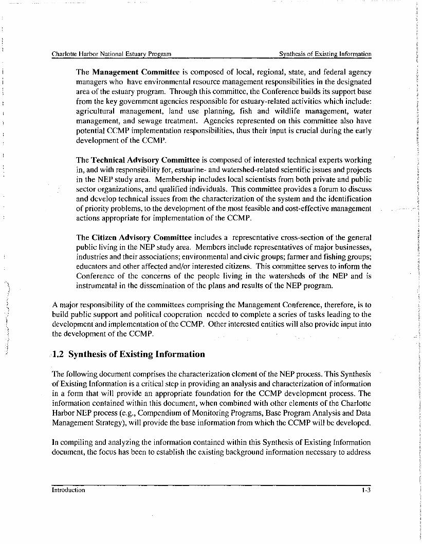
The Management Conference is the decision-making framework for carrying out the NEP process.The members of the Managemerit Conference work together in partnership to develop, throughconsensus, a master plan for the estuary called the CCMP. After the NEP has developed andadopted the CCMP, the CCMP is supported and carried out under state and local auspices.Essentially the members of the Conference identify major and significant potential problems (if any)in their estuaries, decide where to focus corrective actions, and agree to specific political, financial,and institutional commitments. Figure 1-1 illustrates the agencies, organizations, and interestedparties, including the committees of the Management Conference, who provide critical input to, andreview of, the CCMP.
The Management Conference is composed of a Policy Committee, a ManagementCommittee, a Technical Advisory Committee (TAC), and a Citizen Advisory Committee(CAe). Through its committee structure and public outreach efforts, the Conferenceprovides a forum for collaborative decision-making and consensus building around oftenconflicting issues.
The Policy Committee is composed of key officials (mayors, county commissioners, agencychiefs, etc.) or their designees, who help provide the resources to support the ManagementConference. This committee makes the final decisions after considering the needs of theestuary ecosystem, the cost and benefits of restoration and protection strategies, and thevalue the community may be placing on the estuary.
Introduction 1-1
Charlotte Harbor National Estuary Program Synthesis of Existing Information
Figure 1-1. Organization of agencies, organizations, and interested parties, including thecommittees of the Management Conference, who provide critical input to, andreview of, the CCMP.
. Introduction 1-2
Charlotte Harbor National Estuary Program Synthesis of Existing Information
The Management Committee is composed of local, regional, state, and federal agencymanagers who have environmental resource management responsibilities in the designatedarea of the estuary program. Through this committee, the Conference builds its support basefrom the key government agencies responsible for estuary-related activities which include:agricultural management, land use planning, fish and wildlife management, watermanagement, and sewage treatment. Agencies represented on this committee also havepotential CCMP implementation responsibilities, thus their input is crucial during the earlydevelopment of the CCMP.
The Technical Advisory Committee is composed of interested technical experts workingin, and with responsibility for, estuarine- and watershed-related scientific issues and projectsin the NEP study area. Membership includes local scientists from both private and publicsector organizations, and qualified individuals. This committee provides a forum to discussand develop technical issues from the characterization of the system and the identificationof priority problems, to the development of the most Jeasible and cost.,effectivemanagementactions appropriate for implementation of the CCMP.
The Citizen Advisory Committee includes a representative cross-section of the generalpublic living in the NEP study area. Members include representatives of major businesses,industries and their associations; environmental and civic groups; farmer and fishing groups;educators and other affected and/or interested citizens. This committee serves to inform theConference of the concerns of the people living in the watersheds of the NEP and isinstrumental in the dissemination of the plans and results of the NEP program.
A major responsibility of the committees comprising the Management Conference, therefore, is tobuild public support and political cooperation needed to complete a series of tasks leading to thedevelopment and implementation of the CCMP. Other interested entities will also provide input intothe development of the CCMP.
1.2 Synthesis of Existing Information
The following document comprises the characterization element of the NEP process. This Synthesisof Existing Information is a critical step in providing an analysis and characterization of informationin a form that will provide an appropriate foundation for the CCMP development process. Theinformation contained within this document, when combined with other elements of the CharlotteHarbor NEP process (e.g., Compendium of Monitoring Programs, Base Program Analysis and DataManagement Strategy), will provide the base information from which the CCMP will be developed.
In compiling and analyzing the information contained within this Synthesis of Existing Informationdocument, the focus has been to establish the existing background information necessary to address
Introduction 1-3
Charlotte Harbor National Estuary Program Synthesis of Existing Information
the three Priority Problems that have been identified as having the greatest potential for degradingthe Charlotte Harbor system. These problems are:
1) Hydrologic Alterations = adverse changes to amounts, locations, and timing offreshwater flows, hydrologic function of floodplain systems, and natural river flows.
2) Water Quality Degradation = including but not limited to pollution fromagricultural and urban runoff, point source discharges, septic tank system loadings,atmospheric deposition, and groundwater.
Fish and Wildlife Habitat Loss = degradation and elimination of headwater streamsand other habitats caused by development, conversion of natural shorelines,cumulative impacts of docks and boats, invasion of exotic species, and cumulativeand future impacts.
The CHNEP study area encompasses over 4,500 square miles along the southwest coast of Florida(Figure 1-2), and covers eight distinct sub-areas, or major basins, based on hydrologic, ecologic,and management characteristics (State of Florida, 1995). These previously identified basins include:
• Peace River,• Myakka River,• Coastal Venice,• Charlotte Harbor Proper,• Lemon Bay/Gasparilla Sound/Cape Haze Complex,• PineJsland Sound/ Matlacha Pass,• Tidal Caloosahatchee River, and
• Estero Bay.
Addressing elements of the three identified Priority Problems as they relate to each of these majorbasins will be a primary focus in development of the Charlotte Harbor NEP CCMP. To accomplishthis, the following Synthesis of Existing Information seeks to:
•••
•Introduction
identify and compile relevant sources of information;
to assess trends in the estuary's water quality, natural resources, and uses;
to assess pollution loadings to the estuary and relate them to obser/ed changes inwater quality, natural resources, and land use; and
to identify potential environmental problems.
1-4
Charlotte Harbor National Estuary Program Synthesis of Existing Information
,
"
,,,,,
,~""·,·,· ,· ,, ,. ,
. 0°0:
f
,
,
GULF OFMEXICO
Venice
CHARLOTTEHARBOR
/'\/'County Boundanes
N Major Roads
N Major Rivers
N Charlotte Harbor NEPBasm Boundancs
',,,
Charlotte Harbor NEP
*0 5 10 15 20 Milesi
aT EHc
\)"ona I Estuary 1',0IJIIC:' 02089910-32060• -..w.; e: chnep locator-apr
Figure 1-2. Charlotte Harbor NEP study area.
Introduction 1-5
Charlotte Harbor National Estuary Program
2. Myakka River Basin
Synthesis of Existing Information
This chapter presents a compilation and synthesis of information regarding the Myakka River Basinportion of the Charlotte Harbor NEP area (Figure 2-1). The following sections provide:
• a characterization of the physical setting, including topographic, geologic, soils, andland use descriptions of the basin;
• a review of the rainfall and hydrologic characteristics of the basin;
• a review of the water management practices and water uses within the basin;
• a summary of current and historical water quality conditions; and
• an estimation of pollution potential from nonpoint and point sources within thebasin.
2.1 Physical Setting
The Myakka River Basin is located in the northwestern portion of the Charlotte Harbor NEP studyarea, with the Peace River to the east, the Manatee River to the north, Charlotte Harbor to the south,and a number of smaller coastal streams to the west. The headwaters of the river are in eastern
-.-,Manatee,County.near Myakka Head,and the river flows in a southerly direction through Manatee,Sarasota, and Charlotte counties, where it empties into northwestern Charlotte Harbor at Hog Island.The basin is approximately 600 square miles in area. The basin can be divided into two subbasins:
the Upper Myakka River subbasin (area=372 square miles), which extends from theheadwaters to the USGS gaging station near Sarasota; and
• the Coastal Lower Myakka Basin (area=225 square miles), which extends from theUSGS gage to the mouth of the river near Hog Island (Figure 2-1).
Deer Prairie Creek and Big Slough are the principal tributaries to the Myakka River. Near theheadwaters there is a large depression known locally as Flatford Swamp and marshes and swampswithin the Myakka River Basin provide surface water storage. The Myakka River is the only streamchannel that is primarily well-defined and naturally entrenched throughout its course in the basin.
Myakka River Basin 2-1
Charlotte Harbor National Estuary Program
MANATEECOUNTY
LOCATION
Myakka River Basin
+012345Mile,M _
Synthesis of Existing Information
HARDEECOUNTY
PRCllOnO.60 01/09199• ..,." e:\chncp\chnep.apr
Figure 2-1. Location of the Myakka River basin in the Charlotte Harbor NEP study area.
Myakka River Basin 2-2
Charlotte Harbor National Estuary Program
2.1.1 Physiography
Synthesis of Existing Information
This section describes the topography, geology, soils, and land use in the Myakka River.
2.1.1.1 Topography
The maximum elevation within the Myakka River watershed is 116 feet (Joyner and Sutcliffe,1976). Upper Myakka Lake has a water surface elevation of 13.6 feet above mean sea level (MSL)and the surface of Lower Myakka Lake is 9.9 feet above MSL.
The topography of the Myakka River Basin represents a series of relict marine terraces and ischaracterized as low flatlands, with moderate to gentle slopes limited to the peripheral areas in thenorthem,half of the watershed. The terrain is generally flat and elevations along the Myakka Riverrange from 0 feet above MSL along the tidally influenced coastal portion at the mouth of the riverin Charlotte County to 50 feet above MSL in Sarasota County and to about 115 feet above MSL atthe headwaters. The land along the upper reaches of the Myakka slopes about five feet per mileand then decreases to about 1 foot per mile near the mouth of the river. In some of the lowerreaches, the floodplain may reach three miles in width.
The basin is characterized by lowlands along the coast, including most of the Myakka River Basinwithin Sarasota County. Farther north and east, within the DeSoto Plain, elevations graduallydecrease from 100 to about 30 feet above MSL beyond the Myakka River Basin, separated by theWicomico Terrace from the higher and more irregular terrain of the Bone Valley Uplands.
2.1.1.2 Geology
The Myakka River lies within two prominent physiographic regions, the Gulf Coastal Lowlands and"theDeSoto Plain of the Central orMid-Peninsular Zone of Florida. The watershed is part of the
Manasota Basin and dominates the eastern and central portions of Manatee and Sarasota Counties,respectively. Most of the basin lies within the Gulf Coastal Lowlands. The Gulf Coastal Lowlandsphysiographic area parallels and borders the western coastal areas of the state. The surface andsubsurface geology of the Myakka River basin are directly related to fluctuations in sea level. Therise and':fall of sea level through geologic time resulted in the deposition of limestone and othersedimentllry rocks.
The primary hydrogeologic units in the Myakka River Basin include the surficial aquifer, twointermediate aquifers and confining units, and the Floridan aquifer. The surficial aquifer iscontained within the surface deposits, the Caloosahatchee Marl and the Bone Valley formation. Theintermediate aquifers are contained in the Tamiami and Hawthorn Formations and parts of theTampa Limestone. The Floridan aquifer includes part or all of the Tampa limestone, SuwanneeLimestone, Ocala Limestone, and the Avon Park Limestone (Joyner and Sutcliffe, 1976).
In the northern portion of the Myakka River basin, the Floridan aquifer is the primary source ofgroundwater for irrigation and human consumption. The water table is approximately within 5 feet
Myakka River Basin 2-3
Charlotte Harbor National Estuary Program Synthesis of Existing Information
of land surface in the basin. There are seasonal fluctuations in the water table. Lowest water tablelevels typically occur during Mayor June and the highest water table levels occur in September orOctober. The quality of water in the surficial and intermediate aquifers is usually acceptable forpotable water except near the coast where water from the Floridan aquifer is too mineralized forpotable water use and is used primarily for agricultural purposes (Hammett, 1988).
The intermediate aquifers consist of an upper (Tamiami-upper Hawthorn) unit containing phosphaticmarl, shell, sand, clayey sand, and phosphatic limestone of mid-Miocene to Pliocene age, and alower (lower Hawthorn-upper Tampa) unit made up of permeable limestone and dolomite of lowerand mid-Miocene age (Duerr and Wolansky, 1986; Hammett, 1988). Thickness of the upper unitranges from 200 to 400 feet, and the lower unit from 150-300 feet. The two aquifers are separatedby a confining bed of relatively impermeable clay material, although breaches of the confining layerhydraulically connect the two.
There are two major springs, Little Salt Springs and Warm Mineral Spring, within the Myakka Riverbasin. These springs discharge to the Myakka River via tributary channels. Little Salt Springscurrently generates little if any flow. Warm Mineral Springs discharges through a tiibutary to theMyakka River. The discharge water is very saline and results from artesian flow from the Floridanaquifer.
Springs, seeps, and sinkholes indicate the presence of connections between the surficial aquifer anddeeper water bearing units in the watershed. In the Myakka River Basin, the river channel and mostlakes are underlain by impermeable clays. Surficial materials are dominantly sandy, occasionallywith relatively clayey substrata, and with significant organic deposits. The Upper Myakka subbasinlies partially within the Central Lake district, a sandhill karst terrain with innumerable solutionbasins, and the principal recharge area of the Floridan aquifer (Stewart, 1980). The Upper andLower Myakka Lakes appear to be solution features connected to lower aquifers.
The lower Hawthorn-upper Tampa aquifer is recharged by lateral flows and upward leakage fromthe Floridan aquifer, and discharges to the Tamiami-upper Hawthorn aquifer. In some portions ofthe basin the Tamiami-upper Hawthorn aquifer is also recharged by downward leakage from thesurficial aquifer. A dense layer of impermeable clay in the most northern portion of the basin formsan impermeable layer between the overlying sandy material and underlying limestone and producesnumerous collapse sinkholes in which the clay initially forms a bridge over a developing limestonecavity. Failure of the bridge leads to a sinkhole that may be small or very large. These sinkholesare rare farther south in the basin where the sedimentary cover is more than 60 meters thick.
Myakka River Basin 2-4
Charlotte Harbor National Estuary Program
2.1.1.3 Soils
Synthesis of Existing Information
The National Resource Conservation Service (NRCS) county soil reports and map provided mostof the information discussed in this section. Flatwoods soils comprise the majority of the MyakkaRiver Basin in Sarasota County, including the Eugallie-Myakka-Holopaw-Pineda and PomelloMyakka-Eugallie series. They are nearly level, poorly drained to very poorly drained and have asandy surface layer and sandy and loamy subsoils. Flatwoods and sloughs soils occurpredominantly as Myakka, Oldsmar, and Immokalee soils series, or combinations of these. Thesesoils are nearly level, poorly drained, sandy, and have loamy subsoils and the differences in thesesoil types are primarily related to the depth of organic-stained subsoils. Soils associations adjacentto the river channel occur as Felda series combinations. These soils are poorly drained sands overbeds ofsandy and loamy marine sediments and are characteristic of floodplains. The lower portionof the Myakka River in Sarasota County is a Kesson-Wulfert soil and is associated with mangroveswamps;
In the Coastal Lower Myakka subbasin, dominant soil types are Oldsmar-Myakka, Wabasso-PinedaBoca, and Immokalee-Myakka soils across nearly 90% of the watershed in Charlotte County.Myakka and Immokalee soils are very poorly drained, while the Pomello and Cassia soils aremoderately to well-drained soils of low ridges. The mouth of the Myakka River is characterized byPeckish-Estero-Isles tidal and barrier island soils (poorly drained mucky fine sands) in CharlotteCounty.
The Upper Myakka subbasin occurs in Manatee County where the flatwoods soils occur onWaveland-Pomello-Myakka and Myakka-Waveland-Cassia series across approximately 75% of thecounty. Hammock, floodplain, depression, and marsh soils also occur along the rivers. The soils-in-the DeSoto Plain in the'most northeastern portion of-this-subbasin are characterized as nearlylevel, poorly drained, sandy soils, with weakly cemented sandy subsoil and poorly drained sandysoils throughout. The soils at the headwaters are nearly level sandy soils with dark subsoil.
Each soifseries can be classified into a hydrologic soil group (HSG) based on its runoff-producingcharacteristics. The most important of these characteristics is the capacity of the soil to permitinfiltratioh when bare of vegetation. The four major hydrologic soil groups are described below.
Group A (low runoff potential) - soils with high infiltration rates even whenthoroughly wetted. Composed primarily of sands and gravel that are deep and wellto excessively drained. These soils have a high rate of water transmission.Minimum infiltration rate is 0.30-0.45 inlhr.
Group B (low to moderate runoff potential) - soils with moderate infiltration rateswhen thoroughly wetted. The soils are typically moderately fine to moderatelycoarse in texture and have a moderate rate of water transmission. Minimuminfiltration rate is 0.15-0.30 in/hr.
Myakka River Basin 2-5
Charlotte Harbor National Estuary Program Synthesis of Existing Information
Group C (moderate to high runoff potential) - soils with slow infiltration rates whenthoroughly wetted, often with a layer of soil that impedes the downward movementof water. The soils typically have a moderately fine to fine texture and a slow rateof water transmission. Minimum infiltration rate is 0.05-0.15 inlhr.
Group D (high runoff potential) - soils with very slow infiltration rates whenthoroughly wetted. Primarily clay soils with a high permanent water table orshallow soils over nearly impervious materials, such as a clay pan or clay layer.These soils have a very slow rate of water transmission. Minimum infiltration rateis 0.0-0.05 inlhr.
A and B soils exhibit lower runoff potential and are better drained when compared to C and D soils.Most soils within the Myakka River Basin are classified hydrologically as hydrological soil group(HSG) BID, as assigned by the NRCS. The BID designation is assigned when a soil type exhibitsdifferent runoff characteristics under developed ("improved") and undeveloped conditions."Improved" conditions which provide better drainage to a soil type are then designated B, whilesoils remaining in a less well-drained undeveloped condition are designated as a D soil. TheMyakka River Basin includes approximately 73% B soils, nearly 20% D soils, and almost 8% ofthe basin with Aor C soils (Table 2-1) (Figure 2-2).
Upper Myakka Lower Coastal MyakkaSoil Type
Acres % Acres %
A 6,101 4.2 104 <0.0
B 114,742 79.7 165,196 69.4
C 14,093 9.8 9,016 3.8
D 8,978 6.2 63,881 26.8
TOTAL 143,913 100.0 238,197 100.0
2.1.2 Rainfall
The data discussed in this section were obtained from the National Weather Service, SWFWMD,or SFWMD. Rainfall in the Myakka River Basin, like the other basins, is a product of a wetsubtropic (humic mesothermal) climate with a warm summer and no dry season, similar to the entireCharlotte Harbor NEP watershed. Annual precipitation on the Myakka River is about 50-55 inches,
Myakka River Basin 2-6
Charlotte Harbor National Estuary Program Synthesis of Existing Infonnation
Di.,AIDWTi'j" ....·.B.. · BID::::::r::: .. 'IIIIIII1II'C: CID_n~mr¥@1 Water
HYDROLOGIC SOIL GROUPSMyakka River Basin
+012345Mtles,...-...-----. DRCI 10320.60 01109/99
......J e:\chnep\hmdu&'e.apr
Figure 2-2. Hydrologic soil groups in the Myakka River basin.
Myakka River Basin 2-7
Charlotte Harbor National Estuary Program Synthesis of Existing Information
with generally 6-8 months of low rainfall (2.0-2.5 inches/month) and 4-6 months of heavy, butspatially variable rains (5-8 inches or more/month). November is the driest dry season month as aresult of the absence of both summer convection and winter frontal systems and the shift of tropicalstorms to the west of Florida. In mid-spring the frontal systems move north and the localseabreeze/convection circulation dominates the wet season rainfall. Most wet season rainfall isassociated with frequent, but highly localized thunderstorms. Day-long wet season storms areinfrequent and are generally associated with tropical disturbances. Heaviest wet season rainfall isassociated with an up air trough that is centered over southern Florida in early and late summer.
Basin rainfall patterns were modeled using data from a network of rainfall gages throughout theCharlotte Harbor watershed. Data from a total of 18 rainfall gages were used in modeling therainfall for the Myakka River Basin. Locations of these rainfall stations are shown in Figure 2-3.Total annual precipitation and average monthly precipitation from 1970 to present for the CoastalLower Myakka and Upper Myakka subbasins are presented in Figures 2-4 and 2-5, respectively.
Total annual precipitation and average monthly precipitation were very similar in the two subbasins.Minimum total annual precipitation ranged from approximately 40 inches of rain (observed in 1990)to about 75 inches of rain in both subbasins. Average monthly precipitation patterns were seasonaland typical for Florida. Rainfall was highest from June to September, and wet season averagevalues ranged from 7 to nearly 9 inches. Average monthly rainfall values were lowest duringNovember and December (appr.oximately 2 inches) and did not exceed 4 inches through May.Although there was a peak of nearly 4 inches in March, a bimodal pattern of wet season rainfallcharacteristic of south Florida was not apparent. Coastal Environmental (1996) examined the longterm trends in rainfall and flow in both the Peace and Myakka rivers and found a declining trend inrainfall for the Upper Myakka River with the estimated annual percent decline of 0.15%/year forthe period 1948-1993.
2.1.3 Existing and Future Land Use/Cover
Land use data were obtained from SWFWMD, SFWMD, and the Southwest Florida RegionalPlanning Council (SWFRPC). Although other sources of data were available for various portionsof the Charlotte Harbor NEP study area, these data sources provide a complete and consistentcoverage for the entire study area.
Existing and future land use GIS coverages for the Charlotte Harbor NEP area are not alwaysconsistent in land use codes and coverages. Existing land use coverage presented in this documentis a combination of 1990 Southwest Florida Water Management District (SWFWMD) and 1988South Florida Water Management District (SFWMD) land use data. Land Use data from
Myakka River Basin 2-8
Charlotte Harbor National Estuary Program
MANATEECOUNTY
•
• •..~,.
1.
RAIN MONITORING STAnONSMyakka River Basin
wf01ZJ45Mile,~~
Figure 2-3. Rain station locations in the Myakka River Basin.
Charlotte Harbor National Estuary Program Synthesis of Existing Information
Total Annual PrecipitationSubbasin=Coastal Lower Myakka
I I 11 I 1 I I I I 1 I 1 I 1 1 111 I I I I 1 I I' I It III I It 1 11 I I I I I I
100.00
90.00
80.00'2 70.000:-
J: 60.000
~ 50.00Do 40.00i 30.00a..
20.00
10.00
0.00
1970 1975 1980 1985
e--B-e full year
1990 1995 2000
Average Monthly PrecipitationSubbasin=Coastal Lower Myakka
11.00
10.00
9.00
8.00'2= 7.00c::0 6.00~ 5.00Do
~ 4.00
3.00
2.00
1.00
0.00
2 3 4 5 6 7 8 9 10 11 12
Figure 2-4. Total annual and monthly rainfall plots for the Coastal Lower Myakka subbasin.
Myakka River Basin 2-10
Charlotte Harbor National Estuary Program Synthesis of Existing Information
Total Annual PrecipitationSubbasin=Upper Myakka
100.00
90.00
80.00
70.00
liO.oo50.00
40.00
30.00,•...."'.'~
'20.00
10.00
0.00
1970 1975 1980 1985
e-B---e full year
1990 1995 2000
Average Monthly PrecipitationSubbasin=Upper Myakka
11.00
10.00
9.00
8.00'2c 7.00c:0 ,6.00I ,5.00Q.
~ '4.0011.
3.00
2.00
1.00
0.00
2 3 4 5 6 7 8 9 10 11 12
Figure 2-5. Total annual and monthly rainfall plots for the Upper Myakka subbasin.
Myakka River Basin 2-11
Charlotte Harbor National Estuary Program Synthesis of Existing Information
SWFWMD was based on Florida Department of Transportation (FDOT) "Florida Land Use andCover Classification System" (FLUCCS), Levels II and III (Appendix E). The SFWMD land usecategories, however, were identified using the District's own classification system (not FLUCCS).We evaluated the two systems and developed a hybrid that is now in use for this project.
Future land use coverages for the Charlotte Harbor NEP were developed by the SWFRPC.SWFRPC obtained future land use maps from all RPCs in the state, and digitized the maps todevelop a state-wide coverage. The future land use maps (FLUMs) are general and intended toguide future growth. They are not based on present conditions, nor do they recognize many featuresthat will probably be present in the future (such as smaller wetlands). Importantly, FLUMs providea 100% build-out scenario which does not take into account areas which will not be developed asresult of land use regulations and restrictions.
The FLUMs use a different and much simpler, land use classification system than either of theexisting land use coverages and does not identify existing developed-urban land use or land cover.A geographic area designated for future residential growth on the FLUM might encompass existingcommercial, institutional, or wetland areas (Rains et al. 1993). Residential areas, then, may increasetremendously under future scenarios because existing development is not taken into account.
. As a result, direct comparisons between acreages of a particular type of land use for existing andfuture conditions cannot be made without evaluating the criteria used to develop that land usecategory. In the Upper Myakka basin, existing single family residential land use includes 2,436acres (Table 2-2), while this same land use includes only 170 acres under future land use (Table 23). Total future residential (1,734 acres) is much more consistent with existing residential (2,436acres) in light of the other limitations to FLUMs, described above.
2.1.3.1 Existing Land Use and Land Cover
Existing land use in the Myakka River Basin includes 13% agriculture and 5% urban (Table 2-2).Areas of urban development occur primarily along the coastal areas in Sarasota and Charlottecounties (Figure 2-6) and increases in urban development are expected to be higher for the CoastalLower Myakka subbasin when compared with the Upper Myakka subbasin. Single family andmedium density residential land use acreages are presently nearly twice as high for the CoastalLower Myakka subbasin (3.5%) when compared with the Upper Myakka subbasin (1.8%) (Table2-2). Away from the coast, agricultural use is predominant and percentages of land use in pastureand rangelands are 45% and 57% for the lower and upper subbasins, respectively.
During 1990, phosphate mining resumed near Wingate Creek near the headwaters of the river andis expected to continue (Sarasota County, 1993). Most hydrological alterations in the watershedwere initiated between the early 1940's and early 1950's. Dredging and canal excavation havecontinued since that time.
Myakka River Basin 2-12
Charlotte Harbor National Estuary Program
LANDUSE
Myakka River Basin
~012345Mile.~-..---.I
Synthesis of Existing Information
_ Strip Mines, Quarries,Sanlland Gravel PitsUrban and Built Up LandAgriculture .RangelandBarren Land
f:::::::1 Upland Foresto Wetlands~Jtii§1 Water
PBSJ 10320.60 01109/99e:'chncp\landuFc.apr
Figure 2-6. Existing land use map (SWFRPC, 1990) for the Myakka River Basin.
Myakka River Basin 2-13
Charlotte Harbor National Estuary Program Synthesis of Existing Information
Charlotte Harbor National Estuary Program Synthesis of Existing Information
Forested uplands comprise 11.2% and 23-.6% of the Upper Myakka and Coastal Lower Myakkasubbasins land cover, respectively (Table 2-2). Forested freshwater wetland comprise 11.6% and7.3% of the Upper Myakka and Coastal Lower Myakka subbasins land cover, respectively.Nonforested 'freshwater wetlands are the other major natural land cover, comprising 8.4% and13.4% in the upper and lower basins, respectively.
2.1.3.2 Future Land Use
Future land use changes defined by the SWFRPC (Figure 2-7) indicate a substantial increase inagriculture and a smaller increase in urban land use in the Coastal Lower Myakka subbasin (Table2-3). In contrast, an increase to 90% agriculture and a decrease to less than 1% urban are includedin the2bpnty future land use maps for the Upper Myakka River subbasin (Table 2-3, Figure 2-7).Categories other than agricultural and urban, such as upland forest, rangeland, and pasture land usesmay convert to urban land uses in the unlikely event of 100% build-out in the basin.
Upper Myakka Lower Coastal MyakkaLand Use/Cov~r
Acres % Acres %
Single Family Residential 170 0.1 45,725 19.5
Multi-family Residential 280 0.2 4,528 1.9
Rural Residential 1,287 0.9 27,747 11.9
Commercial 0 0 4,577 2.0
Industrial 0 0 1,362 0.6
Mining 56 <0.1 5,058 2.2
Agricultural 129,163 89.3 95,114 40.6
Wetlarid,~ 939 0.6 764 0.3
Protected Resource 12,719 8.8 49,229 21.0
TOTAL 144,614 100.0 234,104 100.0
2.1.4 Surface Water Hydrology and Water Management Practices
This section discusses the spatial and temporal patterns of surface water hydrology and examinesurban and agricultural water management practices.
Myakka River Basin 2-15
Charlotte Harbor National Estuary Program
FUTURE LAND USE
Myakka River Basin
+o 1 1 3 4 5 MIles~-......,
Synthesis of Existing Information
DllC.I 10332240 02 20 99• ~J e: chnep CuUuse.apr
Figure 2-7. Future land use map (SWFRPC, 1990) for the Myakka River Basin.
Myakka River Basin 2-16
Charlotte Harbor National Estuary Program
2.1.4.1 Surface Water Hydrology
Synthesis of Existing Information
The primary conveyance in this basin is the Myakka River. Two springs flow into the lowerMyakka River, Little Salt Spring and Warm Mineral Spring. Little Salt Spring currently hasnegligible flow, and historically flowed at only a few cubic feet per second (cfs). Warm MineralSpring discharges to a pool and then flows two miles to the Myakka River, with an averagedischarge of approximately 10 cfs. In addition, Big Slough Canal and Deep Prairie Creek flow intothe Myakka River in its southern reaches from the northeast, both draining largely rangeland areas,with Big Slough Canal channelized in its upper reaches to enhance drainage. The downstreamportion of Big Slough Canal flows through some urbanized areas and receives drainage fromresidentia.Jcanals. In the upper reaches of the Myakka River are found Lower and Upper MyakkaLakes, while farther upstream are the Tatum Sawgrass and Flatford Swamps.
There areremnants of two streamflow control structures on the Myakka River and they affect theriver morphology. In 1941, a levee was constructed at the upper lake outfall to divert water awayfrom adjacent low-lying pastureland and to retain water in the lake during droughts (Flippo et aI.,1968). Although a control weir was included in that levee, it is no longer operated and remainsopen. However, it is estimated that the levee impedes flow in the river sufficiently to keep the waterlevel of Upper Myakka Lake one to two feet higher than prior to levee construction. The southstructure remnant is a dam or levee that was constructed to stabilize the water level in Lower LakeMyakka. Although only traces o~ this levee remain, it still impedes flow to a small degree.
Other streamflow control structures include Down's Dam, a private dam located 0.25 miles southof the Myakka River State Park, and Dams on Deer Prairie Creek and Big Slough Canals. CurryCreek, also called Blackburn Canal, is dammed between the river and Dona Bay.
Total monthly streamflow data were obtained from USGS monitoring records for the CharlotteHarbor watershed and streamflow patterns were examined. The locations of gaging stations in theMyakka River Basin are shown in Figure 2-8. Flow records from these stations are presented inAppendi~ RThere is an atmospheric-deposition monitoring station at the Verna Wellfield, as well.
The My~kkaRivernear Sarasota station provides the longest period of record and the total annualflow and average monthly flow are presented in Figure 2-9. Over the period of record the totalannual flow was typically in the range of 2,000 - 4,000 cfs. Streamflow exhibited large variationin discharges with mean monthly flows ranging from 100 to 700 cfs, but have seasonallycharacteristic patterns. Maximum discharges occurred in September, near the end of the summerrainy season and are generally associated with hurricanes or tropical storms. Streamflow is lowestin winter and late spring. As would be expected, flow patterns are consistent with rainfall patternsas described above). A long-term decline in wet season stream flow in the Myakka has beendescribed previously using data for the period 1940 through 1992 (Coastal Environmental, 1994).
Myakka River Basin 2-17
Charlotte Harbor National Estuary Program Synthesis of Existing Information
MANATEECOUNTY
HYDROLOGY MONITORING STATIONS
Myakka River Basin
+012345Milc,
~---Figure 2-8. USGS monitoring stations in the Myakka River Basin.
Myakka River Basin
HARDEECOUNTY
tu.IJRC.f 10320.60 0l/09i!l9•~ e:\chnep\chnep.apr
2-18
Charlotte Harbor National Estuary Program Synthesis of Existing Information
-----------------------------------------------,
Total Annual Flow02298830 - MYAKKA RIVER NR SARASOTA, FLA.
8000
7000
6000
I 5000
~4000
rr: 3000
2000
,1000
01 II 1 II I 11TTTTI i 11111 III i III i i [i IIII i IllLt i 1111 i III (II III III III i I (j i 11 i! I (i i ill j tIl i [I i II i III III i II i 11111
Average Monthly Flow02298830 - MYAKKA RIVER NR SARASOTA, FLA
o
Jan Feb Mar Apr May Jun Jul Aug Sep Oct Nov Dec
Figure 2-9. Plots of total annual flow and average monthly flow at station 02298830 in the MyakkaRiver Basin.
Myakka River Basin 2-19
Charlotte Harbor National Estuary Program Synthesis of Existing Information
Figure 2-9 illustrates the decline in wet season flows for the Myakka River near Sarasota. This sametrend was not identified by Hammett (1988) for a twenty-five year period ending in 1981.
Water Use
Urban water uses include public water supply, mmmg facilities, industrial operations, andrecreational uses. This discussion of water use is focused on facilities with an average permittedquantity greater than 0.5 million gallons per day (MGD). All water use information for those partsof the Charlotte Harbor NEP study area within the borders of the SWFWMD, including the entireMyakka River Basin, is from SWFWMD (1997) and SWFWMD (1992).
- Public Supply
Table 2-4 shows the public water supply facilities in the Myakka River Basin with permittedwithdrawals of more than 0.5 MGD, as well as the withdrawal sources for the facilities. Adiscussion of the populations served by each plant, withdrawal amounts, and withdrawal methodsfollows.
Table2:J4•. Public water sup.ply facilities in the My«kka River Basin.···
Facility
City of North Port
City of Sarasota
Permitted AverageWithdrawal (MGD)
2.1
12.0
Source
Myakkahatchee Creek
Upper, Intermediate Floridan aquifers
The City of North Port obtains its public water supply from a water treatment facility via surfacewater withdrawal from Myakkahatchee Creek (Big Slough Canal), This plant was -previouslyowned and operated by General Development Utilities (GDU) (SWFWMD, 1992), but is currentlyowned and operated by the Peace River/Manasota Regional Water Supply Authority (PRMRWSA).Withdrawals from Myakkahatchee Creek in the future may be limited due to supply and waterquality problems, with future supply being likely supplemented by the Peace River Regional WaterTreatment Plant (SWFWMD, 1992). Permitted average withdrawal for the facility is 2.1 MGD.This facility supplied an estimated population of 12,181 with 1.63 MGD during 1990 (SWFWMD,1992).
The City of Sarasota utilizes groundwater from the Myakka River Basin for its public water supply.The Vema Wellfield, located near the boundary of Manatee County and Sarasota Countyapproximately 17 miles east of Sarasota, is partially in the northwestern portion of the MyakkaRiver Basin. The City of Sarasota withdraws from 39 wells in Vema Wellfield. The wells arebetween 500 and 600 feet deep, and withdraw from the Upper Floridan aquifer. The permittedwithdrawal from this source for the City of Sarasota averages 6.0 MGD. The city also operates six
Myakka River Basin 2-20
Charlotte Harbor National Estuary Program Synthesis of Existing Information
wells located within the city limits. These wells are 345-650 feet deep, and withdraw from theIntermediate and Upper Floridan aquifers. The permitted average quantity for the entire system is12.0 MOD. An estimated population of 54,186 was provided with 8.41 MOD during 1990 by thisplant (SWFWMD, 1992).
- Mining
Mining land use accounts for 737 acres of the Myakka River Basin, only 0.2% of the total area ofthe basin. Mining is confined to the Manatee and Sarasota counties portions of the basin. Withinthe Myakka River Basin are found two mining facilities. Table 2-5 lists the mining operations,permitte-d:average and maximum withdrawals, and withdrawal source for each mine.
Myakka River Resource, Inc.
Nu-Gulf Industries, Inc.
Permitted AverageWithdrawal (MGD)
1.21
6.41
Groundwater
Groundwater
The Myakka River Resources, Inc., mining operation is in Sarasota County, and has a permitted. average withdrawal from groundwater sources of 1.21 MOD. During 1994, the facility utilized itsentire permitted withdrawal. The remaining mining facility is operated by Nu-Oulf Industries, Inc.,in Manatee County. This facility has a permitted average withdrawal from groundwater sources of6.41 MOD, and also utilized its entire permitted withdrawal in 1994.
- Industrial
Industrialland use in the Myakka River Basin totals 71 acres, only 0.02% of the basin total. Nofacilities are identified in SWFWMD, 1997, within the Myakka River Basin which have greater than0.5 MOD.average permitted withdrawals.
- Recreational
Golf courses and landscape (parks, medians, attractions, cemeteries, and other green areas) wateruse locations are not identified by SWFWMD (1997), so no basin-specific water use is associatedwith these land uses. However, water use by county for golf courses and landscape for that portionofthe county within the SWFWMD is provided. Sarasota County water use for golfcourses in 1994was 7.9 MOD, and landscape water use for the same time period was 0.4 MOD, for a totalrecreational use of 8.3 MOD for the county. In Manatee County, golf course water use was 3.0MOD in 1994, and landscape water use was 0.1 MOD, totaling 3.1 MOD for the county. Portionsof Charlotte County within the SWFWMD had water use for golf courses in 1994 of 2.9 MOD, and
Myakka River Basin 2-21
Charlotte Harbor National Estuary Program Synthesis of Existing Information
landscape water use for 1994 was 0.5 MGD, for a total recreational usage of 3.4 MGD for thecounty.
Water Discharge and Reuse
The Myakka River Basin is provided wastewater treatment services by two plants located in thesouthern portion of the basin. These two domestic waste water treatment plants are associated withthe urbanized areas in the southern part of the basin. The Myakka Utilities Waste Water TreatmentPlant (WWTP) discharges some effluent to percolation ponds, with the remainder used for sprayirrigation (Zarbock et al., 1995). The City of North Port WWTP discharges effluent to percolationponds as well, with the remainder of its effluent utilized for spray irrigation.
I,pdustrial point source waters are discharged by the two Nu-Gulf Industries Wyngate Creek Mineotltfalls in the northern half of the basin.
2.1.4.2 Agricultural Management Practices
The description of agricultural management practices in the Myakka River Basin, and all remainingbasins of the Charlotte Harbor NEP study area, depends upon a knowledge of the types ofmanagement practices utilized in the area, specifically those dealing with irrigation. The followingdiscussion of general background information precedes the specific description of the practices inthe Myakka River Basin.
Irrigation types may be divided into overhead, low volume, and seepage systems. Overheadsprinkler systems apply irrigation water over the top of the irrigated crop. Low volume systemsdeliver irrigation water through a network of plastic pipes to the immediate vicinity of the individualplant, and include drip, trickle, and micro jet systems. Seepage systems involves the application ofirrigation waters to a crop via a network of ditches or underground pipes" with waterdeJivereddirectly to the root zone (SWFWMD, 1992).
Irrigation types may vary for an individual crop throughits establishmentand growth phases. Forexample, establishment of strawberry crops may utilize overhead irrigation, with low volumeirrigation used during the growing phase of the crop. Similarly, vegetable crops may be establishedutilizing seepage irrigation, with low volume systems used later for crop growth and production(SWFWMD, 1992).
As discussed previously, agriculture is a major land use within the study area of the CharlotteHarbor NEP watershed. As such, the management practices utilized on agricultural lands can haveadverse impacts on the quantity and quality of soils, surface water, and groundwater in much of the
Myakka River Basin 2-22
Charlotte Harbor National Estuary Program Synthesis of Existing Information
study area. Likewise, through improved environmental performance of farming systems, anexcellent opportunity exists for large-scale improvement in water and soil quality and quantity.
The prevalent land uses within the Myakka River Basin, according to the 1990 SWFWMD land usecoverage, are dominated by rangeland and pasture land uses. Agricultural land uses in addition topasture only cover approximately 3% of the basin, with the largest of these being row and fieldcrops (7,885 acres). Citrus groves only occur on approximately 3,673 acres (see Table 2-2).
The 1990 SWFWMD and 1988 SFWMD land use coverages provide ageneral depiction of the arealdistribution of agricultural crops in the Charlotte Harbor NEP study area. For the purposes ofdefining~~istingagricultural management practices at the resolution of each study basin, other moredetailed sources of agricultural information were combined and integrated.
The agricultural information obtained describes crop types and acreages, water usage, and irrigationpractices for each county within the SWFWMD portion of the watershed, and crop types, acreages,and water usage in the Lower West Coast region of the SFWMD. The information available from
'the SWFWMD and the SFWMD (SWFWMD, 1992, and SWFWMD, 1997; SFWMD, Vols.1I andIII, 1994, respectively) was considered the most recent and accurate information in terms of whichcrop types and irrigation practices are utilized in specific areas of the watershed. The land usecoverages from the Districts were considered the best information available to delineate fieldboundaries of crop types. The county-wide totals for irrigation practices by crop type only allowedgeneral descriptions of irrigation practices. Irrigation types as referenced in SWFWMD (1994)include overhead, low volume, and seepage irrigation for vegetables, citrus, irrigated pasture, sod,nursery, and other agronomic crops, as determined from SWFWMD Water Use Permits.
,,c'Fhe agricultural-land use area within Manatee County in 1990 was estimated by SWFWMD (1994).The areas given to all major crops, including agronomic crops (corn, peanuts, soybeans, tobacco,etc.), row and field crops, citrus, nurseries, sod, and irrigated pasture were included in theseestimates. Irrigated acreages for each of these crops was also estimated, as well as estimated wateruse. Total 1990 agricultural acreage from this estimate for the entire county was 52,325 acres, withan associated estimated water use of 121.0 MGD (SWFWMD, 1994). The estimated crop acreages,irrigation types, and estimated water use for all of Manatee County are listed in Table 2-6.
The agricultural land use area within Sarasota County in 1990 was estimated by SWFWMD (1994).The areas given to all major crops, including agronomic crops, row and field crops, citrus, nurseries,sod, and irrigated pasture were included in these estimates. Irrigated acreages for each of thesecrops was also estimated, as well as estimated water use. Irrigated acreages for each of these cropswas also estimated, as well as estimated water use. Total 1990 agricultural acreage from thisestimate for the entire county was 10,875 acres, with an associated estimated water use of 24.9MOD (SWFWMD, 1994). Table 2-7 shows the estimated crop acreages, irrigation types, andestimated water use for all of Sarasota County.
Myakka River Basin 2-23
Charlotte Harbor National Estuary Program Synthesis of Existing Information
Crop Acreage Irrigation Type -Acreage Water Use (MGD)
Crop Acreage IrrigationType-· . Acreage Water Use (MGD)
Agronomic 200 Seepage 200 0.2
RowlField 3,100 Seepage 3,100 9.1Crops
Citrus 1,800 Low Volume 1,530 3.2Seepage 180
Nursery 220 Overhead 220 1.5
Sod 5,000 Seepage 5,000 10.0
Irrigated 555 Seepage 555 0.9'Pasture
TOTALS 10,875 Low Volume 1,530 24.9Seepage 9,035
Myakka River Basin 2-24
Charlotte Harbor National Estuary Program
Southern Water Use Caution Area (SWUCA)
Synthesis of Existing Information
In August of 1994, the SWFWMD published a notice stating that the District intended to adopt aset of rules to "prevent further adverse effects resulting from excessive withdrawals" in the proposedSouthern Water Use Caution Area (SWUCA). The set of rules was intended to provide specificregulatory guidelines concerning water use permitting. The proposed set of rules involvedamendments and additions to the District's existing water use permitting rules, modifications to theDistrict's Basis of Review (BOR), and a new rule which would establish minimum aquifer levelswithin the SWUCA. By October 1994, several organizations had challenged the proposed rules.The final list of petitioners included Charlotte, Pinellas, DeSoto, Hardee, and Polk counties, theEnvironmyntal Confederation of Southwest Florida, Inc., G B S Groves, Inc., and Citrus GrowerAssociate~, Inc.
The proposed SWUCA was the result of several District studies of water resources within itsboundaries. The SWUCA comprises most of the District south of the Hillsborough River, totaling5,100 square miles, including all of DeSoto, Hardee, Manatee, and Sarasota counties, and portionsof Charlotte, Highlands, Hillsborough, and Polk counties. Coastal areas of Hillsborough, Manatee
.and Sarasota counties have been a source of concern since the mid-to-late 1980's because ofdeteriorating water quality in wells drilled into the Upper Floridan Aquifer System (UFAS), which
. is more confined in the Southern Groundwater Basin, as identified by the District, than in otherportions of the District. This conc~rn lead to initiation of the Eastern Tampa Bay Water ResourcesAssessment Project (ETB WRAP) during the 1980's.
One of the principal objectives of the ETB WRAP was to develop tools or mechanisms for theDistrict to utilize in regulating water use. The District sought to develop a safe yield for the region,with safe yield being the level of use which can be sustained without causing unacceptable effects,comprised of both hydrologic and socioeconomic components. During the ETB WRAP,unacceptable impact was considered to be any further landward movement of saltwater-freshwaterinterface". so that safe yield was viewed as a quantification of the amount of water that could bewithdra\y;~ from existing wells in the ETB WUCA without producing significant additionalmovement of the transition zone.
As part of the ETB WRAP, two safe yield scenarios were analyzed. The first was a reduction ingroundwater withdrawals to 100 MGD in the ETB WUCA, and the second was a reduction ingroundwater withdrawals in the ETB WUCA to 150 MGD and a limitation on groundwaterwithdrawals in the remainder of the basin to about 500 MGD. Modeling efforts showed that 1) ifpumping continued to increase as projected, the saltwater interface would affect water quality
. further inland, and 2) if 1989 water use levels continued into the future, saltwater would continueto replace fresh water in the aquifer. The District decided that results of the modeling using 1989water use were unacceptable, and thus selected potentiometric surfaces that occurred in 1991 as theproposed minimum level within the SWUCA. The 1991 levels reflect a reduction in groundwater
Myakka River Basin 2-25
Charlotte Harbor National Estuary Program Synthesis of Existing Information
pumpage from 1989 of approximately 30% within the ETB WRAP and approximately 15%throughout the SWUCA.
The ETB WRAP determined there had been a significant lowering of potentiometric surface levelsin the Southern Basin since pre-development, and those changes were directly related togroundwater pumping. The study also concluded that the UFAS in the Southern Basin was a highlytransmissive, well confined aquifer, and groundwater levels at any location in the Southern Basinwere found to be a function of cumulative groundwater withdrawals occurring throughout the Basin.Information obtained from this study, and from similar efforts in other regions of the District,prompted the District to focus its efforts on development of a water resources strategy for the entireSouthern Basin. In June 1989, the District established the ETB Water Use Caution Area (WUCA),along with two other WUCAs in its borders, because of its growing concerns regarding wetlandsimpacts, saltwater intrusion, and lowered lake levels. According to the District,final, long-termremediation and resource protection measures for ETB are embodied in the proposed SWUCARules.
The SWUCA includes portions of central and southern Hillsborough County that serve as sourcesfor current and anticipated future water production for the West Coast Regional Water SupplyAuthority and its member governments. The South Central Hillsborough Regional Wellfield inwestern Hillsborough County, is one of the wellfield facilities owned and operated by West Coast,and is the only West Coast wellfield currently in operation in the SWUCA. South Central is notcurrently linked with the Interconnected System. The effect of proposed SWUCA Rules on SouthCentral could have restricted production from the wellfield and necessitated West Coast's diversionof other system waters to service the South Central area, so that with no allowable increase inproduction from South Central, the Interconnected System would have been more highly relied uponfor water delivery for Hillsborough and other West Coast members, thus impacting wateravailability for Pinellas.
In the Southern Basin, saline water intrusion into freshwater within the UFAS is caused by a decline.in hydraulic potentials resulting from groundwater withdrawals from the UFAS. Within 6-10 milesof the coast, the chloride-rich portion of freshwater/saltwater transitionzone inthe Floridan aquiferhas approximately one degree of slope and almost always appears within the Avon Park Formation.of the UFAS. The upward and landward movement of this interface causes the lens of freshwaterin the aquifer to be replaced by non-potable water in some areas.
The District has calculated that an immediate fix for the problem is not necessary or even possiblewithout drastic reductions in pumping. The District is not only concerned with saltwater intrusionthat is currently occurring, but also with the existence of conditions in the potentiometric surfacethat encourage further and potentially more serious intrusion. While potentiometric levels willequilibrate quickly throughout the basin, the saltwater transition zone moves at the rate ofgroundwater flow, so that if all pumping within the basin were halted, potentiometric surfaces
Myakka River Basin 2-26
Charlotte Harbor National Estuary Program Synthesis of Existing Information
throughout basin would recover relatively quickly, but the saltwater transition zone would takelonger to return to pre-development conditions.
In April 1994, the District published a SWUCA Management Plan with the primary goal ofdeveloping a long-term strategy to significantly curtail or reduce the advance of saltwater intrusionand stabilize lake levels in Polk and Highlands Counties. Additional goals included preservationof the resource (including environmental features) and protection of existing legal uses. The Planincluded a number of proposed water conservation measures, including basing agricultural use onhigher efficiencies, permitting public supply use based on lower per-capita usage rate, and requiringother water users to increase water conservation as appropriate for the particular activity. The Planprojects that new alternative water sources can reasonably be pursued to offset existing groundwaterdemand and/or extend existing surface water sources. However, even if these projections are met,to stabilize saltwater interface and lake levels within the SWUCA, actual withdrawals from theconfined~;aquifers within the ETB area and the remaining SWUCA area had to be limited to 150MGD and 550 MGD, respectively.
A Supplemental Investigations Report, published in October 1994, concluded that the northernsection of the Southern Basin was more susceptible than the southern section to water qualitydeterioration from saltwater intrusion, and that the ETB WRAP's and the SWUCA ManagementPlan's prior estimates of cutbacks necessary to achieve safe yield may not halt landward movementof the saltwater interface.
The SWUCA Rules would impact water use permitting in several ways. No new withdrawals fromthe Floridan aquifer in the SWUCA would be considered until the minimum aquifer level isachieved and sustained for five years. Existing permitted quantities could be reallocated to different·uses.and-Iocations, and water use permitdurationwouldcbe 10 years or less. Water use efficiencyparameters and per capita water use assumptions were modified to encourage permittees' use ofwater conservation measures. For agricultural water users, credits could be accumulated based onthe difference in permitted and actual water use.
The formal administrative hearing held concerning the petitions filed against the proposed SWUCArules ran:'ftom February to November 1995, with conclusions reached in March 1997. The hearingconcluded that the District's information regarding groundwater resources in the SWUCAdemonstrated the need for a consistent, basin-wide regulatory program. The minimum aquifer levelsselected by the District would not halt saltwater intrusion, with continued movement of the saltwaterinterface for at least the next 50 years even if the minimum levels were achieved, and mayor maynot protect wetlands from adverse impacts. However, minimum levels would help ensure a seawardgradient of freshwater flow within the UFAS.
The hearing also concluded that, although the District's analysis of the water resource problem inthe SWUCA is supported by the evidence, the District's proposed method of applying the minimumlevels would give existing users priority inconsistent with the statutory framework, and the proposed
Myakka River Basin 2-27
Charlotte Harbor National Estuary Program Synthesis of Existing Information
re-allocation program would create water rights previously unrecognized in Florida. The hearingdeclared as an invalid exercise of delegated authority the following sections of the proposedSWUCA Rules:
• inclusion of that portion of Polk County known as the Polk County Nub within theSWUCA in proposed Rule 40D-2.801(3)(b),
• the portion of proposed Rule 40D-8.628(1) providing current permitted quantitiesnot be considered in violation of the minimum level, even on renewal,
• proposed Rules 40D-2.301(2) and 40D-2.331(3), and the proposed BOR Sections1.15 and 4.3
• the portion of proposed BOR Section 4.2.B.3.d(2) which automatically allows newgroundwater withdrawals to replace existing surface water withdrawals,
• the proposed subsection to BOR Section 3.6 titled "Wholesale Customers within theSWUCA", and the portion of the proposed subsection to BOR 3.1 titled "AlternativeSources within the SWUCA" which requires applicants to implement reuse where"economically, environmentally and technically feasible.", and
• the portion of proposed BOR Section 3.1 which requires an investigation of thefeasibility of desalination.
The hearing also concluded that the District's existing water use permitting rules "...allowedunbridled discretion to the District without any meaningful basis to review the exercise of thatdiscretion" with respect to the District's conditions for issuance of a water use permit. Also withrespect to current water use permitting rules, thechearillg concluded that the "...District'suse ofhydrologic presumptions is not adequately explained in the rules and there is an insufficientscientific basis for many of the presumptions as they are currently written..." and that thepresumptions are invalid. It was also concluded that "...portions of the existing rules seek to grantthe District unbridled discretion to determine which user groups will be required to incur the costof developing alternative water resources..." with " ...the current rules...unacceptably vague indelineating the factors that will be considered."
The hearing thus declared as invalid the following provisions of the District's existing rules as aninvalid exercise of delegated authority:
• Rules 40D-8.041(2), (3) and (4),
• the presumptions in BOR Section 4,
Myakka River Basin 2-28
Charlotte Harbor National Estuary Program Synthesis of Existing Information
• the portion of Rule 40D-2.301 (1) which requires an applicant to satisfy eachsubsection of the rule in order to obtain a water use permit. In addition, therequirement in subsection (j) of this rule that an applicant exhaust local resourcesbefore an application from a more remote source will be considered is inconsistentwith Chapter 373,
• Rules 40D-2.381(3)(1) and (m), and
• BOR Sections 4.7, 4.9, and 7.3.6.4.
The hear,j?g also concluded that "... the District's failure to adopt the Design Aids as a ruleconstitutes a violation of Section 120.535, FS (1993)."
2.2 Water Quality Conditions
Current and previous water quality data gathered in the Myakka River Basin are presented andexamined in this section.
2.2.1 Data 'Sources
Data from three sources were usee to examine current and long-term water quality in the MyakkaRiver Basin and included:
• historic EQL long-term monthly data collected between 1975 and 1990 at threelocations in the Lower Myakka River: near the EI Jobean Bridge, near Big Slough,and atthe U:S. 41 crossing.
• ongoing data which have been gathered since 1992 by the SWFWMD at the mouthof Tippecanoe Bay and just north of the EI Jobean Bridge.
USGS data gathered since 1960 from the Upper Myakka River near Sarasota atUSGS gaging station 02298830.
The locations of these water quality monitoring sites are presented in Figure 2-10.
Myakka River Basin 2-29
Charlotte Harbor National Estuary Program Synthesis of Existing Information
II
MANATEECOUNTY
Water Quality Stations• City of Cape Coral• EQL* Lee Co. EL
• SFWMD... USGS
WATER QUALITY MONITQRING STATIONS
Myakka River Basin
fOl2345Milesr---IWM w---'I
HARDEECOUNTY
luol'/
PRCII0320.60 Ol/09P.19•~ e:\chnep\chnep.apr
Figure 2-10. Location of water quality sampling sites in the Myakka River Basin.
Myakka River Basin 2-30
Charlotte Harbor National Estuary Program
2.2.2 Data Analyses'!·
Synthesis of Existing Information
The EQL and SWFWMD monitoring data were typically collected on a monthly basis. Waterquality data were collected less frequently by the USGS. The data analysis approach included:
• visual examination of time series plots of monthly mean values, and
• more formal statistical tests for significance of trends in mean annual water qualityconditions employing methods developed by Coastal Environmental (1996) for theFlorida Department of Environmental Protection. The procedures use seasonallyweighted yearly averages. Depending on the observed distribution of the samplingfrequency, the procedure examines for either trends over the entire sampling periodor differences between periods within the data record, depending upon the continuityand length of the data record. A detailed description of the methodology used fordefining trends is contained in Appendix C.
"'2.2.2.1 EQL Data
Figures 2-11 and 2-12 ,present monthly mean water quality data collected in the Lower MyakkaRiver for the period 1975 through 1990. The following describes the current and long-term waterquality conditions by constituent. Summary results of statistical test for long-term trends for eachof these constituents are presented in Table 2-8.
Conductivity - Conductivity displayed very pronounced seasonal and long-termvariability in the estuarine portion of the Lower Myakka River (Figure 2-11). Valuesrange ,from being almost fresh in both surface and bottom waters during the wetseason, to almost 50 mmho/cm (ca. 20 ppt salinity) during periods of low freshwaterinflow. From 1982 through 1984, conductivity was generally depressed during aperiod of higher than normal rainfall. Conductivity was higher during the mid to late1980's; during this period the minimum conductivity values were generally high. Inrecent years the conductivity of the Lower Myakka River has been in the range of20-40 mmho/cm. No significant trend in mean annual conductivity values wasdetected.
Color - Color in the Lower Myakka River is strongly influenced seasonally byperiods of high river flow. A significant trend in mean annual color was detected forthe period of 1975 through 1990. This change seems to have occurred independently·of any corresponding equivalent increase in flow and appears to be related to ageneral increase in the lower color values (Figure 2-11).
Myakka River Basin 2-31
Charlotte Harbor National Estuary Program Synthesis of Existing Information
Water Quality Constituent
Conductivity(mmhos/cm)
Color(Pt-Co units)
Turbidity
Nitrite-nitrate Nitrogen
Total Kjeldahl Nitrogen(mglL)
Ortho-phosphate(mglL)
Total Phosphorus(mglL)
Chlorophyll a
(pglL)
Trend Test Result
NS
NS
NS
Turbidity - The most notable trendiRturbidity in the Lower Myakka River is thedecrease in the observed amplitude in both the within-year and between-yearchanges in turbidity (Figure 2-11). However, no significant trend in the mean annualturbidity values was detected.
Nitrate + nitrite nitrogen - The trend in nitrate + nitrite nitrogen concentrations hasbeen toward increases in the number and magnitude of higher values, while annualminima have not changed (Figure 2-11). A significant increasing trend in meanannual nitrate + nitrite nitrogen concentrations was detected for the period 1975through 1990.
Total Kjeldahl nitrogen - Concentrations of total Kjeldahl nitrogen increasedsignificantly in the Lower Myakka River during the period of 1975 through 1990
Myakka River Basin 2-32
Charlotte Harbor National Estuary Program Synthesis of Existing Information
(Figure 2-11). Much of the observed increase in concentrations has occurred inmeasurements made after 1984.
Ortho-phosphate - Unlike the observed changes in nitrogen concentrations, most ofthe observed increase in ortho-phosphate concentrations occurred during the firstfive years of record (Figure 2-12). The period between 1978 and 1981 wascharacterized by several periods of elevated concentrations in samples taken near thebottom. This increasing trend was statistically significant (Table 2-8). The peaksin the Lower Myakka River correspond in time to several peaks in phosphorusconcentrations in the Lower Peace River (discussed later in this document). It isquite possible that the observed increases in the Lower Myakka during this periodmay have been due to the influences of Peace River water moving up into the LowerMyakka Estuary. It should be noted however that ortho-phosphate concentrationsin the Lower Myakka do not show any indication of the major declines which wereobserved in all forms of phosphorus in the Peace River basin during the same periodof time.
Total phosphorus - Total phosphorus concentrations also increased between 1976and 1981 (Figure 2-12). However,since that period, total phosphorus concentrationstended to decline, especially the highest annual concentrations. Over the entireperiod of record no significant trend in mean annual total phosphorus concentrationswas detected.
Chlorophyll a - Chlorophyll a concentrations increased over the period 1975 through1990 (Figure 2-12). Seasonally, the annual lows during the cooler winter monthsremained similar. However, the data show an increase in the frequency andmagnitude in the higher chlorophyll concentrations which typically occur in thespring and fall of each year. The observed increase in chlorophyll a in the LowerMyakka River agree with the measured increases in nitrogen concentrations.
2.2.2.28WFWMD Data
Figures 2-13 and 2-14 present mean monthly water quality data collected in the Lower MyakkaRiver between 1992 and 1996. These data provide the best representation of current water qualitywithin the Lower Myakka River.
In general, these data agree well with the latter portion of the period of record in the EQL data.There are two differences of note. -With the exception of the peaks observed.duringthe very highflows in 1994 and 1995, color values in the 1993-1996 period tend to be lower than those observedin the late 1980's. While total Kjeldahl nitrogen concentrations increased relatively consistentlyfrom 1980 through 1990, more recent concentrations have leveled off in the range of 0.75 to 1.25mg/L.
Myakka River Basin 2-33
~,~,,",",'~'_""~_~_----"<c-,'.'.
Charlotte Harbor National Estuary Program Synthesis of Existing Information
Lower Myakka River - EQL Lower Myakka River - EQLConductivity Color
Figure 2-11. Time series graphs of water quality consituents measured in the Myakka River Basin (EQL stations).
Myakka River Basin 2-34
Charlotte Harbor National Estuary Program Synthesis of Existing Information
Lower Myakka River - EQL Lower Myakka River - EQLTotal Kjeldahl Nitrogen Ortho - Phosphate
2.50 1.202.00 1.00
~ 1.50 ~ 0.80S 1.00 S 0.60
0.400.50 0.200.00 0.00
75 78 81 84 87 90 93 75 78 81 84 87 90 93
-- Surface 8-(K) Bottom -- Surface 8-(K) Bottom
Lower Myakka River - EQL Lower Myakka River - EQLTotal Phosphorus Chlorophyll a
1.20 1601.00 120
~0.80
~0.60 800.400.20 400.00 0
75 78 81 84 87 90 93 75 78 81 84 87 90 93
-- Surface 8-(K) Bottom -- Surface 8-G-O Bottom
Figure 2-12. Time series graphs of w~ter Q4aJily constituents in the Myakka River Basin (BOL stations).
Myakka River Basin 2-35
Charlotte Harbor National Estuary Program Synthesis of Existing Information
Lower Myakka River - SWFWMDSalinity
Lower Myakka River - SWFWMDColor
ip
~I
Ja:97969594
25
20
.... 158:
10
5
o 193 i i '- i
Lower Myakka River - SWFWMDThrbidity
~
8
6
4
2
o93 94 95 96 97
r--- Lower Myakka River - SWFWMDI Nitrate +Nitrite NitrogenI
010
0.08
~ 0.06
e 0.04
0.02
0.00,· I I - I
93 94 95 96 97
Figure 2-13. Time series graphs of water quality constituents in the Myakka River Basin (SWFWMD stations).
Myakka River Basin 2-36
Charlotte Harbor National Estuary Program Synthesis of Existing Information
Lower Myakka River - SWFWMD I Lower Myakka River - SWFWMD'Ibtal Kjeldahl Nitrogen Ortho - Phosphate
3.0 0.52.5 0.42.0
~ 0.3]: 1.5 e 0.21.0
0.5 01
0.0 0.0
93 94 95 96 97 93 94 95 96 97
Lower Myakka River - SWFWMD Lower Myakka River - SWFWMD'Ibtal Phosphorus Chlorophyll a
0.5 80
0.4 60
~ 0.3~ 40S 0.2
0.1 20
0.0 0
93 94 95 96 97 I 93 94 95 96 97
Figure 2-14. Time series graphs of wat~r ~uality constituents in the Myakka River Basin'i(SWFWMD stations).
Myakka River Basin 2-37
Charlotte Harbor National Estuary Program
2.2.2.3 USGS Data
Synthesis of Existing Information
Figures 2-15 and 2-16 present mean monthly water quality data collected in the Upper MyakkaRiver between 1962 and 1996 by the USGS. The following describes the current and long-termwater quality conditions by constituent in this portion of the river.
Conductivity - There has been a very marked increase in conductivity during thepast 30 years in the Upper Myakka River (Figure 2-15). Such changes in other areasof Southwest Florida have generally been attributed to the increased use ofgroundwater for agricultural irrigation.
Chlorides - Chloride concentrations have typically been in the range of 10-25 mg/L(Figure 2-16). A consistent increase in the lower concentrations was observed,especially during the period of 1980 through 1995.
Color - Color in the Upper Myakka River, on an average basis, is in the upper 25thpercentile of all Florida streams. No temporal trends in the color observed by USGSduring the period of 1965 through 1995 were apparent (Figure 2-15).
Turbidity - There are insufficient data to indicate any long-term patterns in turbidityin the Upper Myakka River (Figure 2-15).
Nitrate + nitrite nitrogen - Except for a large number of samples collected between1978 and 1982, insufficient data have been collected to clearly show any definitivepatterns (Figure 2-16).
Total nitrogen - Only a limited number of values have been collected over the pastthirty years (Figure 2-16). However; the data indicate that the Upper Myakka is nearthe 60th percentile total nitrogen concentrations in Florida streams (Friedemann andHand, 1989).
Ortho-phosphate - There was a marked decline in the Upper Myakka River duringthe 1960's (Figure 2-16). Since that time the observed range in concentrations hasremained similar. These data clearly show that concentrations are much higher inthis Upper Myakka than in the more tidally influenced areas measured by EQL andSWFWMD in the Lower Myakka River.
Total phosphorus (TP) - Few measurements were made during the 1960's whenortho-phosphate values were highest and it is difficult to determine if the increaseduring the 1980's is an artifact. The Upper Myakka River has TP concentrationsnear the 80th percentile for Florida freshwater streams (Friedemann and Hand,1989).
Myakka River Basin 2-38
Charlotte Harbor National Estuary Program Synthesis of Existing Information
Myakka River near Sarasota - USGSConductivity
Myakka River near Sarasota - USGSColor
9995859080757065
35030025020015010050OJ I I I I I I
60
~::>~.goI
Jill
a::
9995908580757065
800
600
~ 400
200
016O.~'~I:-1~~~ I I II
Myakka River near Sarasota - USGSThrbidity
Myakka River near Sarasota - USGSNitrate+Nitrite Nitrogen
~
8
6
4
2
o60 65 W % 80 85 90 95 99
0.360.320.280.24
~ 0.20~ 016
0120.080.040.00 1 I 1-
60 65 W % 80 85 90 95 99
Figure 2-15. Time series graphs ofwat~rquality constituents in the Myakka River Basin(U$q~stations).
Myakka River Basin 2-39
Charlotte Harbor National Estuary Program Synthesis of Existing Inforrllation
Myakka River near Sarasota - USGSI I
Myakka River near Sarasota - USGS'lbtal Nitrogen Ortho - Phosphorus
Figure 2-16. Time series graphs of water quality constituents in the Myakka River Basin (USGS stations).
Myakka River Basin 2-40
Charlotte Harbor National Estuary Program
2.3 Estimation of Pollution Potential
Synthesis of Existing Information
Nonpoint source loading of runoff, total nitrogen (TN), total phosphorus (TP), and total suspendedsolids (TSS) was estimated for each subbasin by computing nonpoint source pollution loads basedon estimated rainfall, land use, and soil cover. The pollution load potential was estimated in orderto prioritize major basins and subbasins within the Charlotte Harbor NEP study area. Thus, themethod development was focused on estimating relative loads in a consistent manner among majorbasins and subbasins to avoid biasing the evaluation. Existing domestic and industrial point sourceswithin the basin are also listed and their potential impacts discussed.
The detailed rainfall, SWFWMD 1990 land cover, and USDA soil data that were discussed earlierwere used to estimate relative runoff discharge rates for the subbasins. Using a surface-fittingapproach?rainfall values for each month were computed for the years 1970 to 1996. Runoff wascalculated by multiplying the rainfall estimate by a literature-based runoff coefficient value for eachparcel inthe land cover and soil database. Runoff coefficients used for these analyses were specificfor south Florida, varied by land use/cover and hydrologic soil group, and were adjusted for wet ordry season conditions. Hydrologic loadings were estimated on an "off the land" basis, and it wasassumed-that all runoff entered the estuary, regardless of whether pumps or gravity flow was usedto discharge it from the subbasin.
Monthly-specific pollutant loading estimates for TN, TP, and TSS were computed for eachindividual parcel of unique land use and soil within a subbasin. Loadings were computed using landuse specific pollutant concentration estimates specific for south Florida. Pollutant concentrationsreported in the literature have widely varying values, and this resulted in an increased level ofuncertainty in the absolute values of the load estimates. However, more intensively developed landuses such as medium and high density residential and intensive agriculture clearly have a higherpotential for TSS, TN, and TP loading to the estuary, and the pollutant load prioritization ofsubbasins for this study reflects these load source patterns.
Model calculations, data sources, and model coefficients used are described in Appendix D. Unlessotherwis.e:indicated, estimates were rounded to the nearest 1 thousand acres, 1 million cubic metersof discharge, and ton of pollutant load. For purposes of discussion, urban land uses wereoperationally defined as residential, commercial, industrial, mining, institutional, transportation, andutilities. Agricultural land uses were defined as pasture, groves, feedlots, row and field crops andnursery, and undeveloped land uses were defined as range lands, barren lands, and upland forests.
2.3.1 Load Estimates·for the Upper Myakka River SubbasinThe total estimated annual runoff discharge for this upper portion of the Myakka River drainage was129 million cubic meters. The estimated annual pollutant loads were 418 tons of TN, 131 tons ofTP, and 2,753 tons of TSS.
Myakka River Basin 2-41
Charlotte Harbor National Estuary Program Synthesis of Existing Information
Agricultural runoff loads were estimated to be the most significant anthropogenic loads from runofffor the subbasin. Over one half of the 113,000 runoff contributing acres of the upper portion of theMyakka River drainage area has been developed as agricultural land (64,000 acres). Most of theremaining subbasin is in a relatively undeveloped state comprised of range land, upland forest, andwetlands. Thus, annual runoff from agricultural lands comprised over half (74 million cubic meters)of the total subbasin runoff, one half of the TN load (246 tons), three quarters of the TP load (75tons), and nearly a third of the TSS load (1,102). Table 2-9 presents the loads from runoff by landuse. Of the agricultural runoff sources, pasture lands were estimated to contribute the most (58million cubic meters of runoff, 170 tons of TN, 52 tons of TP, 551 tons of TSS). The next highestcontributing agricultural source was 2,600 acres of groves that contributed 3 million cubic feet ofrunoff, 6 tons of TN, 1 ton ofTP, and 30 tons of TSS.
lJrban lands were estimated to be a minor contributor to the total annual runoffand nonpoint sourcepollutant loads relative to the total agricultural loads. The 3,000 urban acres of mostly low densityresidentialland contributed 6 million cubic meters of runoff, 11 tons of TN, 2 tons of TP, and 157tons ofTSS.
2.3.2 Load Estimates for the Lower Coastal Myakka Subbasin
Synthesis of Existing Information
The total estimated annual runoff discharge for the lower portion of the Myakka River drainage was213 million cubic meters from a contributing drainage area of 178,000 acres. This subbasin was thesecond largest subbasin of the study area, and it was estimated to have the second largest runoffload. The estimated annual pollutant loads were 671 tons of TN, 202 tons ofTP, and 6,451 tons ofTSS. One of the major differences inthis basin in comparison with the others is that, although thissubbasin is larger, it had approximately one half of the agricultural lands reported for the Myakkanear Sarasota Subbasin.
Althoughonly 18% of the contributing subbasin area, agricultural lands still comprised the majorityof the anthropogenic loads from runoff. The 31,000 acres of agricultural lands contributed 35million'C:Roic meters of runoff per year, 104 tons of TN, 32 tons of TP, and 417 tons of TSS. Table2-10 presents the loads from runoff by land use, based on 1990 land use maps. The most significant"contributing agricultural land use was pasture (29,000 acres, 93 tons of TN, 28 tons ofTP, 299 tonsof TSS), and was followed by row and field crops (1,300 acres, 8 tons of TN, 3 tons ofTP, and 90tons of TSS).
'Urban lands were less than one half of a percent (12,000 acres) of the total basin contributing area.They were estimated to contribute 26 million cubic feet of runoff, 51 tons of TN, 7 tons ofTP, and919 tons of TSS. Seventy-two percent of he loads were attributed to low, medium, and high densityresidential developments.
Ran e Lands 251 37% 125 62% 1,264 20% 87,729,059 41%
Barren Lands 2 0% 0 0% 13 0% 1,168,303 1%
Pasture 93 14% 28 14% 299 5% 31,618,953 15%
Groves 3 0% 0 0% 12 0% 1 137357 1%
Myakka River Basin 2-43
Charlotte Harbor National Estuary Program Synthesis of Existing Information
Land Use Type
Feedlots
Nurse
TOTAL
TN TP TSS H drolo ic Load
tons/yr%of
tons/yr%of
tons/yr%of
m3 %ofsubbasin subbasin subbasin subbasin
I 0% 0 0% I 0% 26,147 0%
I 0% 0 0% 14 0% 226,931 0%
8 1% 3 2% 90 1% 2,367,668 1%
263 39% 37 19% 3,839 60% 63,102,286 30%
671 100% 203 100% 6451 100% 212888499 100%
2.3.3 Point Source Inventory
This compilation of a point source inventory for the Myakka River Basin describes the numbers,locations, and discharge capacities of domestic and industrial point sources within the Myakka RiverBasin. The inventory provides a relative assessment of the pollution potential from point sourceswithin the basin.
Point source inventory information was obtained from the Florida Department of EnvironmentalProtection (FDEP) databases for domestic and industrial point sources. These databases can be foundat the FDEP sites listed below.
The databases are in self-extracting ZIP files in a delimited format from the Wastewater FacilityRegulation database. These databases contain point source information for the entire state of Florida,including the following:
facility identification number, whether it is NPDES, type, status, and name;facility location, city, phone number, county, and district;facility ownership (public or private), treatment process, and design capacity;domestic wastewater class (domestic plants only), discharge to reuse, disposal,;latitude and longitude, in degrees, minutes, and seconds; andresponsible authority, city manager, mayor, director, and authority's address.
Wastewater treatment plant discharges for those plants in the Myakka River Basin with greater than1.0 MGD were previously described, using information from SWFWMD (1992). The followingdiscussion utilizes only the FDEP databases. The FDEP databases give locations of point sourcesbylatitude and longitude. The locations of the point sources were placed in a GIS coverage, whichwas then overlain with the basin boundary coverage, and each point source assigned to thecorresponding major basin and subbasin (Figure 2-17). The FDEP databases included facility name,
Myakka River Basin 2-44
Charlotte Harbor National Estuary Program
MANATEECOUNTY
DOMESTIC I INDUSTRIAL POINTSOURCE POLLUTANTS
Myakka River Basinf
012345Miles~ ........,
Synthesis of Existing Information
HARDEECOUNTY
Industrial Point SourcesDomestic Point Sources
PRellonO.60 01/09199• .,..,. e:\chnep\chncp.apr
Figure 2-17. Location of domestic and industrial point sources in the Myakka River Basin.
Myakka River Basin 2-45
Charlotte Harbor National Estuary Program Synthesis of Existing Information
county, discharge capacity, and receiving waterbody, with no corrections made in the course of thisproject to any of the descriptors in the database.
The Myakka River Basin contains 16 domestic point sources, with three of these found in the UpperMyakka Subbasin and the remaining 13 in the Coastal Lower Myakka Subbasin, as shown in Table2-11. Most of the domestic point sources in the Myakka River Basin are found in Sarasota County(Tables 2-11).
Given the county descriptor in the FDEP database, the locations of several of the facilities aresuspect, but the locations were assigned utilizing the database latitudes and longitudes for thefacilities. Discharge capacities of the facilities range from 0.01 MOD to 1.1MGD, with totaldischarge capacity for all plants in Table 2-10 of 2.58 MOD. Of this, 1.33 MOD is utilized for someform of reuse.
Industrial point sources are more evenly distributed within the subbasins of the Myakka RiverBasin,and within the counties of the basin (Table 2-12). Discharge capacities are not in the FDEP databasefor all but one of the facilities, which has a capacity of 1.2 MOD.
Facility Name County Receiving Waterbody
U
OAK FORD WWTP Sarasota 0.03
MYAKKA RIVER ST. PARK 2 Sarasota 0.01
MYAKKA RIVER ST. PARK I Sarasota 0.01
Coastal Lower M akka Subbasin ._~.
PLANTATION WWTP Sarasota 0.45 Part III Reuse
MANATEE COMMUNITY COLLEGE Sarasota 0.01
NORTH PORT WWTP Sarasota 1.1
VENICE CAMPGROUND WWTP Sarasota 0.01
HOURGLASS LAKES Sarasota 0.02
RAMBLERS REST RESORT WWTP Sarasota 0.05
MYAKKAMHC Sarasota 0.01
WEST PORT W. W. T. P. Charlotte 0.33 Percolation Ponds/ S ra
RIVERWOODS UTILITIES Charlotte 0.5 Percolation Ponds/ S ra