Syracuse Metropolitan Area (Onondaga County) Intelligent Transportation Systems Concept Plan Prepared for New York State Department of Transportation Syracuse Metropolitan Transportation Council Prepared by PB Farradyne In association with Clough, Harbour & Associates, LLP Howard/Stein-Hudson Associates, Inc. July 2003
Transcript
Syracuse Metropolitan Area (Onondaga County)
Intelligent Transportation Systems
Concept Plan
Prepared for
New York State Department of Transportation
Syracuse Metropolitan Transportation Council
Prepared by
PB Farradyne In association with
Clough, Harbour & Associates, LLP
Howard/Stein-Hudson Associates, Inc.
July 2003
TABLE OF CONTENTS
1. INTRODUCTION ...................................................................................................... 1 1.1 GENERAL BACKGROUND .............................................................................. 1 1.2 IMPROVING TRANSPORTATION THROUGH TECHNOLOGY: AN OVERVIEW OF
INTELLIGENT TRANSPORTATION SYSTEMS (ITS) ........................................... 2 1.3 ITS ARCHITECTURE .................................................................................... 3 1.4 PURPOSE OF THE ITS STRATEGIC PLAN ...................................................... 6 1.5 ORGANIZATION OF CHAPTERS:..................................................................... 6
2. STAKEHOLDER INVOLVEMENT............................................................................. 7 2.1 OUTREACH PLAN ........................................................................................ 7 2.2 DOCUMENTATION OF INTERVIEWS ................................................................ 10 2.3 INITIAL EVALUATION OF INSTITUTIONAL ISSUES............................................. 11 2.4 RESPONSIBILITY FOR FACILITY OPERATIONS ................................................ 13 2.5 INTER-AGENCY COMMUNICATION/COORDINATION......................................... 14
3. ITS VISION ............................................................................................................... 16 3.1 VISION STATEMENT....................................................................................... 16 3.2 GOALS AND OBJECTIVES............................................................................... 17
4.1.1 Methodology and Criteria for Selection of Priority Locations........... 19 4.1.2 Study Area....................................................................................... 20
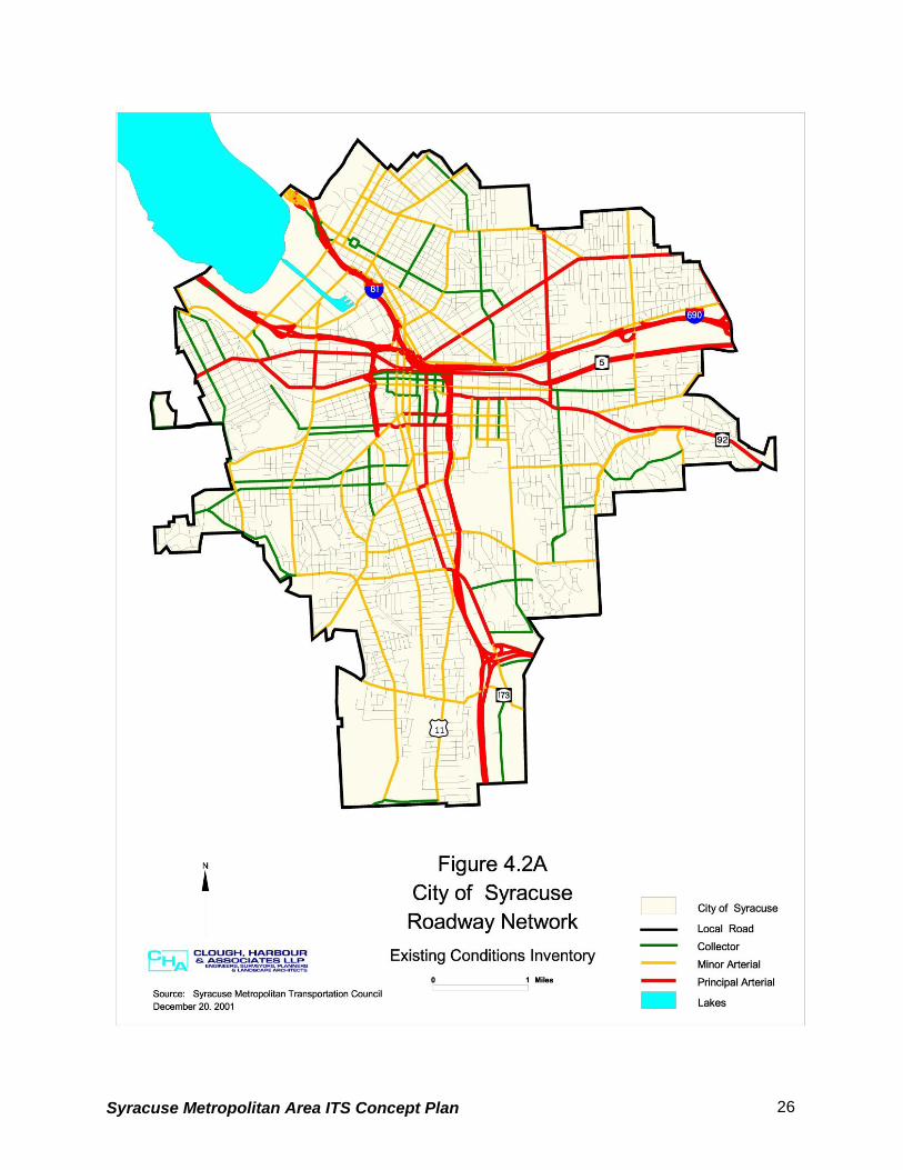
4.2 ROADWAY SYSTEMS.................................................................................... 22 4.2.1 Roadway Network ........................................................................... 22 4.2.2 General Roadway Congestion......................................................... 23 4.2.3 Recurring Congestion...................................................................... 24 4.2.3.1 Congested Road Segments........................................................... 24 4.2.3.2 Congested Intersections ................................................................ 29 4.2.4 Special Event Access Roadways .................................................... 29 4.2.4.1 New York State Fairgrounds .......................................................... 29 4.2.4.2 Carrier Dome.................................................................................. 32 4.2.4.3 Clinton Square ............................................................................... 32 4.2.5 Regional Traffic Generators ............................................................ 33 4.2.6 High Accident Locations .................................................................. 33 4.2.6.1 State Highway System................................................................... 33 4.2.6.2 Local Roadway System.................................................................. 39 4.2.7 Critical Ramp Locations................................................................... 41 4.2.8 Overhead Bridges with Low Clearances ......................................... 41 Table 8 - Low Clearance Bridges .............................................................. 43 4.2.9 Highway-Rail Grade Crossings ....................................................... 45 4.2.10 Major Truck Routes ........................................................................ 47 Town of Camillus ....................................................................................... 47 Town of Dewitt ........................................................................................... 48 Town of Salina ........................................................................................... 49 Village of Liverpool .................................................................................... 49 Permitted Routes ....................................................................................... 49 Restricted Routes ...................................................................................... 50
Syracuse Metropolitan Area ITS Concept Plan
Minor Town and Village Route Restrictions............................................... 50 Table 13 - Minor Town and Village Route Restrictions.............................. 50 4.2.11 Weather Related Transportation Issues ......................................... 50
4.3 TRANSIT AND AIR SYSTEM ........................................................................... 55 4.3.1 Rail Network .................................................................................... 55 4.3.2 Bus Service ..................................................................................... 58 4.3.3 Air Service ....................................................................................... 60
4.4 EXISTING AND PLANNED ITS INVENTORY ..................................................... 62 4.4.1 City of Syracuse .............................................................................. 62 4.4.1.1.Existing ITS Elements.................................................................... 62 4.4.1.2 Proposed ITS Elements ................................................................. 64 4.4.2 Onondaga County ........................................................................... 64 4.4.2.1 Onondaga County Department of Transportation Proposed ITS
Elements ........................................................................................ 64 4.4.2.2 Onondaga County Dept. of Emergency Communications
Proposed ITS Elements ................................................................. 64 4.4.3 New York State Department of Transportation (NYSDOT) ............. 67 4.4.3.1 Existing ITS Elements .................................................................... 67 4.4.3.2 Proposed ITS Elements ................................................................. 72 4.4.4 Central New York Regional Transportation Authority (CNYRTA).... 73 4.4.4.1 Existing ITS Elements .................................................................... 73 4.4.4.2 Proposed ITS Elements ................................................................. 73 4.4.5 Existing Traffic Management Centers ............................................ 74 4.4.6 Existing Communication System ................................................. 76
5. MARKET PACKAGES .............................................................................................. 81 5.1 NATIONAL ITS ARCHITECTURE MARKET PACKAGES ....................................... 81 5.2 SYRACUSE METROPOLITAN AREA ITS STRATEGIC PLAN MARKET PACKAGE
DEFINITIONS................................................................................................ 85 5.2.1 Archived Data ................................................................................... 87 5.2.2 Advanced Public Transportation Systems ........................................ 87 5.2.3 Advanced Traveler Information Systems.......................................... 90 5.2.4 Advanced Traffic Management Systems .......................................... 92 5.2.5 Advanced Vehicle Safety Systems ................................................... 99 5.2.6 Commercial Vehicle Operations ...................................................... 101 5.2.7 Emergency Management ................................................................ 103
5.5 MARKET PACKAGE PLAN DEVELOPMENT ...................................................... 128 5.6 PROCESS OF MARKET PACKAGE PRIORITIZATION ......................................... 129 5.7 SUMMARY OF THE MARKET PACKAGES RATINGS .......................................... 135 5.8 NEXT STEPS................................................................................................ 136
7 FUNDING................................................................................................................... 152 7.1 CAPITAL FUNDING FOR ITS .......................................................................... 153 7.2 OPERATIONS AND MAINTENANCE FUNDING FOR ITS ..................................... 153 7.3 PRIVATE SECTOR FUNDING.......................................................................... 154
Syracuse Metropolitan Area ITS Concept Plan
1. Introduction
1.1 General Background
The New York State Department of Transportation (NYSDOT) has retained PB Farradyne to
develop a strategic plan for deployment of Intelligent Transportation Systems (ITS) for the
Syracuse Metropolitan Area (Onondaga County). PB Farradyne, in its efforts to develop the
plan, is being assisted by Clough, Harbour & Associates, LLP and Howard/Stein-Hudson
Associates, Inc. This technical memorandum is one of a series of reports being prepared for
the strategic plan which will document the established goals, assess operational deficiencies,
analyze the existing conditions of transportation facilities, prioritize those facilities for potential
ITS deployment, and prioritize the ITS Market Packages needs of each involved agency and the
region. This effort considers the near, mid and long term needs of the area.
Onondaga County, with an area of approximately 800 square miles, contains the fourth largest
upstate city (Syracuse) in New York. Onondaga County and the City of Syracuse occupy a
central position within the local, regional, and national transportation system. The region’s
roadways, public transportation, rail, and airport provide outstanding access to services and
employment. In Onondaga County, two major interstates (Interstate 81, which provides
connections to the north and south and the New York State Thruway - Interstate 90, which
provides access to the east and west) meet in Onondaga County and provide access to all of
the Northeast and Canada. In addition, the I-690 runs through the City connecting east to the
west. There are approximately 3,100 miles of roadway and almost 500 bridges in Onondaga
County. However, in some cases, connections among these facilities, and between these
facilities and the local road network, is limited. There are some gaps in the transportation
system, and some facilities have reached capacity. Implementation or expansion of Intelligent
Transportation System (ITS) strategies/elements can improve the overall safety and mobility of
Onondaga County as well as of the region.
Syracuse Metropolitan Area ITS Concept Plan 1
1.2 Improving Transportation Through Technology: An Overview of
Intelligent Transportation Systems (ITS)
The current Long-Range Transportation Plan forecasts that travel times will increase extensively
in the next several years. Therefore, the demand for more traffic capacity will continue to
increase. In addition, more traffic volume translates into an increase in accidents. Accidents not
only cause personal injuries and property damage, but also result in long traffic delays.
Traffic delays and other related problems are not new to the Syracuse Metropolitan area. Like
other metropolitan areas have learned in the past few decades, transportation officials realized
that they could not simply build their way out of congestion. New approaches were needed. In
addition to traditional roadway improvements, the NYSDOT responded to the need to improve
regional transportation services by providing funds to develop a Regional ITS Strategic Plan to
set the stage for regional implementation of ITS, coordination among agencies and sharing of
information.
The concepts of ITS incorporate a broad range of technologies that, when integrated, can help
solve many of our transportation problems. ITS technology elements include information
processing, communications, control systems, and electronic field equipment. Applying these
technologies to our transportation system will save lives, save time, and save money. ITS
technology and the application of management and operations strategies allow transportation
system managers to not only respond to capacity issues, but to improve the overall delivery of
transportation services. Some of the types of service improvements ITS enables include:
• Minimizing response time to incidents and accidents through the use of incident
management programs.
• Providing real time traffic information to help motorists avoid congestion.
• Reducing weather related traffic incidents by using Road-Weather Information Systems
(RWIS) to sense and respond to snow and icing more quickly.
• Improving emergency management communications and providing real-time traffic
information to improve emergency vehicle routing.
• Improving on-time performance and security for transit users through the use of automatic
vehicle location systems.
Syracuse Metropolitan Area ITS Concept Plan 2
In addition, ITS can promote inter-agency communication, cooperation and data distribution.
Through ITS, agencies in different jurisdictions can work together to manage the regional
transportation network as a seamless whole. An integrated transportation system, managed and
operated more efficiently through the use of ITS, enhances quality of life through improvements
to motorist safety, promotion of a strong and growing economy and enhancement and
protection of environmental quality. Last, ITS can address the public’s expectations and
demands for service from their government agencies. Technology is now in the hands of the
public, and their expectations for technology to improve all aspects of their daily lives, including
travel, has increased.
1.3 ITS Architecture
A planning-level architecture (as is provided in this report) describes the planned connections
between diverse computerized systems. The connections are defined by the data that flows
between the systems. In addition, standards required to ensure that each computerized system
can understand and communicate data in a uniform fashion are also included in the ITS
architecture.
ITS architectures are important when ITS elements/systems are implemented in an incremental
fashion by multiple agencies. Computer systems are very difficult to modify once they have
been implemented. Extraction of data from a system that is not designed for that purpose can
be very costly. It is often less costly to replace an entire system than it is to reconfigure it for
specific data extraction. With architecture, systems can be designed up front to accommodate
future connections to other computer systems.
The Syracuse ITS Strategic Plan is simply a plan that describes how local agencies will
connect, communicate and coordinate with each other, and also describes how to enhance the
efficiency of various types of transportation systems, and to determine what types of data will
flow across those connections. Where applicable, communications standards for the data are
identified. In addition, the Syracuse ITS architecture contained within the Strategic Plan
describes how the regional partners will use the transmitted data to improve the delivery of
services. Development of this Strategic Plan and ITS Architecture meets Federal requirements
for ITS project funding.
Syracuse Metropolitan Area ITS Concept Plan 3
On January 8, 2001, the Federal Highway Administration (FWHA) rule and Federal Transit
Authority (FTA) policy on ITS Architecture and Standards were published to implement section
5206(e) of the Transportation Equity Act for the 21st Century (TEA-21). The FTA and FHWA
have different processes and procedures for project development. Therefore, the FHWA has
issued a Regulation, and FTA has issued a Policy. The policy language in each document is
consistent and will be carried out in a coordinated fashion, as applicable under FTA and FHWA
project management and oversight procedures. This final rule/policy requires that ITS projects
funded by the Highway Trust Fund and the Mass Transit Account conform to the National ITS
Architecture, as well as to the United State Department of Transportation’s (USDOT) adopted
ITS Standards.
The final rule/policy requires that:
Regions currently implementing ITS projects must have a regional ITS architecture in
place in four years from the effective date or before April 8, 2005. Regions not currently
implementing ITS projects must develop a regional ITS architecture within four years from
the date their first ITS project advances to final design.
ITS projects funded by the Highway Trust Fund and the Mass Transit Account must
conform to a regional ITS architecture.
Major ITS projects should move forward based on a project level architecture that clearly
reflects consistency with the National ITS Architecture. A major ITS project is any ITS
project that impacts regional integration or national interoperability. In other words they are
those ITS projects in a region which are critical to future integration and therefore must be
developed within the framework of an architecture.
Projects must use USDOT adopted ITS standards as appropriate. To date, the USDOT
has not adopted any ITS standards, and a formal rulemaking process will precede any
USDOT ITS standard adoption. The proposed rule does not require replacement of
existing systems or equipment. Applicable ITS standards would be used as new features
and system upgrades are planned with the use of the National ITS Architecture.
Standards are mandated only when they become officially adopted by the USDOT; at this
point the USDOT has not adopted any ITS standards. The USDOT encourages the use of
applicable ITS standards prior to their official adoption, however, as appropriate.
Compliance with the regional ITS architecture will be in accordance with USDOT oversight
and Federal-aid procedures, similar to non-ITS projects.
Syracuse Metropolitan Area ITS Concept Plan 4
The rule includes requirements for both the ITS planning stage, and the project implementation
stage. This report focuses on the planning stage. Per the rule, the regional ITS plan and
architecture shall include, at a minimum, the following:
1. A description of the region;
2. Identification of participating agencies and other stakeholders;
3. An operational concept that identifies the roles and responsibilities of participating
agencies and stakeholders in the operation and implementation of the systems included
in the regional ITS architecture;
4. Any agreements (existing or new) required for operations, including at a minimum those
affecting ITS project interoperability, utilization of ITS related standards, and the
operation of the projects identified in the regional ITS architecture;
5. System functional requirements;
6. Interface requirements and information exchanges with planned and existing systems
and subsystems (for example, subsystems and architecture flows as defined in the
National ITS Architecture);
7. Identification of ITS standards supporting regional and national interoperability;
8. The sequence of projects required for implementation; and,
9. The agencies and other stakeholders participating in the development of the regional
ITS architecture shall develop and implement procedures and responsibilities for
maintaining it, as needs evolve within the region.
This plan is consistent with the requirements of the ITS Architecture rule.
Due to the importance of Regional ITS Architectures, the USDOT invested a significant amount
of money to develop a National ITS Architecture. The National ITS Architecture includes a broad
array of potential ITS applications and data flows. It can be thought of as the “full menu” of ITS.
Each region can start to create an architecture using the National ITS Architecture, by selecting
or modifying the applications and data flows appropriate to their region. In addition, applications
and data flows not on the National menu can be added.
Syracuse Metropolitan Area ITS Concept Plan 5
1.4 Purpose of The ITS Strategic Plan
Incorporating the ITS plans developed in the past and the ITS infrastructure now implemented in
the region, this plan updates past efforts, establishes an integrated/coordinated/multi-agency
Regional Architecture and agency-based ITS implementation plan and responds to two key
factors:
1. Technology changes- Technology is changing at a rapid pace, and will continue to do so
in the foreseeable future. These changes present certain opportunities to the region for
improving the delivery of transportation services. Long-term changes in technology
cannot be predicted. However, short-term innovations, particularly those tested and
proven elsewhere in the U.S., can be specifically incorporated as they meet local needs.
ITS plans must be frequently updated to reflect changes in technology, including
changes that affect cost.
2. Integration- It has always been the intent of the agencies in the region to develop an
integrated ITS infrastructure. That is, each agency should be able to share data with
other agencies that need it, and operations should be accomplished without regard to
jurisdictional boundaries. This plan addresses how systems can be connected to one
another.
1.5 Organization of Chapters:
Chapter 2 details the stakeholder involvement in the project until the development of this report
and also provides an insight of the institutional issues that were identified. Chapter 3 enlists the
vision and goals of this project while Chapter 4 provides the inventory of existing conditions in
the study area. In Chapter 5, the market packages from the National ITS Architecture were
explained in detail along with the process adopted by the Steering Committee (SC) to utilize
them in developing the ITS Architecture. Discussions in Chapter 6 are focused on identifying the
performance criteria for various ITS elements and Chapter 7 exclusively covers the funding
issues and opportunities that are present.
Syracuse Metropolitan Area ITS Concept Plan 6
2. Stakeholder Involvement
2.1 Outreach Plan
The elements of the Outreach Plan are designed to promote a dialog among the various
stakeholders to ensure reaching a consensus for the implementation of ITS projects in the
Syracuse Metropolitan area. The Plan includes:
• Steering Committee
• Stakeholders Database
• Stakeholders Interviews
• Workshops
• Fact Sheets
Steering Committee: The Steering Committee (SC) is comprised of representatives of all key
agencies that are responsible for the implementation of ITS in the Syracuse Metropolitan area.
The responsibilities of the SC include reviewing and commenting on deliverables, establishing
policy guidance for implementing ITS region wide, and maintaining liaison with other
stakeholders.
The core group of the SC, which meets monthly for the duration of the project, includes
representatives from the New York State Department of Transportation, the New York State
Thruway Authority, the Syracuse Metropolitan Transportation Council, the City of Syracuse,
Onondaga County, the New York State Police, the City of Syracuse Police, the Onondaga
County Sheriff’s Office, the County Fire Department, Onondaga County Emergency 911. The
current listing of the Steering Committee members is provided below:
us William Nurk City of Syracuse-PD 315-442-5203 315-442-5249 [email protected] Robin Palmer NYS Police 315-455-2850 315-455-2944 [email protected] Pete O’Conner Syracuse DPW 315-448-8576 315-448-8531 [email protected] Jerry Zell FHWA 518-431-4124 518-431-4121 [email protected] Frank Kobliski CNYRTA 315-442-3344 315-442-3337 [email protected]
(miles) FATAL INJURY PDO TOTAL ACCIDENT TYPES ACTION
1 11 Bailey Rd 0.1 0 23 40 63 Pattern of left turn/head on collisions at signal
Traffic signal adjustments; no projects planned
2 31 Crabtree-Pardee Rd
0.2 0 24 55 79 Patterns of left turn/head on collisions at signalized I-81 ramp intersections and at gas station convenience stores west of Crabtree and east of Pardee Rd
Project to restore skid resistance scheduled for 2002
3 11 E. Circle Drive-Hogan
0.3 0 39 65 104 Pattern of left turn/head on collisions at E. Circle Drive signal
Adjusted traffic signal to protected only phase; considering reducing skew angle of slip ramp from E. Circle Drive to address rear end collisions
4 298 Carrier Circle 0.5 0 44 118 162 Patterns of rear end, merging collisions on all approaches, heaviest recently on 298 EB approach
Project (PIN 310413) scheduled to reduce skew angle and to channelize EB approach
5 11 Elbow Rd 0.1 0 11 17 28 Patterns of rear end collisions at signal
Project completed that reallocated Rt 11 to two lanes with left lanes at intersection; associated sign work included
6 11 Malden-SouthBay Rd
0.6 0 67 131 198 Most accidents in Mattydale Circle; right angles at I-81NB/Rt 11 SB, I-81 NB/Rt 11 NB; rear end collisions at Rt 11 SB/N Concourse and S. Bay Rd
Project completed that included lane additions /reallocations and associated sign work
7 I-81 Salina St-Spencer
0.3 0 31 71 102 Congestion related accidents at/near downtown ramps (mostly rear end and sideswipe collisions)
Ramp metering being considered for NB
8 31 Walmart-SouleRd
0.5 0 32 62 94 Patterns of congestion related rear end collisions
Recent project created 5-lane section from Belgium to Walmart area; right lane constructed on Rt 31 EB at Soule Rd; upcoming Target and Home Depot development will require additional pavement widening to mitigate generated traffic
(miles) FATAL INJURY PDO TOTAL ACCIDENT TYPES ACTION
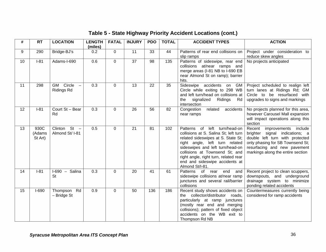
9 290 Bridge-BJ’s 0.2 0 11 33 44 Patterns of rear end collisions on slip ramps
Project under consideration to reduce skew angles
10 I-81 Adams-I-690 0.6 0 37 98 135 Patterns of sideswipe, rear end collisions at/near ramps and merge areas (I-81 NB to I-690 EB near Almond St on ramp); barrier hits.
No projects anticipated
11 298 GM Circle – Ridings Rd
0.3 0 13 22 35 Sideswipe accidents on GM Circle while exiting to 298 WB and left turn/head on collisions at the signalized Ridings Rd intersection
Project scheduled to realign left turn lanes at Ridings Rd; GM Circle to be resurfaced with upgrades to signs and markings
12 I-81 Court St – Bear Rd
0.3 0 26 56 82 Congestion related accidents near ramps
No projects planned for this area, however Carousel Mall expansion will impact operations along this section
13 930C(Adams St Art)
Clinton St – Almond St/ I-81
0.5 0 21 81 102 Patterns of left turn/head-on collisions at S. Salina St; left turn related sideswipes at S. State St; right angle, left turn related sideswipes and left turn/head-on collisions at Townsend St; and right angle, right turn, related rear end and sideswipe accidents at Almond St/I-81.
Recent improvements include brighter signal indications; a double left turn with protected only phasing for SB Townsend St; resurfacing and new pavement markings along the entire section
14 I-81 I-690 – Salina St
0.3 0 20 41 61 Patterns of rear end and sideswipe collisions at/near ramp junctures and several rail/barrier collisions
Recent project to clean scuppers, downspouts, and underground drainage system to minimize ponding related accidents
15 I-690 Thompson Rd – Bridge St
0.9 0 50 136 186 Recent study shows accidents on the collector/distributor roads, particularly at ramp junctures (mostly rear end and merging collisions); pattern of fixed object accidents on the WB exit to Thompson Rd NB
Countermeasures currently being considered for ramp accidents
Syracuse Metropolitan Area ITS Concept Plan 37
Table 5 - State Highway Priority Accident Locations (cont.)
# RT LOCATION LENGTH(miles)
FATAL INJURY PDO TOTAL ACCIDENT TYPES ACTION
16 635 Carrier Circle –Route 298
0.3 0 18 33 51 Past studies showed patterns of rear-end collisions at the signalized carrier driveways; a right angle collision pattern at the McDonald’s entrance, and rear end and merging collisions at Carrier Circle
A recent project on Thompson Rd established a 5-lane section with exclusive left turn lanes at the noted signals; a raised median eliminated left turns out of McDonald’s
17 I-81 LiverpoolInterchange
0.3 1 17 49 67 Concentrations of rear-end and sideswipe collisions on I-81 NB at/near the Liverpool exit and rear end collisions on I-81 SB near the 370/Old Liverpool Rd merges, mainly during peak periods; some icy pavement related accidents on ramp sections
Icy pavement signs in place, and pavement/weather monitor system installed in 1995 No future projects planned, however Carousel Mall expansion will impact this area
18 92 Jamesville Rd– Route 5
0.2 0 8 25 33 Recent study showed patterns of left turn/head on collisions at some of the commercial driveways; previous study showed a left turn/head on pattern at the Jamesville Rd signal.
An upcoming project (PIN 301016) will not include pavement widening on Rt 92
19 930W Westlind – Route 5
0.3 1 15 38 54 Patterns of rear end collisions on Rt 5 slip ramp to 930W WB, right angle collisions at Rt 5 Bypass exit signal, and rear-end and left turn/head-on collisions atWestlind signal.
Work completed includes conversion of yield control on slip ramp to 930W to a stop control, and signal, marking, and lane allocations completed related to Wegmans
20 I-690 I-81/OnondagaInterchange
0.3 0 18 42 60 Patterns of rear-end and sideswipe collisions at/near exit and entrance ramps
Measures to relieve peak hour congestion at I-81 SB/I-690 EB merge have been considered but no projects planned for this section at this time
Source: NYSDOT
Syracuse Metropolitan Area ITS Concept Plan 38
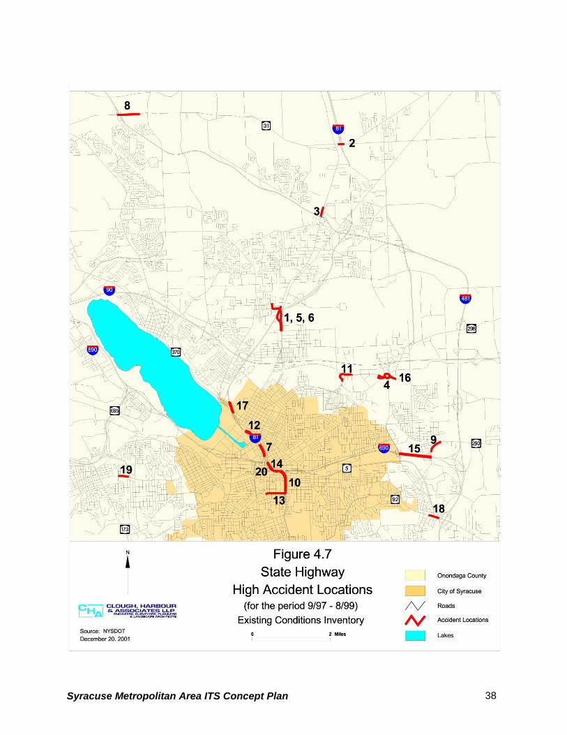
4.2.6.2 Local Roadway System Table 6 lists and Figure 4.8 displays those locations on the local roadway system that had more
than 40 accidents during the years 1997 through 1999. The locations are sorted by the total
number of accidents and do not take in to consideration accident rate or severity. The locations
are numbered for referencing purposes only and are not intended to indicate ranking.
Table 6 - Local Roadway Priority Accident Locations REFERENCE # LOCATION INJURY PDO TOTAL
1 East Adams St/I-81 Underpass 22 55 77 2 Harrison St/I-81 Underpass 19 51 70 3 W Fayette St/West Street Arterial 18 49 67 4 Grant Blvd/Teall Ave 29 37 66 5 N & S Geddes St/Erie Blvd W 24 41 65 6 N Salina St/E & W Genesee St 22 43 65 7 Burnet Ave/Teall Ave 17 48 65 8 N Townsend St/NY 5 19 43 62 9 S Salina St/E & W Seneca Tnpk 18 44 62 10 W Taft Rd/Buckley Rd 17 42 59 11 S Geddes St/W Fayette St 19 37 56 12 E Adams St/Comstock Ave 14 41 55 13 N Geddes St/W Genesee St 19 36 55 14 James St/N State St/E Genesee St 16 35 51 15 Lodi St/James St 23 27 50 16 N McBride St/Erie Blvd E 18 32 50 17 Midland Ave/W Brighton Ave 18 30 48 18 S Salina St/Brighton Ave E & W 18 29 47 19 Butternut St/Lodi St 19 27 46 20 W Hiawatha Blvd/Solar St 17 28 45 21 W Hiawatha Blvd/State Fair Blvd 13 31 44 22 Seymour St/S Geddes St 16 28 44 23 N Geddes St/W Belden Ave 20 23 43 24 Burnet Ave/S Midler Ave 8 34 42 25 James St/Teall Ave 16 26 42 26 E Colvin St/S State St 14 27 41
Source: SMTC, NYSDOT
Syracuse Metropolitan Area ITS Concept Plan 39
Syracuse Metropolitan Area ITS Concept Plan 40
4.2.7 Critical Ramp Locations
Based on input from regional stakeholders there are six off-ramps from interstate highways that
have a significant traffic impact on the local streets. The locations are listed in Table 7 and are
shown in Figure 4.9.
Table 7 - Critical Ramp Locations
Interstate Ramp
I-690 Eastbound off ramp at W. Genesee Street
I-81 Southbound off ramp at Clinton Street/Salina Street
I-690 Westbound off ramp at Townsend Street
I-81 Southbound off ramp at Harrison Street
I-81 Northbound off ramp at Adams Street
I-481 Southbound off ramp at exit 3E (Routes 5 and 92)
The off ramps at Clinton Street, Harrison Street, and Adams Street were also identified as
experiencing significant traffic increases during special events at the Carrier Dome and Clinton
Square.
4.2.8 Overhead Bridges with Low Clearances
The NYSDOT considers overhead bridges with a vertical clearance of less than 14 feet to be
substandard. Table 8 identifies sixteen bridges in Onondaga County that are posted for
substandard vertical clearance. The locations are shown in Figure 4.10.
The Route 20 bridge over Route 11A, referenced as number 1, is currently being reconstructed
and will not have substandard vertical clearance when completed.
Based on local knowledge, the CSX railroad bridge over Route 370 and the NYS&W railroad
bridge over W. Genesee Street, referenced as numbers 8 and 15, respectively, are hit most
frequently.
Syracuse Metropolitan Area ITS Concept Plan 41
Syracuse Metropolitan Area ITS Concept Plan 42
Table 8 - Low Clearance Bridges
REFERENCE
NUMBER
FEATURE CARRIED FEATURE CROSSED ACTUAL CLEARANCE
1 Route 20 Route 11A 13’ 6”
2 Interstate 81 Webb Road 13’ 6”
3 SB West Street Arterial West Genesee 13’ 9”
4 NB West Street Arterial West Genesee 13’ 9”
5 Ramp to Route 690 EB Catherine Street 13’ 9”
6 Finger Lakes Railway Genesee Street 12’ 8”
7 CSX Transport/Amtrak Route 11 13’ 9”
8 CSX Transport Route 370 12’ 03”
9 CSX Transport Route 370/Park
Street
11’ 09”
10 NYS&W Eager Road CR 232 12’ 02”
11 Allied Chemical County Road
6/North Street
12’ 00”
12 NYS&W Route 5 12’ 02”
13 NYS&W W Fayette Street 13’ 04”
14 NYS&W S Geddes Street 13’ 08”
15 NYS&W W Genesee Street 13’ 03”
16 NYS&W Siding W Fayette Street 13’ 08”
Source: NYSDOT
Syracuse Metropolitan Area ITS Concept Plan 43
Syracuse Metropolitan Area ITS Concept Plan 44
4.2.9 Highway-Rail Grade Crossings Table 9 lists and Figure 4.11 displays nine priority highway-rail grade crossing locations. The
first four locations listed are on the Chicago Main Line and were selected due to the frequency
and speed of trains at the crossings. All four locations have a frequency of 70 trains per day
with a maximum train speed of 79-Miles per Hour (MPH). If the state implements high-speed
rail as proposed, these sites will require an additional track for that purpose.
The remaining five sites each have Average Annual Daily Traffic (AADT) volumes greater than
5,000, have a frequency of between five and eight trains per day and a maximum train speed of
40 MPH.
All nine locations are equipped with gates and flashers. The only accident recorded at any of
the sites during the past ten years was a fatality in June of 2000 at the Herman/DeVoe grade
crossing. Motorists driving around lowered gates have been identified as an issue at some of
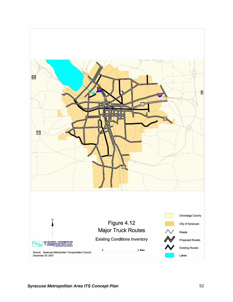
The City of Syracuse Truck Route Study completed by the SMTC in May 2000 documented
existing truck routes within the City of Syracuse and made recommendations for creating one
new route while eliminating others. Figure 4.12 shows the existing truck routes within the City
and displays the changes recommended in the City of Syracuse Truck Route Study. All
highways in Onondaga County owned by the NYSDOT are open to all legal vehicles.
The Onondaga County Department of Transportation cannot legally post truck routes. The
County can post “No Truck” signs; however, since the towns have the authority to post truck
routes, it is the County’s policy to defer to the towns in the placement of “No Truck” signs.
The SMTC requested information from towns in Onondaga County regarding truck routes and
posted weight-restricted routes. The information that was received is summarized below.
Town of Camillus
Restricted Routes
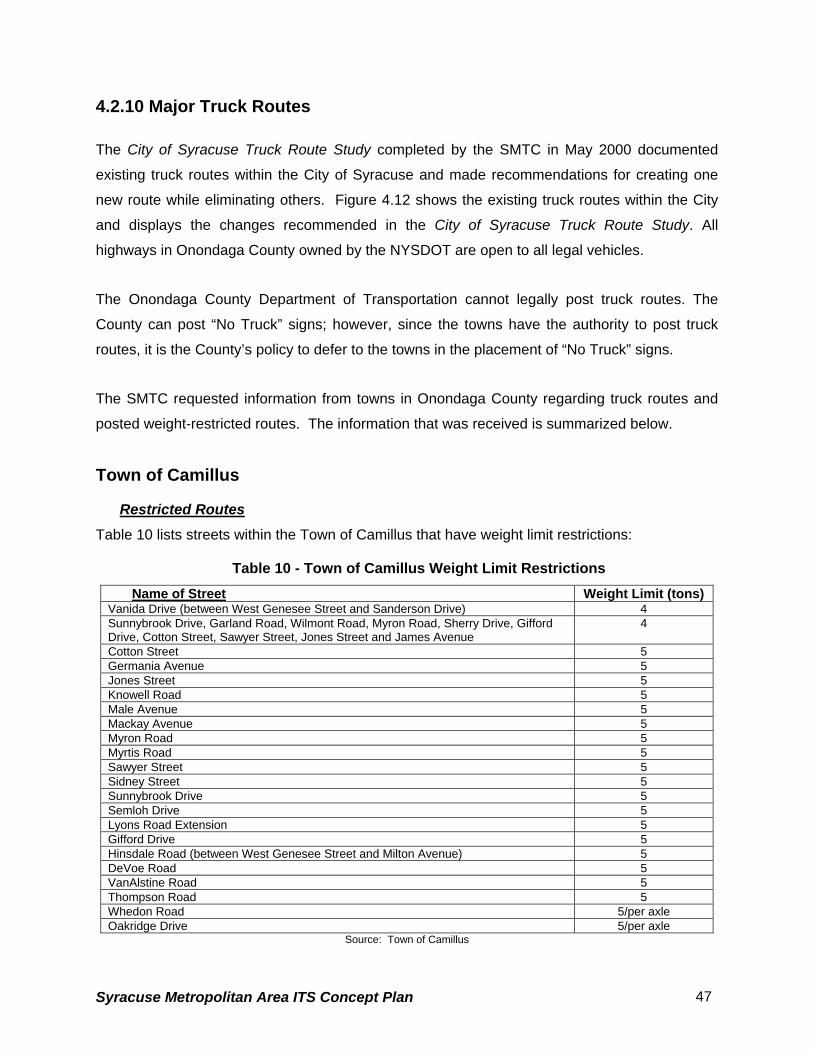
Table 10 lists streets within the Town of Camillus that have weight limit restrictions:
Table 10 - Town of Camillus Weight Limit Restrictions Name of Street Weight Limit (tons)
Vanida Drive (between West Genesee Street and Sanderson Drive) 4 Sunnybrook Drive, Garland Road, Wilmont Road, Myron Road, Sherry Drive, Gifford Drive, Cotton Street, Sawyer Street, Jones Street and James Avenue
4
Cotton Street 5 Germania Avenue 5 Jones Street 5 Knowell Road 5 Male Avenue 5 Mackay Avenue 5 Myron Road 5 Myrtis Road 5 Sawyer Street 5 Sidney Street 5 Sunnybrook Drive 5 Semloh Drive 5 Lyons Road Extension 5 Gifford Drive 5 Hinsdale Road (between West Genesee Street and Milton Avenue) 5 DeVoe Road 5 VanAlstine Road 5 Thompson Road 5 Whedon Road 5/per axle Oakridge Drive 5/per axle
Source: Town of Camillus
Syracuse Metropolitan Area ITS Concept Plan 47
Town of Dewitt
Permitted Routes
The following roads are designated truck routes:
• Cedar Bay between Kinnie Road and Towpath Road
• Kinnie Road west from Agway Drive to Erie Boulevard
• Lapage Place from Walter Drive to Leo Avenue to James Street
Restricted Routes
Table 11 lists streets within the Town of Dewitt that have weight limit restrictions:
Table 11 - Town of Dewitt Weight Limit Restrictions
Name of Street Weight Limit (tons)
Ambergate Road 4 Bradford Drive 5 Bradford Heights Road 5 Butternut Drive (from East Genesee Street to Kinne Road) 4 Canterbury Road 4 Collamer Drive 4 Cross Road 5 DeWittshire Road 4 Franklin Park Drive 4 Grover Street 4 Hobson Avenue 8 Kinne Road (from Mapleview Road to Butternut Drive) 5 Kittel Road 8 Loucks Road 5 Lyndon Road (from East Genesee Street to Kinne Road 4 Orville-Jamesville Road No. 7 (from East Genesee to County Jamesville-Dewitt Interstate Route 281 4
Orvilton Drive (from Thompson Road to East Genesee Street 5 Peck Hill Road (from Nottingham Road to Tecumseh Road 5 Radcliffe Avenue (from Thompson Road to Syracuse City line) 4 Randall Road (from Kimber Road to Jamesville Road 5 Roby Avenue (from James Street to Grover Street) 4 Russell Lane 5 Schuyler Road 5 Scott Avenue 5 Syracuse-Dewitt County Road No. 6 (from Ogle Road to Rams Gulch Road) 5 Tecumseh Road (from Nottingham Road to Kimber Road) 5 Temple Drive 5 Thompson Road (from Kinne Road to Orvilton Drive 5 Warwick Road 4 Wellington Road (from 198 feet south of East Genesee Street south to its terminus) 4 Winchester Road (from Kinne Street to Franklin Park Drive 4 Woodchuck Hill Road (from Marmot Circle east to the Town of Manlius line) 5
Source: Town of Dewitt
Syracuse Metropolitan Area ITS Concept Plan 48
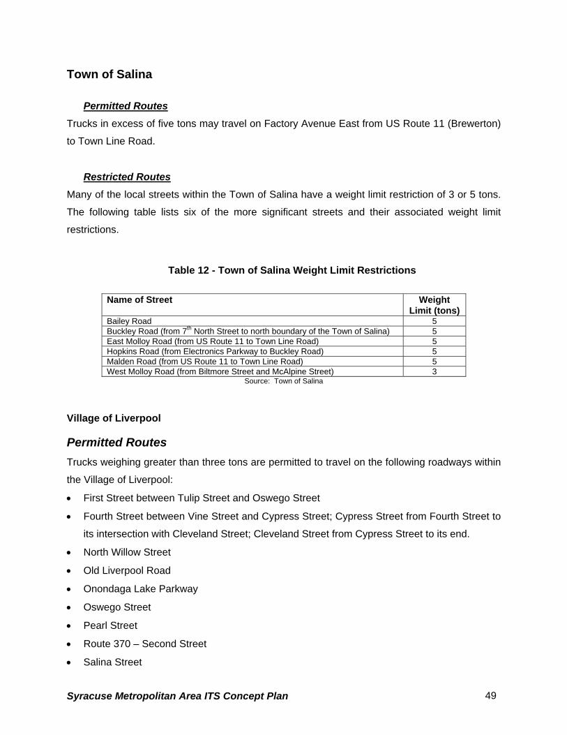
Town of Salina
Permitted Routes
Trucks in excess of five tons may travel on Factory Avenue East from US Route 11 (Brewerton)
to Town Line Road.
Restricted Routes
Many of the local streets within the Town of Salina have a weight limit restriction of 3 or 5 tons.
The following table lists six of the more significant streets and their associated weight limit
restrictions.
Table 12 - Town of Salina Weight Limit Restrictions
Name of Street Weight
Limit (tons) Bailey Road 5 Buckley Road (from 7th North Street to north boundary of the Town of Salina) 5 East Molloy Road (from US Route 11 to Town Line Road) 5 Hopkins Road (from Electronics Parkway to Buckley Road) 5 Malden Road (from US Route 11 to Town Line Road) 5 West Molloy Road (from Biltmore Street and McAlpine Street) 3
Source: Town of Salina
Village of Liverpool
Permitted Routes Trucks weighing greater than three tons are permitted to travel on the following roadways within
the Village of Liverpool:
• First Street between Tulip Street and Oswego Street
• Fourth Street between Vine Street and Cypress Street; Cypress Street from Fourth Street to
its intersection with Cleveland Street; Cleveland Street from Cypress Street to its end.
• North Willow Street
• Old Liverpool Road
• Onondaga Lake Parkway
• Oswego Street
• Pearl Street
• Route 370 – Second Street
• Salina Street
Syracuse Metropolitan Area ITS Concept Plan 49
• Tulip Street
• Vine Street
Restricted Routes Trucks weighing greater than three tons are excluded from all other village streets and all trucks
are excluded from Brow Street between Sycamore Street and Tulip Street.
Minor Town and Village Route Restrictions
Table 13 presents the remaining information that was received from towns and villages
regarding route restrictions.
Table 13 - Minor Town and Village Route Restrictions
Town/Village Name of Roadway Weight Limit
Village of Fayetteville Sheffield Lane 7,000 pounds
Village of Manlius All non-state highways and roads 5 tons Village of Marcellus South Street 5 tons
Village of Tully Railroad Street; Lincoln Street No through truck traffic
Town of Cicero East West Road (between Route 11 and East Circle Road); Lombardi Manor development tract 8,000 pounds
Town of Clay Soule Road 4 tons Town of Spafford All town roads No restrictions
Source: Towns and Villages identified in table
4.2.11 Weather Related Transportation Issues Due to Onondaga County’s geographic location, it is impacted by severe weather conditions
during the winter months including Lake Effect snow. The ITS Strategic Plan Steering
Committee identified the entire county as being subject to weather related transportation issues.
The following four sites were identified by the NYSDOT as locations where the weather has a
significant impact on transportation (see Figure 4.13):
1. Interstate 690 westbound ramp to Auburn
2. Route 695 over the railroad near the New York State Fairgrounds
3. Interstate 81 over Park Street
4. Interstate 81 over Route 80 in Tully
Syracuse Metropolitan Area ITS Concept Plan 50
The NYSDOT has installed Road Weather Information Systems (RWIS) at these locations. A
RWIS is a system developed from a combination of technologies that uses historic and current
climatological data to develop road and weather information to aid in roadway-related decision
making.
Syracuse Metropolitan Area ITS Concept Plan 51
Syracuse Metropolitan Area ITS Concept Plan 52
Syracuse Metropolitan Area ITS Concept Plan 53
There are three components to a RWIS including an environmental sensor system to collect
data, a model or processing system to develop forecasts and provide the information in an
understandable format, and a dissemination platform to display the information.
Syracuse Metropolitan Area ITS Concept Plan 54
4.3 TRANSIT AND AIR SYSTEM
Public transportation services in Onondaga County are primarily provided by the following:
• Centro- a subsidiary of the Central New York Regional Transportation Authority (CNYRTA)
providing fixed route local, express and regional bus service
• OnTrack - local passenger rail service
In addition to the local service, Greyhound and Amtrak provide intercity bus and rail services.
The transportation hub for the intercity services is located at the William F. Walsh Regional
Transportation Center (RTC) shown on Figure 4.14.
4.3.1 Rail Network
The study area passenger rail network consists of the Chicago Main Line owned by CSX
Transportation and the New York Susquehanna & Western Railway (NYS&W) of which OnTrack
is a subsidiary. The overall rail network for the county and the boarding platform locations for
OnTrack are shown in Figure 4.14.
OnTrack provides passenger rail service between Carousel Center Mall and the University area
with additional boarding platforms located at Armory Square and East Colvin Street. There are
also boarding platforms located south of the City in the Town of Jamesville and Jamesville
Beach. These sites are used seasonally for special events such as fall foliage trips.
An additional boarding platform is located at P&C Stadium just beyond the RTC, but service to
this location has been delayed due to the need for a new rail bridge over Park Street. It is
anticipated that this situation will be remedied within the next few years which will allow OnTrack
to provide service to the RTC and P&C Stadium.
OnTrack service is divided into three categories that consist of City Express, Orange Express,
and Special Events with a total annual ridership of 25,000. City Express is the regularly
scheduled service that runs between Carousel Center Mall and the University area and
accounts for approximately 50 percent of annual ridership. The Orange Express provides
service between Carousel Mall and the University for special events at the Carrier Dome. The
Syracuse Metropolitan Area ITS Concept Plan 55
Orange Express combined with other Special Event service accounts for the remaining 50
percent of ridership.
The City Express service operates Wednesday through Sunday from September through May.
The service provides eight daily round trips between 11:00 AM and 7:00 PM. During the
summer months when the Universities are not in session, the City Express only operates Friday
through Sunday. The fair for the City Express is $1.50 per boarding. The Orange Express
service that runs for special events at the Carrier Dome cost $3.00 round trip from Armory
Square and $4.00 round trip from Carousel Center Mall.
Syracuse Metropolitan Area ITS Concept Plan 56
Syracuse Metropolitan Area ITS Concept Plan 57
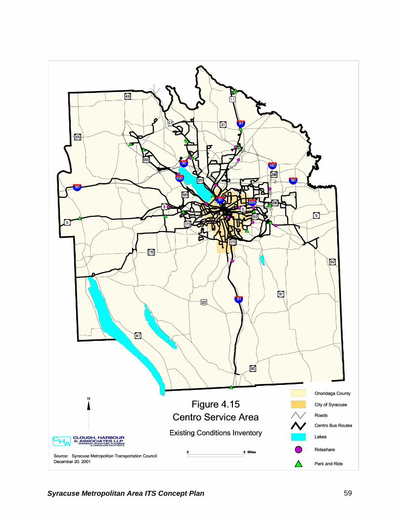
4.3.2 Bus Service The Central New York Regional Transportation Authority (CNYRTA) serves Onondaga, Cayuga,
and Oswego Counties. The CNYRTA has a fleet size of 207 vehicles and serves an area with a
population of 657,715. Approximately 4,000 daily trips are generated with a daily ridership of
41,000 people. Annual passengers total 13,316,428.
The CNYRTA provides for a number of transportation services including:
• Local, handicap accessible service
• Shopper shuttles
• Paratransit services
• Inter-city services between the cities of Auburn, Oswego, Fulton, and Syracuse
• Parking
• Carpool program
• Carrier Dome special events services
• Syracuse and SUNY Oswego shuttle services
A subsidiary of the CNYRTA commonly known as Centro, operates 12 numbered route groups
providing local and express bus service in Onondaga County. With the exception of route group
12, which provides service within the Syracuse University vicinity, all routes converge at
Common Center in downtown Syracuse where transfers can be made conveniently.
As a result of ReMAP (Regional Mobility Action Plan), a recently completed comprehensive
strategic plan for restructuring its public transportation services in Onondaga County, Centro
recently implemented two new routes, the Suburban East Loop and the Suburban West Loop.
The goal is to serve employment, shopping and activity centers while providing convenient
transfers to bus lines serving downtown Syracuse and other locations. Figure 4.15 shows the
areas served by current Centro routes.
Syracuse Metropolitan Area ITS Concept Plan 58
Syracuse Metropolitan Area ITS Concept Plan 59
4.3.3 Air Service
Syracuse Hancock International Airport, owned and operated by the City of Syracuse, is the
only major airport within the study area. In 1997, Hancock International Airport handled 152,000
flights and serviced 2.1 million people. Six major airlines and seven commuter airlines provide
air passenger service. In addition, six major air cargo carriers serve the County.
Syracuse Hancock International Airport is within a fifteen-minute drive of the City of Syracuse
Central Business District (CBD) and within five minutes of the crossroads of Interstates 81 and
90. Access to the airport, shown in Figure 4.16, is obtained via Interstate 81 and South Bay
Road. Access for commercial operations is also displayed.
Syracuse Metropolitan Area ITS Concept Plan 60
Syracuse Metropolitan Area ITS Concept Plan 61
4.4 EXISTING AND PLANNED ITS INVENTORY
This chapter provides an inventory of existing and planned ITS devices/systems based on
information available from various reports as well as information provided by the regional
stakeholders.
4.4.1 City of Syracuse
4.4.1.1. Existing ITS Elements
The City of Syracuse has implemented the following ITS projects (see Figure 4.17):
• Closed Loop Traffic Signal Systems 1. East Genesee Street from Columbus Avenue to Salt Springs Road
2. James Street from Shotwell Avenue to the City line
3. Seventh North Street from Court Street to Crouse Hinds parking lot (just past Hiawatha
Boulevard
4. Burnet Avenue from Catherine Street to Beech Street
5. West Genesee Street from Leavenworth to Avery Avenue
6. Geddes Street from Belden to Delaware Street
• Computer Controlled Traffic Signal Interconnect System: 143 intersections within the
City of Syracuse are currently under computer control. These signals are operated by the
City of Syracuse and connected to the Traffic Control Center (TCC) at the Department of
Public Works using multi-mode fiber optic cable. Figure 4.17 displays the locations of
intersections that are part of the traffic signal interconnect system.
• CCTV (Closed Circuit Television): The City currently has CCTV cameras installed at the
five intersections listed below. The CCTVs allow the City to visually monitor traffic conditions
at these locations from the TCC.
Syracuse Metropolitan Area ITS Concept Plan 62
Syracuse Metropolitan Area ITS Concept Plan 63
1. I-690 westbound off ramp / Townsend Street
2. Harrison Street / Irving Avenue
3. Harrison Street / Almond Street
4. Harrison Street / Montgomery Street
5. Adam Street / McBride Street
4.4.1.2 Proposed ITS Elements
The City of Syracuse has scheduled the following ITS improvements:
• Computer Controlled Traffic Signal Interconnect Project: Expansion of the traffic signal
interconnect system to include the Geddes Street - West Genesee Street loop which
includes 23 intersections is scheduled to begin design in 2004/2005. In addition, the design
for the inclusion of 15 additional intersections in the vicinity of N. Salina Street and Lodi
Street is scheduled for 2004/2005. The locations of the traffic signal interconnect system
expansion are shown in Figure 4.17. The City plans to have all of the traffic signals in the
City included in the interconnect system within the next ten years.
4.4.2 Onondaga County
4.4.2.1 Onondaga County Department of Transportation Proposed ITS Elements
The Onondaga County Department of Transportation currently does not own or operate any ITS
devices. However, the County does have plans to implement the following ITS system in 2002
(see Figure 4.18):
• A closed loop traffic signal system on Route 57 between the Interstate 90 (Thruway)
interchange and Gaskin Road (south of Route 31).
4.4.2.2 Onondaga County Dept. of Emergency Communications Proposed ITS Elements
Syracuse Metropolitan Area ITS Concept Plan 64
The Onondaga County Department of Emergency Communications (911 Center) recently
contracted to upgrade their equipment in order to accept Phase 1 and 2 wireless
communications service (enhanced wireless 911 system). The equipment upgrade is
scheduled for completion in the spring of 2002. Phase 1 wireless service would present 911
workers with digital and graphic information regarding the distressed callers wireless phone
numbers, what tower the signal is coming from and from which direction the signal hit the tower.
Phase 2 wireless service would provide the longitude and latitude of the calling party and
display the information graphically. Currently, there is no anticipated time frame in which phase
2 wireless service will be available.
In addition, the 911 Center has recently agreed to participate in trials for Automatic Crash
Notification (ACN) which uses wireless communication to send emergency information directly
to emergency centers.
Syracuse Metropolitan Area ITS Concept Plan 65
Syracuse Metropolitan Area ITS Concept Plan 66
4.4.3 New York State Department of Transportation (NYSDOT)
4.4.3.1 Existing ITS Elements The NYSDOT currently owns and operates the ITS devices listed below (see Figure 4.19):
• Permanent Variable Message Signs (VMS) 1. I-81 NB north and south of Route 31
2. I-81 SB north of Court Street
• Portable Variable Message Signs (VMS)
• The Onondaga East and West Maintenance Residencies have a total of ten portable
Variable Message Signs (VMS).
• Video Traffic Detection 1. Intersection of Routes 635 & 290 (Thompson Road/James Street)
• Closed Loop Signal Systems 1. Routes 5/92 – Lyndon Corners – Three signals
2. Route 11 – North Syracuse – Four signals
3. Route 31/Route 57 – Moyers Corners – Two Signals
4. Route 31 – Great Northern Mall – Eight Signals
5. Bridge Street – East Syracuse – Six Signals
6. Thompson Road – Dewitt – Eight Signals
7. Fairmount – Four Signals
8. Liverpool – Six Signals*
9. Manlius – Six Signals*
10. Route 5 at Fay Road – 1 Signal
11. Route 31 – Cicero – Six Signals*
*Spread Spectrum Radio Installations
Syracuse Metropolitan Area ITS Concept Plan 67
Syracuse Metropolitan Area ITS Concept Plan 68
• Road Weather Information System (RWIS) 1. I-690 WB Ramp to Auburn
2. Route 695 over railroad near State Fairgrounds
3. Interstate 81 over Park Street
4. Interstate 81 over Route 80 – Tully
• Induction Loop Sites: The NYSDOT has a number of induction loop sites that are used to
obtain traffic volume counts on a three year cycle for their Traffic Volume Report (TVR). The
sites are listed in Table 14. The induction loops are primarily installed at high volume
locations and eliminate the need to manually place tubes across the roadway to obtain
traffic volumes.
Five of the sites (noted in Table 14) are continuous count (CC) locations that provide traffic
volume counts 24 hours a day 365 days a year. In addition to these five locations, the Rt.
370 site has been equipped to be, and is used as, a seasonal CC location. A seasonal
restriction to travel speed has been imposed for safety reasons and therefore the NYSDOT
monitors traffic speed at this location during the winter months.
Syracuse Metropolitan Area ITS Concept Plan 69
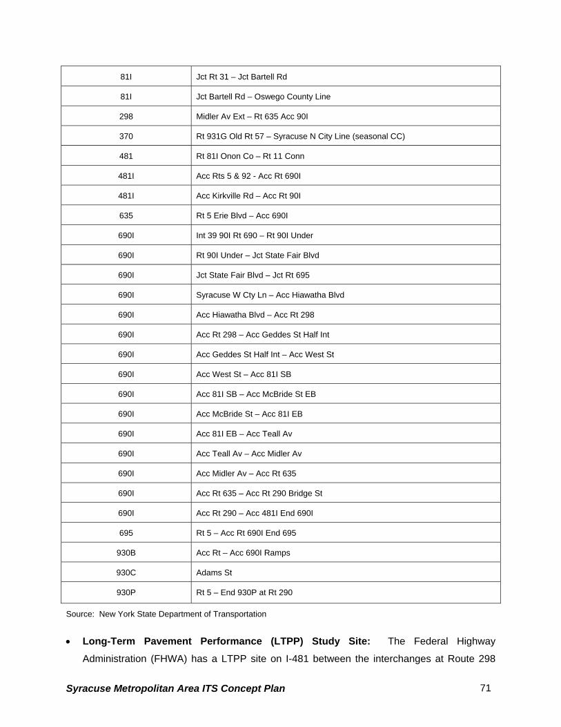
Table 14 - NYSDOT Induction Loop Sites in Onondaga County
ROUTE DESCRIPTION
5 Bennets Corners – Rt 174
5 Rt 174 Camillus – Jct Newport Road
5 Jct Newport Rd – Jct Knowell Rd
5 Jct Knowell Rd – Jct Hinsdale Rd
5 Jct Hinsdale Rd – Acc Rt 173
5 Acc Rt 173 – Acc Rt 695
5 West St Arterial – Rt 11
5 Rt 11 – Rt 635 Syracuse E City Line
5 Rt 635 Syracuse E City Line – Rt 930P Bridge St (CC)
5.2 Syracuse Metropolitan Area ITS Strategic Plan Market Package Definitions
While the Market Packages identified in the national ITS architecture provides a general
framework for developing ITS solutions to transportation problems, their application in a regional
architecture is influenced by the nature of local transportation needs and supporting
infrastructure. Therefore, in adopting the packages in response to the multi-jurisdictional
transportation needs of the Syracuse Metropolitan Area, some revisions to the definition and
service options of some of the national architecture packages were deemed necessary. The
National ITS Architecture is periodically updated with new Market Packages and architecture
flows. This often mandates that agencies revise their regional architectures to keep abreast with
the change in the contents and other core changes mandated by the USDOT. The Architecture
helps ensure that regional ITS deployments are in harmony with national standards.
The pedestrian issues in the Syracuse Metropolitan area were initially suggested for placement
in a new, user-defined market package exclusively to address this issue. After discussions with
the National ITS Architecture experts, it was understood that there is no need to develop an
exclusive market package since there exists an architecture flow in the Physical Architecture to
address the pedestrian needs. The pedestrians are also included as a “terminator”, a
component of the physical architecture in the National ITS Architecture. All of the 63 Market
Packages from the National ITS Architecture were initially considered for the development of the
Syracuse Metropolitan Area ITS Strategic Plan.
Certain Market Packages were found to have no relevance to the regional needs, and hence
were dropped from the finalized list of Market Packages. Except for the following, the core
Market Packages specified by the National ITS Architecture were used to develop this strategic
plan. The revisions are classified as follows:
• Not Used – The Advanced Vehicle Safety Systems (AVSS) Market Packages are
not being considered within this ITS Strategic Plan context because they are not
applicable to the study area’s transportation network goals and they do not fall within
Syracuse Metropolitan Area ITS Concept Plan 85
the realm of the public agencies. These Market Packages are shown shaded in the
above listed table (Table 5.1).
• Fundamental - the market package is recognized as a fundamental building block
for implementation of ITS in the study area. The services offered by the package are
prerequisites to successful and effective operations of many other packages. All
affected agencies shall strive to make funding available for implementation of this
package.
Three Market Packages were identified to belong to this category: the Network
Surveillance (atms01) and the Probe Surveillance (atms02) for traffic management;
and the Transit Vehicle Tracking (apts01) for transit management. • Modified - the market package cvo01, Fleet Administration, is modified to address the
tracking of maintenance and supervisory vehicles of stakeholder agencies. This market
package is actually devised to track the movement of commercial vehicle fleet. But due
to the inadequacies of the current version of the National ITS Architecture in addressing
this issue, some user-defined flows are created exclusively for this market package to
define tracking of vehicles (snow plows) during emergencies, especially relating to
weather. A new market package called Maintenance and Construction Operations
(MCO) is already recommended for inclusion into the National ITS Architecture and will
find a place in the future updates/revisions of this architecture.
As stated in the National ITS architecture document, the deployment oriented Market Packages
can be traced to the interface-oriented architecture definition. Once a particular market
package is selected for implementation, the required subsystems, equipment packages, and
interface requirements are readily identified due to this traceability. This approach allows the
implementer (and this Implementation Strategy) to first consider service needs and later
concentrate on those pieces of the architecture necessary to provide the selected service.
The following list presents the ITS Strategic Plan deployment Market Packages as they have
been defined to reflect the characteristics of the Syracuse Metropolitan Area.
Syracuse Metropolitan Area ITS Concept Plan 86
5.2.1 Archived Data
1. ITS Data Mart (ad1) This market package provides a focused archive that houses data collected and owned by a
single agency, district, private sector provider, research institution, or other organization. This
focused archive typically includes data covering a single transportation mode and one
jurisdiction that is collected from an operational data store and archived for future use. It
provides the basic data quality, data privacy, and meta-data management common to all ITS
archives and provides general query and report access to archive data users. 2. ITS Data Warehouse (ad2) This market package includes all of the data collection and management capabilities provided
by the ITS Data Mart, and adds the functionality and interface definitions that allow collection of
data from multiple agencies and data sources spanning across modal and jurisdictional
boundaries. It performs the additional transformations and provides the additional metadata
management features that are necessary so that all this data can be managed in a single
repository with consistent formats. The potential for large volumes of varied data suggests
additional on-line analysis and data mining features that are also included in this market
package in addition to the basic query and reporting user access features offered by the ITS
Data Mart.
3. ITS Virtual Data Warehouse (ad3) This market package provides the same broad access to multimodal, multidimensional data
from varied data sources as in the ITS Data Warehouse Market Package, but provides this
access using enhanced interoperability between physically distributed ITS archives that are
each locally managed. Requests for data that are satisfied by access to a single repository in
the ITS Data Warehouse Market Package are parsed by the local archive and dynamically
translated to requests to remote archives which relay the data necessary to satisfy the request.
5.2.2 Advanced Public Transportation Systems 4. Transit Vehicle Tracking (apts1)
This market package provides for an Automated Vehicle Location System to track the transit
vehicle’s real time schedule adherence and updates the transit system’s schedule in real-time.
Vehicle position may be determined either by the vehicle (e.g., through GPS) and relayed to the
Syracuse Metropolitan Area ITS Concept Plan 87
infrastructure or may be determined directly by the communications infrastructure. A two-way
wireless communication link with the Transit Management Subsystem is used for relaying
vehicle position and control measures. Fixed route transit systems may also employ beacons
along the route to enable position determination and facilitate communications with each vehicle
at fixed intervals. The Transit Management Subsystem processes this information, updates the
transit schedule and makes real-time schedule information available to the Information Service
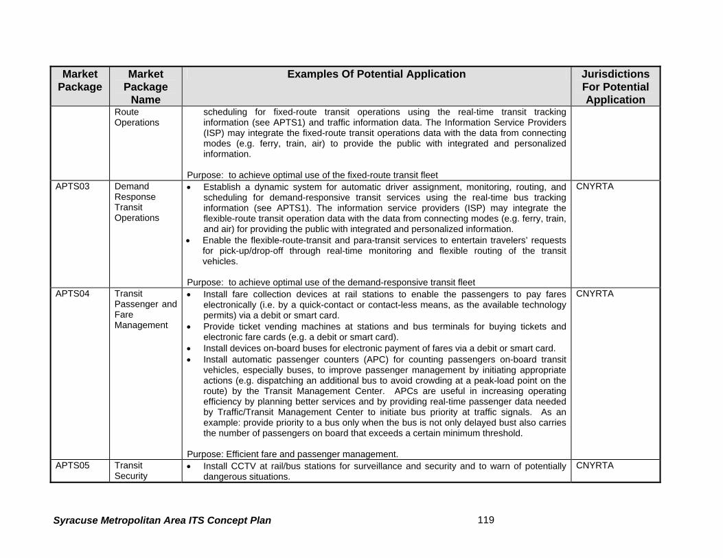
Provider Subsystem via a wire line link. 5. Transit Fixed-Route Operations (apts2)
This market package performs automatic driver assignment and monitoring, as well as vehicle
routing and scheduling for fixed-route services. This service uses the existing AVL database as
a source for current schedule performance data, and is implemented through data processing
and information display at the transit management subsystem. This data is exchanged using the
existing wire line link to the information service provider where it is integrated with that from
other transportation modes (e.g. rail, ferry, air) to provide the public with integrated and
• Increases in speeds, decrease in number of stops for equipped travelers
• Some benefits for non-equipped travelers
• Higher benefits for pre-trip versus en-route information
• Decreasing benefits with higher market penetrations
• Primary value for incident-related (accidents, weather, special events, etc.) traffic delays, across all geographic areas
• Higher benefits to travelers with long trips, multiple mode and route alternatives
• Higher benefits for visitor's and other unfamiliar travelers
Yellow Pages and Reservation
• Potential reduction of VMT spent searching for trip destinations
• Benefits highest for visitors and other unfamiliar travelers
• Familiar travelers benefit from parking reservation
Dynamic Ridesharing • Increased vehicle occupancy and
use of HOV modes • Improved individual mobility
• Significant density of related trips is necessary to ensure ride matching
In Vehicle Signing • Reduction in search time and
excess VMT • Reduction in accidents
• Anticipated benefits in congested areas, night driving, rural areas
• Aid to visually challenged drivers
Syracuse Metropolitan Area ITS Concept Plan 105
Market Packages Likely Benefits Context Where Benefits May Occur
Benefits of Transit Management Market Packages
Transit Vehicle Tracking • Improvement in vehicle on-time
performance • Reductions in field supervision
• Higher benefits to areas with significant transit service reliability problems
Fixed-Route Operations • Improved productivity of vehicles, labor
• All transit scenarios
Demand-Responsive Transit Operations
• Improved productivity of vehicles, labor
• Efficiencies in routing and trip scheduling
• All transit scenarios
Transit Passenger and Fare Management
• Passenger convenience of common fare instrument
• Reduction in cash handling losses • Reduction in costs of data
collection and fare processing
• Benefits clearest where multiple agencies share services, transfers, etc.
Transit Security • Faster response to incidents • Record of security incidents
• High benefits in less secure areas (e.g. large urban areas)
Transit Maintenance
• Effective scheduling of maintenance activities
• Reduction in maintenance and system repair costs
• All transit scenarios
Multi-modal Coordination • Reduction in transit travel times from signal priority
• Good institutional cooperation between traffic and transit managers is necessary
• Level of benefits depends on ambient traffic volumes and cross traffic in selected corridors or in area-wide systems
Transit Traveler Information
• Improved individual mobility • Enhanced attractiveness of
transit as alternative to SOV use • Reduced travel stress due to
knowledge of real time schedules and ability to generate custom itineraries
• Areas with unpredictable system route times and complex service.
Benefits of Traffic Management Market Packages
Network Surveillance • Indirect benefits only • Data support for other ATMS
services
• Essential component for incident detection and sometimes for signal control
• Higher value for regions where traffic pattern are transient and unpredictable
Syracuse Metropolitan Area ITS Concept Plan 106
Market Packages Likely Benefits Context Where Benefits May Occur
Probe Surveillance • Indirect benefits only • Data support for other ATMS
services
• Essential component for incident detection and sometimes for signal control
• Higher value for regions where traffic pattern are transient and unpredictable
Surface Street Control
• Reduction in travel time • Reduction in queue time • Increase in speeds • Reduction in stops • Reduction in fuel consumption • Reductions in VMT • Reductions in HC and CO
emissions • Reduction in intersection-related
accident rates, with higher reductions possible for left-turn accidents
• Significant benefit-to-cost ratio
• Most surface street systems will benefit from this Market Package
• Cities with major traffic generators such as theme park or stadium will benefit more
• It is expected that signal coordination tailored to specific local traffic patterns can have significantly higher benefits.
Freeway Control
• Increase in freeway speed (before-after) during congested peak hours, depending on level of congestion
• Increase in freeway throughput • Reduction in travel time • Reduction in queue time • Reduction in fuel consumption • Reduction in emissions
• Most freeway systems will benefit from this market package
• Essential component for HOV Lane Management and Reversible Lane Management Market Packages
• Capacities of freeway on and off ramps may be diminished by ramp metering
HOV Lane Management
• Reduction in travel time • Increase in lane carrying
capacity • Increase in use of transit and
HOV modes • Reduction in number of
stops (HOV priority at ramp meters)
• Benefits will be greatest in areas with high levels of congestion, concentrated residential and employment land uses, and limited route options.
• Improved service on HOV lanes could induce more HOV travelers and improve flow on non-HOV facilities.
Traffic Information Dissemination
• Positive value but quantitative estimates have yet to be determined
• Regions where travelers respond to traffic information by changing departure time, route choice, etc.
• Regions that have alternate routes, mode choices, etc.
Regional Traffic Control • Uncertain level of benefits, but
can be significant in many instances
• High benefits in regions with many cities or jurisdictions
Incident Management System
• Reduction in incident response times for large urban areas
• FSP programs report significant reductions in incident-related vehicle hours of delay
• Significant benefit to cost ratio
• Regions with high frequency of incidents
• Regions where incident delays constitute a substantial part of delays
Syracuse Metropolitan Area ITS Concept Plan 107
Market Packages Likely Benefits Context Where Benefits May Occur
Traffic Forecast and Demand Management
• Reductions in data collection cost
• Benefits depend heavily on current surveillance and analysis activities
• Regions that have TDM programs • Regions that have traffic
management plans responding to performance evaluation
Electronic Toll Collection
• Reduce peak hour congestion • Reduction in toll plaza operating
costs • Reduced incidents and
emissions
• Regions that have TDM programs or existing manual toll collection systems
• Toll collection infrastructure can be leveraged to provide traffic surveillance capabilities
Emissions monitoring and management • Improve air quality • High value in geographic areas in air
quality non-attainment
Virtual TMC and Smart Probe
• Reduction in incident notification time
• Reduction in infrastructure operating costs
• Support traffic management and traveler information services
• Assumed value in rural and inter-urban areas with low capital
Standard Railroad Grade Crossing Advanced Railroad Grade Crossing
• Some grade crossing accidents may be avoided
• Condition of rail roadside equipment can be monitored
• Requires institutional cooperation between rail operators and traffic managers
Railroad Operations Coordination
• Further contribution to benefits identified under Surface Street Control. Level of benefits unknown
• Larger traffic networks with significant highway-rail intersection closures.
Parking Facilities Management
• Reduction in administrative costs• Reduction in queues at parking
entrances and exits • Can support use of HOV and
transit modes
• Can leverage electronic toll collection equipment
• Most effective when coupled with other urban traveler information services
Reversible Lane Management
• Reduction in travel time • Increase in lane carrying
capacity • Mitigate safety risks with existing
reversible lanes
• Viable in corridors with clear directional patterns or to respond to dynamic demand changes and special events
Road Weather Information System
• Improved safety via valuable pre-trip and en-route information
• Enhanced facility maintenance efficiency
• Especially relevant in rural areas with diverse terrain and variable weather patterns.
Regional Parking Management
• Improved facility utilization • Reduced travel time, fuel use,
and emissions associated with traveler parking services
Fleet Administration • Improvements in vehicle and
driver productivity • Increase in loaded miles
• Local and long-haul systems
Syracuse Metropolitan Area ITS Concept Plan 108
Market Packages Likely Benefits Context Where Benefits May Occur
Freight Administration • Largely unknown level of benefits
• Hazardous materials and other sensitive cargo
Electronic Clearance
• Reduction or elimination of border clearance times
• Reductions in commercial and public administrative costs
• Improvements in vehicle and driver productivity
• Highest benefits for long-haul carriers
Commercial Vehicle Administrative Processes
• Significant cost savings for commercial vehicle operators and regulatory agencies
• Reduced HAZMat incidents • Reduced tax evasion
• Most effective when implemented across jurisdictions.
International Border Electronic Clearance
• Reduction or elimination of border clearance times
• Reductions in commercial and public administrative costs
• Improvements in vehicle and driver productivity
• Highest benefits for long-haul carriers
Weigh-In-Motion
• Reduction in vehicle weighing times
• Reductions in commercial and public administrative costs
• Improvements in vehicle and driver productivity
• Highest benefits for long-haul carriers
Roadside CVO Safety
• Reduction in safety inspection times
• Reduction in commercial vehicle accidents
• The capabilities for performing the safety inspection are shared between this market package and the On-Board CVO Safety Market Package which enables a variety of implementation options
On-board CVO Safety
• Reduction in commercial vehicle accidents
• The capabilities for performing the safety inspection are shared between this market package and the Roadside CVO Safety Market Package which enables a variety of implementation options
CVO Fleet Maintenance
• Improvement in vehicle productivity
• Reduction in commercial vehicle accidents
• All CVO scenarios
HAZMAT Management
• Faster and more appropriate response to HAZMAT incidents
• Reduction in number of accidents
• Requires coordination between fleet administration, traffic management, and emergency management officials.
Benefits of Archived Data Market Package
Syracuse Metropolitan Area ITS Concept Plan 109
Market Packages Likely Benefits Context Where Benefits May Occur
ITS Data Mart
• Largely unknown level of benefits; rarely measured in quantitative terms, however the Archived Data Market Packages improved system planning by reducing sampling biases and providing more detailed data
• Potential reduction in effort required for data collection and analysis for system planning
• Agencies and analysts engaged in detailed modeling / simulation
• Agencies with significant data reporting responsibilities
ITS Data Warehouse
• Largely unknown level of benefits; rarely measured in quantitative terms, however the Archived Data Market Packages improved system planning by reducing sampling biases and providing more detailed data
• Potential reduction in effort required for data collection and analysis for system planning
• Support data integration and multi- variable analyses
• Data standards efforts will have a significant impact on ease of data sharing and integration
• Agencies and analysts engaged in detailed modeling / simulation
• Agencies with significant data reporting responsibilities
ITS Virtual Data Warehouse
• Largely unknown level of benefits; rarely measured in quantitative terms, however the Archived Data Market Packages improved system planning by reducing sampling biases and providing more detailed data
• Potential reduction in effort required for data collection and analysis for system planning
• Support data integration and multi-variable analyses
• Institutional relationships at a regional level must be sufficient to facilitate cooperation between different agencies and jurisdictions
Benefits of Emergency Management Market Packages
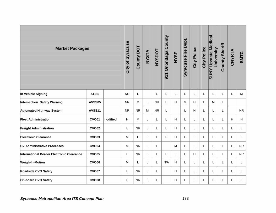
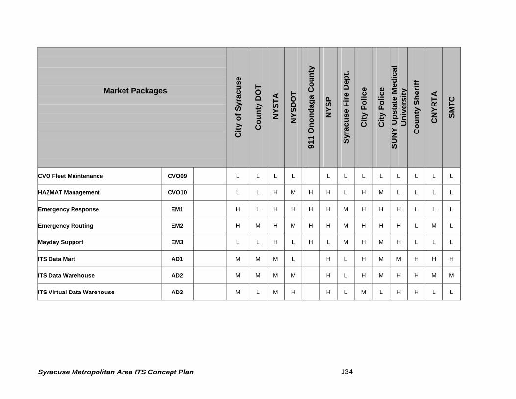
Emergency Response • Assumed reduction in response
times through system-coordinated response
• Higher level of benefit realized in areas with multiple jurisdictions and independent response agencies
Emergency Vehicle Routing
• Unknown level of benefits • Effectiveness can be enhanced with local signal preemption capabilities
Mayday Support
• Anticipated faster routing of calls, shorter response times
• Higher level of benefit realized in areas with multiple jurisdictions and independent response agencies
• High benefits in rural areas Benefits of Vehicle Safety Market Packages
The following Market Packages are primarily aimed towards the private sector (especially automobile manufacturers) and are considered of relatively low applicability to the public sector agencies.
Market Packages Likely Benefits Context Where Benefits May Occur
Driver Safety Monitoring • Lower accident rates due to driver impairment
Longitudinal Safety Warning
• Reduction in backing and rear-end accidents
Lateral Safety Warning • Reduction in lane departure accidents
Intersection Safety Warning
• Difficult to estimate level of reduction of intersection-based accidents
• Some intersection-related accidents may be avoided
• Higher possible value at unsignalized intersections
Pre-Crash Restraint Deployment
• Reduction in accident severity
Driver Visibility Improvement
• Reduction in accidents due to driver vision impairment
• Reduction in night vision impairment accidents
• Higher benefits in night driving, inclement weather
• Significant benefits for visually challenged drivers
Advanced Vehicle Longitudinal Control
• Improvement in highway lane capacity
• Reduction in rear-end and backing accidents with other automobiles
• Reduction in rear-end and backing accidents with fixed objects
• Applications most likely on freeway and other restricted-access roads
Advanced Vehicle Lateral Control
• Reduction in lane departure accidents
• Applications most likely on freeway and other restricted-access roads
Intersection Collision Avoidance
• Unknown level of benefits, difficult to quantity
• Possible high value at unsignalized intersections
Automated Highway System
• Significant improvements in highway lane capacity
• Broad range possible safety and environmental benefits, depending on system design
• Likely scenarios still under discussion
Syracuse Metropolitan Area ITS Concept Plan 111
5.4 Agency Market Package Plans
The Market Package plan for an agency consists of a set of prioritized ITS services carefully
selected with a view to alleviating the existing problems and to achieving overall long-term
objectives of the agency. The importance of the agency-specific market package plan is
stressed by the fact that while the desired functional capabilities of the plan satisfy the agency’s
needs, the plan’s technological interface establishes the framework for the subsequent task of
developing the ITS system architecture for the agency. It allows the agency to concentrate on
those pieces of the architecture necessary to provide the required services. This section
develops market package plans for the transportation related agencies in the study area. These
agencies include:
• New York State Dept. of Transportation (NYSDOT Region 3)
• New York State Thruway Authority (NYSTA)
• New York State Police
• Syracuse Metropolitan Transportation Council (SMTC)
• Central New York Regional Transportation Authority (CNYRTA)
• City of Syracuse Department of Public Works (DPW)
• City of Syracuse Police Department
• City of Syracuse Fire Department
• City of Syracuse Emergency Management Services
• Onondaga County Department of Transportation
• Onondaga County Sheriff’s Office
• Onondaga County 9-1-1
5.4.1 Potential Applications of Market Packages
In subsection 3, a generic description was provided for each market package; however no real-
world applications were discussed. This sub-section simplifies the understanding of each
market package by providing examples of potential applications in terms of deployable projects.
As shown in Table 17, the Network Surveillance (atmsS01) market package will include
deployment of electronic devices such as Close Circuit Television (CCTV), Video Image
Syracuse Metropolitan Area ITS Concept Plan 112
Detectors (VID), and other detectors/sensors on the roadway network for measuring various
performance measures (e.g. speed, volume, vehicle classification, etc.). Similarly the other
Market Packages have potential applications that may relate to transit, commercial vehicles
operations, pedestrian, emergency management and so on. Sometimes two or more Market
Packages are required to achieve a desired function. Table 17 will be used in the subsequent
analyses to identify the priority Market Packages for each agency in the City of Syracuse region.
5.4.2 Priority Rating Definitions The market package plans for the agencies were developed by assigning a priority rating to
each package. With the exception of fundamental/mandatory Market Packages mentioned
earlier, the following priority ratings were used for other Market Packages:
High - the market package offers services that are fundamental to agency’s existing as
well as perceived future operations; a high priority candidate for funding. The agency
will actively pursue financing and implementation of the market package.
Medium - the market package offers services that are only complementary to agency’s
existing as well as perceived future operations; a medium priority candidate for agency
funding. The agency will consider financing it to the extent required to complement the
services of a high priority package.
Low - the market package offers services that are only remotely related to agency’s
existing as well as perceived future operations; a low priority candidate for agency
funding.
Not Rated - the market package offers services that are not related to the agency
operations. It is not a candidate for agency financing.
Syracuse Metropolitan Area ITS Concept Plan 113
This page is intentionally left blank
Syracuse Metropolitan Area ITS Concept Plan 114
Table 17 - Potential Applications of ITS Market Packages1
Market
Package Market
Package Name
Examples Of Potential Application Jurisdictions For Potential Application
ATMS01 NetworkSurveillance
• Install close circuit television (CCTV) cameras, video image detectors (VID), and other detectors for data collection along major City arterials.
• Install close circuit television (CCTV) cameras, video image detectors (VID), and other detectors for data collection along freeways.
• Install road and weather sensors for monitoring ice, snow and rain conditions. Purpose: to measure volume, speed, and travel time; and to detect incidents in real time
City of Syracuse, Onondaga County, adjacent city/ county jurisdictions, NYSDOT, NYSTA
ATMS02 ProbeSurveillance
• Install readers along the toll roads and freeways that use E-ZPass tags for toll collection. • Extend readers to non-toll roads and freeways, provided there are sufficient vehicles with
E-ZPass tags. • Use buses as probes along non-tolled freeways. • Use buses as probes along major City and County arterials. Purpose: to measure volume, speed, and travel time; and to detect incidents in real time.
NYSDOT, NYSTA, County and City
ATMS03 Surface StreetControl
• Install advanced signal controllers and computer controlled signal systems; apply traffic progression and coordination principles along signalized arterials.
• Install adaptive signal control systems, where appropriate, especially at major arterials with sudden surges in traffic pattern.
• Ensure inter-jurisdiction coordination to maintain signal coordination along arterials that traverses multiple jurisdictions.
Purpose: to provide central control of surface street signals; to reduce delay and vehicle emissions; to increase average travel speed by maintaining traffic flow and to increase throughput by utilizing optimum capacity.
City of Syracuse, County arterials,
1 This table is intended to simplify the understanding of ITS Market Packages by providing examples of potential applications. It should be noted that an agency might have already deployed some of the applications listed here. This table might have included those applications too (for the agency, see last column) to make this a comprehensive list. However, this table should not be treated as an all-inclusive list of applications as with innovations in technology there would always be new applications in every group of Market Packages.
Syracuse Metropolitan Area ITS Concept Plan 115
Market Package
Market Package
Name
Examples Of Potential Application Jurisdictions For Potential Application
ATMS04 FreewayControl –Ramp Control
• Install ramp metering at freeway ramps and interchanges, and coordinate ramp control
signals with local street signals Purpose: to maintain optimum traffic flow on freeway and ensure safe merging of on-ramp vehicles.
NYSDOT, NTSYTA
ATMS05/ ATMS17
HOV andReversible Lane Management
• Install cameras/detectors to monitor and enforce bus-HOV lanes on freeways • Install vehicle occupancy detectors along HOV lanes • Install cameras/detectors to monitor and enforce bus lanes on the arterials • Install cameras/detectors on reversible lane facilities and provide provisions for the Traffic
Management Center (TMC) to dynamically mange these facilities, especially during special events or other events that cause traffic surges.
• Install variable speed limit signs along HOV and reversible lanes, as appropriate. Purpose: to increase throughput by effectively managing buses, HOVs, and reversible lanes, especially during peak hours of travel and special events. Ensure safe merging of on-ramp vehicles.
NYSTA- Reversible lanes only at Toll Collection Facilities. No HOV Lanes in the study area.
ATMS06 TravelerInformation Dissemination
• Install variable message signs (VMS) at critical decision points in the freeway and arterial network.
• Install highway advisory radios (HAR) along freeway/arterial networks and at major destinations (e.g. airports)
Purpose: to provide basic traveler information so that the travelers can make an intelligent choice for their travel route and avoid locations of incidents.
NYSDOT, NYSTA, City of Syracuse, Onondaga County.
ATMS07 RegionalTransportation Control
• Install communication links and coordination between traffic control centers of multiple jurisdictions so that: a) Integrated signal control can be established for the arterials that traverse multiple
jurisdictions. b) A single traffic control center can manage the facilities of multiple jurisdictions during
off-peak hours, or during other hours of need.
Purpose: to manage transportation more efficiently through sharing/transferring some of the traffic control functions among two or more jurisdictions.
NYSDOT, NYSTA, City of Syracuse, Onondaga County, Emergency Service Providers
ATMS08 IncidentManagement System
• Install surveillance and data collection systems (see packages ATMS1, ATMS2, ATMS3) to detect and verify incidents
• Install effective communication channels among traffic, police, fire, and emergency
NYSDOT NYSTA, City of Syracuse &
Syracuse Metropolitan Area ITS Concept Plan 116
Market Package
Market Package
Name
Examples Of Potential Application Jurisdictions For Potential Application
management • Establish an effective site management mechanism for quick response to remove
incidents (with on-call tow trucks, strategically located multipurpose help-vehicles or tow trucks, etc.)
• Install strategies to disseminate traveler information about the occurrence of an incident, about expected delays, and to suggest alternate routes (if necessary) via VMS, HAR (see ATMS06), via broadcast radio/television and any other suitable means.
Purpose: to restore traffic flow at optimum level as quickly as possible, and to provide appropriate guidance to travelers so that the impact of the incident is minimized.
Onondaga County – Police, Fire, and Emergency Management Departments, NYSP
ATMS09 TrafficForecast and Demand Management
• Establish a planning process for dynamic modeling of traffic and transit networks to measure demand, capacity and travel speed, to the extent possible, in real-time, and to forecast network performance (travel time, speed, capacity, etc.) by incorporating anticipated demand. The source data are available from traffic/transit management centers, and anticipated route/mode plans may be supplied by information-service-providers (ISP) or MPOs. The network performance evaluation may require the use of advanced algorithms to process a huge amount of data.
• Establish travel demand management (TDM) programs based on the network performance evaluation.
Purpose: to optimize throughput at near real time or for future conditions by devising appropriate Transportation Demand Management (TDM) programs.
MPOs, Agency planning departments, City and County traffic operations centers.
ATMS10 Electronic TollCollection
• Expand the E-ZPass, the electronic toll collection system currently in use at parts of the metropolitan area, to all tolled highways in the area.
Purpose: to increase throughput and reduce congestion at roadway and bridge toll plazas, facilitate fee payment at the parking toll collection booths.
• Install vehicle-emission-sensing detectors at major intersections and at selected highway locations where there is a potential for exceeding the ambient air quality threshold. It may include machine-vision-based equipment to identify potential violators’ license plates for appropriate action.
Purpose: to improve air quality and thus quality of life.
NYSDOT, NYSTA, City of Syracuse, Onondaga County.
ATMS12 Virtual TMCand Smart Probe Data
No mature application is available at this time
Syracuse Metropolitan Area ITS Concept Plan 117
Market Package
Market Package
Name
Examples Of Potential Application Jurisdictions For Potential Application
ATMS13/ ATMS14
Standard/Advanced railroad grade crossing
• Installation of track and road surface sensors and wayside control equipment to detect presence of vehicles on grade crossing.
• Coordinated control between Highway and Railroad operations to avoid any accidents.
City, County and Railroad companies.
ATMS16 Parking FacilityManagement
• Install equipment to assist the management of parking operations, coordinates with transportation authorities, and supports electronic collection of parking fees.
• Provide availability information to travelers through guide signs and coordinated traveler information through ISPs message boards.
Purpose: to facilitate parking availability information and faster electronic toll collection.
City owned and private parking lots.
ATMS18 Road WeatherInformation
• Install sensors to monitor the road surface conditions • Installation of de-icing equipment at bridge and accident prone areas • Install weather sensors that monitor atmospheric weather conditions such as wind speed,
wind chill, direction, etc and can forecast hazardous weather patterns. Purpose: to provide real-time weather information to traffic control centers to manage hazardous weather conditions and propel appropriate response by planning and controlling the inventory of manual labor and materials.
City of Syracuse, Onondaga County, NYSDOT and NYSTA.
ATMS19 RegionalParking Management
• Install electronic toll/fare collection system at park-n-ride lots, airport parking lots/garages, and major parking lots/garages in urban areas.
• Install directional signs and post parking availability information (in real-time) at major intersections and/or decision points in the city, near park-n-ride lots, and in the vicinity of major destinations.
Purpose: to facilitate parking fee payment at the pay-booth, and to reduce congestion by eliminating vehicles wandering in search of a parking place.
City of Syracuse, Hancock Int’l. Airport.
APTS01 Transit VehicleTracking
• Install advanced train tracking systems to identify train locations in real-time. The technology may involve Global Positioning Systems (GPS), Communications Based Track Circuits (CBTC), and/or others.
• Install automatic vehicle location (AVL) systems for buses. GPS based systems are the preferred system at the present time.
Purpose: These applications are fundamental to any transit ITS. Real-time tracking of transit vehicles will enable the transit agency to manage the system more effectively and to provide traveler information about arrival/departure time, delays, service disruptions, and incidents in real-time.
CNYRTA
APTS02 Transit Fixed- • Establish a dynamic system for automatic driver assignment, monitoring, routing, and CNYRTA
Syracuse Metropolitan Area ITS Concept Plan 118
Market Package
Market Package
Name
Examples Of Potential Application Jurisdictions For Potential Application
Route Operations
scheduling for fixed-route transit operations using the real-time transit tracking information (see APTS1) and traffic information data. The Information Service Providers (ISP) may integrate the fixed-route transit operations data with the data from connecting modes (e.g. ferry, train, air) to provide the public with integrated and personalized information.
Purpose: to achieve optimal use of the fixed-route transit fleet
APTS03 DemandResponse Transit Operations
• Establish a dynamic system for automatic driver assignment, monitoring, routing, and scheduling for demand-responsive transit services using the real-time bus tracking information (see APTS1). The information service providers (ISP) may integrate the flexible-route transit operation data with the data from connecting modes (e.g. ferry, train, and air) for providing the public with integrated and personalized information.
• Enable the flexible-route-transit and para-transit services to entertain travelers’ requests for pick-up/drop-off through real-time monitoring and flexible routing of the transit vehicles.
Purpose: to achieve optimal use of the demand-responsive transit fleet
CNYRTA
APTS04 TransitPassenger and Fare Management
• Install fare collection devices at rail stations to enable the passengers to pay fares electronically (i.e. by a quick-contact or contact-less means, as the available technology permits) via a debit or smart card.
• Provide ticket vending machines at stations and bus terminals for buying tickets and electronic fare cards (e.g. a debit or smart card).
• Install devices on-board buses for electronic payment of fares via a debit or smart card. • Install automatic passenger counters (APC) for counting passengers on-board transit
vehicles, especially buses, to improve passenger management by initiating appropriate actions (e.g. dispatching an additional bus to avoid crowding at a peak-load point on the route) by the Transit Management Center. APCs are useful in increasing operating efficiency by planning better services and by providing real-time passenger data needed by Traffic/Transit Management Center to initiate bus priority at traffic signals. As an example: provide priority to a bus only when the bus is not only delayed bust also carries the number of passengers on board that exceeds a certain minimum threshold.
Purpose: Efficient fare and passenger management.
CNYRTA
APTS05 TransitSecurity
• Install CCTV at rail/bus stations for surveillance and security and to warn of potentially dangerous situations.
CNYRTA
Syracuse Metropolitan Area ITS Concept Plan 119
Market Package
Market Package
Name
Examples Of Potential Application Jurisdictions For Potential Application
• Install cameras on buses/rail cars to monitor/record dangerous conditions, and a silent-alarm system to initiate a help-request by the driver.
Purpose: to provide physical security to passengers at stations and on board.
APTS06 TransitMaintenance
• Install devices on buses and rail cars to enable the Transit Management Center to automatically monitor the vehicle component conditions of vehicles (such as high engine temperature, low oil pressure, etc.) and the schedule for maintenance.
Purpose: Efficient transit fleet maintenance.
CNYRTA
APTS07 Multi-modalCoordination
• Install a workstation that depicts real-time train schedule at the bus control center so that arrival/departure of trains and buses are coordinated at rail stations. A bus may be allowed to wait at an en-route rail station to pickup passengers from a delayed train without substantially degrading the bus schedule.
• Provide provisions for bus priority at traffic signals along selected routes. Purpose: Coordinate services/operations among multiple modes (e.g., bus, train, and auto-traffic) to optimize passenger throughput (as in bus priority at signals), to optimize travel time (as in bus-train coordination).
CNYRTA
APTS08 En-RouteTransit Customer Information Dissemination
• Install display monitors, variable message signs at rail/bus stations/terminals, and on-board vehicles.
• Install public address systems on-board vehicles and at stations/terminals Purpose: to disseminate up-to-date and real-time (to the extent possible) basic traveler information to transit passengers on-board vehicles and at stations/terminals.
CNYRTA
APTS09 IntegratedFee/Fare Payment
• Establish inter-agency coordination and devise a means for paying fee/fare at multiple modes/facilities (e.g. rail, bus, tolled highways, bridges and parking facilities) via a single interoperable electronic device (e.g. smart card). Establish an integrated financial clearinghouse (back-office operations) for fee/fare processing and distribution among operating agencies.
Purpose: Easy, efficient, and integrated way of fee/fare payment and management irrespective of mode and facility-ownership.
NYSDOT, NYSTA, CNYRTA, City of Syracuse, Private Operators of Parking facilities.
ATIS01 BroadcastTraveler Information
• Provide multi-modal traveler information via local broadcast radio/TV stations, cable TV or via dedicated channel for traffic/transit information. The source of information can be Traffic and Transit Management Centers, individual initiatives by TV stations (chopper in
Private sector, and ISP-based.
Syracuse Metropolitan Area ITS Concept Plan 120
Market Package
Market Package
Name
Examples Of Potential Application Jurisdictions For Potential Application
NY metro area) and Information Service Providers (ISP, such as Metro Traffic, Smart Route in the New York area). Usually, the data synthesis and the information dissemination are done by a private sector.
Purpose: to provide multi-modal traveler information for a wider audience.
ATIS02 InteractiveTraveler Information
• Install interactive kiosks with traveler information data at major trip origins/destinations such as transit stations and terminals, office parks, business centers, shopping malls, hospitals, rest areas, stadiums, etc.
• Provide traffic/transit information via telephone and en-route emergency phones. • Provide personalized traveler information via fax and pager services. • Provide traveler information via Internet web pages. Purpose: to provide traveler information via an interactive means in which a customer has to request and receive the information via a two-way interactive communication medium.
CNYRTA, City, NYSDOT, Onondaga County, private sector and ISPs,
ATIS03 AutonomousRoute Guidance
• Install in-vehicle sensory devices for current location determination (e.g. GPS) and use electronically stored data/map and other relevant static information for route guidance. As an example, a driver stuck in a congested roadway can quickly identify his current location on an electronically stored static map and then can find an alternate route by searching a possible electronically stored diversion-map. Communication with infrastructure is not required, nor is real-time information included for autonomous route guidance.
Purpose: Route guidance by using electronically accessible in-vehicle static information.
Private sector (ISP-based).
ATIS04/05 Dynamic RouteGuidance
• Install in-vehicle digital receivers capable of receiving information about current (real-time) traffic and transit conditions, and integrating that information with stored data/map for route guidance.
• Subscribe to the services of an Information Service Provider (ISP) to receive dynamic turn-by-turn route guidance, or to receive real-time information (congestion status, directional help) on routes through an in-vehicle audio and/or visual device.
Purpose: to receive advanced route guidance that is responsive to current conditions via in-vehicle electronic audio/visual device.
Private sector, ISP-based
ATIS06 Integration ofTransportation Management &
• Establish predictive route guidance models at the Traffic Management Center by using the real-time route conditions and ISP-based planned/anticipated trips. The model suggests optimized routes for near-future travel conditions. The predictive model can be
MPOs, Planning Department at agencies @ City,
Syracuse Metropolitan Area ITS Concept Plan 121
Market Package
Market Package
Name
Examples Of Potential Application Jurisdictions For Potential Application
Route Guidance
used by the Traffic Management Center to change the progression of traffic signals along certain route based on near-future anticipated conditions. A Transit Management Center can plan for diverting an express bus along a less congested route based on the predictive model. The dynamic route guidance based on the predictive model can be disseminated by an ISP in coordination the Traffic Management Center
Purpose: to manage traffic control systems, as well as, provide dynamic route guidance based on predictive models that use real time route conditions and planned/anticipated travel in near-future.
County, NYSDOT, NYSTA, City and ISPs.
ATIS07 Yellow Pagesand Reservation
• Advance the use of the interactive traveler information devices (e.g. telephone, kiosk, Internet, etc. See ATIS2) by adding electronically accessible yellow-page information and enabling the travelers to make reservations (for a hotel, ticket, restaurant, etc.) at interactive Kiosks and on Internet.
Purpose: to provide yellow-page information and reservation services as well as interactive traveler information at the same time.
ISP-based.
ATIS08 DynamicRidesharing
• Advance the use of the interactive traveler information devices (e.g. telephone, kiosk, Internet, etc. See ATIS2) by adding ridesharing information in near real-time. An ISP may be involved in providing the information on ridesharing opportunities and the customer requests for ridesharing in near real-time.
Purpose: to integrate real-time ridesharing opportunities/requests as part interactive traveler information.
Private sector lead, in association with traveler information department of public agencies
ATIS09 In VehicleSigning
• Provide information to drivers, via in-vehicle electronic device/display, about the static signs along the route or about the messages displayed on en-route variable message signs, or about intersection safety warning. It requires dedicated short-range communications between roadside signs and the vehicle, as well as, wire-line communication between roadside signs and Traffic Management Center. The service may be offered by the Traffic Management Center, or by an Information Service Provider (ISP) in cooperation with Traffic Management Center.
Purpose: to provide the driver with in-vehicle information on the regulatory/advisory signs along the route.
Private sector lead, in association with public agencies (NYSDOT, NYSTA, City and County)
AVSS01 Vehicle SafetyMonitoring
No mature application is available at this time. Auto industry lead
AVSS02 Driver Safety No mature application is available at this time. Auto industry lead
Syracuse Metropolitan Area ITS Concept Plan 122
Market Package
Market Package
Name
Examples Of Potential Application Jurisdictions For Potential Application
Monitoring AVSS03 Longitudinal
Safety Warning No mature application is available at this time. Auto industry lead
AVSS04 Lateral SafetyWarning
No mature application is available at this time. Auto industry lead
AVSS05 IntersectionSafety Warning
• Install sensors, detectors at or near intersection/grade-crossing to measure speed, and identify vehicle locations, pedestrian/bicycle presence, and then assess the potential for any impending collision or dangerous condition. Use the information to warn the drivers by triggering an in-vehicle alarm and the pedestrians/bicyclists by an onsite safety warning. The mechanism may require sophisticated data/video processing at the Traffic Management Center.
Purpose: to increase safety at intersections and grade crossings.
City of Syracuse, CNYRTA, County, other local jurisdictions and private automobiles.
AVSS06 Pre-CrashRestraint Deployment
No mature application is available at this time. Auto industry lead
AVSS07 Driver VisibilityImprovement
No mature application is available at this time. Auto industry lead
AVSS08 AdvancedVehicle Longitudinal Control
No mature application is available at this time. Auto industry lead
AVSS09 AdvancedVehicle Lateral Control
No mature application is available at this time. Auto industry lead
AVSS10 IntersectionCollision Avoidance
No mature application is available at this time. Auto industry lead
AVSS11 AutomatedHighway System (AHS)
• Equip the highway and vehicle with advanced detectors/sensors so that it allows a driver “hands-off” operation of his vehicle.
Purpose: to increase capacity/throughput by enabling shorter headway between vehicles, increase safety, reduce monotony of driving, plus scores of other associated benefits. Caveat – the concept may not be fully realistic, though it has potential for innovations in traffic safety by increasing the intelligence of vehicle. Since August 1997, the USDOT has abandoned the research support for AHS program and directed its focus on passenger safety
Lead by public-private partnerships with USDOT support. A futuristic concept.
Syracuse Metropolitan Area ITS Concept Plan 123
Market Package
Market Package
Name
Examples Of Potential Application Jurisdictions For Potential Application
and Safer vehicles starting a new program named as Intelligent Vehicle Initiative (IVI). CVO01 Fleet
Administration • Install a vehicle location identification system using a cell based (or satellite) data link and
the existing wireless infrastructure. • Establish a system for central monitoring of itineraries using the cellular-data-link based
vehicle location information • Establish a system for central monitoring of fuel usage of vehicles via an in-vehicle
processor with an interface to its fuel gauze and the cellular data link. • Establish a system that allows the Management Center to process dispatch instructions
and to respond to requests for assistance/information via cellular data link Purpose: to facilitate administration and increase efficiency of CVO fleet
Private sector based
CVO02 FreightAdministration
• Install electronic identification tags on cargo (national standards are not yet available). • Install an electronic cargo monitoring system at the cargo Administration Center through
wireless communication between the cargo tags and the Administration center. Purpose: to facilitate remote tracking of cargo in real-time.
Private operators, Public cargo carriers – Hancock Intl’ Airport
CVO03 ElectronicClearance
• Install transponders on the commercial vehicle • Install electronic credential-checking system at the roadside checkpoints so that
checkpoint staff can retrieve the snapshot of critical data of the carrier, vehicle and driver. The roadside checking can b e equipped with automatic vehicle identification system, transponder read/write devices and other data processing equipment.
Purpose: Allow a good driver/carrier/vehicle to pass checkpoints at highway speed. It allows time saving for truckers and cost savings for regulators.
Regulators such as NYSDOT/DMV, NYSTA
CVO04 CVAdministrative Processes
• Establish a system of electronic application/processing/fee collection and issuance/distribution of CVO credential. Store the credential data to be available at roadside checking facility. This package is a pre-requisite for the Electronic Clearance (CVO3) or both packages should be simultaneously deployed.
Purpose: Efficiency in commercial vehicle credential checking and cost savings for both regulator and operators.
Regulators such as NYSDOT/DMV, NYSTA
CVO05 InternationalBorder Electronic Clearance
• Establish International credential checking system. For these agreements on International Credential is required.
• Establish electronic processing of customs fees. International Customs agreements are required.
Regulators such as NYSDOT/DMV, NYSTA
Syracuse Metropolitan Area ITS Concept Plan 124
Market Package
Market Package
Name
Examples Of Potential Application Jurisdictions For Potential Application
• Establish international standards for electronic clearance and CVO administrative process.
Purpose: Time saving for truckers and cost savings for regulators.
CVO06 Weigh-In-Motion
• Install roadside fixed or removable roadside equipment for high speed weigh-in-motion. This package will work in conjunction with electronic clearance / CVO administrative process for identifying violators and recording the data.
Purpose: Time saving for truckers and cost savings for regulators.
Regulators such as NYSDOT/DMV, NYSTA
CVO07/08 CVO Safety • This package will be supported by Electronic Clearance and CVO Administrative Process for the critical vehicle safety data stored in the infrastructure so that a pulled-in decision can be made for safety check. The required systems are being researched.
• Install on-board safety checking mechanism that will indicate the critical safety parameters, and that data can be accessed by the Management Center for alerting the driver. The required systems are being researched
Purpose: to increase safety
Regulators such as NYSDOT/DMV, NYSTA
CVO09 FleetMaintenance
• Establish a system for storing vehicle records such as mileage, repair history, safety violations. Install on-board monitoring equipment for checking safety parameters with close interface with management center via automatic vehicle location system. The driver can be warned of possible safety violations and the vehicle can be programmed for timely maintenance.
Purpose: to increase reliability and reduced costs due to timely maintenance
Private sector
CVO10 HAZMATManagement
• Establish a system for tracking of HAZMAT and other sensitive cargo as it travels through the region. The electronic clearance package facilitates the procedure of tracking. If an incident occurs, the Incident Management System (ATMS08) and Emergency Response (EM1) packages support the clearance/removal/clean-up of HAZMAT
Purpose: Rapid and safer cleanup of hazardous spills.
NYSDOT, NYSTA, City, County, EMS and City and County Police.
CVO11 CommercialVehicle Traveler Information Dissemination
• Establish a system to tailor the data collected as part of ATMS (Traffic Management) and ATI S (Traveler Information) so that specific needs for commercial vehicle operators can be met.
Purpose: To provide truckers with the needed information on various travel conditions
Private Sector, NYSDOT and NYSTA.
Syracuse Metropolitan Area ITS Concept Plan 125
Market Package
Market Package
Name
Examples Of Potential Application Jurisdictions For Potential Application
(congestion/weather/pavement etc.) EM1 Emergency
Response • Establish a system for automatic notification of emergency vehicles after an incident has
been checked and verified. • Establish a system for tracking emergency vehicles so that the nearest emergency
vehicle can respond to an emergency. • Establish a system for effective coordination (by better algorithms) between, police, fire
and emergency response team as each of these agencies develop their tracking systems.
Purpose: to provide quicker response to accident victims.
State, City, County police, fire and emergency management departments;
EM2 EmergencyRouting
• Establish a signal priority for emergency vehicles. • Establish a system for dynamic routing of emergency vehicles based on real-time traffic
conditions in coordination with Traffic Management Center. Purpose: Reduced delay and easier access to emergency vehicles
State, City, County emergency management departments and traffic departments.
EM3 MaydaySupport
• Equip the infrastructure and the vehicle so that the location of vehicle requesting Mayday support can be automatically determined.
• Install in-vehicle devices and sensors so that requests from the traveler can be manually initiated or the request can be automatically transmitted via sensors with wireless communication.
Purpose: To provide faster attention to medical emergencies and hazards to vehicle and people.
Current regulations prohibit automatic May Day request to 911. Initially private sector will take lead
AD1 ITS Data Mart • Archiving own agency data for future developmental/planning needs. • Can be shared with individual agencies upon request.
City, County, EMS, Emergency Agencies, NYSDOT, NYSTA, MPO
AD2 ITS Data Warehouse
• Similar to ITS Data Mart with an enhanced feature of being a regional warehouse to collect and disseminate the required, archived information.
• Can be automated when several agencies are involved and the transfer can be made upon request or without one.
NYSDOT, MPO, NYSTA.
AD3 ITS Virtual • Establish better planning methods using real-time data, which will be available from City and County
Syracuse Metropolitan Area ITS Concept Plan 126
Market Package
Market Package
Name
Examples Of Potential Application Jurisdictions For Potential Application
Data Warehouse
implementation of various, previously described packages. Purpose: Better estimation of effect and cost of future transportation improvements.
and State Planning Departments.
Syracuse Metropolitan Area ITS Concept Plan 127
5.5 Market Package Plan Development
The identification of Market Packages for developing the ITS Architecture began with an
introductory workshop held with participation of all agencies/stakeholders in the region. It
involved a series of phases, as detailed below.
Phase1: The stakeholders in the region were invited to attend a workshop on Market Packages
and were educated on the various Market Packages that are prescribed by the USDOT’s
National ITS Architecture. Depending on the operational characteristics of the stakeholder
agency, these Market Packages were classified under different categories/aspects of
Transportation Operation such as Traffic Management, Transit Management, Emergency
Management, etc. To aid the presentation, handouts were given to the attendees. During the
workshop, participating agencies were asked to choose the set of Market Packages, based on
their agencies current and future needs that would be in the best interest of the region’s
transportation system. The participants were asked to rate the selected Market Packages as
High, Medium and Low. Those Market Packages that didn’t reflect the functional vision of any
agency were rated as Not Applicable (N/A).
Phase2: These selected Market Packages were tabulated to identify any discrepancy in the
selection process between different members of the same agency. The results were then
validated with other agencies in the region that have similar operational characteristics. This
process helped identify the differences in the needs of various agencies in the region, which
may have the same mission, but with a different level of priority. For example, NYSDOT wishes
to share traffic camera Images with the NYSTA, which already has a few traffic cameras located
within the NYSTA study area. This was rated as a high priority. But for the NYSTA, this might
not be a top priority, as they might prefer to direct Immediate/short-term investments to Traveler
Information, since they have a large volume of commuter traffic on their road network.
Further, it was found that in a few instances, the Market Packages selected and rated by
representatives of the same agency varied. To avoid this, the Market Packages survey was sent
to the stakeholder agencies for further verification, and they were asked to come to consensus
among themselves and provide a unified selection. The completed surveys were sent in by mail
to the agency representatives who were asked to consult with their decision makers, to validate
and verify the information provided initially.
Syracuse Metropolitan Area ITS Concept Plan 128
Phase3: The re-evaluated Market Packages surveys were tabulated yet again and compared
against other agencies with similar operational characteristics. Meeting with the agencies face-
to-face further validated the results and helped fine–tune the selected Market Packages so that
that they will be mutually beneficial to each other while benefiting the region as a whole. The
meetings held were dedicated to agencies that perform different categories of transportation
operation such as freeway management (NYSDOT and NYSTA), Arterial Street Control (City
and County), and Emergency Management (City Police, County Sheriff, Fire, County
Emergency Communication Center, EMS personnel and New York State Police).
Thus, an agency or a group of similar agencies identified a set of prioritized ITS Services. The
goal of this exercises was to alleviate the existing problems and to achieve overall long-term
goals of the agency/group and the region.
The Market Packages selection process was interactive and in-depth in nature. The consultant
team’s experts on ITS explained the potential application of each market package (Table 4.1).
The agency representatives evaluated each market package (and the associated technologies)
based upon their understanding of how the packages help satisfy the current needs and
achieve future goals.
5.6 Process of Market Package Prioritization
While a quantitative (goal weighting) process is considered as unique and probably a more
accurate reflection of an agency’s ITS needs and direction, the approach preferred for this study
is “qualitative” evaluation. It is a quick and easy to understand process wherein the stakeholder
agencies in the Market Package workshop developed their market package plan based solely
on their qualitative judgment and their agency goals. Each agency/group applied its qualitative
judgment directly by understanding how each market package application (see Table 15)
satisfies its needs and helps achieve its future goals. Accordingly, the agency applied the
ratings of Fundamental/ Mandatory, high (H), medium (M), low (L), not applicable (N/A) and
not rated (NR) for each market package. The summarized results of the market packages
survey are presented in Table 18.
Syracuse Metropolitan Area ITS Concept Plan 129
Market Packages
City
of S
yrac
use
Cou
nty
DO
T
NYS
TA
NYS
DO
T
911
Ono
ndag
a C
ount
y
NYS
P
Syra
cuse
Fire
Dep
t.
City
Pol
ice
City
Pol
ice
SUN
Y U
psta
te M
edic
al
Uni
vers
ity
Cou
nty
Sher
iff
CN
YRTA
SMTC
Network Surveillance ATMS01 mandatory H H H H H H H H M H H H H
Probe Surveillance ATMS02 mandatory H M H M M L L H M H L H H
Surface Street Control ATMS03 L H L M H H H H L M H H H
Freeway Control - Ramp Control ATMS04 H M L M H L H M L L L L L
HOV Lane Management ATMS05 L NR L NR L NR N/A N/A NR NR N/A NR NR
Traffic Information Dissemination ATMS06 H H H H M H M H L H H L L
Regional Traffic Control ATMS07 M H H H H L M M L H H/M H H
Incident Management System ATMS08 H H H H H H H H M H H M L
Traffic Forecast and Demand Management ATMS09 M L M L H- N/A H H H L M M L L
Electronic Toll Collection ATMS10 H NR L L H L L H L L L L NR
Emissions Monitoring and Management ATMS11 L L L L H H M L L M L L L
Syracuse Metropolitan Area ITS Concept Plan 130
Market Packages
City
of S
yrac
use
Cou
nty
DO
T
NYS
TA
NYS
DO
T
911
Ono
ndag
a C
ount
y
NYS
P
Syra
cuse
Fire
Dep
t.
City
Pol
ice
City
Pol
ice
SUN
Y U
psta
te M
edic
al
Uni
vers
ity
Cou
nty
Sher
iff
CN
YRTA
SMTC
Virtual TMC and Probe Data ATMS12 Not Applicable L NR L NR M L N/A M L NR L L L
Standard Railroad Grade Crossing ATMS13 L L L H M L M H L L M L M
Advanced Railroad Grade Crossing ATMS14 L NR M M M L M M L L M L L
Railroad Operations Coordination ATMS15 L NR M L M L L M L L L L L
Parking Facility Management ATMS16 L NR L L L H M/L L L H M L NR
Reversible Lane Management ATMS17 H NR L L N/A H L L NR L L L NR
Road Weather Information System ATMS18 H H H H M H M H M H L L M
Regional Parking Management ATMS19 L NR L L L H M L L H M M/L NR
Transit Vehicle Tracking APTS1 mandatory L NR M H L L H L H H
Transit Fixed-Route Operations APTS2 L NR L L H L L L L H L L NR
Demand Response Transit Operations APTS3 L NR L L H L M L L H L L NR
Transit Passenger and Fare Management APTS4 NR NR L L M L L L L H H L NR
Syracuse Metropolitan Area ITS Concept Plan 131
Market Packages
City
of S
yrac
use
Cou
nty
DO
T
NYS
TA
NYS
DO
T
911
Ono
ndag
a C
ount
y
NYS
P
Syra
cuse
Fire
Dep
t.
City
Pol
ice
City
Pol
ice
SUN
Y U
psta
te M
edic
al
Uni
vers
ity
Cou
nty
Sher
iff
CN
YRTA
SMTC
Transit Security APTS5 NR NR M M M H H M L H L L L
Transit Maintenance APTS6 L NR L L H L L M L M L L NR
Multi-modal Coordination APTS7 NR NR H L H M L H L H L L L
Transit Traveler Information APTS8 L NR M L M L L H L H L L NR
Broadcast Traveler Information ATIS01 H L H H M H L H L M L M L
Interactive Traveler Information ATIS02 H L H L M M L H L H L M M
Autonomous Route Guidance ATIS03 L NR L L H L L L L L L L L
Dynamic/ISP Based Route Guidance ATIS04/05 L NR M L M L L M L L L L L
Integrated Transportation Management/Route Guidance ATIS06 L NR M L M L L M L L L L L
Yellow Pages and Reservation ATIS07 L L L L L H L L L L L L L
Dynamic Ridesharing ATIS08 NR NR L L L L L L L M L L L
Syracuse Metropolitan Area ITS Concept Plan 132
Market Packages
City
of S
yrac
use
Cou
nty
DO
T
NYS
TA
NYS
DO
T
911
Ono
ndag
a C
ount
y
NYS
P
Syra
cuse
Fire
Dep
t.
City
Pol
ice
City
Pol
ice
SUN
Y U
psta
te M
edic
al
Uni
vers
ity
Cou
nty
Sher
iff
CN
YRTA
SMTC
In Vehicle Signing ATIS9 NR L L L L L L L L L L M
Intersection Safety Warning AVSS05 NR M L NR L H M H L M L
Automated Highway System AVSS11
NR NR M NR L L H L L L NR
Fleet Administration CVO01 modified H M L L L H L L L L L H H
Freight Administration CVO02 L NR L L L H L L L L L L L
Electronic Clearance CVO03 M L L L L H L L L L L L L
CV Administrative Processes CVO04 M NR L L M L L L L L L NR
International Border Electronic Clearance CVO05 L NR L L L L L H L L L L NR
Weigh-In-Motion CVO06 M L L L N/A H L L L L L L L
Roadside CVO Safety CVO07 L NR L L H L L L L L L L
On-board CVO Safety CVO08 L NR L L H L L L L L L L
Syracuse Metropolitan Area ITS Concept Plan 133
Market Packages
City
of S
yrac
use
Cou
nty
DO
T
NYS
TA
NYS
DO
T
911
Ono
ndag
a C
ount
y
NYS
P
Syra
cuse
Fire
Dep
t.
City
Pol
ice
City
Pol
ice
SUN
Y U
psta
te M
edic
al
Uni
vers
ity
Cou
nty
Sher
iff
CN
YRTA
SMTC
CVO Fleet Maintenance CVO09 L L L L L L L L L L L L
HAZMAT Management CVO10 L L H M H H L H M L L L L
Emergency Response EM1 H L H H H H M H H H L L L
Emergency Routing EM2 H M H M H H M H H H L M L
Mayday Support EM3 L L H L H L M H M H L L L
ITS Data Mart AD1 M M M L H L H M M H H H
ITS Data Warehouse AD2 M M M M H L H M H H M M
ITS Virtual Data Warehouse AD3 M L M H H L M L H H L L
Syracuse Metropolitan Area ITS Concept Plan 134
5.7 Summary of the Market Packages Ratings
The compilation of results from several meetings provided a clear insight into what the regional
needs are. Overall results emphasized the need for better inter-agency coordination among the
regional stakeholders in order to perform their roles at a broader level as well to improve their
own operating efficiencies. This effort demonstrated that agencies recognized the need for the
increased use of technology to effectively manage the transportation system, and to provide
high-quality service to transportation system “customers.”
Workshops and interviews indicated a lack of coordination among the major role players of this
architecture effort. Issues brought forward by the agencies were often prioritized by own needs
and seldom were found to contribute to the region as a whole. Policy roadblocks, along with a
lack of a regional vision, were often the obstacles in achieving transportation goals, even though
in many cases required infrastructure to meet these goals is already in place. Agencies
participating in this architecture effort must make cooperation a priority. Adoption of policies
that favor the regional integration and coordination will support the framework of future
transportation operations in the region.
Freeway Management agencies in the region such as the NYSDOT and the NYSTA,
emphasized their need for traffic management systems on their road network. The
discrepancies found in the earlier versions of the survey were solved when the agencies met to
discuss their needs. Advanced Traveler Information and Emergency Management were two
areas of common need. Sharing of real time/ near real time traffic images between the City of
Syracuse and the NYSDOT was identified as a top priority. Integration of all nearby regional
freeway traffic management centers was also seen as important. Market Packages
The CNYRTA has opted for most of the APTS packages. Among the selections made, Transit
Vehicle Tracking (apts1) was already identified as a mandatory market package since the
agency has realized the benefits of vehicle tracking for its operational enhancements. Also
traffic signal prioritization was important, given the significance increasing transit ridership as a
means to combat traffic congestion in the study area.
Syracuse Metropolitan Area ITS Concept Plan 135
As expected, Emergency Management Agencies in the region, including New York State Police,
Syracuse City Police, Onondaga County Sheriff, City and County Fire Departments along with
the E-911 Center officials rated all of the Emergency Market Packages, except for Mayday
Support as High, reiterating the need for enhancement of existing operations and coordination
of effort. Most of these agencies stressed the need for exchange of traffic images from the City
of Syracuse and the NYSDOT to help improve the response times. The E-911 Center is
stepping up its operations and is moving in directions that favor the involvement of advanced
technologies such as Mayday Support for drivers through partnerships with private industry
(General Motors OnStar).
The City and County’s choices were very similar. Once again, the exchange of traffic images
was of importance for both agencies, especially during special events. The University, located
in the heart of the study area, generates a large volume of traffic during special events such as
sporting events and concerts. Exchange of information, including current traffic conditions,
parking situations, etc. during such events becomes mission-critical coordination and is
essential to manage the high influx in traffic volumes. Also favored is the tracking of
maintenance vehicles, which will be addressed through a separate market package during the
second phase of this study (development of ITS Architecture). Currently this issue is addressed
through the Fleet Administration Market package categorized under Commercial Vehicle
Operations (cvo01).
SMTC has emphasized their need for data archiving.
5.8 Next Steps
Task 5.5 of this chapter has identified the agency priorities based on the Market Packages. In
the subsequent tasks of the project, the Syracuse Metropolitan Area ITS architecture will be
developed so that, as a minimum, the architecture supports at least the fundamental, high and
medium priority Market Packages. The final ITS Implementation Plan, to be developed in a
later stage of the project, will identify the deployable ITS projects to meet the agencies’ needs in
order to achieve the vision and goals defined in this technical memorandum.
Syracuse Metropolitan Area ITS Concept Plan 136
6. PERFORMANCE CRITERIA
Performance criteria are meant to measure the effectiveness of the intelligent transportation
systems to be deployed. This section presents the recommended performance criteria, and the
applicability of these performance criteria to the project goals and ITS Market Packages. Three
potential benefits can be realized through the use of performance criteria to evaluate ITS
strategies: the results can be used in making better decisions concerning the selection and
prioritization of ITS strategies yet to be implemented; the data can be used to improve the
accuracy and responsiveness of models and analytical techniques that are used to conduct ITS
planning, and; the results can be used to refine and improve current operations.
The performance criteria are generally quantitative, and useful in gauging the “before” and
“after” effects of alternative proposals. Data measured by performance criteria are expected to
be easy to collect and store, and the results are relevant to the goals of the project. The
performance criteria identified in this report are meant for use in the future to evaluate the
results that are achieved by implementing ITS Market Packages and relevant ITS projects in the
Syracuse Metropolitan Area.
Subtask 1 of this step identifies and describes the performance criteria recommended for this
project. Since the performance criteria discussed in this report measure the ability of project
actions to satisfy the goals of the study, these performance criteria are discussed with respect
to their relevance to each of the project goals. Subtask 1 also presents the recommended
performance criteria for both traffic and transit. Subtask 2 describes the applicability of the
selected performance criteria to the ITS Market Packages, and subtask 3 reviews the
relationship of the recommended performance criteria and the related data needs. The
conclusion is presented in subtask 4.
6.1.1 Recommended Performance Criteria
The recommended performance criteria are quantitative in nature, so that they can be
calculated based on numeric data. This reduces the need for subjective reasoning. Qualitative
investigations could be used when appropriate. A further reason for selecting these criteria is
their ability to measure the effectiveness of ITS Market Packages in meeting project goals. As
with all transportation improvements, it is important to account for other improvements that have
Syracuse Metropolitan Area ITS Concept Plan 137
been made. This is especially important when evaluating ITS. Therefore, care should be taken
to account for benefits received from ITS and non-ITS improvements.
The recommended performance criteria are divided into two sections: those that are most
relevant to roadways and those that are most relevant to transit.
The roadway criteria are:
• Average travel speed
• Travel time reliability
• Throughput
• Vehicle occupancy
• Delay
• Congestion
• Accident rate
• Incident related delay
The transit criteria are:
• Throughput (frequency/capacity)
• On-time performance
• Transit/ridership
• Fare operating ratio
• Average travel time
• Number of crime incidents
• Incident related delay
• Public perception
• Bus route/services
Two performance criteria are applicable to both roadways and transit:
• Effective use of traveler information
• Operations and maintenance costs
Syracuse Metropolitan Area ITS Concept Plan 138
6.1.2 Recommended Roadway Performance Criteria
This subchapter summarizes characteristics of the final recommended performance criteria for
roadways, including the measurement of the performance criteria, the means to obtain
data/information for measuring the criteria and the data/information requirements. Table 19
summarizes the information presented.
Average travel speed Average travel speed is measured in miles per hour and is obtainable by field observation. It
can be measured using floating car runs, by license plate matching, or by computing travel time
using traffic volumes and roadway capacities. Average travel speed at a fixed point on a
roadway can be measured by the network surveillance market package. The travel speed of
tagged vehicles along a roadway link can be measured by the probe surveillance market
package.
Average travel speed also indicates congestion, with congestion and delay occurring when
average travel speeds fall below satisfactory levels. Average travel speed also indicates ease
of movement for roadway users. Chapter 11 of the Highway Capacity Manual defines arterial
level of service based upon average travel speed.
Travel time reliability Travel time reliability is expressed as the percentage of times that a trip is made within the
standard travel time for that trip. Travel times can be measured using field measurements or
traffic/transportation planning models. ITS can measure travel time reliability through network
surveillance or probe surveillance.
This performance criterion measures the reliability of travel time for people and goods to move
from one location to another. It assumes that measurement of the percentage of instances
when travel time from point to point in the designated network of facilities is within some datum
or standard. A low percentage, which indicates that travel times are often higher than the
standard, indicates congestion and delay. This provides a good measure of ease of movement
for roadway users. Improvements to roadway traveling conditions should be clearly reflected by
improved travel time reliability.
Syracuse Metropolitan Area ITS Concept Plan 139
Table 19 - Characteristics of Recommended Roadway Performance Criteria Performance
Criteria
Units of
Measurement Data Requirements
Potential Data
Sources
Average
travel speed
Miles per hour
(mph)
Previous, current, and future
measurements of average travel
speed
Field
measurement; ITS
network and probe
surveillance
Travel time
reliability
Travel time,
measured in hours
and minutes;
reliability measured
in the percentage of
times that a trip is
made within the
standard travel time
for that trip
Manually, use floating car runs
over specified facilities, or other
techniques; with models, extract
travel times from data for
specified origin-destination
pairs; standard travel time can
be estimated from averaging
manual data or from model
Can be measured
manually or with
models; ITS
network and probe
surveillance
Throughput Vehicle flow per
hour
Previous, current, and future
measurements of throughput by
vehicles per hour
Measured with
models; ITS
network and probe
surveillance
Average
vehicle
occupancy
Average number of
occupants per
private vehicle
Manually obtained
measurement, using roadside
observations, of previous,
current, and future average
vehicle occupancy
Field
measurement
Delay
Minutes or hours of
delay; delay can
also be measured
by queue length at
entrance/exit ramps;
ton hours (freight)
Direct measurement of previous,
current, and future delay;
alternatively, delay can be
estimated from traffic counts
combined with travel time
measurements
Field
measurement for
delay (by time
period) and queue
length (by number
of vehicles); ITS
network and probe
surveillance
Syracuse Metropolitan Area ITS Concept Plan 140
Performance
Criteria
Units of
Measurement Data Requirements
Potential Data
Sources
Congestion
Six levels of service:
LOS A (best
operating condition)
to LOS F (worst
operating condition),
travel time
Previous, current, and future
LOS analyses; requirements
include traffic volumes, vehicle
classifications, and roadway
geometry
LOS analyses
according to the
Highway Capacity
Manual
Accident rate
Accidents per
million vehicle miles;
fatalities per million
vehicle miles;
accidents per
year(pedestrians/bic
yclists)
Traffic accident data including
accident location, type, time of
day, weather conditions, vehicle
classification, and contributing
factors; usually measured for
the most recent consecutive
three-year period for which data
is available
Police
Department,
Department of
Motor Vehicles
Incident
related delay
Incident response
time and incident
clearance time
measured in hours
and minutes
Previous, current, and future
measurements of incident
response time and incident
clearance time
Field
measurement; ITS
network and probe
surveillance
Syracuse Metropolitan Area ITS Concept Plan 141
Throughput Throughput is expressed as the flow of traffic per hour. This performance criterion can be
measured manually or with models. ITS data can be collected to measure throughput using
network surveillance.
Throughput measures the efficiency of travel by showing how effective a transportation facility is
in moving vehicles. It is also possible to determine person throughput by using data gathered
for vehicle throughput and vehicle occupancy. By multiplying throughput by occupancy, the
number of persons per hour traveling on a facility is obtained.
Throughput is one possible measure of congestion, since it reflects how many vehicles the
system is moving per unit of time. It also reflects regional mobility. If a roadway facility is well
managed, throughput is high.
Average vehicle occupancy Average vehicle occupancy - a count of all persons in automobiles including the driver and
passenger - indicates the number of travelers per vehicle in non-transit modes. It is usually
measured by roadside observation.
Average vehicle occupancy is a useful performance criterion for environmental assessments
because it influences air quality and can, therefore, are used to demonstrate efficiency. Lower
average vehicle occupancies generally equate to more traffic.
Delay Delay is stated in terms of minutes or hours of delay. It can be measured using manually
obtained data or it can be computed from traffic counts combined with travel time
measurements. Floating car runs or license plate matching can be used to determine travel
times, which can be combined with traffic counts to estimate delay. Alternatively, delay can be
measured by queue length at entrance/exit ramps. ITS data can be collected to measure delay
using network or probe surveillance.
Delay is a vehicle-oriented measurement of roadway performance that reflects time
losses/savings to people due to recurring congestion. It is measured in minutes or hours of
delay (ton hours of delay for freight) experienced by system users. It provides a sound measure
Syracuse Metropolitan Area ITS Concept Plan 142
of congestion on roadway links or systems, although it does not give any insight as to the
cause. Delay measurements also provide information about restricted flow and travel at sub-
optimal speeds. The delays at signalized intersections are based on average stopped delay per
vehicle and can be estimated by various transportation software tools.
Congestion Level Of Service (LOS) is a qualitative measure describing traffic conditions in terms of factors
such as speed, travel time, maneuverability, and safety. Density, expressed in unit of
passenger car per mile per lane (pc/mi/ln), is the parameter used to define levels of service of
basic freeway sections. For example, Chapter 3 of the Highway Capacity Manual defines six
expressway levels of service from LOS A to LOS F where LOS A represents the best operating
condition and LOS F the worst operating condition.
LOS designations indicate the amount of congestion and delay that a driver experiences along
roadways. Delay occurs when traffic volumes exceed the roadway capacity. AASHTO (the
American Association of State Highway Transportation Officials) suggests roadways should be
designed to at least LOS C, but LOS D is acceptable in urban areas. Roadway sections or
ramps where the LOS falls into E or F ranges operate at unacceptable conditions.
Accident Rate Accident analyses are used to identify and evaluate high accident locations, assess contributing
factors, and suggest mitigation measures. The process can include the determination of
accident frequency, accident rate, and accident cost.
Average accident rates, expressed in terms of accidents or fatalities per million vehicle miles
traveled, are developed from this data and compared to statewide averages for similar facilities.
High average accident rates may reflect the influence of nonstandard roadway features, a high
degree of use, and frequent roadway congestion. Accidents and fatalities involving pedestrians
and bicyclists will be considered in addition to accidents and fatalities involving only vehicles.
Incident related delay Incident delay is measured in terms of incident response time and incident clearance time
expressed in hours and minutes. ITS data can be collected to measure incident delay using
roadside network surveillance, probe surveillance, or incident management Market Packages.
Syracuse Metropolitan Area ITS Concept Plan 143
Toll plaza throughput Delay at toll plazas is measured by length of queue in minutes from field observations. ITS data
can be collected to measure congestion and delay using network or probe surveillance.
Roadway capacity decreases sharply at toll plazas, resulting in congestion and delay. Queues
often form where traffic flow is unstable.
Operations/maintenance costs This performance criterion is expressed in terms of the operation and maintenance costs (in
dollars) per passenger mile of travel. The costs incurred are available from transportation
agencies. This performance criterion provides a measure of the efficiency of an agency in
providing basic services.
6.1.3 Recommended Transit Performance Criteria
This subchapter summarizes the characteristics of the final recommended performance criteria
for transit, including the measurement of the performance criteria, the means to obtain
data/information for measuring the criteria, and the data/information requirements. Table 19
summarizes the information presented.
Throughput (frequency/capacity) Throughput measures the efficiency of travel by showing how effectively transportation facility
capacity is moving people and freight. It is measured in number of transit passengers per hour
and number of transit vehicles per hour. The data required could be collected using manual
counts. Alternatively, ITS data can be collected to measure throughput using transit vehicle
tracking and transit passenger and fare management Market Packages and freight tracking.
ITS technology can be utilized to increase throughput.
This performance criterion reveals traveler options and the degree to which transit modes are
used. Throughput also gives a direct measurement of travelers using alternatives to
automobiles.
On-Time Performance On-time performance is measured by the percentage of transit that meets scheduled departure
and arrival times. ITS data can be collected to measure on-time performance using transit