October 2005 The Brookings Institution Special Analysis The Brookings Institution METROPOLITAN POLICY PROGRAM New Orleans After the Storm: Lessons from the Past, a Plan for the Future I. Introduction: New Orleans and the Storm Before dawn on the morning of Monday, August 29, 2005, Tropical Storm Katrina—a Category 4 hurricane with winds up to 145 miles per hour—shifted slightly to the east and roared into the central Gulf Coast just east of the city of New Orleans. 1 What followed—after an illusory day of relief that New Orleans had been spared a direct hit—was a nightmare that shook the nation. First broke reports that floodwalls protecting New Orleans’ Lower 9 th Ward and running along 17 th Street and London Avenue had breached, flooding vast swaths of the city. Then came the television images—pictures that for a week transfixed a horrified nation with a hellish glimpse of a humanitarian disaster. Tens of thousands of mostly black New Orleanians who had remained in the city were climbing to their rooftops as the floodwaters rose, notwithstanding massive pre-storm evacuations. Thousands and thousands of modest houses in low-lying urban neighborhoods and others in white and black suburbs were inundated while the higher-value French Quar- ter and downtown remained dry. And all the while more than 20,000 people—again mostly poor African Americans—waited, sweltering, in grim conditions in the New Orleans Superdome, begging for relief. 2 What went wrong in New Orleans, and how should the nation respond? Clearly, it will take years to sort through the chaos of August and September 2005 to fully answer those questions. But for all that, it is possible—even in the near aftermath of the hurri- cane—to draw some initial conclusions about why Katrina wreaked such havoc, as well as to derive from New Orleans’ past some lessons for the future and use them to inform a plan for rebuilding a better New Orleans. This report draws such conclusions, proposes such lessons, outlines such a plan. Informed by an analysis of New Orleans’ recent development history, New Orleans after the Storm: Lessons from the Past, A Plan for the Future shows how the region’s past development trends exacerbated the catastrophe, and suggests how the region might rise again on a better footing by transcending the mistakes of the past.
Transcript
�October 2005 The Brookings Institution Special Analysis
T h e B r o o k i n g s I n s t i t u t i o nMETROPOLITAN POLICY PROGRAM
New Orleans After the Storm: Lessons from the Past, a Plan for the Future
I. Introduction: New Orleans and the StormBefore dawn on the morning of Monday, August 29, 2005, Tropical Storm Katrina—a Category 4 hurricane with winds up to 145 miles per hour—shifted slightly to the east and roared into the central Gulf Coast just east of the city of New Orleans.1
What followed—after an illusory day of relief that New Orleans had been spared a direct hit—was a nightmare that shook the nation.
First broke reports that floodwalls protecting New Orleans’ Lower 9th Ward and running along 17th Street and London Avenue had breached, flooding vast swaths of the city.
Then came the television images—pictures that for a week transfixed a horrified nation with a hellish glimpse of a humanitarian disaster.
Tens of thousands of mostly black New Orleanians who had remained in the city were climbing to their rooftops as the floodwaters rose, notwithstanding massive pre-storm evacuations.
Thousands and thousands of modest houses in low-lying urban neighborhoods and others in white and black suburbs were inundated while the higher-value French Quar-ter and downtown remained dry. And all the while more than 20,000 people—again mostly poor African Americans—waited, sweltering, in grim conditions in the New Orleans Superdome, begging for relief.2
What went wrong in New Orleans, and how should the nation respond? Clearly, it will take years to sort through the chaos of August and September 2005 to fully answer those questions. But for all that, it is possible—even in the near aftermath of the hurri-cane—to draw some initial conclusions about why Katrina wreaked such havoc, as well as to derive from New Orleans’ past some lessons for the future and use them to inform a plan for rebuilding a better New Orleans.
This report draws such conclusions, proposes such lessons, outlines such a plan.
Informed by an analysis of New Orleans’ recent development history, New Orleans after the Storm: Lessons from the Past, A Plan for the Future shows how the region’s past development trends exacerbated the catastrophe, and suggests how the region might rise again on a better footing by transcending the mistakes of the past.
October 2005 The Brookings Institution Special Analysis2
crawfish etouffee, and jazz funerals. New Or-leans has the potential, in this respect, to rise again as a paragon of urban resilience, racial integration, and economic reinvention—and it must.
At the same time, though, New Orleans must not be reconstructed as it was, because the way it existed before Katrina—as this report will show—was neither sustainable, inclusive, nor prosperous. Before the storm, metropolitan New Orleans was a racially divided, low-wage metropolis built on a marsh in hurricane coun-try. Consequently, to replicate such a place more or less as it was now that the storm is over would be not just short-sided and wasteful, but wrong.
And so this is ultimately a report, not just about federal urban policy or metropolitan growth patterns, but about responsibility. With the mammoth work of reconstruction stretching ahead, our hope is that these pages will stimu-late serious discussion in both Washington and New Orleans, not just about the mistakes of the past, but about making amends by helping rebuild a shattered metropolis for the better.
II. Before the Storm: Metropolitan New Orleans as It Was
Even before Hurricane Katrina hit, greater New Orleans was one of the more troubled metro-politan areas in the nation. Sharp racial seg-regation and high concentrations of poverty, decentralization, and a slowing economy all challenged the region.
Yet these are relatively recent phenomena. New Orleans was once a place with a growing popu-lation, thriving economy, and diverse residential neighborhoods.
In the post-war years, however, the central city
To that end, the two following sections of the report describe how recent growth patterns shaped the area’s social geography, and how that topography shaped what happened when the storm roared ashore. Also examined are the policy and investment decisions made by the federal government over the years—in tan-dem with state and local choices—influenced how the region grew, and therefore how it has suffered.
After that, New Orleans after the Storm sug-gests three agendas and a dozen policy recom-mendations for rebuilding a shattered metropo-lis in a way that makes it more sustainable, more inclusive, and more economically competitive than it was before the flood. In this spirit, the report contends the nation must help metro-politan New Orleans:
Make the region a paragon of high-quality, sustainable development
Transform neighborhoods of poverty into neighborhoods of choice
Move the economy from the low-road to the high-road
Which brings up a final note: While unsparing at many points, New Orleans after the Storm proceeds out of a conviction that New Orleans must be rebuilt, although emphatically not the way it was on the eve of Hurricane Katrina’s landfall.
New Orleans must be rebuilt because it is unthinkable not to rebuild the nation’s 31st-larg-est city and 44th-largest metropolitan area—a metropolis whose port has for 200 years linked the Mississippi River Valley to the wider world; whose colleges and universities are major intellectual assets for the entire Gulf Coast; and whose rich traditions of racial integration have given the world pink and green Creole houses,
■
■
■
�October 2005 The Brookings Institution Special Analysis
About the Analysis
GeographyNew Orleans after the Storm analyzes trends in the New Orleans metropolitan area, with a particu-lar focus on the city of New Orleans. The metropolitan area is defined according the U.S. Census Bureau’s most recent definition of metropolitan areas. It includes seven parishes: Orleans, Jefferson, Plaquemines, St. Bernard, St. Charles, St. John the Baptist, St. Tammany. Orleans Parish and the city of New Orleans are the same entity, and we refer interchangeably to Orleans Parish and the city of New
to report detailed characteristics of population, housing, and employment at very small levels of geog-raphy. Such data come as close to comprehensiveness as any that exist.
Also important to the discussions pertaining to the region’s economy are data from the federal Bureau of Labor Statistics and Bureau of Economic Analysis, which provide information about employment growth, average annual pay, and industry clusters.
The storm’s impactFor much of the report’s discussion of the uneven impacts of Katrina, the project team relied on geo-graphic information system (GIS) technology to analyze residential patterns in flooded areas. Using GIS, the socioeconomic profile and housing stock of the flood zone—as reflected in Census 2000 data—were compared to those of areas that did not flood.
A few words are in order, however, about how this was done and what is intended by the analysis. First, it bears noting that Brookings’ calculations were made using the delineation of flooding provided by the Federal Emergency Management Agency (FEMA) on September 10, 2005—a day of near-maximum, but not the maximum extent. The shapefile can be found at www.gismaps.fema.gov/2005pages/rs-drkatrina.shtm on the FEMA website, and was chosen as a conservative estimation of the area that received serious flooding that persisted for longer than a day or two.
Orleans. In several places in the report, we discuss differences among neighbor-hoods within the city of New Orleans. Altogether, 73 neighborhoods are of-ficially designated by the city’s planning department. (Several of these neighbor-hoods, most notably the Lower Ninth Ward, are named for the old ward system of the nineteenth century.)
DataThe information presented in New Orleans after the Storm derives in large part from various federal data sources. The U.S. decennial censuses from 1970 through 2000 are used extensively to describe trends in the New Orleans met-ropolitan area. This comprehensive data source remains unparalleled in its ability
The Seven-Parish New Orleans Metropolitan AreaThe New Orleans Metro Area
Plaquemines
St. Bernard
Orleans (NewOrleans)
Jefferson
St.Charles
St. Johnthe Baptist
St.Tammany
0 9 18
Miles
Lake Pontchartrain
Gulf of Mexico
October 2005 The Brookings Institution Special Analysis�
saw increasing concentrations of poor and mi-nority residents as the region began to sprawl and the economy offered less and less to work-ers who lacked college degrees.
The metropolitan area therefore faced some tough trends when Katrina hit:
The metropolitan area had a population of just over 1.3 million in 2000, the 44th larg-est metropolitan area out of the 100 largest. With 485,000 residents, the city of New Or-leans was the 31st largest city in the country in 2000.3
The metropolitan region’s population grew sluggishly, only 17 percent, between 1970 and 2000. In stark contrast, nearby metropol-itan Houston grew 114 percent in the same time period, and the entire country grew 38 percent.4
The city, meanwhile, had steadily lost popula-tion since 1970—losing as much as 61,000 residents in the 1980s. Between 1970 and 2000, the city lost a total of 109,000 people—or 18 percent of its population. Census esti-mates for 2004 show that the metropolitan area’s population has not grown at all since 2000 while the city of New Orleans has lost 22,400 people.
Job growth and change in average annual pay also lagged the nation. Total non-farm
■
■
■
■
employment grew 54 percent between 1970 and 2000 in the New Orleans metro, but 87 percent nationwide. Since 2000, employ-ment grew 1 percent in the New Orleans metro. Likewise, average annual pay grew 7 percent in New Orleans but 16 percent nationwide.
With an 18 percent poverty rate, in 2000 met-ropolitan New Orleans was the sixth poorest out of the 100 largest metros. The area had one of the lowest median household incomes in the country. At $35,317, the metro ranked 96th out of the 100 largest metropolitan areas.5
The distribution of racial groups across the metro was highly uneven. Two-thirds of the metro’s black population lived in the city of New Orleans, even though the city contained just 36 percent of the region’s population.
The share of adults 25 or older with at least a college degree was also low in metro New Orleans. In 2000, the metro ranked 80th out of the 100 largest metros with its college at-tainment rate of 23 percent. Unusually, the central city’s college attainment rate is actual-ly higher than the overall metro—26 percent of New Orleans adults have at least a college degree, ranking the city 45th out of the 100 largest cities.
In sum, even before Katrina, the New Orleans
■
■
■
About the Analysis (Cont.)Second, Brookings’ descriptions of the areas affected by flooding make no hard contention about the actual on-the-ground impacts of the storm. They do not constitute a formal disaster-impact assess-ment. Instead, the report only presumes to characterize the demographic and housing character of the affected areas, and make some order-of-magnitude estimates of the human and structural impact. In particular, no effort was made to assess the practical significance of the flooding in individual neighbor-hoods. That significance depends heavily on local architectural styles, local rates of drainage, and the maximum flood levels—all of which were beyond the scope of this inquiry.
5October 2005 The Brookings Institution Special Analysis
metropolitan area was growing slowly and struggling with low incomes and poverty.
Underlying these developments, meanwhile, were three especially disturbing trends that would prove unfortunate in the wake of Hur-ricane Katrina: Segregation and concentrations of poverty had sharpened; sprawl and decen-tralization had spread; and a low-wage econo-my had developed.
Over the years, the city of New Orleans experienced more acute residential seg-regation and growing concentrations of poverty
The newspaper and television images of dis-placed poor, black families escaping Katrina highlight the fact that before the storm hit, the city had developed large, isolated neighbor-hoods of very poor black residents. History shows, however, that though New Orleans was always a city with a large African American pop-ulation and one that had long struggled with poverty, the region’s intense geographic isola-tion of poor blacks was a pattern that devel-
and the first half of the twentieth century, the city of New Orleans had integrated neighbor-hoods. Blacks lived in close proximity to whites throughout most parts of the city.7 This pattern started to change by 1950, when some all-white neighborhoods and all-black neighborhoods began to form.8 But it wasn’t until the 1960s and 1970s that New Orleans and other South-ern cities started to see the hyper-segregation of Northern cities such as Chicago and Detroit.
The same goes for poverty, which until mid-cen-tury most likely had the same diffused pattern as racial diversity, although limited data exist on its early distribution. In 1970, New Orleans was a poor city but not one in which poverty was concentrated in large, isolated neighborhoods.
By the time of the storm, however, the city of New Orleans had grown extremely segregated by both race and incomeIn the years leading up to Katrina, a very dif-ferent pattern emerged. By 2000, the city of New Orleans had become highly segregated by race and had developed high concentrations of poverty.
-
500,000
1,000,000
1,500,000
1970 1980 1990 2000 2004
Popu
latio
n
City Metro
Since 1990, the New Orleans region has experienced slow population growth while the city has steadily lost population
Source: U.S. Census Bureau
oped only in recent decades.
New Orleans once had eco-nomically and demographi-cally diverse neighborhoodsUrban geographer Peirce Lewis wrote in 1976, that “While New Orleans has always had one of the highest proportions of black popula-tion of all big American cities, she has—until recently—been one of the least segregated geographically.”6 This obser-vation reflects the fact that although strictly stratified, during the nineteenth century
October 2005 The Brookings Institution Special Analysis�
Numerous writers have traced the city’s grow-ing racial segregation, which increased rapidly in the post-war years before dipping slightly in the 1990s.9 Planning historian Daphne Spain likewise reports that although there was a “Ne-gro ‘Main Street’—Rampart, on the edge of the French Quarter—there were no neighborhoods in the city with a concentration of a majority of blacks” in 1976.10 So too do measures of poverty concentration reflect the trend.
In 1970, a high 26 percent of the population of the city of New Orleans lived in poverty, and there were 28 census tracts with extreme pov-erty rates (40 percent or higher). By 2000, how-ever, the city’s poverty rate had risen slightly to 28 percent but the number of extreme poverty tracts (in which at least 40 percent of the popu-lation lived below the poverty line) had explod-ed to 47. In other words, even though the over-all poverty rate remained roughly steady for 30 years, the number of census tracts exhibiting extreme poverty had grown by two-thirds.11
What resulted was a patchwork social landscape of black and white, richer and poorer.
Most starkly, the average African American resi-dent of New Orleans lived in a neighborhood where 82 percent of the population was black in 2000.12 Or as the Lewis Mumford Center at the University at Albany, SUNY found, the New Or-leans metro had a racial “dissimilarity” score of 69, under which a score above 60 is considered highly segregated.13 By this analysis 69 percent of African Americans would have to move into another census tract in order for blacks to be as evenly distributed as whites. At the neighbor-hood level, the facts were unmistakeable. In 2000, city neighborhoods such as the Garden District, Lakeview, and Audubon were all more than 85 percent white; while neighborhoods such as the Lower Ninth Ward, B.W. Cooper, and Pontchartrain Park were all almost 100 percent non-white.14 Most minority neighborhoods
were clustered close together in the Mid-City area and across the eastern half of the city.
Similarly, the city’s concentrations of poverty had become more intense. Not only did the city alone contend with 47 extremely poor census tracts in 2000, but some 50,000 of the city’s poor residents lived in them. While this repre-sents a decrease from 1990, when there were 59 extremely poor census tracts—it remains a very high number. Poverty had taken on a new, more concentrated form. And indeed, New Orleans exhibited some of the sharpest concen-trated poverty in the nation. Of the 50 largest U.S. cities, New Orleans had the second highest share (38 percent) of its poor population liv-ing in extremely poor census tracts.15 In 2000, Treme/Lafitte, Central City, and Gert Town were all neighborhoods with half of the population living below the poverty line while neighbor-hoods such as Old Aurora and Lakeview had poverty rates lower than 10 percent.
Racial segregation and concentrated poverty frequently coincided with each other in pre-Katrina New OrleansNo less than 84 percent of the city’s poor popu-lation was black. Likewise, almost all of the ex-treme-poverty neighborhoods in the city were predominately African American. Forty-three percent of poor blacks in the city of New Or-leans live in census tracts with extreme poverty levels.16 Hence, minority neighborhoods such as B.W. Cooper, the Lower Ninth Ward, the Sev-enth Ward, and Gert Town are also among the city’s poorest neighborhoods. There are excep-tions, however. Pontchartrain Park, which was 99.4 percent non-white in 2000, had a poverty rate of only 10.2 percent.
As a result, blacks and whites were living in quite literally different worlds before the storm hit
�October 2005 The Brookings Institution Special Analysis
The rise of concentrated poverty and hyper-segregation, in this sense, created a city with dramatic and troubling disparities. While the entire city suffered from a low median house-hold income, low educational attainment rates, and low labor force participation, the black population suffered even more. And while disparities would have existed in any event, the concentrated geographic pattern of poverty and residential segregation made them even sharper. As a result:
In 2000, black median household income in the city was half the amount of white median household income in the city—$21,461 as opposed to $40,390.17
The black poverty rate was three times higher
■
■
than the white poverty rate—35 percent compared to 11 percent.18
Poor blacks were five times as likely to live in areas with extreme poverty rates—43 percent of poor blacks lived in concentrated poverty, but only 11 percent of poor whites did.19
The black college attainment rate was about four times lower than the white college at-tainment rate—13 percent of black adults had a college degree or higher but 48 per-cent of whites adults did.20
Only two-thirds of black adults had at least a high school degree, but 89 percent of white adults did.21
Source: Brookings analysis of U.S. Census data, Greater New Orleans Community Data Center
Neighborhoods that are predominately white tend to have lower poverty rates
October 2005 The Brookings Institution Special Analysis8
Forty-four percent of black men 16 and older in New Orleans were not participating in the labor force, but only 30 percent of white men were not.22
Forty-one percent of black households own their own home, but 56 percent of white households in the city own their home.
As a result, by the time Katrina stormed over the city, New Orleans had become a place sharply divided by race and class—a city where many poor black residents were geographically iso-lated from the rest of the population.
At the same time, suburban growth en-abled more people and jobs to locate on newly reclaimed marshland, further
■
■
isolating poor black residents in the city of New Orleans
Suburbanization and changing land-use pat-terns meant that the central city and its poor minority residents got left behind as more and more of the population moved into new stretches of land made available through dramatic man-made changes to the physical landscape.
Despite natural constraints, the region has decentralized over the past 30 yearsThe New Orleans metropolitan area lies on a narrow strip of land between Lake Pontchar-train and the Mississippi River and is hemmed in by water and wetlands in almost every di-rection. For most of its history these natural boundaries constrained the region’s urbanized
The New Orleans Metro Area
Uptown
SeventhWard
PontchartrainPark
Mid-City
LowerNinthWard
LakeviewGentilly
GardenDistrict
FrenchQuarter
Audubon
B.W.Cooper Algiers
NewOrleans East
St.BernardParish
Jefferson Parish
Lake Pontchartrain
Source: Brookings analysis of U.S. Census data andthe Greater New Orleans Community Data Center
Percent African American Population by NeighborhoodUnder 50 Percent50 to 64.9 Percent65 to 79.9 Percent80 Percent or Higher
Predominately African American neighborhoods are clustered in the eastern and central portions of
the city of New Orleans The New Orleans Metro Area
Uptown
SeventhWard
PontchartrainPark
Mid-City
LowerNinthWard
LakeviewGentilly
GardenDistrict
FrenchQuarter
Audubon
B.W.Cooper Algiers
NewOrleans East
St.BernardParish
Jefferson Parish
Lake Pontchartrain
Source: Brookings analysis of U.S. Census data andthe Greater New Orleans Community Data Center
Poverty Rate by Census TractUnder 10 Percent10 Percent to 19.9 Percent20 Percent to 29.9 Percent30 Percent to 39.9 Percent40 Percent or Higher
Neighborhoods with high concentrations of poverty are also clustered in the east and central portions of
the city of New Orleans
9October 2005 The Brookings Institution Special Analysis
Parish, the next largest parish in the metro-politan area, but 30 years on, they were almost equal (485,000 in New Orleans and 455,000 in Jefferson Parish). Between 1970 and 2000, Orleans Parish lost 18 percent of its population, but every other parish in the region grew. The largest and fastest growth occurred in St. Tam-many Parish, located north of Orleans across Lake Pontchartrain, which doubled its popula-tion in three decades, adding 128,000 individu-als.23
The city of New Orleans also lost ground as an employment centerEmployment patterns reflected population change. In 1970, New Orleans had two-thirds of the metro’s total jobs, but by 2000 that share had dropped precipitously to 42 percent. New Orleans saw a small 3 percent loss of jobs be-tween 1970 and 2000 (there were 11,000 fewer jobs in the city in 2000 than there were in 1970). But meanwhile, the surrounding parishes’ job growth mushroomed. Jefferson Parish added 166,000 jobs (a 157 percent gain), St. Tammany added 69,000 jobs (a 431 percent gain), and St.
areas. That changed, however, in the years after World War II, and since then the metropolitan area has been decentralizing. As elsewhere, new high-ways opened up new areas to suburbanization. Likewise, human alteration of the environment through land reclamation, de-watering, and expanded flood control created new space for development.
As a result, the city of New Orleans—which in 1970 contained the majority of people and jobs in the region—lost ground to its surround-ing parishes. These changes exacerbated the region’s racial and economic divides while projecting more and more development onto reclaimed wetland areas.
By 2000, the city of New Orleans no longer housed the majority of the metro’s populationIn 1970, 54 percent of the metropolitan popula-tion lived in the city of New Orleans. By 2000, only 36 percent did. The city once had almost twice as many people as neighboring Jefferson
-150,000
-100,000
-50,000
0
50,000
100,000
150,000
Jeffe
rson
Orlean
s
Plaque
mines
St. Bern
ard
St. Charl
es
St. Joh
n the
Bap
tist
St. Tam
many
Popu
latio
n C
hang
e
Between 1970 and 2000, the suburban parishes gained popula-tion while Orleans lost population
Source: U.S. Census Bureau
Charles Parish added 14,000 jobs (a 148 percent gain).24
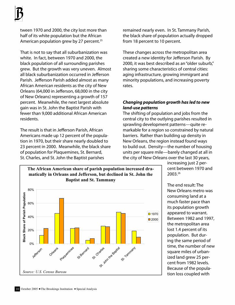
White flight has contributed to suburban growthIn 1970, the city of New Orleans was only 45 percent black. By 1980 the city had become a “majority minority” municipality, and by 2000 the African Ameri-can share of the population had reached 67 percent. Driving these changes, at least in part, was “white flight.” As large num-bers of middle-class white resi-dents left the city, low-income Af-rican American residents (though not all) tended to remain. Be-
October 2005 The Brookings Institution Special Analysis�0
tween 1970 and 2000, the city lost more than half of its white population but the African American population grew by 27 percent.25
That is not to say that all suburbanization was white. In fact, between 1970 and 2000, the black population of all surrounding parishes grew. But the growth was very uneven. Almost all black suburbanization occurred in Jefferson Parish. Jefferson Parish added almost as many African American residents as the city of New Orleans (64,000 in Jefferson, 68,000 in the city of New Orleans) representing a growth of 157 percent. Meanwhile, the next largest absolute gain was in St. John the Baptist Parish with fewer than 9,000 additional African American residents.
The result is that in Jefferson Parish, African Americans made up 12 percent of the popula-tion in 1970, but their share nearly doubled to 23 percent in 2000. Meanwhile, the black share of population for Plaquemines, St. Bernard, St. Charles, and St. John the Baptist parishes
remained nearly even. In St. Tammany Parish, the black share of population actually dropped from 18 percent to 10 percent.
These changes across the metropolitan area created a new identity for Jefferson Parish. By 2000, it was best described as an “older suburb,” sharing some characteristics of central cities: aging infrastructure, growing immigrant and minority populations, and increasing poverty rates.
Changing population growth has led to new land-use patternsThe shifting of population and jobs from the central city to the outlying parishes resulted in sprawling development patterns—quite re-markable for a region so constrained by natural barriers. Rather than building up density in New Orleans, the region instead found ways to build out. Density—the number of housing units per square mile—barely changed at all in the city of New Orleans over the last 30 years,
The African American share of parish population increased dra-matically in Orleans and Jefferson, but declined in St. John the
Baptist and St. Tammany
0%
20%
40%
60%
80%
Jeffe
rson
Orlean
s
Plaque
mines
St.Bern
ard
St. Charl
es
St. Joh
n the
Bap
tist
St. Tam
many
Bla
ck S
hare
of P
aris
h Po
pula
tion
1970
2000
Source: U.S. Census Bureau
increasing just 2 per-cent between 1970 and 2003.26
The end result: The New Orleans metro was consuming land at a much faster pace than its population growth appeared to warrant. Between 1982 and 1997, the metropolitan area lost 1.4 percent of its population. But dur-ing the same period of time, the number of new square miles of urban-ized land grew 25 per-cent from 1982 levels. Because of the popula-tion loss coupled with
��October 2005 The Brookings Institution Special Analysis
the large gain in land consumption, the region actually “de-densified”—its density (population per acre) dropped 21.1 percent (a slightly larger drop in density than the nation, which dropped 20.5 percent).27
Note, too, that much of the land that the region consumed in the post-war years was former wetlands. Engineering allowed the reclama-tion and development of this previously unde-velopable land, but it remained vulnerable to flooding. Ultimately, a much vaster swath of the region’s low-lying flood plain had been convert-ed to subdivisions and other uses when Katrina hit than had been in 1950.
The region’s pre-storm economy was sluggish and provided limited opportu-nity for less-educated workers
Between 1970 and 2000, the New Orleans economy also underwent a change in structure. During that period, the metro suffered a net loss of 13,500 manufacturing jobs, a decline of 23 percent (compared to the nation’s decline of 3 percent). Meanwhile, the service sector grew by 136 percent, the retail sector grew by 76 per-cent, and the finance, insurance, and real estate sector grew by 69 percent. The results of these changes were dramatic. In 1970, manufactur-ing and transportation accounted for 12 and 10 percent, respectively, of the metro’s employ-ment. By 2000, both industries’ shares had dropped to 6 percent. Conversely, the service and retail sectors together expanded from 38 percent of employment in 1970 to 52 percent of employment in 2000.
This had serious repercussions for New Orleans residents. As the region’s economy grew more dependent on the service sector, fewer good-paying jobs were open to individuals without a college degree. For example, in 1970, the
average annual pay for manufacturing jobs was 65 percent higher than the average annual pay for service sector jobs. This ratio was almost the same in 2000, when the average annual pay for manufacturing jobs was 62 percent higher than the average annual pay for service sector jobs. But manufacturing’s share of the metro’s employment was twice as large in 1970 than in 2000.
Overall, the economic shift meant there were fewer good job opportunities available to work-ing class people in recent years.
At the time of the storm, most workers were employed in sectors that paid less than the national averageLooking more closely, the five largest non-farm sectors (excluding government) in the 2003 New Orleans economy were retail, accommo-dation and food service, health care, profes-sional and technical services, and other services (including repair and maintenance, personal services, and laundry). Of these five sectors, however, four of them paid below the $43,061 national average for non-farm earnings, and accommodations jobs fetched no more than $19,131 in average annual pay. In fact, half of the metro’s jobs were in industry sectors that had average annual pay of less than the nation-al average.
The region had several industry strengths, but many of these “export industries” were declin-ing in the post-2000 periodThe shift in the economy since 1970 is not to say that the region was without certain strengths. Before Katrina hit, the region specialized in several industries. Tourism, oil and gas extrac-tion, oil refining, chemical manufacturing, the port and related transportation industries, waste treatment, ship and boat building, com-mercial banking, higher education, corporate
October 2005 The Brookings Institution Special Analysis�2
headquarters, and insurance were the metro’s “export” sectors, the drivers of its economy. All these sectors composed a substantially higher share of employment in the city and/or the met-ropolitan area than in the nation as a whole.
Tourism, higher education and, to a lesser extent, commercial banking were especially important in the city. Several industries within these sectors had a much larger share of employment in the city of New Orleans than the nation as a whole. City employment in hotels and motels, for example, repre-sented nearly five times larger a share of local jobs than it did for the nation as a whole in 2000. Likewise, New Orleanians were about 4.5 times as likely to work for colleges and universities as their counterparts nationwide, while nearly twice as many of them worked in commercial banking as did elsewhere.
The New Orleans economy had relatively high concentrations of jobs in a number of other industries. In particular, navigational services accounted for 22.7 times as large a share of metropolitan area employment as of nationwide employment, oil refining 11.6 times as large a share, ship and boat building 13.6 times as large a share, and oil and gas extraction 6.9 times as large a share.28
These industries are also important to the region because with the exception of tour-ism, they pay more than the city and metro-politan averages. For example, the average annual pay of jobs in oil and gas extraction ($104,192), oil refining ($83,041), basic chemi-cal manufacturing ($79,033), insurance claims adjusting ($50,610), and navigational services to shipping ($46,498) exceeded the $34,403 average annual pay of all jobs in the metro-politan area. For jobs located within the city, the average annual pay of jobs in manage-ment of companies and enterprises ($63,232) and colleges and universities ($43,659) in the
■
■
■
city exceeded the $36,735 average annual pay of all jobs in the city.29
Unfortunately, however, a number of core sec-tors of the New Orleans economy shed jobs in the post-2000 period.
Employment in hotels and performing arts companies declined between 2001 and 2004 in both the city and the metropolitan re-gion.30
Several of the high-wage industries that drove the region’s prosperity pre-Katrina had lost jobs in the post-2000 years. Employment in oil and gas extraction, chemical manufac-turing, and the port and related transporta-tion industries also declined in the region.31
Likewise, well-paying high technology indus-tries played only a small role in the region’s pre-Katrina economy. The New Orleans metro-politan area ranks 38th among the 50 largest U.S. metropolitan areas on the Progressive Policy Institute’s Metropolitan New Economy Index, an index that measures the extent to which regional economies are economically dynamic centers of high technology, new industries, and innovation.32
The result: The New Orleans region’s shift to-ward lower-wage service sectors and recent inability to produce jobs in higher-value indus-tries have each limited the quality of the oppor-tunities available to New Orleans-area workers, both well-educated and less educated.
■
■
��October 2005 The Brookings Institution Special Analysis
III. What Happened: The Impact of Hurricane Katrina on New Orleans
What was happening to greater New Orleans before Hurricane Katrina greatly worsened what happened afterward.
In this regard, Katrina’s impacts were not just massive, but uneven. Broad as it was, the de-struction was not uniform.
Black people and poor people bore the brunt of the devastation because—for the most part—they lived most often in the lower-lying, more flood-prone sections of the city, such as Mid-City or the Lower Ninth Ward. Or as the Louisi-ana State University geographer Craig Colten observes: “With greater means and power, the white population occupied the better-drained sections of the city, while blacks typically inhab-ited the swampy `rear’ districts.”33
Likewise, residents of Jefferson Parish and New Orleans East got hit because post-war decen-tralization of the metropolis had carried devel-opment into former wetlands along Lake Pon-tchartrain that have long suffered from subsid-ence and flooding.
And because of the region’s generally low in-come levels, large numbers of the metropolitan area’s population lacked a car or other means to escape the flood.
To that extent, hydrology and topography have long intersected with race, class, and sociology in the region and did again in early September 2005. The result was the particular devastation that ensued after Katrina hit.
Katrina’s impact in the Gulf Coast and New Orleans region was deep and wide
On the one hand, the sheer size and power of
a storm that made its landfall as a Category 4 event, with winds howling at up to 145 miles an hour, guaranteed that its destruction would be sweepingly far-flung—the worst wreaked by an American natural disaster since a hurricane wiped out Galveston, Texas in 1900, killing 6,000 to 12,000 people.
The facts, in this regard, are awe-inspiring.
Across the Gulf region, Katrina’s human and physical impacts were massive and wide-rang-ing
Some 90,000 square miles of the Gulf Coast region were blanketed by federal disaster declarations—an area roughly the size of the United Kingdom.34
In the weeks following the storm, FEMA distributed aid to over 700,000 households, translating to over 1.5 million people directly affected by the storm.35
As to economic costs, estimates have ranged widely, from $100 billion to $200 billion, with several respected risk assessment companies placing the hurricane’s impact in the range of $120 billion.36
Meanwhile, the death toll stands around 1,200 people in the multi-state affected area, with about 1,000 of the dead having resided in Louisiana.37
Metropolitan New Orleans, for its part, bore the brunt of the storm, which affected wide swaths of its land mass
Residing in the area’s flood zone were some 583,000 people—44.3 percent of the metro population. All told, more than 1.1 million people—86 percent of the metro popula-
■
■
■
■
■
October 2005 The Brookings Institution Special Analysis��
tion—lived in areas that were in some way affected, either through full flooding or other forms of damage.38
Also operating in the flood zone were over 12,000 business establishments (41 percent of the metro area’s total). These establish-ments employed some 200,000 New Orlea-nians in 2003, paid out $6 billion in payroll, and included more than 11,000 small busi-nesses.39
Nearly 228,000 occupied housing units, reflecting more than 45 percent of the met-ropolitan total, were also flooded. This total included 120,000 owner-occupied units (39 percent of the metro total) and 108,000 units occupied by renters (56 percent of the metro total).40
On more human terms, more than 70,000 el-derly people and 124,126 children—57,300 of them residing in single-parent families—lived in the flood zone.41
Likewise, more than 200,000 people across the metropolitan area lacked access to a car—a crucial problem when the time to evacuate came.42
Across the metro the death toll approached 1,000.43
Katrina in this sense was a sweepingly regional event that affected almost everyone across a huge area.
At the same time, striking disparities pre-vailed in how the storm impacted differ-ent communities and families in the New Orleans area
In this respect, the region’s local and neighbor-
■
■
■
■
■
hood-scale development patterns in the de-cades prior to Katrina meant that the disaster played out in starkly uneven ways across the region.
In physical terms, the ways New Orleans’ growth trends have played across its peculiar topography ensured that post-Katrina flood-ing struck different parishes and areas of parishes in different waysOrleans and Jefferson parishes. At the largest scale, the relative concentration of the region’s development in Jefferson and Orleans parish-es—one 65 percent white and one 67 percent black—meant that they absorbed by far the heaviest flooding in the region.44
This reflected the city of New Orleans’ historical development in a “shallow bowl” between the natural levee along the Mississippi River and the Gentilly/Metairie Ridge, and the subsequent urbanization of the low-lying (mostly reclaimed) strip of former swampland along Lake Pon-tchartrain.
As a result, the aggregate impacts were quite focused on the two most populous parishes, Jefferson and Orleans, even though the much less densely populated St. Bernard Parish ab-sorbed a heavier proportional blow.
Together, Jefferson and Orleans parishes accounted for nearly 89 percent (or nearly 520,000 people) of the metro’s affected popu-lation.
Likewise, the two core parishes contained 90 percent of the occupied housing units within the metro flood zone (204,000 of them) and 88 percent of the elderly residents there (63,000 people).
By contrast, St. Bernard Parish accounted for less than 10 percent of the region’s flooded
■
■
■
�5October 2005 The Brookings Institution Special Analysis
Flooded areas of the metropolitan region tended to be poorer, have more renters, and be predom-inately non-white
AreaTotal
Households
Average Household
Income
Percent Owner-
Occupied Housing
Units
Percent Renter-
Occupied Housing
Units
Percent Non-White Population
Poverty Rate
Estimated Population
with No Access to a
Car
New Orleans Metro �98,58� $�9,��� ��.5% �8.5% �5.2% �8.�% 20�,��� Dry Areas of Metro 2�0,908 $5�,�08 �8.9% ��.�% �5.�% �5.�% ��,505
Flooded Areas ofMetro 227,679 $44,479 52.7% 47.3% 58.0% 22.1% 123,671
Dry Areas of Orleans Parish 5�,5�9 $55,��� ��.�% 5�.�% 55.0% 2�.8% 28,0�9
Flooded Areas of Orleans Parish 133,732 $38,263 46.4% 53.6% 80.3% 29.5% 105,152
Dry Areas of Jefferson Parish �0�,�2� $��,�98 �8.�% ��.�% �9.�% �5.�% �0,9��
Flooded Areas of Jefferson Parish 70,107 $56,297 57.0% 43.0% 26.2% 10.1% 11,924
Dry Areas of St. Bernard Parish �,8�2 $�2,9�� �8.�% 2�.9% �8.�% ��.9% �,225
Flooded Areas of St. Bernard Parish 21,281 $44,867 74.1% 25.9% 15.2% 13.0% 5,725
Dry Areas of Plaquemines Parish �,��2 $�8,58� ��.5% 2�.5% 2�.9% ��.8% �,�92
Flooded Areas of Plaquemines Parish 2,559 $42,298 84.8% 15.2% 39.5% 21.0% 869
St. Charles Parish (NoMajor Flooding) ��,�22 $55,2�� 8�.�% �8.�% 29.5% ��.�% �,0�� St. John the Baptist Parish (No Major Flooding) ��,28� $��,0�5 8�.0% �9.0% �9.0% ��.�% �,080 St. Tammany (No Major Flooding) �9,25� $��,590 80.5% �9.5% ��.�% 9.�% 8,�5�
population, although some 84 percent of its residents lived in the flood zone.
Orleans Parish versus Jefferson Parish. A closer look at the two parishes, meanwhile, reveals important differences in how the hurricane af-fected the two areas:
In terms of the scale of the impact, over twice ■
as many New Orleanians (352,849) resided in the flood zone as Jefferson Parish residents (165,866). Likewise, nearly twice as many housing units (133,660) lay in New Orleans’ flooded areas as in Jefferson Parish’s (70,106).
At the same time, the specifics of the flood perimeter and Jefferson Parish’s identity as a whiter “older suburb” ensured that flooding
■
October 2005 The Brookings Institution Special Analysis��
that disproportionately affected New Orleans’ minority, poor, and renter populations hit Jef-ferson Parish’s whites, middle-class citizens, and homeowners hardest.
In New Orleans, minority residents and renters made up 74 percent and 54 percent of the flood-zone population, respectively. In these areas the average annual house-hold income was just $38,300.
In Jefferson Parish, by contrast, white residents and homeowners made up 74 percent and 57 percent of the flooded pop-ulation. The average household income in these areas was $56,300—significantly higher than the $47,700 income in areas that did not flood.
By neighborhood and topography. Also influenc-ing the shape of the flood zone was the par-ishes’ finer-grained topography. Most notably, development patterns across the modest rises and troughs, ridges and marshes of the New Orleans basin heavily influenced which neigh-borhoods were affected.
Within Orleans Parish, the topography was stark:
The location of the city’s oldest, highest-value sections along the crescent-shaped, higher-elevation “natural levee” of the Mississippi ensured that areas like the French Quarter, the Central Business District, the Garden District, Uptown, and Audubon escaped the worst flooding.
By contrast, urbanization of the lowest-lying areas of the “shallow bowl” just lakeside of the natural levee as well of low-lying areas arcing east into the Ninth Ward ensured that neighborhoods like Leonidas, Mid-City, Gert Town, B.W. Cooper, the Seventh Ward, and the Lower Ninth Ward were all inundated.
■
■
Also flooded severely was the wide strip of marshland sweeping north of the city to Lake Pontchartrain and east along it on either side of I-10. Along this strip middle- and higher-income subdivisions like Lakeview, Gentilly, Pontchartrain Park, and Little Woods on out across New Orleans East were seriously af-fected.
In Jefferson Parish, the variations were simpler and starker.
What didn’t get flooded were, for the most part, higher-elevation Mississippi River-front-ing suburban towns like Jefferson (adjacent to New Orleans), middle-class Harahan, and higher-end River Ridge upstream to the West.
What did get flooded, by contrast, was Jef-ferson Parish’s large swath of lakefront low ground, sweeping along Lake Pontchartrain and on either side of I-10. Along this strip, ar-eas like the Lake View Mall area near the city of New Orleans, vast Metairie, and Kenner to the west were all heavily flooded.
In demographic terms, the intricate social topography of New Orleans’ development pat-terns ensured that sharp variations of impact were felt across racial, class, and household linesIn this connection, sociology intersected quite exactly with geography and topography across the metropolitan area, and ensured that minor-ity residents, poor people, and renters were all more likely to reside in the flood zone than white residents, better-off people, or those who owned their homes. The divides were sharp:
Race. The region’s racial geography ensured that those areas hit hardest by the flood were disproportionately non-white.
Overall, blacks and other minority residents
■
■
■
■
��October 2005 The Brookings Institution Special Analysis
made up 58 percent of those whose neigh-borhoods were flooded, though they encom-passed just 45 percent of the metropolitan population.
By contrast, whites made up just 42 percent of those who lived in neighborhoods that flooded. In New Orleans the cleavage was even starker. The flooded areas there were 80 percent non-white.
Class. Similarly, the region’s income and poverty disparities across races guaranteed that those who resided in the flood zone across the metro-politan area were much poorer than those who lived on higher ground, and lived far more often in areas of extreme poverty:
The average household income in areas that were flooded hovered at just $44,500 in 2000. By comparison households living outside the
■
■
flood zone earned average incomes of about $53,000.45
In Orleans Parish the average income reached only $38,263 in the flooded areas, compared to $55,300 in the areas not flooded.
The fate of the region’s neighborhoods of concentrated poverty was even more tell-ing. Thirty eight of the metropolitan area’s 49 extreme poverty census tracts were flooded. Moreover, all of the extreme poverty tracts that were flooded were located within the city of New Orleans. Altogether, more than 41,000 poor people—virtually all of them black—lived in extreme poverty census tracts.
Household profile. Finally, the metropolitan area’s sharp geographical differences in house-hold type and well-being ordained that those
■
■
Orleans
JeffersonSt. Bernard
Plaquemines
St. Charles
Source: USGS, Census, FEMAElevation (USGS 2001)
below sea level-0.5 ft to 0.5 ft (sea level)above sea level
Katrina Flood ExtentParish boundary
Lake Pontchartrain
The region’s peculiar low-lying topography determined which parts of the region flooded and which did not
October 2005 The Brookings Institution Special Analysis�8
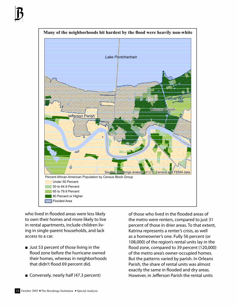
who lived in flooded areas were less likely to own their homes and more likely to live in rental apartments, include children liv-ing in single-parent households, and lack access to a car.
Just 53 percent of those living in the flood zone before the hurricane owned their homes, whereas in neighborhoods that didn’t flood 69 percent did.
Conversely, nearly half (47.3 percent)
■
■
of those who lived in the flooded areas of the metro were renters, compared to just 31 percent of those in drier areas. To that extent, Katrina represents a renter’s crisis, as well as a homeowner’s one. Fully 56 percent (or 108,000) of the region’s rental units lay in the flood zone, compared to 39 percent (120,000) of the metro area’s owner-occupied homes. But the patterns varied by parish. In Orleans Parish, the share of rental units was almost exactly the same in flooded and dry areas. However, in Jefferson Parish the rental units
The New Orleans Metro Area
Lake Pontchartrain
Source: Brookings analysis of U.S. Census and FEMA data
Jefferson Parish
Orleans Parish
Percent African American Population by Census Block GroupUnder 50 Percent50 to 64.9 Percent65 to 79.9 Percent80 Percent or HigherFlooded Area
Many of the neighborhoods hit hardest by the flood were heavily non-white
�9October 2005 The Brookings Institution Special Analysis
were far more prevalent in the submerged ar-eas. Forty three percent of the housing units in Jefferson Parish’s flood zone were rental units, but only 32 percent were in areas that did not flood.
Likewise, 46 percent of all the children who were living in flooded areas when Katrina hit had only one parent, compared to 31 percent in dry areas. All told, 57,300 children whose neighborhoods were flooded had only one parent.
■
Finally, significantly more people in flooded areas lacked access to a car—a fact that became critical during the evacuation period. Specifically, about one in five people in parts of the metro that would flood had no access to a car, versus one in ten elsewhere. Not sur-prisingly, this problem also varied significant-ly by parish. While only 7.2 percent of the households in Jefferson Parish’s flooded areas lacked access to a car, 30 percent of Orleans households did. In Orleans Parish that share meant that more than 105,000 residents lacked access to a car when the time came to
■
The New Orleans Metro Area
New Orleans East
B.W.Cooper Algiers
Uptown
SeventhWard
PontchartrainPark
Mid-City
LowerNinthWard
LakeviewGentilly
GardenDistrict
FrenchQuarter
Audubon
St.BernardParish
JeffersonParish
Lake Pontchartrain
Source: Brookings analysis of U.S. Census and FEMA data
Concentrated Poverty by Census TractCensus Tracts with Concentrated Poverty (Greater than 40 Percent)Census Tract BoundaryFlooded Area
Most of the high-poverty tracts in the city of New Orleans were flooded during the aftermath of the hurricane
October 2005 The Brookings Institution Special Analysis20
evacuate.
In sum, how Hurricane Katrina affected particu-lar New Orleanians and their neighborhoods depended intimately on where they lived, and that owed heavily to the metropolitan area’s troubling social, economic, and land-use trends in recent decades.
The region’s sharp racial and income dispari-ties across geography and topography placed blacks and poor people disproportionately in the flood zone. The region’s unbalanced patterns of sprawl and concentrated poverty reinforced that pattern and placed thousands of suburbanites in harm’s way along the lakefront corridor. And beyond that, the region’s general lack of prosperity ensured that hundreds of thousands of New Orleanians lacked the where-withal to flee the storm by car.
To that extent, the disastrous impact of Hur-ricane Katrina in 2005 was not inevitable. It represented instead a malign intersection of weather and water with a man-made social and racial topography that had been created over decades.
IV. Why It Happened: New Orleans, Hurricane Katrina, and Federal Policy
What happened to greater New Orleans when Katrina struck had a lot to do with what was happening there before the disaster—that is plain. But there remains another link in the chain: What was happening before Katrina owes at least in part to government policies, including federal ones.
Granted, how the disaster played out also reflected the accidents of history, as well as the
influence of state and local policy decisions.
Most obviously, the city founders’ placement of their “inevitable city” in an “impossible” water-logged setting, as Peirce Lewis describes it, determined much of what transpired. Likewise, the legacy of Jim Crow-era municipal ordinanc-es and later deed covenants also mattered, as those codes helped to systematically exclude blacks from better-drained white communi-ties, determining much of the area’s pre-Katrina social geography.46
Yet for all that, the federal hand in New Orleans’ development has been extraordinary, signifi-cantly influencing (in partnership with state and local decision-making) how the metropolitan area grew and Katrina’s impact.
Most notably, the federal influence on regional housing policy—in conjunction with state and local choices—clearly exacerbated racial and ethnic disparities in New Orleans. Likewise, the federal roles in building highways and provid-ing flood protection—again in partnership with state and local transportation departments, land-use regimes, and levee boards—promoted unsustainable growth patterns that accentu-ated divisions and placed more New Orleanians in harm’s way.
Which is not to say—to emphasize it once again—that the federal influence was unilateral and decisive by itself. State and local govern-ments, which had the power to decide exactly where New Orleans housing, road, and flood control projects were located, were equally cul-pable. However, without federal funding, over-sight, and planning, these projects would never have taken place. So to that extent, the federal government that enabled and supported the decisions of state and local authorities does in fact share responsibility for the results.
2�October 2005 The Brookings Institution Special Analysis
Federal housing policies financed and maintained enclaves of poverty and ex-acerbated racial disparities in the city of New Orleans
The first major way federal policy exacerbated how the storm affected New Orleans is through its low-income housing policies. Over 60 years, these policies catered to the very poor by concentrating many of them in special enclaves that in New Orleans lay almost exclusively in the lower-lying, more flood-vulnerable sections of the city.
This outcome is tragic and ironic, given New Orleans’ initial mingling of races and classes.47 But at any rate, this history of relative residential integration did not last, and the federal govern-ment played a significant role in replacing it—in two ways.
Public housing projects increased the city’s concentrations of poverty Most glaringly, the nationwide federal effort to supply what was intended to be high-quality, inexpensive public housing bears significant re-sponsibility for concentrating poverty in dense clusters in low-lying neighborhoods.
As it happens, the Housing Authority of New Orleans—created by state law in 1937—was the first such agency in the United States to receive federal funds for slum clearance and publicly subsidized housing.48 What resulted, as the money flowed for 30 years, was the creation in collaboration with the housing authority of 10 big public housing projects—all now almost en-tirely black, and all sited in what would become some of Katrina’s most dire flood zones.
The first six projects opened in the early 1940s, and included four developments for blacks (Magnolia, Calliope, Lafitte, and St. Bernard) and
two for whites (St. Thomas and Iberville).49 Legal scholar Martha Mahoney notes explicitly that the all-black Laffite replaced a historically mixed neighborhood of whites, blacks, and Creoles, and that several others increased racial concen-tration in the city.50
Similarly, when the 1949 Housing Act funded 5,000 new dwelling units for New Orleans, the local housing authority located the new de-velopments adjacent to existing ones, nearly doubling the size of several projects and so enlarging the federal enclaves. The Magnolia extension, for example, displaced the homes of black doctors and ministers near the Flint-Go-odridge Hospital as well as the remnants of an old slum area.51
Additional isolation followed the construction of three more new projects between 1956 and 1964. The huge Desire project (where Desire Street crosses Abundance), for instance, placed 262 buildings containing 1,860 apartments on a geographically isolated tract, cut off from the rest of New Orleans by two canals and two sets of railroad tracks. Comments Mahoney: “Due to its size and isolation, Desire deserves the label ‘federal ghetto’ more so than any of the other New Orleans projects.”52 Similarly isolated was the Fischer development, which lay on a point of land across the Mississippi River from the rest of New Orleans. Fischer imposed a large, concentrated project on a small, less-populated black community, according to Mahoney.53
The isolation of black citizens only deepened as whites began to leave town for the suburbs in the years following World War II.54 With whites leaving, the black presence in many formerly white or mixed neighborhoods increased, the gaps between black areas began to fill in, and, as Mahoney writes, “the outlines of large con-centrations of black residents…began to take shape.” By 1985, Mayor Ernest Morial estimated that city housing projects population contained
October 2005 The Brookings Institution Special Analysis22
no less than 50,000 New Orleanians—or 9 per-cent of the city population.55
In this way, step by step, federal housing re-lief really did have the perverse outcome of increasing racial and geographical divisions in the region by creating large, highly segregated enclaves of poverty in the city of New Orleans
where they had not existed before.
Nor has the heavy recent use of the U.S. Depart-ment of Housing and Urban Development’s HOPE VI program to dismantle old housing blocks, build new communities, and provide thousands of Section 8 housing vouchers to low-income residents completely broken up the
The New Orleans Metro Area
Mid-City
LowerNinthWard
Audubon
NewOrleans East
St.BernardParish
Jefferson Parish
Lake Pontchartrain
Source: Brookings analysis of U.S. Census data, the Greater NewOrleans Community Data Center, and the Housing Authority of New Orleans
Poverty Rate by Census TractUnder 10 Percent10 Percent to 19.9 Percent20 Percent to 29.9 Percent30 Percent to 39.9 Percent40 Percent or HigherNeighborhood Boundaries
Public Housing32 to 400 Units401 to 700 Units701 to 1,000 Units1,001 to 1,300 Units1,301 to 1,462 Units
St. BernardArea
B.W.Cooper
Central City
Desire
Iberville
Fischer Project
Lakeview
Florida
Public housing was primarily sited in very poor neighborhoods
2�October 2005 The Brookings Institution Special Analysis
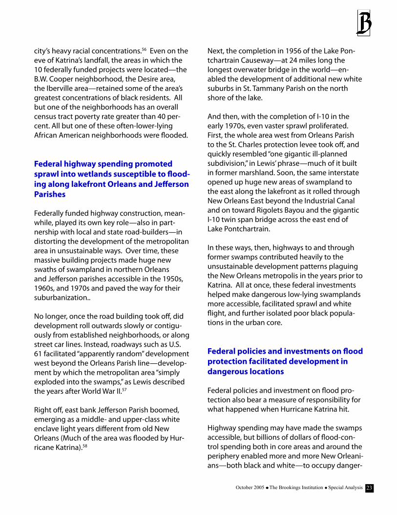
city’s heavy racial concentrations.56 Even on the eve of Katrina’s landfall, the areas in which the 10 federally funded projects were located—the B.W. Cooper neighborhood, the Desire area, the Iberville area—retained some of the area’s greatest concentrations of black residents. All but one of the neighborhoods has an overall census tract poverty rate greater than 40 per-cent. All but one of these often-lower-lying African American neighborhoods were flooded. Federal highway spending promoted sprawl into wetlands susceptible to flood-ing along lakefront Orleans and Jefferson Parishes
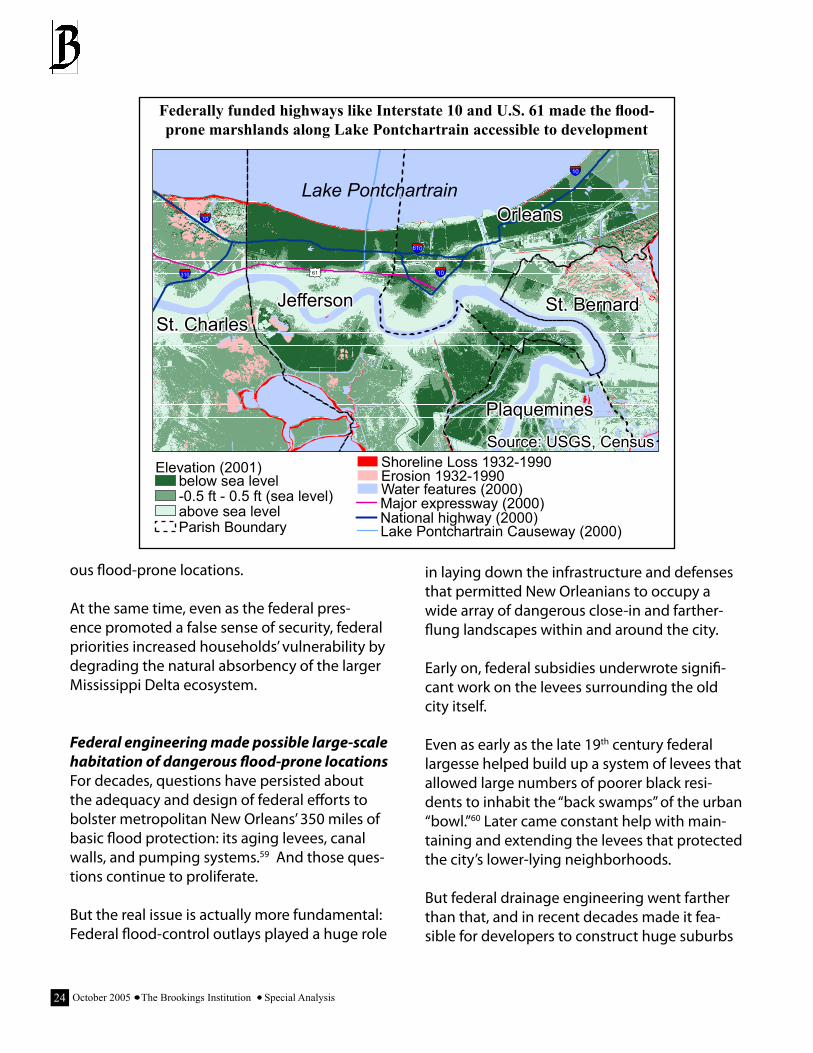
Federally funded highway construction, mean-while, played its own key role—also in part-nership with local and state road-builders—in distorting the development of the metropolitan area in unsustainable ways. Over time, these massive building projects made huge new swaths of swampland in northern Orleans and Jefferson parishes accessible in the 1950s, 1960s, and 1970s and paved the way for their suburbanization..
No longer, once the road building took off, did development roll outwards slowly or contigu-ously from established neighborhoods, or along street car lines. Instead, roadways such as U.S. 61 facilitated “apparently random” development west beyond the Orleans Parish line—develop-ment by which the metropolitan area “simply exploded into the swamps,” as Lewis described the years after World War II.57
Right off, east bank Jefferson Parish boomed, emerging as a middle- and upper-class white enclave light years different from old New Orleans (Much of the area was flooded by Hur-ricane Katrina).58
Next, the completion in 1956 of the Lake Pon-tchartrain Causeway—at 24 miles long the longest overwater bridge in the world—en-abled the development of additional new white suburbs in St. Tammany Parish on the north shore of the lake.
And then, with the completion of I-10 in the early 1970s, even vaster sprawl proliferated. First, the whole area west from Orleans Parish to the St. Charles protection levee took off, and quickly resembled “one gigantic ill-planned subdivision,” in Lewis’ phrase—much of it built in former marshland. Soon, the same interstate opened up huge new areas of swampland to the east along the lakefront as it rolled through New Orleans East beyond the Industrial Canal and on toward Rigolets Bayou and the gigantic I-10 twin span bridge across the east end of Lake Pontchartrain.
In these ways, then, highways to and through former swamps contributed heavily to the unsustainable development patterns plaguing the New Orleans metropolis in the years prior to Katrina. All at once, these federal investments helped make dangerous low-lying swamplands more accessible, facilitated sprawl and white flight, and further isolated poor black popula-tions in the urban core.
Federal policies and investments on flood protection facilitated development in dangerous locations
Federal policies and investment on flood pro-tection also bear a measure of responsibility for what happened when Hurricane Katrina hit.
Highway spending may have made the swamps accessible, but billions of dollars of flood-con-trol spending both in core areas and around the periphery enabled more and more New Orleani-ans—both black and white—to occupy danger-
October 2005 The Brookings Institution Special Analysis2�
ous flood-prone locations.
At the same time, even as the federal pres-ence promoted a false sense of security, federal priorities increased households’ vulnerability by degrading the natural absorbency of the larger Mississippi Delta ecosystem.
Federal engineering made possible large-scale habitation of dangerous flood-prone locations For decades, questions have persisted about the adequacy and design of federal efforts to bolster metropolitan New Orleans’ 350 miles of basic flood protection: its aging levees, canal walls, and pumping systems.59 And those ques-tions continue to proliferate.
But the real issue is actually more fundamental: Federal flood-control outlays played a huge role
in laying down the infrastructure and defenses that permitted New Orleanians to occupy a wide array of dangerous close-in and farther-flung landscapes within and around the city.
Early on, federal subsidies underwrote signifi-cant work on the levees surrounding the old city itself.
Even as early as the late 19th century federal largesse helped build up a system of levees that allowed large numbers of poorer black resi-dents to inhabit the “back swamps” of the urban “bowl.”60 Later came constant help with main-taining and extending the levees that protected the city’s lower-lying neighborhoods.
But federal drainage engineering went farther than that, and in recent decades made it fea-sible for developers to construct huge suburbs
Federally funded highways like Interstate 10 and U.S. 61 made the flood-prone marshlands along Lake Pontchartrain accessible to development
61310
10
10
10
Jefferson
Orleans
St. CharlesSt. Bernard
Plaquemines
610
Source: USGS, CensusElevation (2001)
Water features (2000)below sea level-0.5 ft - 0.5 ft (sea level)above sea level
Shoreline Loss 1932-1990Erosion 1932-1990
Major expressway (2000)National highway (2000)Parish Boundary Lake Pontchartrain Causeway (2000)
Lake Pontchartrain
25October 2005 The Brookings Institution Special Analysis
in the newly road-accessible marshlands to the north, west, and east of the old city.61
Prior to World War II, New Orleans’ growth had been inhibited not just by Lake Pontchartrain to the north but by vast wetlands along its shores to the west, north, and east.62 However, by the 1950s big new federally-supported seawall and drainage projects along the lakefront “de-wa-tered marshlands for tract housing” all along the emerging I-10 corridor east from the city and west into Jefferson Parish.63 Soon, populous new suburbs sprang up all across former wet-lands along the lake and to the east—all areas that would flood in 2005. Similarly, the number of housing units in St Bernard Parish more than doubled in the 40 years after the 1965 comple-tion of the well-leveed Mississippi River Gulf Outlet, a 66-mile shipping canal now suspected of funneling huge storm surges into the parish and devastating it.
To that extent, federal engineering quite liter-ally made the metropolitan area safe (at least superficially) for a variant of sprawl that placed thousands of suburbanites in the way of dan-gerous storm events and floods.
Federal floodplain management created a false sense of security and failed to discourage flood-plain developmentFederal culpability in New Orleans’ vulnerability goes beyond building structures that directly facilitated floodplain development, however. More generally, federal floodplain policy sent mixed signals and failed to discourage develop-ment in flood-prone areas.
In the broadest sense, decades of federal work on structural flood control projects unwittingly conveyed a false sense of security to the region. Constant engineering suggested growing safety and—in the absence of other cautions—com-municated a tacit go-ahead to development.
But the federal government abdicated its leadership responsibility in more specific ways. Most glaringly, the traditional federal deference to state and local land-use planning has meant that federal spending on levees and other pro-tections has been unaccompanied by sensible restrictions on subsequent construction.64 That, in turn, has meant that federal flood control has inadvertently facilitated inappropriate develop-ment in flood-prone locations.
At the same time, the availability of subsidized federal flood insurance for new development in flood plains, and its coverage of repetitive losses, also represents a failure of Washington to take the lead in discouraging communities from building in harm’s way.65 Even though the most recent revision of the program made some attempt to deal with the problem, the bottom line is that in the New Orleans area, as elsewhere, the program’s low premiums and liberal terms may encourage growth and devel-opment in risky areas. In Louisiana, for example, the government is insuring more than 11,000 flood-prone properties that have been paid for damages from previous floods, nearly 5,000 of which collected four or more times, according to FEMA records.66
One result: Orleans and Jefferson parishes ranked first and second nationwide among localities for their numbers of claimants receiv-ing repeat payments for damage claims under the National Flood Insurance Program between 1978 and 1995. Together the parishes account-ed for 20 percent of the nation’s properties with repeat losses during that time.67
The federal bias toward structural solutions undermined the effectiveness of natural buf-fersFinally, federal manipulation of the larger Mis-sissippi Delta and its bias for structural solutions to flood hazards has almost certainly increased
October 2005 The Brookings Institution Special Analysis2�
New Orleanians’ vulnerability by degrading the buffering potential of the larger landscape in which they live.
In this respect, many experts agree the U.S. Army Corps of Engineers’ manhandling of the entire delta ecosystem with flood control proj-ects and channel “improvements” also increased the threats to homeowners and businesses.
Federal river and flood control initiatives have of course sought to reduce the metropolitan area’s exposure to hazards. However, an unwanted side-effect of these projects has been to reduce the natural sponge effect of the local environ-ment, with its myriad swamps and bayous and islets. The result has been a severe erosion of the important role nature itself plays in reduc-ing the force of natural hazards.
Close in, as Colten observes, the draining, levee-ing, and development of Lake Pontchartrain-area wetlands altered what had been a wide marsh and swamp buffer between the city and the lake, placing new residential districts in danger and removing the ability of tracts to the north of the urban core to protect it from waves and storm surges flowing off the lake.68
More broadly, the Corps’ titanic struggles to fix the course of the Mississippi River itself have tended to channel the river’s sediments—which once replenished the Mississippi Delta and kept it above water—past dry land and out into the Gulf of Mexico. At the same time, development has further disrupted the ecosystem and led to widespread wetlands destruction along the coast.
The result has been an even more severe ero-sion of the larger ecosystem’s ability to absorb shocks or deflect them from the built-up area.
Starved of silt, the vast, shock-absorbing buffer zone of the delta’s wetlands and barrier islands
is rapidly disintegrating.69 Islands that once cut down storm surges and waves have shrunk or disappeared. Downstream marshes are sinking into open water. In fact, the Corps estimates that nearly 1 million of the 4 million acres of Louisiana coastal wetland that once absorbed floodwaters have been lost, and that, if unat-tended, another 330,000 acres will be lost over the next half century. Such changes, say scien-tists, have left the New Orleans area exposed, naked to the sea.70 According to Roy Dokka, a geologist at Louisiana State University, flooding will likely grow even worse in the coming de-cades, not just in New Orleans but in the entire Gulf Coast region.71
What does all this mean? What it means is emphatically not that federal housing, highway, and flood protection alone determined Hur-ricane Katrina’s impact. City housing authority policy, state highway programming, and the choices of local levee authorities and zoning panels also exacerbated matters. So too did state and local evacuation and emergency re-sponses. But even so, the facts suggest that key federal development policies—harmful in many metropolitan areas—proved especially baleful across the low-lying basin and one-time marsh-es of New Orleans. That intersection, of flawed policies with a peculiar geography, substantially worsened what happened when Katrina made landfall.
V. AFTER THE STORM: A Federal Re-construction Agenda for New Orleans
Confronting New Orleans is a reconstruction both gargantuan and unique in scale and scope.
How should a low-lying city built in a bowl and sprawling across flood-prone swamps be rebuilt
2�October 2005 The Brookings Institution Special Analysis
not only to last, but flourish?
How should a racially and economically divided region move toward equity and inclusiveness?
And how should what was a drifting low-wage economy before Hurricane Katrina be bolstered so it provides better opportunities for the region’s workers and families?
One thing is clear: Reconstructing New Orleans in the proper way is going to take a sustained, serious, and yes, visionary concentration over years on the part of all levels of government, but most especially Washington.
For Washington owes it to the Gulf region, and especially metropolitan New Orleans, to help undo the influence of decades of flawed federal policies—policies that, while well-intentioned at the time, combined with state and local er-rors to reinforce residential segregation, facili-tate development outward and into low-land marshes, and increase the area’s overall vulner-ability to flooding.
Fortunately, President Bush has acknowledged the government’s “duty to confront” the “deep, persistent poverty” exposed by Hurricane Ka-trina. Beyond that he has also pledged to “do what it takes” to help New Orleans “rise again.”
And so, given the sheer vastness of the task ahead, the reconstruction of New Orleans provides an unprecedented moment for the nation—in partnership with an important region—to actually deliver on the president’s large promises and ensure New Orleans really can “rise again.”
Specifically, the time has come for the federal government to consider—seriously—what a truly integrated, deep-going agenda for urban transformation would look like, and then enact it in one place.
Implicit in such an agenda are three threshold principles: Don’t replicate the mistakes of the past. Build on a great city’s assets. And ensure that reconstruction benefits long-time Orleanians by adhering to an inclusive planning process.
These mean at minimum that the reconstruc-tion must break with past misguided policies; respect the city’s vivid traditions of architecture and racial integration; and guard against the threat that the rebuilding will become a closed-door Gold Rush that spurns community input and decision-making.
Yet these are only principles: In terms of its actions, the nation must aim for three critical outcomes in resurrecting greater New Orleans. It must:
Make the region a paragon of high-quality, sustainable development
Transform neighborhoods of poverty into neighborhoods of choice
Move the economy from the low-road to the high road
In sum, the necessary agenda must be at once basic and bold.
And yet, one more comment is in order: All of this must be pursued with an eye to efficiency and cost-effectiveness, which means that poli-cymakers should turn wherever possible to the nation’s many proven programs for providing housing, providing infrastructure, and boosting the economy. Moreover, many of these pro-grams can easily and affordably be scaled up to the task at hand.
What follows, then, lays out a sensible three-pronged framework for rebuilding a shattered metropolitan area in a way that makes it more sustainable, more inclusive, and more competi-
■
■
■
October 2005 The Brookings Institution Special Analysis28
tive in the global economy than it was before the flood.
Make the region a paragon of high-qual-ity, sustainable development
The first priority in reconstructing New Orleans must be to ensure that what rises there is at once sustainable, distinctive, and high quality.
Tragically, Hurricane Katrina revealed that much about metropolitan New Orleans was not sus-tainable.
Thousands of modest, aging structures built below sea level in the urban center were inun-dated, fulfilling decades of predictions. Fifty years of lightly regulated suburban sprawl into the marshlands, meanwhile, placed thousands of newer structures in harm’s way. And for that matter, grave questions have been raised again about the entire engineering-oriented, seawall and levee-oriented approach to flood protec-tion. Seeking to dominate nature with struc-tural solutions did not work.
And so, those who will shape the reconstruc-tion must ensure that the federal presence helps make New Orleans a paragon of sensible, balanced, and high-quality 21st-century devel-opment. In this vein, Washington should not dictate outcomes but absolutely must insist that the reconstruction process promotes sus-tainability in every dimension. Four watchwords matter most:
Plan where to rebuild—systematically and democraticallyFirst, the federal government must work with state and local government in making the sensitive foundational decision about where reconstruction should and should not occur in greater New Orleans.
Clearly, this will be a tough judgment, given both the unmistakable continuing risks faced by some neighborhoods and the understand-able sensitivities of those reluctant to move away from home ground.
And yet, some middle-ground judgment must be made—soon—and it must be made in a sys-tematic, transparent, and objective way, so that all leaders and residents discuss the choices available and the associated trade-offs.
And so the federal government should take the lead in convening a world-class deliberation of the region’s top federal and other experts to as-sess the situation, and consider where rebuild-ing may and may not make sense, based on the best environmental and engineering research. Once that basic work is done, this process should distill the trade-offs between differ-ent scenarios, and convey it all—in full public view—to policymakers and the local citizenry for deciding the right path. Do this well, with clarity and transparency and objectivity, and metro New Orleans as well as the nation will gain something critical: a solid foundation on which to build.
Use reconstruction money to promote sound land use and high-quality city designA second way the federal government should promote quality, sustainable reconstruction is by tying infrastructure and other dollars to requirements of sensible city planning.
A major federal lapse of the past—in New Orleans and elsewhere—has been the govern-ment’s failure to make sure that its expenditures on roads, infrastructure, and flood protection did not inadvertently facilitate undesirable de-velopments on the ground. Such past laxity has been disastrous across New Orleans’ floodplain.
29October 2005 The Brookings Institution Special Analysis
So this time, the federal government must as-sert a leadership role.
Notwithstanding the traditional primacy of state and local land-use planning, most impor-tantly, federal redevelopment money should come now with sensible strings attached.
President Bush himself has spoken, for example, about the need for better planning and zon-ing laws. Therefore, federal replacement and new infrastructure funds for roads, water/sewer lines, and schools should require those—and not just in Katrina’s immediate flood zones but across the reconstruction area, in accord with sound planning decisions about where build-ing should and should not go on. And why shouldn’t the federal government promote a full suite of contemporary “best practices” for city-building: compact, pedestrian-friendly neighborhood designs; distinctive coastal archi-tecture; mixed-use and transit-oriented devel-opment; density enhancements in “dry” areas and limits in flood-prone areas?
In these ways, the federal government could at once make sure its money isn’t wasted and get beyond mere check-writing to actually rebuild-ing New Orleans better than it was.
Invest in transit to promote reinvention Another boost to reinvention should be a major federal investment in light rail or rapid bus lines. Transportation infrastructure improvements should not be limited to roads and bridges. Bolstered transit service would help reduce the isolation of many low-income neighborhoods and better link neighborhoods to workplaces in a city with low car access. But even beyond that, restored and extended transit lines—arrayed in conjunction with the master-planning pro-cess—could furnish the framework for future transformation. Most important, a strength-ened system could support the emergence of increased density in safer, higher-elevation
areas and along key corridors and nodes. Top-quality future development could then be encouraged around stops and stations.
Restore the DeltaFinally, the federal government should fully em-brace—and fund—massive ecosystem restora-tion across the entire Gulf region but most cru-cially up and down the Mississippi River Delta.
America has now witnessed the limits of struc-tural solutions to New Orleans’ flood-protection problems. So, too, has the nation been learning how wetland and barrier-island deterioration—caused by sprawl and river channelization—fur-ther exposed the city.
Consequently, the federal government should make the Delta into a world watchword for working with nature to deter flooding though landscape restoration.
If more of the marshy lowlands between the city and the Gulf of Mexico were returned to nature, river-borne silt could again accumulate, maintaining or rebuilding natural wetlands and barrier islands. In that fashion, nature herself—if managed properly—could again surround the new New Orleans with a protective, region-scaled buffer between violent storm surges and the city’s engineered defenses.
To that end, then, federal and state agencies should work together to develop a comprehen-sive plan to restore Louisiana’s coastal wetlands and barrier islands, and Congress should au-thorize and fund it. As it happens, such a plan exists. Called Coast 2050, this outline enjoys significant support from both local officials and scientists, but with a price tag of $14 billion over several decades it has not been funded. Now is the time to begin the work.
October 2005 The Brookings Institution Special Analysis�0
Replace neighborhoods of poverty with neighborhoods of choice and connec-tion
The second priority of reconstruction must be to confront what President Bush called the “deep, persistent poverty” exposed by Katrina. Poverty, and its companion con-centrated poverty, simply cannot be toler-ated as the nation rebuilds New Orleans.
But to strike at poverty, to strike at depriva-tion, the federal government will need to rebuild New Orleans’ shattered neighbor-hoods, and do it in a way that knits togeth-er a divided city.
Unfortunately, the president’s main pro-posal on this front—his Urban Homestead Initiative to transfer federally owned land to low-income families—falls short in meeting the scale of the New Orleans’ housing challenge and, worse, may actu-ally recreate the concentrated poverty that predated Katrina.
Happily, though, a better way to respond—based on proven past successes—exists.
With its state, local, and private-sector part-ners, the federal government must move energetically now to remake New Orleans’ dozens of neighborhoods of deprivation and isolation as vibrant new neighborhoods of choice and connection.72
What are neighborhoods of choice and connection?
Neighborhoods of choice are desirable com-munities that families of all income levels seek out for their quality, distinctiveness, sociability, location, and amenities. Such neighborhoods are above all mixed-in-come neighborhoods.
Neighborhoods of connection are neighbor-hoods that link families to opportunity, rather than isolate their residents. These neighbor-hoods offer their residents good schools and timely services. These communities provide to their citizens easy access to nearby or distant job markets, as well as connection to the main-stream life of the region.
Neighborhoods of choice and connection, to that extent, reject the residential segregation and concentrated poverty of pre-Katrina New Orleans, and hold out a vision of a reborn New Orleans region vibrant with mixed-income communities attractive to all classes, schools on track to succeed, measurably better pub-lic transportation, and stronger links to the world of work. In this fashion, neighborhoods of choice and connection are the true basis for solving many of the New Orleans region’s problems, creating, if done right, better schools, functioning real estate markets, and greater business investment.
And so the federal government—with its part-ners—should make the most of reconstruction by helping the region replace its neighbor-hoods of poverty with neighborhoods of choice and connection.
To do this, Washington should embrace the proven successes of an array of available part-ners and recent efforts to transform the nation’s worst public housing and expand the opportu-nities for low-income families beyond high-pov-erty neighborhoods.73
Most importantly, federal leaders should keep in mind the achievements of the HOPE VI pro-gram, which over the past 10 years catalyzed the transformation of many of the nation’s most distressed projects into well-designed, mixed-income neighborhoods. Likewise, they should draw on the success of programs like the Moving to Opportunity (MTO) demonstra-
��October 2005 The Brookings Institution Special Analysis
tion, which helped families in select cities move from distressed public housing to low-poverty suburbs, and others that use tax credits or other funding streams to produce affordable housing, especially in low-poverty areas.
Likewise, Washington should draw on the expertise of the most sophisticated housing fi-nance and development system in the world—America’s broad array of public-and private-sec-tor financial institutions, builders, community development corporations (CDCs), faith-based groups, and intermediaries like the Local Initia-tives Support Corp.(LISC) and the Enterprise Foundation.
Put it all together, and the federal government must play a bold new role now to stimulate and reshape the New Orleans area housing market, both on the demand side to promote social mobility and on the supply side to rebuild neighborhoods in the right way. Five interven-tions will help:
Provide housing vouchers to displaced fami-lies to increase choice and mobilityWide, long-term access to renewable federal housing vouchers ought to be the starting point, and a core element, of the drive to cre-ate neighborhoods of choice and connection in New Orleans.
Housing Choice Vouchers represent one of the most humane, dignified options for providing near-term shelter to the displaced—wher-ever they may be. But housing vouchers are also critical to the longer-term recovery of the region. All in one they have the power to re-animate housing markets and foster the emer-gence of more diverse, healthy mixed-income neighborhoods.
Vouchers, in the first place, will be essential to stimulate local market demand. But beyond
that studies have also shown that families who use vouchers often use them to live in lower-poverty neighborhoods, near better employ-ment and educational opportunities. That means that in helping returnees repopulate their city, vouchers will also help New Orlea-nians move to better, less-segregated, higher-ground neighborhoods as they resettle. And the architects of rebirth should note that hous-ing vouchers can be applied not just to rent but to mortgage payments. That means that vouchers are good for both former renters and homeowners, and can inject a powerful spur to homeownership.
Deploy increased CDBG and HOME funds to speed clean up and land assemblyTo jumpstart the cleanup and renewal process, Congress and the administration should also greatly increase the streams of funding avail-able to the devastated area under the Com-munity Development Block Grant (CDBG) and HOME Investment Partnerships Program, the two main sources of federal support for state and local urban revitalization and affordable-housing initiatives.
CDBG and HOME will be crucial to the creation of neighborhoods of choice and connection, in part because they are flexible. CDBG money is specifically available for such critical needs in rebuilding New Orleans’ neighborhoods as debris clearance; demolition, clearance, and reconstruction of damaged property; and emer-gency reconstruction of essential utilities. For its part, HOME remains the largest federal block grant to state and local governments designed exclusively to create affordable housing for low-income households—a huge need in coming years in New Orleans. For each, local discretion of use maximizes effectiveness.
Yet, the programs’ flexibility should not be al-lowed to let local lawmakers fund the repetition
October 2005 The Brookings Institution Special Analysis�2
of New Orleans’ pre-flood divisions. To that end, Congress and the administration should make sure that CDBG and HOME may be used to provide affordable housing and other improve-ments in low-poverty as well as high-poverty neighborhoods. In that way, the block grants will flow to the creation of neighborhoods of choice, not the reconstruction of communities of poverty.
Adopt the Single Family Homeownership Tax Credit to stimulate the production of afford-able housing for homebuyersAnother priority should be the adoption (at least on a pilot basis in New Orleans or the Gulf states) of President Bush’s proposed Single-Family Homeownership Tax Credit—a powerful tool for getting builders to construct the afford-able new owner-occupied housing needed to build communities of choice and connection.74
Modeled on the Low Income Housing Tax Credit (LIHTC) for rental-unit development, the hom-eownership credit was proposed by the presi-dent in both his 2000 and 2004 campaigns, but has yet to be enacted even though its relevance is compelling. Under the proposal, the federal government would provide allocations of tax credits to the affected states, which would then award the credits competitively to for-profit and non-profit developers to produce new or reha-bilitated homes for low- and moderate-income buyers. In this fashion, a new federal tax credit could stimulate the production of thousands of affordable town houses, condos, and other homes across the disaster area, even as it draws into the market the expertise of top developers, major financial institutions, community devel-opment corporations (CDCs), and non-profits like the Enterprise Foundation and the Local Initiatives Support Corp.
Expand and better target the Low Income Housing Tax Credit program to produce af-fordable housing for rentersSimilarly, the federal government should—along with increasing the Gulf states’ general LIHTC allocation—create a new modified ver-sion of the rental-unit credit to stimulate the production of quality mixed-income housing in desirable, higher-elevation sections of New Orleans.
Currently, the LIHTC is marred by rules that give preference to development proposals located in struggling inner-city areas.75 Accordingly, Con-gress and the administration should adjust the credit so it can better finance the production of rental housing that is both affordable to families with a wide range of incomes and located in economically healthy communities.
To do this, the federal government should consider raising the income limits that draw the program toward neighborhoods that were formerly enclaves of poverty. Moreover, the tax credit should be allocated—to the great-est extent possible—to developers who have a proven track record in creating mixed-finance, mixed-income housing developments. In this way, the private sector can be further stimu-lated to produce safe, affordable rental apart-ments in all kinds of neighborhoods throughout the region, including the city’s most desirable sections.
Require local adoption of inclusionary zoning as a prerequisite for federal housing fundsFinally, there should be one quid pro quo for all this largesse: In preparation for the coming surge of housing construction, the federal gov-ernment should mandate that city-wide inclu-sionary zoning be adopted as a prerequisite for the release of housing funds.
��October 2005 The Brookings Institution Special Analysis
Inclusionary zoning requires, or encourages, builders to include a certain amount of hous-ing for low- and moderate-income households when they build market-rate multifamily proj-ects or town-home communities. For taxpayers, this ensures that the private sector shares in the costs of financing affordable housing for local residents. For greater New Orleans, such zoning ensures that as developers rush into rebuild at higher densities in drier, more elevated neigh-borhoods, financially-strapped residents would have a chance to benefit from the new con-struction.
Move the economy from the low road to the high road
Finally, but just as important, the reconstruc-tion of New Orleans depends not just on reviv-ing but also improving the region’s devastated economy.
In the near term, the clean-up activities and infrastructure repairs now beginning will gener-ate jobs and public investments. And already some small businesses and port enterprises are struggling to reopen their doors for local, and global, customers.
But much more needs to be done to ensure that the people and businesses of Louisiana become the first partners in their own reconstruction. Currently, New Orleanians are not first partners, and they should be.
But that’s the short term. Over the longer term, building “better than before,” in President Bush’s words, must extend far beyond clearing out debris and reopening businesses.
Instead, transformation must remain the goal of America’s biggest economic recovery effort since the New Deal.
And that is why the nation needs to improve upon the president’s main proposals for re-viving the region, which revolve around the raft of business tax breaks to be offered in the so-called Gulf Opportunity Zone, or GO Zone. Scattershot and indiscriminate, the administra-tion’s program may stimulate investment, but it lacks the targeting needed to ensure it ben-efits the displaced workers of New Orleans and improves what was predominantly a low-wage economy.
Beyond that, the Bush proposal ignores a cen-tral question: What is the collective vision for the New Orleans economy and its longer-term future?
And so Congress and the White House should respond on several fronts to both the short-term and long-term requirements of recon-struction. In the near-term, the federal govern-ment must take aggressive steps to get New Orleanians back to work and money in their pockets. To prepare for the longer haul, mean-while, Washington should do everything it can to increase the fundamental competitiveness of a weak economy and help build the wealth of the region’s thousands of low-wealth families.
Do these things and Washington may yet help the New Orleans region not only recover, but transform itself for the better.
First: Get New Orleanians back to work The first priority of economic reconstruction, of course, must be to jumpstart a crippled econ-omy. To that end, Washington should at once make sure local companies and workers carry out as much of the clean-up and reconstruction as possible, and maximize the power of its exist-ing income-subsidy programs to get money into households and in circulation.
October 2005 The Brookings Institution Special Analysis��
Put local businesses and workers first in the recon-structionThe people and businesses of Louisiana, to begin with, should be the federal government’s first partners in the reconstruction of their communities. That way, their own work will augment the recovery and provide a base for renewal.
However, early indications have reinforced New Orleanians’ fears that the reconstruction effort will not directly engage or benefit them. Ac-cording to the Washington Post, companies within the three states most affected by Hur-ricane Katrina received less than 10 percent—$178 million—of the initial $2 billion of federal contracts for the clean-up and reconstruction of the Gulf Coast.76 At the same time, local and national critics complain that the government’s emergency contracting system inherently favors corporate giants over the smaller busi-nesses that make up a disproportionately large share of the Gulf economy.
To be sure, the massive depopulation of the metropolitan area has undoubtedly complicat-ed efforts to involve Louisianans. Still, the need remains for Congress and the White House to make sure that FEMA and other agencies make it a top priority to direct as much cleanup and reconstruction work as possible to firms and workers based along the Gulf Coast as a way to bring back economic vitality.
That may mean setting targets for in-state shares of the contracting and sub-contracting. And it may also mean that all firms receiving federal contracts should be encouraged to hire former residents first, whenever possible. In any event, the billions of dollars of federal clean-up contracts represent a massive opportunity to rebuild local economies by getting New Orlea-nians back to work all while serving the larger goal of reconstructing a broken city. Congress and the White House should make sure it works
out that way.
Promote the use of the existing Earned Income Tax Credit (EITC)The federal government should do everything it can to make sure rebuilding work pays, par-ticularly for New Orleans’ less fortunate. One way to do this: Partner with nonprofits or a state agency to get every one of the region’s eligible workers to file for the EITC in the next year.
In 2003, some 153,000 workers—more than one-quarter of tax filers in the New Orleans region—claimed the EITC, adding an extra $314 million to the local economy. Yet even so, the In-ternal Revenue Service found that 15 percent of eligible families in the state of Louisiana failed to file a return to claim the credit. This means that perhaps 20,000 or more New Orleans work-ers and families were leaving millions of dollars on the table each year.
This coming filing season, moreover, low-in-come workers from the New Orleans region will face even greater challenges. Many will lack important forms from their employers that document wages and withholding, which enable workers to claim the EITC, the Child Tax Credit, and other important benefits available through the tax code. Without these forms, many could fall prey to predatory commercial tax services that will charge exorbitant prices to help families file under these special circum-stances.
And so the government should provide the modest support needed to underwrite a major public campaign to connect all of the region’s eligible low-income families to the EITC and other existing tax credits, and to provide these families with free assistance in filing their tax forms. The campaign can be administered by a state agency or a nonprofit human services or-ganization. This too will improve the economic health of households in the city and region.
�5October 2005 The Brookings Institution Special Analysis
Temporarily expand the eligibility and funding lev-els of key family supports, like Medicaid and food stamps, so residents can more readily get back to work Katrina uprooted hundreds of thousands of families from their jobs, homes, and commu-nities, yet now many will trickle back to New Orleans. To help them resettle themselves and stimulate the economy, federal policymakers should make greater use of the country’s exist-ing network of work support programs.
By taking advantage of this infrastructure, leaders can quickly put cash back into family budgets for necessities like food, health care, and transportation to build consumer demand. Temporarily waiving categorical eligibility for Medicaid and food stamps will help displaced low-income families and the newly unemployed get swift access to these benefits. Providing full federal reimbursement for Medicaid will provide the reassurance state and local governments need to connect families to these benefits. And temporarily boosting the value of health care and food stamp benefits for evacuees will ad-dress the unique needs of families affected by Katrina. In addition, Congress should also fund temporary increases in unemployment insur-ance benefits and disaster unemployment assistance for tens of thousands of out-of-work hurricane victims, and lengthen the period for which they are eligible to receive those benefits. This too will help stabilize lives, get money into the local economy, and enable workers to more quickly rejoin the labor force.
Next: Grow better jobsBeyond short-term emergency steps, how-ever, as the region stabilizes, Congress and the administration must put in place strategies that will have a longer-term but more fundamental impact in bolstering the region’s once low-wage economy.
This will initially require identifying and building on key industry clusters that will at once renew the region’s economic engine and provide qual-ity jobs for residents. It will also entail better aligning the region’s workforce and its most promising sectors. The federal government can help on both fronts. Invest in the development of a “competitive blue-print” based on the industry clusters in the region and how best to advance them To guide the economic reconstruction, the U.S. Department of Commerce should fund a de-tailed, top-quality industry cluster analysis that serves as the foundation for a “competitive blue-print” or action plan for the New Orleans region.
Too often, emergency reconstruction efforts lack such a vision. Almost by definition, they respond first to the chaos of the moment, rather than longer-term principles or priorities. How-ever, in New Orleans the recovery project entails such fundamental repair work on the economic front that a crying need exists to carefully assess the existing economy, ascertain its strengths, and identify a sharp-edged strategy for enlarg-ing its most promising sectors. With that strat-egy in hand, the whole run of relevant federal policies—from corporate tax credits, technol-ogy investments, small business loans, or job training grants—could be focused in the best way to improve the viability of the region’s most important industries and clusters, whether it be in hospitality, port-related transportation sec-tors, or oil and gas extraction.
To that end, the Commerce Department’s Economic Development Administration (EDA) in partnership with metropolitan New Orleans business leaders and the state of Louisiana should complete as soon as possible a founda-tional study to ascertain:
which industries have dominance, strategic ■
October 2005 The Brookings Institution Special Analysis��
importance, leadership, or are emerging as specializations in the regionwhat organizations, like community colleges, support such industrieshow firms or businesses are connected, geographically or through the supplier-buyer networkthe skill needs and labor-market conditions challenging the various clustersthe regulatory, technological, physical, and market obstacles that may be impeding wage and job growth across the industrieswhy certain sectors (such as oil and gas ex-traction, chemicals, and the port and related industries) have recently lost jobs in the New Orleans area and whether there are ways to stem or reverse the losses or even expand the sectors
Once this is done, the administration should work closely with the numerous task forces and commissions already at work to support the region’s drive to craft a research-based plan for organizing future investments and ensuring both the federal government and the region itself make the smartest bets possible as they strive to enhance the New Orleans economy.
Rebuild the universities, including the black col-leges, as centers of human capital, innovation, and redevelopment One of the top bets for reconstruction will undoubtedly be metropolitan New Orleans’ 16 institutions of higher learning: fixed assets that spawn economic growth in myriad ways.77 Tulane University, in particular, is the largest pri-vate employer in the city, while the area’s three historically black colleges and universities—Dil-lard University, Xavier University of Louisiana, and Southern University at New Orleans—are all key producers of, and magnets for, talented African Americans.
Unfortunately, many of these core assets were hit hard when Katrina roared ashore. Tulane
■
■
■
■
■
students are currently scattered around the country, revenue at the tuition-dependent school has plummeted, and the medical school’s 325 doctors lost their billing system.78 For their part, the black universities have absorbed at least $1 billion in flood and fire destruction, raising serious questions about whether the schools—with their limited endow-ments—can continue to pay faculty salaries and benefits while rebuilding.79 Southern Chancel-lor Edward Jackson believes Southern’s entire campus may have to be rebuilt, at a cost of $500 million.80
All of which underscores the need for the fed-eral government to take the lead in helping to rebuild some of metro New Orleans’ most criti-cal economic assets: its institutions of higher education.
Options include creating a special fund or loan program dedicated to helping these institu-tions undertake major physical reconstructions and infrastructure improvements (like technol-ogy services) of classroom buildings, student dormitories, and other crucial campus facili-ties. Likewise, the government should provide special financial help that could include gener-ous incentives to lure back faculty and students, including tuition help, one-time faculty bo-nuses, and expedited research funds, especially from the National Institute of Health, to help the universities sustain prominent medical research and other national studies.
In all, the primary goal is to help these critical institutions—and major employers—return to normal operations as soon as possible so they can lead the longer-term recovery of the New Orleans region.
Connect workers to jobs Finally, as the government strives to help lo-cal leaders rebuild the economy so it produces
��October 2005 The Brookings Institution Special Analysis
more quality jobs, it should do everything it can to better connect New Orleans workers to those jobs.
Help tailor the local job training system to the actual jobs available and projectedThrough the rebuilding period, the federal government will likely have an even larger role in the region’s employment and training activi-ties than it already did as the major pre-Katrina investor in that system. For that reason, the government must play a key role now in mak-ing sure that New Orleans workers can obtain useful job referrals as well as effective employ-ment and training assistance calibrated to the actual jobs available. In this respect, the emergency worker grants put forth by the administration rightfully ac-knowledge the importance to workers of access to job training programs, child care, and other services as they seek to return to work. But these “block grants” to workers will be ineffec-tive if workers cannot be connected swiftly to available jobs, or guided to the array of training programs and services they will need to access them.
Which is why the U.S. Department of Labor should work closely with employers, commu-nity colleges, and the existing workforce system to aggressively identify vacancies, the skills needed to fill them, and proven institutions to provide the requisite training to would-be applicants. At the same time, the government should pull out all the stops in the reconstruc-tion period to help pull the region’s shattered and overwhelmed job training and social ser-vice providers into as coherent an employment and training system as possible. Without such a functioning system, the reconnection of Loui-siana workers to the stirring of a new economy will leave too many behind.
Fund the creation of a coordinated, regional work-
force development system to streamline educa-tion, training, and employer demandsIt could be, moreover, that the federal govern-ment should fund the establishment of a special new workforce intermediary in the disaster area.
Even in the best of circumstances, the web of local workforce services—from basic job-readi-ness and skills-training programs, to job search and recruitment centers, to partnerships with employers, child care providers, and other sup-port services—is often complex and confusing, provided as it is by a mix of government, non profit, faith-based, and private sector actors. However, in storm-torn New Orleans, which had never developed a cohesive workforce and training infrastructure, the need for pulling to-gether such an effective, centralized, and easily accessible system appears critical.
Consequently, the Labor Department, with its state and local partners, may well need to fund and form a regional workforce intermediary to serve as a one-stop shop to better link the region’s disparate programs to meet the unique challenges faced by the many workers who will be returning to the region. Such a regional workforce intermediary could work directly with businesses throughout the parishes to learn and meet their workforce needs. Likewise, such an intermediary could shore up or estab-lish partnerships with community colleges, trade schools, union apprenticeship programs, and other sources of training to help prepare workers for higher-paid and higher skilled jobs. And for that matter it could work to address the specific personal, skills, or resource barriers faced by different segments of the workforce (including illiteracy, low math and English skills, or mobility challenges) and connect them to the proper social or educational services. In this way, metro New Orleans might gain through reconstruction what it has never had: an effec-tive, cohesive workforce training system ready to support a new era of growth.
October 2005 The Brookings Institution Special Analysis�8
Get New Orleans Talking About It
As federal and local governments advance from emergency management into long-term planning and redevelopment, designing an effective, inclusive, and meaningful process for citizen involvement will be critical. That’s because New Orleanians themselves must play a central role in the decisions deter-mining how their region is rebuilt.
To shape such a process for New Orleans, the following guiding principles should be embraced and acted upon: Ensure diversity is represented. Recognizing the demographic diversity of metropolitan New Orleans, a future public process should mirror the region’s demographic composition. Public outreach efforts should actively reach out to disadvantaged groups to ensure a balanced representation
Reconnect a dispersed citizenry. In designing a truly inclusive process, government should also take the extra steps needed to engage residents who have fled New Orleans. Hundreds of thousands of Orleanians have dispersed, for now at least, to cities such as Houston, San Antonio, and Baton Rouge. Yet, these citizens have a right to participate and should be drawn into the process for deciding how to rebuild. Nor need this be unduly difficult. While organizationally challenging, connecting citizens in multiple cities simultaneously using information technology has proved to be both possible and successful. In 1998, under the auspices of the America Speaks program (www.americaspeaks.org) and through the use of technology including computer laptops and electronic voting, 10 cities were con-nected across the country in a discussion on Social Security
Create an education-based involvement process. In the wake of disaster, metro New Orleans has a unique opportunity to physically, economically, and socially strengthen the region. This will require the infusion of new place-based and program-based strategies that will ultimately change the regional landscape. But wise choices will require that citizens are presented with a full range of information on the underlying causes of some of the region’s problems, as well as full menu of alternative possibilities for the future. These materials should be thoughtfully distilled from the best research on New Orleans’ physical, social, and economic challenges and carefully presented in a spirit of objectivity, fairness, and respect for differences of opinion
Recognize and reconcile the issue of illiteracy. Finally, the public education and involvement process must take the extra steps to creatively inform and educate those citizens who are illiterate or function-ally illiterate. Well-designed and graphics-rich presentations as well as small-group preparation conver-sations are two tools to consider for complementing any written materials
In sum, government needs to invest generously in the creation of a world-class public involvement dialogue to inform the crucial decisions about New Orleans’ future that policymakers are already begin-ning to make.
�9October 2005 The Brookings Institution Special Analysis
These strategies—forward-looking, deep-go-ing, and high-aiming—seek not just to dry out a bedraggled city but to rebuild it better than before: to make it more sustainable, more in-clusive, and more prosperous. Surely this bold agenda answers well to President Bush’s vow to “do what it takes” to help New Orleans “rise again.”
As to executing this agenda, two final notes are in order as policymakers contemplate what is, undeniably, an ambitious slate of proposals.
First, although the likely costs of such a transfor-mational course may give some leaders pause, it bears remembering that the costs of rebuild-ing the right way may actually come out less than those of reconstruction-as-usual.
Rebuilding without a systematic and trans-formational plan, after all, will surely consign the reconstruction to willy-nilly check-writing, waste, and repeated mistakes—each a recipe for bloat. By contrast, a deeper-going, more strategic approach such as these pages outline may actually save the government money by getting the basics right in New Orleans and then leveraging proven programs in meaningful ways. In that fashion, a commitment to doing things differently this time really does hold out the possibility of saving money in the short term while unleashing new vitality in a reborn New Orleans for decades to come.
Secondly, those who are leading the recon-struction should remember that inclusivity and democracy is a must. Without resident input, the nation and the region risk recreating the mistakes of the past—when top down deci-sionmaking was responsible for many ill-fated plans. Also, engaging residents in their com-munities’ future ensures their return and that benefits await them. But beyond that, consult-ing exhaustively with the citizens of greater New Orleans also has the power to smooth and
improve execution. What is contentious will be made less so by inclusivity. What is sensi-tive, likewise, will be easier managed. For that matter, whole new ideas may surface if room is made for an open dialogue about rebuilding possibilities.
For all of these reasons, federal, state, and local governments should all make a concerted effort to develop a top-quality process for includ-ing many different voices and opinions in the reconstruction conversation. (See sidebar, “Get New Orleans Talking About It”). Not to convene such a democratic process will be to foreclose on imaginative ideas, foment acrimony and distrust, and hand redevelopment over to busi-ness-as-usual.
VI. Conclusion
In the end, the devastation wrought by Hur-ricane Katrina represents both a terrible chal-lenge and a tremendous opportunity.
The challenge, of course, is daunting. Not only the sheer scale of the hurricane’s ruination, but also the gravity of metro New Orleans’ prob-lems even before the storm, ensure that success won’t come easily. Moreover, the bar is high for achieving even just the short-term success of stabilizing the region. And stabilization alone will not answer to the nation’s responsibility to the Gulf region. The task will be long.
And yet, the potential for success is equally great. The nation, and its regions, has always risen to challenge of adversity. What’s more, a shaken nation and a shattered region may now, more than in the past, insist upon change, call-ing for a reconstruction leaves behind, in the words of urban expert Roberta Gratz, a region reborn, and not just rebuilt.
October 2005 The Brookings Institution Special Analysis�0
In light of that, an incredible responsibility has fallen upon all of the relevant governments—in partnership with neighborhood leaders, the dis-placed, those who lost everything—to set their sights on rebuilding an entire metropolitan area (and not just a city) in ways that will make it at once more sustainable, more equitable, and more prosperous than in the past. In that sense, the moment has come to make at least one American region a paragon of high-quality sus-tainable development, with inclusive neighbor-hoods of choice, and a low-wage economy on the mend. Let metropolitan New Orleans—laid low by a storm—become that place.
��October 2005 The Brookings Institution Special Analysis
Endnotes
For a full timeline describing Hurricane Katrina’s approach, landfall, and aftermath see Brookings Institution, “Hurricane Katrina Timeline.” Washington. Available at www.brookings.edu/fp/projects/homeland/katrinatimeline.pdfJoseph Treaster and N.R. Kleinfield, “New Orleans Inundated as 2 Levees Fail; Much of Gulf Coast Is Crippled; Toll Rises,” The New York Times, August 31, 2005, p. A1.The Census 2000 definition of the New Orleans metropolitan area includes eight parishes (adding St. James Parish) instead of the current definition’s seven parishes. The ranking here, and all other rankings using 2000 data, uses the eight-parish definition.The population growth reflects changes to the seven-parish area.U.S. Census Bureau, Census 2000.Peirce F. Lewis, New Orleans: The Making of an Urban Landscape (Cambridge: Ballinger Publishing, 1976)See, Lewis, New Orleans; Martha Mahoney, “Law and Racial Geography: Public Housing and the Economy in New Orleans.” Stanford Law Review 42 1990 (5): 1251–1290; Daphne Spain, “Race Relations and Residential Segregation in New Orleans: Two Centuries of Paradox.” Annals of the American Academy of Political and Social Science 441: 82–96, and Douglas S. Massey and Nancy A. Denton, American Apartheid: Segregation and the Making of the Underclass, Cambridge: Harvard University Press, 1993.Spain, “Race Relations and Residential Segregation in New Orleans” See Lewis, New Orleans; Spain, “Race Relations and Residential Segregation;” and Massey and Denton, American Apartheid.Spain, “Race Relations and Residential Segregation”Concentrated poverty statistic for 1970 from “Windows on Urban Poverty.” Available at www.urbanpoverty.net. U.S. Census Bureau, Census 2000 for 2000 concentrated poverty statistics..Alan Berube and Bruce Katz “Katrina’s Window: Confronting Concentrated Poverty Across America (Washington: Brookings, 2005).Lewis Mumford Center, University at Albany, SUNY. Available at http://mumford.albany.edu/census. Neighborhoods as defined by the Greater New Orleans Community Data Center. Berube and Katz, “Katrina’s Window”Ibid.U.S. Census Bureau, Census 2000.Ibid.
1.
2.
3.
4.
5.6.
7.
8.
9.
10.11.
12.
13.
14.
15.16.17.18.
Berube and Katz, “Katrina’s Window”U.S. Census Bureau, Census 2000.IbidIbid.U.S. Census Bureau, Census 1970.Bureau of Economic Analysis, County Income and Employment Summary 1970–2000.U.S. Census Bureau, Census, 1970, 1980, 2000.U.S. Census Bureau, American Community Survey, 2003.William Fulton et al, “Who Sprawls the Most? How Growth Patterns Differ Across the U.S.” (Washington: Brookings, 2001).Bureau of Labor Statistics, Quarterly Census of Employment and Wages.Ibid.Ibid.Ibid.Progressive Policy Institute, Metropolitan New Economy Index, April 2001 www.neweconomyindex.org/metro/index.html.Craig E. Colten, An Unnatural Metropolis: Wresting New Orleans from Nature (Baton Route: Louisiana State University Press, 2005)U.S. Department of Homeland Security, 2005. At www.dhs.gov/interweb/asstlibrary/katrina.htm.Ibid.“Risk Management Systems placed total Katrina-related economic losses in the neighborhood of $125 billion,” Available at www.rms.com/NewsPress/PR_090205_HUKatrina_insured_update.asp (September 9, 2005).The Associated Press, “Death Toll in Louisiana Rises to 976,” October 5, 2005.Ibid.Brookings calculations using data from the Census Bureau’s 2003 Zip Code Business Patterns and the FEMA flood-extent shapefile.an Brookings calculations using data from Census 2000 and the FEMA flood-extent shapefile. Ibid.Ibid.The Associated Press, “Death Toll in Louisiana Rises to 976,” October 5, 2005.This, and all of the following figures describing differences between flooded and unflooded neighborhoods and households report Brookings calculations using data from Census 2000 and the FEMA flood-extent shapefile.Average household income used instead of median household incomeColten, An Unnatural MetropolisSee Lewis, New Orleans; and Mahoney, “Law and Racial Geography,” 1990.
19.20.21.22.23.24.
25.26.
27.
28.
29.30.31.32.
33.
34.
35.36.
37.
38.39.
40.
41.42.43.
44.
45.
46.47.
October 2005 The Brookings Institution Special Analysis�2
Ibid.Mahoney, “Law and Racial Geography,” 1990.Ibid.Ibid.Ibid.Ibid.See Lewis, New Orleans ; Mahoney, “Law and Racial Geography;” and Spain, “Race Relations and Residential Segregation”. Mahoney, “Law and Racial Geography,” 1990Background on recent trends in the configuration of New Orleans public housing projects and programs comes from U.S. Department of Housing and Urban Development demolition, revitalization, and planning grant allocation information. These files are available at www.hud.gov/offices/pih/programs/ph/hope6/grants/demolition for demolition, www.hud.gov/offices/pih/programs/ph/hope6/grants/revitalization for revitalization, and www.hud.gov/offices/pih/programs/ph/hope6/grants/planning for planningLewis, New Orleans.Ibid.Andrew Revkin, “Gazing at Breached Levees: Critics See Years of Missed Opportunities.” The New York Times. September 2, 2005, p. A15.Colten, An Unnatural Metropolis, 2005Ibid.Ibid.Ibid.U.S. Commission on Ocean Policy, “An Ocean Blueprint for the 21st Century.” Final Report of the U.S. Commission on Ocean Policy. Washington. Available at www.oceancommission.gov/documents/full_color_rpt/welcome.html.See, for general background on the National Flood Insurance Program, Center on Federal Financial Institutions, “National Flood Insurance Program” and, for analysis of program-design issues, Center on Federal Financial Institutions, “Federal Flood Insurance After Katrina.” Washington. The two documents are available at www.coffi.org/pubs/Federal%20Flood%20Insurance%20After%20Katrina%20v4-3.pdf and www.coffi.org/pubs/Summaries/NFIP%20Summary%20revised%20Sept%2026%202005-1.pdf.Bill Lambrecht, “U.S. Government Ignored Advice After Flood of ’93.” St. Louis Post-Dispatch, September 3, 2005.U.S. Commission on Ocean Policy, “An Ocean Blueprint.” Colten, Unnatural MetropolisMark Fischetti, “They Saw it Coming.” The New York Times. September 2, 2005, p. A23. See also Dean and
48.49.50.51.52.53.54.
55.56.
57.58.59.
60.61.62.63.64.
65.
66.
67.
68.69.
Revkin, “Geography Complicates Levee Repair.”Ibid.Dean and Revkin, “Geography Complicates Levee Repair.”Bruce Katz, “Neighborhoods of Choice and Connection: The Evolution of American Neighborhoods Policy and What It Means for the United Kingdom” (Washington: Brookings Institution, 2004).Berube and Katz, “Katrina’s Window.”See www.whitehouse.gov/infocus/homeownership/homeownership-policy-book-ch1.htmlFreeman, “Siting Affordable Housing.”Griffe Witte, Renae Merle, and Derek Willis, “Gulf Firms Losing Cleanup Contracts,” The Washington Post, October 4, 2005, p. D1.See websites of the Louisiana State University system (www.lsusystem.lsu.edu), Southern University System (www.sus.edu), Louisiana Community and Technical College System (www.lctcs.net), Louisiana Association of Independent Colleges and Universities (www.laicu.org), Louisiana Technical College (www.ltc.edu/district1.htm), and Notre Dame Seminary Graduate School of Theology (www.notredameseminary.com). The city of New Orleans has 7 colleges and universities—including three historically black universities—as well as two seminaries, a community college, a Louisiana Technical College (LTC) campus, and a health sciences campus of Louisiana State University. Three additional LTC campuses and a community college are located elsewhere in the metropolitan area. June Kronholz and Stefan Fatsis, “After Hurricane, Tulane University Struggles to Survive,” The Wall Street Journal, September 28, 2005, p. A1Lois Romano, “New Orleans’ Black Colleges Hit Hard,” The Washington Post, October 1, 2005, p. A1.Ibid.
70.71.
72.
73.74.
75.76.
77.
78.
79.
80.
��October 2005 The Brookings Institution Special Analysis
Selected References
Berube, Alan, and Bruce Katz. 2005. “Katrina’s Window: Confronting Concentrated Poverty Across America.” Washington: Brookings Institu-tion,
Colten, Craig. 2005. An Unnatural Metropolis: Wresting New Orleans from Nature. Baton Rouge: Louisiana State University Press.
Freeman, Lance. 2004. “Siting Affordable Hous-ing: Location and Neighborhood Trends of Low Income Housing Tax Credit Developments in the 1990s.” Washington: Brookings Institution.
Gratz, Roberta Brandes. 1998. Cities Back from the Edge: A New Life for Downtown. New York: John Wiley & Sons.
Katz, Bruce. 2004. “Neighborhoods of Choice and Connection: The Evolution of American Neighborhoods Policy and What It Means for the United Kingdom.” Washington: Brookings Institution.
Lewis, Peirce. 1976. New Orleans: The Making of an Urban Landscape. Cambridge. Ballinger Books.
Mahoney, Martha. 1990. “Law and Racial Geog-raphy: Public Housing and the Economy in New Orleans.” Stanford Law Review 42 (5): 1251–1290.
Massey, Douglas S., and Nancy Denton. 1993. American Apartheid: Segregation and the Making of the Underclass. Cambridge: Harvard Univer-sity Press.
Spain, Daphne. 1970. “Race Relations and Resi-dential Segregation in New Orleans: Two Centu-ries of Paradox.” Annals of the American Academy of Political and Social Science 441: 82–96.
October 2005 The Brookings Institution Special Analysis��
Acknowledgments:New Orleans after the Storm benefited greatly from the guidance of a number of people. We are first indebted to the staff at the Greater New Orleans Community Data Center, including Joy Bona-guro, Allison Plyer, and Denice Warren, whose local knowledge and sound thinking were indispens-able. Thank you also to Don Chen and David Goldberg at Smart Growth America; Douglas Elliott at the Center on Federal Financial Institutions; Ben Johnson at the Greater New Orleans Founda-tion; and Daphne Spain at the University of Virginia, all of them reviewed drafts of this work and improved the final product with their perceptive comments. Julie Wagner not only reviewed the draft, but also significantly contributed to it. Thank you also to Sarah Chilton and her staff at the Brookings Library.
The report team was led by Mark Muro, and included Amy Liu, Rebecca Sohmer, David Warren and David Park. Many other Metropolitan Policy Program staff made invaluable contributions, including: Alan Berube, Porsha Cropper, Keith Decie, Matthew Fellowes, Katy Hight, Saundra Honeysett, David Jackson, Bruce Katz, Robert Puentes, Jose Quinonez, Elena Sheridan, Naotaka Sugawara, Jennifer Vey, Jill Wilson, and Howard Wial. In addition, David Garrison of the Brook-ings Greater Washington Research Program weighed in invaluably on federalism issues.
The Brookings Institution Metropolitan Policy Program thanks Living Cities, Inc.: The National Community Development Initiative for its generous support of our work related to Gulf Coast recovery. Living Cities is a partnership of leading foundations, financial institutions, nonprofit organizations, and the federal government that is committed to improving the vitality of cities and urban communities. Living Cities supports the work of community development organizations in 2� cities and uses the lessons of that work to engage in national research and policy development. Visit Living Cities on the web at www.livingcities.org.
The Brookings Institution Metropolitan Policy Program thanks the Fannie Mae Foundation, the John D. and Catherine T. MacArthur Foundation, the Heinz Endowments, and the George Gund Foundation for their continuous generous support. In addition, Brookings would like to thank the Annie E. Casey Foundation for its support of our research on concentrated poverty and working families.
�5October 2005 The Brookings Institution Special Analysis
For More Information:Mark Muro Director of PolicyThe Brookings Institution Metropolitan Policy Program(202) �9�-���5 [email protected]