4-67 Final December 2008 Table 4-11 Known Historic Properties/Resources Within One-Quarter Mile of Underground Emphasis LRT Alternative TOTALS National Register of Historic Places California Register of Historic Places City of Los Angeles Historic-Cultural Monuments Known historic properties and/or historical resources within one-quarter mile of proposed alignment 2 National Historic Landmarks 4 National Register Districts 78 separate National Register 89 California Register 34 local landmarks Highly sensitive archaeological resources4 National Historic Landmarks 1. Little Tokyo Historic District, 200-300 E 1 st St. 2. Bradbury Building, 300-310 S Broadway National Register Districts 1. Broadway Theater & Commercial District, 242-947 S Broadway 2. Spring Street Financial District, 354- 704 S Spring St. 3. Southern California Gas Company Complex, 800-830 S Flower St. 4. Little Tokyo Historic District, 200-300 E 1 st St. Separate 1. Figer 8 Bar, 746 S Figueroa Av. 2. Louis Brownstein Building, 751 S Figueroa Av. 3. So. Calif. Gas Co Building, 830 S Flower St. 4. So. Calif. Gas Co. Building, 820 S Flower St. 5. So. Calif. Gas Co. Building, 810 S Flower St. 6. So. Calif. Gas Co. Building, 800 S Flower St. 7. 816 S Grand Ave Bldg. 8. Engine Co No 28, 644 S Figueroa Av. 9. Fine Arts Building, 807-811 W 7 th St. 10. Roosevelt Building, 727 W 7 th St. 11. Barker Brothers Building, 800-818 W 7 th St. 12. Los Angeles Central Library, 630 W 5 th St. 13. Jonathan Club Building, 545 S Figueroa 1. 275 W 1 st St. Building 2. 5 th St. Retaining Wall (near L.A. Central Library) 3. 811 Wilshire Bl Bldg 4. Pantages/Warner Brothers Theatre, 401 W 7 th St. 5. 816 S Grand Ave. Bldg. 6. AP Giannini - Bank of America, 505 W 7 th St./649 S Olive St. 7. Angel’s Flight Railway, 300 block S Hill St. 8. Associated Realty Building, 510 W 6 th St. 9. AT & T Telecommunications Facility, 420 S Grand Ave. 10. Baker Detweiler Bldg, 412 W 6 th St. 11. Barker Brothers Building, 800-898 W 7 th St./709-711 S Flower St. 12. Bible Institute, 550 S Hope St. 13. Biltmore Bldg, 515 S Olive St. 14. Biltmore Hotel, 503-539 S Olive St./ 512 W 5 th St/ 514-530 S Grand Ave. 15. Boston Dry Goods Store, 237 S Broadway 16. Boston Stores - J.W. Robinson Co., 600- 632 W 7 th St. 17. Brack Shops, 527 W 7 th St. 18. Bradbury Building, 300 S Broadway 19. Brock Jewelers - Clifton's, 513-515 W 7 th St. 20. California Club Building, 532-538 S Flower St. 21. Commercial Exchange Bldg., 416 W 8 th St. 22. Coulter Dry Goods Co, 500 W 7 th St. 23. Edison Bldg, 601 W 5 th St. 24. Edwards Wildey Bldg.- National Oil 1. Bradbury Building, 300-310 S Broadway 2. St Vibiana’s Cathedral, 110 E 2 nd St. 3. Los Angeles City Hall, 200 N Spring St. 4. California Club Building, 532-538 S Flower St. 5. Los Angeles Central Library Building and Grounds, 630 W 5 th St. 6. Biltmore Hotel, 503-539 S Olive St./ 512 W 5 th St./ 514-530 S Grand Ave. 7. Philharmonic Auditorium (site of), 421-433 W 5 th St. 8. Saint Paul's Cathedral (site of) 9. Los Angeles Athletic Club Building, 425-437 W 7 th St. 10. Fine Arts Building (Global Marine House), 807-815 W 7 th St. 11. Subway Terminal Building, 416-424 S Olive St. 12. James Oviatt Building, 615-617 S Olive St 13. Original Pantry, 811 W 9 th St. 14. Mayflower Hotel 531-535 S Grand Ave. 15. Embassy Auditorium and Hotel, 501 W 9 th St/ 839-861 S Grand Ave. 16. One Bunker Hill Building, 455 S Grand Ave. 17. AP Giannini - Bank of America, 505 W 7 th St. 18. Roosevelt Building, 727 W 7 th St. 19. Barker Brothers Building, 800-898 W 7 th St/709-711 S Flower St. Boston Stores - J.W. Robinson's, 600- 632 W 7 th St. 4 Archaeological resources have not necessarily been evaluated for National or California register significance.
Transcript
4-67 Final December 2008
Table 4-11 Known Historic Properties/Resources Within One-Quarter Mile of Underground Emphasis LRT Alternative
TOTALS National Register of Historic Places
California Register of Historic Places
City of Los Angeles Historic-Cultural Monuments
Known historic properties and/or historical resources within one-quarter mile of proposed alignment
2 National Historic Landmarks 4 National Register Districts 78 separate National Register 89 California Register 34 local landmarks Highly sensitive archaeological resources4
National Historic Landmarks 1. Little Tokyo Historic District, 200-300 E
1st St. 2. Bradbury Building, 300-310 S Broadway National Register Districts 1. Broadway Theater & Commercial
District, 242-947 S Broadway 2. Spring Street Financial District, 354-
704 S Spring St. 3. Southern California Gas Company
Complex, 800-830 S Flower St. 4. Little Tokyo Historic District, 200-300 E
1st St. Separate 1. Figer 8 Bar, 746 S Figueroa Av. 2. Louis Brownstein Building, 751 S
Figueroa Av. 3. So. Calif. Gas Co Building, 830 S
Flower St. 4. So. Calif. Gas Co. Building, 820 S
Flower St. 5. So. Calif. Gas Co. Building, 810 S
Flower St. 6. So. Calif. Gas Co. Building, 800 S
Flower St. 7. 816 S Grand Ave Bldg. 8. Engine Co No 28, 644 S Figueroa Av. 9. Fine Arts Building, 807-811 W 7th St. 10. Roosevelt Building, 727 W 7th St. 11. Barker Brothers Building, 800-818 W 7th
St. 12. Los Angeles Central Library, 630 W 5th
St. 13. Jonathan Club Building, 545 S Figueroa
1. 275 W 1st St. Building 2. 5th St. Retaining Wall (near L.A. Central
W 7th St. 5. 816 S Grand Ave. Bldg. 6. AP Giannini - Bank of America, 505 W
7th St./649 S Olive St. 7. Angel’s Flight Railway, 300 block S Hill
St. 8. Associated Realty Building, 510 W 6th St. 9. AT & T Telecommunications Facility,
420 S Grand Ave. 10. Baker Detweiler Bldg, 412 W 6th St. 11. Barker Brothers Building, 800-898 W 7th
St./709-711 S Flower St. 12. Bible Institute, 550 S Hope St. 13. Biltmore Bldg, 515 S Olive St. 14. Biltmore Hotel, 503-539 S Olive St./ 512
W 5th St/ 514-530 S Grand Ave. 15. Boston Dry Goods Store, 237 S
Broadway 16. Boston Stores - J.W. Robinson Co., 600-
632 W 7th St. 17. Brack Shops, 527 W 7th St. 18. Bradbury Building, 300 S Broadway 19. Brock Jewelers - Clifton's, 513-515 W 7th
St. 20. California Club Building, 532-538 S
Flower St. 21. Commercial Exchange Bldg., 416 W 8th
St. 22. Coulter Dry Goods Co, 500 W 7th St. 23. Edison Bldg, 601 W 5th St. 24. Edwards Wildey Bldg.- National Oil
1. Bradbury Building, 300-310 S Broadway
2. St Vibiana’s Cathedral, 110 E 2nd St. 3. Los Angeles City Hall, 200 N Spring
St. 4. California Club Building, 532-538 S
Flower St. 5. Los Angeles Central Library Building
and Grounds, 630 W 5th St. 6. Biltmore Hotel, 503-539 S Olive St./
512 W 5th St./ 514-530 S Grand Ave. 7. Philharmonic Auditorium (site of),
421-433 W 5th St. 8. Saint Paul's Cathedral (site of) 9. Los Angeles Athletic Club Building,
425-437 W 7th St. 10. Fine Arts Building (Global Marine
House), 807-815 W 7th St. 11. Subway Terminal Building, 416-424
S Olive St. 12. James Oviatt Building, 615-617 S
Olive St 13. Original Pantry, 811 W 9th St. 14. Mayflower Hotel 531-535 S Grand
Ave. 15. Embassy Auditorium and Hotel, 501
W 9th St/ 839-861 S Grand Ave. 16. One Bunker Hill Building, 455 S
Grand Ave. 17. AP Giannini - Bank of America, 505
W 7th St. 18. Roosevelt Building, 727 W 7th St. 19. Barker Brothers Building, 800-898 W
7th St/709-711 S Flower St. Boston Stores - J.W. Robinson's, 600-
632 W 7th St.
4 Archaeological resources have not necessarily been evaluated for National or California register significance.
4-68 Final December 2008
Table 4-11 Known Historic Properties/Resources Within One-Quarter Mile of Underground Emphasis LRT Alternative
TOTALS National Register of Historic Places
California Register of Historic Places
City of Los Angeles Historic-Cultural Monuments
St. 14. General Petroleum Building, 612 S
Flower 15. Superior Oil Co Building/Bank of
California, 550 S Flower St. 16. Biltmore Bldg, 515 S Olive 17. Oviatt Building, 617 S Olive 18. Subway Terminal Building, 417 S Hill
St. 19. AP Giannini - Bank of America, 649 S
Olive 20. Ville de Paris Store, 712 S Olive 21. So. Calif. Telegraph Co, 716 S Olive 22. AT & T Telecommunications Facility,
420 S Grand 23. Mayflower Hotel, 533 S Grand 24. Pacific Mutual Garage & Annex, 540 S
Grand 25. Edwards Widney Bldg., 609 S Grand 26. New York Cloak & Suit
House/Brockman Bldg/Brooks Bros., 708 S Grand Ave./, 520 W 7th St.
27. 816 S Grand Ave Bldg 28. Embassy Auditorium, 843 S Grand 29. Embassy Hotel Auditorium, 851 S
Grand 30. Woodward/Bristol Hotel, 423 W 4th St. 31. Title Guarantee Bldg, 401 W 5th St. 32. Wells Fargo Bank, 415 W 5th St. 33. Philharmonic Auditorium, 427 W 5th St. 34. Edison Bldg, 601 W 5th St. 35. Los Angeles Central Library, 630 W 5th
St 36. “5th St. Retaining Wall betw…”( near
L.A. Central Library) 37. Baker Detweiler Bldg, 412 W 6th St. 38. Warner Theatre, 460 W 6th St.
Bldg, 600-609 S Grand Ave., 600 W 6th St.
25. Edwards-Widney Bldg Addition, 612 W 6th St
26. Embassy Auditorium and Hotel, 501 W 9th St/ 839-861 S Grand Ave.
27. Embassy Auditorium, 843 S Grand Ave. 28. Embassy Hotel Auditorium, 851 S
Grand Ave. 29. Engine Co No 28, 644 S Figueroa 30. Figer 8 Bar, 746 S Figueroa 31. Fine Arts Building (Global Marine
House), 807-815 W 7th St. 32. Fire Department HQ, 219 S Hill St. 33. First Baptist Church of San Pedro
(Facade & Stained Glass Window), 555 W 7th St.
34. General Petroleum Building, 612 S Flower St.
35. Grand Central Market, 315 S Broadway 36. Higgins Building, 108 W 2nd St. 37. Home Telephone, 246 S Hill St. 38. Homer Laughlin Bldg. , 317 S Broadway 39. Irvine Block-Byrne Bldg, 249 S
Broadway/301 W 3rd St. 40. James Oviatt Building, 615-617 S Olive
St. 41. Jonathan Club Building, 545 S Figueroa
St. 42. Joyeria Esmerelda Jewelry, 332 S Hill St. 43. Kerckhoff Annex, address unknown 44. King Edward Hotel, 121 E 1st St. 45. LA Soap Co. 617 E 1st St. 46. Lindy Hotel, 419 W 8th St. 47. Los Angeles 3rd Church of Christ, 734 S.
Hope 48. Los Angeles Athletic Club Building, 425-
Brock Jewelers - Clifton's, 513-515 W 7th St.
Title Insurance & Trust Company Building and Annex, 433 S Spring St.
Pacific Mutual Building, 523 W 5th St. First Baptist Church of San Pedro
(Facade & Stained Glass Window), 555 W 7th St.
Spanish - American War Memorial (Pershing Square), 5th, 6th Olive & Hill
Angel’s Flight, 300 block of S Hill St. Irvine-Byrne Building, 249-259 S
Broadway/ 301 W. 3rd St. Superior Oil Company Building, 550 S
Flower St. South Park Loft Building, 816 S Grand
Ave. State Theater Building, 300-314 W 7th St. Edwards-Wildey Building, 609 S Grand
Ave. General Petroleum Building, 612 S
Flower St. Southern California Gas Company
complex, 800-830 S Flower St. Higgins Building, 108 W 2nd St.
4-69 Final December 2008
Table 4-11 Known Historic Properties/Resources Within One-Quarter Mile of Underground Emphasis LRT Alternative
TOTALS National Register of Historic Places
California Register of Historic Places
City of Los Angeles Historic-Cultural Monuments
39. Associated Realty Building, 510 W 6th St.
40. Pacific Mutual Bldg, 523 W 6th St. 41. Edwards-Wildey/ National Oil Bldg,
600 W 6th St. 42. Edwards-Wildey Bldg Addition, 612 W
6th St. 43. 811 Wilshire Bl Bldg Pantages 44. Warner Brothers Theatre, 401 W 7th St. 45. Los Angeles Athletic Club, 431 W 7th St. 46. Coulter Dry Goods Co, 500 W 7th St 47. Brock & Co. Jewelry Store/Clifton’s
Cafeteria, 513 W 7th St. 48. Brack Shops, 527 W 7th St. 49. Quinby Bldg., 529 W 7th St. 50. San Pedro 1st Baptist Church, 543 W 7th
St. 51. Boston Store/JW Robinson Co., 600 W
7th St. 52. Union Oil Bldg, 617 W 7th St 53. Commercial Exchange Bldg., 416 W 8th
St 54. Lindy Hotel, 419 W 8th St 55. Fire Department HQ, 219 S Hill 56. Home Telephone, 246 S Hill 57. The Aldine/Myrick Hotel, 324 or 342 S.
Hill St. 58. The Whipple/ Markham Hotel, 326 S
Hill 59. Angel’s Flight Railway, 300 block of S
Hill St. 60. Joyeria Esmerelda Jewelry, 332 S Hill St.61. Bible Institute, 550 S. Hope St. 62. Los Angeles 3rd Church of Christ, 734 S.
Hope St. 63. Boston Dry Goods Store, 237 S
Broadway
437 W 7th St 49. Los Angeles Central Library Building
and Grounds, 630 W 5th St. 50. Los Angeles City Hall, 200 N Spring St. 51. Los Angeles Times Building, 202 W 1st
St. 52. Louis Brownstein Building, 751 S
Figueroa 53. Mayflower Hotel 531-535 S Grand Ave. 54. Million Dollar Theater, 301 S Broadway 55. New York Cloak & Suit House-
Brockman Bldg-Brooks Bros., 708 S Grand Ave./520 W 7th St.
56. Newark Brothers-Uyeda Building, 312 E 1st St.
57. One Bunker Hill Building, 455 S Grand Ave.
58. Original Pantry, 811 W 9th St 59. Oviatt Building, 617 S Olive 60. Pacific Mutual Bldg, 523 W 5th St 61. Pacific Mutual Garage & Annex, 540 S
Grand 62. Philharmonic Auditorium (site of), 421-
433 W 5th St 63. Produce Exchange Building, 333 S
Central 64. Progressive Theatre, 320 E 1st St. 65. Quinby Bldg., 529 W 7th St 66. Roosevelt Building, 727 W 7th St 67. St Vibiana’s Cathedral, 110 E 2nd St 68. Saint Paul's Cathedral (site of), address
unknown 69. So. Calif. Gas Co. Bldg, 800 S Flower St 70. So. Calif. Gas Co. Bldg, 810 S Flower St 71. So. Calif. Gas Co. Bldg, 820 S Flower St 72. So. Calif. Gas Co. Bldg, 830 S Flower St 73. So. Calif. Gas Co. complex, 800-830 S
4-70 Final December 2008
Table 4-11 Known Historic Properties/Resources Within One-Quarter Mile of Underground Emphasis LRT Alternative
TOTALS National Register of Historic Places
California Register of Historic Places
City of Los Angeles Historic-Cultural Monuments
64. Irvine Block-Byrne Bldg, 249 S Broadway
65. Bradbury Building, 300 S Broadway 66. Million Dollar Theater, 301 S Broadway 67. Bradbury Building, 300-310 S Broadway 68. Grand Central Market, 315 S Broadway 69. Homer Laughlin Building , 317 S
Broadway 70. Los Angeles City Hall, 200 N Spring St. 71. US Courthouse and Post Office, 312 N
Spring St. 72. Produce Exchange Building, 333 S
Central 73. Los Angeles Times Building, 202 W 1st
St. 74. 275 W 1st St. Building 75. King Edward Hotel, 121 E 1st St. 76. Newark Brothers/Uyeda Building, 312
E 1st St. 77. Progressive Theatre, 320 E 1st St. 78. LA Soap Co. 617 E 1st St. 79. St Vibiana’s Cathedral, 110 E 2nd St.
Flower St. 74. San Pedro 1st Baptist Church, 543 W 7th
St. 75. S Calif. Telegraph Co, 716 S Olive 76. South Park Loft Building, 816 S Grand
Ave. 77. Spanish - American War Memorial
(Pershing Square), 5th, 6th Olive & Hill 78. State Theater Building, 300-314 W 7th St. 79. Subway Terminal Building, 416-424 S
Olive St/417 S Hill St 80. Superior Oil Co Building-Bank of
California, 550 S Flower St. 81. The Aldine/Myrick Hotel, 324 or 342 S
Hill Av. 82. The Whipple/ Markham Hotel, 326 S
Hill Av. 83. Title Guarantee Bldg, 401 W 5th St 84. Title Insurance & Trust Company Bldg
and Annex, 433 S Spring St 85. Union Oil Bldg, 617 W 7th St. 86. Ville de Paris Store, 712 S Olive St. 87. Warner Theatre, 460 W 6th St. 88. Wells Fargo Bank, 415 W 5th St. 89. Woodward/Bristol Hotel, 423 W 4th St.
Source: SWCA Environmental Consultants, 2008
4-71 Final December 2008
Fernando Formation The Pliocene (5–1.8 Ma) age Fernando Formation is present in the eastern Puente Hills and much of the northeastern Los Angeles basin. In addition to numerous invertebrate fossils collected from the Fernando Formation, some marine vertebrate material has also been documented, including fossilized specimens of great white shark, dolphin, herring, hake, lanternfish, mackerel, swordfish, flounder, and whale. The presence of these fossils within this geologic unit, as well as it’s proven potential to yield vertebrate remains in the vicinity of the PSA, has resulted in the designation of the Fernando Formation as having a high paleontological sensitivity.
Quaternary Alluvium Quaternary alluvium of Holocene (10,000 years before present [BP] to Recent) age underlies much of the eastern portion of the PSA from approximately the intersection of 2nd and Hill Streets and eastward. Holocene-age deposits contain the remains of modern organisms and are generally too young to contain fossils. Fossil localities in older Quaternary alluvium deposits throughout southern California have yielded terrestrial vertebrates such as mammoths, mastodons, ground sloths, dire wolves, short-faced bears, saber-toothed cats, horses, camels, and bison. Fossilized invertebrates and plant remains have also been collected from this unit. Younger alluvium is determined to have a low potential for paleontological resources but is often underlain by older alluvium, which is determined to have a high potential for paleontological resources.
4.12.2 Evaluation Methodology Information in this section is based primarily on the record searches and a reconnaissance-level field survey of the Area of Potential Effects5 (APE) which included the area in the immediate vicinity of the PSA. Both historic and archaeological resources were considered during the survey. For the proposed alternatives, a paleontological collections records search was conducted by the Vertebrate Paleontology Section of the Natural History Museum of Los Angeles County (LACM). A detailed review of museum collections records was performed in order to identify any known vertebrate fossil localities within one mile of the proposed alternatives and to identify the geologic units within the PSA. In addition, published geologic maps were consulted.
5 The study area, called Area Potential Effects (APE) in this report is a blanket one quarter-mile buffer from the proposed project alignments. The
APE was not established in coordination with the California State Historic Preservation or in accordance with 36 Code of Federal Regulations (CFR) Part 800.16 (d). 36 CFR defines an APE as “the geographic area or areas within which an undertaking may directly or indirectly cause alterations in the character or use of historic properties, if any such properties exist. The area of potential effects is influenced by the scale and nature of an undertaking and may be different for different kinds of effects caused by the undertaking.” Once project plans are developed to an appropriate level of detail, a project-specific APE will be developed for SHPO review and concurrence.
4-72 Final December 2008
Table 4-12 Known Archaeological Resources within One-Quarter Mile of the PSA
Primary Number Trinomial Other Designation Resource Description Recorded by/Date Alignment(s)
19-000007 CA-LAN-7H — Los Angeles Chinatown dump area, mid 19th century Meighan 1951 At-Grade &
Underground
19-000887 CA-LAN-887H Las Placitas 1880s Zanja Madre and structural remains from Spanish occupation through early 1900s
Costello 1978 At-Grade
19-001112 CA-LAN-1112H Structural remains adjacent to Old Plaza Church dating to early 1800s
NARC 1981 At-Grade
19-001575 CA-LAN-1575/H 1860s-1930s Chinatown, Native American features and cemetery
Foster 1989, Horne 2000, Warren 2005
At-Grade
19-002791 CA-LAN-2791H Pico-Garnier Block,
El Pueblo de Los Angeles
Historic archaeological deposits present within the basement of the Merced Theater and the Garnier Building and beneath Sanchez Alley
Foster 1999 At-Grade
19-002928 CA-LAN-2928H Brunswig Drug Co. Historic gas tank, portions of a brick structure, miscellaneous iron pipes, the Brunswig Warehouse reinforced concrete foundations, and a small trash deposit
Hale 2001 At-Grade
19-003097* CA-LAN-3097H Mid to late 19th century privies and structural foundations Warren 2003 At-Grade &
Underground
19-003129 CA-LAN-3129H Four historic refuse concentrations that date to the late 19th and early 20th centuries, may have been associated with the Modjeska Building that once occupied the area
Turner 2003 At-Grade &
Underground
19-003169 CA-LAN-3169H Two segments of the AT&SF railroad, turn of the century to early 20th century
Harris 2003 At-Grade
19-003337 CA-LAN-3337H Oyster shell lens and historic glass, brick and stoneware fragments
19-003339 CA-LAN-3339H Historic trash lens with oyster shell, animal bones, glass, bricks, and stoneware, age unknown
Humphries 2000 At-Grade &
Underground
19-003352 CA-LAN-3352H Historic features including a segment of the Zanja No. 6-1, an artifact scatter, and a concrete foundation, dating to c. 1900
Foster 2005 At-Grade &
Underground
19-003353 CA-LAN-3353H Trash deposit with glass and ceramics, turn of the 20th century
Foster 2005 At-Grade &
Underground
4-73 Final December 2008
Table 4-12 Known Archaeological Resources within One-Quarter Mile of the PSA
Primary Number Trinomial Other Designation Resource Description Recorded by/Date Alignment(s)
19-003549 CA-LAN-3549H El Pueblo de Los Angeles Winery
Adobe structure remnants and cistern filled with bottles, turn of the 20th century
Cordner 2006 At-Grade
19-003588 CA-LAN-3588H Brick foundations and a historical artifact deposit Foster 2006 At-Grade &
Underground
19-003660 CA-LAN-3660H Fragmented household refuse and building material debris associated with the occupation of a number of no longer extant buildings that existed from the 1890s onward
Hogan, Tan and Smallwood 2007
At-Grade & Underground
19-100301 Isolated black glass bottle fragment, dating to the late 19th Century
Michalsky 1998 At-Grade &
Underground
19-100515 Republic Street
Isolate Historic artifact concentration with bricks, animal bone, metal, glass, ceramics, dating to 19th century
19-120015 Prehistoric human remains, no artifacts Wlodarski 1978 At-Grade
4-74 Final December 2008
4.12.3 Environmental Issues Historical Resources Significant built and archaeological resources have the potential to be impacted by both build alternatives to approximately the same extent. The following discussion of potential project-related environmental impacts provides an example of some issues that may apply to the proposed alternatives.
4.12.3.1 Construction
For any rail segments that require tunneling or cut-and-cover construction, an equation will be established to determine what the expected “settlement trough” for the proposed project will be. That settlement trough will show the distance from the proposed area of direct ground disturbance that additional project-related land deformation can be expected to occur. The establishment of a settlement trough is an important component of the effects analysis, which will be among the many factors taken into consideration in evaluating the proposed project. Effects from tunneling near historic buildings can include cracks and other damage resulting from differential settlement, tunnel-induced displacement and construction as well as operational vibration. A particularly challenging aspect of tunneling activities is that full effects of differential settlement on fragile buildings and other features may not be realized for years after construction activities have been completed.
For most elements of the project’s construction phase, significant effects to historic properties are anticipated. Typical construction effects for this type of project are temporary loss of access and effects of vibration caused by use of heavy equipment and multiple equipment types simultaneously, as well as uneven earth movement (differential settlement) and uncontrolled dust that can damage buildings or other features, such as curbs, sidewalks and retaining walls. Standard construction control methods are recommended to control traffic, reduce noise, vibration and dust resulting from construction activities that will be associated with the proposed project. Vibration may be caused by use of tunneling and grading equipment, jackhammers and other heavy equipment, and by vehicle movement. It is recommended that vibration be monitored in areas of historic properties to limit its effects to below the Federal Transit Administration threshold for damage to fragile historic buildings. In addition, detailed pre-construction surveys of interiors and exteriors of each historic property should be conducted by qualified historical architects or engineers with specialized training and demonstrated experience in historic building reuse.
Although project plans have not been completed to sufficient detail to analyze these effects, it is expected that no historic properties would be demolished, relocated or acquired for the proposed project.
4-75 Final December 2008
4.12.3.2 Operation
Visual impacts may result if the project introduced elements that were inconsistent with the visual character of the PSA, or if a project component, such as a station, were to obstruct important views or connections between buildings and features in settings or an historic district. Placement of catenary poles used to support at-grade train cross spans and catenary wires present the possibility for effects on historic properties. It is recommended that all catenary poles be placed immediately next to street curbs (within the public right of way), and that existing utility poles be replaced where feasible. Placement of catenary poles has yet to be determined and should be reviewed by cultural resources specialists to reduce effects. No proposed project catenary poles should be located within the boundaries of historic properties or historic districts. As discussed in Section 4.3.1.5,, catenary poles for the proposed project should in some cases replace existing utility poles. This type of replacement may reduce visual clutter in the vicinity of historic resources near the proposed project. Because of support requirements of catenary wires, particularly at curves and corners, there is the potential for an overhead “spider web effect” to result, where numerous wires and stays result in increased visual clutter.
For this project, obstruction or impeded views (toward or from the resources), and their respective settings may result from the placement of catenary poles and wires. A project option may involve using cross span wires that would be anchored to the street facades of buildings to support catenary wires, particularly at street corners. This “eyelet” method was a common technique used to support wires for historic trolley systems. There is a possibility that such eyelets would be proposed to be affixed to historic buildings, which could have a potential significant impact on historic resources.
Both of the build alternatives call for a vehicular underpass and pedestrian overpass to be constructed on Alameda St., either at Temple St. (At-Grade Emphasis LRT Alternative) or 1st St. (Underground Emphasis LRT Alternative). The overpass/underpass structure will interrupt lines of sight along both streets at the intersection where constructed and may conflict with the historic appearance of the neighborhood, especially on 1st St.
Additional project-related effects on historical resources include potential impacts from excavation-induced ground settlement and other ground-movement-related building damage. Each of these could affect fragile historic properties, resulting in adverse effects. Additionally, effects of new station construction and the introduction of catenary wires and poles in historic districts or adjacent to historic properties could each result in changes in settings, and thus in adverse effects.
4.12.3.3 Paleontological Resources
According to geologic mapping and museum collection records, the build alternatives are underlain by the paleontologically sensitive Puente Formation, Fernando Formation, and Quaternary older alluvium. Museum collections records maintained by the Natural History Museum of Los Angeles County (LACM) were searched and four previously recorded vertebrate fossil localities were discovered either along the proposed alternative routes or within a one-mile radius (Table 4-13). In addition, the records search revealed
4-76 Final December 2008
that at least eleven vertebrate fossil localities have been previously documented in the general vicinity of the PSA and were discovered within the same geologic units that are present within the proposed alternative alignments (Table 4-14).
The potential for adverse impacts to paleontological resources would be greater during the construction of the Underground Emphasis LRT Alternative, as this alternative would require substantial excavations into paleontologically sensitive geologic units. Digging for the automobile underpass on Alameda St. at either Temple St. or 1st St. will have similar effects. However, both build alternatives traverse paleontologically sensitive units and have the potential to impact paleontological resources. Implementation of proper mitigation measures can, however, reduce the impacts to paleontological resources to a less than significant level.
Table 4-13 Paleontological Localities Located within a One-Mile Radius of the Build Alternatives
LACM Locality Number (s) and Approximate Location
Geologic Formation Age Taxa
LACM 6971; 6th and Flower Streets; LACM 4726; 4th and Hill Streets
4.13 Parklands and Other Community Facilities Public transit service increases the accessibility of parklands and community facilities within the area, thereby providing a benefit to the community. However, the establishment of a new transit system has the potential for adverse direct impacts resulting from the need for physical acquisition, displacement or relocation of parkland or a community facility. Adverse indirect impacts may involve changes to roadways and public right-of-ways that reduce pedestrian or vehicular access to facilities.
Other potential indirect or secondary impacts on parklands and community facilities such as impacts to pedestrian safety, air quality, and noise are discussed in Sections 4-15, 4-6 and 4-7, respectively.
Public parklands, significant cultural resources, and natural wildlife refuges are given protection under Section 4(f) of the U.S. Department of Transportation Act of 1966. Direct use (i.e. encroachment or acquisition) of Section 4(f) lands by federally funded transportation projects is prohibited unless it can be demonstrated that no prudent alternatives are available. If no prudent alternatives exist, the effects must be reduced through project design and mitigation measures. Indirect effects to Section4(f) lands may involve obstruction or alteration of access, introduction of significant noise or vibration sources, casting of shadows, or other substantive changes to the visual setting.
4.13.1.2 Existing Conditions
There are currently four emergency facilities (three fire stations and one police station) located within one-quarter mile of both alignment alternatives. Additional community facilities (museums, performing arts centers, religious facilities, and schools) within one-quarter mile of both alignments include:
California Academy for Liberal Studies Early College High School (700 Wilshire Blvd., 4th Floor)
Los Angeles Downtown Public Library (630 W. 5th St.)
Los Angeles Downtown Public Library Park (630 W. 5th St.)
Pershing Square (532 South Olive St.)
MOCA Museum of Contemporary Art (MOCA) - Grand Ave.
The Colburn School of Music and Performing Arts (200 S Grand Ave.)
The Disney Concert Hall
The Dorothy Chandler Pavilion
4-78 Final December 2008
City Hall Park (200 N Spring St.)
Fletcher Bowron Square (300 block of N. Main St.)
Union Center for the Arts (120 North San Pedro St.)
Little Tokyo Library (203 S Los Angeles St.)
Japanese American National Museum (369 East 1st St.)
James Irvine Garden (244 S. San Pedro St.)
Japanese American Cultural and Community Center (244 S. San Pedro St.)
The Geffen Contemporary at MOCA (152 North Central Ave.)
El Pueblo de Los Angeles State Historical Monument (500 block of N. Main St.)
Higashi Honganji Buddhist Temple (505 East 3rd St.)
Koyasan Buddhist Temple (342 East 1st St.)
Union Church of Los Angeles (401 East 3rd St.)
Of these resources within one-quarter mile from the alignment, the greatest potential direct or indirect impacts would be to the resources located adjacent to an alignment and in the vicinity of the stations.
Parklands and community facilities adjacent to the At-Grade Emphasis LRT Alternative alignment are listed below. Any differences between Options A and B are noted.
Los Angeles Central Library Building and Park – located on 5th St. to the east of Flower St. The alignment runs below-grade to the west of the site on Flower St. A station is located to the west of the library site (Option A).
MOCA Museum of Contemporary Art (MOCA) – located near the southeast corner of 2nd St. and Grand Ave. The alignment runs at-grade along 2nd St. to the north.
The Colburn School of Music and Performing Arts - located at the southeast corner of 2nd St. and Grand Ave. The alignment is below-grade to the north of the site, and transitions to at-grade at Main St. to the east.
Disney Concert Hall – located on 2nd St. between Grand Ave. and Hope St. The alignment is below-grade to the south of the site, and transitions to at-grade at Grand Ave. to the east. A station is located to the southwest.
City Hall Park – located on the City Hall grounds at the northwest corner of 1st and Main Streets. The northbound alignment runs at-grade along Main St. to the east.
4-79 Final December 2008
There is a station at this location on Main St. The station would be a side platform located on the east side of the street, opposite the park.
Fletcher Brown Square – Los Angeles Mall - located in the 300 block of Main St. between Temple and Aiso Streets. The alignment is at-grade to the south of the site along Temple St. A pedestrian overcrossing spans 2nd St., linking Fletcher Brown Square to the Civic Center.
Little Tokyo Library – located at the southwest corner of 2nd and Los Angeles Streets. The alignment runs at-grade along 2nd St. and turns north onto Los Angeles St. There is an optional station located to the northwest of the site.
The Geffen Contemporary at MOCA – located near the southwest corner of Temple and Alameda Streets. The alignment runs along Temple St. to the north and turns south on Alameda St. where in connects to the Gold Line. The Little Tokyo/Arts District Station is located on Alameda St. immediately to the east of the site.
Parklands and community facilities potentially impacted by the Underground Emphasis LRT Alternative alignment and station locations are listed below. Unless otherwise noted, the alignment and stations are below-grade:
Los Angeles Central Library Building and Park – located on 5th St. to the east of Flower St. The alignment runs to the west of the site on Flower St. A station is located to the north of the library site.
MOCA Museum of Contemporary Art (MOCA) – located near the southeast corner of 2nd St. and Grand Ave. The alignment runs at-grade along 2nd St. to the north.
The Colburn School of Music and Performing Arts - located at the southeast corner of 2nd St. and Grand Ave. The alignment is to the north of the site.
Disney Concert Hall – located on 2nd St. between Grand Ave. and Hope St. The alignment is to the south of the site. A station is located to the southwest.
Little Tokyo Library – located at the southwest corner of 2nd and Los Angeles Streets. The alignment runs along 2nd St. to the north. A station is located adjacent to the site.
Japanese American National Museum – located near the northwest corner of 1st and Alameda Streets. The alignment transitions from below-grade to at-grade to the south of the site and extends at-grade to the east along Alameda St., where it connects to the Little Tokyo/Arts District Station.
The Geffen Contemporary at MOCA – located near the southwest corner of Temple and Alameda Streets, to the north of the Japanese American Nation Museum. The alignment terminates immediately to the south of the site at Little Tokyo/Arts District Station.
4-80 Final December 2008
4.13.2 Evaluation Methodology The evaluation of potential impacts on parklands and community facilities involves determining what facilities are located near the proposed alignments and if the alignments would directly impact any of the facilities through encroachment or acquisition, or indirectly impact the facilities by limiting access.
The information regarding parklands and community facilities was found through Navigate LA, a City of Los Angeles Bureau of Engineering web-based mapping application which identifies all types of community facilities within City boundaries.
4.13.3 Environmental Issues Public transit serves to increase the accessibility to parklands and community facilities within the PSA. Potential direct impacts on parklands and other community facilities would arise from the need for physical acquisition, displacement or relocation of parkland or a community facility. Indirect impacts involve changes to pedestrian or vehicular access. Direct impacts would only occur at facilities located adjacent to the alignments and stations. Similarly, indirect impacts would be most likely to occur at facilities adjacent to or in closest proximity to the alignments.
Construction of either build alternative would primarily occur within existing streets and public rights-of-way, and/or underground which would limit the needs for direct acquisition of parkland or other community facilities. However, some direct acquisition would be required for at-grade alignments when street widths are narrow or where additional width is needed to accommodate turns and curves. Acquisition is also required for underground alignments at underground station locations to accommodate station access portals. As such, the At-Grade Emphasis LRT Alternative would require less property acquisition than the Underground Emphasis LRT Alternative. However, both the At-Grade Emphasis LRT Alternative, Option A and the Underground Emphasis LRT Alternative have potential property acquisition associated with providing portal locations in the vicinity of the Central Library. The Underground Emphasis LRT Alternative may also require acquisition for portals in the vicinity of the Little Tokyo Branch Library and the Japanese American National Museum. Further evaluation would be needed to determine potential direct impacts associated with property acquisitions.
Reduction in vehicle or pedestrian access to parkland and community facilities, or an unacceptable reduction in emergency services response time related to roadway modifications would be potential adverse impacts. While each alternative could reduce access during the construction period, the operation of the At-Grade Emphasis LRT Alternative would have greater potential impact on access than the Underground Emphasis LRT Alternative. Roadway modifications associated with the At-Grade Emphasis LRT Alternative may include reductions in the number of traffic lanes, removal or modification of existing left turn pockets, and impacts on existing driveways. Reductions in roadway capacity and changes in traffic configuration could reduce access to parkland or communities facilities in the immediate vicinity. Conflicts related to emergency service access could also result. Adequate review will need to be conducted in order to assure the maintenance of acceptable levels of ingress/egress and emergency
4-81 Final December 2008
response access for police and fire stations and adequate public access to parklands and community facilities.
Access to parklands and community facilities could be further impacted by loss of currently available street parking. The At-Grade Emphasis LRT Alternative would result in the loss of approximately 88 on-street parking spaces, as compared to approximately 20 spaces for the Underground Emphasis LRT Alternative. Further evaluation would be required to determine if this loss of parking would adversely affect the public’s ability to access parklands and community facilities, and if so, if alternative parking could be provide elsewhere.
Reduction in pedestrian access to parklands and community facilities would also be a potentially adverse impact.
The Underground Emphasis LRT Alternative would have greater potential direct impacts on parklands and community facilities related to the need for direct acquisition for portals to underground stations. The At-Grade Emphasis LRT Alternative would have greater potential indirect impacts on parklands and communities facilities as a result of needed roadway modifications to accommodate the alignment, which could potentially reduce parking for and access to parklands and community facilities.
Both alternatives would reduce access to parklands and communities facilities during the construction phase. Given the intensity of construction associated with underground transit development, construction impacts related to the Underground Emphasis LRT Alternative may be greater than with the At-Grade Emphasis LRT Alternative.
4.14 Economic & Fiscal Impacts The PSA is at the heart of the downtown Los Angeles resurgence. With more than 12,000 households and close to 200,000 employment opportunities projected for the year 2030, a more comprehensive transportation system is becoming an economic necessity. While there is the potential for the project to impact the current environment, it is important to consider the positive impacts construction would have on the local and regional economy including employment, construction spending, and indirect spending as well. This section will survey the economic and fiscal impacts of the Regional Connector on the regional economy, including the following:
The PSA, located within the Central City region, consists primarily of high-density commercial and industrial uses. Within this region, many of the traditional commercial areas are being transformed into medium to high density multi-family residential units and mixed use developments.
A mixture of light and heavy industrial land uses exists along the eastern half of the Central City, east of Main St., and adjacent to the Alameda District. The remaining land uses within the downtown area are designated for public facilities and open space. Figure 4-6 gives a more detailed breakdown of the type of businesses in the PSA.
The PSA makes up approximately 0.03 percent of the 4,752 square miles of Los Angeles County. Although small in size, the PSA is a densely populated employment center comprised of mostly government jobs. The two build alternatives travel through the Civic Center and along Temple St., providing access to the majority of these employment opportunities. There were approximately 168,000 employees in the PSA in 2005, which is expected to increase to over 188,000 in 2030. Current projected employment within the PSA is between three and four percent of total Los Angeles County employment. Employment density in the PSA was 110,529 employees per square mile, which was significantly higher than the employment density of 977 for the County as a whole. The tax revenue base in the PSA is approximately $85.9 million6.
In 2005 the total population of the PSA was 17,795 people, which was only 0.18 percent of the Los Angeles County population of over ten million. PSA population is expected to grow to 21,000 people in 2030.
6 2000 Census Data; Los Angeles County Assessor
Business in the Area
59%
6%
5%
5%5%3%2%2%2%11%
Government
Professional, Scientif ic & TechServices Manufacturing –Nondurable
Finance & Insurance
Wholesale Trade
Accommodation & Food Service
Health Care & Social Assistance
Management Of Companies andEnterprisesAdmin & Support & Waste Mgmt& RemediationOther
Figure 4-6
4-83 Final December 2008
There were 9,673 households in the PSA in 2005 with a median household income of approximately $45,000. Group quarters added an additional 5,466 residences. Total households are projected to increase 26.1 percent from about 9,700 in 2005 to 12,200 in 2030, which is higher than the 24.8 percent projected growth for Los Angeles County as a whole.
4.14.2 Evaluation Methodology General assumptions are based upon available existing data from various sources, and verified by windshield survey. Information sources include the SCAG, American Public Transit Association, County Assessors Records, and Damar.
For the purposes of this evaluation, tax revenue losses were estimated using available information from the Los Angeles County Assessor’s Office. The Assessor’s Parcel Number, land value, improvement value, square footage, 2007 tax payments, and owner’s information were identified for all affected parcels of land. Using this information, the per square foot land value and the corresponding 2007 land tax payment made on each square foot were estimated. These estimates were used together to determine loss in tax revenue due strictly to land acquisition.
Potential construction-related impacts were determined using conceptual site maps and station design plans. This information was used to identify potentially affected businesses in the area.
The two build alternatives effectively use the public right of way for track construction and station sites, minimizing the need for land acquisition. However, as discussed below, some acquisition is required for each alternative.
At-Grade Emphasis LRT Alternative According to preliminary station and alignment design, the stations will need an area approximately five feet deep along the street frontage for the length of the station for construction. Total tax revenue loss due to land acquisition for these alternatives is estimated at $71,802.61 (see Table 4-15). This is approximately 0.084 percent of the $85,929,841.00 tax revenue base of the PSA. As such, tax revenue loss is not anticipated to be a significant impact for this alternative.
Underground Emphasis LRT Alternative Since the station sites and design for the Underground Emphasis LRT Alternative have not been finalized, the land acquisition requirements for this alternative considered herein are limited to the proposed construction staging area near Alameda St. Total tax revenue loss due to land acquisition for this alternative is estimated at $163,130.29 (see Table 4-16). As this is approximately 0.190 percent of the $85,929,841.00 tax revenue base of the PSA, tax revenue loss is not anticipated to be a significant impact for this alternative.
4-84 Final December 2008
Table 4-16 Estimated Loss in Tax Revenue Due to Land Acquisition Underground Emphasis LRT Alternative
Table 4-15 Estimated Loss of Tax Revenue Due to Land Acquisition At-Grade Emphasis LRT Alternative
4-85 Final December 2008
4.14.3.2 Construction-Related Economic Impacts
Construction-related impacts are likely to occur throughout the PSA, and will increase in severity near the proposed station sites, as construction activity would be concentration at these locations. Further, closure of sidewalks would impede circulation in the area immediately surrounding construction areas and impact access to adjacent land uses. Although the alignment is located mainly within the public right-of-way, the nature of the proposed project and the land use characteristics of the PSA will inherently lead to adverse affects for businesses, inhabitants and industry within close proximity. The businesses that will be most directly affected by construction are at-grade store fronts that cater to pedestrian foot traffic.
The following are some of the potential PSA construction impacts:
- Traffic disruption
- Increased noise, vibration and dust
- Modified vehicular and pedestrian traffic patterns
- Modified parking areas
- Utility disruptions
- Reduction in business access/visibility of signs and businesses
- General disinterest in area businesses due to construction
At this time it is assumed that the project will be fully implemented by 2018. Depending on the phasing schedule, the PSA will be affected by construction at different intervals throughout the ten year period.
For this analysis, the PSA was divided into four distinct sections.
A. Civic Center:
Downtown Los Angeles is predominately occupied by government offices and government employees. The majority of these employment opportunities are concentrated within the Civic Center area. For the purposes of this analysis the Civic Center area is considered Temple St. between Main St. and Alameda St., and Los Angeles St. and Main St. between Temple St. and 2nd St. Within these boundaries, City Hall, City Hall East, the Caltrans Building, VA Hospital, Los Angeles Police Department Headquarters, Federal building, and Courthouse are located.
4-86 Final December 2008
Figure 4-7 Economic Zone Map
4-87 Final December 2008
B. 2nd St:
The land uses in the area 2nd St. between Los Angeles and Flower Streets is comprised of commercial space, including retail and office buildings, as well as minimal high-density residential. 2nd St. between Broadway and Figueroa Ave. goes through a tunnel that runs underneath Bunker Hill. The segment of 2nd St. through the tunnel is two lanes in each direction.
C. Little Tokyo:
2nd St. between Los Angeles and Alameda Streets runs through the heart of Little Tokyo. The street is lined with ethnic eateries, Japanese markets, and retail stores.
D. Flower St:
Flower St. between 3rd St. and Wilshire Blvd. runs through the heart of downtown. The street is lined with hotels, street level retail space, and medium to high density multi-family residential units.
The following sections will analyze the potential construction-related effects of the two build alternatives and identify the specific businesses impacted. Options A and B of the At-Grade Emphasis LRT Alternative use the same alignment in the majority of the PSA, therefore their analysis will be combined in regards to the Civic Center, 2nd St., and Little Tokyo economic zones. The differences between the two will be made clear in the discussion of the Flower St. economic zone.
At-Grade Emphasis LRT Alternative
A. Civic Center
In this segment of the PSA, Option A provides for at-grade track construction with a dual track configuration for the majority of the section, and single track configuration on Main St. and Los Angeles St. between 2nd and Temple Streets. The alternative also proposes two stations in the Civic Center area: 1) a southbound station on Los Angeles St. between Temple and 1st Streets, and 2) a northbound station on Main St.
The LRT track is located primarily within the public right-of-way, thereby limiting land acquisition and the need for pedestrian walkway closures during construction. Depending on final design, technology, and construction techniques employed, there will need to be phased street closure to complete the track construction. Traffic disruption will decrease access to the businesses in the area; however, the government entities located within the Civic Center do not depend on pedestrian or automobile traffic to generate revenue, decreasing the severity of the economic impacts. As traffic disruption will make it difficult for employees to access their offices, mitigating measures will be implemented to alleviate these impacts.
The proposed at-grade stations will require pedestrian walk-way closures, causing more severe construction impacts within the proximity of proposed station locations. The proposed station sites are on Main St. and Los Angeles St. between 1st and Temple Streets. There will also be pedestrian and roadway detours at the intersection of Temple St. and Alameda St. for the construction of the automobile underpass and pedestrian
4-88 Final December 2008
overpass. As mentioned above, the businesses in the area predominantly engage in government activity and do not rely on traffic to generate customers. Table 4-17 below gives a detailed breakdown of the businesses in the area that will be temporarily affected by the construction of the station sites.
Table 4-17 Businesses Potentially Affected During Period of LRT Track Construction Civic Center
Geffen Contemporary
The main parking area for the museum is located on Temple St. Construction would cause decreased use of the parking lot and loss of parking revenue. It would also lead to parking difficulties for Geffen Contemporary patrons, which in-turn could reduce patronage. The main entrance for the museum is located on 1st St., which would receive less noise, dust and vibration effects from construction than the parking area.
LA Mall Entrance
The LA Mall located on the Corner of Temple St. and Los Angeles St. would be affected by track construction. The entrance located on Main St. is within the proximity of the proposed northbound station in this area. The construction impacts will decrease access to the mall adversely affecting the businesses located in the Mall.
New Otani Hotel
The New Otani Hotel located on Los Angeles St. between 1st and 2nd Streets would be affected by at-grade construction of the LRT track on Los Angeles St. and 2nd St. As the main rntrance to the hotel lobby as well as the parking structure are located on Los Angeles St., construction effects would be potentially significant. The decreased access to the hotel, noise and vibration, decreased visibility of signs, and a general disinterest in the area due to construction would have adverse effects on the hotel’s business.
Starbucks
Starbucks Coffee located at the corner of 1st and Los Angeles Streets would be affected by at-grade construction of the LRT track on Los Angeles St. The decreased access to Starbucks, noise and vibration, decreased visibility of signs, and a general disinterest in the area due to construction could adversely affect Starbucks. However, the coffee shop can be accessed from 1st St., reducing the effects.
Azalea Restaurant Azalea Restaurant located at the corner of 1st and Los Angeles Streets would be affected by construction. The decreased access to the restaurant, noise and vibration, decreased visibility of signs, and a general disinterest in the area due to construction will adversely affect the Azalea Restaurant.
B. 2nd St.
This segment of the alignment is a continuation of the at-grade track construction. The alternative does not currently call for stations on 2nd St. in this area. Once station locations have been finalized, further analysis will be required.
Within the boundaries of the PSA, a portion of 2nd St. runs through a tunnel underneath Bunker Hill. The tunnel will likely be shut down during track construction, causing traffic disturbances on 2nd St. and the overall PSA. However, running the tracks through the tunnel lessens direct impacts to businesses during construction.
Construction will directly impact the businesses that are located on 2nd St. between Los Angeles and Hill Streets. The new LAPD headquarters and the south side of the Los Angeles Times office buildings are located along 2nd St. Construction impacts will be more of an issue in this area only because the retail businesses along 2nd St., including Pitfire Pizza, China Bistro, and the Kawada Hotel, depend on traffic for revenue generation. Table 4-18 provides a list of businesses in the area that will potentially be affected by the at-grade track and station construction.
4-89 Final December 2008
C. Little Tokyo
The At-Grade Emphasis LRT Alternative bypasses the Little Tokyo district, protecting the cultural center from the construction impacts of at-grade track and station construction.
D. Flower Street
The At-Grade Emphasis LRT Alternative uses a combination of at-grade and underground double track configuration to reach the 7th St./Metro Center Station and connect to the existing Metro Blue Line. In the rest of the PSA the Option A and Option B routes are identical, but in the Flower St. segment they have slight differences, as explained below.
Option A The track would be located underground from the 2nd St. tunnel to Flower St., making a brief appearance above-ground before 3rd St. and then returning back underground after 3rd St. all the way to the 7th St./Metro Center Station. The alternative also calls for two underground stations, between Hope and Flower Streets and on Flower St. between 5th and 6th Streets.
Option B The track would be located at-grade until it crosses 3rd St. before going back underground, with an at-grade station between 3rd and 4th Streets.
Unlike the at-grade track construction, the underground segment of the alternatives would result in fewer economic impacts. During construction, phased street closure will likely be implemented; however, depending on the tunneling technique used and location of exhaust vents there will be less traffic disruptions. Construction effects that would disrupt business activities, including noise, vibration, dust, decreased view of signage and overall disinterest in the area, will be limited strictly to station sites, which would employ cut and cover construction. This type of construction will cause sidewalk and street closures in the station locations, creating more severe impacts for businesses located within close proximity. See Table 4-19 for a detailed breakdown of the affected businesses.
Underground Emphasis LRT Alternative The construction of the Underground Emphasis LRT Alternative will cause minimal adverse economic impacts in the PSA. Depending on the tunneling and construction techniques used to construct the tunnel, there may be a need for phased street closure, however the effects will not be as severe as at-grade track construction. Boring of the tunnel might also cause noise and vibration, but it will not be severe enough to impact business and inhabitants in the area.
4-90 Final December 2008
Table 4-18 Businesses Potentially Affected During Period of LRT Track Construction 2nd Street
Pitfire Pizza
Located at the corner of 2nd St. and Main St., Pitfire Pizza will be affected by construction of the track and possible at-grade station. According to the preliminary design and land acquisition studies, a portion of the pedestrian walkway will be impeded to construct the station, eliminating pedestrian access to the restaurant from 2nd St. for the duration of the track and station construction. The main entrance to the restaurant is located at the corner of 2nd St. and Main St. allowing access to the restaurant from 3rd St. and alleviating some of the access issues. The at-grade station will require a more intensive construction effort than the track, and potentially cause increased noise, vibration, particulate matter, decreased view of the signage, and a general disinterest in the area due to construction.
China Bistro
Located at the corner of 2nd St. and Main St., China Bistro will be affected by construction of the track and at-grade station. According to the preliminary design and land acquisition studies, a portion of the pedestrian walkway will be impeded to construct the station, eliminating pedestrian access to the restaurant from 2nd St. for the duration of the track and station construction. The at-grade station will require a more intensive construction effort than the track, potentially causing increased noise, vibration, particulate matter, decreased view of the signage, and a general disinterest in the area due to construction.
Edison Bar
Located at the corner of 2nd St. and Main St., Edison Bar will be affected by construction of the LRT track and at-grade station. According to the preliminary design and land acquisition studies, a portion of the pedestrian walkway will be impeded to construct the station, eliminating pedestrian access to the restaurant from 2nd St. for the duration of the track and station construction. The main entrance to the bar is located in an alley between 2nd St. and 3rd St., alleviating some of the access issues on 2nd St. The at-grade station will require a more intensive construction effort than the track, causing increased noise, vibration, particulate matter, decreased view of the signage, and a general disinterest in the area due to construction.
Ground Worx Coffee
Located on Main St. between 2nd St. and 3rd St., Ground Worx Coffee will be affected by construction of the LRT track and at-grade station on 2nd St. According to the preliminary design and land acquisition studies, a portion of the pedestrian walkway on 2nd St. will be impeded to construct the station, eliminating pedestrian access to the coffee shop from 2nd St. for the duration of the track and station construction. Access to the coffee shop will be limited to 3rd St. The at-grade station will require a more intensive construction effort than the track, causing increased noise, vibration, particulate matter, decreased view of the signage, and a general disinterest in the area due to construction.
Cigars
Located at the corner of 2nd St. and Spring St., Cigars will be affected by construction of the LRT track and at-grade station. According to the preliminary design and land acquisition studies, a portion of the pedestrian walkway will be impeded to construct the station eliminating pedestrian access to the shop from 2nd St. for the duration of the track and station construction. The at-grade station will require a more intensive construction effort than the track, causing increased noise, vibration, particulate matter, decreased view of the signage, and a general disinterest in the area due to construction.
Kawada Hotel Located at the corner of 2nd St. and Broadway, the Kawada hotel will be affected by track construction on 2nd St. Decreased access, noise, vibration, and dust will decrease the overall attractiveness of the hotel, making increased vacancy rates a likelihood.
4-91 Final December 2008
Table 4-18 Businesses Potentially Affected During Period of Track Construction Flower Street
World Trade Center Parking
The World Trade Center parking lot, located near the corner of 3rd St. and Flower Streets, will have decreased access due to construction and possible street closure. The parking lot does have alternate access on Figueroa St., alleviating some of the impact.
Bank of America Plaza Parking
The Bank of America Plaza parking lot located near the corner of 3rd St. and Flower St. will experience decreased access due to construction and possible street closure. The parking lot does have alternate access from Bunker Hill, alleviating some of the impact.
400 S. Flower Parking The parking lot located at 400 S. Flower St. will experience decreased access due to construction and possible street closure.
City National Plaza Parking
The City National Plaza parking lot located near the corner of 4th St. and Flower St. will experience decreased access due to construction and possible street closure.
Westin Bonaventure
The entrance to the Westin Bonaventure is located on Flower St. at the corner of 4th St. and Flower St. The track construction would decrease access to the hotel from Flower St., and construction impacts could decrease overall appeal of the hotel entrance from Flower St. The Hotel does have an entrance from Figueroa St., alleviating the severity of this impact.
Miseki Restaurant
The entrance to Miseki Restaurant is located on Flower St. near the corner of 4th St. and Flower St. The track construction would decrease access to restaurant from Flower St., and construction impacts could decrease overall appeal of the restaurant. The restaurant does have access from the Westin Bonaventure Hotel, alleviating the severity of this impact.
Suede
The entrance to Suede Restaurant is located on Flower St. near the corner of 4th St. and Flower St. The track construction would decrease access to the restaurant from Flower St., and construction impacts could decrease overall appeal of the restaurant. The restaurant does have access from the Westin Bonaventure Hotel, alleviating the severity of this impact.
City National Plaza Parking
The City National Plaza parking lot located near the corner of 4th St. and Flower St. will experience decreased access due to construction and possible street closure.
Westin Parking Entrance
The Westin Hotel parking lot located at the corner of 5th St. and Flower St. will experience decreased access due to construction and possible street closure. The parking lot does have alternate access on Figueroa St., alleviating some of the impact.
Standard Hotel Parking Entrance
The Standard Hotel parking lot located near the corner of 6th St. and Flower St. will experience decreased access due to construction and possible street closure.
Standard Hotel Entrance
The Standard Hotel Entrance located on Flower St. will be affected by the construction impacts; however the main entrance to the hotel is on 6th St.
Floyd’s Barbershop Floyd’s Barbershop located on the ground floor of the Standard Hotel has an entrance on Flower St., which will be affected by construction; however, the barber shop can also be accessed from the hotel.
Pegasus The Pegasus Apartments will be affected by street closures and construction in the area. Traffic disruptions and construction impacts would cause difficulties for the tenants of this building and could impact leasing activities.
Daily Grill The entrance to the Daily Grill is located at the corner of Flower St. and 7th St. Street closure in this area would make accessing the restaurant difficult from Flower St.; however, patrons will be able to access the restaurant from 7th St.
Roosevelt Lofts
Access to the Roosevelt Lofts will be difficult due to street closure on Flower St. but the development can be accessed from Hope St. Depending on the technique used to construct the tunnel for the underground segment of the track in this area, the tenants of the Roosevelt could be impacted by increased noise, vibration, and dust. This could impact vacancy rates in the high-density residential development.
City National Plaza Valet Entrance
Access to the City National Plaza valet entrance will be limited during construction due to possible street closure.
City National Plaza The proposed underground station location for this alternative will be located at the City National Bank branch on the ground floor of the City National Plaza building.
800 W. 6th Parking Access to the 800 W. 6th St. parking lot will be limited during construction due to possible street closure.
Cathay Bank Access to the Bank will be limited during construction due to possible street closure.
4-92 Final December 2008
Table 4-18 Businesses Potentially Affected During Period of Track Construction Flower Street
Vieta Café Access to the cafe will be limited during construction due to possible street closure.
Maria’s Italian Kitchen Access to the restaurant will be limited during construction due to possible street closure.
ABC Printing Access to ABC printing will be limited during construction due to possible street closure.
Mail Box Etc. Access to Mail Box Etc. will be limited during construction due to possible street closure.
PCS Select Access to PCS Select will be limited during construction due to possible street closure.
Big Mamma’s Pizza Access to Big Mamma’s Pizza will be limited during construction due to possible street closure.
Coffee Bean Access to the Coffee Bean will be limited during construction due to possible street closure.
Wockano Access to the Wockano restaurant will be limited during construction due to possible street closure.
800 Wilshire Parking Access to the parking lot will be limited during construction due to possible street closure.
Pacific Res. Credit Union
Access to the credit union will be limited during construction due to possible street closure.
The economic impacts caused by the Underground Emphasis LRT Alternative will be limited to the station sites. For this evaluation it is assumed that a cut-and-cover technique will be used to construct the stations. This technique will generate temporary inconveniences such as increased noise, vibration, dust and particulate matter, decreased view of signage, limited or no access to business within close proximity of the station area and a general disinterest in the area when constructing the stations. Like the At-Grade Emphasis LRT Alternative, the Underground Emphasis LRT Alternative calls for the construction of a pedestrian overpass and automobile underpass, but the location would be at 1st and Alameda Streets. Construction of the overpass and underpass would necessitate additional pedestrian and roadway detours nearby. Although severe, these effects will be limited in duration and limited to the station sites, decreasing the overall effects of construction of this alternative.
If street closure is necessary to complete tunnel construction, all of the businesses mentioned in the previous section, except those located within the Civic Center area, will be negatively affected by decreased access. Table 4-19 below gives a detailed breakdown of the businesses within close proximity of the station sites.
4.14.3.3 Construction-Related Employment
Investment in transportation, including direct investment in the form of capital construction costs and operations cost, provides economic benefits in several basic ways, including the creation of jobs and investment or spending by suppliers whose goods and services are used in the project.
4-93 Final December 2008
Table 4-19 Businesses within Close Proximity to Proposed Station Sites
2nd Street
New Otani Hotel
The New Otani Hotel would be affected by station construction at the corner of 2nd St. and Los Angeles St. Although the hotel is not in the direct station construction area, the main entrance to the hotel lobby as well as the parking structure is located on Los Angeles St. and the noise, dust, and vibration, in the area due to construction could potentially impact the hotel’s business.
Starbucks
The Starbucks would be affected by station construction at the corner of 2nd St. and Los Angeles St. Although the coffee shop is not in the direct station construction area, the entrance of the Starbucks is located on Los Angeles St. and the noise, dust, and vibration, in the area due to construction will impact business.
Azalea Restaurant The Azalea Restaurant would be affected by station construction at the corner of 2nd St. and Los Angeles St. Although the restaurant is not in the direct station construction area, the entrance is located on Los Angeles St. and the noise, dust, and vibration, in the area due to construction will impact business.
Flower Street
Westin Bonaventure
The entrance to the Westin Bonaventure is located on Flower St. at the corner of 4th St. and Flower St. Station construction would decrease access to the hotel from Flower St., and construction impacts could decrease overall appeal of the hotel entrance from Flower St. The hotel does have an entrance from Figueroa St., alleviating the severity of this impact.
Miseki Restaurant
The entrance to Miseki Restaurant is located on Flower St. near the corner of 4th St. and Flower St. Station construction would decrease access to restaurant from Flower St., and construction impacts could decrease overall appeal of the restaurant. The restaurant does have access from the Westin Bonaventure Hotel, alleviating the severity of this impact.
Suede
The entrance to Suede restaurant is located on Flower St. near the corner of 4th St. and Flower St. Station construction would decrease access to the restaurant from Flower St., and construction impacts could decrease overall appeal of the restaurant. The restaurant does have access from the Westin Bonaventure Hotel, alleviating the severity of this impact.
Citi Parking Entrance The entrance to the Citi parking lot located near the corner of 5th St. and Flower St. will have decreased access due to construction and possible street closure.
Starbucks
Starbucks, located on the ground floor of the CitiBank Center, will be affected by both the track construction on Flower St. as well as the proposed underground station between 4th St. and 5th St. Starbucks is located within the station construction area, and will be affected by noise, vibration, and dust.
Citibank The Citibank branch located on the ground floor of the CitiBank Center will be affected by both the track construction on Flower St. as well as the proposed underground station between 4th St. and 5th St. The bank is located within the station construction area and will be affected by noise, vibration, and dust.
Uptown Drug Store Uptown Drug Store, located on the ground floor of the CitiBank Center, will be affected by the proposed underground station between 4th St. and 5th St. Uptown Drug Store is located within the station construction area and will be affected by noise, vibration, and dust.
California Computer Center
The California Computer Center, located on the ground floor of the CitiBank Center will be affected by the track construction on Flower St. as well as the proposed underground station between 4th St. and 5th St. Although the Computer Center is not located within the station construction area, it is in close proximity and might be affected by noise, vibration, and dust.
4-94 Final December 2008
To quantify these effects, the American Public Transportation Association commissioned the Public Transportation and The Nation’s Economy report in the year 2000. Using the multipliers identified in this report and the construction cost estimates for the proposed alternatives, the effects of the project on the regional economy were estimated. Table 4-20 summarizes the results of this analysis.
Table 4-20 Economic Effects of the Regional Connector on the Regional Economy
Economic Affects At-Grade
(Option A) At-Grade
(Option B) Underground
Capital Cost/Job Creation 22,190 jobs 20,086 jobs 20,194 jobs
Operations Cost/Job Creation 969 jobs 969 jobs 114 jobs
Capital Cost/Sales (x 1,000) $2,120.04 $1,919.04 $1,929.35
The At-Grade Emphasis LRT Alternative Option A creates the greatest number of new jobs and generates the largest amount of sales due to construction within the PSA, approximately 10.4 percent more than Option B and 9.8 percent more than the Underground Emphasis LRT Alternative. Considering job creation and increase in sales due to operations costs, the impact of the At-Grade Emphasis Alternative is 7.5 times larger than that of the Underground Emphasis LRT Alternative. The true impact of these alternatives can be seen by combining the effects of both the Capital Cost and Operations Cost. The At-Grade Emphasis LRT Alternative Option A creates 23,159 jobs and 2.17 billion dollars in sales, approximately ten percent more than Option B, and 14 percent more than the Underground Emphasis LRT Alternative.
4.14.3.4 Construction Spending on the Regional Economy
Direct investment in capital construction costs also leads to investment from businesses in the area looking to take advantage of the increase in employment activity, and purchase of supplies and equipment. This investment is considered indirect investment. Both direct investment and indirect investment streams provide businesses revenue and personal income, and income spent throughout the economy supports other jobs and related spending referred to as induced impacts. Table 4-21 displays the effects of the Regional Connector on these forms of indirect investment.
Using the SCAG regional multiplier for transportation construction and capital construction costs for the project, the indirect economic impacts of the project were identified. The results of this analysis are summarized in Table 4-21.
As previously described, the direct investment made in Option A generates the largest indirect and induced investment and income in the PSA. The total impact of Option A is $520.1 million in investment and $277.5 million in income, 10.4 percent greater than Option B and 9.9 percent greater than the Underground Emphasis LRT Alternative.
4-95 Final December 2008
Table 4-21 Indirect Effects of Regional Connector Direct Investment (in thousands of dollars)
Alternatives At-Grade
(Option A) At-Grade
(Option B) Underground
Indirect Investment $213.42 $193.19 $194.23
Indirect Jobs 1193.78 1080.60 1086.40
Income from Indirect Investment $95.18 $86.16 $86.62
Induced Investment $307.09 $277.97 $279.47
Induced Jobs 2513.22 2274.94 2287.17
Induced Income $182.32 $165.04 $165.92
4.15 Safety and Security The purpose of this section is to characterize existing and future safety and security issues for passengers, pedestrians, motorists, and the surrounding community. This section will identify any potentially significant safety and security impacts that could occur due to transit improvements related to the project. Of concern is the potential for pedestrian and vehicular conflicts. Another aspect of this study is security, particularly whether the proposed alignment alternatives and related transit center would compromise the security of transit patrons or surrounding communities making them more susceptible to criminal activity.
4.15.1 Affected Environment In this study, two potential routes – the At-Grade Emphasis LRT Alternative and the Underground Emphasis LRT Alternative - are analyzed for safety and security impacts. The PSA encompasses approximately two square miles of downtown Los Angeles and includes the communities of Little Tokyo, the Arts District, the Historic Core, the Toy District, Bunker Hill, the Financial District, the Jewelry District, and Civic Center. It extends from the Metro Blue Line terminus at 7th St. and Wilshire Blvd. in downtown Los Angeles to the vicinity of the Metro Gold Line Eastside Extension station at 1st and Alameda Streets.
The At-Grade Emphasis LRT Alternative assumes street running operations, which allows the operators of light rail vehicles to operate under existing traffic signals. Typically, crossing gates and railroad warning bells and lights are not warranted for street-running operations due to the low operating speeds of light rail vehicles and vehicular traffic. This aspect of the project has not been determined. The current concept is to extend dual track service from the Metro Gold Line at Temple St. using a “Y” track configuration across Alameda St. Auto traffic would be routed into a new underpass underneath the tracks, and pedestrians would use a new overpass to traverse the intersection. The tracks would extend to the west across Alameda St. and run along the south side of Temple St.
4-96 Final December 2008
As trains continue west on Temple St. in a dual track configuration, the trackway will return to the center of Temple St. As the trackway arrives at Los Angeles St., the alignment splits into two single track alignments. One trackway would continue west to Main St. while the other trackway continues south on Los Angeles St. The alignments would run on the eastern side of both streets and a split station would be planned for each alignment just north of 1st St. The alignment then would continue south across 1st St. At 2nd St., the alignment on Los Angeles St. heads west where it then reconnects with the alignment on Main St. Both alignments would return to a dual track configuration and be located on the northern side of 2nd St., heading west until Spring St. At Spring St., the train would move to the southern side of 2nd St. as it continues west.
As the alignment continues west past Hill St., the tracks would run along the southern side of 2nd St. and enter into the existing 2nd St. tunnel. This alignment would then reduce the 2nd St. tunnel from four travel lanes to about two travel lanes. About half-way through the 2nd St. tunnel, the alignments would veer to the south punching through the tunnel wall. This would place the alignment in close proximity to Grand Ave. and a potential second station would be located in this vicinity.
Using the natural grade of the hillside, the alignment would then resurface just north of 3rd St. It would cross 3rd St. at-grade and continue south on Flower St. A third station is contemplated either at-grade or underground south of 3rd St. to just south of 5th St. Station opportunities at 3rd St. are at-grade (Option B) while stations just south of 5th St. (Option A) will need to be underground. The alignment then directly connects to the 7th St./Metro Center Station under Flower St. The Option A configuration will be 46 percent underground and 54 percent at-grade. The Option B configuration will be 38 percent underground and 62 percent at-grade.
The Underground Emphasis LRT Alternative would run entirely underground under Flower St. and 2nd St. until just beyond Central Ave., emerging to the surface before crossing Alameda St. and 1st St. at-grade and connecting to the existing station. Auto traffic would use a new underpass below the tracks at 1st St. and Alameda St. and pedestrians would cross the intersection using a new overpass. The Underground Emphasis LRT Alternative would be 94 percent underground and six percent at-grade with three underground stations.
4.15.1.1 Existing Conditions
The PSA is located in Los Angeles’ dense central business district. As such, it routinely experiences high volumes of pedestrian, automobile, and track traffic. Traffic volumes in downtown Los Angeles vary considerably from block to block, and tend to be highest on streets that provide direct access to one of the nearby freeways. The busiest streets in the area include 3rd, Spring, Alameda, and Figueroa Streets. Single direction traffic volumes along some blocks are in excess of 30,000 cars per day and 3,000 during the peak hour, as is the case on much of Figueroa St. One-way configuration on some streets provides some additional capacity and signal timing efficiency, but not enough to eliminate congestion during peak hours. Truck traffic frequently uses the streets in the eastern portion of the PSA to access the industrial and warehouse districts in that area. The
4-97 Final December 2008
trucks often have difficulty navigating the narrow streets in the area, especially when turning movements are necessary, thus creating additional traffic hazards.
Emergency vehicles frequently traverse the PSA, creating a need for streets to be clear and accessible for emergency vehicle movements. Emergency vehicle trips typically originate from one of the fire or police stations in the area. The PSA contains one fire station, at 1st and Figueroa Streets, and there is another near the PSA just southwest of 7th and San Pedro Streets. There are also two police stations in the PSA: one near 6th and Los Angeles Streets, and the central police headquarters at Parker Center, just north of 1st St. between Main and Los Angeles Streets. It should be noted that the Parker Center facility will be demolished and the police headquarters relocated to 1st and Main Streets once the new building is completed. Given the density of activities and floor space in the PSA, and the concentration of emergency facilities in the Civic Center and industrial district, Regional Connector stations and right-of-way will be designed to maintain emergency vehicle response times and not impede access to stations or the surrounding streets.
4.15.2 Evaluation Methodology Safety relates to 1) protection of people from accidental occurrences that could injure or harm them and 2) protection of property from such accidents. For this study it includes safety of motorists and pedestrians in locations where they would cross the light rail vehicles rights-of-way, enter the stations, or encounter other transit facilities.
Security relates to 1) protection of people from intentional acts that could injure or harm them and 2) protection of property from such deliberate acts. Topics discussed include crime prevention, law enforcement, and protection against terrorism.
Pedestrian and motorist safety along the alternatives are evaluated on a qualitative level based on the experience of similar LRT systems with similar alignment types such as the Metro Blue Line, Portland MAX Line, and Hudson-Bergen Weehawken Line. For the purpose of this study it is considered that a significant safety or security impact would occur if:
Operation of the project would result in motor vehicle accident rates that would be greater than current motor vehicle accident rates;
Operation of the project would introduce a new hazard without adequate safety measures designed into the project to prevent accidents;
Operation of the project would introduce a hazardous situation that would encourage people to take unsafe actions, such as providing a circuitous route for pedestrians, thereby encouraging them to jaywalk, or violate traffic signals and controls;
The project would create a condition that facilitates criminal activity; or
The project would create an opportunity for terrorism with a moderate to high likelihood that such an act would be perpetrated.
The introduction of a new LRT alignment will have various safety impacts. Pedestrian traffic is at a relatively high level in the PSA. For the most part, pedestrian density is most concentrated in the vicinity of the commercial and governmental facilities in the downtown segment.
At-Grade Emphasis LRT Alternative
For the at-grade alignment the following potential significant safety hazards are present:
Passenger safety at station locations: The at-grade location of stations may introduce a new safety hazard for pedestrians if the stations do not adequately account for pedestrian traffic and movement. This hazard would be present irrespective of the frequency of occurrence. The occurrence of this hazard may be attributed to the inherent purpose of a station, where large numbers of people congregate and cross the trackway to access or depart. Pedestrian traffic stations could thus create a potential hazard of collision between pedestrians and light rail vehicles (LRVs). Anticipated passenger loads and pedestrian counts will be used to determine the most appropriate pedestrian treatments to control and channel pedestrian/passenger movements. Additionally, stations will be appropriately sized to accommodate the anticipated number of passengers.
Pedestrian safety near the trackway: The addition of the LRV themselves would be the primary new safety hazard for pedestrian traffic. The speed of the vehicles would be similar to or slower than the adjacent automobile traffic. The LRV would be electrically powered and, therefore, would be quieter than most of the automobile traffic and may not be easily heard. This hazard includes crossings at intersections where pedestrians cross over the light rail tracks and intrusion on the right-of-way (trespassing). Channelization techniques would be used to direct pedestrians to designated pedestrians crossings and to minimize trespass. Pedestrian conflicts with trains would be minimized at the intersection of Temple St. and Alameda St. due to the construction of a new pedestrian overpass. LRVs are equipped with audible warning bells and horns which will be used, as appropriate, to alert pedestrians of the approach of a train.
Pedestrian safety at designated grade crossings: Pedestrian safety at designated grade crossings is a key factor to be considered in the design of LRT alignments. A number of designated pedestrian grade crossings would result from the Regional Connector. A vast majority, if not all, of these pedestrian crossings would be located at motorist crossings of the tracks. A potential safety hazard would exist if pedestrians attempt to cross the tracks at locations other than designated pedestrian crossings because of the distance between designated grade crossings. In addition, potential riders who see a train approaching may cross streets and the tracks illegally in order to avoid missing the train in much the same way as these violations occur at existing bus stops and LRT stations. Also, departing passengers may be tempted to take shortcuts from station
4-99 Final December 2008
areas to access nearby destinations instead of crossing at the designated crossings. Pedestrian traffic control and channelization techniques would be used to control pedestrian movements at intersections and encourage the use of pedestrian crossings.
Underground Emphasis LRT Alternative
There is no significant pedestrian safety issue for the Underground Emphasis LRT Alternative. This alignment would be 94 percent underground with all underground stations and only six percent of the alignment at-grade. The only at-grade crossing, at 1st St. and Alameda St., will have a pedestrian overpass that eliminates pedestrian-train conflicts. However, station designs that do not adequately account for passenger loads may cause overcrowding. Awaiting passengers may be injured by an approaching train if they do not heed warnings to stand clear of the platform edge as the train enters the station.
4.15.3.2 Motorist Safety
At-Grade Emphasis LRT Alternative
In the downtown area, the LRV would operate within the existing streets at street level. The at-grade right-of-way will be semi-exclusive as auto traffic will be generally prohibited from entering the LRT right-of-way; in general, the rail traffic would be separated from automobile traffic by curbs or other raised delineators. The only place that automobile traffic would be permitted in the right-of-way would be at street crossings. The LRV would be required to observe all traffic laws just as a car or bus would, including stopping for red lights. The LRV would also be required to yield to emergency vehicles at intersections.
Because the LRV would share the same right-of-way with automobiles and because it would be possible for automobiles to stray into the semi-exclusive rail right-of-way in other locations (by going over the curb), accidents between the LRV and motor vehicles would be possible. However, studies have shown that LRV collisions with motor vehicles at non-intersection locations are extremely rare.
At intersections, the single most frequent cause for motor vehicle/light rail accidents is when motorists turn left in front of a light rail vehicle (with the light rail vehicle traveling in the same direction). In order to reduce this risk it is assumed that a left turn from the 2nd St. or from the side streets to 2nd St. would not be permitted when LRVs are approaching the intersection from either direction.
Other accidents between LRVs and motorists stem from motorists disobeying red light signals. The LRV operators would have audible warning devices available to alert unwary drivers to the risk of accidents. Additionally, active “Train Approaching” signs may be used to further alert drivers of the approach of a train. Although all such accidents may not be totally prevented, studies have found active “Train Approaching” signs to greatly reduce the likelihood of a collision. Traffic signal phasing (all-red phase and lagging left turns) has also proven to be effective in reducing LRV and motor vehicle collisions. Train and automobile traffic would be grade-separated at the intersection of Temple and
4-100 Final December 2008
Alameda Streets, thus providing increased safety. Furthermore the low operating speeds of the LRV and motor vehicles reduces the possibility of serious injury or damage.
Underground Emphasis LRT Alternative
There would be fewer adverse motorist safety issues for the Underground Emphasis LRT Alternative, and they would be concentrated around one intersection: 1st and Alameda Streets. This is the only grade crossing on the alignment, which would have all of its stations and 94 percent of its tracks underground. In order to reduce conflicts between train movement, automobile traffic, and pedestrian crossings at 1st and Alameda Streets, a new overhead pedestrian bridge would be constructed and automobile traffic on Alameda St. would be routed into a new underpass.
4.15.3.3 Security
This evaluation was conducted by using available crime statistics for the City of Los Angeles and reviewing other transit systems in the United States that are similar to these alternatives.
A Threat and Vulnerability Analysis (TVA), recommended by the Federal Transit Administration, will be conducted for whichever alternative is selected. This process will give a more refined and detailed study/analysis of the security environment, identifying domestic and international security threats, potential vulnerabilities/shortcomings in the transit system, and then making recommendations to reduce these vulnerabilities to acceptable levels.
The process for determining vulnerabilities begins with the identification and grouping of transit agency assets based on the criticality to transit operations, their attractiveness as targets for security breaches or terrorist attack, and their vulnerability to the impacts of a successful breach or act of terrorism. Critical assets are defined as the specific assets most critical to the Metro’s ability to provide transit services and to protect people. Threat types are then identified using existing crime statistics for the area as well as threat information received from local state and federal law enforcement sources. Each critical asset is then assessed for its vulnerability of each potential threat, coupled with the frequency probability of each threat actually occurring. Severity of consequences for each threat is then given a rating from catastrophic to negligible. This information is then put into a criticality matrix which organizes the resulting consequences into categories of high, serious, and low. The matrix helps to prioritize consequences and to focus available resources on the most serious threats requiring resolution while effectively managing the available resources.
The affected environment is the security on the rail system, both at the stations and in the light rail vehicles. Passengers, transit employees, vendors, contractors and the general public who come in contact with the system, as well as the transit property and equipment, would be susceptible to the same crimes as experienced in the surrounding neighborhood, by both build alternatives.
4-101 Final December 2008
The Underground Emphasis LRT Alternative; however, does present a different set of conditions than the At-Grade Emphasis LRT Alternative.
Activity in the underground station and tunnel would be out of the general public view, and less observable by routine neighborhood security/police patrols in the general area, as compared to being at grade level.
Tunnels offer non-domiciled persons refuge from the elements.
Staircases and passageways may create opportunities for criminal activity.
Tunnels offer a greater consequence to train service should trespassers enter; clearance and concealment issues may arise.
Employing closed-circuit television cameras, intrusion detection systems and/or dedicated security patrols mitigates these potential vulnerabilities. Additionally, the presence of transit workers in underground stations further dissuades persons from committing offenses. Several underground systems in the United States have successfully employed security technology and patrol methods to mitigate crime conditions in below-grade systems, resulting in fewer offenses committed in the transit system than in the adjacent neighborhoods they traverse.
The Underground Emphasis LRT Alternative offers a few unique security advantages not present with grade level systems:
One distinct advantage is service operations during civil unrest, demonstrations and other public events that may occur, and historically have occurred, in the specific area for this project. Major public events, whether they are legal or unauthorized, will have a much greater impact on grade level light rail operations than on the alternative below-grade. Protesters, demonstrators and other unauthorized gatherings occur on street level, and can easily impede service, many times intentionally, for the added media exposure to their cause. This condition is highly improbable for below-grade service, as experienced in many cities with tunnel operations. Additionally, civil unrest or legal demonstrations and parades pose little risk of damage to underground systems and equipment as compared to the light rail equipment and station facilities at grade level.
Another distinct security advantage the Underground Emphasis LRT Alternative has over the At-Grade Emphasis LRT Alternative is the ability of closing and maintaining control of the system. All activity is easily controlled when there are limited access points to a system.
4.16 Construction Impacts This section describes the expected construction methods and existing construction conditions. The conditions described in this section would only occur during construction and would be temporary and short-term.
4-102 Final December 2008
4.16.1 Affected Environment 4.16.1.1 Construction Methods
Construction of either of the two build alternatives would employ conventional construction techniques and equipment typically used in the Southern California region for LRT projects. Major project elements include construction of guideway and trackwork, underground stations and tunnels, at-grade station platforms, installation of specialty system work, such as traction power, communications, and signaling and an underground guideway. The equipment that would be used during construction would include rail-mounted equipment, graders, dozers, cranes, cement-mixers, flat-bed trucks, and dump trucks to haul dirt and spoil materials, and tunnel boring machines.
Construction of either of the two build alternatives would be accomplished in approximately three to four years. The various work activities to be performed over the estimated construction period would include the following facility and system items:
Demolition of roadways along alignment
Demolition of existing buildings (if necessary)
Construction of retaining walls for approaches to portal structures and shallow trenches
Construction of tunnels, portal structures, cut and cover tunnel sections, and underground stations
Relocation, modification, or protection in place of utilities in conflict or impacted by excavations for street-level trackwork, tunnels, bridge, and station construction
Construction of at-grade station platforms using typical construction methods
Construction of underground duct banks for electrical power feeds and for signaling/communications systems
Construction of surface drainage systems and sub-drainage
Construction of traction power substations with electrical power feeds
Construction of overhead catenary pole foundations or alternative power distribution support systems and street lighting
Installation of traffic signals and train control improvements
Installation of overhead catenary wires, support brackets, feeder cables, and other components or alternative power distribution systems
4-103 Final December 2008
Installation of trackwork, including preparation of track bed and slab, rail, fasteners, and infill concrete in street-level area, and with direct fixation fasteners on the aerial guideways
Construction of station finishes, such as canopies, fare vending equipment, station furniture, ramps, landscaping, public art, and all other amenities necessary for a functional station
Conduction of subsystem and system testing
Conduction of simulated operation test runs and final commissioning of the system
Removal of all equipment, landscaping and structures along the alignment
Relocation of any structures or landscaping from the right-of-way as required by Metro
4.16.1.2 General Construction Scenario
Surface streets in the downtown Los Angeles area would be impacted for a period ranging from 12 to 36 months. Construction would begin simultaneously at several locations along the alignment to accommodate activities requiring lengthy constructions times, such as the tunnels and underground stations, and to complete the various segments simultaneously.
Many contractors specializing in various methods of construction would be working on the proposed project for the overall length of the construction period. The physical construction would involve the application of the most suitable method for each segment of the proposed project. A representative sequence of construction is shown in Table 4-22. Many of the project elements would be constructed simultaneously for an overall duration of three years.
4.16.1.3 Regulatory Framework
Construction of the project would follow all applicable local, state and federal laws for building and safety. The Metro Fire Life Safety Committee, composed of members from the City and County of Los Angeles Fire Departments and Metro specialists, would approve all construction methods. Working hours would be varied to meet special circumstances. Standard construction methods would be used for traffic, noise, vibration and dust control, consistent with all applicable laws, and as described in the following paragraphs. For several months before passenger service begins, pre-revenue operations would be conducted to familiarize train operators with the new alignments and emergency operating procedures.
4.16.1.4 Existing Conditions
The proposed project would be constructed in several segments and would involve concurrent construction at each end. Each segment of the proposed project has its own set of construction constraints. The following subsections address the existing setting and some of the existing construction constraints.
4-104 Final December 2008
Table 4-22 Typical Sequence of Construction Activities
Activity Tasks Average Time
Required (months)*
Site Survey Locate utilities, establish right-of-way and project control points and centerlines, and relocate survey monuments
4 to 6
Site Preparation
Relocate utilities and clear and grub right-of-way (demolition), widen streets, establish detours and haul routes, erect safety devices and mobilize special construction equipment, prepare construction equipment yards and stockpile materials
12 to 18
Heavy Construction Construct tunnels, street guideways including trackbed, subway stations and portals, trenches, piles, and disposal of excess material. Refinish roadways and sidewalks.
24 to 30
Medium Construction
Lay track, construct surface stations, drainage, backfill and pave streets.
12 to 24
Light Construction Finish work, install all systems elements (electrical, signals, and communication), street lighting where applicable, landscaping, signing and striping, close detours, clean-up and test system.
4 to 6
Pre-Revenue Service Test communications, signaling, and ventilation systems, train operators and maintenance personnel
3 to 6
* Some of these activities would be completed simultaneously. Source: TAHA, 2007
7th St./Metro Center Station Area (Southern Terminus) The southern terminus of the proposed project would be located at the existing 7th St./Metro Center Station that is currently served by the Metro Blue, Red, and Purple Lines and, by project build-out, would also be serviced by the Metro Expo Line. The proposed project would be built on the first underground level, where the Metro Blue Line currently operates. The proposed project would be an extension of the tracks currently in use by the Metro Blue Line and the tracks under construction for the Metro Expo Line. For the proposed project, the tracks would utilize the same Metro Blue Line alignment underneath Flower St. The Metro Red and Metro Purple Lines operate on a level below and perpendicular to the Metro Blue Line alignment.
Flower St. to 3rd St. Flower St. is a three- to four-lane, 80- to 100-foot-wide roadway running north-south in downtown Los Angeles. From 7th to 3rd Streets, Flower St. is one-way in the southern direction with a Bus-Only lane in the opposite direction from 4th St. to 3rd St. Flower St. is a fully urbanized street with little to no building setbacks. Fourth St. is grade-separated from Flower St. There are mainly commercial sites along Flower St., including the Bonaventure Hotel, the Central Library, Wells Fargo Plaza, and National Bank Plaza.
3rd St. to 2nd St. Tunnel From Flower St., the proposed alignments would travel in or beneath the existing 2nd St. tunnel. The area around 3rd and 2nd Streets from Flower St. to Hill St. (where the 2nd St. tunnel daylights) is comprised mainly of residential towers, with cultural venues, such as the Disney Hall and the Music Center, in the vicinity. The 2nd St. tunnel is bi-directional, connecting Hill and Figueroa Streets.
4-105 Final December 2008
2nd St. to Little Tokyo/Arts District Station 2nd St. from Hill to Alameda Streets is a two-way street with one traveling lane in each direction, approximately 60 to 65 feet wide. Parking is permitted on one or both sides of 2nd St., depending on the neighborhood. There are several commercial, residential, and civic properties along 2nd St. The Los Angeles Police Department (LAPD) headquarters currently under construction and the California Department of Transportation (Caltrans) building are located adjacent to 2nd St. 2nd St. is the main street crossing Little Tokyo village, which is a cluster of restaurants and retail shops that is a visitor destination. From Central Ave. to Alameda St., 2nd St. is characterized by a commercial center and parking lots.
Main St. and Los Angeles St. to Temple St. Main St. from 2nd to Temple Streets is characterized mainly by civic buildings, including the LAPD headquarters currently under construction, the Caltrans building, City Hall and City Hall East, court buildings, and the Los Angeles Mall. Main St. is a one-way street in the northern direction, approximately 80 feet wide. Los Angeles St. is characterized by commercial properties. Los Angeles St. is a two-way street with two to three lanes in each direction, approximately 80 feet wide. Parking is allowed on either side of the street.
Temple St. to Little Tokyo/Arts District Station Temple St. from Main to Alameda Streets is a two-way street with two traveling lanes in each direction, approximately 80 feet wide. Temple St. terminates at Alameda St and is characterized by parking lots, large skyscrapers on the northern side, civic buildings and museums (Japanese American National Museum, The Geffen Contemporary at the Museum of Contemporary Art [MOCA]).
4.16.2 Evaluation Methodology The construction of the proposed project would employ conventional construction methods, techniques, and equipment and would conform to accepted industry specifications and standards. Major elements of the proposed project include the construction of guideways and trackwork, underground stations and tunnels, at-grade station platforms, and below-grade separations. The analyses in this section evaluates how construction of the proposed project would affect traffic, parking, equity and environmental justice considerations, land use/neighborhoods, land acquisition/ displacement and relocation, visual quality, air quality, noise and vibration, geology, soils, and seismicity, water resources, biological resources, energy resources, safety and security, community facilities, hazards, and cultural resources.
4.16.3 Environmental Issues This section discusses the primary environmental issues related to construction for all the environmental topics to be covered in the EIR/EIS. Each topic will be covered in more detail within specific sections of the EIR/EIS.
4-106 Final December 2008
At-Grade Emphasis LRT and Underground Emphasis LRT Alternatives
Construction Staging: The location of storage of construction materials and equipment, and spoils staging associated with the construction of the proposed project, at-grade or underground, can in itself be a significant impact when space is limited. Downtown Los Angeles is a fully urbanized, mostly built out area that offers very few locations for construction staging and debris relocation for any significant period of time. Impacts associated with construction staging include impacts to traffic and existing transit circulation either by the location of the staging areas or by trucks and equipment accessing these areas, proximity to sensitive receptors, both in the daytime and nighttime, amount of storage materials and/or equipment, and length of use of staging area.
Air Quality: Construction air quality impacts tend to be short-term and are associated mainly with fugitive dust. The alignment and construction staging areas could concentrate particulate matter during the construction period and have potential impacts.
Transportation and Traffic: Traffic and transportation impacts could be short-term (haul routes, traffic detours, street closures) or permanent (parking displacement, transit re-routing). Construction vehicles could temporarily impede traffic mobility in areas of construction. Traffic detours and truck routes would be required during construction.
Emergency Response Times/Fire and Police Services. Potential impacts to response times or access pathways for emergency vehicles could result from street closures, detours, or from the presence of construction trucks and other equipment in the downtown area.
Underground Emphasis LRT Alternative
Vibration: The use of boring equipment or other equipment to shore-up the tunnel and associated structures could produce vibration impacts not associated with at-grade construction.
Soil Stability and Subsidence: Tunneling technology has improved over time and new innovations are making this type of work safer. However, the proposed project would be tunneling under a heavily urbanized area with many historic and iconic buildings in downtown Los Angeles that tend to have basements outside their parcel boundaries (i.e. basements extending under adjacent sidewalks).
Safety and Emergency Response. Although tunneling has improved over the years, potential impairment of emergency services remains a significant issue.
Historic Resources. Construction could impact historic or iconic structures in downtown Los Angeles, such as the Central Library, the Bonaventure Hotel, and National Bank Plaza. Additionally, there is a possibility of encountering archaeological and paleontological resources, as well as human remains.
4-107 Final December 2008
4.17 Growth-Inducing Impacts The following sections describe current conditions and possible growth-inducing impacts that the Regional Connector may have, not only to the PSA, but the region as a whole.
Guidance for the preparation of growth-inducing impacts comes from both federal and State regulations. The regulations established by the Council on Environmental Quality (CEQ), regarding the implementation of the National Environmental Policy Act (NEPA), require the evaluation of all potential environmental consequences of all proposed federal activities and programs. This provision includes a requirement to examine the indirect consequences, or secondary impacts, which may occur in areas beyond the immediate influence of a proposed action and at some time in the future (40 CFR 1508.8). Secondary impacts may include changes in land use, economic vitality, and population density, which are all elements of growth.
The California Environmental Quality Act (CEQA) also requires the analysis of a project’s potential to induce growth. CEQA Guidelines Section 15126.2(d) require that environmental documents “discuss the ways in which the proposed project could foster economic or population growth, or the construction of additional housing, either directly or indirectly, in the surrounding environment.” Growth-inducing impacts also include removing obstacles to growth and may potentially include changes in the amount and distribution of growth.
Regional Growth Management Plans: The primary regional growth management plans are developed by the Southern California Association of Governments (SCAG), including the 2008 SCAG Regional Comprehensive Plan and Guide (RCPG). The RCPG describes an action plan for the implementation of short-term strategies and strategic, long-term initiatives and guiding principles for sustaining a livable region. The RCPG focuses on specific areas of planning or resource management, including land use and housing, open space and habitat, water, energy, air quality, solid waste, transportation, security and emergency preparedness, and the economy. The Growth Management chapter of the RCPG addresses issues related to growth and land use in the SCAG region and describes guiding principles for development that support the overall goals of the RCPG.
Compass Growth Vision Principles for Sustaining a Livable Region: SCAG initiated a comprehensive growth visioning process called the Southern California Compass. The Compass process seeks to accommodate growth while maintaining mobility, livability, prosperity, and sustainability goals for residents in the SCAG region.
4.17.1.2 Existing Conditions
The PSA is located in the downtown area of the City of Los Angeles and includes several communities within the City of Los Angeles, including the Financial District, Bunker Hill, Civic Center, Little Tokyo, Fashion District, Toy District, Historic Core, Jewelry District, and Central City East. SCAG is the federally designated Metropolitan Planning Organization
4-108 Final December 2008
(MPO) for six counties in Southern California (Los Angeles, Orange, Riverside, San Bernardino, Ventura, and Imperial). SCAG’s mission is to develop long-range regional plans and strategies that provide for efficient movement of people, goods, and information; enhance economic growth and international trade; and improve the quality of life for the Southern California region. SCAG is divided into 14 subregions. The PSA is in the City of Los Angeles Council of Governments (CLACG) subregion, which in addition to the City of Los Angeles also includes the City of San Fernando and portions of the unincorporated areas of Los Angeles County.
Regional Population and Housing
As illustrated in Table 4-23, the SCAG region has an existing population of approximately 18.9 million people. For the 1990 to 2008 time period, Los Angeles County contributed the largest share of total growth for the region, at 37 percent, with the addition of 1,588,570 residents. However, in terms of the relative growth rate, Los Angeles County was the slowest growing county in the SCAG region, with an annual average growth rate of approximately one percent.
Table 4-24 demonstrates that Los Angeles County has the largest number of households (3,299,573 households) in the six-county SCAG region. The total households in Los Angeles County alone comprise 56 percent of the total SCAG region.
Regional Employment
As demonstrated in Table 4-25, total employment in the SCAG region, including self-employment, is estimated to have increased by nearly 1.3 million jobs between 2000 and 2008.
4.17.1.3 Regional Growth Projections
As shown in Table 4-26, the SCAG region is expected to have a population of approximately 23 million people and approximately 10.5 million jobs by 2030. Along with the population and job growth, the region is expected to experience an increase from approximately 4.1 to 7.6 million households.
Table 4-23 Regional Population Growth, 1990 – 2008
County 1990
Total Population 2000
Total Population 2008
Population
1990-2008 Population
Change
1990-2008 Annual Average % Change
Los Angeles 8,863,164 9,519,338 10,451,734 1,588,570 0.99%


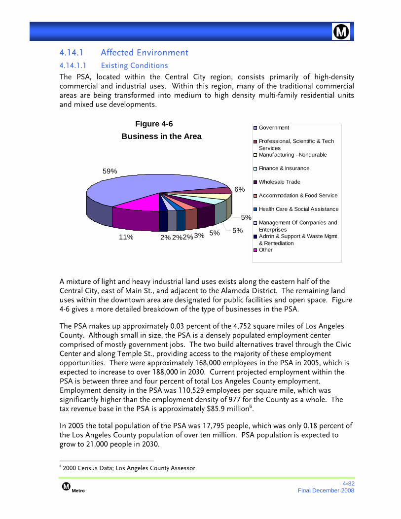


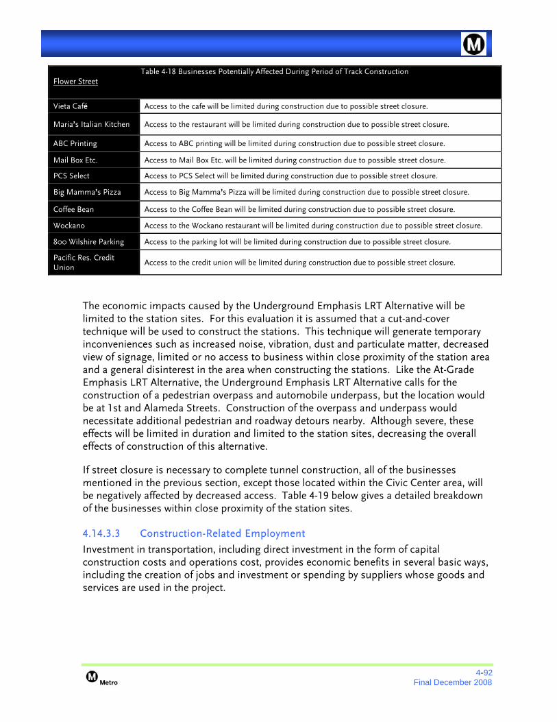


![September 1, 2011 - Appendix D: Formal Written Scoping Letters …media.metro.net/projects_studies/route_710/images/... · 2013. 4. 17. · From: Darrell Clarke [mailto:darrclarke@gmail.com]](https://static.documents.pub/doc/80x56/6147dbeca830d0442101b570/september-1-2011-appendix-d-formal-written-scoping-letters-mediametronetprojectsstudiesroute710images.jpg)


