CHAPTER IIPROTECTION OF PARTICULAR PLACES AND TERRITORIES
DIVISION IGENERAL
Prohibited forest development activities...................................................§ 1. — 3Strips of woodland.....................................................................................§ 2. — 7Visual setting.............................................................................................§ 3. — 12Maintenance of an area of stands on islands, in outfitting operations
with exclusive rights, controlled zones and wildlife sanctuaries......................§ 4. —
15Protection of certain trails........................................................................§ 5. — 17
DIVISION IISPECIAL PROVISIONS APPLICABLE TO NATIVE PORTAGE TRAILS,NATIVE CAMPGROUNDS AND NATIVE GATHERING OR SOJOURNAREAS................................................................................................................ 19
CHAPTER IIIPROTECTION OF AQUATIC ENVIRONMENTS, RIPARIAN AREAS,WETLANDS AND SOILS
DIVISION IBEDS OF LAKES AND WATERCOURSES..................................................... 25
DIVISION IIOPEN PEAT BOGS (UNWOODED) WITH A POND, MARSHES,RIPARIAN SHRUB SWAMPS, LAKES AND PERMANENTWATERCOURSES............................................................................................. 27
DIVISION IIIRIPARIAN SHRUB SWAMPS, OPEN PEAT BOGS (UNWOODED)WITHOUT A POND AND INTERMITTENT WATERCOURSES.................. 33
DIVISION IVSYLVICULTURAL DRAINAGE, WASHING WATER, CONTAMINANTS,EARTH AND TREE DEBRIS
Sylvicultural drainage ditch......................................................................§ 1. — 35Discharge, recovery and treatment of washing water...............................§ 2. — 38Discharge of contaminants and earth and removal of trees or tree
General......................................................................................................§ 1. — 63Prohibited construction, improvement or repair.......................................§ 2. — 66Road implantation features.......................................................................§ 3. — 71Stabilization of excavated soils and road embankments and diversion of
73Maintenance and closure of a road...........................................................§ 5. — 80Winter roads..............................................................................................§ 6. — 82Control of the access of motorized vehicles to sugar bushes....................§ 7. — 84
General......................................................................................................§ 1. — 86Prohibited construction, improvement or repair.......................................§ 2. — 87Drying of work area..................................................................................§ 3. — 93General provisions applicable to bridges or culverts...............................§ 4. — 95Special provisions applicable to bridges or culverts with an arch...........§ 5. — 107Special provisions applicable to removable structures and rudimentary
110Stabilization of the bed, banks and riparian zone of a watercourse.........§ 7. — 114
DIVISION IVROAD SIGNS
Provisions applicable to roads..................................................................§ 1. — 115Provisions applicable to bridges...............................................................§ 2. — 117
DIVISION VSANDPITS
Scope.........................................................................................................§ 1. — 118Sandpit operating area and organic matter storage area.........................§ 2. — 119
DIVISION VIPILING AREAS, FOREST CAMPS AND FACILITES USED TOOPERATE A SUGAR BUSH
Piling area.................................................................................................§ 1. — 124Forest camps.............................................................................................§ 2. — 128Facilities used to operate a sugar bush.....................................................§ 3. — 130
CHAPTER VIALLOCATION OF FOREST OPERATIONS AND RESIDUAL FOREST
DIVISION IGENERAL PROVISIONS APPLICABLE TO THE BIOCLIMATICDOMAINS OF THE SUGAR BUSH, THE BALSAM FIR FOREST ANDTHE SPRUCE-MOSS FOREST......................................................................... 131
DIVISION IISPECIAL PROVISIONS APPLICABLE TO THE BIOCLIMATICDOMAINS OF THE SUGAR BUSH AND THE BALSAM FIR FOREST
Total cutting...............................................................................................§ 1. — 133Total cutting other than block cutting.......................................................§ 2. — 136Block cutting..............................................................................................§ 3. — 138
DIVISION IIISPECIAL PROVISIONS APPLICABLE TO THE BIOCLIMATICDOMAIN OF THE SPRUCE-MOSS FOREST................................................. 144
CHAPTER VIIHARVEST OPTIMIZATION, FOREST REGENERATION AND SOILPROTECTION
DIVISION IHARVEST AND OPTIMUM USE OF LIGNEOUS MATTER........................ 147
BACKFILLING, SLOPE STABILIZATION AND WORK CONCERNING BRIDGEPIERS)
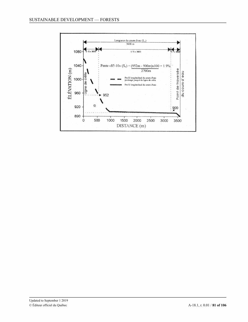
SCHEDULE 6PEAK FLOW CALCULATION METHOD FOR DRAINAGE BASINS WHOSEAREA IS EQUAL TO OR LESS THAN 60 KM
SCHEDULE 7CALCULATION METHOD FOR THE PEAK FLOW OF A DRAINAGE BASINOF AN AREA GREATER THAN 60 KM
SCHEDULE 8DIAMETER REQUIRED FOR ROUND CONDUITS ACCORDING TO THEPEAK FLOW
SCHEDULE 9CONDITIONS TO MEET FOR A CULVERT WITH A ROUND CONDUITWHERE FREE FLOW OF FISH MUST BE ENSURED
SCHEDULE 10CONDITIONS TO BE MET FOR A CULVERT WITH A CONDUIT HAVINGOUTLETS WHERE THE CONDITIONS PROVIDED FOR IN SCHEDULE 9 FORTHE LAYOUT OF A CULVERT WITH A ROUND CONDUIT MAY NOT BE MET
SCHEDULE 11CONDITIONS TO BE MET WHEN CONSTRUCTING, IMPROVING ORREPAIRING WOODEN CULVERTS
SCHEDULE 12CONDITIONS TO BE MET WHEN CONSTRUCTING, IMPROVING ORREPAIRING BRIDGES
1. This Regulation applies to forests in the domain of the State up to the northern limit of the forest tundra.
That territory is shown on the map “Vegetation areas and bioclimatic domains of Québec” reproduced inSchedule 1. The map is available on the website of the department.
473-2017
O.C. 473-2017, s. 1.
DIVISION II
INTERPRETATION
473-2017,Div.II
O.C. 473-2017, Div. II.
2. In this Regulation,“abutment” means the end support of a bridge that holds the approach fill. Abutments are made of
reinforced concrete, wood or steel caissons or a combination of stakes crowned by a portal cap beam; (culée)“accommodation centre” means a group of commercial buildings laid out on an area in a single block and
having an accommodation capacity of at least 15 persons per day; (établissement d’hébergement)“aggregated cut block” means a territory situated in a management unit in which total cutting areas with or
without recent natural disturbance zones are concentrated. The aggregated cut blocks must vary in shape andhave an area less than or equal to 150 km2. Despite the foregoing, they may be larger in the case of plans forthe protection of woodland caribou, woodland ecotype; (agglomération de coupes)
“archaeological sector” means a place where archaeological sites are concentrated and the surroundinggrounds whose geographical characteristics and situation offer an archaeological potential; (secteurarchéologique)
“archaeological site” means any site indicating prehistoric or historic human occupation and registered inthe Register of the domain of the State referred to in section 26 of the Act respecting the lands in the domainof the State (chapter T-8.1); (site archéologique)
“bank” or “shore” means the lateral part of variable steepness of the bed of a watercourse or lake that maybe submerged without the water overflowing. The upper limit of the bank is located at the top of the angle ofrepose located at the lower limit of emerged grass or, if there is no such grass, at the low limit of shrubs. Inthe absence of emerged grass and shrubs, the top of the angle of repose corresponds to the level of thebankfull discharge; (berge)
“bear den” means a site where bears hibernate. The bear dens that are to be protected are those indicated inthe numeric information layers used for forest planning; (tanière d’ours)
“bed of a watercourse” means a natural depression in the ground occupied by a permanent or intermittentwatercourse, comprising the bottom and the banks. The bed of the watercourse is free of vegetation other thanaquatic plants, if any. It shows signs or traces of waterflow, whether underground or not; (lit d’un coursd’eau)
“block cutting” means an area of total cutting or a group of areas of total cutting carried out in a giventerritory so as to preserve, within the limits of the block cutting harvest site, a residual forest having thecharacteristics set out in section 139; (coupe en mosaïque)
“block cutting harvest site” means a territory delimited by all the cutting areas for block cutting, with adistance of less than 2 km between the areas, and by a strip of land 2 km wide surrounding the whole site;(chantier de récolte en mosaïque)
“boat access route to trapping grounds” means a route that comprises rivers, lakes and portage trailsleading to trapping grounds and recognized by a Native community that includes members who use it everyyear. The boat access routes to trapping grounds that are to be protected are those indicated in the numericinformation layers used for forest planning; (parcours d’accès en embarcation aux terrains de piégeage)
“bridge” means a structure not built under embankments including abutments, sometimes piers, a deck andstabilizing materials and that allows a road to cross an obstacle, such as a watercourse; (pont)
“burial site” means a place where the body of a deceased person is interred. The burial sites that are to beprotected are those indicated in the numeric information layers used for forest planning; (site de sépulture)
“canoe-kayak-camping course” means a marked route to go down watercourses in a canoe or kayak thatincludes rivers and lakes along the banks and shores of which a number of wilderness campgrounds arelocated, and often portage trails that are developed and maintained by a government body, a municipality, theFédération québécoise du canot et du kayak or a club affiliated with that federation. The canoe-kayak-camping courses that are to be protected are those indicated in the numeric information layers used for forestplanning; (parcours de canot-kayak-camping)
“caribou calving area north of the 52nd parallel” means a caribou calving area north of the 52nd parallelwithin the meaning of section 1 of the Regulation respecting wildlife habitats (chapter C-61.1, r. 18); (aire demise bas du caribou au nord du 52e parallèle)
“cliff inhabited by a colony of birds” means a cliff inhabited by a colony of birds within the meaning ofsection 1 of the Regulation respecting wildlife habitats; (falaise habitée par une colonie d’oiseaux)
“commercial species” means a tree species referred to in Part A or Part B of Schedule 2; (essencecommerciale)
“complementary vacation site” means a site comprising at least 3 vacation lots, at the rate of at least 1 lotper 0.8 ha. Complementary vacation sites are developed to complete the development of vacation sites on theshores of a lake where the biophysical characteristics of the environment no longer make it possible to complywith the installation criteria for a grouped vacation site; (site de villégiature complémentaire)
“concentrated network of hiking trails” means a site criss-crossed by hiking trails developed forrecreational purposes, except trails intended for motorized all-terrain vehicles, at a density equal to or greaterthan 2.5 km per square kilometer; (réseau dense de sentiers de randonnée)
“continuous forest cover” means a forest cover with a density of at least 25%, characterized by a relativelyuniform space between its stems and not having any patch greater than the size of the dominant trees formingit; (couvert forestier continu)
“culvert” means a structure built under embankments including an arch or at least a conduit and stabilizingmaterials and that allows a road to cross an obstacle, such as a watercourse; (ponceau)
“cutting area” means an area in a single block where a single type of cut is used, during a single harvestyear, comprised in a development unit or in another forest of the domain of the State; (aire de coupe)
“developed campground” means a site developed for the sojourn of campers, accessible by road andhaving service areas such as shelters, toilets and parking lots. Each camping site or group of sites including nomore than 20 camping site is supplied with running water or electric power by a private or public distributionnetwork offered by the lessor of camping space; (camping aménagé)
“developed trail” means a trail, other than a trail intended for motorized all-terrain vehicles, for whichamounts were invested by the managers of an outfitting operation, a controlled zone or a wildlife sanctuary,with a view to offering services to all the users of those territories; (sentier aménagé)
“dock site with a boat ramp” means a public site with the facilities required to facilitate the comingalongside and the launching of pleasure boats, as well as its service areas, such as shelters, toilets and parkinglots; (site de quai avec rampe de mise à l’eau)
“downhill skiing station” means a site developed for the practice of downhill skiing and its service areas,such as shelters, toilets and parking lots; (station de ski alpin)
“dwelling” means any building intended for occupancy by human beings and provided with a water supplysystem and a waste water disposal system connected to the ground; (habitation)
“ecological or nature interpretation centre” means a site consisting of trails developed for educationalpurposes in connection with ecology or for purposes of discovering nature and service areas such as shelters,toilets and parking lots; (centre d’écologie ou de découverte de la nature)
“fish habitat” means a fish habitat within the meaning of section 1 of the Regulation respecting wildlifehabitats;
“fish hatchery” : means a site comprising the facilities and equipment required for the raising and breedingof fish with a view to seeding the lakes and watercourses of a region; (station piscicole)
“forest camp” : means a place where dwellings and facilities are grouped mainly for the use of workersassigned to forest development activities authorized under a forest development plan (camp forestier)
“forest cover density” means the relative ground cover by the projection of all the living branches of trees7 m tall or higher; (densité du couvert forestier)
“forest development activity” means a forest development activity within the meaning of paragraph 1 ofsection 4 of the Sustainable Forest Development Act (chapter A-18.1); however, for the purposes ofsections 3, 5, 19 to 22, 47, 50, 52, 54, 55, 57 and 59, it does not include the repair, maintenance and closure offorest roads or the control of fires, insect epidemics and cryptogamic diseases; (activité d’aménagementforestier)
“forest operations zone” means a maximum area of 250 ha, not necessarily in a single block, that is thesubject of a single sylvicultural treatment during a single harvest year, comprised in a single development unitor other forest in the domain of the State; (secteur d’intervention)
“forest stand” means a forest area of a single block of at least 30 km2, of which a minimum of 70% of theproductive forest area is constituted of timber stands 7 m or higher; (massif forestier)
“geotextile membrane” means a permeable textile, needle punched and nonwoven, having a minimumtensile strength of 1,000 newtons and interstices smaller than 150 micrometres; (membrane géotextile)
“grouped vacation site” means a site comprising at least 5 vacation lots, at the rate of at least 1 lot per0.8 ha; (site de villégiature regroupé)
“harvest year” means the period comprised between 1 April of a year and 31 March of the following year;(année de récolte)
“heritage cultural landscape” means a land area recognized by a community for its remarkable landscapefeatures, which are the result of the interaction of natural and human factors and are worth preserving and, ifapplicable, enhancing because of their historical or emblematic interest, or their value as a source of identity,within the meaning of section 2 of the Cultural Heritage Act (chapter P-9.002); (paysage culturel patrimonial)
“heritage site” means a place, a group of immovables or, in the case of a heritage site referred to insection 58 of the Cultural Heritage Act, a land area that is of interest for its archaeological, architectural,artistic, emblematic, ethnological, historical, identity, landscape, scientific, urbanistic or technological value,within the meaning of section 2 of that Act; (site patrimonial)
“heronry” means a heronry within the meaning of section 1 of the Regulation respecting wildlife habitats;(héronnière)
“holder of a forestry permit” means the holder of a forestry permit referred to in section 73 of theSustainable Forest Development Act or the third person to whom the permit holder entrusted the performanceof the work authorized by the permit; (titulaire d’un permis d’intervention)
“improvement work on a road, bridge or culvert” means work performed to improve a road or roadsegment, including the bridges and culverts, in relation to the condition it was in at the time of its constructionor latest improvement, as the case may be. In the case of a road, the work includes the following, among otherthings: operations to upgrade a road’s class, particularly by making it wider; course correction; the reductionof slopes and the addition of safety devices such as safety slides. In the case of a bridge or culvert, the workincludes, among other things: the replacement of the structure by a different structure, such as replacing aculvert with a conduit by a culvert with an arch, and alterations to the structure of a bridge to improve itsbearing capacity; (travaux d’amélioration d’un chemin, d’un pont ou d’un ponceau)
“integrated forest development plan” means a tactical plan or an operational plan referred to in section 54of the Sustainable Forest Development Act; (plan d’aménagement forestier intégré)
“intermittent watercourse” means a watercourse whose flow is intermittent and whose bed consequentlydries up during certain times of year; (cours d’eau intermittent)
“interregional trail” means a hiking trail developed for recreational purposes, linking 2 municipalities or2 regions, excluding trails intended for motorized all-terrain vehicles; (parcours interrégional de randonnées)
“island or peninsula inhabited by a colony of birds” means an island or a peninsula inhabited by a colonyof birds within the meaning of section 1 of the Regulation respecting wildlife habitats; (île ou presqu’îlehabitée par une colonie d’oiseaux)
“isolated vacation site” means land leased under section 47 of the Act respecting the lands in the domain ofthe State and intended for vacation, excluding land intended for the construction of a shelter; (site devillégiature isolé)
“landfill” means a landfill within the meaning of the Regulation respecting the landfilling and incinerationof residual materials (chapter Q-2, r. 19); (lieu d’enfouissement de matières résiduelles)
“logging machine” means a machine, motorized or not, mobile or stationary, including machines pulled bya motor vehicle, used to carry out one or more forest development activities; (engin forestier)
“maintenance work on a road, bridge or culvert” means work performed to prevent the degradation of aroad or road segment, including the bridges and culverts, so that it remains in the condition it was in at thetime of its construction or latest improvement, as the case may be. In the case of a road, the work includes,among other things: the leveling and resurfacing of the roadway provided that it does not entail the road’sreclassification; cleaning and digging ditches, the installation or replacement of drainage channels; the repairand stabilization of embankments; clearing the right-of-way of bushes to ensure visibility; spreading dustsuppressants and spreading abrasives on roads during wintertime. In the case of a bridge or culvert, the workincludes, among other things: clearing a culvert’s entrance and repairing the roadway surface and kerbs of abridge; (travaux d’entretien d’un chemin, d’un pont ou d’un ponceau)
“marsh” means land flooded permanently or temporarily, and dominated by grass growing on a mineral ororganic soil. Shrubs and trees, if any, cover less than 25% of the swamp’s area. A swamp is usually riparian,that is, adjacent to a lake or watercourse, or isolated; (marais)
“Minister” and “department” means the Minister responsible for the administration of the SustainableForest Development Act and the department within which the Minister discharges duties; (ministre andministère)
“muskrat habitat” means a muskrat habitat within the meaning of section 1 of the Regulation respectingwildlife habitats; (habitat du rat musqué)
“Native gathering or sojourn area” means an area regularly frequented by Natives and located along a boataccess route to trapping grounds or at the meeting point of a portage trail and a river or lake, identified by aNative community and indicated in the numeric information layers used for forest planning; (aire derassemblement ou de séjour autochtone)
“natural drainage” means a soil’s capacity to naturally discharge, by runoff or by infiltration into the soil,the waters brought by precipitations and the melting of snow; (drainage naturel)
“numeric information layers” means the most up-to-date numeric information layers used in the process offorest planning for the cartographic localization of places and territories in respect of which normativeprovisions are applicable; (couches d’informations numériques)
“observatory” means a site comprising facilities intended for astronomical observation and its serviceareas, such as shelters, toilets and parking lots; (observatoire)
“outdoor recreation centre” means a site developed to practise outdoor activities and its service areas, suchas shelters, toilets and parking lots; (base de plein air)
“outlying circuit of a concentrated network of hiking trails” means a hiking trail developed for recreationalpurposes, connected to a concentrated network of hiking trails, except for trails intended for motorized all-terrain vehicles; (circuit périphérique d’un réseau dense de sentiers de randonnée)
“partial cutting” means a forest cutting that takes less than 50% of the basal area of a stand at each passageand that ensures at all times the maintenance of a forest cover at least 7 m high in commercial species; (coupepartielle)
“peat bog” means a piece of land covered with moss, resulting from the accumulation of partiallydecomposed organic matter. The organic matter is at least 30 cm thick. The water table is usually at the samelevel as the soil or close to its surface. A peat bog may be open (unwooded) or wooded; in the latter case, thetrees are more than 4 m high with a cover equal to or greater than 25%. A peat bog with a pond is composedof one or more isolated bodies of water forming one or more ponds of various shapes; (tourbière)
“permanent watercourse” means a continuous watercourse whose flow is permanent and whose bedconsequently does not dry up, except during exceptional periods of drought; (cours d’eau permanent)
“pier” means an intermediate support of a bridge’s deck installed in the bed of a watercourse. Piers aremade of reinforced concrete, wood or steel caissons or a combination of stakes crowned by a portal cap beam;(pile)
“piling area” means a site used to pile timber, bark, wood shavings or forest biomass, where lopping andsawing activities may take place; (aire d’empilement)
“public beach” means a site comprising a beach, a strip of land extending 300 m inland from the shorelineand the facilities necessary for swimming and relaxation; (plage publique)
“reception station” means a place where the principal building is located, used to register, inform andsupervise users and visitors who want to have access to an outfitting operation with exclusive rights, acontrolled zone or a wildlife sanctuary; (poste d’accueil)
“removable structure” means a structure that is installed on a temporary basis to cross a watercourse;(ouvrage amovible)
“repair work on a road, bridge or culvert” means work carried out to put a degraded road or road segment,including the bridges and culverts, back in the condition it was in at the time of its construction or latestimprovement, as the case may be. In the case of a bridge or culvert, the work includes, among other things:replacing the conduit of a culvert by a new one of the same type, altering the structure of a bridge to increaseits bearing capacity such as the repair or replacement of the deck, of a part of the structure or of a part or all ofthe abutments; (travaux de réfection d’un chemin, d’un pont ou d’un ponceau)
“residual forest” means a portion of forest that remains in place following a natural disturbance, such asfire, windfall and insect epidemics, or following a man-made disturbance; (forêt résiduelle)
“rest area” means a site developed along a road corridor for rest purposes or for picnicking and its serviceareas such as shelters, toilets and parking lots; (halte routière)
“restaurant or accommodation site” means a site that includes a dwelling offering restaurant oraccommodation services on a commercial basis, or an area where an establishment has been constructedoffering lodging for hunting and fishing activities on a commercial basis; (site de restauration oud’hébergement)
“right-of-way of a road” means the surface occupied by the roadway, shoulders, ditches and embankmentsof a road, as well as the deforested strip of land on each side of the roadway. The roadway is generally locatedat the centre of the right-of-way; (emprise d’un chemin)
“riparian ecotone” means the transitional zone between the water environment and the forest, characterizedby the muscinal, herbaceous or shrubby vegetation of wetlands and sometimes including a few scattered trees;(écotone riverain)
“road corridor” means a numbered public road appearing on the official map of the Ministère desTransports and located in the bioclimatic domains of the maple or fir forest referred to in Schedule 1, or sucha road located in the bioclimatic domain of the spruce-moss forest referred to in that Schedule that links2 local municipalities or that covers a distance of no more than 50 km from the urban perimeter of a localmunicipality. That map is the map accessible on the website of the Ministère des Transports. A unnumberedpublic road giving access to an Indian reserve, to the settlements of Kitcisakik, Hunter’s Point, Pakuashipi,Oujé-Bougoumou and Winneway, to an accommodation centre or a welcome centre in an outfitting operation,a controlled zone or a wildlife sanctuary within the meaning of sections 86, 104 and 111 of the Act respectingthe conservation and development of wildlife (chapter C-61.1) is also considered a road corridor; (corridorroutier)
“salt lick” means a salt lick within the meaning of section 1 of the Regulation respecting wildlife habitats;(vasière)
“sandpit” means an open-air site where unconsolidated substances such as sand, gravel and soil areextracted. Any site to extract unconsolidated substances transported by truck is deemed to be a sandpit for thepurposes of this Regulation; (sablière)
“scenic outlook” means a site developed for the observation of nature; (belvédére)“swamp” means land subject to seasonal floods or characterized by a soil permanently or temporarily
saturated with water and dominated by a ligneous, shrub or arborescent vegetation growing on a mineral soil.The ligneous vegetal covers more than 25% of the marsh’s area. A marsh may either be riparian, that is,adjacent to a lake or watercourse, or isolated; (marécage)
“territorial reference unit” means a development unit or other forest in the domain of the State or asubdivision thereof, forming a single block, measuring less than 100 km2 in the bioclimatic domains of themaple forest, less than 300 km2 in the bioclimatic domains of the fir forest and less than 500 km2 in thebioclimatic domain of the spruce-moss forest. Those bioclimatic domains are shown in Schedule 1. Aterritorial reference unit overlapping 2 bioclimatic domains is deemed to be part of the bioclimatic domain inwhich most of the area is found; (unité territoriale de référence)
“thalweg” means the line connecting the deepest points of the bed of a watercourse; (thalweg)“total cutting” means a forest cutting carried out during one or more operations, spread over 10 years or
less, that takes once all interventions are carried out more than 80% of the basal area of the species anddiameters specified in the sylvicultural prescription of the stand; (coupe totale)
“tourist circuits or roads” means a road corridor recognized as a main interregional access road or as anitinerary proposed on one of the maps in the tourist guides published jointly by the Gouvernement du Québecand the regional tourist associations; (circuits ou routes touristiques)
“trail intended for motorized all-terrain vehicles” means a trail developed and maintained for users ofmotorized all-terrain vehicles, including snowmobile trails. The trails intended for motorized all-terrainvehicles that are to be protected are those used year after year and indicated in the numeric information layersused for forest planning; (sentier destiné aux véhicules tout terrain motorisés)
“ungroomed road” means a road free of stumps and free in whole or in part of vegetal cover, that hasundergone no earth-moving operation besides what is required to flatten its surface, and whose use is reservedfor the harvest and transportation of timber in winter time; (chemin sans mise en forme)
“visual setting” means a part of the landscape visible from a site of interest over 360 degrees at a height of1.5 m from the ground and whose limits are given by the surrounding topography; (encadrement visuel)
“water fowl gathering area” means a water fowl gathering area within the meaning of section 1 of theRegulation respecting wildlife habitats; (aire de concentration d’oiseaux aquatiques)
“water intake” means a site subject to the Regulation respecting the quality of drinking water (chapter Q-2,r. 40) that includes a structure to draw water from a watercourse, lake, reservoir or spring and the 60 m stripof woodland surrounding it; (prise d’eau)
“watercourse” means any permanent or intermittent watercourse of a hydrographic system flowing in abed, excluding the water discharged by the natural draining of the soil; (cours d’eau)
“white-tailed deer yard” means a white-tailed deer yard within the meaning of section 1 of the Regulationrespecting wildlife habitats; (aire de confinement du cerf de Virginie)
“wilderness campground” means a site established for the sojourn of campers, not supplied with runningwater or electric power by a private or public distribution network, and offering a lower quantity and qualityof the other services; (camping rustique)
“winter road” means a temporary road summarily groomed and developed mainly for harvesting wood inwinter; (chemin d’hiver)
“wooden culvert” means a culvert with a wooden arch; (ponceau de bois)“work to build a road, bridge or culvert” means work performed to build a road or road segment at a new
place, including work to build bridges and culverts on that road; (travaux de construction d’un chemin, d’unpont ou d’un ponceau)
“work to close a road” means work to prevent access to a road or road segment on a permanent ortemporary basis. (travaux de fermeture d’un chemin)
For the purposes of this Regulation, an outdoor recreation centre, a scenic outlook, a developedcampground, a wilderness campground, an ecological or nature interpretation centre, a cottage that offerslodging and operated on a commercial basis by the manager of an outfitting operation, a controlled zone or awildlife sanctuary, an outlying circuit of a concentrated network of hiking trails, an accommodation centre, arest area, a landfill, an observatory, an interregional trail, a public beach, a reception station, a water intake, aconcentrated network of hiking trails, a trail intended for motorized all-terrain vehicles, a dock site with a boatramp, a restaurant or accommodation site, a vacation site, a downhill skiing station and a fish hatchery arethose for which a right has been granted under a law or regulation of the Government.
473-2017
O.C. 473-2017, s. 2.
CHAPTER II
PROTECTION OF PARTICULAR PLACES AND TERRITORIES
473-2017,c.II
O.C. 473-2017, c. II.
DIVISION I
GENERAL
473-2017,Div.I
O.C. 473-2017, Div. I.
§ 1. — Prohibited forest development activities
473-2017,Sd.1
O.C. 473-2017, Sd. 1.
3. No forest development activity may be carried out in the following places and territories:
(1) a protected area, proposed or permanent, of Category I, II or III of the International Union forConservation of Nature, constituted in accordance with the Natural Heritage Conservation Act (chapter
C-61.01) or the Parks Act (chapter P-9) and entered in the register of protected areas, unless the carrying outof the activity is authorized under one of those Acts or pursuant to them;
(2) an outdoor recreation centre;
(3) a scenic outlook;
(4) a developed campground;
(5) a wilderness campground;
(6) an accommodation centre;
(7) a rest area;
(8) an island whose area is less than 250 ha;
(9) an observatory;
(10) a public beach;
(11) a water intake;
(12) an archeological site;
(13) a dock site with a boat ramp;
(14) a restaurant or accommodation site;
(15) a burial site;
(16) a complementary vacation site;
(17) an isolated vacation site or other land leased under section 47 of the Act respecting the lands in thedomain of the State (chapter T-8.1);
(18) a grouped vacation site;
(19) a projected site or place, referred to in subparagraphs 2 to 4, 6, 10, 13, 14, 16, 18 and 20, andindicated in a regional plan for the development of the public territory – recreation and tourism sector - or in aregional plan for integrated land and resource development;
(20) a downhill skiing station;
(21) a fish hatchery.
The first paragraph does not apply to archeological sites where the Minister has allowed, under theSustainable Forest Development Act (chapter A-18.1), forest development activities to be carried out. Theperson carrying out the activities must however leave the soil intact. Furthermore, that person must harvesttrees when the ground is frozen at a depth of at least 35 cm.
Before allowing forest development activities to be carried out on an archaeological site other than a sitelocated in a classified or declared heritage site entered in the cultural heritage register referred to in section 5of the Cultural Heritage Act (chapter P-9.002), the Minister consults the Minister responsible for theadministration of that Act to obtain his or her opinion on the cultural interest of the site.
The carrying out of forest development activities on a classified or declared heritage site requires theauthorizations provided for in the Cultural Heritage Act.
473-2017
O.C. 473-2017, s. 3.
4. A person who carries out forest development activities in an archaeological sector must leave the soilintact. Furthermore, the person must harvest trees when the ground is frozen at a depth of at least 35 cm.
This section does not apply to archeological sites where the Minister has allowed, under the SustainableForest Development Act (chapter A-18.1), forest development activities to be carried out on conditionsdifferent from those provided for in the first paragraph.
Before allowing forest development activities to be carried out on an archaeological site on conditionsdifferent from those provided for in the first paragraph, the Minister consults the Minister responsible for theadministration of the Cultural Heritage Act (chapter P-9.002) to obtain his or her opinion on the culturalinterest of the sector.
473-2017
O.C. 473-2017, s. 4.
5. Where a trapping camp erected under section 88 of the Act respecting the conservation and developmentof wildlife (chapter C-61.1) is permanently installed in a development unit or other forest in the domain of theState, no forest development activity may be carried out over an area of 4,000 m2, including the camp area.
The camp must be indicated in the numeric information layers used for forest planning.
This section does not apply to the holder of a forestry permit issued for wildlife, recreational or agriculturaldevelopment projects or issued for public utility works, nor to the holder of a forestry permit issued for forestdevelopment activities carried out by the holder of mining rights for the purposes of exercising his or herrights, unless the mining activities are to extract surface mineral substances, or when the area affected by theforest development activities occupies more than 10% of the area referred to in the first paragraph.
473-2017
O.C. 473-2017, s. 5; I.N. 2019-01-01.
6. Subparagraphs 2 to 10 and 13 to 21 of the first paragraph of section 3 do not apply to the holder of aforestry permit issued for forest development activities carried out by the holder of mining rights for thepurposes of exercising his or her rights, unless the mining activities are to extract surface mineral substances,nor to the holder of a forestry permit issued for wildlife, recreational or agricultural development projects.
Subparagraphs 2 to 11 and 13 to 21 of the first paragraph of section 3 do not apply to a holder of a forestrypermit issued for public utility works.
473-2017
O.C. 473-2017, s. 6.
§ 2. — Strips of woodland
473-2017,Sd.2
O.C. 473-2017, Sd. 2.
7. A strip of woodland at least 60 m in width must be preserved around the following places and territories:
(1) an ecological reserve established under the Natural Heritage Conservation Act (chapter C-61.01), aproposed ecological reserve provided for in that Act or a national park established under the Parks Act(chapter P-9), except where the limit of the area is a road;
(6) a cottage that offers lodging and operated on a commercial basis by the manager of an outfittingoperation, a controlled zone or a wildlife sanctuary;
(7) an accommodation centre;
(8) a rest area;
(9) the facilities in place in an ecological or nature interpretation centre or a concentrated network ofhiking trails;
(10) an observatory;
(11) a reception station;
(12) a refuge erected on land in respect of which a right has been issued under the Act respecting thelands in the domain of the State (chapter T-8.1) or under sections 88 and 118 of the Act respecting theconservation and development of wildlife (chapter C-61.1) and used as a shelter by users of an outlyingcircuit of a concentrated network of hiking trails, an interregional trail, a concentrated network of hiking trailsand users of a trail intended for motorized all-terrain vehicles;
(13) a dock site with a boat ramp;
(14) a restaurant or accommodation site;
(15) a complementary vacation site;
(16) an isolated vacation site;
(17) a grouped vacation site;
(18) a classified heritage site entered in the register of cultural heritage referred to in section 5 of theCultural Heritage Act (chapter P-9.002).
473-2017
O.C. 473-2017, s. 7.
8. A strip of woodland at least 30 m wide must be preserved around the following places and territories:
(1) a sugar bush;
(2) a landfill;
(3) a burial site.
A strip of woodland at least 30 m in width must also be kept on each side of the following roads and trails:
(1) a road identified as a road corridor, unless the sylvicultural treatment carried out where the road islocated is total cutting carried out according to the conditions of block cutting, or partial cutting;
(2) a hiking trail forming part of an ecological or nature interpretation centre or a concentrated network ofhiking trails;
(3) an access trail to a scenic outlook, an outlying circuit of a concentrated network of hiking trails or aninterregional trail, specifically deforested for those purposes;
(4) a portage trail included in a canoe-kayak-camping course, specifically deforested for those purposes;
(5) a developed trail.
The strip of woodland of a road identified as a road corridor must be maintained until regeneration isestablished in the cutting area adjacent to that strip of woodland and has reached an average height of 3 m.
473-2017
O.C. 473-2017, s. 8.
9. A partial harvest not exceeding 40% of the merchantable stems, in the case of stands of species referredto in Part A of Schedule 2, or 40% of the basal area in the case of stands of species referred to in Part B of thatSchedule, is however allowed in the strip of woodland when forest operations are carried out on the adjacentland.
However, the density of the stand may never be reduced to less than 700 merchantable stems/ha, in thecase of stands of species referred to in Part A of Schedule 2, or the basal area may not be reduced to less than16 m2/ha, in the case of stand of species referred to in Part B of that Schedule.
Despite the first and second paragraphs, where the sylvicultural prescription provides for partial cutting inthe stand adjacent to the strip of woodland referred to in sections 7 and 8, the harvest level indicated in thesylvicultural prescription of the adjacent stand then applies to that strip of woodland.
Residual trees in the strip of woodland must be spread uniformly so as to constitute a visual screen andcontribute to maintain the forest ambiance and the function of the place or territory concerned.
Total cutting is prohibited in the strip of woodland.
473-2017
O.C. 473-2017, s. 9.
10. In a strip of woodland kept along a road identified as a road corridor, an outlying circuit of aconcentrated network of hiking trails, an interregional trail or a portage trail included in a canoe-kayak-camping course, a felling and hauling trail or other road may be constructed only at a distance of more than250 m from another felling and hauling trail or another road. Deforestation for that purpose may not exceedthe width of the felling and hauling trail or the width of the road, including the roadway, embankments andditches.
473-2017
O.C. 473-2017, s. 10.
11. Sections 7 to 10 do not apply to the holder of a forestry permit issued for public utility works.
473-2017
O.C. 473-2017, s. 11.
§ 3. — Visual setting
473-2017,Sd.3
O.C. 473-2017, Sd. 3.
12. A visual setting of 1.5 km must be preserved along tourist circuits or routes and around the followingplaces and territories:
(1) a rest area;
(2) a public beach;
(3) a dock site with a boat ramp when it includes in its service areas restaurant and accommodationfacilities;
(4) a proposed site or place, referred to in paragraphs 2 and 3 and indicated in the regional plan for thedevelopment of the public territory – recreation and tourism sector – or in a regional plan for integrated landand resource development;
(5) a heritage site declared by the Government under the Cultural Heritage Act (chapter P-9.002).
473-2017
O.C. 473-2017, s. 12.
13. A visual setting of 3 km must be preserved around the following places and territories:
(1) an outdoor recreation centre;
(2) a scenic outlook;
(3) a developed campground with at least 8 camping lots;
(4) an accommodation centre;
(5) the boundaries of a town;
(6) a reception station;
(7) a complementary vacation site;
(8) a grouped vacation site;
(9) a projected site or place, referred to in paragraphs 1 to 4, 6 to 8 and 10 and indicated in the regionalplan for the development of the public territory – recreation and tourism sector – or in a regional plan forintegrated land and resource development;
(10) a downhill skiing station.
473-2017
O.C. 473-2017, s. 13.
14. Partial cutting with maintenance of a continuous forest cover is allowed throughout the visual settingor in a heritage cultural landscape. Partial cutting without maintenance of a continuous forest cover isprohibited.
Total cutting is also allowed in a visual setting, except total cutting with a harvest pattern by harvest stripsmore than 6 m in width or by blocks with a straight contour. However, all the areas where the allowed totalcutting is carried out must cover at least the third of the area of the visual setting during each third of theexpected period of rotation of the stands, in order to preserve at all times the quality of the landscape.
Total cutting is prohibited in a heritage cultural landscape designated by the Government under theCultural Heritage Act (chapter P-9.002).
This section does not apply to the holder of a forestry permit issued for public utility works.
§ 4. — Maintenance of an area of stands on islands, in outfitting operations with exclusive rights, controlledzones and wildlife sanctuaries
473-2017,Sd.4
O.C. 473-2017, Sd. 4.
15. At least 30% of the productive forest area constituted of stands of 7 m or more in height must bepreserved at all times on an island of 250 to 500 ha.
473-2017
O.C. 473-2017, s. 15.
16. At least 30% of the productive forest area constituted of stands of 7 m or more in height must bepreserved at all times in an outfitting operation with exclusive rights, in a controlled zone or in a wildlifesanctuary.
In addition, at least 30% of the productive forest area constituted of stands of 7 m or more in height mustbe preserved in the following territories or portions of territory:
(1) in each territorial reference unit or portion thereof at least 30 km2 included in an outfitting operationwith exclusive rights, in a controlled zone or in a wildlife sanctuary and situated in the bioclimatic domains ofthe maple forest and fir forest;
(2) in each aggregated cut block or part thereof at least 30 km2 included in an outfitting operation withexclusive rights, in a controlled zone or in a wildlife sanctuary and situated in the bioclimatic domain of thespruce-moss forest.
473-2017
O.C. 473-2017, s. 16.
§ 5. — Protection of certain trails
473-2017,Sd.5
O.C. 473-2017, Sd. 5.
17. The following trails may not be used for hauling or trucking purposes:
(1) hiking trails forming part of an ecological or nature interpretation centre or of a concentrated networkof hiking trails;
(2) access trails to a scenic outlook and hiking trails of an outlying circuit of a concentrated network ofhiking trails or interregional trail, deforested specifically for those purposes;
(3) trails intended for motorized all-terrain vehicles, portage trails of boat access route to trappinggrounds and portage trails comprised in a canoe-kayak-camping course, developed specifically or thosepurposes;
(4) developed trails.
473-2017
O.C. 473-2017, s. 17.
18. All trees or parts thereof that fall on a trail during the carrying out of forest development activitiesmust be removed. The pilling and windrowing of logging residues is prohibited on a trail.
Where a trail is damaged because of a forest development activity carried out near a trail, in particularduring hauling, the trail must be put back in the condition it was in before the carrying out of the activity.
This section applies to all the trails referred to in section 17.
SPECIAL PROVISIONS APPLICABLE TO NATIVE PORTAGE TRAILS, NATIVE CAMPGROUNDSAND NATIVE GATHERING OR SOJOURN AREAS
473-2017,Div.II
O.C. 473-2017, Div. II.
19. No forest development activity may be carried out on a Native portage trail. However, it is allowed tobuild or improve a road that crosses a Native portage trail.
A strip of woodland at least 30 m wide must be preserved on each side of Native portage trails so as tocreate a visual setting and to maintain the forest ambiance of the site.
The provisions of section 9 respecting partial cutting applies to that strip of woodland kept on each side ofNative portage trails.
This section does not apply to the holder of a forestry permit issued for forest development activitiescarried out by the holder of mining rights to exercise those rights, unless the mining activities are to extractsurface mineral substances.
473-2017
O.C. 473-2017, s. 19.
20. Where a campground established under the Act respecting hunting and fishing rights in the James Bayand New Québec territories (chapter D-13.1) is installed on a trapping ground situated in a development unitor other forest of the domain of the State, no forest development activity may be carried out over an area of40,000 m2, including the campground area.
The foregoing also applies to a Native campground used to trap in a beaver reserve and situated in adevelopment unit or other forest of the domain of the State.
This section applies to a campground per 100 km2 of trapping ground.
473-2017
O.C. 473-2017, s. 20.
21. Where a Native campground or group of campgrounds not referred to in the second paragraph ofsection 20 is installed on the territory of a beaver reserve, no forest development activity may be carried outover an area of 4,000 m2, including the area of the campground or group of campgrounds.
This section applies to a maximum of 2 campgrounds or 2 groups of campgrounds per 100 km2 of trappingground.
473-2017
O.C. 473-2017, s. 21.
22. Where a Native gathering or sojourn area is located in a development unit or other forest in the domainof the State, no forest development activity may be carried out on an area 40 m wide and 100 m longalongside a lake or watercourse near those areas. That area includes the area of the strip of woodland keptalongside the lake or watercourse.
473-2017
O.C. 473-2017, s. 22.
23. Sections 19 to 22 do not apply to the holder of a forestry permit issued for wildlife, recreational oragricultural development projects.
24. Native portage trails and Native gathering or sojourn areas referred to in sections 19 to 22 must beindicated in the numeric information layers used for forest planning after having been recognized by theNative band council concerned.
473-2017
O.C. 473-2017, s. 24.
CHAPTER III
PROTECTION OF AQUATIC ENVIRONMENTS, RIPARIAN AREAS, WETLANDS AND SOILS
473-2017,c.III
O.C. 473-2017, c. III.
DIVISION I
BEDS OF LAKES AND WATERCOURSES
473-2017,Div.I
O.C. 473-2017, Div. I.
25. The travel of logging machines is prohibited on the bed of a lake.
Despite the foregoing, the travel of logging machines is allowed on the bed of a lake to construct, improveor repair a road, bridge or culvert to cross a lake if such work is authorized as part of an activity or project forwhich a certificate of authorization was issued following a decision of the authority concerned made undersection 31.5, 164 or 201 of the Environment Quality Act (chapter Q-2).
473-2017
O.C. 473-2017, s. 25.
26. The travel of logging machines is prohibited on the bed of a watercourse, except to construct orremove a bridge or culvert or to place or remove a removable structure. In that case, only one round trip of thelogging machine in the watercourse is then allowed on the site of the installation and no work may be donefrom the bed of the watercourse.
The travel of logging machines is also allowed on the bed of a watercourse to carry out work to installcoffer dams and structures to temporarily divert the watercourse, in accordance with section 93.
This section does not apply to the travel of logging machines used to carry out vegetation control activitiesby the holder of a forestry permit issued for public utility works. However, passing through the fish habitatrequires the prior issue of the authorizations required under the Act respecting the conservation anddevelopment of wildlife (chapter C-61.1).
473-2017
O.C. 473-2017, s. 26.
DIVISION II
OPEN PEAT BOGS (UNWOODED) WITH A POND, MARSHES, RIPARIAN SHRUB SWAMPS, LAKESAND PERMANENT WATERCOURSES
473-2017,Div.II
O.C. 473-2017, Div. II.
27. A strip of woodland at least 20 m wide must be preserved alongside a peat bog with a pond, a marsh,riparian shrub swamp, lake or permanent watercourse.
The strip of woodland is measured from the limit that separates the stand from the environment to beprotected or, in the presence of a riparian ecotone, from the limit of the ecotone farthest from the environmentto be protected. The strip of woodland must be linked to the residual forest.
473-2017
O.C. 473-2017, s. 27.
28. A maximum partial harvest of 40% of merchantable stems, in the case of stands of the species referredto in Part A of Schedule 2, or 40% of the basal area, in the case of stands of the species referred to in Part B ofthat Schedule, is however allowed in the strip of woodland if the slope degree is less than 30%.
However, the density of the stand may never be reduced to less than 700 merchantable stems/ha, in thecase of stands of the species referred to in Part A of Schedule 2, or the basal area may not be reduced to lessthan 16 m2/ha, in the case of stands of the species referred to in Part B of that Schedule.
Despite the first and second paragraphs, where the sylvicultural prescription provides for partial cutting inthe stand adjacent to the strip of woodland referred to in section 27, the harvest level indicated in theprescription for the adjacent stand then applies to the strip of woodland.
The residual trees in the strip of woodland must be spread evenly to ensure the protection of aquaticenvironments, riparian areas and wetlands.
Total cutting is prohibited in the strip of woodland.
473-2017
O.C. 473-2017, s. 28.
29. Sections 27 and 28 do not apply to the holder of a forestry permit issued for forest developmentactivities carried out by a holder of mining rights where the holder carries out mining exploration work, to theholder of a forestry permit issued for wildlife, recreational or agricultural development projects, nor to theholder of a forestry permit issued for public utility works, nor to the construction, improvement or repair of aroad.
However, the holder of a development permit issued for public utility works who installs a powertransmission line or a gas pipeline requiring the deforestation of the strip of woodland must preserve thestumps, shrubs and grass in that strip, or reestablish such vegetation.
473-2017
O.C. 473-2017, s. 29.
30. Despite section 27, the holder of a mining right to whom a forestry permit was issued who lays out anaccess to an open peat bog with a pond, to a marsh, to a riparian shrub swamp, to a lake or to a permanentwatercourse in order to carry out mining exploration work or to install equipment required for such work mayclear an opening not wider than 5 m in the strip of woodland.
The stumps, grass and advance growth must be preserved in that opening.
473-2017
O.C. 473-2017, s. 30.
31. Despite section 27, a maximum of 3 visual openings may be cleared in the strip of woodland where aforest camp is established near a peat bog with a pond, a marsh, a riparian shrub swamp, a lake or apermanent watercourse. The width of each opening must not exceed 10% of the length of the strip ofwoodland separating the camp from those environments.
The stumps, grass and advance growth must be preserved in those openings.
Only one road not exceeding 5 m in width and leading to the environments referred to in the firstparagraph may be developed for all the openings.
473-2017
O.C. 473-2017, s. 31.
32. The travel of logging machines is prohibited in the riparian ecotone when the latter is present andwithin the first 20 metres of a strip of woodland kept alongside an open peat bog with a pond, a marsh, ariparian shrub swamp, a lake or a permanent watercourse, except in the following cases:
(1) to dig drainage ditches for sylvicultural purposes;
(2) to take a felling and hauling trail across a watercourse by means of a removable structure;
(3) to carry out a wildlife development project authorized under a forestry permit, provided that thedevelopment project is carried out in accordance with the conditions set out in the permit;
(4) to construct, improve or repair a road or remove a structure used to cross a watercourse;
(5) to carry out public utility works.
473-2017
O.C. 473-2017, s. 32.
DIVISION III
RIPARIAN SHRUB SWAMPS, OPEN PEAT BOGS (UNWOODED) WITHOUT A POND ANDINTERMITTENT WATERCOURSES
473-2017,Div.III
O.C. 473-2017, Div. III.
33. Harvesting is prohibited in the riparian shrub swamps whose ecological type is one of the followingforests:
(1) silver maple, elm, ash forest (FO18);
(2) black ash, fir forest on hydric drainage (MF18);
(3) yellow birch, fir, sugar maple forest on hydric drainage (MJ18);
(4) fir, yellow birch forest on hydric drainage (MS18);
(5) fir, red maple forest on hydric drainage (MS68);
(6) fir, white cedar forest (RS18).
Harvesting is allowed in riparian shrub swamps whose ecological type is not one of those referred to in thefirst paragraph. However, the travel of logging machines during harvest may not result in the natural drainageof the soil being disturbed.
This section does not apply to the holder of a forestry permit issued for wildlife, recreational or agriculturaldevelopment projects who carries out forest management activities required for wildlife development projects,nor to the holder of a forestry permit issued for public utility works.
473-2017
O.C. 473-2017, s. 33.
34. The travel of logging machines is prohibited over a width of at least 6 m alongside an open peat bogwithout a pond or an intermittent watercourse, except in any of the cases provided for in paragraph 1, 2, 4 or 5
of section 32. The 6 m-width is measured from the perimeter of the peat bog or the upper limit of the bank ofthe intermittent watercourse.
Harvesting is however allowed in that 6 m strip of land. However, the vegetal cover and the stumps mustbe preserved to minimize disturbances in the soil and water regime.
473-2017
O.C. 473-2017, s. 34.
DIVISION IV
SYLVICULTURAL DRAINAGE, WASHING WATER, CONTAMINANTS, EARTH AND TREE DEBRIS
473-2017,Div.IV
O.C. 473-2017, Div. IV.
§ 1. — Sylvicultural drainage ditch
473-2017,Sd.1
O.C. 473-2017, Sd. 1.
35. Despite section 27, an opening not wider than 5 m in the strip of woodland referred to in that sectionmay be cleared to dig a drainage ditch for sylvicultural purposes.
473-2017
O.C. 473-2017, s. 35.
36. A ditch or network of sylvicultural drainage ditches must have a settling pond at its outlet.
The ditch or network of sylvicultural drainage ditches and the settling pond must not allow for theintroduction of sediments into an open peat bog with a pond, a marsh, a riparian swamp, a lake or awatercourse, nor over a width of 20 m, measured from the limit that separates the stand from the environmentto be protected or, in the presence of a riparian ecotone, from the limit of the ecotone farthest from theenvironment to be protected.
473-2017
O.C. 473-2017, s. 36.
37. The settling pond must remain operational and be drained when the water height above the sedimentsis less than 30 cm over at least 50% of the settling pond’s area.
473-2017
O.C. 473-2017, s. 37.
§ 2. — Discharge, recovery and treatment of washing water
473-2017,Sd.2
O.C. 473-2017, Sd. 2.
38. Washing logging machines is prohibited in a forest if it takes place at 60 m or less from an open peatbog, a swamp, a riparian marsh, a lake or a watercourse. The 60-m distance is measured from the perimeter ofthe peat bog, marsh or swamp or from the upper limit of the shore of a lake or bank of a watercourse or, in thepresence of a riparian ecotone, from the limit of the ecotone farthest from the environment to be protected.
473-2017
O.C. 473-2017, s. 38.
39. Water for washing logging machines may be discharged in the forest only if all the followingconditions are met:
(1) washing is not done at the top of a slope leading directly to an open peat bog, a marsh, a swamp, alake or a watercourse;
(3) washing is done using high pressure equipment and without degreasing agents;
(4) a geotextile membrane is placed under the logging machine to collect the residues dislodged bywashing;
(5) the geotextile membrane and dislodged residues must be recovered and disposed of in accordancewith the Regulation respecting hazardous materials (chapter Q-2, r. 32).
Despite the first paragraph, washing water may be discharged in the forest provided that it is treated on thesite and that it does not contain more than 30 mg/l of suspended matter and 15 mg/l of hydrocarbons (C10-C50).
Residues from washing and water treatment on the site must be recovered and disposed of in accordancewith applicable laws and regulations.
473-2017
O.C. 473-2017, s. 39.
40. Water for washing logging machines that may not be discharged in the forest must be recovered and betreated in accordance with applicable laws and regulations.
473-2017
O.C. 473-2017, s. 40.
41. The owner of the logging machine must obtain from the enterprise that treats the washing water on thesite a certificate of compliance with the standards provided for in the second paragraph of section 39 beforethe washing water may be discharged in the forest.
The certificate must contain the name and address of the enterprise that has treated the washing water onthe site and the signature of the person who, within that enterprise, has treated the water, the name, addressand signature of the logging machine’s owner or his or her representative, the GPS positioning data of thewashing site and the volume of water treated and discharged in the forest.
The certificate must be preserved for at least one year and be submitted, upon request, to the Minister.
473-2017
O.C. 473-2017, s. 41.
§ 3. — Discharge of contaminants and earth and removal of trees or tree debris
473-2017,Sd. 3
O.C. 473-2017, Sd. 3.
42. The discharge of hydrocarbons, chemicals or other similar contaminants is prohibited in the forestwhen carrying out a forest development activity.
473-2017
O.C. 473-2017, s. 42.
43. During a forest development activity, the discharge of earth is prohibited in an open peat bog, a swamp,a marsh, a lake or a watercourse.
This section does not apply to the discharge of earth during the construction, improvement or repair of aroad where those activities are carried out in accordance with this Regulation, except the portion of asnowmobile trail crossing a lake or its ecotone.
473-2017
O.C. 473-2017, s. 43.
44. Any person who carries out a forest development activity alongside an open peat bog with a pond, amarsh, a riparian shrub swamp, a lake or a watercourse must remove all trees or tree parts that fall into thoseenvironments during the carrying out of the activity.
This section does not apply to vegetation control activities carried out by the holder of a forestry permitissued for public utility works where trees or parts of trees fall in an open peat bog with a pond, a marsh or ariparian shrub swamp.
473-2017
O.C. 473-2017, s. 44.
DIVISION V
SOILS
473-2017,Div.V
O.C. 473-2017, Div. V.
45. The ruts created in the falling and hauling trails during forest operations must not appear over morethan 25% of the length of trails per total cutting area.
For the purposes of this section, a rut is a trace dug in the ground by the wheels or tracks of loggingmachines assigned to land preparation or to operations to harvest, haul, pile or load timber, and that is at least4 m in length. On organic soil, a torn vegetal cover is considered as a rut. On mineral soil, a rut is more than200 mm deep, measured from the mineral soil that it not disturbed by the logging machine.
473-2017
O.C. 473-2017, s. 45.
46. In forest stands belonging to the ecological subregions and ecological types indicated in Schedule 3,tree branches must be left on the falling site, near the stump, to prevent a loss in soil fertility in the long term.
473-2017
O.C. 473-2017, s. 46.
CHAPTER IV
WILDLIFE HABITAT PROTECTION
473-2017,c.IV
O.C. 473-2017, c. IV.
DIVISION I
PROHIBITED FOREST DEVELOPMENT ACTIVITIES
473-2017,Div.I
O.C. 473-2017, Div. I.
47. No forest development activity may take place in the following wildlife habitats:
(1) a caribou calving area north of the 52nd parallel;
(2) a cliff inhabited by a colony of birds;
(3) a muskrat habitat;
(4) the site where a heronry’s nests are located;
(5) an island or peninsula inhabited by a colony of birds;
(6) a salt lick.
473-2017
O.C. 473-2017, s. 47.
48. The following forest development activities are prohibited in a waterfowl gathering area:
(1) the application of pesticides to control insect epidemics and cryptogamic diseases;
(2) the application of phytocides;
(3) the construction of roads;
(4) the digging of a drainage ditch for sylvicultural purposes.
The foregoing also applies to tree pruning, felling or harvesting and preparatory work for forest productionpurposes in the floodplain of a waterfowl gathering area, subject to the third paragraph..
From 16 December to 14 March, partial cutting not exceeding 30% of the merchantable stems present,carried out over a 10-year period, is allowed in a floodplain of a waterfowl gathering area.
473-2017
O.C. 473-2017, s. 48.
49. Section 47 and the second and third paragraphs of section 48 do not apply to the holder of a forestrypermit issued for forest development activities carried out by the holder of mining rights for the purposes ofexercising his or her rights, unless the mining activities are to extract surface mineral substances, nor to theholder of a forestry permit issued for wildlife, recreational or agricultural development projects.
Sections 47 and 48 do not apply to the holder of a forestry permit issued for public utility works. However,before forest development activities required for public utility works and not authorized by sections 47 and 48may be carried out in all or part of the wildlife habitats referred to in those sections, the Minister consults theMinister responsible for the administration of the Act respecting the conservation and development of wildlife(chapter C-61.1) before issuing the permit.
473-2017
O.C. 473-2017, s. 49.
DIVISION II
STRIPS OF WOODLAND
473-2017,Div.II
O.C. 473-2017, Div. II.
§ 1. — White-tailed deer yards
473-2017,Sd.1
O.C. 473-2017, Sd. 1.
50. Despite the provisions of sections 28 and 30 to 32, no forest development activity is allowed within thefirst 20 metres of the strip of woodland kept alongside an open peat bog with a pond, a marsh, a riparian shrubswamp, a lake or a permanent watercourse located in a white-tailed deer yard.
473-2017
O.C. 473-2017, s. 50.
51. Where the strip of woodland referred to in section 50 is made wider than 20 m to fulfill the needs ofthe white-tailed deer habitat, only partial cutting not exceeding 40% of the merchantable stems, in the case ofstands of species referred to in Part A of Schedule 2, or 40% of the basal area in the case of stands of speciesreferred to in Part B of that Schedule, is allowed beyond the first 20 metres of the strip of woodland.
In addition, the density of the stand may never be reduced to less than 700 merchantable stems/ha, in thecase of stands of species referred to in Part A of Schedule 2, or the basal area may not be reduced to less than16 m2/ha, in the case of stand of species referred to in Part B of that Schedule.
Despite the first and second paragraphs, where the sylvicultural prescription provides for partial cutting inthe stand adjacent to the strip of woodland referred to in section 50, the harvest level indicated in thesylvicultural prescription of the adjacent stand then applies to the widened part of that strip of woodland.
Residual trees in the widened strip of woodland where partial harvest takes place must be spread uniformlyso as to favor the renewal of the forest cover and to maintain shelters and food for the white-tailed deer.
473-2017
O.C. 473-2017, s. 51.
52. A strip of woodland at least 60 m wide and at least 7 m high linking a white-tailed deer yard to theresidual forest must be preserved and kept in place until the adjacent stands have reached an average heightof 7 m.
No forest development activity may be carried out in that strip of woodland.
In softwood and softwood-dominant mixed stands within a white-tailed deer yard, a strip of woodland atleast 60 m wide must be preserved and kept in place between 2 areas of total cutting until the dominant forestcover in those cutting areas has reached an average height of 7 m.
473-2017
O.C. 473-2017, s. 52.
53. Sections 50 and 51 do not apply to the holder of a forestry permit issued for forest developmentactivities carried out by the holder of mining rights where the holder carries out mining exploration work, norto the holder of a forestry permit issued for wildlife, recreational or agricultural development projects, nor tothe construction, improvement or repair of a road.
Sections 50 to 52 do not apply to the holder of a forestry permit issued for public utility works. However,before forest development activities required for public utility works and not authorized by sections 50 and 52may be carried out in part of a white-tailed deer yard referred to in those sections, the Minister consults theMinister responsible for the administration of the Act respecting the conservation and development of wildlife(chapter C-61.1) before issuing the permit.
473-2017
O.C. 473-2017, s. 53.
§ 2. — Heronries
473-2017,Sd.2
O.C. 473-2017, Sd. 2.
54. A strip of woodland at least 200 m wide must be preserved within a strip of 500 m surrounding the sitewhere a heronry’s nests are located. The strip of woodland is measured from the limit that separates the standfrom the site of the nests.
Forest development activities are prohibited within the first 200 m of the strip of woodland referred to inthe first paragraph. They are allowed beyond the first 200 m of that strip of woodland, but only from 1 Augustto 31 March.
The maximum width of the roadway of a road located within the limits of a heronry is 5.5 m.
The first and second paragraphs do not apply to the holder of a forestry permit issued for forestdevelopment activities carried out by the holder of mining rights for the purposes of exercising his or herrights, unless the mining activities are to extract surface mineral substances, nor to the holder of a forestrypermit issued for wildlife, recreational or agricultural development projects.
This section does not apply to the holder of a forestry permit issued for public utility works. However,before forest development activities required for public utility works and not authorized by this section maybe carried out in the part of a heronry referred to in this section, the Minister consults the Minister responsible
for the administration of the Act respecting the conservation and development of wildlife (chapter C-61.1)before issuing the permit.
473-2017
O.C. 473-2017, s. 54.
§ 3. — Salmon rivers
473-2017,Sd.3
O.C. 473-2017, Sd. 3.
55. A strip of woodland at least 60 m wide must be preserved on both sides of the river or part of a riverdesignated by the Minister as a salmon river. The strip of woodland is measured from the limit that separatesthe stand from the environment to be protected or, in the presence of a riparian ecotone, from the limit of theecotone farthest from the environment to be protected.
Forest development activities are prohibited in that strip of woodland, unless prior authorization isobtained from the Minister in accordance with section 39 of the Sustainable Forest Development Act (chapterA-18.1).
In the case of land immersed following the construction of dams, the strip of woodland begins at the limitof the land where the trees have perished as a result of the immersion.
473-2017
O.C. 473-2017, s. 55.
§ 4. — Bear dens
473-2017,Sd.4
O.C. 473-2017, Sd. 4.
56. A strip of woodland at least 60 m wide must be preserved around a bear den from 15 November to15 April.
The strip may be harvested outside that period.
The first paragraph does not apply to the holder of a forestry permit issued for public utility works.However, before forest development activities required for public utility works and not authorized by thissection may be carried out in the strip of woodland referred to in the first paragraph, the Minister consults theMinister responsible for the administration of the Act respecting the conservation and development of wildlife(chapter C-61.1) before issuing the permit.
473-2017
O.C. 473-2017, s. 56.
§ 5. — Salt licks
473-2017,Sd.5
O.C. 473-2017, Sd. 5.
57. A strip of woodland at least 60 m wide and at least 7 m high linking a the salt lick to the residual forestmust be preserved intact and kept in place until the adjacent stands have reached a height of 7 m.
This section does not apply to the holder of a forestry permit issued for public utility works. However,before forest development activities required for public utility works and not authorized by this section maybe carried out in the strip of woodland referred to in the first paragraph, the Minister consults the Ministerresponsible for the administration of the Act respecting the conservation and development of wildlife (chapterC-61.1) before issuing the permit.
No forest development activity may be carried out in that strip of woodland.
58. Total cutting, carried out in one or more operations or according to the terms of block cutting, isprohibited in a white-tailed deer yard on the following areas:
(1) in hardwood and hardwood-dominant mixed stands, over a single block greater than 25 ha once alloperations are completed;
(2) in softwood and softwood-dominant mixed stands, over a single block greater than 10 ha once alloperations are completed.
Total cutting may be carried out again on the areas adjacent to total cutting areas where regeneration of theareas has reached a height of 7 m.
At the time of cutting, the vegetal elements used as shelter and food by white-tailed deer must bepreserved.
Line cutting over a width greater than 2 m is prohibited in a white-tailed deer yard.
The construction, improvement or repair of a road is prohibited in a white-tailed deer yard from1 December to 1 May, except if it is authorized by a forestry permit issued for wildlife, recreational oragricultural development projects and the Minister responsible for the administration of the Act respecting theconservation and development of wildlife (chapter C-61.1) has been consulted before issuing the permit.
The first, second and third paragraphs do not apply to the holder of a forestry permit issued for publicutility works who installs a power transmission line or gas pipeline.
473-2017
O.C. 473-2017, s. 58.
§ 2. — Woodland caribou habitat, woodland ecotype
473-2017,Sd.2
O.C. 473-2017, Sd. 2.
59. In the application zone of the Plan de rétablissement du caribou forestier under a program referred toin paragraph 2 of section 7 of the Act respecting threatened or vulnerable species (chapter E-12.01), no forestdevelopment activity may be carried out in a territory of 4 ha or more in a single block, of the LA1 or RE1ecological type or recognized as being dry bare soil with lichen. That plan is accessible on the website of thedepartment within which the Minister responsible for the application of that plan carries out duties.
However, a forest development activity may be carried out there if it is authorized as part of an activity orproject for which a certificate of authorization was issued following a decision of the authority concernedmade under section 31.5, 164 or 201 of the Environment Quality Act (chapter Q-2) or if it is authorized by theMinister as part of the application of the Sustainable Forest Development Act (chapter A-18.1) afterconsulting the Minister responsible for the administration of the Act respecting the conservation anddevelopment of wildlife (chapter C-61.1).
This section does not apply to a person who, in accordance with section 41 of the Sustainable ForestDevelopment Act, has been authorized by the Minister to build or improve a road in a forest stand referred to
in the first paragraph of this section, nor to a person who has obtained such authorization under a forestrypermit or a contract or agreement entered into under that Act.
473-2017
O.C. 473-2017, s. 59.
60. In the application zone of the Plan de rétablissement du caribou forestier, exceptional roads, class 1and class 2, whose characteristics are defined in Schedule 4, must be located at least 1 km from the limit ofthe timber stands for the protection of woodland caribou, woodland ecotype, that are indicated in the numericinformation layers used for forest planning.
473-2017
O.C. 473-2017, s. 60.
61. In the application zone of the Plan de rétablissement du caribou forestier, roads built in an aggregatedcut block of 100 km2 or more designed to become a timber stand for the protection of woodland caribou,woodland ecotype, must be closed and put back into production at the end of the forest developmentactivities. Closing the roads and putting them back into production must help the cutting areas to reach therequirements required to become timber stands for the protection of caribou so as to take the relay as soon asthose timber stands will be cut.
The integrated forest development plan must indicate those roads, specify the means to be used to closeand put them back into production, and describe the procedure to be followed.
473-2017
O.C. 473-2017, s. 61.
CHAPTER V
ROADS, SANDPITS AND FOREST INFRASTRUCTURES
473-2017,c.V
O.C. 473-2017, c. V.
DIVISION I
SCOPE
473-2017,Div.I
O.C. 473-2017, Div. I.
62. The provisions of this Chapter apply to forests roads over all the territory referred to in section 1.
However, they do not apply to roads under the management of the Minister responsible for the Actrespecting roads (chapter V-9) that are classified as autoroutes or national roads, regional roads or collectorroads, except the provisions of Division V regarding sandpits comprised in sections 118 to 123.
63. Where construction, improvement, repair, maintenance or closing work is carried out on a road or roadsegment, waste and other residual materials other than granular, organic or plant material must be collectedand carried outside the forest to an appropriate site.
Where improvement work is carried out on a road or road segment, the bridges, culverts, safety devicesand road signs of the road must be modified if need be so as to comply with the characteristics of the newclass of roads.
473-2017
O.C. 473-2017, s. 63.
64. Every person who is authorized to carry out forest development activities and who, in the course ofthose activities, damages a road or renders it unusable must make the repairs required without delay to makethe road usable. The road must be usable for all kinds of vehicles likely to take the class of road to which theroad belongs.
473-2017
O.C. 473-2017, s. 64.
65. Every person who intends to do repair work on a road, bridge or culvert must, at least 7 days before thework is to begin, send to the Minister a written notice describing the intended work and showing the place anddate of beginning of the work.
473-2017
O.C. 473-2017, s. 65.
§ 2. — Prohibited construction, improvement or repair
473-2017,Sd.2
O.C. 473-2017, Sd. 2.
66. The construction or improvement of a road to cross a lake is prohibited, unless authorized as part of anactivity or project for which a certificate of authorization was issued following a decision of the authorityconcerned made under section 31.5, 164 or 201 of the Environment Quality Act (chapter Q-2).
473-2017
O.C. 473-2017, s. 66.
67. The construction or improvement of a road, other than a felling trail, a hauling trail or a trail notintended for motorized all-terrain vehicles, is prohibited within 60 m of an open peat bog with a pond, amarsh, a riparian swamp, a lake or a permanent watercourse, as well as within 30 m of an intermittentwatercourse.
In places where the soil is impervious hardpan, the distance between the road and the lake or watercourseto be considered for the purposes of the first paragraph must be at least 4 times the height of the lakeshore orthe bank of the watercourse, with a minimum of 60 m. In those places, the hardpan must be left intact and thevegetal cover and stumps must be preserved.
The first and second paragraphs do not apply if the topography or hydrography of the site does not make itpossible to comply with the distances prescribed in those paragraphs and, in accordance with section 41 of theSustainable Forest Development Act (chapter A-18.1), the construction or improvement of the road within ashorter distance has been authorized by the Minister, or the performance of such work is authorized under a
forestry permit or a contract or agreement entered into under that Act. Those situations must be the subject ofwritten applications justifying a departure from the first or second paragraph and indicating the alternativemeasures proposed to ensure the protection of the environment.
The Minister consults the ministers responsible for the administration of the Act respecting theconservation and development of wildlife (chapter C-61.1) and the Environment Quality Act (chapter Q-2)where the situations described in the third paragraph require the construction or improvement of the road lessthan 20 m from the lake or watercourse. In addition, the construction, improvement or repair of a road runningalong a lake or watercourse while encroaching on its bed or riparian ecotone requires the authorizationsprovided for in those Acts.
473-2017
O.C. 473-2017, s. 67.
68. The repair of a road, other than a felling or hauling trail or other than a trail not intended for motorizedall-terrain vehicles, is prohibited within 60 m from an open peat bog with a pond, a marsh, a riparian swamp,a lake or a permanent watercourse and within 30 m from an intermittent watercourse.
Despite the first paragraph, the repair of a road is allowed in the environments referred to in that paragraphwhere all the following conditions are met:
(1) no tree cutting is carried out in the strip of woodland referred to in section 27, except the placeoccupied by the roadway, shoulders, ditches and embankments of the road under repair;
(2) no logging machine travels in the strip of woodland referred to in section 27, except the placeoccupied by the roadway, shoulders, ditches and embankments of the road under repair;
(3) the repair work is not carried out from 15 December to 31 March;
(4) the road surface is profiled so that the runoff leaves the roadway on the side opposite to theenvironment to be protected;
(5) the water flowing at the foot of the embankments of a road is diverted towards vegetation areas morethan 20 m away from the environment to be protected to prevent sediments from being carried into theenvironment or, if that condition cannot be met, settling ponds are built;
(6) measures are taken during the repair of the road to prevent at all times sediments from being carriedinto the environment to be protected.
473-2017
O.C. 473-2017, s. 68.
69. The distances referred to in section 67 and the first paragraph of section 68 are measured from theperimeter of the open peat bog with a pond, a marsh or a riparian swamp or from the upper limit of the shoreof a lake or bank of a watercourse, as the case may be, to the foot of the embankment of the road situatedclosest to the environment to be protected.
The 20-m distance referred to in subparagraph 5 of the second paragraph of section 68 is measured fromthe perimeter of the open peat bog with a pond, a marsh or a riparian swamp or the upper limit of the shore ofa lake or bank of a watercourse.
473-2017
O.C. 473-2017, s. 69.
70. The construction or improvement of a road segment longer than 100 m is prohibited in an open peatbog, unless that work is carried out to develop a felling or hauling trail, a trail not intended for motorized all-terrain vehicles or a winter road. The trails and winter roads must be used only where the bearing capacity ofthe ground allows it, depending on the logging machine, so as not to create ruts.
The first paragraph does not apply if the topography or hydrography of the site does not allow for theconstruction or improvement of a road elsewhere than in the open peat bog and, in accordance with section 41of the Sustainable Forest Development Act (chapter A-18.1), the construction or improvement of the road hasbeen authorized by the Minister, or the performance of such work is authorized under a forestry permit or acontract or agreement entered into under that Act. Those situations must be the subject of written applicationsjustifying a departure from the first paragraph and indicating the alternative measures proposed to ensure theprotection of the open peat bog.
The Minister consults the Minister responsible for the administration of the Environment Quality Act(chapter Q-2) where the situations described in the second paragraph require the construction or improvementof the road over a distance of more than 100 m in an open peat bog.
473-2017
O.C. 473-2017, s. 70.
§ 3. — Road implantation features
473-2017,Sd.3
O.C. 473-2017, Sd. 3.
71. Subject to the second paragraph, the width of the right-of-way of a road may not exceed the widthprescribed in Schedule 4 for the class of road to which it belongs. For the purposes of this paragraph, the classof road is assessed on the basis of the width of the roadway and road shoulders, as indicated in Schedule 4.
The maximum width of the right-of-way of a road located within the limits of a sugar bush operated foracericultural purposes or having a potential for maple production or within the limits of a white-tailed deeryard is 20 m. For the purposes of this paragraph, a hardwood stand at least 60% of which is composed ofsugar maples or red maples or a combination of both species and allowing more than 150 tapholes per hectareconstitutes a sugar bush with a potential for maple production. The sugar bushes with a potential for mapleproduction to be protected are those indicated in the numeric information layers used for forest planning.
This first paragraph does not apply to a person who, in accordance with section 41 of the SustainableForest Development Act (chapter A-18.1), has been authorized by the Minister to build or improve a roadwhose right-of-way is wider than the width provided for in the first paragraph, nor to a person who hasobtained such authorization under a forestry permit or a contract or agreement entered into under that Act.
473-2017
O.C. 473-2017, s. 71.
72. The soil may not be removed over a width greater than the width of the right-of-way of the road duringthe construction, improvement, repair or maintenance of a road.
The soil, organic debris and materials removed during the construction, improvement or repair of a roadmay not be deposited outside the right-of-way. Where they are deposited in the zone between the roadshoulder and the limit of the right-of-way, they must be leveled.
In the case of a road crossing a watercourse, no material may be removed in the riparian ecotone or over awidth of 20 m measured from the upper limit of the watercourse bank.
473-2017
O.C. 473-2017, s. 72.
§ 4. — Stabilization of excavated soils and road embankments and diversion of runoff
473-2017,Sd.4
O.C. 473-2017, Sd. 4.
73. The excavated soils and road embankments must be stabilized without delay during the construction,improvement or repair of a road, by means of soil stabilization techniques as much as possible in harmonywith the natural setting of the environment, in places where the erosion of the road could bring sediments intoan open peat bog with a pond, a marsh, a riparian swamp, a lake or a watercourse.
Stabilization techniques are, in particular: stabilization with vegetation, riprap and the construction of aretaining wall. A geotextile membrane must be placed under the riprap or retaining wall if there is a risk ofbringing sediments into the environments referred to in the first paragraph.
473-2017
O.C. 473-2017, s. 73.
74. A road other than a felling or hauling trail or other than a trail intended for motorized all-terrainvehicles must be built, improved, repaired or maintained while respecting the natural drainage of the soil inorder to maintain, by the installation of a drainage channel, the normal flow of the water from one side of theroad to the other.
473-2017
O.C. 473-2017, s. 74.
75. During the construction, improvement, repair or maintenance of a road, the runoff from the roadwaysurface, other than a felling or hauling trail, other than a trail not intended for motorized all-terrain vehicles orother than a winter road, must be discharged outside the roadway and shoulders towards vegetation areaslocated more than 20 m from an open peat bog with a pond, a marsh, a riparian swamp, a lake or awatercourse.
473-2017
O.C. 473-2017, s. 75.
76. During the construction, improvement, repair or maintenance of a road, the water flowing at the foot ofthe embankments of a road, other than a felling or hauling trail, other than a trail not intended for motorizedall-terrain vehicles or other than a winter road, must be regularly diverted outside the right-of-way of the roadtowards vegetation areas located more than 20 m from an open peat bog with a pond, a marsh, a riparianswamp, a lake or a watercourse.
The maximum distance in meters to be respected between the diversions is calculated by dividing thenumber 500 by the percentage, in whole number rounded to the closest unit, of the road slope, or is calculatedby any other technique ensuring that the diversions are in a sufficient number and laid out so as to prevent theerosion of the road.
Where the slope of the road to be built or improved is greater than 9% and the foot of the slope is less than60 m from an open peat bog with a pond, a marsh, a riparian shrub swamp, a lake or a watercourse, the slopeof the embankment and the clearing of the road must be reduced to a ratio of at least 1 (V): 1.5 (H) and theembankment must be stabilized using the techniques mentioned in section 73. This paragraph does not applyto a person who, in accordance with section 41 of the Sustainable Forest Development Act (chapter A-18.1),was authorized by the Minister to build or improve a road meeting other conditions, or to a person who hasobtained such an authorization by a forestry permit or a contract or agreement entered into under that Act.
In the case of the repair of a road whose slope is greater than 9% and whose foot of the slope is less than60 m from an open peat bog with a pond, a marsh, a riparian shrub swamp, a lake or a watercourse, the slopeof the embankment and the clearing of the road must be stable and not allow the carrying of sediments intothe environment to be protected.
473-2017
O.C. 473-2017, s. 76.
77. The water flowing in felling or hauling trails that channel surface water into the hydrographic systemmust be blocked and diverted towards vegetation areas located more than 20 m from an open peat bog with apond, a marsh, a riparian swamp, a lake or a watercourse.
473-2017
O.C. 473-2017, s. 77.
78. The 20-m distance referred to in section 75, the first paragraph of section 76 and section 77 ismeasured from the limit that separates the stand from the open peat bog with a pond, a marsh, a riparianswamp, a lake or a permanent watercourse or from the upper limit of the bank of the intermittent watercourse.
In the presence of a riparian ecotone, the measurement is made from the limit of the ecotone farthest from theenvironment to be protected.
473-2017
O.C. 473-2017, s. 78.
79. The diameter of a drainage channel used to divert water from one side of a road to the other must besufficient to prevent the obstruction of the channel and maintain at all times the free flow of the water. Thediameter of the channel may not be less than 300 mm.
The fill covering a drainage channel must be greater than 300 mm.
The end of the drainage channel must extend at least 300 mm beyond the base of the fill supporting theroad and the fill in that location must be stabilized at the time of installation.
473-2017
O.C. 473-2017, s. 79.
§ 5. — Maintenance and closure of a road
473-2017,Sd.5
O.C. 473-2017, Sd. 5.
80. During the maintenance of roads, measures must be taken to prevent materials from the roadwaysurface and abrasives spread on the roadway in winter from covering the stabilized embankments and end upin an open peat bog with a pond, a marsh, a riparian swamp, a lake or a watercourse or over a width of 20 m,measured from the limit that separates the stand from the environment to be protected or, in the presence of ariparian ecotone, from the limit of the ecotone farthest from the environment to be protected.
Road maintenance work and the spreading of abrasives must be carried out so as to prevent sediments frombeing carried into the aquatic environments, wetlands and riparian environments.
473-2017
O.C. 473-2017, s. 80.
81. The techniques used during the temporary or permanent closure of a road must prevent the obstructionof the water flow and the sedimentation in watercourses. They must also ensure the free flow of fish to thecrossing site in situations other than those described in section 103.
Where a road, closed permanently, has bridges, culverts or removable structures, they must be removedwhen the road is closed. After their removal, the bed and banks of the watercourses must be stabilized. Thevegetal cover in the strip of woodland or the strip of land referred to in section 27 or 34 must be reconstituted.The right-of-way of the road must be reforested over a minimum length of 250 m from the point of closure orup to the first bridge, culvert or removable structure removed in order to make use impossible. Reforestationmust be carried out within 2 years using species adapted to the site.
The renewal of the vegetation cover and reforestation of the right-of-way of the road, provided for in thesecond paragraph, do not apply to forest development activities carried out in the right-of-way of powertransmission lines by the holder of a forestry permit issued for public utility works.
473-2017
O.C. 473-2017, s. 81.
§ 6. — Winter roads
473-2017,Sd.6
O.C. 473-2017, Sd. 6.
82. A winter road must preserve of the natural drainage of the soil and must not have the effect ofchanneling water on the surface of the road.
83. Runoff from the right-of-way of a winter road disturbed during the construction of the road must beblocked and diverted towards vegetation areas located more than 20 m from an open peat bog with a pond, amarsh, a riparian swamp, a lake or a watercourse. The 20-m distance is measured from the limit that separatesthe stand from the open peat bog with the pond, the marsh, the riparian swamp, the lake or the permanentwatercourse or from the upper limit of the bank of the intermittent watercourse. In the presence of a riparianecotone, the measurement is made from the limit of the ecotone farthest from the environment to be protected.
473-2017
O.C. 473-2017, s. 83.
§ 7. — Control of the access of motorized vehicles to sugar bushes
473-2017,Sd.7
O.C. 473-2017, Sd. 7.
84. The holder of a sugar bush management permit may, on the conditions provided for in section 85,control the access of motorized vehicles to the main building used for boiling the sap by means of a gate orany other safe means approved by the Minister and indicated in the permit, that the holder may install for thatpurpose.
473-2017
O.C. 473-2017, s. 84.
85. Access of motorized vehicles may only be controlled on the following conditions:
(1) the main building used for boiling the sap must be located within the limits of the sugar bush that isthe subject of the management permit;
(2) the road on which access is controlled must lead only to the main building;
(3) the control must take place within the limits of the sugar bush and less than 100 m from the mainbuilding;
(4) the device used for controlling the access of motorized vehicles must be visible at all times in order toensure the safety of the public.
473-2017
O.C. 473-2017, s. 85.
DIVISION III
BRIDGES, CULVERTS, REMOVABLE STRUCTURES AND RUDIMENTARY STRUCTURES
473-2017,Div.III
O.C. 473-2017, Div. III.
§ 1. — General
473-2017,Sd.1
O.C. 473-2017, Sd. 1.
86. Every person authorized to build or improve a road crossing a watercourse must ensure that thebridges, culverts or removable structures that are part of the road allow the free flow of the water. Theforegoing also applies to a person who repairs a road crossing a watercourse.
Bridges, culverts and removable structures must prevent the contact of vehicles with the water and the bedof the watercourse and the carrying of sediments into the aquatic environment.
Bridges, culverts and removable structures must be stabilized as soon as possible during the work toprevent any possible risk of erosion.
§ 2. — Prohibited construction, improvement or repair
473-2017,Sd.2
O.C. 473-2017, Sd. 2.
87. The construction or improvement of a bridge or culvert to cross a lake is prohibited, except if it isauthorized as part of an activity or a project for which a certificate of authorization was issued following adecision of the authority concerned made under section 31.5, 164 or 201 of the Environment Quality Act(chapter Q-2).
473-2017
O.C. 473-2017, s. 87.
88. The construction of a bridge or a culvert is prohibited on a winter road or in felling or hauling trails.
473-2017
O.C. 473-2017, s. 88.
89. The construction of a bridge or a culvert or the installation of a removable structure is prohibited in aspawning ground. Such work is also prohibited within the first 100 meters upstream from a spawning groundindicated in the numeric information layers used for forest planning.
473-2017
O.C. 473-2017, s. 89.
90. The construction, improvement or repair of a bridge or a culvert or the installation of a removablestructure in a salmonid watercourse must be carried out at all times by using techniques that allow to limit thecarrying of sediments outside the work area and thus preserve the attributes of the habitats present such asspawning grounds. The techniques must be adapted to the conditions of the site. The techniques include thedrying of the work area, the performance of the work during the period of minimum flow and the installationof a sediment confinement curtain.
The first paragraph does not apply where all the construction, improvement or repair work of a bridge or aculvert or the installation work of a removable structure are done outside the upper limit of the bank.
A spawning ground affected by sediment deposition following work must be restored as soon as possible.
473-2017
O.C. 473-2017, s. 90.
91. Sections 89 and 90 do not apply if the work referred to in those sections are authorized as part of anactivity or a project for which a certificate of authorization was issued following a decision of the authorityconcerned made under section 31.5, 164 or 201 of the Environment Quality Act (chapter Q-2).
473-2017
O.C. 473-2017, s. 91.
92. The construction, improvement or repair of a bridge or a culvert between the banks of a watercoursecontaining any of the species of fish referred to in Schedule 5 is allowed only during the periods of workprovided for in that Schedule, which vary depending on the regions and the species of fish present. The workmay be carried out outside the periods if all the work is carried out outside the upper limits of the banks or ifall the work carried out on the bed of the watercourse is done in less than 72 hours.
Excavation, installation of the conduit, backfilling, stabilization of embankments located between thebanks of the watercourse and work on the piers of a bridge are covered by this section.
This section does not apply to a person who, in accordance with section 41 of the Sustainable ForestDevelopment Act (chapter A-18.1), was authorized by the Minister to build or improve a bridge or a culvertoutside the periods of work provided for in Schedule 5 or to a person who obtained such an authorizationunder a forestry permit or a contract or agreement entered into under the Act.
93. Every person who installs coffer dams and structures for the temporary diversion of a watercourse,such as a diversion canal, to dry all or part of the work area during the construction, improvement, repair orremoval of a bridge or a culvert must, in situations other than those described in section 103, ensure that thecoffer dams and diversion structures do not prevent the flow of fish during more than 5 days and that theylimit the carrying of sediments into the watercourse. Where the period exceeds 5 days, the coffer dams anddiversion structures must not reduce the width of the watercourse by more than 1/3. The width of thewatercourse is measured at the level of the upper limit of the banks.
At the end of the work, the coffer dams must be removed and the diversion canal used during the diversionof the watercourse must be filled by restoring the vegetal cover.
473-2017
O.C. 473-2017, s. 93.
94. The person must also ensure that the coffer dams and the piers installed in a watercourse frequented bysalmonids are composed of clean materials, free from fine particles less than 5 mm, except if mitigationmeasures limiting the carrying of sediments are applied. The purpose of the measures is to preserve theattributes of the habitats present, such as spawning grounds.
473-2017
O.C. 473-2017, s. 94.
§ 4. — General provisions applicable to bridges or culverts
473-2017,Sd.4
O.C. 473-2017, Sd. 4.
95. The embankments of a road that crosses a watercourse must be stabilized between the banks up toabove the conduit or the arch, during the construction, improvement or repair of the road, with a geotextilemembrane covered with riprap or a retaining wall.
The slope of the embankments located between the banks and above the conduit or the arch and the slopeof the embankment located within 20 m of the watercourse, measured from the upper limit of the bank, mustbe reduced to a ration of 1 (V):1.5 (H) and the embankment must be stabilized using the usual techniques,such as those referred to in the second paragraph of section 73. The reduction of the slope is not required ifthe embankment is stabilized with a geotextile membrane covered with riprap or a retaining wall.
473-2017
O.C. 473-2017, s. 95.
96. During the construction, improvement or repair of a road, the bed of the watercourse upstream anddownstream of a bridge or a culvert must be stabilized at the time of the work with adequate materials toprevent the scouring of the bed and ensure the free circulation of water and fish if the free flow of fish mustbe ensured by reason of the absence of any of the situations described in section 103.
473-2017
O.C. 473-2017, s. 96.
97. Every person carrying out a forest development activity that regularly uses a road crossing awatercourse must ensure that the bed of the watercourse is stabilized at the entrance and exit of the culvertand that the condition of the culvert allows free circulation of the water in order to ensure the durability of theroad. The foregoing also applies to the manager of an outfitting operation, a controlled zone or a wildlifesanctuary within the meaning of sections 86, 104 and 111 of the Act respecting the conservation anddevelopment of wildlife (chapter C-61.1) or an enterprise carrying on mining activities or public utility works.
98. Every person authorized to build or improve a bridge or a culvert on the watercourse of a canoe-kayak-camping course and downriver canoeing course or boat access route to trapping grounds must ensure that theminimum clearance of the bridge or culvert is 1.5 m above the upper limit of the bank. The foregoing alsoapplies to a person who repairs a bridge or a culvert on the watercourse of a canoe-kayak-camping course anddownriver canoeing course or boat access route to trapping grounds.
473-2017
O.C. 473-2017, s. 98.
99. The construction, improvement or repair of a bridge or a culvert must be carried out in a manner thatensures its stability and operation regardless of the period the work is carried out and the work methods used.The stabilization of the bridge or culvert must be done as the work progresses and any defect must becorrected as soon as it is detected.
The fill must be compacted in successive layers up to above the conduit or arch.
To ensure the durability of the culvert, special measures must be taken to ensure compaction and anadequate stabilization when materials used are frozen.
Every person authorized to build or improve a culvert who builds or improves the culvert from15 December to 31 March must inspect the culvert after the spring flood and correct any defect within 7 daysafter the inspection. The foregoing also applies to a person who repairs a culvert during that period. Theinspection must be carried out not later than 30 June following that period.
473-2017
O.C. 473-2017, s. 99.
100. Every person authorized to build or improve a culvert must ensure that the end of the conduit or archextends from the base of the embankment after its stabilization by not more than 300 mm. The foregoing alsoapplies to a person who repairs a culvert.
Except culverts with a reinforced concrete rectangular conduit and wooden culverts, the person must alsofill above the conduit or arch of the culvert up to the following height:
(1) for conduits or arches having a diameter or span of 600 mm or less, up to a height corresponding tothe diameter or the span of the conduit or the arch divided by 4, plus 300 mm;
(2) for conduits or arches having a diameter or span of more than 600 mm to 3,600 mm, up to a heightcorresponding to the diameter or the span of the conduit or the arch divided by 4, with a minimum of600 mm;
(3) for conduits or arches having a diameter or span greater than 3,600 mm, up to a height of atleast 1,500 mm.
For a wooden culvert, the person must fill above the arch to a minimum height of 300 mm up to amaximum of 1,000 mm.
473-2017
O.C. 473-2017, s. 100.
101. The minimum discharge capacity that a culvert must possess is determined on the basis of the peakflow calculated using the method provided for in Schedule 6 for drainage basins having an area equal to orless than 60 km2 or in Schedule 7 for drainage basins having an area greater than 60 km2 and on the basis ofthe size of circular conduits provided for in Schedule 8. Conduits that are not circular, arches or bridges musthave a discharge surface sufficient for a peak flow calculated using the method provided for in Schedule 6 or7, as the case may be, and so that the water depth is at all times less than or equal to 85% of the verticalclearance of the structure.
Every person authorized to build or improve a bridge or a culvert must, at the request of the Minister, giveto the Minister within 48 hours of the request the calculations of the peak flow performed prior to the work.The foregoing also applies to a person who repairs a bridge or a culvert.
473-2017
O.C. 473-2017, s. 101.
102. During the construction, improvement or repair of a road, a culvert may not have more than 2 parallelconduits. The conduits may be of different diameters provided that, according to Schedule 8, their diametersvary only by one class of diameter and provided that the total minimum discharge capacity determinedaccording to the method of calculation of the peak flow for drainage basins provided for in Schedule 6 or 7, asthe case may be, is met.
The minimum distance between the conduits is 1 m.
A device for guiding debris must be installed upstream from a culvert with parallel conduits.
473-2017
O.C. 473-2017, s. 102.
103. During the construction, improvement or repair of a road that crosses a watercourse, a culvert must beinstalled so as to ensure the free flow of fish, except if, less than 250 m upstream or 500 m downstream of thecrossing site, any of the following situations is present:
(1) there is the presence of a vertical fall more than 1 m high, measured from the surface of the water, andno spawning ground identified on the land or indicated in the numeric information layers used for forestplanning is present between the fall and the crossing site;
(2) the bed of the watercourse has a section of smooth bedrock with an average slope of 5% or more overa minimum distance of 3 m and the depth of the water flowing over the entire section is less than 100 mm;
(3) a section of the watercourse has a slope equal to or greater than 20%, evaluated using thedepartment’s topographical maps or observed on the site over a distance of more than 20 m.
A culvert need not be installed to ensure the free flow of fish where, less than 250 m upstream from thecrossing site, the bed of the watercourse disappears over a distance of more than 5 m.
Subparagraphs 1 and 2 of the first paragraph do not apply to a watercourse frequented by Atlantic salmon,ouananiche, Arctic char of the oquassa subspecies and anadromous brook trout.
For the purposes of this section, beaver dams, wood debris and anthropogenic obstacles are deemed not tobe obstacles to the free flow of fish.
473-2017
O.C. 473-2017, s. 103.
104. On crossing sites where the free flow of fish needs not be ensured by reason of the presence of any ofthe situations described in section 103, the installation of the culvert must meet the following conditions:
(1) the diameter or span of the conduit or arch must be at least 450 mm;
(2) the conduit must be installed following the natural slope of the watercourse and be buried under thebed of the watercourse at a depth equivalent to 10% the height of the conduit, without exceeding 500 mmregardless of the size of the conduit;
(3) the culvert may not reduce the width of the watercourse by more than 50%, measured from the upperlimit of the banks.
On a crossing site where the free flow of fish need not be ensured, a culvert may include 1 smooth wallconduit or 2 in the case of parallel conduits.
473-2017
O.C. 473-2017, s. 104.
105. On crossing sites where the free flow of fish must be ensured, a culvert may be installed only if itincludes a circular conduit and if its installation meets the conditions provided for in Schedule 9.
During the installation of a culvert, the installation of smooth wall conduits is prohibited in a watercoursewhere the free flow of fish must be ensured.
473-2017
O.C. 473-2017, s. 105.
106. Despite section 105, the following culverts may be installed where the conditions provided for inSchedule 9 may not be met:
(1) a culvert including a conduit with outlets, designed and installed according to the conditions providedfor in Schedule 10;
(2) a culvert that meets other conditions the installation of which was authorized by the Minister undersection 41 of the Sustainable Forest Development Act (chapter A-18.1) or the installation of which isauthorized under a forestry permit or by a contract or an agreement entered into under the Act.
473-2017
O.C. 473-2017, s. 106.
§ 5. — Special provisions applicable to bridges or culverts with an arch
473-2017,Sd.5
O.C. 473-2017, Sd. 5.
107. Despite sections 103 to 106, a bridge or a culvert with an arch may be installed on a crossing site, onthe conditions provided for in section 108, regardless of the slope of the watercourse and whether or not theflow of fish must be ensured.
473-2017
O.C. 473-2017, s. 107.
108. The construction, improvement or repair of a bridge must meet the following conditions:
(1) the bridge must not have the effect of reducing the width of the watercourse, measured from the upperlimit of the banks;
(2) the abutments of a bridge must be installed outside the upper limit of the bank and be buried at least600 mm under the level of the upper limit of the bank.
Subparagraph 1 of the first paragraph does not apply to a bridge including 1 or a number of piers. The piersand materials used for their stabilization must not have the effect of reducing the width of the watercourse bymore than 20%, measured from the upper limit of the banks.
The construction, improvement or repair of a culvert with an arch must meet the following conditions:
(1) the work area must be dried;
(2) the length of an arch must be not more than 24 m;
(3) an arch must be installed in the natural axis of the watercourse, in a relatively straight section whosebanks are well defined. The length of an arch must be greater than 80% of the length of the thalweg of thesection of the watercourse that will be disrupted by the work;
(4) an arch must not have the effect of reducing the width of the watercourse, measured from the upperlimit of the banks;
(5) the walls of a wooden culvert or the shoes of an arch other than wooden must be installed outside theupper limit of the bank;
(6) the parts of each shoe of an arch other than wooden must be installed so as to form a continuous shoeand be attached over the whole length of the arch. Where there are materials, in particular in millwork woodor concrete, between the foundations and the shoes of an arch other than wooden, they must be attached to theshoes and cover their whole length;
(7) the walls of a wooden culvert or the shoes of an arch other than wooden must be installed on levelfoundations consolidated over the whole length of the arch. The foundations must be below the thalweg.Where the banks are disturbed by the work, the foundations must be at least 300 mm under the thalweg. Ifrock is present before reaching that depth, the walls or shoes must be anchored to the rock. For ground withweak bearing capacity, the walls or shoes must be installed on foundations made of a granular blanket at least400 mm thick;
(8) the walls, shoes, foundations and materials placed between the shoes and the foundations of an archmust be adequately protected with riprap that is flood resistant in order to prevent scouring. The riprap of anarch must not encroach on the bed of the reconstituted watercourse;
(9) a section of watercourse disrupted by the construction, improvement or repair work of a culvert withan arch must be reconstituted by meeting the following conditions:
(a) the reconstituted section of the watercourse must have the same width as that measured from theupper limit of the banks before the work;
(b) the bed must be reconstituted with heterogeneous materials similar to that constituting the bed of thenatural watercourse to which big rocks must be added;
(c) wood debris, organic matter and topsoil may not be used to reconstitute the bed. The materials thatmay be used must include enough fine particles to seal the reconstituted bed. Where materials from the bedexcavated during the work are used to reconstitute the bed, only surface materials may be used;
(d) a canal must be laid out in the reconstituted section of the watercourse in order to concentrate thewater during the low flow period;
(e) the water of the watercourse must be gradually re-circulated in the work area to allow the adjustmentand imbrication of the materials of the reconstituted bed and thus ensure the imperviousness of the bed;
(f) in a salmonid watercourse, the devices used to temporarily dry the work area must be removedgradually so that 2/3 of the flow of the watercourse is re-circulated in the work area;
(g) in a salmonid watercourse, the arch, riprap, bed and banks located in the work area must be cleaned toremove fine particles deposited on the surface. The cleaning must take place before opening the cofferdamlocated downstream from the culvert with an arch;
(h) in a salmonid watercourse, roily water must be pumped outside the work area to vegetation areaslocated more than 20 m from the watercourse. The 20-m distance is measured from the limit that separates thestand from the watercourse or, in the presence of a riparian ecotone, from the limit of the ecotone farthestfrom the environment to be protected. The water must be clear before opening the cofferdam locateddownstream from the culvert with an arch and before removing all the devices used to temporarily dry thework area.
In addition to the conditions provided for in the third paragraph applicable to all culverts with an arch, awooden culvert must also meet the conditions provided for in Schedule 11 during its construction,improvement or repair.
This section does not apply to a person who, in accordance with section 41 of the Sustainable ForestDevelopment Act (chapter A-18.1), was authorized by the Minister to build a bridge or a culvert with an archmeeting other conditions or to a person who has obtained such an authorization under a forestry permit or bya contract or an agreement entered into under the Act.
473-2017
O.C. 473-2017, s. 108.
109. Every person authorized to build or improve a bridge must, in addition to the conditions concerningbridges provided for in section 108, meet the conditions relating to bridges provided for in Schedule 12. Theforegoing also applies to a person who repairs a bridge.
473-2017
O.C. 473-2017, s. 109.
§ 6. — Special provisions applicable to removable structures and rudimentary structures
473-2017,Sd.6
O.C. 473-2017, Sd. 6.
110. The installation of a removable structure is allowed exclusively in a felling or hauling trail, in awinter road or in a road that is intended to be used and closed permanently less than 3 years after itsconstruction.
The structure must be installed so as to prevent the contact of the motorized vehicle with the watercoursewhile ensuring the free flow of the water and of the fish where the free flow of fish must be ensured by reasonof the absence of a situation described in section 103.
473-2017
O.C. 473-2017, s. 110.
111. The installation of a removable structure whose supports are located outside the upper limit of a bankis allowed all year long. However, that type of structure must not be in contact with the watercourse.
From 15 December to 31 March, the following types of removable structures may also be installed:
(1) a structure composed of 1 or more conduits at least 600 mm in diameter installed on the bed of awatercourse and whose fill is constituted of tree trunks or snow and covered if needed with a geotextilemembrane and granular materials;
(2) a structure composed of compacted snow or frozen water, covered if needed by a geotextilemembrane and granular materials, in particular where there is a risk of carrying sediments into thewatercourse;
(3) an ice bridge, that is a structure composed only of frozen water and reinforced if needed by log matsthat are interconnected.
Any type of removable structure other than those described in the second paragraph is prohibited from15 December to 31 March.
Where a removable structure is installed from 15 December to 31 March, the banks must be stabilized overthe whole width of the trail regardless of the type of removable structure installed. The removable structureinstalled must be appropriate for the crossing site in order to minimize the disruptions of the bed of thewatercourse when it is used and removed.
112. Removable structures whose supports are located outside the upper limit of the bank must beremoved from the watercourse not later than 6 months after their installation in felling or hauling trails or notlater than 3 years after their installation in a winter road or a road that will be closed permanently.
The types of removable structures described in the second paragraph of section 111 must be removed fromthe watercourse at the end of their use, not later than 31 March following their installation or before springfreshet if it occurs before that date, so as to prevent the carrying of sediments into the watercourse and thecreation of an ice jam.
Where log mats that are interconnected were used to stabilize the banks, they must be stable and left inplace. The granular materials used for the roadway surface near the removable structures that have beenremoved must be recovered over a distance of at least 20 m, measured from the upper limit of the bank andthey must be deposited further than that distance.
473-2017
O.C. 473-2017, s. 112.
113. The installation of rudimentary or light structures to cross a watercourse, such as foot bridges or smallstructures made of logs, is only allowed in a trail that is not intended for motorized all-terrain vehicles, inparticular in a cross-country ski trail, a bike trail and a hiking trail.
The structure must allow the free flow of water and its supports must be outside the banks.
473-2017
O.C. 473-2017, s. 113.
§ 7. — Stabilization of the bed, banks and riparian zone of a watercourse
473-2017,Sd.7
O.C. 473-2017, Sd. 7.
114. The bed, banks, riparian ecotone of a watercourse and the strip of woodland and land strip referred toin section 27 or 34 that have been disrupted during the construction, improvement, repair or removal of abridge or a culvert or during the installation or removal of a removable structure must be stabilizedimmediately. The soil stabilization techniques used must allow the rapid reconstitution of the vegetal cover ofthe affected basal areas.
Materials with a sufficient gauge and stable enough to be flood resistant must be used when stabilizing thebed and banks of a watercourse.
473-2017
O.C. 473-2017, s. 114.
DIVISION IV
ROAD SIGNS
473-2017,Div.IV
O.C. 473-2017, Div. IV.
§ 1. — Provisions applicable to roads
473-2017,Sd.1
O.C. 473-2017, Sd. 1.
115. Every person authorized to build or improve a road must, at the end of the work, post the followingelements: mandatory stops, dangerous curves and intersections, steep slopes, level crossings, rock fall areas;truck crossings, unsawn timber transportation areas, narrow passages and restricted visibility areas, thenumber of the road, kilometre markers, the maximum speed on main roads and all situations potentiallydangerous for the users of the road. The foregoing also applies to a person who repairs a road.
Every person authorized to close a road must, at the intersection of the road crossing the closed road, signalthe closure of the road, the presence of gates or obstacles, if applicable, and the removal of bridges or culvertswhere the closure of the road is permanent.
Road signs must comply with, as the case may be, the standards in chapter 2 or 3 of Volume V of theSignalisation routière manual determined and set out by the Minister of Transport under the second paragraphof section 289 of the Highway Safety Code (chapter C-24.2) or the standards of the Guide de signalisationroutière sur les terres du domaine de l’État, published by the Minister responsible for the administration ofthe Sustainable Forest Development Act (chapter A-18.1).
All road and traffic signs must be installed with care, facing vehicles, so as to be perfectly visible even atnight. No obstacle such as vegetation or a snow bank must reduce the visibility of the signs.
473-2017
O.C. 473-2017, s. 115.
116. Every person who carries out forest development activities that regularly uses a road must adequatelymaintain the road and traffic signs in order to ensure the safety of users and the protection of roadinfrastructures. The foregoing also applies to the manager of an outfitting operation, of a controlled zone or ofa wildlife sanctuary within the meaning of sections 86, 104 and 111 of the Act respecting the conservation anddevelopment of wildlife (chapter C-61.1) or of an enterprise that carries out mining activities or public utilityworks.
473-2017
O.C. 473-2017, s. 116.
§ 2. — Provisions applicable to bridges
473-2017,Sd.2
O.C. 473-2017, Sd. 2.
117. Every person authorized to build or improve a bridge must, at the end of the work, post at each end ofthe bridge the following elements: hazard markers signalling the limits of the bridge deck, the indication of anarrow crossing, the maximum load the bridge may support based on the types of vehicles and the speedallowed for crossing the bridge. The foregoing also applies to a person who repairs a bridge.
All signs and tab signs must be installed with care, facing the vehicles, so as to be perfectly visible even atnight. No obstacle such as vegetation or a snow bank must reduce the visibility of the signs or tab signs. Theymust comply with the standards in the Guide de signalisation routière sur les terres du domaine de l’État,published by the Minister responsible for the administration of the Sustainable Forest Development Act(chapter A-18.1).
A vehicle whose total loaded mass exceeds the mass posted on site pursuant to the first paragraph may nottravel on the bridge of a road.
118. This Division applies to sandpits used for the construction, improvement, repair, maintenance orclosure of forest roads.
473-2017
O.C. 473-2017, s. 118.
§ 2. — Sandpit operating area and organic matter storage area
473-2017,Sd.2
O.C. 473-2017, Sd. 2.
119. A sandpit operating area and the storage area for the organic matter that covered the sandpit must beat more than 30 m from an open peat bog, a swamp, a riparian shrub marsh, a lake or a watercourse.
Runoff from a sandpit operating area or the storage area for the organic matter that covered the sandpitmust be diverted to a vegetation area located at a distance of more than 20 m from an open peat bog, aswamp, a riparian shrub marsh, a lake or a watercourse.
The distances referred to in this section are measured from the perimeter of the peat bog, marsh or swampor from the upper limit of the shore of the lake or the bank of the watercourse. In the presence of a riparianecotone, the measurement is made from the limit of the ecotone farthest from the environment to be protected.
473-2017
O.C. 473-2017, s. 119.
120. The holder of a lease to mine surface mineral substances referred to in section 140 of the Mining Act(chapter M-13.1) must, before the expiry of the lease, restore the site to allow its integration into theenvironment and, for that purpose, clear the surface of the site of machine parts, waste, debris and other litter,reduce the slopes to a ratio of 1 (V) in 1 (H) or to a lesser ratio and respread the organic matter that has beenpiled up since its opening. The site must be left in conditions conducive to the rapid establishment of thenatural regeneration.
473-2017
O.C. 473-2017, s. 120.
121. A sandpit may not be opened or operated within 35 m from a numbered public road appearing on theofficial map of the Ministère des Transports, within 150 m from a dwelling on public or private land, within150 m from a developed campground with at least 8 campsites or within 1,000 m from a municipal waterintake.
473-2017
O.C. 473-2017, s. 121.
122. A minimum distance of 100 m must be kept between a sandpit operating area and the boundaries ofan ecological reserve established under the Natural Heritage Conservation Act (chapter C-61.01), a proposedecological reserve referred to in that Act or a national park established under the Parks Act (chapter P-9). Thedistance must also be maintained between a sandpit operating area and the boundaries of the habitat of athreatened or vulnerable wildlife or plant species identified under the Act respecting the conservation anddevelopment of wildlife (chapter C-61.1) or the Act respecting threatened or vulnerable species (chapterE-12.01).
123. The bottom of the sandpit must be above the level of groundwater at all times.
473-2017
O.C. 473-2017, s. 123.
DIVISION VI
PILING AREAS, FOREST CAMPS AND FACILITES USED TO OPERATE A SUGAR BUSH
473-2017,Div.VI
O.C. 473-2017, Div. VI.
§ 1. — Piling area
473-2017,Sd.1
O.C. 473-2017, Sd. 1.
124. The setting up of a piling area is prohibited on a 30-m strip located along a road corridor and in itsright-of-way.
The setting up of a piling area is also prohibited within 20 m of an open peat bog, a swamp, a riparianshrub marsh, a lake or a watercourse.
The organic matter from the scraping of soil for the laying out of a piling area must be piled more than20 m from an open peat bog, a swamp, a riparian shrub marsh, a lake or a watercourse for its reuse. Runofffrom a piling area must be diverted to a vegetation area located more than 20 m from those environments.
The distance of 20 m referred to in the second and third paragraphs is measured from the perimeter of thepeat bog, swamp or marsh or from the upper limit of the shore of the lake or bank of the watercourse. In thepresence of a riparian ecotone, the measurement is made from the limit of the ecotone farthest from theenvironment to be protected.
473-2017
O.C. 473-2017, s. 124.
125. In the case of a partial cutting or a harvesting passage by total cutting that maintains a forest coverequivalent to the cover of a partial cutting, the person carrying out the cutting must ensure that the total lengthof the piling areas set up on the side of a road does not exceed 25% of the length of the side of the road infront of the cutting area or 20% where the cutting area is within the limits of a white-tailed deer yard.
The depth of the piling area may not exceed 30 m. It is measured from the foot of the embankment of theroad bordering on it.
473-2017
O.C. 473-2017, s. 125.
126. In the case of a total cutting of whole trees, the person who carries out the cutting must aggregatelogging residues in windrows over an area that does not exceed 30% of the total area of the piling area orspread the logging residues evenly over the entire cutting area so that the residues decompose quickly and donot affect the pre-established regeneration.
Windrowing of logging residues in the piling area or the spreading of the logging residues over the cuttingarea must be carried out before 1 September following the harvest year. Where the recovery of forest biomassis authorized in the cutting area, windrowing of logging residues in the piling area or the spreading of thelogging residues over the cutting area must be performed after the recovery.
Windrowing of logging residues in the piling area must not affect the visibility and the safety of the usersof the road.
The total area of the piling area is calculated by multiplying the length of the piling area facing the road byits depth. The depth of the piling area, which may not exceed 30 m, is measured from the foot of theembankment of the road bordering on it.
473-2017
O.C. 473-2017, s. 126.
127. A person who has carried out the timber cutting and has set up a piling area must, before 1 Septemberfollowing the harvest year, spread over the piling area the organic matter piled during the laying out and leavethe site in conditions conducive to the rapid establishment of the natural regeneration.
This section does not apply to a piling area referred to in section 125 where it is planned that the area willbe used again within a period of 25 years or less.
473-2017
O.C. 473-2017, s. 127.
§ 2. — Forest camps
473-2017,Sd.2
O.C. 473-2017, Sd. 2.
128. A forest camp area may not be set up within 30 m of an open peat bog, a swamp, a riparian shrubmarsh, a lake or a watercourse. Organic matter from the setting up of a forest camp area must be piled morethan 20 m from those environments for its reuse.
The distances are measured from the perimeter of the peat bog, the swamp or the marsh or from the upperlimit of the shore of the lake or the bank of the watercourse. In the presence of a riparian ecotone, themeasurement is made from the limit of the ecotone farthest from the environment to be protected.
473-2017
O.C. 473-2017, s. 128.
129. The area of a forest camp must be cleaned at the end of its use by removing all the installations,equipment, debris and waste found there. The organic matter piled must also be spread over the area. The sitemust be left in conditions conducive to the rapid establishment of the natural regeneration.
473-2017
O.C. 473-2017, s. 129.
§ 3. — Facilities used to operate a sugar bush
473-2017,Sd.3
O.C. 473-2017, Sd. 3.
130. The installation of a building and the motorized equipment necessary for the cultivation and operationof a sugar bush is prohibited within 30 m from an open peat bog, a swamp, a riparian shrub marsh, a lake or awatercourse. The distance is measured from the perimeter of the peat bog, swamp or marsh or the upper limitof the shore of the lake or the bank of the watercourse. In the presence of a riparian ecotone, the measurementis made from the limit of the ecotone farthest from the environment to be protected.
ALLOCATION OF FOREST OPERATIONS AND RESIDUAL FOREST
473-2017,c.VI
O.C. 473-2017, c. VI.
DIVISION I
GENERAL PROVISIONS APPLICABLE TO THE BIOCLIMATIC DOMAINS OF THE SUGAR BUSH,THE BALSAM FIR FOREST AND THE SPRUCE-MOSS FOREST
473-2017,Div.I
O.C. 473-2017, Div. I.
131. A minimum of 30% of the productive forest area in residual forest of 7 m or more in height must bemaintained at all times in a territorial reference unit where harvesting is carried out.
Where the limits of a territorial reference unit are changed, in particular following a change of the limits ofa development unit, the first paragraph applies to the new territorial reference unit.
473-2017
O.C. 473-2017, s. 131.
132. The provisions of section 131 do not prevent deforestation carried out in order to build, improve orrepair a road giving access to another territorial reference unit.
473-2017
O.C. 473-2017, s. 132.
DIVISION II
SPECIAL PROVISIONS APPLICABLE TO THE BIOCLIMATIC DOMAINS OF THE SUGAR BUSHAND THE BALSAM FIR FOREST
473-2017,Div.II
O.C. 473-2017, Div. II.
§ 1. — Total cutting
473-2017,Sd.1
O.C. 473-2017, Sd. 1.
133. In the development units or in the territorial reference units located in the bioclimatic domains of thesugar bush referred to in Schedule 1, the total cutting areas must
(1) have a size less than or equal to 25 ha over at least 70% of the harvested area for that type of cutting;
(2) have a size less than or equal to 50 ha over at least 90% of the harvested area for that type of cutting;
(3) have a size less than or equal to 100 ha over 100% of the harvested area for that type of cutting.
473-2017
O.C. 473-2017, s. 133.
134. In the development units or in the territorial reference units located in the bioclimatic domains of thebalsam fir stand referred to in Schedule 1, the total cutting areas must
(1) have a size less than or equal to 50 ha over at least 70% of the harvested area for that type of cutting;
(2) have a size less than or equal to 100 ha over at least 90% of the harvested area for that type of cutting;
(3) have a size less than or equal to 150 ha over 100% of the harvested area for that type of cutting.
473-2017
O.C. 473-2017, s. 134.
135. The total cutting areas to which sections 133 and 134 apply are those indicated in the integrated forestdevelopment plan and whose planned harvest is carried out during a harvest year.
473-2017
O.C. 473-2017, s. 135.
§ 2. — Total cutting other than block cutting
473-2017,Sd.2
O.C. 473-2017, Sd. 2.
136. A strip of woodland in a single block must be maintained between the total cutting areas other thanblock cutting, until the regeneration of the cutting areas has reached an average height of 3 m. The strip ofwoodland between 2 cutting areas must be at least 60 m wide where each cutting area covers an area of lessthan 100 ha or at least 100 m wide where one of the cutting areas covers an area of 100 to 150 ha.
The strip of woodland must be composed of trees, shrubs or brush over 3 m in height and must be used as avisual screen and a corridor for the movement of wildlife.
The travel of logging machines is prohibited in that strip of woodland, except during the construction orimprovement of a road.
473-2017
O.C. 473-2017, s. 136.
137. Any total cutting is prohibited in the strip of woodland referred to in section 136 until theregeneration is established in the cutting areas in accordance with the first paragraph of that section.
Partial cutting is allowed on 25% of the total length of the strips of woodland referred to in section 136included in a management unit or in another forest territory in the domain of the State. However, the strip ofwoodland that is partially cut between 2 total cutting areas must be at least 75 m wide where each cutting areacovers an area less than 100 ha or a minimum width of 125 m where one of the cutting areas covers an area of100 to 150 ha. After partial cutting, the strip of woodland, that must be used as a visual screen and a corridorfor the movement of wildlife, must be composed, per hectare, of not less than 1,500 standing live trees ofcommercial species having a diameter of 2 cm or more, as measured at 1.3 m above the highest ground level.
For carrying out the partial cutting referred to in the second paragraph, the deforestation of felling orhauling trails must be carried out over a width less than 1.5 times the width of the logging machine used.
The construction or improvement of a road crossing the strip of woodland is allowed to the extent that thedeforestation carried out for that purpose does not exceed the width of the right-of-way provided for inSchedule 4 for the class of road to which it belongs.
473-2017
O.C. 473-2017, s. 137.
§ 3. — Block cutting
473-2017,Sd.3
O.C. 473-2017, Sd. 3.
138. The cutting areas of a block cutting must be of variable size and form.
473-2017
O.C. 473-2017, s. 138.
139. The residual forest of a block cutting must have the following characteristics:
(1) have, inside the limit of the block cutting harvest site, an area at least equivalent to the area of thecutting areas of a block cutting;
(2) have a width of at least 200 m;
(3) be composed of forest stands 7 m or more in height over at least 80% of its area and forest stands of atleast 4 m in the remaining area;
(4) be composed of stands having a forest cover density greater than 40% over at least 80% of its area andfrom 25 to 40% over its remaining area. It may also be composed of stands having a forest cover density of 25to 40% over more than 20% of its area, provided that that proportion is equal to or less than the proportion ofthe stands with such a density that are located in forests 7 m or more in height of the block cutting harvest sitebefore the operation;
(5) be composed of forest stands that can produce in commercial species a volume of mature roughmerchantable timber of at least 50 m3/ha or, where they cannot produce such a volume, be composed of foreststands equivalent in composition and in area to those harvested;
(6) be composed of forest stands belonging in a proportion of at least 20% to the same type of forestcover as those harvested;
(7) not have been the subject, in the last 10 years of harvesting, of a commercial harvest other than asylvicultural treatment referred to in the second paragraph of section 142.
473-2017
O.C. 473-2017, s. 139.
140. Each block cutting harvest site must be indicated in the integrated forest development plan. Theforegoing also applies to the residual forest of a block cutting.
Once indicated in the plan, the residual forest of a block cutting may not be used again as residual forestfor as long as the harvesting cannot be carried out in accordance with the first paragraph of section 142.
473-2017
O.C. 473-2017, s. 140.
141. A forest area composed of trees, shrubs or brush having an average height of 3 m or more must bepreserved on the perimeter of a cutting area of a block cutting. Its width must be at least 200 m or at least100 m if the cutting area is less than 25 ha.
The first paragraph does not apply to the part of the perimeter of a cutting area adjacent to a strip ofwoodland preserved along a lake or a watercourse whose width, measured at the level of the upper limit of theshores or banks, exceeds 35 m.
A forest area composed of trees, shrubs or brush having an average height of 3 m or more that is at least200 m wide must also be preserved between a residual forest and the cutting areas of a block cutting andbetween a residual forest and the other total cutting areas in order to be used as a corridor for the movement ofwildlife.
The forest areas referred to this section must be preserved until the regeneration in the block cutting areasreaches an average height of 3 m or more.
473-2017
O.C. 473-2017, s. 141.
142. The residual forest of a block cutting must be preserved inside the limit of the harvest site until it maybe harvested. It may be harvested only on the expiry of a 10-year period after the date on which block cuttingwas carried out or, if the regeneration has not yet reached after that period the average height of 3 m, until thatregeneration has reached such a height.
The first paragraph does not apply to the following sylvicultural treatments carried out in a residual forest:
(1) a commercial thinning or selection cutting carried out according to the applicable sylviculturalprescriptions;
(2) a partial cutting in a mature tree stand or in a stand that will reach maturity in less than 15 years wherenot more than 35% of the marketable basal area of the stand is harvested, provided that after harvesting, amarketable basal area of at least 15 m2/ha of well-spaced trees composed of species and proportions similar tothose of the initial stand, is maintained.
A residual forest of a block cutting may be crossed by a road whose deforestation width does not exceedthe width of the right-of-way provided for in Schedule 4 for the class of road to which it belongs or by awatercourse whose width at the limits of the riparian ecotone does not exceed on average 35 m. At the time ofindicating a residual forest in the integrated forest management plan, neither the area nor the width of the roador the watercourse may be considered in calculating the area and the width of the residual forest for thepurposes of paragraphs 1 and 2 of section 139.
473-2017
O.C. 473-2017, s. 142.
143. During a harvest year, at least 60% of the total area of the total cutting areas of a development unit orother forests in the domain of the State must be planned and carried out in accordance with the provisions ofthis Regulation applicable to block cutting.
473-2017
O.C. 473-2017, s. 143.
DIVISION III
SPECIAL PROVISIONS APPLICABLE TO THE BIOCLIMATIC DOMAIN OF THE SPRUCE-MOSSFOREST
473-2017,Div.III
O.C. 473-2017, Div. III.
144. In the development units or in the territorial reference units located in the bioclimatic domain of thespruce-moss stand referred to in Schedule 1, forest operations are carried out on the basis of an approachincluding aggregated cut blocks and timber stands.
473-2017
O.C. 473-2017, s. 144.
145. A minimum of 30% of the productive forest area in residual forest stands 7 m or more in height mustbe maintained at all times in an aggregated cut block where the trees are harvested.
That area must be well distributed in the cut block.
473-2017
O.C. 473-2017, s. 145.
146. Timber stands must occupy at least 20% of the area of a development unit and be well distributed inthe unit.
HARVEST OPTIMIZATION, FOREST REGENERATION AND SOIL PROTECTION
473-2017,c.VII
O.C. 473-2017, c. VII.
DIVISION I
HARVEST AND OPTIMUM USE OF LIGNEOUS MATTER
473-2017,Div.I
O.C. 473-2017, Div. I.
147. Tree cutting must be carried out at a height not exceeding 25 cm above the highest ground level.
Where snow depth on the ground reaches a height equivalent to a column of water at least 20 cm high, themaximum height of the stumps must not exceed 45 cm.
473-2017
O.C. 473-2017, s. 147.
148. During the construction, improvement or repair of a road, the construction of a power transmissionline, the setting up of a piling area, the installation of a forest camp or the setting up or expansion of a sandpit,the trees that have the characteristics indicated in the forestry permit, the sylvicultural prescription or otherdocument authorizing the activity must be harvested.
473-2017
O.C. 473-2017, s. 148.
149. For all sylvicultural treatments requiring marking according to the requirements of the sylviculturalprescription, the marking must be carried out by a person whose skills are recognized by the Minister.
473-2017
O.C. 473-2017, s. 149.
150. During a partial cutting, only the tree stems covered by the sylvicultural treatment or prescriptionmay be cut.
473-2017
O.C. 473-2017, s. 150.
151. The usable ligneous matter from trees or parts of trees of a species or group of species indicated inthe forestry permit, the harvest agreement or in a contract entered into under the Sustainable ForestDevelopment Act (chapter A-18.1) must be harvested by taking into account section 152, includingpreviously felled trees, lodged or overturned trees and trees affected by fire, insects or disease.
The usable ligneous matter from a tree is the ligneous matter found at least 15 cm above the highest groundlevel that must be harvested according to the criteria relating to the harvesting diameter, the species or theminimum usable diameter of the stems indicated in the forestry permit, the harvest agreement or a contractentered into under the application of the Sustainable Forest Development Act.
473-2017
O.C. 473-2017, s. 151.
152. In a piling area, a forest operations zone having an area less than 4 ha or in any portion in a singleblock of 4 ha or more included in a forest operations zone, the volume of usable ligneous matter left on theground or not harvested that exceeds 3.5 m3/ha in the case of a total cutting or that exceeds 1 m3/ha in thecase of a partial cutting must be recovered on each of those areas before 1 September following the harvestyear.
Where the sylvicultural prescription associated to the treatment to be carried out provides for a recoverystandard different from that provided for in the first paragraph for the purposes of maintaining biodiversity,
the threshold above which the volume of usable ligneous matter left on the ground or not harvested must berecovered is that provided for in the sylvicultural prescription.
For the purposes of this section, the volumes of commercial species that may be left on the cutting areaaccording to the Minister’s directions and deadwood and rejected wood are excluded from the volume ofusable ligneous matter.
Deadwood is quality M wood.
Rejected wood is a log or part of a log of a merchantable size that contains such a quantity of defects that itno longer has any value for the forest product industry, except for the development of forest biomass. Logs orparts of logs that meet the criteria provided for in Schedule 13 are deemed to have no value.
473-2017
O.C. 473-2017, s. 152.
DIVISION II
PROTECTION OF FOREST REGENERATION AND SOILS AND PREPARATORY WORK FOR FORESTPRODUCTION
473-2017,Div.II
O.C. 473-2017, Div. II.
153. Any cutting without regeneration and soil protection is prohibited.
During harvest, measures limiting injury to the forest regeneration in place and stems that are not harvestedmust be taken to ensure that they are adequately protected.
This section does not apply where the sylvicultural prescription provides for special managementprocedures adapted to the cutting sector with a view to ensuring forest regeneration.
473-2017
O.C. 473-2017, s. 153.
154. Where forest development activities are carried out by the holder of a forestry permit issued forpublic utility works, the permit holder must remove waste, debris and other litter from the surface of the site.The site must be left in conditions conducive to the rapid establishment of the natural regeneration.
473-2017
O.C. 473-2017, s. 154.
155. The follow-up of the forest regeneration after the operations must be carried out in accordance withthe sylvicultural prescriptions.
473-2017
O.C. 473-2017, s. 155.
CHAPTER VIII
OFFENCES
473-2017,c.VIII
O.C. 473-2017, c. VIII.
156. Every person authorized to harvest timber in the forests in the domain of the State or a third person towhom the person has entrusted the harvesting work who contravenes any of sections 7 to 9, section 19, exceptthe first paragraph, sections 27 and 28, the first paragraph of sections 31 and 33, sections 35 and 51, the firstand third paragraphs of section 52, the first paragraph of sections 54 and 55, sections 56 and 57, section 136,except the third paragraph, sections 137, 147 and 148 commits an offence and is liable to the fine provided forin paragraph 1 of section 245 of the Sustainable Forest Development Act (chapter A-18.1).
Every holder of a mining right referred to in section 30 who contravenes the first paragraph of that sectionalso commits an offence and is liable to the same fine as that referred to in the first paragraph.
473-2017
O.C. 473-2017, s. 156.
157. Every person authorized to harvest timber in the forests in the domain of the State who contravenessection 152 commits an offence and is liable to the fine provided for in paragraph 2 of section 245 of theSustainable Forest Development Act (chapter A-18.1).
473-2017
O.C. 473-2017, s. 157.
158. Every person authorized to harvest timber in the forests in the domain of the State or a third person towhom the person has entrusted the harvesting work who contravenes any of sections 45 and 46, the first andsecond paragraphs of section 58, sections 150 and 153 commits an offence and is liable to the fine providedfor in paragraph 3 of section 245 of the Sustainable Forest Development Act (chapter A-18.1).
473-2017
O.C. 473-2017, s. 158.
159. Every person who contravenes any of the first paragraph of sections 3 and 5, section 17, the firstparagraph of section 19, sections 20 to 22, 25, 26 and 32, the first paragraph of section 34, sections 38 to 40,42, 43 and 47, the first paragraph of section 48, section 50, the second paragraph of sections 52, 54 and 55,sections 59 and 66, the first and second paragraphs of section 67, section 68, the first paragraph of section 70,sections 87, 88, 89, 124 and 128 to 130, and the third paragraph of section 136, commits an offence and isliable to the fine provided for in paragraph 4 of section 245 of the Sustainable Forest Development Act(chapter A-18.1).
The following persons also commits an offence and are liable to the same fine as the fine referred to in thefirst paragraph:
(1) every person referred to in the second paragraph of section 3, the first paragraph of section 4,sections 64, 65, 86, 93, 94, 97 and 98, the fourth paragraph of section 99, section 100, the second paragraph ofsection 101, sections 109, 115 and 116, the first and second paragraphs of section 117, and sections 125 to127 who contravenes any provision of those sections concerning the person;
(2) every person having the right to carry out a forest development activity or the third person to whomthe person has entrusted the carrying out of that activity who contravenes any provision of sections 10, 12 to16 and 18, the second and third paragraphs of section 31, the second paragraph of sections 33 and 34,sections 36 and 44, the second and third paragraphs of section 48, the third paragraph of section 54, the third,fourth and fifth paragraphs of section 58, section 60, the first paragraph of section 61, sections 63, 71 to 77,79 to 83, 90, 92, 95 and 96, the first, second and third paragraphs of section 99, the first paragraph ofsection 101, sections 102 to 106, 108, 110 to 114, 131, 133, 134, 141 to 143, 145, 146 and 149;
(3) every holder of a forestry permit referred to in the second paragraph of section 29 and sections 84, 85and 154 who contravenes any provision of those sections concerning the permit holder;
(4) every holder of a mining right referred to in section 30 who contravenes the second paragraph of thatsection;
(5) every owner of logging machines who contravenes section 41;
(6) every person opening or operating a sandpit referred to in section 118 who contravenes any ofsections 119 and 121 to 123;
(7) every holder of a a lease to mine surface mineral substances referred to in section 140 of the MiningAct (chapter M-13.1) who contravenes section 120.
160. Every person who contravenes the third paragraph of section 117 commits an offence and is liable tothe fine provided for in paragraph 3 of section 244 of the Sustainable Forest Development Act (chapterA-18.1).
473-2017
O.C. 473-2017, s. 160.
CHAPTER IX
TRANSITIONAL AND FINAL
473-2017,c.IX
O.C. 473-2017, c. IX.
161. Despite section 119, the holder of a lease to mine surface mineral substances may continue to operateat a distance of 30 m or less from an intermittent watercourse a sandpit referred to in section 118 openedbefore 1 April 2018, as long as the lease has not expired.
473-2017
O.C. 473-2017, s. 161.
162. Despite section 121, the holder of a lease to mine surface mineral substances may continue to operateat a distance of 150 m or less from a dwelling located on private land a sandpit referred to in section 118opened before 1 April 2018, as long as the lease has not expired.
473-2017
O.C. 473-2017, s. 162.
163. Section 122 does not apply to a sandpit referred to in section 118 opened before 1 April 2018 that, onthat date, is the subject of a lease to mine surface mineral substances, as long as the lease has not expired.
Despite the foregoing, a minimum distance of 100 m must be kept between the operation area of a sandpitreferred to in the first paragraph and the limits of an ecological reserve or a proposed ecological reserve.
473-2017
O.C. 473-2017, s. 163.
164. Unless the context indicates otherwise, a reference in a regulation to the Regulation respectingstandards of forest management for forests in the domain of the State (chapter A-18.1, r. 7) or any of itsprovisions is deemed to be a reference to this Regulation or the corresponding provision of this Regulation.
473-2017
O.C. 473-2017, s. 164.
165. This Regulation governs forest development activities after 31 March 2018.
473-2017
O.C. 473-2017, s. 165.
166. This Regulation replaces the Regulation respecting standards of forest management for forests in thedomain of the State (chapter A-18.1, r. 7).
In forest stands belonging to the ecological sub-regions and ecological types indicated in the table below,branches must be left in the felling areas, near the stumps, in order to prevent a long-term loss of soil fertility.
Ecological sub-region Ecological type Type of potential vegetation
RS39 Fir, black spruce, sphagnum forest onombrotrophic, hydric, organic soil
3cS RT10
Hemlock forest3cM RT11
3cS RT12
Source: Ouimet, R, et L. Duchesne. 2009. Évaluation des types écologiques forestiers sensibles àl’appauvrissement des sols en minéraux par la récolte de biomasse. MRNF, Direction de la rechercheforestière. Rapport hors série. 26 p.
PERIODS DURING WHICH THE WORK BETWEEN THE BANKS WILL BE CARRIED OUT(EXCAVATION, INSTALLATION OF A CONDUIT, BACKFILLING, SLOPE STABILIZATION ANDWORK CONCERNING BRIDGE PIERS)
Region Species of interest1 Presence of salmonids2 Salmon orouananiche3
Occurrence ofthreatened or
vulnerable species4
1 1 June to 31 March 1 June to 30 September 1 June to 30 September
Work is prohibited,subject to the third
paragraph of section92 of this Regulation
2 15 July to 15 April 1 June to 15 September 1 July to 15 September
3 15 July to 15 April 15 June to 15 September 1 July to 15 September
4 15 July to 31 March 1 June to 15 September 15 June to 15September
5 15 June to 31 March 15 June to 15 September 15 June to 15September
6 1 August to 31 March 15 May to 15 September 15 May to 15September
7 15 July to 31 March 1 June to 30 September 1 June to 30 September
8 15 June to 15 April 15 May to 30 September 1 January to 31December
9 1 August to 15 April 1 June to 15 September 1 July to 15 September
10 (south of the 55thparallel)
15 July to 15 April 1 June to 15 September 1 July to 31 July
10 (north of the 55thparallel)
15 July to 15 April 1 July to 31 July 1 July to 31 July
11 1 July to 30 April 1 June to 15 September 1 August to 30September
12 1 July to 31 March 15 June to 15 September 15 June to 15September
13 1 August to 31 March 15 May to 15 September 15 May to 15September
14 15 July to 31 March 1 June to 15 September 1 June to 15 September
15 1 July to 31 March 1 June to 30 September 1 June to 31 August
16 1 August to 31 March 15 May to 15 September 1 January to 31December
17 15 July to 31 March 1 June to 15 September 15 June to 30September
1Presence of the following species of interest: smallmouth bass, walleye, sand pike, rainbow smelt, northern pike, muskellunge, yellow perch
2Presence of the following salmonids: lake whitefish, brook trout, lake trout
4Location of an occurrence of a fish species—registered in the list of wildlife species designated threatened or vulnerable or likely to be designated as such—in the proposed
work area or in the first 100 metres downstream from the area. For the purposes of this Regulation, occurrence designates a territory (point, line or map polygon) sheltering
or having sheltered a species designated threatened or vulnerable or likely to be designated as such, in particular the information on occurrences, is available from the
Minister responsible for the administration of the Act respecting the conservation and development of wildlife (chapter C-61.1).
Note: Where there is the presence of species of interest and salmonids in the watercourse, the period for carrying out the work to meet corresponds to the time period that
covers the two periods indicated in the table above for the species. In the case where the person who intends to carry out the work is unable to meet that period, the person
must obtain from the Minister the authorization to carry out the work outside that period as provided for in the third paragraph of section 92 of this Regulation. In this case,
the period for carrying out the work for one species over the other could be prioritized and the period determined on the basis of the characteristics of the environment and
knowledge on the watercourses in the region concerned.
PEAK FLOW CALCULATION METHOD FOR DRAINAGE BASINS WHOSE AREA IS EQUAL TO ORLESS THAN 60 KM2
The so-called rational method is used to calculate the 10-year interval peak flow. The method was validatedfor drainage basins whose area is less than 25 km2. Thus, where the area of the drainage basin coversbetween 25 and 60 km2, the result must be validated in the field by looking for signs indicating the water levelreached by the floods of previous years or by establishing a relationship with basins that were measured onthe same territory or near it.
STEPS IN CALCULATION
1. Delimitation of the drainage basin;
2. Calculation of the average slope of the drainage basin;
3. Identification of the use of the territory and of the surface deposits in the drainage basin;
4. Calculation of the total area of the basin, of the proportion of each type of surface deposits per land usetype and of the percentage of the basin covered by lakes and bare and semi-bare wetlands;
5. Determination of the watercourse’s length and calculation of the “85-10” slope of the watercourse;
6. Calculation of the weighted runoff coefficient of the drainage basin;
7. Calculation of the drainage basin’s concentration time;
8. Determination of rainfall intensity;
9. Calculation of the correction coefficient for rainfall intensity;
10. Determination of the reduction coefficient for peak flow;
11. Calculation of the 10-year interval peak flow.
EXPLANATION OF THE STEPS TO BE FOLLOWED WITH AN EXAMPLE
Step 1 - Delimitation of the drainage basin
The drainage basin that supplies the watercourse with water at the crossing point is delimited using atopographic map at a scale of 1: 20 000. Figure 1 shows, as an example, the delimitation of a drainage basinunder study.
Step 2 - Calculation of the average slope of the drainage basin (Sb)
The average slope is calculated using a grid (1 cm X 1 cm) superimposed on the drainage basin. The numberof times each horizontal and vertical line of that grid crosses a contour line must be determined. The length ofthose lines is also recorded. The calculation made to determine the average slope of the drainage basin understudy is given in figure 2.
Step 3 - Identification of the use of the territory and of the surface deposits in the drainage basin
With the help of the surface deposit maps, the forest maps and knowledge of the territory, the use of the landscomprised within the drainage basin must be identified. They may be woodlands, pasturelands or croplands.
Then the surface deposits for each land use type must be identified. Bare and semi-bare wetlands must also belocated.
Figure 3 identifies the surface deposits and locates the bare and semi-bare wetlands in the drainage basinunder study, which is completely wooded.
Step 4 - Calculation of the total area of the basin, of the proportion of each type of surface deposits perland use type and of the percentage of the basin covered by lakes and bare and semi-bare wetlands
In the case of the basin under study, according to figure 3, the results are the following:
Land use type Identification1 Area (ha) Proportion
Wooded 2AR 238 57%
Wooded 2BEM 127 31%
Wooded 2BE 19 5%
- Lakes and bare/semi-barewetlands 30 7%
- Total area 414 100%
1Identification of surface deposits and location of lakes and bare and semi-bare wetlands
Step 5 - Determination of the watercourse’s length (Lc) and calculation of the “85–10” slope of thewatercourse (Sc)
The length of the watercourse is measured from the crossing point, following the course of the mainwatercourse extended to the watershed divide, that is, to the most distant point in the drainage basindetermining the longest route a drop of water must travel to reach the crossing point.
The “85-10” slope of the watercourse is defined as the average slope of the section of the watercoursebetween 2 points located respectively 10% upstream from the crossing point and 15% downstream from thefarthest limit of the drainage basin.
Figure 4 locates the line determining the length of the watercourse (Lc) and figure 5 shows the calculationmethod for the “85-10” slope of the watercourse (Sc) for the drainage basin under study.
Step 6 - Calculation of the weighted runoff coefficient of the drainage basin (Cp)
Firstly, using table 1, the various types of surface deposits in the drainage basin are classified on ahydrological basis.
Table 1: Hydrological classification of surface deposits
Types of surface deposits (designation) Hydrological classification
1A-1AD-1B-1BC-1BD-1BDY-1BIM-1BIY-2AM-2AR-2AY-2BEM-2BER-2BEY-2BR-3-3A-3AN-3ANY-4P-6S-6SM-6SR-6SY-8A-8AC-8AL-8ALM-8ALY-8AM-8AR-8AS-8ASY-8C-8PY-9SM-9SY-M6S-M8A-M8AP-M8C-M8PY B
3AE-3D-3DD-3DE-4-4A-4GSM-4GSR-4GSY-5SM-5SR-5SY-6AM-6AY-6R-8-8G BC
Note: Type 7 deposits are classified as bare and semi-bare wetlands.
When the hydrological of surface deposits is completed, the runoff coefficient for each type of deposit isdetermined using table 2 based on land use and the average slope of the drainage basin.
Table 2: Runoff coefficients(C)
Land use type Average slopeof drainagebasin (Sb)
Hydrological classification of surface deposits
AB B BC C CD
Croplands
< 3% 0.30 0.36 0.41 0.47 0.51
3 to 8% 0.34 0.43 0.51 0.59 0.67
> 8% 0.43 0.51 0.61 0.67 0.73
Pasturelands
< 3% 0.12 0.17 0.25 0.34 0.43
3 to 8% 0.17 0.25 0.33 0.43 0.51
> 8% 0.22 0.39 0.47 0.56 0.64
Woodlands
< 3% 0.09 0.15 0.21 0.29 0.37
3 to 8% 0.12 0.19 0.26 0.34 0.43
> 8% 0.18 0.26 0.34 0.43 0.51
Lakes and bare/semi-barewetlands 0.05
Then the weighted runoff coefficient for the drainage basin may be calculated (Cp). In the case of the basinunder study, the data and calculations are the following:
Land use type Identification Proportion ofdrainage basin
Hydrologicalclassification
Slope of drainagebasin (Sb)
Runoff coefficient(C)
Woodlands 2AR 57% B - 0.26
Woodlands 2BEM 31% B > 8% 0.26
Woodlands 2BE 5% AB - 0.18
Lakes and bare/semi-bare wetlands 7% - - 0.05
Weighted runoff coefficient
(Cp) = (57% X 0.26)+(31% X 0.26)+(5% X 0.18)+(7% X 0.05)=0.24
Step 7 - Calculation of the drainage basin’s concentration time (tc)
The concentration time of the drainage basin is determined using one of the following 2 formulas:
In the case of the basin under study, the Cp is equal to 0.24. Consequently, the first formula must be used.
tc = 3.26 (1.1 - 0.24) x 3,600 0.5 = 136 minutes
1.9 0.33
Step 8 - Determination of rainfall intensity (I)
Rainfall intensity is determined using figures 6 and 7. In figure 6, average total rainfall of a 1-hour durationfor the basin under study is indicated by the contour line closest to that basin. Figure 7 indicates the standarddeviation for the total rainfall of a 1-hour duration.
The rainfall intensity applicable to the drainage basin is determined as follows:
I = average total rainfall of a 1-hour duration + (1.305 X standard deviation for total rainfall of a 1-hourduration).
In our example, which is located on sheet 21M/6 N.E., the average is 22 mm/hour and the standard deviationis 8 mm/hour. The rainfall intensity applicable to that drainage basin is therefore 32.4 mm/hour, that is, 22+ (1.305 X 8).
Step 9 - Calculation of the correction coefficient for rainfall intensity (Fi)
Depending on the concentration time of the drainage basin, the correction coefficient for rainfall intensity iscalculated using one of the following 2 formulas:
Fi = 12.25 for 10 minutes ≤ tc < 60 minutes
tc0.612
Fi = 17.07 for tc ≥ 60 minutes
tc0.693
where:
tc: concentration time (minutes)
In the case of the basin under study, the second formula must be used (tc = 136 minutes).
Fi = 17.07 = 0.567
136 0.693
Step 10 - Determination of the reduction coefficient for the peak (FL)
The retention zones such as lakes and bare and semi-bare wetlands entail a significant reduction in the peakflow. The reduction coefficient for peak flow is evaluated using the proportion of lakes and bare and semi-bare wetlands calculated at step 4 and figure 8. In the case of the basin under study, that coefficient is 0.69(curve B, 7% covered by lakes and bare and semi-bare wetlands).
Step 11 - Calculation of the 10-year interval peak flow (Q10)
That flow is calculated using the following formula:
Q10 (m3/s) = Cp Fi I Ab FL
360
where:
Cp = Weighted runoff coefficient for the drainage basin
Fi = Correction coefficient for rainfall intensity
CALCULATION METHOD FOR THE PEAK FLOW OF A DRAINAGE BASINOF AN AREA GREATER THAN 60 KM2
The HP-40 statistical method is used to calculate the 20-year interval maximum daily flow. The method wasvalidated for drainage basins whose area is greater than 150 km2. Thus, where the area of the basin coversbetween 60 and 150 km2, the result must be validated in the field by looking for signs indicating the waterlevel reached by the floods of previous years or by establishing a relationship with basins that were measuredon the same territory or near it.
STEPS IN THE CALCULATION
1. Delimitation of the drainage basin with a topographic map at a scale of 1:20 000;
2. Calculation of the drainage basin’s area;
3. Calculation of the “85-10” slope of the watercourse;
4. Calculation of the proportion of the basin covered by lakes and bare and semi-bare wetlands;
5. Calculation of the 20-year interval maximum daily flow.
The delimitation of a drainage basin is shown as an example in step 1 of Schedule 6. The calculation methodfor the “85-10” slope of the watercourse is the same as that used for drainage basins of 60 km2 or less(Schedule 6 — step 5). The 20-year interval maximum daily flow (Q1.20) is determined using the followingformula:
Q1.20 (m3/s) = 0.7882 (Ab/100) 0.93 (Sc) 0.30
St0.24
where:
Ab = area of the drainage basin (ha)
Sc = “85-10” slope of the watercourse (%)
St = percentage of the area of the drainage basin covered by lakes and bare and semi-bare wetlands (%)
Example:
Ab = 75 km2 = Q1.20 = 0.7882 (75) 0.93 (1) 0.30 = 29.7 m3/s
(5) 0.24
where:
Sc = 1%
St = 5%
A weighted factor of at least 5% is then applied to the flow obtained in order to take into account exceptionalclimatic events.
a: calibrated so that the height of the water in the conduit is always less than or equal to 85% of the clearance after burial of the conduit;
b: the numbers correspond to the flow interval (class) in which a conduit, having a given size and characteristics, discharges optimally up to the maximum capacity of the class.
Source: Plamondon, André P. Février 2013. Capacité d’écoulement des conduits circulaires enfouis et munis de déversoirs – Application au milieu forestier. 88 p. Unpublished report.
Types of intakes Straight wall Bevelled wall Fill Projection wall
CONDITIONS TO MEET FOR A CULVERT WITH A ROUND CONDUITWHERE FREE FLOW OF FISH MUST BE ENSURED
Length ofconduit (L)
Maximumslope of
watercourseat the site of
crossing1
Minimumdiameter of
conduit(mm)
Burial of conduit over its entire length2 Maximum narrowing of the widthof the watercourse4
Proportionof diameter Minimum Maximum Slope5
upstream > 1%Slope5
upstream ≤ 1%
0 < L ≤ 9 m 2% 600 30% 250 mm3 500 mm 20% 50%
9 < L ≤ 12 m 2% 750 30% 250 mm 500 mm 20% 50%
12 < L ≤ 18 m 1% 750 20% 250 mm 500 mm 20% 20%
18 < L ≤ 24 m 0.5% 750 20% 250 mm 500 mm 20% 20%
1The slope is the inclination of the section of the watercourse included between the first natural tresholds not touched by the work (excavation, installation of conduit,
rockfill, etc.) and located upstream and downstream of the culvert. It is measured from the thalweg of each treshold.
2The depth of the burial to the invert downstream is measured with relation to the thalweg of the treshold of the natural bed of the watercourse, located at a distance of over
tree times of the conduit downstream. The slope of the conduit will be the same as the slope of the watercourse.
3Except 600-mm diameter conduits that must be buried at a depth of 180 mm.
4The width of the watercourse is measured at the level of the upper limit of the banks.
5Corresponds to the slope of a watercourse measured between two natural thresholds that are not touched by the work and are located upstream at a distance equivalent to
CONDITIONS TO BE MET FOR A CULVERT WITH A CONDUIT HAVING OUTLETS WHERE THECONDITIONS PROVIDED FOR IN SCHEDULE 9 FOR THE LAYOUT OF A CULVERT WITH AROUND CONDUIT MAY NOT BE MET
SLOPE OF WATERCOURSE
Conduits with outlets must be installed in watercourses whose slope is greater than 2%. In addition, the slopeof the watercourse may not exceed the percentage appearing in table 1, which varies on the basis of the lengthof the conduits.
Table 1. Maximum slope of the watercourse on the basis of the length of the conduits
Length of the conduit (m) Maximum slope of the watercourse (%)1
Less than 15 5
Equal or greater than 15 6
1The slope is the inclination of the section of the watercourse between the first natural thresholds not touched by the work (excavation, installation of conduit, rockfill, etc.)
and located upstream and downstream of the culvert. It is measured from the thalweg of each threshold.
NARROWING AND WIDENING OF THE WATERCOURSE
Maximum narrowing of the width of the watercourse: 20%
Widening of the watercourse: where required by the calculation of the flow
DIMENSIONS OF CONDUITS
Minimum diameter of the conduits: 1,200 mm
Minimum length of the conduits: 9 m
Maximum length of the conduits: 24 m
DESIGN OF OUTLETS
Characteristics of outlets
The outlets must be manufactured to remain in good working order and be functional for the expected life ofthe conduit. The outlets must not reduce the expected life of the conduit.
The outlets must have a height of 500 mm or more and dull edges. They must be equipped with abutments.The material of the outlets must be corrosion resistant.
The outlets must not be inclined by more than 9 degrees in relation with the transverse axis of the conduit.The joints between the outlets and the conduit must be leakproof. The number of outlets and their location inthe conduits must comply with the standards in table 2, which vary according to the length of the conduit.
Table 2. Number and location of the outlets in relation with the length of the conduit
Length of the conduit (m) 1 Number of outlets Distance betweenoutlets (mm)
Distance of the first and thelast outlets in relation to the
1Conduits greater than or equal to 12 m in length may be obtained by connecting conduits with a lesser length presented in table 2.
Characteristics of notches in outlets
Notches in outlets must be rectangular with dull edges. Notches may be located in the centre of the outlets oroff-centre alternating from one outlet to the other. The dimensions of the notches in the outlets must complywith the standards in table 3, which vary according to the diameter of the conduit.
Table 3. Dimensions of notches in outlets according to the diameter of the conduit
Diameter of the conduit (mm)Dimensions of notches
Width (mm) Height (mm)
Less than 2,200 150 200
2,200 to < 2,700 200 250
2,700 to < 3,300 250 300
3,300 to < 3,600 300 300
3,600 and over 400 300
PROCEDURE FOR INSTALLATION
Burial depth of downstream invert
The downstream invert of the conduit must be buried at a depth of 500 mm in relation with the thalweg of thecontrol sill not touched by the work. The control sill is located downstream of the energy dissipation basin ata distance equal to or greater than three times the diameter of the conduit. The first outlet downstream of theculvert will be submerged.
Burial depth of the upstream invert
The upstream invert of the conduit must be buried at a depth of 200 mm in relation with the thalweg of thebed of the watercourse before the installation.
Energy dissipation basin
An energy dissipation basin is required downstream of the conduit. The downstream limit of the energydissipation basin must be the control sill not touched by the work located at a distance equal to or greater thanthree times the diameter of the conduit. The depth of the energy dissipation basin must be ≥ 500 mm.
Slope for the installation of the conduit
The slope for the installation of the conduit depends on the slope of the watercourse, the length of the conduitand the burial depth of the upstream and downstream inverts. The installation slope must therefore be greaterthan the slope of the watercourse.
If outlets are installed in both conduits, the inverts of the conduits must be buried at the same depth.
If outlets are installed in only one conduit, the invert of the conduit without outlet must be located 500 mmhigher than the invert of the conduit with outlets.
Wooden parts forming the upper part of the arch are placed one beside the other and nailed to each wall. Each wooden part must exceed the outside sidesof the walls by at least 100 mm.
A strip of wooden parts, a total width of 1 000 mm and a minimum thickness of 38 mm, is nailed on the top at the centre of the arch, transversally to woodenparts forming the upper part of the arch.
Walls2, tie beams and anchoring walls
Dimension of wooden parts
200 mm x 200 mm
Length of nails 350 mm
Assembly
Both walls of the arch skirt the watercourse; they are made of wooden parts nailed together to form a full surface. Each wall is linked to an anchoring wall by tie beams placed perpendicularly to the beams. Tie beams are nailed to the wall and the anchoring wall. Tie beams and wooden parts of the anchoring wall are alternated so that the tie beams of two consecutive rows are not directly one above the other. Tie beams have a minimal length of 1,200 mm and are spaced over the length of the wall by not more than 2,000 mm. For grounds having a low bearing capacity (loam, clay, organic soils and loose alluvions), the walls and anchoring walls must be installed on a granular blanket
at least 400 mm thick.
Clearance of arch From 800 to 2 000 mm
Fill material Sand or gravel (particles from 0 to 20 mm in diameter)
Thickness of fill3 From 300 to 1 000 mm
Width of road The width of the road above the culvert may not be reduced.
1. The wooden parts of the upper part of the arch are no. 1 quality and of a species recognized in standard CAN/CSA-S6-06 (pine, hemlock, spruce, fir or tamarack). 2. The wooden parts of the walls are no. 1 or 2 quality and of one of the species recognized in standard CAN/CSA-S6-06 (pine, hemlock, spruce, fir or tamarack). 3. A geotextile membrane is placed on the top of the arch and on the outside side of the walls before filling all the wooden parts of the culvert.
Bande de bois = strip of wood Partie supérieure de l’arche = upper part of the arch Paroi d’ancrage = anchoring wall Tirant = tie beam Mur de l’arche = Arch wall
CONDITIONS TO BE MET WHEN CONSTRUCTING, IMPROVING OR REPAIRING BRIDGES
General requirements
Every intervention on bridges must comply with standard CAN/CSA-S6, Canadian Highway Bridge DesignCode, that applies at the time the work is carried out.
Plan and specifications
Before the work:
For every construction, improvement and repair of bridges in forests, the design plans and specifications mustbe given to the department. The design plan contains the location map, the overall plan, the structure andfoundation unit detailed plans, the geotechnical investigation (if the engineer or forest engineer who drew upthe design deems it necessary or if the department so requires) and the topographical plan of the site. Thedrawing rules are those in the Manuel de conception des structures of the Ministère des Transports.
The design plans and specifications of bridges must be signed and sealed by an engineer or a forest engineerand, in the case of the bridges mentioned below, signed and sealed by an auditor (engineer or forest engineer):
- steel-concrete;
- with reinforced beams;
- with beams including splices;
- continuous span;
- on a bed of piles;
- Bailey;
- bowed structure;
- with laminated-glued beams.
The shop plans must also be signed and sealed by an engineer or forest engineer and given to the departmentbefore the start of the work.
During the work
All the plans and specifications of provisional works (cofferdam, timbering, erection system, temporarybridge, formwork, assemblies, etc.) must be signed and sealed by an engineer or forest engineer. The plansmust be provided on request from the Minister.
After the work:
The final plan sealed, signed and dated by the engineer or forest engineer in charge of the work follow-up isgiven to the department. The plan represents the works as they are immediately after their carrying out.
The posting notice indicating the maximum load that a bridge may support and bearing the seal and signatureof an engineer or forest engineer (and auditor if required), for CL3-W, CL2-W and CF3E-W trucks, must beprovided to the department. The calculation notes must be provided on request to the Minister.
The final plan and the posting notice must be given to the department not later than 30 days following the endof the work and before posting on site.
Geometry
The minimum usable width measured between the curbs is 4,300 mm for a bridge with one traffic lane.
The vertical clearance of a bridge, measured from the upper limit of the bank, is at least 1,000 mm.
For wooden bridges and steel-wood bridges with only one traffic lane
(1)° a three-beam system is allowed for the CF3E-W configuration with a load less than or equal to 750 KN;
(2)° a four-beam or more system must be used for the CF3E-W configuration with a load greaterthan 750 KN;
The dimensions of the abutments comply with the Manuel de conception des structures of the Ministère desTransports.
The construction of skeleton abutments is allowed for the CF3E-W configuration with a load less than orequal to 750 KN.
For the CF3E-W configuration with a load greater than 750 KN, the abutments are closed on three sides,except in the back, and they are constituted at least of 200 mm x 200 mm parts and at least 4 supports of200 mm x 200 mm for the supports of the beams.
Loads considered and calculation parameters
The design and evaluation load configurations used are CL3-W, CL2-W and CF3E-W.
The impact factor on the bridge may not be reduced by considering a reduced speed posting or a mandatorystop.
Laminated-glued wood beams are calculated considering the resistance in wetlands.
The limits for the allowable deflections to be used are L/400 for the calculation of wood-wood bridges, L/600for steel-wood bridges (determined under standard CAN/CSA-S6-88) and L/800 for all other types of bridges.
The number of wood stretchers taking part in the stress under a tire is calculated using the following method:
Number of stretchers taking part in the stress under a tire = 250 + 2h + H
A stretcher may be added to the calculation obtained where 25% or more of the stretcher is used. See examplein table 1.
Table 1 - Number of stretchers to be used
Number of stretchers obtained by calculation Number of stretchers to be used
3.25 4
2.56 3
2.17 2
1.63 2
1.08 1
Material
The wood used for the construction of the abutments, piers and restraint system of a bridge is Eastern orWestern hemlock, grey or red pine, spruce, tamarack or Douglas fir.
The wooden parts constituting the various elements of the bridge must meet the following requirement:
(1) foundation units (abutments and piers) are constructed using quality 1 and 2 wood parts, whatever theproportion.
(2) the floor joists are always made of quality 1 Eastern hemlock;
All the wooden parts constituting the floor joists are stamped (engraved stamp) at one end to recognize thequality, even when wooden parts are treated.
(3) the running strip, curbs and guard rails are constructed with quality 1 and 2 parts, namely, 65% minimumquality 1 parts and 35% maximum quality 2 parts.
The use of used steel in good condition is allowed if there is a quality control that determines its resistance.The minimum resistance allowed is 230MPa.
The beams and plates are made of 350 AT or 350 W steel.
The bracing angles are made of 300W steel.
Assembly bolts, rings and nuts are type A-325.
Construction
The wood or steel abutments and piers loaded with rocks must be buried at least 600 mm under the upperlimit of the bank, except in the presence of rock. If the ground is very hard (cannot be excavated by abackhoe), it may be used as bankseat. No wood abutment may have less than 8 rows from the bottom to thelevel of the supports of the beams.
All the bases of the reinforced concrete foundation units, except those on solid rock, must be extended underthe frost level (minimum depth of 1.5 m).
The natural ground (mineral) used as the seat of the foundation unit must not be disturbed or reworked.
The curbs, at a height at least 400 mm above the running strip, include a minimum of 200 mm x 200 mmcontinuous wooden parts supported on support blocks 300 mm x 300 mm x 600 mm long. The blocks are at a
maximum distance of 1,800 mm (distance centre-to-centre). the curbs are attached by bolts having a diameterof 19 mm.
The running strip is full width and composed of wooden parts 100 mm high X 200 mm wide.
For a deck made of wood parts, at least one stretcher out of three is attached to the beams.
If the bridge requires piers in the watercourse, a ballast is required all around to counter underwashing.
The ripraps or ballasts are made of rocks and pebbles of various sizes of a minimum of 200 mm placed inlocations indicated in the plans and on the sand and gravel bank. The ripraps at the abutments must protect theembankment up to a minimum height of one metre above the banks.
Prohibited material and practices
The material and practices listed below are prohibited:
(1) beam reinforcements, splices, braces and stiffeners attached by on-site welding;
(2) structures without braces;
(3) vehicle chassis (trailer, railway car, etc.);
(4) railroad tracks;
(5) reclaimed riveted beans;
(6) reclaimed lattice girders;
(7) overlapping decks;
(8) torch cutting of steel elements (girder, brace, etc.);
(9) holes cut using a torch.
Bridges located on trails for all terrain vehicles
Bridges located on trails for motorized all terrain vehicles must meet the preceding conditions, subject to thefollowing:
The maximum load capacity is posted on all bridges. The notice bearing the seal and signature of an engineeror forest engineer (and auditor where required) for the CL3-W configuration is provided to the department atthe end of the work. The calculation notes are provided on request to the Minister.
The design and evaluation load configuration used is CL3-W.
Wood or steel abutments and piers loaded with rocks must extend at least 300 mm under the natural landwhere the abutments are installed. If the ground is very hard (cannot be excavated by a backhoe), it may beused as bank.
A bridge located on a trail for motorized all terrain vehicles will have to be designed for a minimum load of10 tonnes for the CL3-W configuration.
The running strip must be full width and made of wooden parts at least 50 mm thick. A space may be leftbetween the wooden parts without exceeding 75 mm.
Rejected wood is a log or part of a log of a merchantable dimension that has such a quantity of defects that itno longer has value for the forest industry, except for forest biomass conversion. A log or part of a log isdeemed to be worthless and is rejected when the reduction of the cut of one or both ends is caused by rot inthe proportion provided for in the following table:
Criteria for the rejection of a log or part of a log
End of the log or part of the logaffected by rot Proportion of the surface of each cut reduced by rot
Softwood Hardwood and white cedar
Both ends 50% and more (≥ 1/2) 66.7% and more (≥ 2/3)
Only one end 66.7% and more (≥ 2/3) 75% and more (≥ 3/4)
Every log longer than 3.74 m that is not rejected on the basis of the rejection criterion for ”both ends” but thatwould be rejected on the basis of the criterion for “only one end”, must be bucked in two separate parts,including one 2.50 m containing the part affected by rot that will be considered rejected wood.