32
2 2 0 0 1 1 4 4 T T N N G G I I C C A A n n n n u u a a l l C C o o n n f f e e r r e e n n c c e e April 22-24, 2014 Memphis, TN

222000111444 TTTNNNGGGIIICCC AAAnnnnnnuuuaaalll CCCooonnnfffeeerrreeennnccceee
April 22-24, 2014 Memphis, TN

2
2014 TNGIC Annual GIS Conference
April 22-24, 2014 Memphis, TN
Table of Contents
Agenda of Presentations ............................................................................. 3
Conference Agenda at a Glance ................................................................. 4
Conference Center Layout .......................................................................... 5
TNGIC Platinum and Gold Sponsors .......................................................... 6
Keynote Speaker Biography & Abstract ...................................................... 7
Map Gallery .............................................................................................. 10
Dr. Shop ................................................................................................... 12
Vendor Booth Layout ................................................................................ 14
TNGIC Committees .................................................................................. 15
TNGIC Door Prizes ................................................................................... 16
TNGIC Board of Directors Nominees ........................................................ 18
Social at the Great Hall ............................................................................. 21
TNGIC Booth ............................................................................................ 22
Wednesday Presentation Abstracts .......................................................... 24
Thursday Presentation Abstracts .............................................................. 28

3
WEDNESDAY 4/23
DR1 DR2 DR3 DR5 DR6 1:30 New Traffic Sign
Maintenance Requirements using
GIS
Geo-mentoring and TNGIC Outreach
Opportunities
Efficiently deploying web-
based GIS Solutions for Public Safety
Dr. Shop / Vendor Tool
Time / schedule posted at
room
Automated QC of LiDAR
Elevation Data
2:00 Blount County's Street Sign Journey
TNGIC Has a Horse in this
Race: Geography Education in Tennessee
Reality of Recreational Grade GPS Accuracy
Dr. Shop / Vendor Tool
Time / schedule posted at
room
What can you do with 10
billion points?
3:00 Clearing the FOG: An HTML5 application for tracking Fats, Oils, & Grease inspections in
Food Service Establishments
Hands-on Workshop/ ArcGIS
Online
Crowd-Sourcing the Nation
Dr. Shop / Vendor Tool
Time / schedule posted at
room
Fusing Geospatial Data
3:30 Supporting Utility Inspection Workflows
with ArcGIS Online
Hands-on Workshop/ ArcGIS
Online (cont.)
Innovative TMDL Data
Management & Planning
Strategies
Dr. Shop / Vendor Tool
Time / schedule posted at
room
Fusing Mobile and Airborne LiDAR, Aerial Imagery and
Ground Survey
4:00 Tipton County Has Never Looked So Good: Pictometry
Online
Hands-on Workshop/ ArcGIS
Online (cont.)
Characterizing Stream Buffer
Condition in GIS for the Neuse
River Regional Watershed Plan
Dr. Shop / Vendor Tool
Time / schedule posted at
room
Tactical GIS in the Emergency Environment
THURSDAY 4/24
DR1 DR2 DR3 DR5 DR6
8:00 The Advantages of ArcGIS for Dyslexic People
TBD / schedule posted at room
Urbanization and Climate Change in Tennessee
Dr. Shop / Vendor Tool Time / schedule posted at room
Assessing Urban Tree Canopy in the Midsouth using Multispectral Imagery and LiDAR
8:30
Metadata Blues
TBD / schedule posted at room
Bringing “Place” into Public Health: The Role of GIS
Dr. Shop / Vendor Tool Time / schedule at room
With a Little Help from Our Friends: Achieving HERE Map Freshness
2:00 Cloud Based Tool for Orthoimagery QA/QC
TBD / schedule posted at room
GIS, Your Flux Capacitor for Reservoir Storage Modeling
Dr. Shop / Vendor Tool Time / schedule at room
Tracking Parcel Value Through Time
2:30 Influence of site and labor attributes on the location of economic activities: Case of the Memphis metropolitan area
TBD / schedule posted at room
Disconnected Data Collection
Dr. Shop / Vendor Tool Time / schedule posted at room
Transitioning to an Enterprise GIS
*DR is Director’s Row – see the Hilton floor plan map

4
Conference Agenda at a Glance - 8:30-1:30 am 12:30-3:30 pm 12:30-3:30 pm 12:00-5:00 pm 6:30 pm
- 7:00-9:00 am 8:00-12:00 pm 8:00-4:30 pm 9:00-9:40 am 9:45-10:30 am 10:30-11:00 am 11:00-11:30 am 11:30-12:30 pm 12:15-12:30 pm 12:30-1:30 pm 1:30-2:30 pm 2:30-3:00 pm 3:30 Deadline: 3:00-4:30 pm 6:30-9:00 pm
- 6:00-8:00 am 7:00-3:30 pm 8:00-10:00 am 8:00-9:00 am 9:15-10:00 am 10:00-10:30 am 10:30-11:00 am 11:00-11:15 am 11:15-11:30 am 11:15-11:30 am 11:30-12:30 pm 12:30-1:30 pm 12:30-1:30 pm 1:30-2:00 pm 2:00-3:00 pm 3:30-4:00 pm
Tuesday, April 22, 2014
“Introduction to LiDAR”, Kayla Barnowsky, GeoCue Corporation “Advanced LiDAR Uses”, Kayla Barnowsky, GeoCue Corporation “The GISCI Certification Process – Completing the Application”, Kim McDonough, TDOT Golf Scramble at Mirimichi Golf Course TNGIC Board of Directors Meeting
Wednesday, April 23, 2014
Breakfast - pastries and fruit Registration Exhibit Hall Open Opening Session, Board Nominees, TNGIC Anniversary – Suzanne White, TNGIC President & Jason Duke, TNGIC Vice-President Keynote Speaker – Paul Schlatter, NOAA National Weather Service Break Dennis Pedersen, Tennessee OIR GIS Services Director: Statewide GIS Coordination Update and Recent Activities Lunch Platinum Sponsor Presentation: ESRI Esri Presentation, ArcGIS Platform Overview and New Capabilities Presentations / Workshops (DR6) / Dr. Shop (DR5) Break Board of Director’s Ballots / Map Gallery Viewer’s Choice at the TNGIC Booth Presentations / Workshops (DR6) / Dr. Shop (DR5) Social Event (The Great Hall, Germantown)
Thursday, April 24, 2014
Breakfast – pastries and fruit Exhibit Hall Open Registration Presentations / Workshops (DR6) / Dr. Shop (DR5) Keynote Speaker – Kenneth Pelman, NOAA National Weather Service Break / Map Gallery Q & A in Map Gallery TNGIC Business Meeting – Suzanne White, TNGIC President & Jason Duke, TNGIC Vice-President Committee Meetings: Conference, Education, Communication, Web & Data, Finance Regional Meetings: East, Middle, West URISA Cumberland Chapter Lunch, GIS Champion Award, Map Gallery Awards, Golf Winners Esri Presentation, ArcGIS for Government Productivity Applications Dr. Shop (DR5) Break Presentations / Workshops (DR6) / Dr. Shop (DR5) Closing Session, Door Prizes
- DR1 DR1 DR5 RBR
- SB Lobby SB TGB TGB SB TGB TGB TGB TGB DR’s SB SB DR’s
- SB SB Lobby DR’s TGB SB TGB TGB TGB TGB TGB TGB DR’s SB DR’s TGB
*DR – Director’s Row, RBR-Ridgelake Board Room, SB – Southeast Ballroom, TGB – TN Grand Ballroom
5
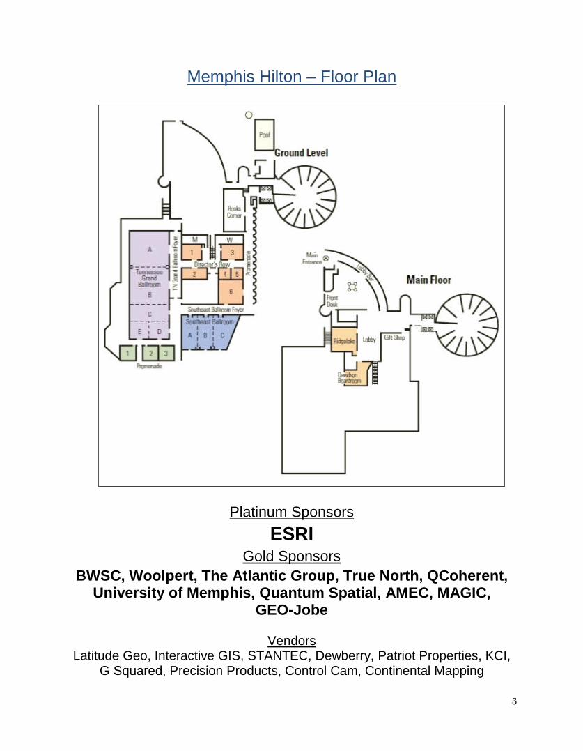
Memphis Hilton – Floor Plan
Platinum Sponsors ESRI
Gold Sponsors BWSC, Woolpert, The Atlantic Group, True North, QCoherent,
University of Memphis, Quantum Spatial, AMEC, MAGIC, GEO-Jobe
Vendors
Latitude Geo, Interactive GIS, STANTEC, Dewberry, Patriot Properties, KCI, G Squared, Precision Products, Control Cam, Continental Mapping

6
2014 TNGIC Platinum & Gold Sponsors
Platinum Sponsor
Gold Sponsors

7
Keynote on Wednesday by Paul Schlatter NOAA National Weather Service
Paul Schlatter is the National Weather Service's (NWS) Acting Deputy Chief of Staff. In this role, he directly supports the director and deputy director of the NWS, and helps develop policies, coordinate internal and external communications, and foster informed decisions towards enabling a Weather-Ready Nation. In 2011 and 2012, he worked in NOAA's Coordination Office (PCO), as the National Weather Service (NWS) liaison for NOAA and NWS leadership. As PCO, he provided senior staff support to NOAA senior leadership. He represented the NWS and works with six other PCO specialists representing the other NOAA Line and Program Offices, to ensure adequate coordination and attempts to resolve differences dealing with programmatic, scientific and management issues within the agency. The PCO advises NOAA senior leadership on broad management initiatives and high priority issues requiring immediate attention, and he staffs NOAA
leadership when they participate in or attend events related to weather. Prior to working in PCO, Paul spent 10 months as an executive adviser to the director of the NWS, advising on severe weather and radar related issues, and providing staff support for many of the Director's meetings and events. From 2003-2011, Paul worked for at the NWS Warning Decision Training Branch (WDTB) in Norman, OK, as a meteorologist instructor. While with WDTB, he designed and delivered a wide range of training modules for the NWS, focusing on high impact weather warnings. He was the project lead for the dual-polarization radar operations course and was instrumental to the success of the development and deployment of the upgrade to the nation’s fleet of 159 radars. He continues to be a subject matter expert with NOAA regarding radar and severe weather warnings, and is often interviewed for live or taped news stories. Paul graduated from Westmont College in Santa
Barbara, CA with a B.S. in Engineering Physics, and received an M.S. in Meteorology. Keynote Topic: The National Weather Service recently upgraded all 159 Doppler Radars with Dual-Polarization (dual-pol) technology. The upgrade to dual-pol is the most significant enhancement made to the nation’s federal weather radar system since Doppler technology was first installed in the early 1990s. Dual-pol radar sends and receives both horizontal and vertical polarized energy, which produces a much more informative picture of the size and shape of the objects in the sky. This provides meteorologists the ability to distinguish between rain, snow, hail and non-weather targets like wildfire smoke plumes, birds and insects. This keynote talk will explain how NWS forecasters use the new data to dramatically improve detection of high impact weather events, and how services to the nation are enhanced.

8
Keynote on Thursday by Kenneth Pelman NOAA National Weather Service
Kenneth Pelman received his B.S. and M.S. in Meteorology from The Pennsylvania State University in 2000 and 2002, respectively. Since then, he has been working at the Climate Prediction Center, an agency within the National Weather Service as a meteorologist and developer. In 2011, he received his M.S. in Geographic Information Systems, also from Penn State. At the Climate Prediction Center (CPC), his duties include forecasting, web development, tool development and maintenance, as well as GIS. Due to increased demand from its customer base, CPC became the first National Center for Environmental Prediction to issue all of its daily forecasts as shapefiles, as well being the first in the National Weather Service to issue a daily forecast using ArcGIS technology end-to-end, including processing a first-guess map to post-processing output files. Since last fall, he has also been co-project manager on a NOAA-wide effort to set up an enterprise geospatial dissemination system. He currently lives with his wife and two sons with a third son expected for early April. Topic: For over 10 years, GIS within the National Weather Service, specifically, and the National Oceanic and Atmospheric Administration (NOAA), in general, has been a grassroots effort with little support from upper management. However, a turning point has occurred, and an exciting effort is currently underway. For the first time, resources have been put towards a NOAA-wide effort to set up an enterprise geospatial system. In this talk, Kenneth Pelman, co-project manager, will discuss the details of this project and how it can positively impact the users of NOAA geospatial data.

9

10
Map Gallery 2014
The 2014 TNGIC Annual GIS Conference Map Gallery! We are excited to announce the Map Gallery for 2014! Look for the Map Gallery to be a separate and distinct area in the Exhibit Hall with plenty of space for you to casually peruse the variety of maps on display. Map Judging and Awards - Our map contest will feature awards for 4 categories. Best Cartographic Design - Awarded to the map that artistically employs the elements of cartography without compromising use and functionality. Maps will be judged on fundamental cartographic principles including figure ground representations, visual hierarchy, color selection, typography, symbology, overall aesthetic appearance, etc. Best Analysis - Awarded to the map that is best designed to display the results of spatial data analysis and presents the information in an unbiased way, allowing the viewer to extract their own conclusions, utilizing the map as a tool. Best Student Project – Awarded to the best overall student project. Submitted maps may be cartographic or analytically focused. Viewer’s Choice – Award chosen by the attendees for the best overall poster. Rules and Regulations
• General poster size should be no larger than E-sized (34 in X 44 in). • A .pdf of your map (96 dpi) must be submitted via e-mail to the map gallery coordinator
([email protected]) by April 11, 2014 to be considered for judging and awards. • MAPS RECEIVED AFTER APRIL 11, 2014 WILL NOT BE ELIGIBLE FOR JUDGING AND
ONLY BE ELIGIBLE FOR THE VIEWERS CHOICE AWARD.

11

12
Dr. Shop / Vendor Tool Time
On Wednesday and Thursday TNGIC will host a Dr. Shop / Vendor Tool time in the Directors Row Room #5 allowing opportunities for conference exhibitors and sponsors to showcase their products and services on a more personal basis. Find answers to your GIS questions through hands-on assistance at the Dr. Shop. Stop by the vendor booths to schedule a time to learn more about their services and products. Check the schedule for list of vendor showcase times. There are four time periods where it will be open to all Conference Attendees:
Wednesday, April 23rd 1:30 pm – 2:30 pm Wednesday, April 23rd 3:00 pm – 4:30 pm Thursday, April 24th 8:00 am – 9:00am Thursday, April 24th 12:30 pm – 1:30 pm
13
14
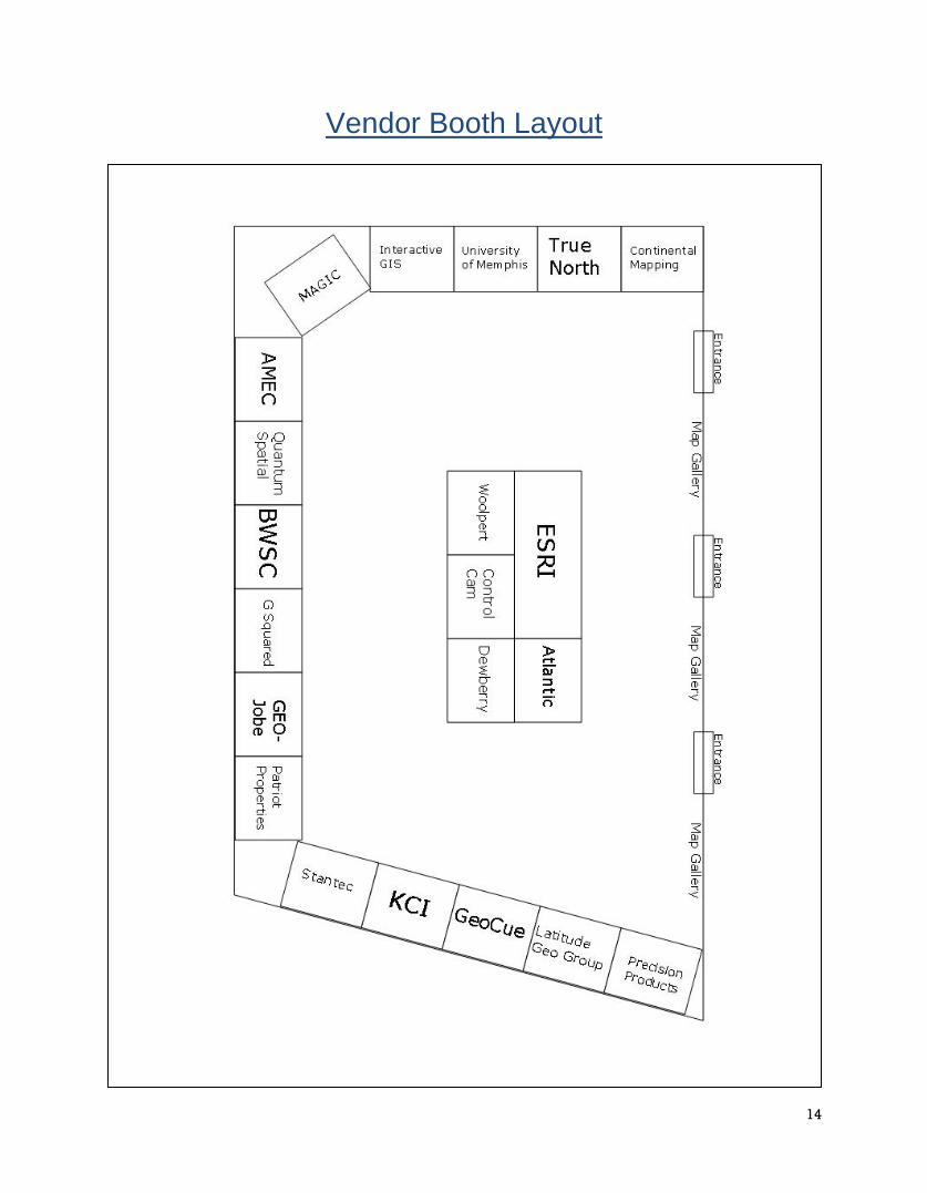
Vendor Booth Layout
15
TNGIC Committees
Thursday 11:00-11:15am
TNGIC Committees will meet for 15 minutes to discuss plans for the upcoming year and to organize members who would like to help on a committee. These committees are the back-bone of TNGIC and are responsible for all TNGIC activities including training classes and workshops, the annual conference, maintaining the TNGIC website, and producing the quarterly newsletter. The Conference Planning Committee organizes, plans, and facilitates the TNGIC Annual GIS Conference. This committee handles all of the details and decisions that are required to make this a successful event for TNGIC members. Tennessee Grand Ballroom CDE The goal of the Education & Outreach Committee is to foster educational opportunities and promote awareness of TNGIC throughout the geospatial community. These opportunities include creating training classes and workshops, supporting TNGIC regional meetings, student outreach, and GIS day activities. Tennessee Grand Ballroom CDE The Communication Committee produces the quarterly newsletter “TNGIC Today” and strives to improve the communication throughout TNGIC. Tennessee Grand Ballroom CDE The goal of the Web & Data Committee is to encourage and facilitate data sharing and distribution throughout the geospatial community; and to increase the connectivity of TNGIC members through a web presence and social media. This committee is responsible for creating and distributing information that includes, but not limited to lists of GIS related groups and sites, GIS job postings, and the web site content, promotion and maintenance. Tennessee Grand Ballroom CDE The goal of the relatively new Finance Committee is to provide input to the Board of Directors concerning opportunities for improving the financial health of the organization. The vision for the committee would be to research and offer the Board of Directors grant opportunities and/or fund raising opportunities throughout each conference year for the Board’s consideration. Tennessee Grand Ballroom CDE If you have ideas for how to make any of these better for the TNGIC members, then join the committee and let your voice and ideas be heard. If you would like more from your TNGIC membership, consider joining one of them to make this a better organization for all of its members. The more we contribute, the better our organization will be for all of its members.
16
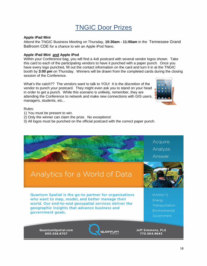
TNGIC Door Prizes Apple iPad Mini Attend the TNGIC Business Meeting on Thursday, 10:30am - 11:00am in the Tennessee Grand Ballroom CDE for a chance to win an Apple iPod Nano. Apple iPad Mini and Apple iPod Within your Conference bag, you will find a 4x6 postcard with several vendor logos shown. Take this card to each of the participating vendors to have it punched with a paper punch. Once you have every logo punched, fill out the contact information on the card and turn it in at the TNGIC booth by 3:00 pm on Thursday. Winners will be drawn from the completed cards during the closing session of the Conference. What’s the catch?? The vendors want to talk to YOU! It is the discretion of the vendor to punch your postcard. They might even ask you to stand on your head in order to get a punch. While this scenario is unlikely, remember, they are attending the Conference to network and make new connections with GIS users, managers, students, etc... Rules: 1) You must be present to win. 2) Only the winner can claim the prize. No exceptions! 3) All logos must be punched on the official postcard with the correct paper punch.
17

18
2014 TNGIC Board of Director Nominees The TNGIC Board of Directors is the governing body of TNGIC and is elected by the general membership at the annual conference. Newly elected Board of Directors will serve a term of 3 years. Please vote for three of the following nominees and turn in your ballots by 3:30 pm on Wednesday.
Justin Graham Justin Graham is a native Nashvillian and graduate from the University of Tennessee. After a year internship
at TVA working for the Natural Heritage program, he began a GIS career with AMEC Environment & Infrastructure in Nashville working for federal, state, and local governments. His positions spanned GIS Specialist, Project Manager, and Business Developer for ten and a half years. In November of 2013 he started the Information Management Practice at Barge Waggoner Sumner & Cannon from their headquarters in Nashville. In this role, he is expanding the use of Application Development, Asset Management, GIS, Mobile Apps, Remote Sensing, and Technology Consulting in support of engineering services.
Justin has been heavily involved in TNGIC over the past 4 years. He served a 1 year term on the Board of Directors in 2010 then was re-elected for a 3 year term in 2011. During that time he served as Vice President (2011), President (2012), and is currently fulfilling the duties of Past-President. If elected, Justin will continue to contribute to the advancement of the use of spatial technology in Tennessee.
Kurt Snider Kurt Snider is a cartographer with the U.S. Fish and Wildlife Service in Cookeville, Tennessee. He has been
with the Service for 20 years and spent the first 7 years of his career at the National Wetlands Inventory in St. Petersburg, Florida, mapping the wetlands of the United States.
Kurt has been a TNGIC member for 14 years and has served on the Board of Directors and as President from 2009-2010. He worked on the development of the first website for TNGIC as well as the Tennessee Spatial Data Server. Kurt also helped develop and teach the Experience GIS in Tennessee training course and has also taught cartographic design at several TNGIC conferences. He has served on the conference planning committee and organized the map gallery and poster competition for the last 7
years.
Kurt has a graduate degree in geography from the University of South Florida, has been married for 29 years and has 4 children. His interests outside of GIS include playing the drums and coaching lacrosse.

19
Kimberley L. Denney Kim Denney began her career as an Account Manager for Atlantic, a company specializing in remote sensing,
surveying and consulting services located in Huntsville, Alabama. After three years, she was promoted to Associate Vice President and is the lead representative for the firm’s government and private sector activity throughout the State of Tennessee. Kim has been a TNGIC member since 2011, actively involved on the conference planning committees as well as serving as Secretary of the TNGIC Board of Directors in 2012. Since 2011, she has attended nearly every TNGIC regional forum as well as every Annual Conference as a dedicated sponsor on behalf of her company. Kim’s combined experience has provided her with the ability to become a vocal advocate for TNGIC initiatives, working to educate and connect GIS professionals throughout the State as a whole.
Her passion for the GIS industry continues to grow each day; thus, giving her the energy and drive to take on the responsibilities of a TNGIC Board Member in order to achieve the organization’s missions and goals. If
elected, Kim would like to help TNGIC increase the organization’s statewide outreach in order to not only enhance TNGIC’s presence and membership status, but to also provide more opportunities for GIS professionals to come together as one through educational events.
Kim graduated from the University of Alabama with a specialization in International Business Management and a minor in Spanish.
Bill Avant Bill Avant is the GIS lead for Tennessee State Parks under the Tennessee Department of Environment and
Conservation. From 1992 to 1998, he worked as an instructor for the North Carolina Outward Bound School in the Pisgah National Forest and the Everglades National Park.
In 2001, Bill received his Masters of Science degree in Natural Resource Management from North Carolina State University. In collaboration with the United State Forest Service in the Caney Creek Wilderness, his work included sociological and biological studies, trail impact assessment, and plant species identification and preservation.
In October 2002, Bill started working for the State of TN as a Conservation Planner and then as GIS Manager in 2004. He has served on the National Recreation and Parks Associations GIS technical advisory committee and has served on the TNGIC Board for the last 3 years. He currently serves on the TN
Geographic Names Committee, and has facilitated numerous workshops in GPS and GIS. In 2008 Bill added the responsibility of managing TDEC’s Real Property.
Bill has overseen the design of the tngic.org website and also recently completed a redesign of the tngis.org website. Bill maintains the TNGIC Twitter and Facebook accounts and works hard to maintain member communications with all electronic media. One of those uses of new technology for TNGIC is the Guidebook, an online Conference program guide.
20
Rick Stieg Effective February 1st, 2006 Richard Stieg has been appointed by Shelby County Mayor AC Wharton as the
Geographic Information Systems (GIS) Coordinator serving the Regional GIS Board, a policy making group of both public and private sector interests involved in the development of computerized mapping technologies.
Mr. Stieg was formerly Director of Planning for the City of Bartlett and was instrumental in the development of a municipal application of GIS for land use and transportation planning, park and fire station siting, and assisting the city’s emergency management personnel in addressing and boundary identification.
It was this background in addressing and associated issues that led to Mr. Stieg being appointed to Mayor Wharton’s Blue Ribbon Panel investigating 911 emergency dispatch issues. Mr. Stieg served as co-chair (along with Wink Downen of the Shelby County Sheriff’s Office) of
the communications and inter-operability subcommittee.
Mr. Stieg has 25 years’ experience with geographic information system technology, serving on the Board of Directors of the Tennessee Geographic Information Council (also past president of that statewide organization) and the Memphis Area Geographic Information Council, and is or has been a member of the National States Geographic Information Council, the Geospatial Information Technology Association, the Association of American Geographers, and the American Planning Association. Mr. Stieg received certification from the GISCI in November, 2012.
21
Socialize and get to know each other at the Great Hall
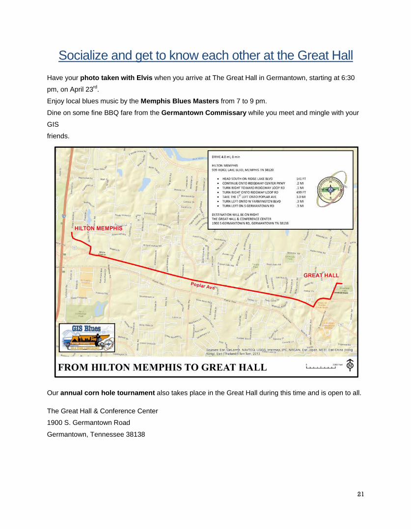
Have your photo taken with Elvis when you arrive at The Great Hall in Germantown, starting at 6:30
pm, on April 23rd.
Enjoy local blues music by the Memphis Blues Masters from 7 to 9 pm.
Dine on some fine BBQ fare from the Germantown Commissary while you meet and mingle with your
GIS
friends.
Our annual corn hole tournament also takes place in the Great Hall during this time and is open to all.
The Great Hall & Conference Center
1900 S. Germantown Road
Germantown, Tennessee 38138

22
TNGIC Booth
Here’s a list of the items you need to drop off at the TNGIC booth!
• TNGIC Board of Directors Ballot – deadline is 3:30 pm on Wednesday!
• Viewer’s Choice Map Gallery Ballot – deadline is 3:30 pm on Wednesday!
• Exhibitor Punch Card for iPad Mini and iPod Giveaway – deadline is 3:00
pm on Thursday!
• Conference Evaluation – deadline is 3:00 pm on Thursday!

23
2014 TNGIC Conference Planning Committee The Conference Planning Committee is made up of individuals from Federal, State, and local governments and private industries across Tennessee who volunteer their time and effort to make this a successful event. Without the hard work of all of these individuals this conference would not have been possible. Please join me and extend a very warm “thank you” to each of them! Sincerely, Gayle Moore 2014 Annual Conference Chair Justin Abart Justin Graham Marc Pearson Shawn Anderson Jeanette Jones Joyce Pierson Bill Avant David Ladd Tim Prather Kurt Butefish David Light Teresa Prince Greg Butler Kim McDonough Greg Rhinehart Kim Denney Dave McMillen Kurt Snider Jason Duke Sam Moffat Rick Steig Susan Finger Gayle Moore Suzanne White
True North Geographic Technologies
provides software applications,
consulting, development, and support
services to public and private sector
organizations interested in
implementing the ESRI platform for
their geographic information system (GIS) needs. True North clients include State and Local
Governments, Utilities, Healthcare, 9-1-1, Emergency Management and Law Enforcement agencies.
Our in-depth domain expertise in these industries, coupled with our extensive knowledge of Esri
software, provides customers with quick return on their investment. True North Geographic
Technologies is an Esri Gold partner and designated as an Esri ArcGIS Online and ArcGIS for Local
Government Specialty partner. True North’s commitment to our customers and our proven success
with ESRI-based award winning solutions highlights our position as a preeminent Esri integrator.
Visit our website to learn more about our pre-packaged solutions and services offerings.
www.tngeo.com
24
Presentation Abstracts
Wednesday 11:00 – 11:30 Statewide GIS Coordination Update and Recent Activities Dennis Pedersen, State of Tennessee OIR Services Abstract OIR GIS Services is continuing its mission to develop framework GIS data layers for Tennessee. Following on the direction laid out in the Enhanced Elevation business plan, the focus now is expanding our LiDAR data collection efforts. The presentation will demonstrate the LiDAR data products in VanBuren and Sequatchie counties and discuss the current efforts in Scott Co. In addition, the presentation will also discuss the efforts of OIR GIS Services and the “Next Generation 911 Project”. Wednesday 1:30 New Traffic Sign Maintenance Requirements using GIS Dwayne Coley, [email protected] DR1 Abstract We have collected over 4500 points for signs. This presentation will talk about setting up and using the GeoXT Timble unit to collect the data and transfer data to ArcGIS 10.1 using GPS Pathfinder. Starting from a blank map and adding the collected data. Next going to ArcCatalog and adding layers to the map. In the Layer Properties (Symbology) adding valves, size, colors, etc. Working in table of Contents organizing layers. Using the Identify tool and going into attributes showing how to use the data. Starting an Editor Sessions and updating the data and saving. Geomentoring and TNGIC Outreach Opportunities Tim Prather, [email protected] DR2 Abstract Two of the earliest goals of TNGIC are “create a cohesive GIS community,” and “promote professional development.” You can help accomplish these goals through GeoMentoring – "adopting" a school, class, or club and supporting educators working with youth. You can help beginning GIS users appreciate the importance of geography and some of the career opportunities for GIS users. And, you can help them avoid a lot of frustrations by sharing your geospatial knowledge and experiences. Join in a discussion of GeoMentoring activities and opportunities for TNGIC to expand our individual and collective outreach, and celebrate some successful GeoMentoring outcomes by TNGIC GeoMentors. Efficiently deploying web-based GIS Solutions for Public Safety Craig Robinson, [email protected] DR3 Abstract When a crisis strikes, public safety agencies require data and information that can help expedite decision making. Data visualization and map-centric applications have greatly improved the capabilities of public safety agencies to plan for and respond to events. But how do we efficiently deploy GIS applications that are intuitive and powerful and available across many computing platforms? In this session we will explore a platform approach to building and deploying web-based GIS applications with workflows and reports that can be delivered via a browser to workstations, laptops, tablets and Smartphones in both connected and disconnected (from the Internet) modes. This will include a live demonstration of web-based GIS applications for policing and damage assessment that leverage HTML5 technology. Automated QC of LiDAR Elevation Data Mark Meade, [email protected] DR6 Abstract FOCUS is a software tool that produces a clear definition of the quality of LiDAR deliverables. FOCUS includes 43 individual tests of the LiDAR dataset. The tools within FOCUS are reducing the cost of LiDAR processing, and
25
substantially reducing problems in the delivered data. Wednesday 2:00 Blount County's Street Sign Journey Ray Boswell, [email protected] DR1 Abstract One of the first things that I learned with GIS is that there is more than one way to get from point A to point B. With that in mind, this presentation will document our experience working with the Blount County Highway department on their street sign inventory. Specifically, we will discuss the methodology employed for the initial data collection efforts, and the solution that was implemented for ongoing maintenance and for visual sign retro-reflectivity inspections. Server 2008 R2 inspection database that gives users the ability to ascertain the quality of grease related treatment in food service establishments. TNGIC Has a Horse in this Race: Geography Education in Tennessee Kurt Butefish, [email protected] DR2 Abstract Much has occurred over the past year concerning K-12 geography education in Tennessee…some of it good, but most of it bad. Because the students impacted by these changes will, hopefully, one-day become GIS users, your employees, and/or decision makers, TNGIC and its members need to be aware of and proactive towards these changes. Come hear about efforts spearheaded by the Tennessee Geographic Alliance to influence the rapidly changing geography curriculum in Tennessee, including a new Introduction to Geographic Information Systems course that will be introduced through high school Career and Technical Education departments beginning in the 2014-15 school year. Reality of Recreational Grade GPS Accuracy Sandy Melhorn, [email protected] DR3 Abstract In today's world, there are many manufacturers of recreational grade GPS units. These manufacturers make promises about the accuracy of their units. In a yearlong study, the effects of various factors on 4 models of recreational grade GPS units were examined. At four specified locations, survey grade GPS equipment was used to determine the true coordinates. This study was done to record and analyze the effects of various weather conditions, seasonal conditions, and various tree cover conditions on the GPS units' accuracies. Durability and usability were not the focus of this study but they were included since it is a very important factor relating to the usefulness and longevity of the units themselves. What can you do with 10 billion points? Kayla Barnowsky, [email protected] DR6 Abstract What can you do with LIDAR data? This is a question that is asked by many in the GIS industry. LIDAR data can be used in various ways, adding a different kind of element to your GIS workflow. In this presentation, we will explore some common ways to derive significant value from LIDAR data sets within the ArcGIS environment, including visualization of the point cloud, land uses, and hydrological purposes. I will use a combination of Power Points and the ArcGIS LIDAR software extension - LP360 to demonstrate these topics of discussion. The overall aim is to provide GIS users, who have access to LIDAR, with ideas that can allow them to unlock hidden value in these often underused data sets. Wednesday 3:00 Clearing the FOG: An HTML5 application for tracking Fats, Oils, & Grease inspections in Food Service Establishments Amanda O'Shea, [email protected] DR1 Abstract The City of Baltimore is developing a comprehensive Fats, Oil, & Grease (FOG) Program as required by the EPA Consent Decree to minimize grease-related blockages in the sewer system. A key component of the program is implementing a comprehensive inspection system for Food Service Establishments (FSE) that discharge FOG-laden wastewater. These FSEs are required to have and maintain grease traps or interceptors (Grease Control Devices - GCD) as well as a

26
wastewater discharge permit. KCI developed an inspection application using ArcGIS Server to enable rapid inspection and reporting on the quality of treatment of FOG-laden wastewater. A web based mobile reporting tool was put in place utilizing the inspection data for easy review of historical inspection data. The web reporting tool provides a live connection to the SQL Server 2008 R2 inspection database that gives users the ability to ascertain the quality of grease related treatment in food service establishments.
Introduction to ArcGIS Online (3:00 – 4:30 Tim Prather, [email protected] DR2 Abstract An introduction to ArcGIS Online as a tool for creating and sharing maps and teaching basic geospatial concepts. Crowd-Sourcing the Nation Bill Sneed, [email protected] DR3 Abstract The U.S. Geological Survey’s web-based volunteered geographic information portal, The National Map Corps, made its public debut in April 2013 and represents a long evolution of volunteer engagement that started with annotating topographic lithographs in 1994. Volunteers use a simple web site to edit existing man-made structures data and add new features that are on the landscape but not in the USGS databases. Quality assessment has been very promising; the volunteer’s actions have been accurate and exceed USGS quality standards. With the expansion from a single state investigation to its current nation-wide presence, The National Map Corps is poised to make a significant contribution to The National Map, including the US Topo. Fusing Geospatial Data Jeremy Mullins, [email protected] DR6 Abstract GRW will provide a discussion on the benefits of fusing Geospatial Data (including Airborne and Terrestrial LiDAR, Aerial Photography, Planimetric and Topographic Mapping, Orthoimagery, and GIS) to quickly and efficiently produce 3D Data suitable for floodplain mapping, treetscapes, utility inventories, and impervious surfaces. The presentation will include projects recently Wednesday 3:30 Supporting Utility Inspection Workflows with ArcGIS Online Jeremy Weber, [email protected] DR1 Abstract As with all utilities, a central part of Gibson County Utility District’s (GCUD) operations is erforming routine inspections on their various gas distribution network assets. These inspections ensure system integrity and are a critical part of the overall distribution integrity management program (DIMP). This presentation will demonstrate how GCUD is using ArcGIS Online to modernize their inspection workflows. Transforming a paper-based system to digital and providing real-time data to decision makers. Lessons learned and challenges will be discussed. Technology covered will be ArcGIS Online, Collector for ArcGIS and Operations Dashboard for ArcGIS. Innovative TMDL Data Management & Planning Strategies Dustin Henry, [email protected] DR3 Abstract Many local and state jurisdictions are experiencing similar challenges associated with the organization of a multitude of non-standardized storm water and TMDL datasets as well as rigorous requirements for reporting compliance within a compressed timeframe for implementation. Our presentation will highlight several key TMDL data modeling best practices as well as a practical approach for leveraging spatial information. We will explore project planning and site selection methodologies utilizing GIS tools and operations, while also providing insight into the challenges and opportunities associated with TMDL data management, reporting, and compliance. This presentation will highlight best practices and strategies applied by KCI Technologies for various clients focusing on streamlining TMDL data management, enhancing project planning activities, and standardizing compliance reports. This presentation is
27
applicable to state and local stakeholders responsible for TMDL compliance. Objectives : -Demonstrate how GIS is leveraged through the TMDL / NPDES tracking and reporting process. -Identify the process of compiling various source data into a centralized dataset. -Identify applications/tools for viewing and editing data. Fusing Mobile and Airborne LiDAR, Aerial Imagery and Ground Survey To Support the Design and Construction of Complex Transportation Projects Dana M. Sommer, [email protected] DR6 Abstract Highway transportation infrastructures, in urban environments, are regularly studied for maintenance and design improvements to support growth. Design projects are exacerbated in urban environments due to complex existing infrastructure, traffic, regulatory limitations and compressed timelines. The collection and assimilation of highly accurate and current geospatial data is critical for the design and construction of such projects. In addition, the fusion of geospatial data from airborne and terrestrial LiDAR, aerial imagery and land survey data provide organizations a breadth of tools to overcome the challenges of urban environments. Although the value of data fusion is evident, the planning and logistics of data fusion projects are also more complicated. For example, traditional geospatial projects would require only one set of reference control for use with an airborne digital sensor. Today, it is not unusual to deploy a second or third set of reference control surveys for use with both airborne and terrestrial sensor references to a single project area of interest. This presentation will highlight several urban transportation projects undertaken by the Tennessee Department of Transportation. Particular emphasis will be on best practices for the planning and logistics of projects such as this. Attendees will leave with an awareness of best practices used in the planning and execution of complex urban. Wednesday 4:00 Tipton County Has Never Looked So Good: Pictometry Online Shawn Anderson, [email protected] DR1 Abstract The presentation will provide an overview of the new Tipton County Pictometry Online program and how it’s used within TCGIS and Local Government. Characterizing Stream Buffer Condition in GIS for the Neuse River Regional Watershed Plan Scott Gregory, [email protected] DR3 Abstract The Neuse River Basin drains a land area of over 6,200 square miles from the central piedmont of North Carolina to the Pamlico Sound located off the coast. The basin includes the Raleigh-Durham-Cary area (the Triangle). Rapid population growth and widespread development create a significant need for stream/wetland mitigation projects in this basin. Future completion of the I-540 loop is a major driver for mitigation credits with possible routes of the proposed interstate potentially impacting streams, wetlands, and habitat. Tactical GIS in the Emergency Environment Jamison Peevyhouse, [email protected] DR6 Abstract This course will present ways that GIS is being used in the tactical environment. Participants will learn about “Situational Intelligence” and how GIS plays a vital role in high priority situations. Participants will also see how GIS derivatives from LiDAR to Google Street View are assisting in the search, apprehension and trials of major offenders. Lastly, the presenters will give a real-world scenario depicting how GIS + Situational Intelligence can turn disaster level events into manageable operations.
28
Presentation Abstracts
Thursday 8:00 The Advantages of ArcGIS for Dyslexic People Nicholas Glover, [email protected] DR1 Abstract Dyslexia is a disorder that many people know of, but don't truly understand what it is. Many know it as a problem with reading, but it goes much further than just that. In this lecture we will go over many of the difficulties that I have had being a dyslexic person in a world where everything is written, and how ArcGIS is one of the few things that I have been able to grasp. I will go over the reasons why ArcGIS is well suited for people who may have reading disabilities and what we could do to improve our teaching methods of ArcGIS for people who have learning disabilities. Urbanization and Climate Change in Tennessee Jason Duke, [email protected] and Matt Snider, [email protected] DR3 Abstract Urbanization proves to be an ongoing issue in the world of wildlife conservation. Pristine habitat of endangered species are at risk as a result of this phenomenon. SLEUTH Urbanization data and land use data were used to analyze land use categories most likely to become urbanized from 2010 to 2100 for Tennessee. Forest and Pasture/Hay land use categories exhibit the most change to urban over the 90 year span. As a result, conservationists are able to locate areas that are in need of protection. Plant hardiness is a crucial measure when looking at climate change. Hardiness zones display where certain plants can survive year round. Analysis was done comparing the zones from 1990 to the ones of 2012. A major shift in the hardiness zones were apparent according to the analysis that was completed. A few unexpected shifts in some areas were also discovered. Plant hardiness zones help gardeners and farmers know what plant and crops will be supported in what parts of the State based on climate data averaged over a certain amount of time. Assessing Urban Tree Canopy in the Midsouth using Multispectral Imagery and LiDAR Eric Goddard, [email protected] DR6 Abstract Urban Forests provide many environmental, economic, and cultural benefits to residents. The University of Memphis' Center for Partnerships in GIS and the Wolf River Conservancy are working with the Tennessee Department of Agriculture's Division of Forestry to conduct an urban tree canopy assessment for Shelby County and two Tipton County communities. Multi-spectral NAIP imagery and high-resolution LiDAR were used to develop a five-class land cover assessment and tree canopy height and extent layers. These layers were used to develop land cover and canopy metrics for all Shelby County municipalities, two Tipton County municipalities and the Memphis city council districts. Priority planting areas were then identified, accounting for environmental and socioeconomic factors. The project results will be discussed, including a review of the software used and processing techniques. Thursday 8:30 Metadata Blues Wade Bishop, [email protected] DR1 Abstract This paper presents the Geographic Information Librarianship project funded by the Institute of Museum and Library Services (IMLS). The recent and rapid progression of technology has forced librarians and archivists to both face changes in the format and types of information objects they work with, as well as the related legacy issues of past platforms to collect, view, and create geographic information for GIS users. A great need to preserve, curate, and make findable geospatial data results from advances in open source GIS software, the GeoWeb, volunteered geographic information (VGI), and the expansion of both public and private sector data sharing projects. The paper will discuss metadata schema, issues in information management, as well as include an open discussion about the metadata blues and potential partnerships with archives and libraries.
29
Bringing “Place” into Public Health: The Role of GIS Jason Hodges, [email protected] DR3 Abstract To better understand how different areas of the county may have diverse health problems, the Shelby County Health Department has incorporated GIS analysis of key social determinants of health, risk factors and disease outcomes for certain conditions at the zip-code level. Examining sub-county level data and generating maps to show the geographic distribution of risk factors and health outcomes may assist in targeting resources and developing health policies and interventions that are tailored to specific communities. This presentation will focus on sharing maps about infant mortality, chronic diseases, food deserts and the underlying social determinants of health to illustrate practical applications of GIS analysis in real-world public health practice. Additionally, this presentation will discuss the discipline-specific challenges and as well as lessons learned from employing GIS methods in examining the landscape of community health. With a Little Help from Our Friends: Achieving HERE Map Freshness Dave Merrick, [email protected] DR6 Abstract The movie Field of Dreams made famous the quote “If you build it, he will come.” Commercial map company HERE Maps (formerly known as NAVTEQ) followed this advice and built a digital map in every country in the world. And people came: the HERE Map is accessed over 100 million times per day. Unfortunately, the voice from Field of Dreams never provided an answer to the question “If you build it, how do you maintain and improve it?” Dave Merrick from HERE’s Nashville office discusses HERE’s approach to maintaining their map in an ever-changing world and the key role local governments and community mappers play in keeping the map fresh. Thursday 2:00 Cloud Based Tool for Orthoimagery QA/QC Jeffrey Simmons, [email protected] DR1 Abstract VOICE (Virtual On-line Inspection, Checking, and Editing) is a cloud based quality assessment and data-dissemination too designed to allow stakeholders the ability to review imagery simultaneously and record issues, correction or edits in a central repository. VOICE users can submit, edit, review and update calls on the imagery. The submitted calls are passed to the vendor for review and correction. Additional functionality of VOICE includes an overview map, map navigation, and a dynamic legend. The user also has the ability to download, draw, measure, bookmark, print, or export maps, use search function, and export documents and reports. VOICE has been a significant effort for several years and continues to grow and evolve. It not only gives the client the ability to VOICE their feedback, which gives them a higher satisfaction in their product, but also provides the consultant with an organized and efficient workflow for centralizing multiple stakeholder feedback. GIS, Your Flux Capacitor for Reservoir Storage Modeling Greg Rhinehart, [email protected] DR3 Abstract One dimensional numerical models are used to examine hydraulics of rivers, channels, and floodplains. While conveyance of a system is often the focus when defining model parameters, storage is another major component that influences the behavior of the model in a reservoir system. Storage areas exist where the velocity of water is effectively zero relative to the downstream direction. Areas such as bays, inlets, coves, and small tributaries contribute to the total storage of the reservoir and are integral to routing the hydrograph volume through the system. This presentation outlines an approach that utilizes GIS to determine total reservoir storage. Key components to the approach include TIN creation, modified projections, 3D Analyst, and Model Builder. As part of the process, the tools were subject to validation procedures that involved designing and testing the process in an alternative software package, our alternative software package was AutoCAD Civil 3D.
30
Tracking Parcel Value Through Time Nate Ron-Ferguson, [email protected] DR6 Abstract Analyzing how the value of property has changed from year to year is often complicated by the dynamic nature of property exchanges as parcel boundaries are frequently modified through splits, consolidations, and reevaluations. To assist the Mayor's Innovation Delivery Team (MIDT} , a government non-profit partnership established through the Bloomberg Philanthropies , the Center for Partnerships in GIS at the University of Memphis is developing an application to evaluate and compare changes in parcel geometry in order to identify the amount of change in property value at the parcel level. The application uses a variety of GIS Python packages to identify, reallocate, and convert property values , taking into account the dollar value for the year in which the comparison is being made. This presentation will discuss the process, challenges, and outcomes that were encountered during the development of this project as well as lessons learned and future improvements. Thursday 2:30 Influence of site and labor attributes on the location of economic activities: Case of the Memphis metropolitan area Angela Antipova, [email protected] DR1 Abstract Employment landscape is highly uneven across the urban space. The US metropolitan areas experience a decentralization trend with many businesses re-locating to new suburban locations closer to worker residencies and suburban amenities. Within the post-industrial economy, what are the most important factors in employment location decision? The influence of the site attributes upon employment location was examined in the medium-sized Memphis metropolitan area, Tennessee. Additionally, the degree of importance of labor force attributes such as gender, race, earning, and age for the location of economic activities was analyzed. The findings suggest that within polycentric urban structure the proximity to both central location (the CBD) and to the largest employment concentration impact the job location in general. Another site-specific characteristic, a type of a road, influences the location of economic activities, with the access to major roads appearing to be of greatest importance. Disconnected Data Collection Jason Knisley, [email protected] DR3 Abstract The Center for Partnerships in GIS (CPGIS), along with the Ground Water Institute, Powers-Hill Design, and CDM Smith, recently conducted a Visual Steams Assessment for Shelby County Public Works. Rather than sending fields crews out with paper forms, a camera, and a standalone GPS, CPGIS developed a custom data collection application using ESRI’s ArcGIS Runtime SDK for Android. This allowed field crews to perform disconnected editing, utilizing electronic forms setup to improve QAQC on the front end. Cached imagery allowed for better spatial awareness, the tablet’s GPS allowed for accurate location of features, and the tablet’s camera allowed photos of impairments to be automatically attached to features at the time of collection. Topics covered will include high level design decisions made during the creation of the application as well as lessons learned during the process of using the application in the field. Transitioning to an Enterprise GIS Kevin Bingham, [email protected] DR6 Abstract In the spring of 2013 Collierville GIS staff proposed major changes related to the Town's use of GIS technology. The proposal included significantly increasing our GIS licensing costs, offering external mapping applications for our citizens, and developing internal mapping applications for Town staff. The Town hired a consultant to perform an evaluation of our existing GIS implementation and provide recommendations for improvements. These recommendations were used to formulate a plan to increase the use of GIS Technology throughout our organization and the community. During this presentation we will discuss how Collierville GIS was able to implement many of those changes, the state of Collierville GIS today, and the work that is left to do.

31
_________________________________________________________________________________
_________________________________________________________________________________
_________________________________________________________________________________
_________________________________________________________________________________
________________________________________________________________________________
_________________________________________________________________________________
_________________________________________________________________________________
_________________________________________________________________________________
_________________________________________________________________________________
_________________________________________________________________________________
_________________________________________________________________________________
_________________________________________________________________________________
_________________________________________________________________________________
_________________________________________________________________________________
_________________________________________________________________________________
_________________________________________________________________________________
_________________________________________________________________________________
_________________________________________________________________________________
_________________________________________________________________________________
_________________________________________________________________________________
_________________________________________________________________________________
_________________________________________________________________________________
_________________________________________________________________________________
_________________________________________________________________________________
32
TNGIC Contact Information TNGIC P.O. Box 330906 Nashville, TN 37203 [email protected] TNGIC Home Page: http://www.tngic.org Tennessee Spatial Data Server: http://www.tngis.org 2013-2014 Board of Directors President Suzanne White, GISP, State of Tennessee Past President Justin Graham, GISP, AMEC Vice-President Jason Duke, U.S. Fish and Wildlife Service Secretary Tim Prather, UT-Knoxville Treasurer Sam Moffat, Woolpert
Justin Abart, AutoZone Bill Avant, State of Tennessee David Ladd, USGS David McMillen, NRCS Kurt Butefish, UT-Knoxville Marc Pearson, Stantec Greg Butler, Hixson Utility
***Special thanks to the Board Members who terms are expiring this year and have given to TNGIC their time and talent. THANK YOU!!! Bill Avant David Ladd Justin Graham
Thank you to our supporting Vendors, We hope you had a chance to visit with them at their booths!


