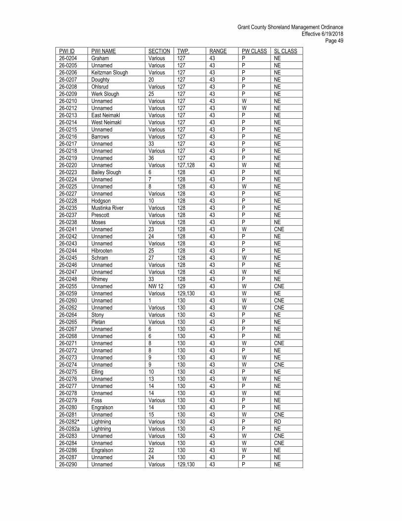
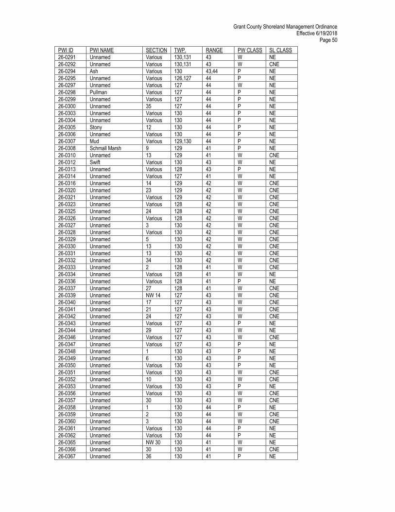
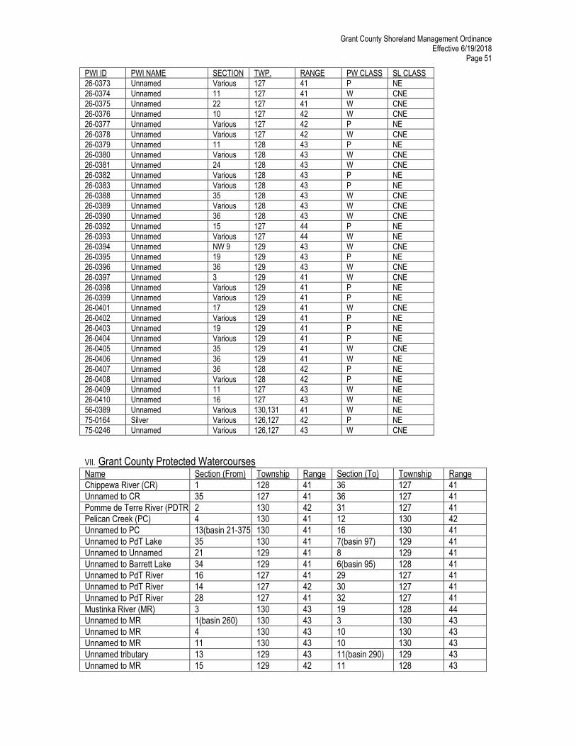
Grant County Shoreland Management Ordinance Effective 6/19/2018 Page 1 Table of Contents Shoreland Management Ordinance of Grant County Page I. General Provisions 3 A. Title 3 B. Purpose 3 C. Policy 3 D. Statutory Authorization 3 E. Legal Authority/Jurisdiction 3 F. Compliance 3 G. Enforcement 3 H. Interpretation 4 I. Savings Clause/Severability 4 J. Abrogation and Greater Restrictions 4 K. Owner Liable 4 II. Definitions 4 III. Classification System 13 A. Natural Environment Lakes 14 B. Recreational Development Lakes 14 C. General Development Lakes 14 D. Agricultural Rivers 14 E. Public Waters 14 F. Classifications 15 IV. District Requirements 15 A. District Boundaries 15 B. Sensitive Areas 15 C. Shoreland Classifications and Uses; lakes 16 D. Shoreland Classifications and Uses; Rivers 17 E. Lot Area, Suitable Area and Setback Requirements 18 V. General Requirements 20 A. Water Supply 20 B. Sewage Treatment and Waste Disposal 20 C. Shoreland Alterations 20 D. Agricultural Use Standards 22 E. Forest Management Standards 23 F. Extractive Use Standards 24 G. Standards for Commercial, Industrial, Public & Semi-Public Uses 24 H. Storm Water Management 24 I. Maintenance of Storm Sewers, Ag Drain Tile & Ditch Outlets 25 J. Installation of Ag Drain Tile Outlets or Drainage Ditches 25 K. Repair of Public Drainage Systems 25 L. Subdivision Provisions 26
Transcript
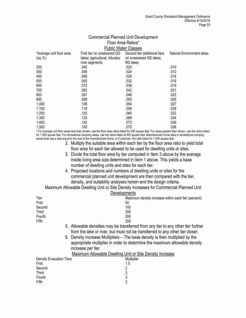
Grant County Shoreland Management Ordinance Effective 6/19/2018
Page 1
Table of Contents Shoreland Management Ordinance of Grant County
Page I. General Provisions 3 A. Title 3 B. Purpose 3 C. Policy 3 D. Statutory Authorization 3 E. Legal Authority/Jurisdiction 3 F. Compliance 3 G. Enforcement 3 H. Interpretation 4 I. Savings Clause/Severability 4 J. Abrogation and Greater Restrictions 4 K. Owner Liable 4 II. Definitions 4 III. Classification System 13 A. Natural Environment Lakes 14 B. Recreational Development Lakes 14 C. General Development Lakes 14 D. Agricultural Rivers 14 E. Public Waters 14 F. Classifications 15 IV. District Requirements 15 A. District Boundaries 15 B. Sensitive Areas 15 C. Shoreland Classifications and Uses; lakes 16 D. Shoreland Classifications and Uses; Rivers 17 E. Lot Area, Suitable Area and Setback Requirements 18 V. General Requirements 20 A. Water Supply 20 B. Sewage Treatment and Waste Disposal 20 C. Shoreland Alterations 20 D. Agricultural Use Standards 22 E. Forest Management Standards 23 F. Extractive Use Standards 24 G. Standards for Commercial, Industrial, Public & Semi-Public Uses 24 H. Storm Water Management 24 I. Maintenance of Storm Sewers, Ag Drain Tile & Ditch Outlets 25 J. Installation of Ag Drain Tile Outlets or Drainage Ditches 25 K. Repair of Public Drainage Systems 25 L. Subdivision Provisions 26
Grant County Shoreland Management Ordinance Effective 6/19/2018
Page 2
M. Subdivision Exceptions 29 N. Planned Unit Developments 30 O. Public Streets & Roads 35 P. Controlled Access 36 Q. Duplex, Triplex & Quad Standards 38 R. Buffer Compliance 38 S. Non-Conforming Uses 38 T. Exemptions 39 VI. Administration 40 A. Site Permits 40 B. Administrative Officer 41 C. Conditional Use Permits 41 D. Board of Adjustment 42 E. Variance from Standards 43 F. Amendments 44 G. Enforcement and Penalties 44 H. Effective Date 44 I. Validity 44 J. Notification Procedures 45 VII. Grant County Protected Waters & Shoreland Classification Lake List 46
Grant County Shoreland Management Ordinance Effective 6/19/2018
Page 3
The County Board of Commissioners of Grant County, Minnesota ordains: I. General Provisions A. Title This ordinance from the date of its passage shall be known as the Shoreland Management Ordinance of Grant County, Minnesota. B. Purpose The purpose of the ordinance is to regulate the use and orderly development of shorelands in Grant County, to prevent and eliminate pollution of public waters and to maintain historic values of significant historic sites in the unincorporated areas of Grant County, and to preserve and enhance our natural resources as provided in the Environmental Rights Act, Minnesota Statutes 116B. C. Policy The uncontrolled use of shorelands of Grant County, Minnesota affects the public health, safety, and general welfare not only by contributing to pollution of public waters, but also by impairing the local tax base. Therefore, it is the best interests of public health, safety, and welfare to provide for the wise subdivision, use, and development of shorelands of public waters. The Legislature of Minnesota has delegated responsibility to local governments of the state to regulate the subdivision, use, and development of the shorelands of public waters and thus preserve and enhance the quality of surface waters, conserve the economic and natural environmental values of shorelands, and provide for the wise use of waters and related land resources. This responsibility is hereby recognized by Grant County. D. Statutory Authorization
This shoreland ordinance is adopted pursuant to the authorization and policies contained in Minnesota Statutes, Chapter 105, Minnesota Regulations, Parts 6120.2500-6120.3900, Minnesota Statutes, section 103F.48, and the planning and zoning enabling legislation in Minnesota Statutes Chapter 394 (for counties) or Chapter 462 (for municipalities).
E. Legal Authority/Jurisdiction The provisions of this ordinance shall apply to the shorelands of the public water bodies as classified in Section IV of this ordinance. Pursuant to Minnesota Regulations, Parts 6120.2500- 6120.3900, no lake, pond, or flowage less than 10 acres in size in municipalities or less than 25 acres in size in unincorporated areas need be regulated in a local government’s shoreland regulations. A body of water created by a private user where there was no previous shoreland shall not be exempt from this ordinance. The jurisdiction of this shoreland ordinance is the unincorporated areas of Grant County lying outside the incorporated areas of a city. F. Compliance The use of any shoreland of public waters; the size and shape of lots; the use, size, type, and location of structures on lots; the installation and maintenance of water supply and waste treatment systems; the grading and filling of any shoreland area; the cutting of shoreland vegetation; and the subdivision of land shall be in full compliance with the terms of this ordinance and other applicable regulations. G. Enforcement The Administrative Officer is responsible for the administration and enforcement of this ordinance. Any violation of the provisions of this ordinance or failure to comply with any of its requirements (including violations of conditions and conditional uses) shall constitute a misdemeanor and shall be punishable as defined by law. Violations of this ordinance can occur regardless of whether or not a permit is required for regulated activity pursuant to the Section of Administration of this ordinance.
Grant County Shoreland Management Ordinance Effective 6/19/2018
Page 4
H. Interpretation In their interpretation and application, the provisions of the ordinance shall be held to be the minimum requirements and shall be liberally construed in favor of the governing body and shall not be deemed a limitation or repeal of any other powers granted by State Statutes. I. Savings Clause/Severability All permits issued under this ordinance are permissive only and shall not release the permittee from any liability or obligation imposed by Minnesota Statutes, Federal Law, or local ordinances relating thereto. In the event any section, clause, portion or provision of this ordinance shall be found contrary to law by a court of competent jurisdiction from whose final judgment no appeal has been taken, such provision shall be considered void. All other provisions of this ordinance shall continue in full force and effect as though the voided provision had never existed. J. Abrogation and Greater Restrictions It is not intended by this ordinance to repeal, abrogate, or impair any existing easements, covenants, or deed restrictions. However, where this ordinance imposes greater restrictions, the provisions of this ordinance shall prevail. All other ordinances inconsistent with this ordinance are hereby repealed to the extent of the inconsistency only. K. Owner Liable In addition to any other person or persons involved in a violation or threatened violation of this ordinance, the owner of record of any property falling under the jurisdiction of this ordinance shall be responsible both criminally and civilly for any construction, alteration, excavation, or any other activity occurring upon his property which is contrary to the provisions of this ordinance. II. Definitions A. For the purpose of this ordinance, certain terms and words are herein defined as follows: 1. Words used in present tense shall include the future; and words used in singular number shall include the plural number and the plural and singular. 2. The word “shall” is mandatory and not permissive. 3. The word “may” is permissive. 4. All distances, unless otherwise specified, shall be measured horizontally. 5. Accessory Structure (including water-oriented) or facility: “Accessory structure” (including water-oriented) or facility means a small, above ground building or other improvements, except stairways, fences, docks, and retaining walls, because of their relationship of its use to a surface water feature, reasonably needs to be located closer to public waters than the normal structure setbacks. They shall include, but not be limited to, boat houses, fish houses, gazebos, screen houses, pump houses, detached decks, fish cleaning houses and storage buildings (less than 150 sq. ft. except boat houses may be up to 250 sq. ft.) 6. Access Lot. “Access lots” is a parcel of land that provides access to public waters. 7. Administrative Officer: The administrator of the Office of Land Management and/or his/her designees. 8. Agriculture: The use of land for agricultural purposes, including farming, dairying, pasturage, agriculture, horticulture, floriculture, viticulture, and animal and poultry husbandry and the necessary accessory use for packing, treating, or storing the produce; provided,
Grant County Shoreland Management Ordinance Effective 6/19/2018
Page 5
however, that the operation of any such accessory uses shall be secondary to that of the normal agricultural activities. 9. Agricultural Structure: Any structure existing or erected and used principally for agriculture purposes, with the exception of dwelling units. 10. Animal Feedlot: A lot or building or combination of lots and buildings intended for the confined feeding, breeding, raising or holding of animals and specifically designed as a confinement area in which manure may accumulate or where the concentration of animals is such that a vegetative cover cannot be maintained within the enclosure. For purposes of these parts, open lots used for the feeding and rearing of poultry (poultry ranges) shall be considered to be animal feedlots. Pastures shall not be considered animal feedlots under these parts. 11. Apartment Building: A dwelling structure on a single lot or parcel, having five units or more respectively, being attached by common walls and each unit equipped with separate sleeping, cooking, eating, living and sanitation facilities. These units would be rental units. 12. Attached Structure: Two buildings are attached when they share a common wall or portion of a wall with a door, so that a person may travel from any portion of one building to any portion of the second building without going outside. 13. Bed & Breakfast: An owner-occupied single-family residence at which lodging and meals are provided to registered guests. The Bed & Breakfast facility shall comply with all the applicable State and Local regulations for providing food and lodging. 14. Bluff: “Bluff” means a topographic feature such as a hill, cliff, or embankment having all of the following characteristics; a. Part or all of the feature is located in a shoreland area. b. The slope rises at least 25 feet above the ordinary high water level of the water body. c. The grade of the slope from the toe of the bluff to a point 25 feet or more above the ordinary high water level averages 30% or greater. d. The slope must drain toward the water body. An area with an average slope of less than 18% over a distance for 50 feet or more shall not be considered part of the bluff. 15. Bluff Impact Zone (BIZ): A bluff and the land located within 30 feet from the top of a bluff. 16. Boathouse: A structure designed and used solely for the storage of boats or boating equipment. The maximum size of a boathouse cannot exceed 250 square feet. 17. Buildable Area: The minimum required area remaining on a newly created parcel of land or platted lot after all public ROW, easements, setbacks, bluffs, wetlands and other sensitive areas have been excluded. 18. Building: Any fixed construction with walls and/or a roof.
Grant County Shoreland Management Ordinance Effective 6/19/2018
Page 6
19.Buffer: As defined in Minn. Stat.§103.F.48, subd.1(c) and includes all lands located parallel to and 50 feet from the ordinary highwater mark, if identified, or the top or crown of the bank or normal water level as provided in Minnesota Statutes, section 103F.48, subd. 3(c), whichever is applicable. 20.Buffer protection map.
Has the meaning provided in Minn. Stat.§103.F.48, subd.1(d) and which is available on the Grant County, MN website.
21. Building Line: Building line is a line parallel to a lot line or the Ordinary High Water Mark at the setback beyond which a structure may not extend. 22. Campground. “Campground” means a development that is used for the purpose of providing sites for non- permanent overnight use by campers using tents, trailers, recreation camping vehicles, or other temporary shelters. 23. Central Sewage System: A system of treating sewage from multiple sources which shall be approved by the Minnesota Pollution Control Agency. 24.Certificate of survey.
“Certificate of survey” is a graphic representation of the boundary survey of a parcel of real property along with the description of the land and the signed certification of a Minnesota licensed land surveyor.
25. Clustering or clustered. “Clustering” or “clustered” means a development pattern and technique whereby structures or building sites are arranged in close proximity to one another in non-linear groups, adjacent to permanently preserved common open space, so as to make efficient and visually aesthetic use of the natural features of the landscape and maximize visualization of permanently preserved open space.
26. Commercial Planned Unit Developments: “Commercial Planned Unit Developments” are typically uses that provide transient, short- term lodging spaces, rooms, or parcels and their operations are essentially service- oriented. For example, hotel/motel accommodations, resorts, recreational vehicle and camping parks, and other primarily service-oriented activities are commercial planned unit developments. 27. Commercial Use: The principal use of land or building for the sale, lease, rental, or trade of products, goods, or services. 28. Commissioner: Commissioner means the commissioner of the Department of Natural Resources. 29. Conditional Use: A land use or development as defined by ordinance that would not be appropriate generally, but may be allowed with appropriate restrictions as provided by official controls upon a finding that: a. Certain conditions as detailed in the zoning ordinance exist. b. The use or development conforms to the comprehensive land use plan of the county. c. Is compatible with the existing neighborhood.
Grant County Shoreland Management Ordinance Effective 6/19/2018
Page 7
30. Conditional Use Permit: A permit for the grading/filling of soil within shoreland as set forth in this ordinance or any activity as defined by “Conditional Use”. 31. Condominium: A dwelling structure on a single lot or parcel, having two or more units respectively, being attached by common walls and each unit equipped with separate sleeping, cooking, eating, living and sanitation facilities. These units would be owner occupied. 32. Conservation subdivision.
“Conservation subdivision” is a method of subdivision characterized by common open space and clustered compact lots, with the purpose of creating greater community value through open space amenities for homeowners and protection of natural resources, while allowing for the residential densities consistent with prevailing densities. Site designs incorporate standards of low impact development, such as the use of some single-load roadways and narrower rights-of-way, looped road-ways versus cul-de-sacs, maximum road setbacks for structures, and preservation of trees, shoreline, unique resources, and scenic vistas, and these developments use stormwater designs that emphasize on-site retention and infiltration through the preservation of native vegetation within the shore impact zone, use of pervious surfaces, rain gardens, and swales.
33. Controlled Access: Any private site, field or tract of land abutting a classified body of water to be used primarily for access purposes. Including, but not limited to back-lot access. 34. Conventional subdivision.
“Conventional subdivision” means a pattern of subdivision development that permits the division of land in the standard form where lots are spread evenly throughout a parcel with little regard for natural features or common open space as compared to a conservation subdivision where lots are clustered and common open space is provided.
35. Cooperative. "Cooperative" means a common interest community in which the real estate is owned by an association, each of whose members are entitled by virtue of the member's ownership interest in the association to a proprietary lease.
36. Deck: A horizontal, unenclosed platform with or without attached railings, seats, trellises, or other features attached or functionally related to a principal use or site and at any point extending (more than 12”) above ground. SEE PATIO. 37. Detached Deck: A deck or porch that is not physically attached to a building and is at least ten (10) feet from that building. 38. Development.
“Development” is typically a piece of property that is divided into subdivisions with residential houses constructed on each piece of subdivided land.
39. Dock: A platform extending water-ward from the shoreline intended for ingress and egress for moored watercraft or to provide access to the deeper water for swimming, fishing, or other water oriented recreational activity. 40. Duplex, Triplex, Quad: “Duplex”, “triplex”, or “quad” means a dwelling structure on a single lot, having two, three, or four units respectively, being attached by common walls and each unit equipped with
Grant County Shoreland Management Ordinance Effective 6/19/2018
Page 8
separate sleeping, cooking, eating, living, and sanitation facilities. These may be owner occupied and/or rented. 41. Dwelling Site: A designated location for residential use by one or more persons using temporary or moveable shelter, including camping and recreational vehicle sites. 42. Dwelling Unit: Any structure or portion of a structure, or other shelter designed as short or long term living quarters for one or more persons, including rental or timeshare accommodations such as motel, hotel, or resort rooms or cabins. 43. Environmental Assessment Worksheet (EAW): A brief document, in worksheet format, that helps local governments and state agencies decide whether a proposed action is a major action with the potential for significant environmental effects and in case of a private action, whether it is of more than local significance. If the action meets these criteria, an environmental impact statement (EIS) should be prepared. 44. Environmental Impact Statement (EIS): An informational document which contains a thorough evaluation of the environmental effects of a proposed project. The EIS provides information for agencies and private persons which helps them not only to evaluate the impacts of proposed actions which have the potential for significant environmental effects, but to consider alternative to institute methods for reducing adverse environmental effects. 45. Erosion Potential.
“Erosion potential” is the degree to which the soil surface can be eroded away by wind, overland flow of snowmelt, rain, or flood waters.
46. Excavation: Any act by which organic matter, earth, sand, gravel, rock, or any other similar material is dug up, quarried, removed or bulldozed. 47. Extractive Use: The use of land for surface or subsurface removal of sand, gravel, rock, industrial minerals, other nonmetallic minerals, and peat not regulated under Minnesota Statutes, Section 93.44 to 93.51. 48. Fee Schedule: A document setting forth fees for subdivisions, permits, applications, and appeals. The Board of County Commissioners establishes these fees at a meeting in January of each year. The County Fee Schedule is on file in the Office of Land Management. 49. Filtering Basin: A wetland, low area or basin that may contain related vegetation which functions to remove sediment, organic matter, and other pollutants from runoff or wastewater by filtration, deposition, infiltration, absorption, adsorption, decomposition and volatilization, thereby reducing pollution and protecting the environment. 50. Forest: A plant community in which the dominant vegetation is trees and other woody vegetation. 51. Forest Land Conversion: The clear cutting of forest lands to prepare for a new land use other than reestablishment of a subsequent forest stand.
Grant County Shoreland Management Ordinance Effective 6/19/2018
Page 9
52. Garage: A structure designed and used for the storage of automobiles, motor vehicles and related equipment. 53. Garage Quarters An area of a garage containing a bathroom and/or single bedroom used and intended for short term human occupancy 54. Grade & Fill Permit: A permit for the grading and filling of soil in the shore impact zone of up to ten (10) cubic yards and up to three hundred (300) cubic yards outside the shore impact zone as set forth in this ordinance. 55. Grading & Filling: Any change of the natural topography of land, except for normal agricultural purposes. 56. Guest Cottage/Guest House/ Bunkhouse: A structure used as a dwelling unit that may contain sleeping spaces and kitchen and bathroom facilities in addition to those provided in the primary dwelling unit on a lot. 57. Hardship: The property in question cannot be put to a reasonable use if used under the conditions allowed by the official controls; the plight of the landowner is due to circumstances unique to the property not created by the landowner; and the variance, if granted, will not alter the essential character of the locality. Economic considerations alone shall not constitute a hardship if a reasonable use for the property exists under the terms of the ordinance and as defined in Minnesota Statutes Chapter 394. 58. Height of Building: The vertical distance between the highest adjoining ground level of the building or ten (10) feet above the lowest ground level, whichever is lower, and the highest point of a flat roof or average of the highest gable of a pitched or hipped roof. 59. Ice Ridge:
A modification to the topographic characteristics of the shore resulting from a water basin expanding and contracting ice sheets and consisting of a linear mound of soil that is above the ordinary high water mark and is created in the current year. It is generally parallel to the water’s edge. 60. Impervious Surface: Any surface that is incapable of being penetrated by water and thereby restricts percolation into the ground including but not limited to the “footprint” of a structure or building, a deck, a driveway, a patio, or a sidewalk. 61. Improved Lot: A lot that contains a single-family dwelling, ready for immediate use, that is served by a sewage treatment system and water supply, all of which comply with all state and local regulations. 62. Industrial: Any activity engaged in, but not limited to, the cleaning, servicing, testing, repairing, storage, processing, construction, manufacturing, or fabrication of goods or products. 63. Intensive Vegetation Clearing: The complete removal of trees or shrubs in a contiguous patch, strip, row, or block. 64. Lot (including standard and substandard): A parcel of land designed by plat, metes and bounds, registered land survey, auditor’s plat, or other accepted means and separated from parcels or portions by said description
Grant County Shoreland Management Ordinance Effective 6/19/2018
Page 10
for the purpose of development, sale, lease, or separation. (Standard lot is equal to or greater than the minimum requirements set by this ordinance.) See IV. District Requirements 1. Minimum Shoreland Ordinance Standards for lakes and rivers. 65. Lot Width: Lot width is the shortest distance between lot lines measured at the midpoint of the building line. 66. Manufactured Home: A manufactured relocatable single family dwelling unit greater than forty (40) body feet in length, eight and a half (81/2) feet in width, or when onsite more than 399 square feet and which is built on a permanent chassis and designed to be used as a dwelling with or without a permanent foundation. This includes park models that meet this definition. 67. Manufactured Home Park: Shall mean any area whether charging a fee or free of charge on privately or publicly owned land used on a daily, nightly, weekly, or longer basis for the accommodation of two or more manufactured homes or recreation units. 68. Nonconformity:
Any legal use, structure or parcel, of land established before the effective date of this ordinance, which does not conform to use restrictions of a particular zoning district. This provision does not apply to the buffer compliance requirements of this ordinance. Section V.D. This also should not be confused with sub-standard dimensions of a conforming use.
69.Normal water level The level evidenced by the long-term presence of surface water as indicated directly by hydrophytic plants or hydric soils or indirectly determined via hydrological models or analysis
70. Open Space: Any space or area preserved in its natural state and specifically not used for parking, building, or roads. 71. Ordinary High Water Mark (OHWM): The boundary of public waters and wetlands and shall be an elevation delineating the highest water level which has been maintained for a sufficient period of time to leave evidence upon the landscape, commonly that point where the natural vegetation changes from predominantly aquatic to predominantly terrestrial. For watercourses, the ordinary high water mark is the elevation of the top of the bank of the channel. For reservoirs and flowages, the ordinary high water mark is the operating elevation of the normal summer pool, also known as High Water Level. 72. Patio: A horizontal unenclosed platform without railings, seats, trellises, or other features attached or functionally related to a principal use or site and any point not extending above ground level. 73. Performance Bond: A bond which may be required by the County Board, Planning Commission or Board of Adjustment to insure the completion of any activity falling under the jurisdiction of this ordinance. 74. Planning Unit Development: A type of development characterized by a unified site design for a number of dwelling units or dwelling sites on a parcel, whether for sale, rent, or lease, and also usually involving clustering of these units or sites to provide areas of common open space, density increases, and a mix of condominiums, time-share condominiums, cooperatives,
Grant County Shoreland Management Ordinance Effective 6/19/2018
Page 11
full fee ownership, commercial units, residential condominiums, townhouses, apartment buildings, recreational camping areas, manufactured home parks, resorts, hotels, motels, and conversions of structures and land uses to these uses. 75. Public Waters: Any waters as defined in Minnesota Statutes, Section 103G.005, Subdivisions 15 and 18. However, no lake, pond, or flowage of less than ten (10) acres in size in municipalities and twenty-five (25) acres in size in unincorporated areas need be regulated for the purposes of Minnesota Rules 6120.2500 to 6120.3900. A body of water created by a private user, where there was no previous shoreland, shall not be exempt from this ordinance. 76. Recreational Camping Area: Any area, whether privately or publicly owned, used on a daily, nightly, weekly, or longer basis for the accommodation of two or more recreational camping units. 77. Recreational Camping Unit: A relocatable single family dwelling unit 40 feet or less in length, including, but not limited to, tents, motor homes, and travel trailers. 78. Residential Planned Unit Development: A use where the nature of residency is non-transient and the major or primary focus of the development is not service-oriented. This may not be limited to residential apartments, townhouses, condominiums, manufactured home parks, cooperatives and full fee ownership residences would be considered as residential planned unit developments. 79. Riparian Buffer Strip: A fifty (50) foot linear band of undisturbed permanent vegetation adjacent to and parallel to the shoreline intended to maintain or improve water quality by trapping and removing various non-point source pollutants from both overland and shallow subsurface flow. 80. Roof Over-Hang: An unsupported roof extension (eave or soffit) beyond the wall of the building or structure measured horizontally. It cannot be greater than three (3) feet if the wall supporting it is at the minimum setback allowed. 81. Screen Porch: A structure attached to the primary dwelling unit, where at least 80% of the walls consist of screens and/or glass (combination windows). 82. Semi-Public Use: The use of land by a private, nonprofit organization to provide a public service that is ordinarily open to some persons outside the regular constituency of the organization. 83. Sensitive Area: Areas unsuitable for development, or certain types of land use due to wet soils, steep slopes, flooding, inadequate drainage, erosion potential, presence of or discovery of significant historic sites and/or archaeological sites, burial grounds, presence of threatened or endangered plant or animal species, in-water physical and environmental characteristics, values and constraints, or any other feature likely to be harmful to the health, safety, or welfare of the residents of Grant County. 84. Sensitive Resource Management: The preservation and management of areas unsuitable for development in their natural state due to constraints such as shallow soils over groundwater or bedrock, highly
Grant County Shoreland Management Ordinance Effective 6/19/2018
Page 12
erosive or expansive soils, steep slopes, susceptibility to flooding or occurrence of plants or animals in need of special protection. 85. Setback: The minimum horizontal distance between a structure, sewage treatment system, or other facility and an ordinary high water level, top of a bluff, road, highway, property line or other facility. 86. Sewer System: The same as defined in Minnesota Pollution Agency’s Individual Sewage Treatment Systems Standards, Chapter 7080. 87. Shore Impact Zone: Land located between the ordinary high water mark of public water and a line parallel to it at a setback of 50% of the structure setback. 88. Shoreland: Land located within the following distances from public waters: 1,000 feet from the ordinary high water mark of a lake, pond, or flowage; 300 feet from a river or stream or the landward extent of a floodplain designed by ordinance on a river or stream, whichever is greater. The limits of shorelands may be reduced whenever the waters involved are bound by topographic divides which extend landward from the waters for lesser distance and when approved by the Commissioner. 89. Significant Historic Site: Any archaeological site, standing structure, or other property that meets the criteria for eligibility to the National Register of Historic Places or is listed in the State Register of Historic Sites, or is determined to be an unplatted cemetery that falls under the provisions of Minnesota Statutes, Section 307.08. A historic site meets these criteria if it is presently listed on either register or if it is determined to meet the qualifications for listing after review by the Minnesota State Archaeologist or the Director of Minnesota Historical Society. All unplatted cemeteries are automatically considered to be significant historic sites. 90. Single Family Residence: A dwelling unit used by members of one immediate family, including normal appurtenances such as a garage. 91. Site Permit: A permit for the erection and/or alteration of any structure controlled by this ordinance issued to insure compliance with all requirements of this ordinance. 92. Steep Slope: Land where agricultural activity or development is either not recommended or described as poorly suited due to slope steepness and the site’s soil characteristics, as mapped and described in available county soil surveys or other technical reports, unless appropriate design and construction techniques and farming practices are used in accordance with the provisions of this ordinance. Where specific information is not available, steep slopes are lands having average slopes over twelve (12) percent, as measured over horizontal distances of fifty (50) feet or more, that are not bluffs. 93. Storage Buildings (greater than 150 square feet): Structure designed and used for the storage of non-hazardous material and equipment. 94. String Test: A method of establishing a structure setback line by using the closest adjacent points of existing structures to a proposed structure of like use on two immediately adjacent lots.
Grant County Shoreland Management Ordinance Effective 6/19/2018
Page 13
In the event that there is no structure of like use on one of the immediate adjacent lots, the point of the building line at the nearest lot line setback shall be used. Where structures exist on the adjoining lots on both sides of a proposed building site, structure setbacks may be altered without a variance to conform to the adjoining setbacks from the ordinary high water mark provided the proposed building site is not located in a shore impact zone or in a bluff impact zone. 95. Structure: Any building or appurtenance includes decks, except aerial or underground utility lines, such as sewer, electric, telephone, telegraph, gas lines, towers, poles, and other supporting facilities. 96. Subdivision: Land that is divided for the purpose of sale, rent, or lease, including planned unit development. 97. Surface Water-Oriented Commercial Use: The use of land for commercial purposes, where access to and use of a surface water is an integral part of the normal conductance of business. Marinas, resorts, and restaurants with transient docking facilities are examples of such use. 98. Toe of the Bluff: The lower point of a 50-foot segment, measured horizontally, with an average slope exceeding 18 percent. 99. Top of the Bluff: The higher point of a 50-foot segment, measured horizontally, with an average slope exceeding 18 percent. 100.Variance: A modification or variation of the provisions of this ordinance where it is determined, that, by reason of exceptional circumstances, the strict enforcement of any provision of this ordinance would cause unnecessary hardship, or that the strict conformity with the provisions of this ordinance would be unreasonable, impractical, or not feasible under the circumstances as defined under Minnesota Statutes, Chapter 394. 101.wetland: Land transitional between terrestrial and aquatic systems where the water table is usually at or near the surface or the land is covered by shallow water. For purposes of this definition, wetlands must have the following three attributes: a. Have a predominance of hydric soils; b. Are inundated or saturated by surface or ground water at a frequency and duration sufficient to support a prevalence of hydrophytic vegetation typically adapted for life in saturated soil conditions; and c. Under normal circumstances support a prevalence of such vegetation. III. Classification System Grant County shall classify public waters in accordance with the following criteria: A. size and shape; B. amount and type of development at the time of the original classification; C. road and service center accessibility at the time of the original classification; D. existing natural characteristics of the waters and shorelands; E. state, regional, and local plans and management programs;
Grant County Shoreland Management Ordinance Effective 6/19/2018
Page 14
F. existing land use restrictions; G. presence of significant historic sites; H. amount and type of publicly owned shorelands; I. presence of unique, endangered or protected flora or fauna; and J. existing soil character and geomorphology of the shorelands.
The classes of public waters in Grant County are Natural Environment, Recreational Development, General Development and Agricultural River segments. General descriptions of each class are as follows: A. Natural Environment lakes are generally small, often shallow lakes with limited capacities for assimilating the impacts of development and recreational use. They often have adjacent lands with substantial constraints for development such as high water tables, exposed bedrock, and unsuitable soils. These lakes, particularly in rural areas, usually do not have much existing development or recreational use. B. Recreational Development lakes are generally medium sized lakes of varying depths and shapes with a variety of landform, soil, and groundwater situations on the lands around them. They often are characterized by moderate levels of recreational use and existing development. Development consists of mainly seasonal and year-round residences and recreational-oriented commercial uses. Many of these lakes have capacities for accommodating additional development and use. C. General Development lakes are generally large, deep lakes or lakes of varying sizes and depths with high levels and mixes of existing development. These lakes often are extensively used for recreation and, except for the very large lakes, are heavily developed around the shore. Second and third tiers of development are fairly common. The larger examples in this class can accommodate additional development and use. D. Agricultural River segments are located in well-roaded, intensively cultivated areas of western and southern regions of the state. Cultivated crops are the predominant land use, with some pasture and occasional feedlots, small municipalities, and small-forested areas. Residential development is not common, but some year-around-residential use is occurring within commuting distance of major cities. Some intensive recreation use occurs on these river segments in particular areas, but overall recreational use of these waters and adjacent lands is low. Although potential exists for additional development and recreation, water quality constraints and competing land uses, particularly agriculture, will inhibit expansions. E. Public waters shall be classified by the Commissioner. The Commissioner may, as the need arises, reclassify any public water. Also, any local government may at any time submit a resolution and supporting data requesting a change in any shoreland management classification of waters within its jurisdiction to the Commissioner for consideration. The commissioner may also, upon receipt of a resolution, apply multiple shoreland management classifications on a public water. Where the commissioner has received such a resolution, the following policies and criteria shall be used in approving any request for multiple shoreland management classifications on a single public water.
1. for those lakes with regular natural shoreline configurations, possessing few or no bays, arms, islands, peninsulas or points, no multiple shoreland management classifications shall be applied; 2. for lakes with irregular natural shoreline configurations, possessing two or more bays, arms, islands, peninsulas or points, or lakes that have been artificially segmented by roadways, railways, bridges or levees, the commissioner may assign multiple shoreland
Grant County Shoreland Management Ordinance Effective 6/19/2018
Page 15
management classifications to clearly defined portions of the shoreland area consistent with the classification criteria and procedures set forth in subparts 1 through 3 above; 3. in no case shall the commissioner apply multiple shoreland management classifications on a lake with a total water surface acreage less than or equal to 250 acres, or on a single embayment with a total water surface acreage less than or equal to 5 acres; 4. reservoirs on rivers and streams assigned a shoreland management classification may also be eligible for the application of multiple shoreland management classifications, provided they meet all of the criteria set forth in items 1 through 3 above; 5. where comprehensive lake management plans or local water plans are completed and approved.
F. The classification for each area surrounding each public body of water is hereby established according to the document entitled “Waters of Grant County Classification”, which accompanies and is made a part of this ordinance. Such document shall be duly authenticated by the County and shall be kept and maintained by the Administrative Officer, which copy shall be the final authority on the classification for such body of water. IV. District Requirements A. The boundaries of the Shoreland Management Districts defined in this ordinance are hereby established at 1,000 feet from the ordinary high water mark of a lake, pond, or a flowage and 300 feet from a river or the landward extent of the flood plain on such river, whichever is greater. Where the waters involved are bounded by natural topographic divides which extend landward from the waters for lesser distances, the Planning Commission may interpret the district boundaries. B. Areas within these Shoreland Management Districts which due to steep slopes, bluffs, flooding, erosion, limiting soil conditions, the presence of wetlands or other physical constraints are sensitive to development are hereby designated as Sensitive Areas (SA). Sensitive Areas shall be designated in accordance with Minnesota Rules 6120.3100. The Grant County Board of Commissioners shall make the designation of a Sensitive Area.
Grant County Shoreland Management Ordinance Effective 6/19/2018
Page 16
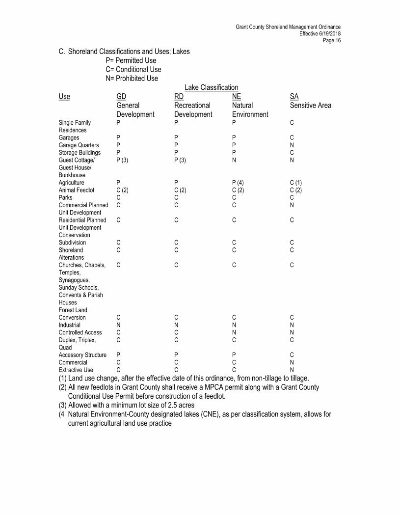
C. Shoreland Classifications and Uses; Lakes P= Permitted Use C= Conditional Use N= Prohibited Use
Lake Classification Use GD
General Development
RD Recreational Development
NE Natural Environment
SA Sensitive Area
Single Family Residences
P P P C
Garages P P P C Garage Quarters P P P N Storage Buildings P P P C Guest Cottage/ Guest House/ Bunkhouse
P (3) P (3) N N
Agriculture P P P (4) C (1) Animal Feedlot C (2) C (2) C (2) C (2) Parks C C C C Commercial Planned Unit Development
Forest Land Conversion C C C C Industrial N N N N Controlled Access C C N N Duplex, Triplex, Quad
C C C C
Accessory Structure P P P C Commercial C C C N Extractive Use C C C N
(1) Land use change, after the effective date of this ordinance, from non-tillage to tillage. (2) All new feedlots in Grant County shall receive a MPCA permit along with a Grant County Conditional Use Permit before construction of a feedlot. (3) Allowed with a minimum lot size of 2.5 acres (4 Natural Environment-County designated lakes (CNE), as per classification system, allows for current agricultural land use practice
Grant County Shoreland Management Ordinance Effective 6/19/2018
Page 17
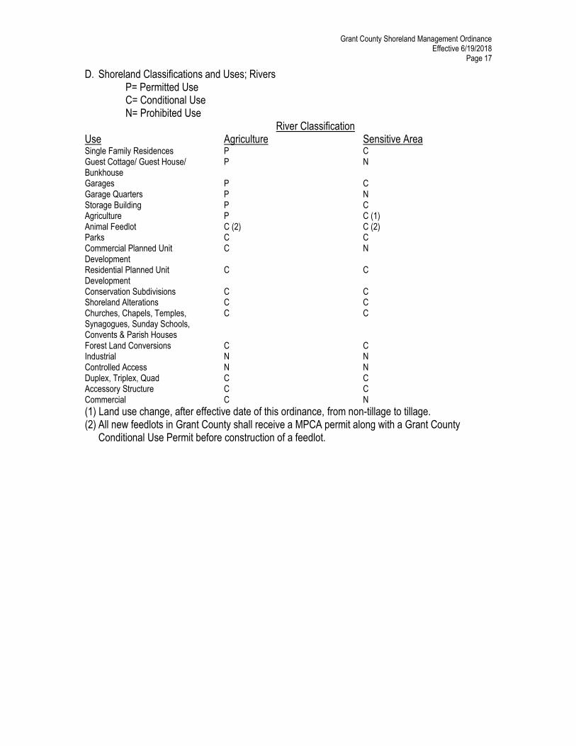
D. Shoreland Classifications and Uses; Rivers P= Permitted Use C= Conditional Use N= Prohibited Use
River Classification Use Agriculture Sensitive Area Single Family Residences P C Guest Cottage/ Guest House/ Bunkhouse
P N
Garages P C Garage Quarters P N Storage Building P C Agriculture P C (1) Animal Feedlot C (2) C (2) Parks C C Commercial Planned Unit Development
C N
Residential Planned Unit Development
C C
Conservation Subdivisions C C Shoreland Alterations C C Churches, Chapels, Temples, Synagogues, Sunday Schools, Convents & Parish Houses
C C
Forest Land Conversions C C Industrial N N Controlled Access N N Duplex, Triplex, Quad C C Accessory Structure C C Commercial C N
(1) Land use change, after effective date of this ordinance, from non-tillage to tillage. (2) All new feedlots in Grant County shall receive a MPCA permit along with a Grant County Conditional Use Permit before construction of a feedlot.
Grant County Shoreland Management Ordinance Effective 6/19/2018
Page 18
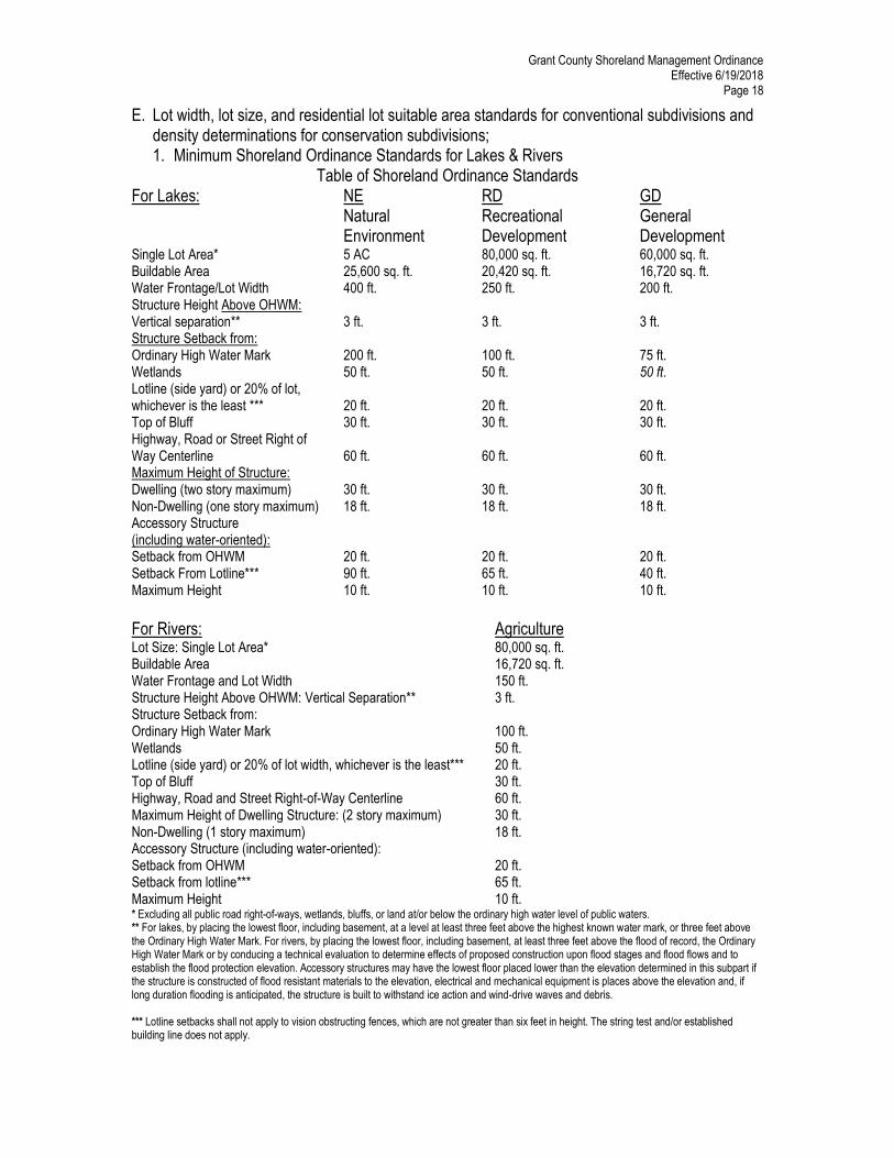
E. Lot width, lot size, and residential lot suitable area standards for conventional subdivisions and density determinations for conservation subdivisions; 1. Minimum Shoreland Ordinance Standards for Lakes & Rivers
Table of Shoreland Ordinance Standards For Lakes: NE
Natural Environment
RD Recreational Development
GD General Development
Single Lot Area* 5 AC 80,000 sq. ft. 60,000 sq. ft. Buildable Area 25,600 sq. ft. 20,420 sq. ft. 16,720 sq. ft. Water Frontage/Lot Width 400 ft. 250 ft. 200 ft. Structure Height Above OHWM: Vertical separation**
3 ft.
3 ft.
3 ft.
Structure Setback from: Ordinary High Water Mark Wetlands
200 ft. 50 ft.
100 ft. 50 ft.
75 ft. 50 ft.
Lotline (side yard) or 20% of lot, whichever is the least ***
20 ft.
20 ft.
20 ft.
Top of Bluff 30 ft. 30 ft. 30 ft. Highway, Road or Street Right of Way Centerline
60 ft.
60 ft.
60 ft.
Maximum Height of Structure: Dwelling (two story maximum)
30 ft.
30 ft.
30 ft.
Non-Dwelling (one story maximum) 18 ft. 18 ft. 18 ft. Accessory Structure (including water-oriented): Setback from OHWM
20 ft.
20 ft.
20 ft.
Setback From Lotline*** 90 ft. 65 ft. 40 ft. Maximum Height 10 ft. 10 ft. 10 ft.
For Rivers: Agriculture Lot Size: Single Lot Area* 80,000 sq. ft. Buildable Area 16,720 sq. ft. Water Frontage and Lot Width 150 ft. Structure Height Above OHWM: Vertical Separation** 3 ft. Structure Setback from: Ordinary High Water Mark Wetlands
100 ft. 50 ft.
Lotline (side yard) or 20% of lot width, whichever is the least*** 20 ft. Top of Bluff 30 ft. Highway, Road and Street Right-of-Way Centerline 60 ft. Maximum Height of Dwelling Structure: (2 story maximum) 30 ft. Non-Dwelling (1 story maximum) 18 ft. Accessory Structure (including water-oriented): Setback from OHWM
20 ft.
Setback from lotline*** 65 ft. Maximum Height 10 ft. * Excluding all public road right-of-ways, wetlands, bluffs, or land at/or below the ordinary high water level of public waters. ** For lakes, by placing the lowest floor, including basement, at a level at least three feet above the highest known water mark, or three feet above the Ordinary High Water Mark. For rivers, by placing the lowest floor, including basement, at least three feet above the flood of record, the Ordinary High Water Mark or by conducing a technical evaluation to determine effects of proposed construction upon flood stages and flood flows and to establish the flood protection elevation. Accessory structures may have the lowest floor placed lower than the elevation determined in this subpart if the structure is constructed of flood resistant materials to the elevation, electrical and mechanical equipment is places above the elevation and, if long duration flooding is anticipated, the structure is built to withstand ice action and wind-drive waves and debris. *** Lotline setbacks shall not apply to vision obstructing fences, which are not greater than six feet in height. The string test and/or established building line does not apply.
Grant County Shoreland Management Ordinance Effective 6/19/2018
Page 19
2. The minimum area and lot width of lots without water frontage (i.e. backlots) must be doubled. 3. Bluff Impact Zone: structures and accessory facilities, except stairways and landings, must not be placed within bluff impact zones. 4. Steep Slopes: Grant County must evaluate possible soil erosion impacts and development visibility from public waters before issuing a permit for construction of sewage treatment systems, roads, driveways, structures, or other improvements on steep slopes. When determined necessary, conditions must be attached to issue permits to prevent erosion and to preserve existing vegetation screening of structures, vehicles and other facilities as viewed from the surface of public waters, assuming summer, leaf- on vegetation. 5. Proximity to unplatted cemeteries and significant historic sites. No structure may be placed closer than fifty (50) feet from the boundary of an unplatted cemetery protected under Minnesota Statutes, Section 307.08, unless necessary approval is obtained from the Minnesota State Archaeologist’s Office. No structure may be placed on a historic site in a manner that affects the values of the site unless adequate information about the site has been removed and documented in a public repository. 6. One accessory structure (including water-oriented) per lot will be allowed, provided: a. The structure must be above ground unless a Conditional Use Permit or a Grade/Fill Permit is granted. b. The structure is ten (10) feet or less in height. c. The structure is 150 square feet or less in size. d. The maximum width of the structure is 20 feet as measured parallel to the shoreline. e. The structure is set back from the Ordinary High Water Mark at least 20 feet. f. The structure must comply with the lot-line setback requirements as set by Sec. IV.E.1. g. The structure must not be used for human habitation or have water or sewer connections. h. The structure is treated to reduce visibility as viewed from public waters and adjacent shorelands by vegetation, topography, increased setbacks, color, or other acceptable means, assuming summer leaf-on conditions. i. The roof of the structure may be used as a deck with safety rails but must not be enclosed or used as a storage area. j. Only one (1) structure is to be located in the Shore Impact Zone. 7. Stairways, lifts, and landings. Stairways and lifts are the preferred alternative to major topographic alterations for achieving access up and down bluffs and steep slopes to shore areas. Stairways and lifts must meet the following design requirements: a. Stairways and lifts must not exceed four (4) feet in width on residential lots, and eight (8) feet in width for commercial properties, public open-space recreational properties and planned unit developments. b. Landings for stairways and lifts on residential lots must not exceed 36 square feet in area. Landings no larger than 64 square feet may be used for commercial properties, public open-space recreational properties and planned unit developments. c. Canopies or roofs are not allowed on stairways, lifts, or landings.
Grant County Shoreland Management Ordinance Effective 6/19/2018
Page 20
d. Stairways, lifts and landings may be either constructed above the ground on posts or pilings, or placed into the ground, provided they are designed and built in a manner that ensures control or soil erosion and authorization by a Conditional Use Permit or Grade/Fill Permit. e. Stairways, lifts and landings must be located in the most visually inconspicuous portions of lots, as viewed from the surface of the public water assuming summer, leaf-on conditions, whenever practical. f. Facilities such as ramps, lifts or mobility paths for physically handicapped persons are also allowed for achieving access to shore areas, provided that the dimensional and performance standards of sub items a to c are complied with, in addition to the requirements of Chapter 1341 of Minnesota Rules. 8. Decks. Except as provided in Items 6 & 7, decks must meet the structure setback standards. Decks that do not meet setback requirements from public waters may be allowed without a variance to be added to structures existing on the date the shoreland structure setbacks were established by Ordinance, if all of the following criteria and standards are met: a. A thorough evaluation of the property and structure reveals no reasonable location for a deck meeting or exceeding the existing Ordinary High Water Mark setback of the structure. b. The deck encroachment toward the Ordinary High Water Mark does not exceed 15 percent of the existing shoreline setback of the structure from the Ordinary High Water Mark or is not closer than thirty (30) feet to the Ordinary High Water Mark, whichever is more restrictive. c. The deck is constructed primarily of wood and is not roofed or screened. 9. Docks. The landward end of all docks must meet the ten (10) feet setback from the nearest lot line unless a written approval is provided by the adjoining landowner.V. General Requirements A. Water Supply 1. Any public or private supply of water for domestic purposes must meet or exceed standards for water quality of the Minnesota Department of Health and the Minnesota Pollution Control Agency. 2. Private wells must be located, constructed, maintained and sealed in accordance with or in a more thorough manner than the Water Well Construction Code of the Minnesota Department of Health. Wells already existing in areas subject to flooding, shall be flood- proofed in accordance with Water Well Construction Code of the Minnesota Department of Health. B. Sewage Treatment and Waste Disposal Any premises used for human occupancy shall be provided with an adequate method of sewage and solid waste disposal. The sanitation standards for this ordinance are set forth in the Sanitation Code of Grant County. C. Shoreland Alterations Vegetative alterations and excavations or grading and filling necessary for the construction of structures and sewage treatment systems under validly issued permits for these facilities are exempt from the vegetative alteration standards in this subpart and separate permit requirements for grading and filling. However, the grading and filling conditions of this subpart must be met for issuance of permits for structures and sewage treatment systems. Alterations of vegetation and topography must be controlled by a
Grant County Shoreland Management Ordinance Effective 6/19/2018
Page 21
Conditional Use Permit or a Grade/Fill Permit to prevent erosion into public waters, fix nutrients, preserve shoreland aesthetics, preserve historic values, prevent back slumping and protect fish and wildlife habitat. Public roads and parking areas are exempt from the provisions of this part. 1. Removal or alterations of vegetation, except for forest management or agricultural uses as provided for is allowed according to the following standards:
a. Intensive vegetation clearing within the buffer area, shore and bluff impact zones and on steep slopes is not allowed. Intensive vegetation clearing outside of these areas is allowed if the activity is consistent with the forest management standards.
b. Limited cutting, pruning, and trimming of trees and shrubs to accommodate the placement of stairways and landings, access paths, as well as providing a view to the water from the principal dwelling site, in shore and bluff impact zones and on steep slopes is allowed, provided that: 1. The screening of structures, vehicles, or other facilities as viewed from the water, assuming summer, leaf-on conditions, is not substantially reduced; 2. Along lakes and rivers, existing shading of water surfaces is preserved; and 3. The above provisions are not applicable to the removal of trees, limbs, or branches that are dead, diseased, or pose safety hazards. 2. Use of fertilizer and pesticides in the shoreland management district must be done in such a way as to minimize runoff into the shore impact zone or public water by use of earth, vegetation or both. 3. No grading, filling, or alteration of existing topography, including retaining walls, shall be performed in the shore or bluff impact zones, on steep slopes, or in a wetland, in excess of one (1) cubic yard of material or elsewhere in the shoreland area in the excess of ten (10) cubic yards per year, unless a Conditional Use Permit or Grade & Fill Permit has been obtained with the following conditions to be met: a. Before authorizing any grading and filling activity in any type 2, 3, 4,5,6,7 and 8 wetland, local officials must consider how extensively the proposed activity would affect the following functional qualities of the wetland. 1. Sediment and pollutant trapping and retention; 2. Storage of surface runoff to prevent or reduce flood damage; 3. Fish and wildlife habitat; 4. Recreational use; 5. Shoreline or bank stabilization; or 6. Noteworthiness, including special qualities such as historic significance, critical habitat for endangered plants and animals or others. b. This evaluation must also include a determination of whether the wetland alteration being proposed requires permits, reviews, or approvals by other local, state, or federal agencies such as Wetlands Conservation Act, watershed district, the Minnesota Department of Natural Resources or the United States Corps of Engineers. 4. Alterations must be designed and conducted in a manner that ensures only the smallest amount of bare ground is exposed for the shortest time possible. 5. Mulches or similar materials must be used, where necessary, for temporary bare soil coverage and a permanent vegetation cover must be established as soon as possible. 6. Methods to minimize soil erosion and to trap sediments before they reach any surface water feature must be used.
Grant County Shoreland Management Ordinance Effective 6/19/2018
Page 22
7. Altered areas must be stabilized to acceptable erosion control standards consistent with the field office technical guides of the Grant Soil and Water Conservation District and the Natural Resources Conservation Service (NRCS). 8. Fill or excavated material must not be placed in a manner that creates an unstable slope. 9. Plans to place fill or excavated material on steep slopes must be reviewed by qualified professionals for continued slope stability and must not create finished slopes of 30 percent or greater. 10. Fill or excavated material must not be placed in bluff impact zones. 11. Any alterations below the ordinary high water mark of public waters must first be authorized by the commissioner. 12. Alterations of topography must only be allowed if they are accessory to permitted or conditional uses and do not adversely affect adjacent or nearby properties. 13. Placement of natural rock riprap, including associated grading of the shoreline and placement of a filter blanket, is permitted if the finished slope does not exceed three feet horizontal to one foot vertical, the landward extent of the riprap is within ten feet of the ordinary high water mark, and the height of the riprap above the ordinary high water mark does not exceed three feet. 14. If more than 10 cubic yards within the Shore Impact Zone is moved a Conditional Use Permit is required. However, if less than 1 cubic yard is moved the size of the equipment within the Shore Impact Zone shall be limited to garden tractor equipment (tiller, disk, drag, etc.). There shall not be any tilled gardening practices within thirty (30) feet of the top of the bluff. 15. The applicant for a Conditional Use Permit or Grade/Fill Permit involving grading and filling or any alteration of the natural topography shall be legally responsible for all storm water sedimentation and pollution entering public waters both during and after the project. 16. All grading and filling or alteration of the natural topography, where seeding is a component of stabilization, shall be performed between April 1st and September 10th. Dormant seeding shall not be allowed. 17. Best Management Practices in Minnesota, and the NRCS/Grant Soil and Water Conservation District Standards shall be followed and a silt fence or other acceptable soil erosion prevention measure is to be used on the lake side of the work being done. The preceding conditions must also be considered during Subdivision, Variance, Site Permits, and other Conditional Use reviews. 18. Connections to public waters - Excavations where the intent purpose is connection to a public water, such as boat slips, canals, lagoons and harbors, must be controlled by local shoreland controls. Permission for excavations may be given only after the commissioner has approved the proposed connection to public waters. D. Agricultural Use Standards 1. The shore impact zone for parcels with permitted agricultural land uses is equal to a line
parallel to and 50 feet from the ordinary highwater mark, if identified, or the top or crown of bank or normal water level as provided in Minnesota Statutes, section 103F.48, subd. 3(c), whichever is applicable. Waters subject to this provision can be found on the Grant County Buffer Protection Map. Provided, however, that those County Natural Environment - CNE Lakes, as per the classification system may continue existing agricultural practices until such time as use of property changes or the property is transferred, at which point the property must conform to the requirements of this ordinance.
Grant County Shoreland Management Ordinance Effective 6/19/2018
Page 23
2. General cultivation farming, grazing, nurseries, horticulture, truck farming, sod farming, and wild crop harvesting are permitted uses if steep slopes and shore and bluff impact zones are maintained in perennial vegetation or operated under an approved conservation plan (Resource Management Systems) approved by the local soil and water conservation district Board of Supervisors that is consistent with the Natural Resources
Conservation Service field office technical guide (FOTG) and the local Soil and Water Conservation District Board of Supervisors policy. 3. Potential Compliance or non-compliance with requirements of this section will be initially determined by the SWCD on a parcel by parcel basis. 4. The Office of Land Management independently will make the final determination of compliance or non-Compliance status for each bank, or edge of a waterbody. 5. The width of any required buffer shall be measured from the ordinary highwater mark, normal water level or the top or crown of the bank, whichever is applicable.
3. Animal feedlots, where allowed by zoning district designations, must be reviewed as a Conditional Use Permit and must meet the following standards: a. New feedlots must not be located in the shoreland of watercourses or in bluff impact zones and must meet a minimum setback of 300 feet from the ordinary high water mark of all public waters basins. b. Modifications or expansions to existing feedlots that are located within 300 feet of the ordinary high water mark or within a bluff impact zone are allowed if they do not further encroach into the existing ordinary high water mark setback or encroach on bluff impact zones. A modification or expansion of an animal feedlot shall require a Conditional Use Permit. c. The appropriate Minnesota Pollution Control Agency permit must be obtained by the owner or operator of an animal feedlot.
4. Use of fertilizer, pesticides, or animal wastes within shorelands must be done in such a way as to minimize impact on the shore impact zone or public water by proper application or use of earth or vegetation. E. Forest Management Standards 1. The harvesting of timber and associated reforestation or conversion of forested use to a non-forested use must be conducted consistent with the following standards: a. Timber harvesting and associated reforestation must be conducted consistent with the provisions of the Minnesota Non-point Source Pollution Assessment-Forestry and the provisions of Water Quality in Forest Management "Best Management Practices in Minnesota." b. Forest land conversion to another use requires issuance of a conditional use permit and adherence to the following standards: 1. Shore and bluff impact zones must not be intensively cleared of vegetation; and 2. An erosion and sediment control plan is developed and approved by the Grant Soil and Water Conservation District before issuance of a conditional use permit for the conversion. 2. Use of fertilizer, pesticides, or animal wastes within shorelands must be done in such a way as to minimize impact on the shore impact zone or public water by proper application or use of earth or vegetation.
Grant County Shoreland Management Ordinance Effective 6/19/2018
Page 24
F. Extractive Use Standards 1. Processing machinery must be located consistent with setback standards for structures from ordinary high water marks of public waters and from bluffs. 2. An extractive use site development and restoration plan must be developed, approved by Grant County, and followed over the course of operation of the site. The plan must address dust, noise, possible pollutant discharges, hours and duration of operation, and anticipated vegetation and topographic alterations. It must also identify actions to be taken during operation to mitigate adverse environmental impacts, particularly erosion, and must clearly explain how the site will be rehabilitated after extractive activities end. G. Standards for Commercial, Industrial, Public and Semipublic Uses 1. Surface water-oriented commercial uses and industrial, public, or semipublic uses with similar needs to have access to and use of public waters may be located on parcels or lots with frontage on public waters. Uses without water-oriented needs must be located on lots or parcels without public waters frontage, or, if located on lots or parcels the public waters frontage, must either be set back double the normal ordinary high water mark setback or be substantially screened from view from the water by vegetation or topography, assuming summer, leaf-on conditions. Those with water-oriented needs must meet the following standards: a. In addition to meeting impervious coverage limits, setbacks, and other zoning standards presented elsewhere in Minnesota Rules Part 6120.2500 to 6120.3900, the uses must be designed to incorporate topographic and vegetative screening of parking areas and structures. b. Uses that require short-term watercraft mooring for patrons must centralize these facilities and design them to avoid obstructions of navigation and to be the minimum size necessary to meet the need. c. Uses that depend on patrons arriving by watercraft may use signs and lighting to convey needed information to the public, subject to the following general standards: 1. No advertising signs or supporting facilities for signs may be placed in or upon public waters. Signs conveying information or safety messages may be placed in or on public waters by a public authority or under a permit issued by the county sheriff. 2. Signs may be placed, when necessary, within the shore impact zone if they are designed and sized to be the minimum necessary to convey needed information. They must only convey the location and name of the establishment and the general types of goods or services available. The signs must not contain other detailed information such as product brands and prices, must not be located higher than ten feet above the ground, and must not exceed 32 square feet in size. If illuminated by artificial lights, the lights must be shielded or directed to prevent illumination out across public waters. 3. Other outside lighting may be located within the shore impact zone or over public waters if it is used primarily to illuminate potential safety hazards and is shielded or otherwise directed to prevent direct illumination out across public waters. This does not preclude use of navigational lights. H. Storm Water Management Grant County must consider proper storm water management in all reviews, approvals and permit issuances under shoreland management controls. The following general and specific standards must be incorporated into shoreland management controls and their administration. 1. The following are general standards:
Grant County Shoreland Management Ordinance Effective 6/19/2018
Page 25
a. When possible, existing natural drain ways, wetlands and vegetated soil surfaces must be used to convey, store, filter and retain runoff before discharge into public waters. b. Development must be planned and conducted in a manner that will minimize the extent of disturbed areas, runoff velocities, and erosion potential and reduce and delay runoff volumes. Disturbed areas must be stabilized and protected as soon as possible and facilities or methods used to retain sediment on the site. c. When development density, topographic features and soil and vegetation conditions are not sufficient to adequately handle storm water runoff using natural features and vegetation, various types of constructed facilities such as diversions, settling basins, skimming devices, dikes, waterways and ponds may be used. Preference must be given to designs using surface drainage vegetation and infiltration rather than buried pipes and man-made materials and facilities. 2. The following are specific standards: a. Impervious surface coverage of lots must not exceed 25 percent of the lot area. b. When constructed facilities are used for storm water management, they must be designed and installed consistent with the field office technical guide of the Grant County Soil and Water Conservation District. c. New constructed storm water outfalls to public waters must provide for filtering or settling of suspended solids and skimming of surface debris before discharge. I. Maintenance of Storm Sewers, Agricultural Drain Tile and Ditch Outlets 1. Outlet must have been maintained and functioning within last 5 years. 2. Maintenance work does not alter the original course, current or cross-section of the lake, marsh or streambed 3. Any excavation necessary for the maintenance of an existing storm sewer, agricultural drain tile or ditch outlet shall require a Conditional Use Permit or a Grade/Fill Permit. J. Installation of Agricultural Drain Tile Outlets or Drainage Ditchs 1. Any excavation necessary for the installation of an agricultural drain tile or open drainage ditch shall require a Conditional Use Permit or a Grade/Fill Permit. 2. The agricultural drain tile or open drainage ditch shall not drain a protected water or wetland. 3. The area to be drained may be subject to the Wetlands Conservation Act and/or other state and federal rules and regulations. 4. The discharge point of the agricultural drain tile or open drainage ditch shall be setback at least 50 feet from the Ordinary High Water Mark (OHWM) and there shall be a maintained vegetative buffer strip between the discharge point and the Ordinary High Water Mark (OHWM) or be designed and installed consistent with the field office technical guide of the Grant Soil and Water Conservation District. K. Repair of Public Drainage Systems 1. No permit is required to repair a lawfully established public drainage system (Judicial Ditch, County Ditch, etc.) provided: a. The repair does not affect significant fish and wildlife habitat or protected vegetation (such as state or federal wildlife management areas, designed scientific and natural areas, etc.). b. The repair complies with the definition set forth in Minnesota Statutes 103E.701, Subdivision 1(Public Ditch Law).
Grant County Shoreland Management Ordinance Effective 6/19/2018
Page 26
L. Subdivision Provisions 1. Standards for Approval – Each lot created through subdivision must be suitable in its natural state for the proposed use with minimal alteration. Suitability analysis by Grant County shall consider susceptibility to flooding, existence of wetlands, soil and rock formations with severe limitations for development, severe erosion potential, steep topography, inadequate water supply or sewage treatment capabilities, near-shore aquatic conditions unsuitable for water-based recreation, important fish and wildlife habitat, presence of significant historic sites, accessibility to adjoining properties, or any other feature of natural land likely to be harmful to the health, safety, or welfare of future residents of the proposed subdivision of the community. If any of the foregoing considerations exist, the Planning Advisory Commission may find it necessary to control and maintain these areas by recommending to; amend the preliminary plat through lot enlargement and redesign, easement, restrictive convenants, dedication in the form of outlots, or deny the request even though the land proposed for subdivision meets minimum standards, is zoned for the intended use, and is consistent with the Comprehensive Plan. This provision shall also apply to the County Board of Commissioners. 2. Platting – All subdivisions that create five or more lots or parcels must be processed by Grant County as plats in accordance with Minnesota Statutes, Chapter 505. Grant County must not record parcels or issue site or sewage permits for lots created after enactment of official control that are not part of officially approved subdivisions or meet the requirements of Sect. V. Part M. of this ordinance. This restriction shall not apply to the following circumstances: a. Where a lot or parcel is to be conveyed to the owner of an adjoining lot for the purpose of increasing lot size, will not subsequently create a substandard lot of record, and provided a certificate of survey is prepared and attached as an exhibit to said transfer. b. Any transfer of land by a court order. 3. Consistence with other controls – All applicable statutes, regulations, ordinances, standards, and requirements will be applied when evaluating plans for proposed subdivisions. Grant County must not approve subdivisions that are designed so variances from one or more standards in official controls would be needed to use the lots for their intended purpose. In areas not served by publicly owned sewer and water systems, subdivisions must not be approved by local governments unless domestic water supply is available and soil absorption sewage treatment can be provided for every lot. Lots that would require use of holding tanks must not be approved. 4. Information Requirements – Subdivision controls must require submission of adequate information to make a determination of land suitability under Part 1 of Subdivision Provisions. The information shall include at least the following: a. Topographic contours at vertical intervals not to exceed two feet, including the location of all bluffs and steep slopes. b. The surface water features required in Minnesota Statutes, Section 505.02, Subdivision 1, to be shown on plats obtained from United States Geological Survey quadrangle topographic maps, wetland delineations, or more accurate sources. c. Adequate soils information to determine erosion potential, suitability for building, and suitability for two separate individual sewage treatment systems for every lot. This shall include describing the soils present using the Natural Resources Conservation Service classification system, and a field investigation report from a licensed septic
Grant County Shoreland Management Ordinance Effective 6/19/2018
Page 27
system designer, giving details of; soil boring and percolation test data, the location of each boring, and a statement that the soils are acceptable for two septic systems. d. Information regarding adequacy of domestic water supply. e. Unless otherwise given written permission from the Administrative Officer, submission of; a wetland delineation report, a certificate of exemption and/or an approved replacement plan that meets the requirements of the Wetland Conservation Act. f. If located within the flood plain district, a hydrologic/hydraulic analysis by a qualified engineer or hydrologist specifying whether the proposed use is located in the floodway or flood fringe and the Flood Protection Elevation. g. Information identifying/describing near shore depths, emergent aquatic vegetation, and any important fish and wildlife habitat present. 5. Platting Procedure a. The subdivision plat application fee shall be set by the Grant County Board of Commissioners by the adoption of the fee schedule at the first meeting in January of each year. b. The following is a procedural outline for the process of the submission of a Conventional or Conservation subdivision plat. 1. A pre-application meeting between the owner, developer, a land surveyor, and the Grant County Plat Evaluation Team to discuss the “Preliminary Plat Guidelines” document, as adopted by the Grant County Board of Commissioners and amended from time to time. 2. Submission of a completed application for the preliminary plat to the Administrative Officer including; sixteen (16) copies of the preliminary plat, and sixteen (16) copies of the proposed protective covenants, eleven (11) of the preliminary plat copies shall be at a minimum 20 by 30 inches in size, and five (5) of the copies shall be 11 by 17 Inches in size. 3. Review of the preliminary plat by the Plat Evaluation Team, Department of Natural Resources, Department of Transportation, and the Army Corp of Engineers when appropriate or required. 4. Submittal of written comments/recommendations from the Plat Evaluation Team and the appropriate officials or agencies to be forwarded to the Planning Advisory Committee and proposer at least ten (10) days prior to the public hearing. 5. The Administrative Officer shall refer the application to the Planning Advisory Commission. 6. A public hearing is held by the Grant County Planning Advisory Commission, making a recommendation to the County Board of Commissioners as follows: a. Table the preliminary plat for further study or review; or b. Amend the preliminary plat as submitted; or c. Approve the preliminary plat as submitted; or d. Deny the preliminary plat and state in writing the reason for denial. 7. The County Board reviews the preliminary plat along with the Planning Advisory Commission recommendations, making the following decision; a. Table the preliminary plat for further study or review; or b. Amend the preliminary plat as submitted; or c. Approve the preliminary plat as submitted; or d. Deny the preliminary plat and state in writing the reason for denial.
Grant County Shoreland Management Ordinance Effective 6/19/2018
Page 28
8. Submission of a completed application for a final plat (blueline-not final copy or mylar) to the Administrative Officer to be reviewed by the Planning Commission. 9. Submission of the final plat to the Grant County Board of Commissioners for final approval. 10. Recording the final plat with the Grant County Recorder, after following the “Submission of Final Plat Documentation Guidelines”, as adopted by the Grant County Board of Commissioners and amended from time to time. 11. Unless an extension of time is requested by the subdivider and granted by the Planning Advisory Commission, the subdivider shall within one (1) year following the approval of the preliminary plat submit to the County the final plat, otherwise the preliminary plat becomes null and void. 6. Preliminary Plat Presentation Requirements a. Preliminary Plat: prepared by Minnesota Registered Land Surveyor, Civil Engineer or Architect. b. Scale: one inch equals 100 feet, if possible, but not smaller than one inch equals 200 feet. c. Identification and Description: 1. Proposed name of subdivision, which name shall not duplicate or closely resemble the name of any plat previously recorded in the county. 2. Location by section, township, range or by other identifying description including township name, lake and number. 3. Names and addresses of owner or owners, subdivider, surveyor and designer of plan. 4. Graphic scale. 5. North point. 6. Date of preparation. d. Existing conditions in tract and in surrounding area to a distance of three hundred (300) feet. 1. Boundary line of proposed subdivision, clearly outlined and dimensional. 2. Total acreage and total water frontage. 3. Total number and location of dwelling units. 4. Platted streets, right-of-way and utility easements. 5. Boundary lines and ownership of adjoining land. 6. Sewers, water mains, wells, culverts, tile lines, or other underground facilities. 7. Permanent buildings and structures. 8. Summary of soils and vegetation types (terrestrial and aquatic) including, if present, native prairie remnants, timber stands, and emergent aquatic plants. 9. Lakes, water courses, drainage ways, bluffs, steep slopes, wetlands, the base flood elevation when required and an appropriate contour interval as defined in Part 4 of this section. 10. Structure setbacks from any lake, river, road right-of-way, lot line, and bluff must be clearly shown by dotted lines. 11. Illustrate or highlight the buildable area of each lot if different than sub-item 10 above.
Grant County Shoreland Management Ordinance Effective 6/19/2018
Page 29
e. Subdivision Design Features 1. Layout and width of proposed road right-of-ways, drainage easements, and utility easements. 2. Preliminary street grades, drainage and erosion control plans, and center line profiles shall be shown on either a copy of the contour map or separate sheet(s). 3. Statement of source of water supply. 4. Proposed location and statement of provisions for the design of two sewage treatment systems. 5. Documents, such as by-laws, property owner agreements, covenants and restrictions that explain how the project is designed and will function. These ordinarily include membership requirement in a property owners association, assessment of costs, various easements, a concept statement describing the project, floor plans for structures and various other drawings or plans. f. Preliminary Title Opinion: The subdivider shall provide a preliminary title opinion prepared by an attorney of the subdivider’s choosing. g. Outlots: Outlots created following the adoption of this ordinance through the platting process must have a stated purpose. Outlots created after 1971 but before the effective date of this ordinance shall not be developed or subdivided except by re- platting. h. An Erosion Control and Stormwater Management plan shall be designed by certified personnel in erosion and sediment control using the best management practices found in the latest Pollution Control Agency’s stormwater best management practices manual, approved by the local government, and effectively implemented. 7. Dedications a The Board of Commissioners shall require that a permanent Riparian Buffer Strip be maintained and/or established on each new lot created through a subdivision. Each lot shall be allowed a single thirty (30) feet wide area, perpendicular to the shoreline, excluded from the provisions of this requirement for person(s) on foot to access to the waters edge. b The Board of Commissioners may require that suitable sites in the subdivision be dedicated or reserved for future public use, such as schools, parks, playgrounds, public access and open spaces as needed by subdivision. c Any part of a street or other public way which is indicated on a comprehensive plan or plan component shall conform to the arrangement, width, and location indicated, and shall be offered for dedication to the county or township. d The Board of Commissioners may require that easements for flood control and/or drainage ways of widths sufficient to accommodate storm water runoff be provided. e The Board of Commissioners may require that easements for public utilities be provided. f Any road or street shall conform to all specifications of the Ordinance in Section V., General Requirements, Subsection O., Public Streets and Roads. M. Subdivision Exceptions 1. The division of a lot or parcel into four (4) or fewer lots may be done by certificate of survey in accordance with this section, provided the following requirements are met: a. The number of new lots created from any one lot existing as of the effective date of this ordinance does not exceed four (4), including the residual.
Grant County Shoreland Management Ordinance Effective 6/19/2018
Page 30
b. Each lot must be suitable in its natural state for the proposed use with minimal alteration, shall be a minimum of 2.5 acres, and be a buildable lot. c. Each lot surveyed by a licensed professional surveyor and a certificate of survey is prepared that is suitable for recording. d. All requirements of the Grant County Metes and Bounds Ordinance are met. e. Two (2) individual sewage treatment systems are identified by a state-licensed designer, and evaluation documents are submitted to the Administrative Officer at the time of transfer. f. Further subdivision of lots created under this section must be done through the platting process. N. Planned Unit Development 1. General: In addition, to the required Conditional Use Permit, all resorts, RV parks, manufactured home parks and campgrounds must receive a Minnesota Department of Health License. a. Pre-Application Meeting: Prior to the submission of any plans for consideration to the Planning Advisory Commission under the provisions of this ordinance, the potential applicant shall meet with the Administrative Officer and learn what shall be expected of him/her in such a capacity. b. Crowding Potential: Applications for Conditional Use permits for planned units of development shall take into consideration crowding potential as defined in this ordinance. c. Expansions: Expansions to existing commercial planned unit developments involving up to six (6) dwelling units or sites, unless the density determined under Section V, .5 is exceeded, may be allowed as permitted uses under standards developed in this ordinance. Expansions exceeding these limits must be processed as Conditional Uses and meet the requirements in this part. 2. The design criteria are as follows: a. Residential Planned Unit Developments must contain at least five (5) dwelling units or sites. b. All Planned Unit Developments must contain open space meeting all of the following criteria: 1. At least 50 % of the total project area must be preserved as open space. 2. Dwelling units or sites, roads right-of-way, or land covered by road surfaces, parking areas, or structures, except accessory structures (including water- oriented) or facilities, are developed areas and should not be included in the computation of minimum open space. 3. Open space must include areas with physical characteristics unsuitable for development in their natural state and areas containing significant historic sites or unplatted cemeteries. 4. Open space may include outdoor recreational facilities for use by owners of dwelling units or sites, or the public. 5. For Residential Planned Unit Development, the shore impact zone, based on normal structure setbacks, must be included as open space. At least 50 % of the shore impact zone area of existing developments or at least 70% of the shore impact area of new developments must be preserved in their natural or existing state.
Grant County Shoreland Management Ordinance Effective 6/19/2018
Page 31
6. For Commercial Planned Unit Development, all shore impact zones must be included as open space, and at least fifty (50) percent of these areas must be preserved in their natural or existing state. 7. Open space must not include commercial facilities or uses, but may contain accessory structures (water-oriented) or facilities. 8. For Residential Planned Unit Developments, the appearance of open space areas, including topography, vegetation, and allowable uses, must be preserved by use of restrictive deed covenants, permanent easements, public dedication and acceptance, or other equally effective and permanent means. 9. Open space may include subsurface sewage treatment systems if the use of the space is restricted to avoid adverse impacts on the systems. 3. Centralization and design of facilities and structures must be done according to the following standards: a. All Planned Unit Developments must be connected to publicly owned water supply and sewer systems, if available. On-site supply and sewage treatments must be centralized and designed and installed to meet or exceed applicable standards or rules of the Minnesota Department of Health and Minnesota Pollution Control Agency. On-site sewage treatment systems must be located on the most suitable areas of the development, and sufficient lawn area free of limiting factors must be provided for a replacement soil treatment system for each sewage system. b. Dwelling units or sites must be clustered into one or more groups and located on suitable areas of the development. They must be designed and located to meet or exceed the following dimensional standards for the relevant shoreland classifications: setback from the ordinary high water mark, elevation about the surface water features, and maximum height. Setback from the ordinary high water mark must be increased for developments with density increases. Maximum density increases may only be allowed if structure setbacks from the ordinary high water are increased to at least 50 percent greater than the minimum setback or the impact on the water body is reduced an equivalent amount through vegetative management, topography, or additional means acceptable to the local unit of government and the setback is at least 25 percent greater than the minimum setback. c. Shore recreation facilities, including but not limited to swimming areas, docks, and watercraft mooring areas and launching ramps must be centralized and located in areas suitable for them. Evaluation of suitability must include consideration of land slope, water depth, vegetation, soils, and depth to groundwater and bedrock for other relevant factors. The number of spaces provided for continuous beaching, mooring, or docking of watercraft must not exceed one for each allowable dwelling unit or site in the first tier. Launching ramp facilities, including a small dock for loading and unloading equipment, may be provided for by occupants of dwelling units or sites located in other tiers. d. For Residential Planned Unit Development, structures, parking areas, and other facilities must be treated to reduce visibility as viewed from public waters and adjacent shorelands by vegetation, topography, increased setbacks, color, or other means acceptable to the local units of government, assuming summer, leaf-on conditions. e. For Commercial Planned Unit Development, structures, parking areas and other facilities must be designed and located in a manner that minimizes their visibility from
Grant County Shoreland Management Ordinance Effective 6/19/2018
Page 32
surface water features, assuming summer leaf on conditions. The structure dwelling unit, accessory structure, or parking area must be treated to reduce visibility as from public waters and adjacent shorelands by vegetation, topography, increased setbacks, color, or other means acceptable to the local unit of government assuming summer, leaf-on conditions. Vegetation and topographic screening must be preserved, if existing, or may be required to be provided. f. Accessory structures (including water-oriented) and facilities may be allowed if they meet or exceed design standards and are centralized. 4. Erosion control and storm water management for planned unit developments must: a. Be designed, and their construction managed, to minimize the likelihood of serious erosion occurring either during or after the construction. This must be accomplished by limiting the amount and length of time of bare ground exposure. Temporary ground covers, sediment entrapment facilities, vegetated buffer strips, or other appropriate techniques must be used to minimize erosion impacts on surface water features. Erosion control plans approved by a soil and water conservation district may be required if project size and site physical characteristics warrant. b. Be designed and constructed to effectively manage reasonably expected quantities and qualities of storm water runoff. For Commercial Planned Unit Developments impervious surface coverage must not exceed twenty five (25) percent of the tier area except thirty five (35) percent may be allowed in the first tier of a General Development Lake with an approved storm water plan consistent with this ordinance. 5. Dwelling Unit Density Evaluation a. Suitable Area Evaluation – Proposed new or expansions to existing Planned Unit Developments must be evaluated using the following procedures and standards: 1. The project parcel must be divided into tiers by locating one or more lines approximately parallel to a line that identifies the Ordinary High Water Mark at the following intervals, proceeding landward: 2. Shoreland Tier Dimensions: a. General Development Lakes – First Tier 200 Unsewered (feet) b. General Development Lakes – Second & Third Tiers 267 Unsewered (feet) c. Recreational Development Lakes 267 Unsewered (feet) d. Natural Environment Lakes 400 Unsewered (feet) e. All River Classes 300 Unsewered (feet) 3. The suitable area within each tier is next calculated, excluding all wetlands, bluffs, or land below the Ordinary High Water Mark of public waters. The proposed project is then subject to either the Residential or Commercial Planned Unit Development density evaluation steps. a. Residential Planned Unit Development “Base” Density Evaluation – The area within each tier is divided by the single residential lot size standard for the appropriate classification of lakes or rivers to yield a base density of dwelling units or sites for each tier. b. Commercial Planned Unit Development “Base” Density Evaluation – Determine the average inside living area size of dwelling units or sites within each tier, including both existing and proposed units and sites. Computation of inside living area sizes need not include decks, unless they are habitable space. 1. Select the appropriate floor area ratio from the following table:
Grant County Shoreland Management Ordinance Effective 6/19/2018
Page 33
Commercial Planned Unit Development
Floor Area Ratios* Public Water Classes
*Average unit floor area (sq. ft.)
First tier on unsewered GD lakes; agricultural, tributary river segments
Second tier additional tiers on unsewered GD lakes; RD lakes
Natural Environment lakes
200 .040 .020 .010 300 .048 .024 .012 400 .056 .028 .014 500 .065 .032 .016 600 .072 .038 .019 700 .082 .042 .021 800 .091 .046 .023 900 .099 .050 .025 1,000 .108 .054 .027 1,100 .116 .058 .029 1,200 .125 .064 .032 1,300 .133 .068 .034 1,400 .142 .072 .036 1,500 .150 .075 .038 * For average unit floor areas less than shown, use the floor area ratios listed for 200 square feet. For areas greater than shown, use the ratios listed for 1,500 square feet. For recreational camping areas, use the ratios listed at 400 square feet. Manufactured home sites in recreational camping areas shall use a ratio equal to the size of the manufactured home, or if unknown, the ratio listed for 1,000 square feet.
2. Multiply the suitable area within each tier by the floor area ratio to yield total floor area for each tier allowed to be used for dwelling units or sites. 3. Divide the total floor area by tier computed in Item 3 above by the average inside living area size determined in Item 1 above. This yields a base number of dwelling units and sites for each tier. 4. Proposed locations and numbers of dwelling units or sites for the commercial planned unit development are then compared with the tier, density, and suitability analyses herein and the design criteria.
Maximum Allowable Dwelling Unit or Site Density Increases for Commercial Planned Unit Developments
Tier Maximum density increase within each tier (percent) First 50 Second 100 Third 200 Fourth 200 Fifth 200
5. Allowable densities may be transferred from any tier to any other tier further from the lake or river, but must not be transferred to any other tier closer. 6. Density Increase Multipliers – The base density is then multiplied by the appropriate multiplier in order to determine the maximum allowable density increase per tier.
Maximum Allowable Dwelling Unit or Site Density Increase Density Evaluation Tiers Multiplier First 1.5 Second 2 Third 3 Fourth 3 Fifth 3
Grant County Shoreland Management Ordinance Effective 6/19/2018
Page 34
7. Dwelling units or sites must be clustered into one or more groups and located on suitable areas of the development. They must be designed and located to meet classification: setback from the Ordinary High Water Mark, elevation above the surface water features and maximum height. Setbacks from the Ordinary High Water Mark must be increased for developments with density increases. Maximum density increases may only be allowed if structure setbacks from the Ordinary High Water Mark are increased to at least 50 percent greater than the minimum setback, or the impact on the water body is reduced an equivalent amount through vegetative management, topography or additional means acceptable to the Local Government Unit and the setback is at least 25 percent greater than the minimum setback. c. Road widths shall comply with the most current Grant County road standards. d. Any attached conditions such as limits on overall density, minimum size of the Planned Unit Development, restriction to residential uses or minimum length of water frontage may be demanded. e. Two off street parking spaces shall be provided for each dwelling unit. 6. Administration and maintenance requirements a. Before final approval of all Residential Planned Unit Developments, local governments must ensure adequate provisions have been developed for preservation and maintenance in perpetuity of open spaces and for the continued existence and functioning of the development as a community. b. Open space preservation – Deed restrictions, covenants, permanent easements, public dedication and acceptance, or other equally effective and permanent means must be provided to ensure long-term preservation and maintenance of open space. The instruments must include all of the following protections: 1. Commercial uses prohibited; 2. Vegetation and topographic alterations other than routine maintenance prohibited; 3. Construction of additional buildings or storage of vehicles and other materials prohibited; and 4. Uncontrolled beaching prohibited. c. Development organization and functioning – Unless an equally effective alternative community framework is established, when applicable, all planned unit developments must use an owner association with the following features: 1. Membership must be mandatory for each dwelling unit or site purchaser and any successive purchasers. 2. Each member must pay a prorate share of the association’s expenses, and unpaid assessments can become liens on units or sites. 3. Assessments must be adjustable to accommodate changing conditions. 4. The association must be responsible for insurance, taxes, and maintenance of all commonly owned property and facilities.
Grant County Shoreland Management Ordinance Effective 6/19/2018
Page 35
d. Conversions – Local governments may allow existing resorts or other land uses and facilities to be converted to Residential Planned Unit Developments if all of the following standards are met: 1. Proposed conversions must be initially evaluated using the same procedures and standards presented in this part for developments involving all new construction. Inconsistencies between existing features of the development and these standards must be identified. 2. Deficiencies involving water supply and sewage treatment, structure color, impervious coverage, open space, and shore recreation facilities must be corrected as part of the conversion or as specified in the Conditional Use Permit. 3. Shore and bluff impact zone deficiencies must be evaluated and reasonable improvements made as a part of the conversion. These improvements must include, where applicable, the following: a. Removal of extraneous building, docks, or other facilities that no longer need to be located in shore or bluff impact zones; b. Remedial measures to correct erosion sites and improve vegetative cover and screening of buildings and other facilities as viewed from water; and c. If existing dwelling units are located in shore or bluff impact zones, conditions are attached to approvals of conversions that prelude exterior expansions in any dimension or substantial alterations. The conditions must also provide for future relocation of dwelling units, where feasible, to other locations, meeting all setback and elevation requirements when they are rebuilt or replaced. O. Public Streets and Roads 1. Public streets and roads shall be designed and located to take into account: a. Existing and planned streets and roads. b. Topographic conditions including the bearing capacity and erosion potential of the soil. c. Public convenience and safety, including facilitating police and fire protection, snowplowing, mail delivery, school bus routing and pedestrian traffic. d. Requirements of public utility facilities. e. The proposed uses of land to be served. f. Anticipated traffic volumes. g. Further re-subdivision possibilities. 2. Public streets shall meet the minimum road design standards of Grant County or be of the right-of-way, roadway and surface width specified by the County Highway Engineer and approved by the County Board of Commissioners. 3. Reproducible “as built drawings” shall be required by the County Highway Engineer and shall be furnished to the County by the subdivider. Such “as built drawings” shall be certified to be true and accurate by a registered engineer or surveyor. At a minimum, said drawings shall contain the following: a. A centerline profile at a minimum of 100 foot stations and such intermediate points to indicate change in grade, together with showing the constructed provisions for centerline crossings by storm water.
Grant County Shoreland Management Ordinance Effective 6/19/2018
Page 36
b. Typical cross-sections indicating width, crown, ditch separation, and finished surface type and thickness. 4. Public roads, driveways and parking areas must be designed to take advantage of natural vegetation and topography to achieve maximum screening from view from public waters. They must be designed and constructed to minimize and control erosion to public waters consistent with field office technical guides of the Grant County Soil and Water Conservation District; storm water regulations as part of the National Pollutant Discharge Elimination System (NPDES) permit program, or other applicable technical materials. Private roads are prohibited. 5. Roads, driveways and parking areas must not be placed within bluff and shore impact zones, when other reasonable and feasible placement alternatives exist. If no alternatives exist, they may be placed within these areas, and must be designed to minimize adverse impacts. 6. All new construction of a road within shoreland or reconstruction of an existing road within 200 feet of the Ordinary High Water Mark, except approaches and driveways adjacent to a public road that does not exceed 30' wide x 50' long, shall require a Conditional Use Permit. 7. Where the plat to be submitted includes only part of the tract owned or intended for development by the subdivider, a tentative plan of a proposed future road system for the unsubdivided portion shall be prepared and submitted by the subdivider. 8. When required by the County Highway Engineer, subdivisions abutting right-of-ways must include provisions for controlled access. 9. The proposed road arrangement shall not be such as to cause hardship to owner of the adjoining property in platting their own land and providing convenient access to it. 10. Grant County shall, where appropriate, require the subdivider to submit a warranty maintenance bond in the amount equal to the original cost of the road. The bond shall be in force for one (1) year following final road approval by the County Highway Engineer. P. Controlled Access Standards 1. Lots intended as controlled accesses to public waters or recreation areas for use by owners of non-riparian lots within subdivisions must meet or exceed the following standards: a. They must meet the width and size for residential lots, and be suitable for the intended uses of controlled access lots. If docking, mooring, or over-water storage of watercraft is to be allowed at a controlled access lot, then the width of the lot must be increased by the percent of the requirements for riparian residential lots for each watercraft provided for by covenant beyond six, consistent with the following table:
Controlled Access Lot Frontage Requirements Ratio of Lake Size to Shore Length (acres/mile) Required Increase in Frontage (percent) Less than 100 25 100-200 20 201-300 15 301-400 10 Greater than 400 5
b. They must be jointly owned by all purchasers of lots in the subdivision or by all purchasers of non-riparian lots in the subdivision who are provided riparian access rights on the access lot. c. Covenants or other equally effective legal instruments must be developed that specify which lot owners have authority to use the access lot and what activities are allowed. The activities may include watercraft launching, loading, storage, beaching, mooring, or docking. They must also include other outdoor recreational activities that do not
Grant County Shoreland Management Ordinance Effective 6/19/2018
Page 37
significantly conflict with general public use of the public water or the enjoyment of normal property rights by adjacent property owners. Examples of the non-significant conflict activities include swimming, sunbathing, or picnicking. The covenants must limit the total number of vehicles allowed to be parked and the total number of watercraft allowed to be continuously moored, docked, or stored over water, and must require centralization of all common facilities and activities in the most suitable locations on the lot to minimize topographic and vegetation alterations. They must also require all parking areas, storage buildings, and other facilities to be screened by vegetation or topography as much as practical from view from the public water, assuming summer, leaf-on conditions. d. For Conventional Subdivisions controlled access shall only be allowed on lakes with a documented public access.
Grant County Shoreland Management Ordinance Effective 6/19/2018
Page 38
Q. Lot Area & Width Standards for Duplex, Triplex, and Quad Non-Sewered Lot Width (feet) Natural Environment Single 5 AC 400 Duplex 5 AC 515 Triplex 5 AC 625 Quad 5 AC 750 Recreational Development Single 80,000 150 Duplex 120,000 265 Triplex 180,000 375 Quad 240,000 490 General Development Single 60,000 150 Duplex 80,000 265 Triplex 120,000 375 Quad 160,000 490 Ag River Duplex n/a 225 Triplex n/a 300 Quad n/a 375 Tributary River Duplex n/a 150 Triplex n/a 200 Quad n/a 250
1. On Natural Environment Lakes, subdivision of duplexes, triplexes and quads must also meet the following standards: a. Each building must be set back at least 200 feet from the OHWM. b. Each building must have common sewage treatment and water systems that serve all dwelling units in the building. c. Watercraft docking facilities for each lot must be centralized in one location and serve all dwelling units in the building. d. No more than 25 percent of a lake's shoreline can be in a duplex, triplex or quad development. R. Buffer Protection 1. For waters identified on the Grant County Buffer Protection Map, and the Buffer Protection Map as defined in Minn. Stat.§103.F.48, subd.1(c) shall include a buffer on all lands located parallel to and 50 feet from the ordinary highwater mark, if identified, or the top or crown of the bank or normal water level as provided in Minnesota Statutes, section 103F.48, subd. 3(c),whichever is applicable. S. Non-Conforming Uses 1. Grant County must require upgrading or replacement of any existing, on-site sewage treatment system identified as nonconformity and/or failing under a program established under the County Sanitation Code. Systems installed according to the County Sanitation Code, in effect at the time of installation may be considered as conforming unless they are determined to be failing, except that systems using cesspools, leaching pits, seepage pits, or other deep disposal methods, or systems with less soil treatment area separation above groundwater than required and do not meet the MCPA Chapter 7080 Standards shall be considered nonconforming and/or failing. 2. All nonconformities other than on-site sewage treatment systems must be managed according to applicable state statutes and Grant County official controls. 3. It shall be the responsibility of the owner or tenant of such place of nonconforming and/or failing sewage system to replace or fix to conformity to be eligible for future permits (Site,
Grant County Shoreland Management Ordinance Effective 6/19/2018
Page 39
Sewage, Conditional Use, etc.). Sewage treatment systems posing an imminent threat to public health and safety, including cesspools, must be upgraded within 10 (ten) months. 4. If the notification of non-conformance is not complied with, the Administrative Officer or County Board may institute appropriate actions or proceedings to prevent, restrain, correct, or abate such non-conforming use, and it shall be the duty of the County Attorney to institute such action. 5 If a non-conforming use ceases to be used and properly maintained for a period of twelve consecutive months or is changed to a conforming use, any subsequent use shall meet the requirements of the zoning use district wherein located. 6. A non-conforming use shall not be moved to any other part of its site or to another site where it would still constitute a non-conforming use. 7. A non-conforming use is any continuous use of land established before the effective date of a county or local ordinance which does not conform to the use restrictions of a particular zoning district. This should not be confused with substandard dimensions of conforming use. 8. It shall be the responsibility of the landowner or tenant to show that their septic system is in conformity by certificate of compliance. 9. Due to public interest in the protection of the environment, at the time of property transfer, the county shall review existing records on the status of the septic system. If a valid certificate of compliance is not available, the owner shall upgrade the sewage system to a conforming or compliant sewage treatment system in regards to the current code and also conform to all state and local rules and regulations. 10. An abatement program may be implemented to identify non-conforming or failing sewage treatment systems. Under this program sewage treatment systems inconsistent with state standards shall be corrected within the time specified in a notice issued by the Administrative Officer. If the notice is not complied with, the Administrative Officer or County Board may institute appropriate actions or proceedings to correct or abate such non-conforming or failing systems, and it shall be the duty of the County Attorney to institute such action.T. Exemptions 1. The following uses, being essential for the operation of any zoning district, are exempt from all the provisions of this ordinance and are permitted in any district: poles, towers, telephone booths, wires, cables, conduits, vaults, pipelines, laterals or any other similar distributing equipment of a public utility; and provided further that hedges or shrubbery may be erected, placed, maintained or grown except as they may constitute a safety hazard. 2. A structure may be erected on a lot of less than the established minimum area and width, provided the lot existed by virtue of a recorded plat or deed before July 1, 1972, or a lot existing by virtue area by a conveyance subsequent to July 1, 1972, provided a Site Permit and the proposed use is permitted within the district. However, effective April 1, 1993, if in a group of two or more contiguous lots under the same ownership, any individual lot does not meet the established minimum area or width; the lot shall not be considered a separate parcel of land for the purposes of conveyance or development. The lot must be combined with one or more contiguous lots so they equal one or more parcels of land and each parcel must meet, or more closely approach, the established minimum lot size requirements of the ordinance. This restriction shall not apply to the following circumstances: a. Where each contiguous substandard lot is an improved lot, as defined herein.
Grant County Shoreland Management Ordinance Effective 6/19/2018
Page 40
b. Where each contiguous substandard lot is a part of an approved subdivision or lot split created after July 1, 1972, and prior to the effective date hereof. c. Where contiguous substandard lots are part of an approved subdivision, for which the application was submitted prior to the effective date hereof. 3. One structure (ie. doghouse, wellhouse, pumphouse), 4 foot by 4 foot by 4 foot, per lot, shall be exempt from all permit provisions of this ordinance. However, it must be located in compliance with all setback requirements. 4. The following structures are exempt from the Site Permit requirements providing all setback requirements of this Ordinance are met: a. Vision obstructing fences b. Satellite dishes c. Retaining walls (some retaining walls may need a Conditional Use Permit or a Grade/Fill Permit) VI. ADMINISTRATION A. Site Permits 1. A Site Permit shall be obtained prior to erecting or installing a new structure or altering any structure or part thereof. The applicant for a Site Permit, shall file his/her application which shall include a scale drawing of his/her proposal in the office of the Administrative Officer and pay a fee as determined by the fee schedule. The Administrative Officer may require an on-site inspection prior to issuing such a permit. The applicant shall notify the Administrative Officer once the building footings have been constructed. 2. As part of the site permit, an area 30 feet around building under construction may be landscaped by the land-owner without additional permits, excluding a walk-out basement on the public water side of the building. A Grade/Fill permit or Conditional Use Permit may be required for walk-out basements on the public water side. There shall be no landscape disturbance within the shore impact zone, nor shall more than a total of ten (10) cubic yards be excavated outside the shore impact zone, unless a Grade/Fill permit or a Conditional Use permit has been obtained pursuant to this ordinance. During construction the Minnesota Construction Site Erosion and Sediment Control Planning Handbook shall be followed. This shall include the installation of a silt fence or other approved soil erosion measures on the public water side of the building. 3. Before a Site Permit is issued, the terms of this Ordinance shall be met. This shall include bringing any non-conforming or failing sewage system located upon property for which the permit is sought up to standards of the Sanitation Code of Grant County, prior to the issuance of the Site Permit. 4. A recreational camping unit for dwelling purposes may be placed on a lot without a Site Permit on a temporary basis not to exceed 30 days per year. However, all setback and side yard requirements shall be complied with and no water connections shall be allowed unless it is served by a sewage treatment system. 5. There shall be only one (1) single family residents, one (1) guest cottage or garage quarter per lot as allowed under this Ordinance, and there shall be only one (1) accessory structure (including water-oriented) placed within the shore impact zone. 6. No permit application will be accepted and/or processed from a landowner or their agent on property on which there are current or past unresolved violations and delinquent property taxes. 7. Excavated material relating to the site permit shall not be stockpiled within the shore impact zone or within 30 feet of the top of the bluff impact zone. The excavated material shall be stockpiled a distance greater than the building setback line from the Ordinary High Water Mark unless prior approved by the administrative officer.
Grant County Shoreland Management Ordinance Effective 6/19/2018
Page 41
8. The building roof overhang shall not exceed 3 feet beyond the wall of the building measured horizontally if the wall supporting it is at the minimum setback allowed. 9. A Stormwater Management Plan shall be submitted and approved by the County. B. Administrative Officer 1. The County Board hereby delegates to the Office of Land Management the duties and responsibilities as follows: a. Issue Site Permits and inspect building site location following notification of applicant. b. May issue "Grade/Fill Permits" for grading or filling projects of up to ten (10) cubic yards in the shore impact zone, and up to, but not exceeding 300 cubic yards outside the shore impact zone. The Administrative Officer may require an onsite inspection prior to issuing such a Permit. Within three (3) days of completion, the applicant for a Grade/Fill Permit must notify the Administrative Officer that the project is ready for inspection. c. Administer the terms of this ordinance subject to any required approval of the Planning Advisory Commission. d. Keep necessary records. e. Where structures exist on the adjoining lots on both sides of a proposed building site, water and road setbacks may be altered without a variance to conform to the adjoining setbacks ("string test"), provided the proposed building site is not located in a shore impact zone or in a bluff impact zone. C. Conditional Use Permits (see Sections IV and V): Any proposed Conditional Use Permit shall be presented to the Planning Advisory Commission for the determination of its applicability to the shoreland management district where it's proposed. In support of such determination applicability, the Planning Advisory Commission may require preliminary architectural drawings or sketches on all buildings or groups of buildings showing the front, side, and rear elevations of the proposed buildings, structures or other improvements and proposed location of such buildings on the lot as the same shall appear after the work has been completed. Such drawings or sketches shall be considered by the Planning Advisory Commission in an endeavor to ascertain that such buildings, structures, and other improvements shall be so designed and constructed that they will not be of unsightly, undesirable, or obnoxious appearance to the extent that they will hinder the orderly and harmonious development of the county and the zoning district where it's located. Grant County may impose conditions when granting conditional use permits that specify: increased setbacks from public waters; vegetation allowed to be removed or required to be established; sewage treatment system location, design, or use; location, design, and use requirements for watercraft launching or docking, and for vehicular parking; structure or other facility design, use, and location; phasing of construction; and other conditions considered necessary. 1. The Conditional Use Permit Procedural Guidelines, as adopted by the Grant County Board of Commissioners and amended from time to time shall be followed. 2. The applicant for a Conditional Use Permit shall file his/her application in the office of the Administrative Officer. Once the Administrative Officer deems the application to be complete, the fee shall be paid in accordance with the approved fee schedule. 3. When Administrative staff and Planning Advisory Commission members may not be able to view the property for which a Conditional Use Permit is requested, due to snow cover, it may not be possible to meet the legal requirements to take final action within 60 days of receipt of a completed Application. Therefore, an Applicant shall be required, as part of completing the application process in the months of October through March, to indicate by written acknowledgement whether the Applicant is willing to waive the 60 day time limit and allow time for the Planning Advisory Commission to view the property, if necessary. The acknowledgement shall inform the Applicant that the absence of a waiver
Grant County Shoreland Management Ordinance Effective 6/19/2018
Page 42
of the 60 day requirement may leave the Planning Advisory Commission no alternative but to deny the Application. Circumstances may require the Planning Advisory Commission to cancel its regular meeting in one or more of the months of November through April. If meetings are canceled, no Application for a Conditional Use Permit/Preliminary Plat will be accepted as final until 21 days prior to the next scheduled meeting of the Planning Advisory Commission. 4. Within three days of receiving the permit request placard the applicant shall stake the area under consideration and post his/her name and address in a clearly visible location on property for sake of inspection purposes. 5. The Administrative Officer shall refer the application to the Planning Advisory Commission. (see Section VI.J., Notification Procedures) 6. The Planning Advisory Commission shall consider the application at its next regular meeting at which time is available, after compliance with the provisions of notice above specified. 7. If an EAW, EIS or any other study such as a soil test, drainage or erosion control plan, historical survey is required for any proposed Conditional Use/Preliminary Plat application, the applicant shall assume the costs associated with preparation, review and presentation of the document. 8. The applicant or his/her representative shall appear before the Planning Advisory Commission to answer any questions concerning the proposed Conditional Use application. 9. The Planning Advisory Commission shall consider possible adverse effects of the proposed conditional use and what additional requirements may be necessary to prevent such adverse effects 10. The recommendation of the Planning Advisory Commission shall be referred to the County Board and placed on the agenda of the Board at its regular meeting following referral from the Planning Advisory Commission. 11. The County Board shall take action on the application in accordance with Minnesota Statutes, Chapter 15.99. If it grants the Conditional Use Permit, the Board may impose any special conditions it considers necessary to protect the public health, safety and welfare. A copy of all granted Conditional (Special) Use Permits shall be forwarded to the Commissioner of Natural Resources within 10 days of such action. 12. Grant County may require a Bond in the amount of $500 or greater for any Conditional Use Permit. All Bonds shall be payable to Grant County and shall be filed with the Grant County Auditor before the County Board approval of such permits. 13. If given approval of the Conditional Use application by the County Board the applicant shall secure from the Administrative Officer a written Conditional Use permit before initiating the project. 14. The Conditional Use permit shall be filed with the County Recorder. 15. Within three (3) days of completion, the applicant shall notify the Administrative Officer that the project has been completed and is ready for such inspection. D. Board of Adjustment 1. The Board of Adjustment shall act upon all questions as they may arise in the administration of this ordinance and it shall hear and decide appeals from and review and order, requirements, decisions, or determinations made by an administrative official charged with enforcing any provision of the Ordinance. The grounds of such determination shall be stated. 2. An appeal shall be taken in such time as prescribed by the Board of Adjustment by general rule, by filing with the Board of Adjustment a notice of appeal specifying the grounds thereof. The Board of Adjustment shall fix a reasonable time for the hearing of
Grant County Shoreland Management Ordinance Effective 6/19/2018
Page 43
appeal and give due notice thereof to the applicant and the officer from whom the appeal is taken and decide the same within a reasonable time. The Board of Adjustment may reverse or affirm wholly, or partly, or may modify the order, requirements, decisions or determinations as in its opinion ought to be made in the premises and to that end shall have all powers of the officer whom the appeal was taken and may issue or direct the issuance of a permit. The reasons for the Board's decision shall be stated. The decision of the Board shall be final; however, any person having an interest affected by such decision shall have the right to appeal to the District Court in the County in which the land is located on questions of law and fact. E. Variance from Standards The Board of Adjustment shall have the exclusive power to order the issuance of variances from the terms of this Ordinance including restrictions placed on non- conformities.
1. Variances shall only be permitted when they are in harmony with the general purpose and intent of the official control in cases when there are practical difficulties. or particular hardship in the way of carrying out the strict letter of the Ordinance. “Hardship” as used in connection with the granting of a variance means the property in question cannot be put to a reasonable use if used under the conditions allowed by the Ordinance; the plight of the landowner is due to circumstances unique to the property not created by the landowner; and the variance, if granted, will not alter the essential character of the locality.
2. Economic considerations alone shall not constitute a hardship if reasonable use of the property exists under the terms of the Ordinance.
3. No variance may be granted that would allow any use or expansion of use that is prohibited in the Shoreland Management District. 4. The Board of Adjustment may impose conditions in granting the variance to insure compliance and to protect adjacent properties and the public interest. 5. In considering variance requests, the Board of Adjustment must also consider the following: a. Whether the variance will secure for the applicant a right or rights enjoyed by other owners in the same area; b. Whether existing sewage treatment systems on the property need upgrading before additional development is approved; c. Whether granting the variance will be contrary to the public interest or damaging to the rights of other persons or property values in the neighborhood. d. Whether granting the variance will bring the property into closer conformity with the intent of the Ordinance. e. No variance will be granted simply because there are no objections or because those who do object outnumber those who do not. 6. The applicant for a variance shall file his/her application in the office of the Administrative Officer. Once the Administrative Officer deems the application to be complete, the fee shall be paid in accordance with the approved fee schedule. Each application for variance shall be accompanied by a scaled drawing of the area under consideration showing the location of any existing structures and any proposed structures. The drawing shall also indicate all setback distances, in feet to the; OHWM, lot-lines, and the road right-of-way. 7. When Administrative staff and Board of Adjustment members may not be able to view the property for which a variance is requested, due to snow cover, it may not be possible
Grant County Shoreland Management Ordinance Effective 6/19/2018
Page 44
to meet the legal requirements to take final action within 60 days of receipt of a completed application. Therefore, an applicant shall be required, as part of completing the application process, in the months of October through March, to indicate by written acknowledgement whether the applicant is willing to waive the 60 day time limit and allow time for the Board of Adjustment to view the property, if necessary. The acknowledgement shall inform the applicant that the absence of a waiver of the 60 day requirement may leave the Board of Adjustment no alternative but to deny the application. Circumstances may require the Board of Adjustment to cancel its regular meeting in one or more of the months of November through April. If meetings are cancelled, no application for a Variance will be accepted as final until 21 days prior to the next scheduled meeting of the Board of Adjustment. 8. Within three (3) days of receiving the placard for the county the applicant shall stake the area under consideration and post his/her name and address in a clearly visible location on the property for sake of inspection purposes. 9. The Administrative Officer shall refer the Application to the Board of Adjustment. 10. The Board of Adjustment shall consider the application at its next regular meeting at which time is available, after compliance with the provisions of notice above specified. 11. If approved the decision on the application shall be filed with the County Recorder. F. Amendments This Ordinance may be amended in whole or in part by the Board of County Commissioners after proper public hearing conducted by the Planning Advisory Commission. G. Enforcement and Penalties 1. This Ordinance shall be administered and enforced by the Administrative Officer who is hereby designated the enforcing officer. 2. Any violation of the terms and provisions of this Ordinance shall constitute a misdemeanor. All fines paid for violations shall be credited to the County General Revenue Fund. Each 24-hour day that a violation continues shall constitute a separate offense. 3. In the event of a violation or a threatened violation of the Ordinance, the County Board, in addition to other remedies, may institute appropriate actions or proceeding to prevent, restrain, correct or abate such violations or threatened violations, and it shall be the duty of the County Attorney to institute such action. This will include, but not be limited to, actions for injunctive relief before a court of competent jurisdiction, including restoration of the premises to its existing condition prior to the violation. 4. Any taxpayer or taxpayers of the County may institute mandamus proceeding in District Court to compel specific performance by the proper official or officials of any duty required by this Ordinance. 5. All employees of the Grant County Land Management Office, members of the County Board of Commissioners, Planning Commission and Board of Adjustment, in the performance of their duties, shall have free access on all land included in Shoreland Management use districts. 6. All public bodies of water not specifically designated or enumerated in "Waters of Grant County Classification" are hereby given the classification of Natural Environment. 7. Construction not started by the effective date of this ordinance, with or without a permit, is considered a new construction and shall conform to all requirements of this Ordinance. H. Effective Date This Ordinance as amended shall be in full force and effect on and after August 5, 2008. I. Validity Should a court of competent jurisdiction declare any part of this Ordinance to be invalid, such decisions shall not affect the validity of the remainder.
Grant County Shoreland Management Ordinance Effective 6/19/2018
Page 45
J. Notification Procedures 1. Conditional Use Permit Applications Written notice shall be sent to property owners of record within one quarter (1/4) mile of the affected property or to the ten properties nearest the affected property, whichever will provide the greater number of owners. Written notice shall also be sent to the Town Board of the Township wherein the use is proposed, the governing body of any city or village of which the incorporated limits lie within two (2) miles of the proposed use and to the Commissioner of Natural Resources. The written notice provided for the above shall be given not less than fourteen (14) days prior to the date the Planning Advisory Commission will consider said application, although failure of any property owner to receive such notification shall not invalidate the proceedings. 2. Variance Applications Written notice shall be sent to property owners of record within five hundred (500) feet of the affected property. Written notice shall also be sent to the Town Board of the Township wherein the variance is proposed, the governing body of any city or village of which the incorporated limits lie within two (2) miles of the proposed variance and to the Commissioner of Natural Resources. The written notice provided for the above shall be given not less than fourteen (14) days prior to the date the Board of Adjustment will consider said application, although failure of any property owner to receive such notification shall not invalidate the proceedings. 3. Amendments a. This ordinance may be amended in whole or in part by the Board of County Commissioners after proper public hearing conducted by the Planning Advisory Commission and as provided in Minnesota Statutes 394.26. b. Written notice of hearing for consideration of amendment(s) to the existing controls shall be sent to the commissioner and the governing body of all towns and municipalities within Grant County. This written notice shall be given not less than fourteen (14) days prior to the hearing at which the amendment(s) will be considered. 4. Plat a. Written notice shall be sent to the property owners of record within one half (1/2) mile of a proposed subdivision, written notice shall also be sent to the Town Board of the Township wherein the proposed subdivision lies, the governing body of any city or village of which the incorporated limits lie within two (2) miles of the proposed subdivision and to the Commissioner (must include a copy of the proposed subdivision). The written notice provided for the above shall be given not less than fourteen (14) days prior to the date the Planning Commission will consider said subdivision, although failure of any property owner to receive such notification shall not invalidate the proceedings. b. A copy of approved amendments and plats and final decisions granting Variances or Conditional Use Permits under local shoreland management controls must be sent to the Commissioner and postmarked within ten (10) days of final action.
Grant County Shoreland Management Ordinance Effective 6/19/2018
Page 46
VII. Grant County Protected Waters and Shoreland Classification
NE = Natural Environment RD = Recreational Development GD = General Development CNE= County - Natural Environment
PWI ID PWI NAME SECTION TWP. RANGE PW CLASS SL CLASS
21-0374 Albert 31,36 129 40,41 P NE
21-0375 Christina Various 130 40,41 P RD
26-0001 Bah Various 129 40,41 P NE
26-0002 Pelican Various 130 40,41 P RD
26-0002a Pelican Various 130 40,41 P NE
26-0002b Pelican Various 130 40,41 P NE
26-0002c Pelican Various 130 40,41 P NE
26-0002d Pelican Various 130 40,41 P NE
26-0002e Pelican Various 130 40,41 P NE
26-0003 Unnamed SW 4 127 41 P NE
26-0006 Wilson Various 127 41 W NE
26-0007 Bolin 15 127 41 P NE
26-0008 Unnamed 22 127 41 W NE
26-0009 Reed Various 127 41 P NE
26-0010 Unnamed 25 127 41 W CNE
26-0013 Unnamed Various 127,128 41 P NE
26-0014 Sylvan Various 128 41 P NE
26-0015 Unnamed 2 128 41 W NE
26-0016 Peterson Various 128 41 P NE
26-0017 Unnamed 5 128 41 P NE
26-0018 Unnamed 8 128 41 W CNE
26-0020 Thompson Various 128 41 P NE
26-0021 Unnamed 12 128 41 P NE
26-0022 Unnamed 13 128 41 P NE
26-0024 Ellingson Various 128 41 P NE
26-0025 Hjermenrud Various 128 41 P NE
26-0026 Torstenson Various 128 41 P NE
26-0027 Round Various 128 41 P NE
26-0029 Unnamed Various 128 41 P NE
26-0030 Turtle Various 128 41 P NE
26-0031 Round Various 128 41 P NE
26-0032 Spring Various 128 41 P NE
26-0033 Retzlaff Various 128 41 P NE
26-0034 Unnamed 22 128 41 W CNE
26-0035 Unnamed 22 128 41 W NE
26-0036 Unnamed 22 128 41 W CNE
26-0038 Church Various 128 41 P NE
26-0039 Olson Various 128 41 P NE
26-0040 Elk Various 128 41 P RD
26-0042 Unnamed 29 128 41 P NE
26-0043 Unnamed Various 128 41 P NE
26-0044 Pomme de Terre R. 30 128 41 P NE
26-0045 Unnamed 33 128 41 W NE
26-0046 Lower Elk Various 128 41 P NE
26-0047 Elk Various 128 41 P NE
26-0048 Lower Elk Various 128,129 41 P NE
26-0049 Unnamed 5 129 41 W CNE
26-0050 Kenny Various 129 41 P NE
26-0051 Lee Various 129 41 P NE
26-0052 Unnamed 11 129 41 W CNE
Grant County Shoreland Management Ordinance Effective 6/19/2018
Page 47
PWI ID PWI NAME SECTION TWP. RANGE PW CLASS SL CLASS
26-0053 Lee Various 129 41 P NE
26-0054 Unnamed Various 129 41 P NE
26-0055 Thorstad 17 129 41 P NE
26-0056 Lee 19 129 41 P NE
26-0058 Malmgren Various 129 41 P NE
26-0059 Unnamed Various 129 41 W CNE
26-0061 Unnamed Various 129 41 W CNE
26-0063 Unnamed 27 129 41 W NE
26-0064 Erickson Various 129 41 P NE
26-0065 Unnamed Various 129,130 41 P NE
26-0066 Shady Grove Various 129 41 P NE
26-0067 Unnamed 1 130 41 W CNE
26-0068 Unnamed Various 130 41 W NE
26-0069 Unnamed 2 130 41 W CNE
26-0070 Unnamed 2 130 41 W NE
26-0071 Unnamed 3 130 41 W CNE
26-0072 Unnamed Various 130 41 P NE
26-0073 Larson Various 130 41 W CNE
26-0074 Unnamed 8 130 41 P NE
26-0075 Mellay Various 130 41 W NE
26-0076 Little Various 130 41 P NE
26-0077 Melby Various 130 41 P NE
26-0078 Ask Various 130 41 P NE
26-0079 Slotsye Various 130 41 W NE
26-0080 Burns Various 130 41 P NE
26-0081 Unnamed 18 130 41 W CNE
26-0082 Larson 19 130 41 P NE
26-0083 Werson 20 130 41 W CNE
26-0084 Unnamed Various 130 41 P NE
26-0085 Unnamed Various 130 41 P NE
26-0086 Anderson Various 130 41 W CNE
26-0087 Unnamed Various 130 41 W NE
26-0088 Sand 30 130 41 P NE
26-0089 Unnamed 32 130 41 W CNE
26-0091 Unnamed SE 32 130 41 P NE
26-0092 Unnamed Various 130,131 41 W NE
26-0093 Unnamed Various 130,131 41 W NE
26-0094 Unnamed Various 127 41,42 W NE
26-0095 Barrett Various 128 41,42 P GD
26-0095a Barrett Various 128 41,42 P NE
26-0095b Barrett Various 128 41,42 P NE
26-0096 Unnamed Various 129 41,42 P NE
26-0097 Pomme de Terre Various 129,130 41,42 P GD
26-0097a Pomme de Terre Various 129,130 41,42 P NE
26-097b Pomme de Terre Various 129,130 41,42 P NE
26-0098 Unnamed Various 130 41,42 W CNE 26-0099 Unnamed 13 130 42 W CNE 26-0101 Unnamed Various 126,127 42 W NE
26-0106 Unnamed Various 127 42 W NE
26-0108 Unnamed 22 127 42 W NE
26-0109 Unnamed 22 127 42 W NE
26-0110 Unnamed Various 127 42 P NE
26-0111 Patchen Various 127 42 P NE
26-0112 Unnamed 29 127 42 W CNE 26-0113 Unnamed Various 127 42 W CNE 26-0114 Shauer 34 127 42 P NE
26-0116 Unnamed 7 128 42 W NE
26-0117 Cormorant Various 128 42 P NE
Grant County Shoreland Management Ordinance Effective 6/19/2018
Page 48
PWI ID PWI NAME SECTION TWP. RANGE PW CLASS SL CLASS
26-0118 Janstad Various 128 42 P NE
26-0119 Unnamed 11 128 42 P NE
26-0120 Horseshoe Various 128 42 P NE
26-0121 Huset Various 128 42 P NE
26-0126 Unnamed 21 128 42 P NE
26-0127 Unnamed 21 128 42 W CNE
26-0133 Unnamed Various 128 42 P NE
26-0135 Unnamed 31 128 42 P NE
26-0136 Eide Various 128,129 42 W NE
26-0137 Unnamed 1 129 42 P NE
26-0140 Elbow Various 129 42 P NE
26-0141 Trisko 7 129 42 W NE
26-0142 Flekkefjord Various 129 42 P GD
26-0146 Unnamed 17 129 42 P NE
26-0147 Island Various 129 42 P NE
26-0148 Long Various 129 42 P NE
26-0149 Round Various 129 42 P NE
26-0152 Unnamed 1 130 42 W NE
26-0153 Briggs Various 130 42 P NE
26-0154 Hagen 2 130 42 W NE
26-0155 Unnamed 3 130 42 P NE
26-0158 Unnamed 8 130 42 W CNE
26-0159 Four Mile Various 130 42 P NE
26-0160 Field Various 130 42 P NE
26-0161 Unnamed 10 130 42 W NE
26-0162 Duck Various 130 42 P NE
26-0163 Unnamed Various 130 42 P NE
26-0164 Unnamed 11 130 42 P NE
26-0165 Unnamed 11 130 42 P NE
26-0166 Horseshoe Various 130 42 W NE
26-0167 Mill Pond Various 130 42 P NE
26-0168 Unnamed 15 130 42 P NE
26-0169 Unnamed Various 130 42 W NE
26-0170 Unnamed 17 130 42 W NE
26-0174 Scotts Various 130 42 P NE
26-0175 Unnamed 27 130 42 W CNE 26-0177 Unnamed 29 130 42 W CNE 26-0178 Woessner Various 130 42 W NE
26-0179 Skunk 34 130 42 W NE
26-0180 Unnamed 35 130 42 P NE
26-0181 Unnamed Various 126,127 42 W NE
26-0182 Jones Various 128 42,43 P NE
26-0183 Unnamed 6 129 42 P NE
26-0184 Unnamed Various 130 42,43 P NE
26-0185 Cottonwood Various 126,127 43 P NE
26-0186 Burr 2 128 43 P NE
26-0187 Unnamed Various 127 43 W NE
26-0188 Unnamed Various 127 43 P NE
26-0191 Unnamed Various 127 43 P NE
26-0194 Big Various 127 43 P NE
26-0195 Johnson 11 127 43 P NE
26-0197 Unnamed 13 127 43 W NE
26-0198 Unnamed 14 127 43 W NE
26-0199 Unnamed Various 127 43 P NE
26-0200 Unnamed Various 127 43 W NE
26-0201 Unnamed 17 127 43 P NE
26-0202 Slough Various 127 43 P NE
26-0203 Nelson 19 127 43 P NE
Grant County Shoreland Management Ordinance Effective 6/19/2018
Page 49
PWI ID PWI NAME SECTION TWP. RANGE PW CLASS SL CLASS
26-0204 Graham Various 127 43 P NE
26-0205 Unnamed Various 127 43 P NE
26-0206 Keitzman Slough Various 127 43 P NE
26-0207 Doughty 20 127 43 P NE
26-0208 Ohlsrud Various 127 43 P NE
26-0209 Werk Slough 25 127 43 P NE
26-0210 Unnamed Various 127 43 W NE
26-0212 Unnamed Various 127 43 W NE
26-0213 East Neimakl Various 127 43 P NE
26-0214 West Neimakl Various 127 43 P NE
26-0215 Unnamed Various 127 43 P NE
26-0216 Barrows Various 127 43 P NE
26-0217 Unnamed 33 127 43 P NE
26-0218 Unnamed Various 127 43 P NE
26-0219 Unnamed 36 127 43 P NE
26-0220 Unnamed Various 127,128 43 W NE
26-0223 Bailey Slough 6 128 43 P NE
26-0224 Unnamed 7 128 43 P NE
26-0225 Unnamed 8 128 43 W NE
26-0227 Unnamed Various 128 43 P NE
26-0228 Hodgson 10 128 43 P NE
26-0235 Mustinka River Various 128 43 P NE
26-0237 Prescott Various 128 43 P NE
26-0238 Moses Various 128 43 P NE
26-0241 Unnamed 23 128 43 W CNE
26-0242 Unnamed 24 128 43 P NE
26-0243 Unnamed Various 128 43 P NE
26-0244 Hibrooten 25 128 43 P NE
26-0245 Schram 27 128 43 W NE
26-0246 Unnamed Various 128 43 P NE
26-0247 Unnamed Various 128 43 W NE
26-0248 Rhimey 33 128 43 P NE
26-0255 Unnamed NW 12 129 43 W CNE
26-0259 Unnamed Various 129,130 43 W NE
26-0260 Unnamed 1 130 43 W CNE 26-0262 Unnamed Various 130 43 W CNE 26-0264 Stony Various 130 43 P NE
26-0265 Pletan Various 130 43 P NE
26-0267 Unnamed 6 130 43 P NE
26-0268 Unnamed 6 130 43 P NE
26-0271 Unnamed 8 130 43 W CNE
26-0272 Unnamed 8 130 43 P NE
26-0273 Unnamed 9 130 43 W NE
26-0274 Unnamed 9 130 43 W CNE
26-0275 Elling 10 130 43 P NE
26-0276 Unnamed 13 130 43 W NE
26-0277 Unnamed 14 130 43 P NE
26-0278 Unnamed 14 130 43 W NE
26-0279 Foss Various 130 43 P NE
26-0280 Engralson 14 130 43 P NE
26-0281 Unnamed 15 130 43 W CNE
26-0282* Lightning Various 130 43 P RD
26-0282a Lightning Various 130 43 P NE
26-0283 Unnamed Various 130 43 W CNE 26-0284 Unnamed Various 130 43 W CNE 26-0286 Engralson 22 130 43 W NE
26-0287 Unnamed 24 130 43 P NE
26-0290 Unnamed Various 129,130 43 P NE
Grant County Shoreland Management Ordinance Effective 6/19/2018
Page 50
PWI ID PWI NAME SECTION TWP. RANGE PW CLASS SL CLASS
26-0291 Unnamed Various 130,131 43 W NE
26-0292 Unnamed Various 130,131 43 W CNE
26-0294 Ash Various 130 43,44 P NE
26-0295 Unnamed Various 126,127 44 P NE
26-0297 Unnamed Various 127 44 W NE
26-0298 Pullman Various 127 44 P NE
26-0299 Unnamed Various 127 44 P NE
26-0300 Unnamed 35 127 44 P NE
26-0303 Unnamed Various 130 44 P NE
26-0304 Unnamed Various 130 44 P NE
26-0305 Stony 12 130 44 P NE
26-0306 Unnamed Various 130 44 P NE
26-0307 Mud Various 129,130 44 P NE
26-0308 Schmall Marsh 9 129 41 P NE
26-0310 Unnamed 13 129 41 W CNE
26-0312 Swift Various 130 43 W NE
26-0313 Unnamed Various 128 43 P NE
26-0314 Unnamed Various 127 41 W NE
26-0316 Unnamed 14 129 42 W CNE 26-0320 Unnamed 23 129 42 W CNE 26-0321 Unnamed Various 129 42 W CNE 26-0323 Unnamed Various 128 42 W CNE 26-0325 Unnamed 24 128 42 W CNE 26-0326 Unnamed Various 128 42 W CNE 26-0327 Unnamed 3 130 42 W CNE 26-0328 Unnamed Various 130 42 W CNE 26-0329 Unnamed 5 130 42 W CNE 26-0330 Unnamed 13 130 42 W CNE 26-0331 Unnamed 13 130 42 W CNE 26-0332 Unnamed 34 130 42 W CNE 26-0333 Unnamed 2 128 41 W CNE 26-0334 Unnamed Various 128 41 W NE
26-0336 Unnamed Various 128 41 P NE
26-0337 Unnamed 27 128 41 W CNE 26-0339 Unnamed NW 14 127 43 W CNE 26-0340 Unnamed 17 127 43 W CNE 26-0341 Unnamed 21 127 43 W CNE 26-0342 Unnamed 24 127 43 W CNE 26-0343 Unnamed Various 127 43 P NE
26-0344 Unnamed 29 127 43 W NE
26-0346 Unnamed Various 127 43 W CNE
26-0347 Unnamed Various 127 43 P NE
26-0348 Unnamed 1 130 43 P NE
26-0349 Unnamed 6 130 43 P NE
26-0350 Unnamed Various 130 43 P NE
26-0351 Unnamed Various 130 43 W CNE 26-0352 Unnamed 10 130 43 W CNE 26-0353 Unnamed Various 130 43 P NE
26-0356 Unnamed Various 130 43 W CNE 26-0357 Unnamed 30 130 43 W CNE 26-0358 Unnamed 1 130 44 P NE
26-0359 Unnamed 2 130 44 W CNE 26-0360 Unnamed 3 130 44 W CNE 26-0361 Unnamed Various 130 44 P NE
26-0362 Unnamed Various 130 44 P NE
26-0365 Unnamed NW 30 130 41 W NE
26-0366 Unnamed 30 130 41 W CNE
26-0367 Unnamed 36 130 41 P NE
Grant County Shoreland Management Ordinance Effective 6/19/2018
Page 51
PWI ID PWI NAME SECTION TWP. RANGE PW CLASS SL CLASS
26-0373 Unnamed Various 127 41 P NE
26-0374 Unnamed 11 127 41 W CNE 26-0375 Unnamed 22 127 41 W CNE 26-0376 Unnamed 10 127 42 W CNE 26-0377 Unnamed Various 127 42 P NE
26-0378 Unnamed Various 127 42 W CNE
26-0379 Unnamed 11 128 43 P NE
26-0380 Unnamed Various 128 43 W CNE 26-0381 Unnamed 24 128 43 W CNE 26-0382 Unnamed Various 128 43 P NE
26-0383 Unnamed Various 128 43 P NE
26-0388 Unnamed 35 128 43 W CNE 26-0389 Unnamed Various 128 43 W CNE 26-0390 Unnamed 36 128 43 W CNE 26-0392 Unnamed 15 127 44 P NE
26-0393 Unnamed Various 127 44 W NE
26-0394 Unnamed NW 9 129 43 W CNE
26-0395 Unnamed 19 129 43 P NE
26-0396 Unnamed 36 129 43 W CNE 26-0397 Unnamed 3 129 41 W CNE 26-0398 Unnamed Various 129 41 P NE
26-0399 Unnamed Various 129 41 P NE
26-0401 Unnamed 17 129 41 W CNE
26-0402 Unnamed Various 129 41 P NE
26-0403 Unnamed 19 129 41 P NE
26-0404 Unnamed Various 129 41 P NE
26-0405 Unnamed 35 129 41 W CNE
26-0406 Unnamed 36 129 41 W NE
26-0407 Unnamed 36 128 42 P NE
26-0408 Unnamed Various 128 42 P NE
26-0409 Unnamed 11 127 43 W NE
26-0410 Unnamed 16 127 43 W NE
56-0389 Unnamed Various 130,131 41 W NE
75-0164 Silver Various 126,127 42 P NE
75-0246 Unnamed Various 126,127 43 W CNE
VII. Grant County Protected Watercourses Name Section (From) Township Range Section (To) Township Range
Chippewa River (CR) 1 128 41 36 127 41
Unnamed to CR 35 127 41 36 127 41
Pomme de Terre River (PDTR) 2 130 42 31 127 41
Pelican Creek (PC) 4 130 41 12 130 42
Unnamed to PC 13(basin 21-375) 130 41 16 130 41
Unnamed to PdT Lake 35 130 41 7(basin 97) 129 41
Unnamed to Unnamed 21 129 41 8 129 41
Unnamed to Barrett Lake 34 129 41 6(basin 95) 128 41
Unnamed to PdT River 16 127 41 29 127 41
Unnamed to PdT River 14 127 42 30 127 41
Unnamed to PdT River 28 127 41 32 127 41
Mustinka River (MR) 3 130 43 19 128 44
Unnamed to MR 1(basin 260) 130 43 3 130 43
Unnamed to MR 4 130 43 10 130 43
Unnamed to MR 11 130 43 10 130 43
Unnamed tributary 13 129 43 11(basin 290) 129 43
Unnamed to MR 15 129 42 11 128 43
Grant County Shoreland Management Ordinance Effective 6/19/2018
Page 52
Name Section (From) Township Range Section (To) Township Range
Unnamed to Unnamed 33(basin 136) 129 42 32 129 42
Unnamed to Unnamed 16 129 42 29 129 42
Unnamed to MR 31 128 42 26 128 43
Five Mile Creek (FMC) 23(basin 299) 127 44 19 127 44