108
TANAMI NEWMONT GAS PIPELINE PRELIMINARY DOCUMENTATION REVISION 0 March 2018

TANAMI NEWMONT GAS
PIPELINE
PRELIMINARY DOCUMENTATION
REVISION 0
March 2018
Tanami Newmont Gas Pipeline
Preliminary Documentation
Prepared for
AGIT
1 March 2018

T a na m i N e wm o n t G as P i p e l i n e
© E CO LO G ICA L A U S T RA L IA P T Y LT D ii
DOCUMENT TRACKING
ITEM DETAIL
Project Name Tanami Newmont Gas Pipeline
Project Number 17PER_7814
Project Manager
David Morley
(08) 6218 2200
Level 1, 235 St Georges Terrace, Perth WA 6000
Prepared by N. McAlinden, A. Buick
Reviewed by A. Kerswell
Approved by W. McGrath
Status FINAL
Version Number 3
Last saved on 1 March 2018
Cover photo Tanami vegetation; R. Hide 2017
This report should be cited as ‘Eco Logical Australia 2018. Tanami Newmont Gas Pipeline – Preliminary
Documentation. Prepared for AGIT.’
ACKNOWLEDGEMENTS
This document has been prepared by Eco Logical Australia Pty Ltd with support from AGIT.
Disclaimer
This document may only be used for the purpose for which it was commissioned and in accordance with the contract between
Eco Logical Australia Pty Ltd and AGIT. The scope of services was defined in consultation with AGIT, by time and budgetary
constraints imposed by the client, and the availability of reports and other data on the subject area. Changes to available
information, legislation and schedules are made on an ongoing basis and readers should obtain up to date information.
Eco Logical Australia Pty Ltd accepts no liability or responsibility whatsoever for or in respect of any use of or reliance upon
this report and its supporting material by any third party. Information provided is not intended to be a substitute for site-specific
assessment or legal advice in relation to any matter. Unauthorised use of this report in any form is prohibited.
Template 29/9/2015

T a na m i N e wm o n t G as P i p e l i n e
© E CO LO G ICA L A U S T RA L IA P T Y LT D iii
Contents
1 Introduction ................................................................................................................................. 1
1.1 Purpose of report .......................................................................................................................... 1
1.2 Summary of proposed action ........................................................................................................ 1
1.3 The Proponent – AGIT ................................................................................................................. 1
1.4 Assessment and approval process .............................................................................................. 4
Australian Government ................................................................................................................. 4
Northern Territory ......................................................................................................................... 4
Associated regulatory framework and industry standards ........................................................... 5
1.5 Approach to impact assessment .................................................................................................. 7
1.6 Request for information ................................................................................................................ 7
2 Project description ..................................................................................................................... 9
2.1 Project location ............................................................................................................................. 9
2.2 Project optimisation ...................................................................................................................... 9
2.3 Design ........................................................................................................................................... 9
2.4 Schedule ..................................................................................................................................... 10
2.5 Project components .................................................................................................................... 10
Above ground facilities ............................................................................................................... 12
Ground disturbance .................................................................................................................... 13
Access tracks.............................................................................................................................. 13
2.6 Other construction requirements ................................................................................................ 14
Workforce ................................................................................................................................... 14
Construction camps .................................................................................................................... 14
Water supply ............................................................................................................................... 15
Extractive materials .................................................................................................................... 16
Power .......................................................................................................................................... 16
Waste .......................................................................................................................................... 16
Transport and logistics ............................................................................................................... 16
Lighting ....................................................................................................................................... 17
Fuel and dangerous goods / hazardous materials ..................................................................... 17
Fire management, emergency and incident response ............................................................... 17
2.7 Pipeline construction .................................................................................................................. 17
Clear and grade .......................................................................................................................... 19
Trenching .................................................................................................................................... 19
Crossings .................................................................................................................................... 19
Hydrostatic testing ...................................................................................................................... 21
2.8 Rehabilitation .............................................................................................................................. 21
T a na m i N e wm o n t G as P i p e l i n e
© E CO LO G ICA L A U S T RA L IA P T Y LT D iv
2.9 Pipeline commissioning and operation ....................................................................................... 23
2.10 Pipeline decommissioning .......................................................................................................... 24
3 Risk assessment and identification of potential impacts .................................................... 25
3.1 Construction phase ..................................................................................................................... 26
3.2 Operational phase ...................................................................................................................... 27
4 Environmental management for the Project .......................................................................... 33
4.1 Environmental Management System ......................................................................................... 33
4.2 Environmental Management Plan for the Project ....................................................................... 33
5 Understanding MNES in the Project area .............................................................................. 35
5.1 Desktop studies .......................................................................................................................... 35
5.2 Field assessments ...................................................................................................................... 35
Flora and vegetation ................................................................................................................... 35
Terrestrial fauna ......................................................................................................................... 37
6 Relevant guidance for MNES ................................................................................................... 41
6.1 Significant Impact Guidelines ..................................................................................................... 41
6.2 Approved Conservation Advice and Recovery Plans ................................................................. 42
6.3 Threat abatement plans .............................................................................................................. 45
6.4 Offsets policy .............................................................................................................................. 46
7 Great Desert Skink (Liopholis kintorei) .................................................................................. 47
7.1 Species profile ............................................................................................................................ 47
Ecology and distribution ............................................................................................................. 47
Threats ........................................................................................................................................ 48
7.2 Great Desert Skink in the Project area ....................................................................................... 48
7.3 Potential impacts to Great Desert Skink ..................................................................................... 51
7.4 Assessment and mitigation of impacts ....................................................................................... 51
Direct impacts ............................................................................................................................. 51
Indirect impacts .......................................................................................................................... 53
7.5 Monitoring and contingencies ..................................................................................................... 54
7.6 Assessment of residual impacts ................................................................................................. 54
8 Greater Bilby (Macrotis lagotis) .............................................................................................. 56
8.1 Species profile ............................................................................................................................ 56
Ecology and distribution ............................................................................................................. 56
Threats ........................................................................................................................................ 56
8.2 Greater Bilby in the Project area ................................................................................................ 57
8.3 Potential impacts to Greater Bilby .............................................................................................. 59
8.4 Assessment and mitigation of impacts ....................................................................................... 59

T a na m i N e wm o n t G as P i p e l i n e
© E CO LO G ICA L A U S T RA L IA P T Y LT D v
Direct impacts ............................................................................................................................. 59
Indirect impacts .......................................................................................................................... 61
8.5 Monitoring and contingencies ..................................................................................................... 62
8.6 Assessment of residual impacts ................................................................................................. 62
9 Night Parrot (Pezoporus occidentalis) ................................................................................... 64
9.1 Species profile ............................................................................................................................ 64
Ecology and distribution ............................................................................................................. 64
Threats ........................................................................................................................................ 64
9.2 Night Parrot in the Project area .................................................................................................. 65
9.3 Potential impacts to Night Parrot ................................................................................................ 67
9.4 Assessment and mitigation of impacts ....................................................................................... 67
Direct impacts ............................................................................................................................. 67
Indirect impacts .......................................................................................................................... 68
9.5 Monitoring and contingencies ..................................................................................................... 69
9.6 Assessment of residual impacts ................................................................................................. 69
10 Princess Parrot (Polytelis alexandrae) ................................................................................... 71
10.1 Species profile ............................................................................................................................ 71
Ecology and distribution ............................................................................................................. 71
Threats ........................................................................................................................................ 71
10.2 Princess Parrot in the Project area ............................................................................................. 71
10.3 Potential impacts to Princess Parrot .......................................................................................... 74
10.4 Assessment and mitigation of impacts ....................................................................................... 74
Direct impacts ............................................................................................................................. 74
Indirect impacts .......................................................................................................................... 75
10.5 Monitoring and contingencies ..................................................................................................... 76
10.6 Assessment of residual impacts ................................................................................................. 76
11 Dwarf Desert Spike-rush (Eleocharis papillosa) ................................................................... 78
11.1 Species profile ............................................................................................................................ 78
Ecology and distribution ............................................................................................................. 78
Threats ........................................................................................................................................ 78
11.2 Dwarf Desert Spike-rush in the Project area .............................................................................. 78
11.3 Mitigation measures ................................................................................................................... 81
11.4 Predicted outcome ...................................................................................................................... 81
12 Social, economic and cultural considerations ...................................................................... 82
12.1 Social, economic and cultural profile .......................................................................................... 82
12.2 Project employment .................................................................................................................... 82
12.3 Economic benefits of the proposed action ................................................................................. 82
T a na m i N e wm o n t G as P i p e l i n e
© E CO LO G ICA L A U S T RA L IA P T Y LT D vi
12.4 Environmental and social co-benefits of the proposed action .................................................... 83
12.5 Social considerations .................................................................................................................. 83
Social impacts and opportunities ................................................................................................ 83
Cultural heritage management ................................................................................................... 83
Stakeholder consultation ............................................................................................................ 83
13 Conclusion ................................................................................................................................ 85
14 References ................................................................................................................................ 86
Appendix A Records and potential habitat for Great Desert Skink and Greater Bilby in the Project
area
Appendix B Potential habitat for Night Parrot and Princess Parrot in the Project area
Appendix C EPBC Referral and Decision
Appendix D Notice of Intent and Statement of Reasons
Appendix E DBP HSE Policy and Statement of Commitment
Appendix F Reconnaissance Fauna Report
Appendix G Flora and Vegetation Assessment
Appendix H Environmental Management Plan
Appendix I Trench Clearing Procedure
Appendix J Rehabilitation Plan
List of figures
Figure 1-1 Regional location of the Project ................................................................................................ 3
Figure 2-1 Location of project components .............................................................................................. 11
Figure 11-1 Records of Dwarf Desert Spike-rush in the vicinity of the Project area ................................ 80
List of tables
Table 1-1 Threatened species relevant to this assessment ....................................................................... 4
Table 1-2 Secondary approvals and regulations ........................................................................................ 5
Table 1-3 Request for Information requirements ....................................................................................... 7

T a na m i N e wm o n t G as P i p e l i n e
© E CO LO G ICA L A U S T RA L IA P T Y LT D vii
Table 2-1: Design parameters .................................................................................................................... 9
Table 2-2 Temporary and permanent disturbance ................................................................................... 13
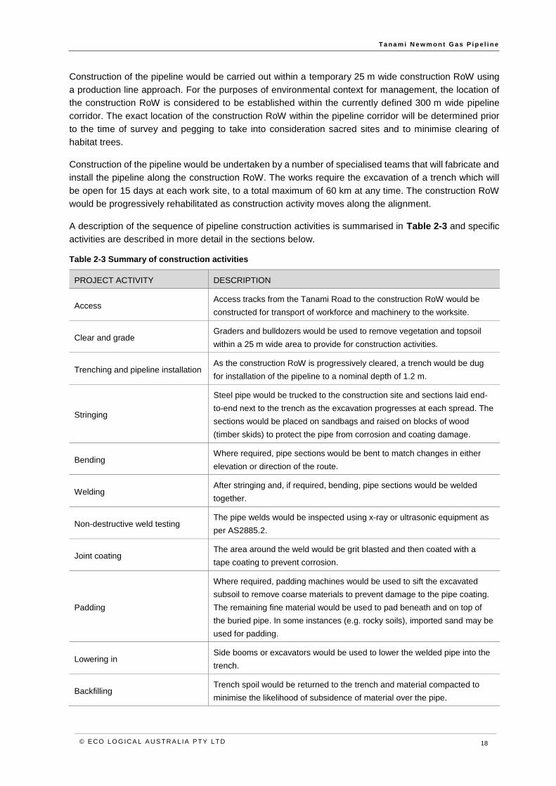
Table 2-3 Summary of construction activities .......................................................................................... 18
Table 2-4 Anticipated crossings proposed for Horizontal Directional Drilling .......................................... 20
Table 2-5 Rehabilitation zones ................................................................................................................. 22
Table 3-1 Definitions of likelihood ............................................................................................................ 25
Table 3-2 Consequence ratings and definitions for terrestrial fauna ....................................................... 25
Table 3-3 Consequence ratings and definitions for flora ......................................................................... 26
Table 3-4 Risk matrix ............................................................................................................................... 26
Table 3-5 Summary of inherent and residual construction risks to threatened species .......................... 28
Table 3-6 Summary of inherent and residual operational risks to threatened species ............................ 32
Table 5-1 Records of MNES in the Project area ...................................................................................... 38
Table 5-2 Fauna habitats recorded in the Project area and value to MNES ........................................... 40
Table 6-1 Great Desert Skink guidance ................................................................................................... 42
Table 6-2 Greater Bilby guidance............................................................................................................. 43
Table 6-3 Night Parrot guidance .............................................................................................................. 43
Table 6-4 Princess Parrot guidance ......................................................................................................... 44
Table 6-5 Dwarf Desert Spike-rush guidance .......................................................................................... 44
Table 7-1 Likely preferred habitat and vegetation communities for Great Desert Skink in the Project area
.................................................................................................................................................................. 50
Table 8-1 Likely preferred habitat and vegetation communities for Greater Bilby in the Project area ..... 58
Table 9-1 Likely preferred habitat and vegetation communities for Night Parrot in the Project area ...... 66
Table 10-1 Likely preferred habitat and vegetation communities for Princess Parrot in the Project area
.................................................................................................................................................................. 73
T a na m i N e wm o n t G as P i p e l i n e
© E CO LO G ICA L A U S T RA L IA P T Y LT D viii
Abbreviations
ABBREVIATION DESCRIPTION
AGIG Australian Gas Infrastructure Group
AGIT AGI Tanami Pty Ltd
AGN Australian Gas Networks
AS Australian Standard
CEMP Construction Environment Management Plan
DBNGP Dampier Bunbury Natural Gas Pipeline
DBP Dampier Bunbury Pipeline
EA Act Environmental Assessment Act
EMP Environmental Management Plan
EPA Environmental Protection Authority
EPBC Act Environment Protection and Biodiversity Conservation Act 1999
HDD Horizontal Directional Drilling
HSE Health, Safety and Environment
MNES Matters of National Environmental Significance
NOI Notice of Intent
NT Northern Territory
OEMP Operational Environment Management Plan
RFI Request for Information
RoW Right of Way
TND Turkeys nest dam
TNP Tanami Newmont Gas Pipeline

T a na m i N e wm o n t G as P i p e l i n e
© E CO LO G ICA L A U S T RA L IA P T Y LT D 1
1 Introduction
1.1 Purpose of report
This Preliminary Documentation assesses the significance of potential impacts of the proposed Tanami
Newmont Gas Pipeline (TNP) (the Project) to MNES, to support the assessment of the Project, under the
Environment Protection and Biodiversity Conservation Act 1999 (EPBC Act; EPBC Act ref 2017/7997).
1.2 Summary of proposed act ion
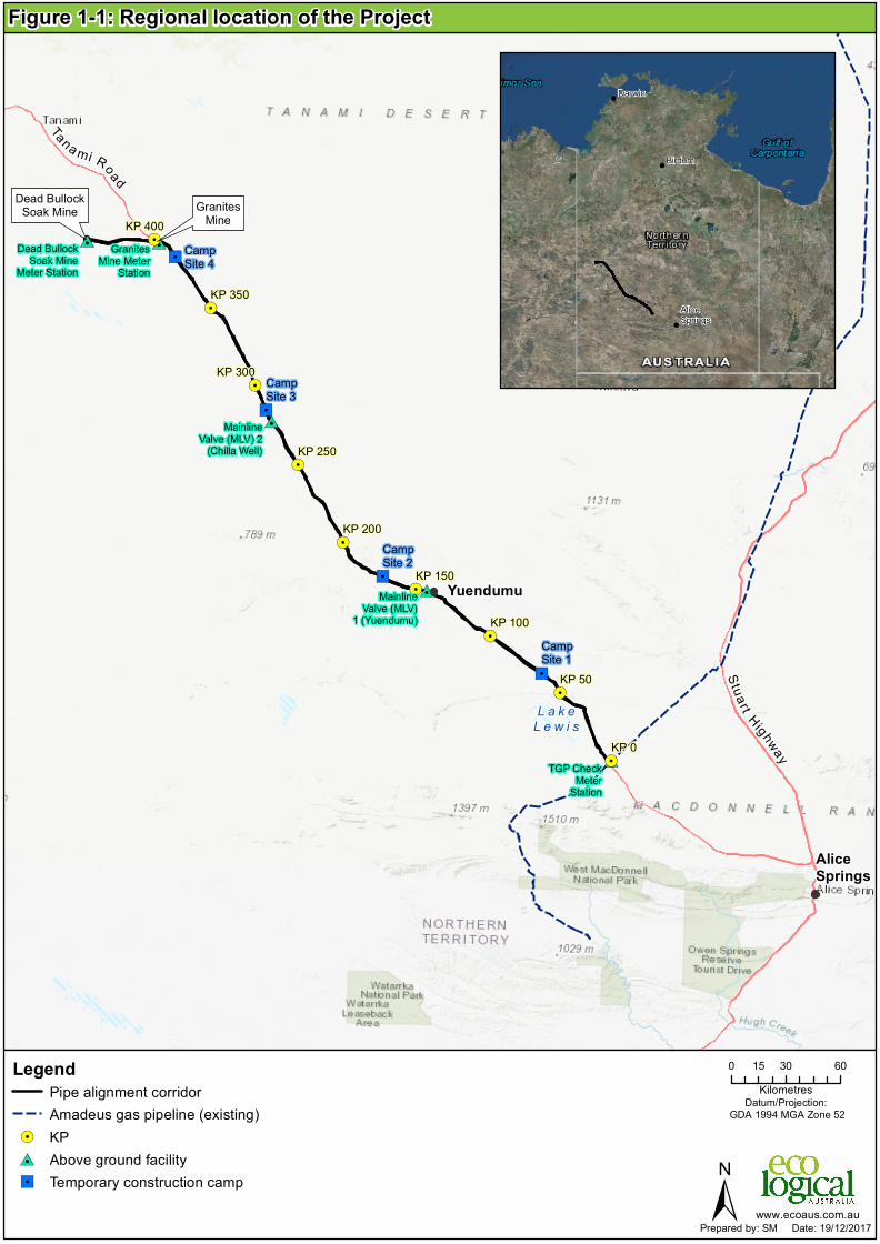
AGI Tanami Pty Ltd (AGIT) are proposing to develop the Project, a 440 km buried pipeline to connect the
Amadeus Gas Pipeline to the Granites and Dead Bullock Soak mines, in the Northern Territory (Figure
1-1).
The Project includes clearing of a temporary 25 m pipeline construction Right of Way (RoW) to
accommodate the buried pipeline, construction of temporary access tracks to the construction RoW,
establishment of temporary construction camps for the workforce, additional clearing for ancillary activities
such as turn-around points and turkeys nest dams, a permanent 5 m access track between KP0-3 and
KP390-440 and above ground facilities for pipeline operation including:
• Tanami meter station (at tie-in with the Amadeus Gas Pipeline).
• Two scraper stations located along the pipeline.
• Granites Mine meter station.
• Dead Bullock Soak Mine meter station.
1.3 The Proponent – AGIT
The proponent of the Project is AGI Tanami Pty Ltd (AGIT). AGIT is part of the Australian Gas
Infrastructure Group (AGIG) and was formed specifically for the construction and operation of the TNP.
AGIG came together following the acquisition in 2017 of the DUET Group by the CK Infrastructure
Holdings Limited led consortium comprising CKI, CK Asset Holdings Limited and Power Asset Holdings
Limited, which combined the operations of Dampier Bunbury Pipeline (DBP), Australian Gas Networks
(AGN) and Multinet. AGIG’s origins date back almost 150 years to the gas distribution networks of the
former South Australian and Brisbane Gas Companies, and the Gas and Fuel Corporation of Victoria.
AGIG comprises the following operations:
• DBP, the owner and operator of the 1,600 km Dampier Bunbury Natural Gas Pipeline in
Western Australia.
• DBP Development Group (DDG), the owner and operator of a variety of gas pipelines and
gas storage infrastructure in the Pilbara region of Western Australia.
• Multinet, which distributes natural gas to over 687,000 customers throughout Melbourne’s
inner and outer east, the Yarra Ranges and South Gippsland.
• AGN, one of Australia's largest natural gas distribution companies which owns approximately
25,000 kilometres of natural gas distribution networks and 1,100 kilometres of natural gas
pipelines, serving over 1.2 million consumers in South Australia, Victoria, Queensland, New
South Wales and the Northern Territory. AGN owns the Palm Valley Pipeline in the Northern
Territory and the Wide Bay Pipeline in Queensland.
T a na m i N e wm o n t G as P i p e l i n e
© E CO LO G ICA L A U S T RA L IA P T Y LT D 2
Additionally, AGIG has undertaken similar projects to build, own, operate and maintain gas transmission
pipelines and associated hydrocarbon infrastructure in Western Australia including:
• Wheatstone Ashburton West Pipeline – 100 km pipeline for the purpose of domestic gas
export from the Wheatstone gas plant.
• Fortescue River Gas Pipeline – 270 km pipeline to supply gas to Fortescue Mining Group’s
iron ore mining operations in the Solomon Hub.
• Ashburton Onslow Gas Pipeline – 24 km pipeline supplying gas to the Onslow Power
Station.
Note that the Project was originally referred under the EPBC Act by DBP Development Group (specifically
DDG Operations Pty Ltd) as the proponent. Due to changes in DDG’s parent company structure as
outlined above, AGIT is now the proponent. This change was approved by the Australian Government
Department of the Environment and Energy (DotEE) on 12 January 2018.
"/
"/
"/
"/#0
#0
#0
#0#0
!.
!.
!.
!.
!.
!.
!.
!.
!.
GranitesMine
Dead BullockSoak Mine
L a k eL e w i s
AliceSprings
Yuendumu
KP 0
KP 50
KP 100
KP 150
KP 200
KP 250
KP 300
KP 350
KP 400
MainlineValve (MLV)
1 (Yuendumu)
MainlineValve (MLV) 2
(Chilla Well)
TGP CheckMeter
Station
GranitesMine Meter
StationDead Bullock
Soak MineMeter Station
CampSite 1
CampSite 4
CampSite 3
CampSite 2
0 30 6015Kilometres
LegendPipe alignment corridorAmadeus gas pipeline (existing)
!. KP#0 Above ground facility"/ Temporary construction camp ±
Datum/Projection: GDA 1994 MGA Zone 52
www.ecoaus.com.au
Figure 1-1: Regional location of the Project
Prepared by: SM Date: 19/12/2017
Tana mi Road
!
!
!
AliceSprings
Darwin
BirdumStua rt Highway

T a na m i N e wm o n t G as P i p e l i n e
© E CO LO G ICA L A U S T RA L IA P T Y LT D 4
1.4 Assessment and approval process
Australian Government
The Project was referred to the DotEE on 27 July 2017 (EPBC Ref 2017/7997). On 12 October 2017, the
delegate for the Minister for the Environment and Energy determined that the Proposal is a Controlled
Action under Section 75 of the EPBC Act therefore requiring further assessment and approval under the
EPBC Act (Appendix C). The controlling provision is ‘Listed threatened species and communities’ (Section
18 and 18A of the EPBC Act), with potential to significant impacts on the MNES listed in Table 1-1.
The assessment approach was determined as Preliminary Documentation and a Request for Information
was provided to AGIT on 6 December 2017. Section 1.6 highlights where the required information is
included in the document.
Table 1-1 Threatened species relevant to this assessment
SPECIES EPBC ACT STATUS
Fauna
Greater Bilby (Macrotis lagotis) Vulnerable
Great Desert Skink (Liopholis kintorei) Vulnerable
Night Parrot (Pezoporus occidentalis) Endangered
Princess Parrot (Polytelis alexandrae) Vulnerable
Flora
Dwarf Desert Spike-rush (Eleocharis papillosa) Vulnerable
Northern Territory
The Project was referred to the Northern Territory Environmental Protection Authority (NT EPA) on 25
July 2017 for consideration under the Environmental Assessment Act (EA Act) through submission of a
Notice of Intent (NOI).
The NT considered the NOI and decided that the Project is unlikely to have a significant impact on the
environment and does not require assessment under the EA Act. This decision is in accordance with
clause 8(2)(b) of the Environmental Administrative Procedures. The NT EPA recommended a number of
measures be implemented during the construction and operation of the Project, as identified in the Letter
to AGIT and accompanying Statement of Reasons (Appendix D). In summary, these measures include:
• Restrict the permanent access track to between KP0-3 and KP390-440. The remainder of
the alignment should be rehabilitated.
• Prepare and implement a number of plans, including:
o Rehabilitation management plan.
o Weed management plan.
o Fauna management plan.
The Energy Pipelines Act and Energy Pipeline Regulations authorises the survey, construction, testing
and operational activities of the Project. A pipeline licence under the Energy Pipelines Act is required
before construction or operation of the pipeline can commence. Environmental conditions, including those
arising from recommendations flowing from the assessment under the EA Act, will be placed on the
T a na m i N e wm o n t G as P i p e l i n e
© E CO LO G ICA L A U S T RA L IA P T Y LT D 5
pipeline licence. A Pipeline Management Plan, incorporating the EMP is required for the licence. The
constructor will develop and implement a Construction Environmental Management Plan (CEMP) and
Operational Environmental Management Plan (OEMP) that conforms with and supports this EMP.
The Planning Act (NT) authorises the clearing of native vegetation on freehold land in the Northern
Territory. Applications to clear native vegetation are required under Section 46(3) of the Planning Act and
the application must demonstrate consideration of land clearing guidelines, presence of threatened
wildlife, sensitive or significant vegetation communities, impacts on regional biodiversity, soils and
topography, surface water, heritage properties and presence of Aboriginal sacred sites. AGIT will prepare
and submit applications to clear native vegetation to the Northern Territory Department of Environment
and Natural Resources. A 'Statement of Effect' will be prepared as part of the application which will be
subject to public notification and exhibition. Applications are reviewed by the Native Vegetation
Assessment Panel and considered against the performance criteria in clauses 10.2 and 10.3 of the
Northern Territory Planning Scheme and the 'Land Clearing Guidelines: Northern Territory Planning
Scheme.
Consent for clearing of native vegetation on pastoral leasehold land is not expected to be required, as the
conveying of gas across the land is a prescribed purpose under regulation 31(b) of the Pastoral Lands
Regulations, allowing for the Minister to consent to the sub-letting of the land required for the Project
under s68(5) of the Pastoral Lands Act.
Associated regulatory framework and industry standards
In addition to the primary environmental approvals, the Project will be constructed and operated in
accordance with a range of Northern Territory and Commonwealth laws requiring secondary approvals
of specific activities (such as native vegetation clearing) or obligations with respect to cultural heritage
management, and protection of public and worker health and safety. These are identified in Table 1-2
below.
Table 1-2 Secondary approvals and regulations
LEGISLATION RELEVANCE TO TANAMI NEWMONT GAS PIPELINE
Commonwealth laws
Aboriginal and Torres Strait Islander
Heritage Protection Act 1984
Preservation and protection of areas and objects that are of particular
significance to Aboriginal people in accordance with Aboriginal
tradition.
Aboriginal Land Rights (Northern
Territory) Act 1976
Grants traditional Aboriginal land in the Northern Territory for the
benefit of Aboriginals, and for other purposes.
Native Title Act 1993
Recognises and protects native title and establishes a mechanism for
determining native title claims and provides for the validation of past
acts.
Northern Territory laws
Dangerous Goods Act
Dangerous Goods Regulations
Handling and storage of hazardous and explosive materials will need
to conform to the requirements of the Act and Regulations.

T a na m i N e wm o n t G as P i p e l i n e
© E CO LO G ICA L A U S T RA L IA P T Y LT D 6
LEGISLATION RELEVANCE TO TANAMI NEWMONT GAS PIPELINE
Heritage Act All sites of Aboriginal archaeology are protected and will require pre-
clearance survey and permit if materials are to be disturbed. Declared
heritage places are protected and will need to be avoided or consent
obtained if site is to be disturbed.
Northern Territory Aboriginal Sacred
Sites Act
Provides for the identification and protection of Aboriginal sacred sites.
Consultation on sacred sites will occur through the Central Land
Council and an Authority Certificate will be sought from the Aboriginal
Areas Protection Authority to ensure that sacred sites are protected.
Planning Act Requires development consent for clearing native vegetation on zoned
and unzoned freehold land, as discussed above.
Public and Environmental Health Act Operation of construction camps, particularly on-site disposal of
sewage will need to comply with the provisions and codes called up in
the Act.
Soil Conservation and Land Utilisation
Act
Addresses soils conservation, erosion and land capability. Erosion and
Sediment Control Plans prepared for the Project will need to be
consistent with objects of the Act.
Territory Parks and Wildlife
Conservation Act
Protects native wildlife (flora and fauna) and establishes the Northern
Territory listing of threatened species. Surveys and any removal or
relocation of threatened species arising from the Project will require a
permit.
Traffic Act and Regulations Establishes the traffic laws relevant to the Project.
Waste Management and Pollution
Control Act
Establishes general environmental duty and regulates offsite solid and
hazardous waste disposal, licenses some landfill operations and
applies the National Environment Protection Measure for Air Quality.
Water Act Requires extraction of surface and ground waters, and discharge into
waterways to be licensed. Construction of surface water storage and
interference with a waterway requires consent. Bore construction
requires a permit.
Weeds Management Act Declares weeds, specifies management requirements and adopts
management plans providing detailed management measures. The
Weed Management Plan prepared for the Project will need to be
consistent with the management objectives and measures specified in
the Act for weeds present along the alignment.
Work Health and Safety (National
Uniform Legislation) Act and
Regulations
Provides for authorisation of workplace, plant or substances
including licensing of high risk work and management of risk
for pipeline activities.
The Project will be designed, constructed and operated in accordance with AS 2885 Pipelines – Gas and
Liquid Petroleum. The relevant components of this standard are listed below:
• AS 2566.1: Buried flexible pipelines – Structural Design.
• AS 2885.1: Gas and Liquid Petroleum: Design and Construction.

T a na m i N e wm o n t G as P i p e l i n e
© E CO LO G ICA L A U S T RA L IA P T Y LT D 7
• AS 2885.2: Gas and Liquid Petroleum: Welding.
• AS 2885.3: Gas and Liquid Petroleum: Operation and Maintenance.
• AS 2885.5: Field Pressure Testing.
Australian Pipelines and Gas Association: Code of Environmental Practice Onshore Pipelines (2013)
The Australian Pipelines and Gas Association: Code of Environmental Practice Onshore Pipelines (2013)
(the Code) has been established to define the minimum acceptable standard and encourage the adoption
and integration of practical and effective environmental management systems and procedures to be
applied to onshore pipeline construction, operation and decommissioning. AGIT reflects the objectives,
intent and advice contained within the Code into the Project controls contained within the CEMP and
OEMP.
1.5 Approach to impact assessment
The comprehensive assessment of potential impacts to MNES has been undertaken including impacts to
threatened species recorded or considered likely, or with potential to occur in the Project area. The impact
assessment process includes the following:
• Assessment of Project related risks including likelihood and consequences, to identify key
impacts that may arise as a result of the Project.
• Review of the flora and vegetation survey of the Project area, including vegetation
communities present.
• A review of the fauna survey of the Project area including desktop findings, identification and
mapping of fauna habitat types available in the Project area.
• Spatial analysis of vegetation communities, fauna habitats and species records to determine
potential impacts to species recorded or likely to occur in the Project area.
• The assessment also considers approved conservation advice for each threatened species,
in particular, whether a population is an important population and whether available habitat
in the Project area is critical habitat for the local population or species.
• Application of the mitigation hierarchy including avoidance, prevention and control measures
to manage potential impacts to MNES, as detailed in the EMP.
1.6 Request for information
The following table identifies where this document addresses the requirements of the Request for
Information.
Table 1-3 Request for Information requirements
REQUEST FOR INFORMATION ITEM SECTION IN THIS DOCUMENT
1. Listed threatened species and ecological communities
Demonstrate that targeted surveys undertaken for MNES Section 5.2
Results of surveys Section 5.2 and Sections 7 to 11
Analysis of the likely direct and indirect impacts of the
proposed action on the relevant species Sections 7 to 11
Identify all measures proposed to avoid or mitigate the likely
impacts Sections 7 to 11

T a na m i N e wm o n t G as P i p e l i n e
© E CO LO G ICA L A U S T RA L IA P T Y LT D 8
REQUEST FOR INFORMATION ITEM SECTION IN THIS DOCUMENT
An analysis of the effectiveness of proposed avoidance and
mitigation measures Sections 7 to 11
2. Environmental Offsets Sections 7.6, 8.6, 9.6, 10.6 and 11.4
3. Threat Abatement Plans and Recovery Plans
• Demonstrate that the proposed action is not
inconsistent with a relevant recovery plan or
threat abatement plan.
Sections 6.2 and 6.3
Sections 7.6, 8.6, 9.6 and 10.6
4. Conservation Advices
• Demonstrate that the above actions were
undertaken having regard to the species
conservation advice
Sections 6.2 and 6.3

T a na m i N e wm o n t G as P i p e l i n e
© E CO LO G ICA L A U S T RA L IA P T Y LT D 9
2 Project description
2.1 Project location
The pipeline alignment ties into the Amadeus Gas Pipeline adjacent to the Tanami Road Scraper Station
and follows a north-westerly route, along the north-eastern side of Tanami Road outside of the existing
road reserve.
The Project passes through Aboriginal Freehold, Pastoral Land and Crown Land tenures. Most of the
pipeline alignment occurs within the Central Desert Regional Council, with a small section located within
the MacDonnell Regional Council (near the tie-in with the Amadeus Pipeline).
2.2 Project optimisation
Throughout the design phase of the Project, the pipeline alignment and extent of disturbance have been
optimised to avoid and minimise potential impacts to MNES. The original Project design included a 30 m
construction RoW for the pipeline corridor, which is consider the industry standard width. The construction
RoW has been reduced to 25 m, reducing the total temporary disturbance by 220 ha.
The final residual disturbance has been reduced from a 5 m access track for the full length of the pipeline
to a restricted 5 m access track between KP0-3 and KP 390-440 and above ground infrastructure, totalling
130 ha to allow access for essential pipeline inspection and maintenance.
The construction period has been minimised to less than 12 months, to reduce the duration of temporary
ground disturbance and associated potential impacts to MNES in the vicinity of the Project.
2.3 Design
The Project will comprise a 440 km, 8 inch class 600 buried high-pressure gas transmission pipeline
designed to deliver a firm free flow capacity of 13.6 TJ per day of 5,500 kPa at the Amadeus Gas Pipeline.
Key design parameters for the Project are shown in Table 2-1.
Table 2-1: Design parameters
PARAMETER TANAMI NEWMONT GAS PIPELINE LATERAL
From: To
Amadeus Gas Pipeline’s Tanami Road
Scraper Station to Newmont’s Dead
Bullock Soak Mine
Tanami Newmont Gas Pipeline KP395
Offtake to Newmont’s Granites Mine
Pipeline length (km) 440 1
Nominal size (mm) 200 200
Nominal wall thickness
(mm) 5.6
5.6
Critical defect length (mm) 85 85
Measurement length (m) 267 267
Pipe steel grade (API 5L) X52 X52
Minimum yield strength
(MPa) 358.5
358.5

T a na m i N e wm o n t G as P i p e l i n e
© E CO LO G ICA L A U S T RA L IA P T Y LT D 10
PARAMETER TANAMI NEWMONT GAS PIPELINE LATERAL
Pipe specification ERW ERW
Fittings and valves Class 600 Class 600
MAOP (MPag) 10.2 10.2
Operating temperature
range (°C) 0-60
0-60
Nominal earth cover (mm) 750 750
External corrosion coating 3LPE 3LPE
Cathodic protection IC IC
The Project design would enable additional future capacity to be delivered by:
• Installation of a compressor at the inlet of the pipeline and at the scraper stations (up to
26.3 TJ additional capacity per day)
• Sizing of pipeline diameter to meet current capacity requirements while allowing for future
capacity expansion
• Pipeline rating to Class 600, 10.2 MPa for higher capacity throughput
• Scraper stations spaced at optimal 100 km intervals with remote operable shutdown valve
and pig launching and receiving facilities for the efficient operation and maintenance of the
pipeline.
The pipeline design would include a future off-take near Yuendumu, should a future lateral pipeline be
constructed to supply gas to the Yuendumu power station.
2.4 Schedule
Construction of the pipeline is scheduled to begin in early 2018 and to be completed by early 2019. ‘First
gas’ to the Granites and Dead Bullock Soak mines is expected by early 2019.
The construction strategy allows for two spreads or work fronts operating concurrently to effectively
manage the construction schedule, weather and environmental conditions. One spread would commence
at the Amadeus Gas Pipeline, working westwards to the mid-point of the pipeline alignment, and the
second crew would commence from the midpoint of the alignment and work westwards to the mine site.
Depending on construction requirements this may change and include additional work fronts to complete
work if delays occur (i.e. wet weather, delivery of materials). No additional risks are foreseeable from this
acceleration of work and all controls outlined in this EMP shall be implemented as required.
2.5 Project components
The Project components include clearing of a temporary 25 m pipeline construction RoW within which the
pipeline will be buried, construction of temporary access tracks to the construction RoW, establishment
of temporary construction camps for the workforce, additional clearing for ancillary activities such as turn-
around points, and above ground facilities for the operation of the pipeline (metering station, mainline
valves and tie-in stations). The location of project components is depicted in Figure 2-1.

"/
"/
"/
"/
!(!(!(
!(
!(!(
!(!(
!(
!(
!(
!(
!(!(
!(
!(!(
!(
!(
!(
!(
!(
!(
!(
!(
!(
!(
!(
!(
!(
!(
!(
!(
!(
!(
!(
!(
!(
!(
!(!(!(!(!( !(!(
#0
#0
#0
#0#0
!.
!.
!.
!.
!.
!.
!.
!.
!.
AliceSprings
Yuendumu
KP 0
KP 50
KP 100
KP 150
KP 200
KP 250
KP 300
KP 350
KP 400
MainlineValve (MLV)
1 (Yuendumu)
MainlineValve (MLV) 2
(Chilla Well)
TGP CheckMeter
Station
GranitesMine Meter
StationDead Bullock
Soak MineMeter Station
CampSite 1
CampSite 4
CampSite 3
CampSite 2
0 30 6015Kilometres
LegendPipe alignment corridor
!. KP!( Access road point to ROW#0 Above ground facility"/ Temporary construction camp
Main roadAccess track
±
Datum/Projection: GDA 1994 MGA Zone 52
www.ecoaus.com.au
Figure 2-1: Location of project components
Prepared by: SM Date: 19/12/2017
Tana mi RoadStuar t H ig hw
ay

T a na m i N e wm o n t G as P i p e l i n e
© E CO LO G ICA L A U S T RA L IA P T Y LT D 12
Above ground facilities
Five above ground facilities are proposed including:
• Tanami meter station (at tie-in with the Amadeus Gas Pipeline)
• Two scraper stations located along the pipeline
• Granites Mine meter station
• Dead Bullock Soak Mine meter station.
Tanami meter station (Tie-in)
The Tanami meter station would be located adjacent to the Amadeus Gas Pipeline (KP0) and include the
following:
• Coalescing filters
• Metering
• Flow control
• Solar power with battery backup
• Flow computers
• Satellite communication
• Remote operable shutdown valve
• Pig launcher and valves
• Offtake for future compression.
Scraper station 1 and 2
Scraper station 1 would be located near Yuendumu (KP130). Scraper station 2 would be located at Chilla
Well (KP278). Both facilities would include the following:
• Remote operable shutdown valve
• Pig receiver
• Pig launcher
• Provision for future compression
• Solar power with battery back up
• Communications via satellite.
Granites Mine meter station
The Granites Mine meter station would be located at Granites Mine site (KP395) and include the following:
• Remote operable shutdown valve
• Filtration
• Electric Immersion heater
• Dual runs with single run meter skid
• Spec break and pressure reduction skid
• Communications via satellite or wireless
• AC power from mine site, with battery back-up.
Dead Bullock Soak Mine meter station
The Dead Bullock Soak Mine meter station would be located at the Dead Bullock Soak Mine (KP440) and
include the following:
• Pig Receiver and remote operable shutdown valve
• Filtration
• Electric Immersion heater

T a na m i N e wm o n t G as P i p e l i n e
© E CO LO G ICA L A U S T RA L IA P T Y LT D 13
• Single run meter skid
• Spec break and pressure reduction skid
• Communications via satellite or wireless
• AC power from mine site, with battery back-up.
Ground disturbance
Construction of the Project will require clearing of up to 1100 ha of native vegetation for the construction
corridor, plus 35.48 ha for access tracks, camps and other components, totalling 1136 ha). The majority
of the disturbance footprint (1108 ha) will be rehabilitated and allowed to return to native vegetation over
time. The total permanent disturbance footprint will be up to 28 ha, which is required for a 5 m wide access
track from KP0-3 and KP390-440 to enable ongoing access for maintenance of the pipeline, for
permanent above ground facilities, and for permanent access tracks from the Tanami Road to the
pipeline.
As part of minimising environmental impacts, AGIT has worked with the construction contractor to reduce
the construction corridor from an originally proposed (NOI) 30 m down to 25 m, eliminating approximately
220 ha of clearing.
The extent of disturbance is identified in Table 2-2.
Table 2-2 Temporary and permanent disturbance
PROJECT COMPONENT AREA DISTURBED
(HA)
AREA
REHABILITATED
(HA)
PERMANENT
DISTURBANCE (HA)
Construction corridor
440 km (pipeline length) x 25 m
(construction RoW)
1,100 1,074 26
Construction access tracks
(Tanami Road to construction
corridor comprising 40 tracks at
approximately 120 m by 6 m))
2.88 Approximately 50%
will be rehabilitated
1.44
1.44
Camps (7.5 ha x 4) includes
laydown and pipeyard
30 30 0
Borrow pits Already existing N/A N/A
Permanent facilities 1 0.8 0.2
Turkeys nest dams 1.5 1.5 0
Telecommunications 10 sites at
10 m x 10 m
0.1 0.1 0
TOTAL 1,135.48 (1,136 ha) 1,107.84 (1,108 ha) 27.64 (28 ha)
Access tracks
The positioning of the Project alignment close to, and parallel with, the existing Tanami Road significantly
reduces the requirement for additional constructed site access for the Project. Construction access from
the Tanami Road would require construction of 40 access tracks (120 m in length by 6 m wide) to link to
the construction RoW. Clearing of up to 2.88 ha of native vegetation is estimated to be required for
construction of these access tracks. A proportion (approximately half in total area) of the tracks would be

T a na m i N e wm o n t G as P i p e l i n e
© E CO LO G ICA L A U S T RA L IA P T Y LT D 14
required for permanent access to the construction RoW from the Tanami Road and the remainder would
be rehabilitated after the construction phase.
Post-construction, a 5 m wide permanent access track within the construction RoW is required to be
maintained between KP0 and KP3 as well as between KP390 and 440 for ongoing access and
maintenance over the period of pipeline operation. Operational access to the remainder of the length of
pipeline alignment would be achieved through the construction access tracks remaining post-construction
as well as potential use of existing pastoral station tracks in consultation with pastoral landholders.
Operationally, access would only be required for cathodic protection surveys, repairs of washouts and
access to above ground facilities (apart from in an emergency). The OEMP requires all vehicles to stay
within designated access tracks only.
2.6 Other construct ion requirements
Workforce
A workforce of between 250 and 350 people would be required during the construction period. The roster
for the main construction work crew is anticipated to be 28 days on site and 9 days off-site. Rest and
recreation breaks would be taken by the entire construction workforce at the same time with only a
skeleton crew remaining on site during these breaks.
Peak workforce is not required for the entire construction phase. Workforce numbers would ramp up over
11 week mobilisation period, peak at a work force of approximately 270-310 over a period of 10 weeks,
and then steadily wind down over a 15 week demobilisation period.
Construction camps
The construction workforce is proposed to be accommodated in temporary workcamps, generally
established no greater than 50 km from the work front. The workcamps will have a capacity of 120 people
each and will move to a new location at approximately 100 km intervals, as construction proceeds.
Construction will initially require two camps and at the peak, require up to four operational camps with
varying occupancy.
Construction camps are proposed to be located adjacent to the Tanami Road at: KP65, KP170, KP285
and KP385. Each camp would have a footprint of 300 m by 250 m. Facilities and infrastructure at each
construction camp would include:
• Accommodation facilities
• Messing facilities
• Toilet, shower and laundry facilities
• Entertainment/recreation facilities
• Power generator
• Water storage.
• Package sewage treatment plant
• Site offices including paramedic
• Pipe laydown area
• Workshops
• Car parking
As part of the well-being and solutions to enhance integration and management of workforce in remote
isolation, the camp will have a wet mess with limited number of low alcohol beverages served.

T a na m i N e wm o n t G as P i p e l i n e
© E CO LO G ICA L A U S T RA L IA P T Y LT D 15
Water supply
Water demands for the Project are predicted to include:
• Potable camp water: 90 KL / per day during peak construction.
• Construction/Process Water (roads and hydrotesting): 5.25 ML/per week during peak
construction and approximately 2.52 ML / week during off-peak construction (pre and post
trenching).
Water supply for the Project will be sourced from a combination of the following options:
• Established bores near the pipeline alignment.
• Turkey nest dams to contain bore supplies.
• Potable water carted from Alice Springs with some also supplied from Newmont.
Construction water
Bore testing was completed along the Tanami Highway in June-July 2017 on behalf of the Department of
Infrastructure, Planning and Logistics (DIPL). The bore testing results indicate a high number of existing
bores that can be used for construction water (construction can operate at >1.5 L/s). As a priority, water
for construction would be sourced from existing bores along the Tanami Highway, as identified in the
DIPL study. Project bores would be refurbished as required, to ensure efficiency of abstraction. This will
be undertaken with the potential future needs of other users in mind, particularly for road maintenance
and upgrade activities by the NT Government.
Project water needs would require a bore to be available every 45 km. On this basis, water haulage would
require a maximum of five trucks completing six loads per day, for a one way trip of 22.5 km. Actual
haulage distances along some parts of the pipeline alignment would be considerably less, where adjacent
bores are located in closer proximity.
Existing turkey nest dams for storage of bore water are established in conjunction with most of the
identified project bores. Minor refurbishment of these dams would be required and an additional six turkey
nest dams would be constructed for use in conjunction with the other project bores.
Some of the proposed project bores are located on pastoral properties (Narwietooma and Mt Doreen
pastoral leases) and have been used for stock watering. Affected pastoralists have been consulted on
the proposed water sourcing strategy. This would continue over the course of construction. Other owners
of proposed project bores include the NT Government (DIPL), Yuendumu Aboriginal Land Trust, and
North Flinders Mine.
None of the identified project bores supply township or community water needs in the region.
If the identified existing bores cannot supply all the construction water, new bores would be constructed
along the Tanami Road, in consultation with the land owner. Where new bores are drilled the pastoral
lessee or landowner will have the benefit of the new bores once the bores are no longer required for the
Project.
Management measures will be implemented to prevent and manage any potential impacts to surface and
groundwater which may arise from water use for the Project and to avoid and reduce potential impacts to
other water users in the vicinity of the Project.

T a na m i N e wm o n t G as P i p e l i n e
© E CO LO G ICA L A U S T RA L IA P T Y LT D 16
Potable water
It is likely that water from the identified existing bores will be of insufficient quality for potable supply to
the construction workforce, across the entire alignment. Haulage of potable water from Alice Springs is
proposed, to be supplemented with water from project bores if testing indicates the water quality is
adequate. Supply of potable water entirely from Alice Springs to meet project needs of 180 L/person/day
would require one truck movement every day during peak construction.
Extractive materials
Additional fill would be required for construction camps, laydown areas and some fill-in rock areas.
Volumes of fill required are not anticipated to be large (< 10,000 m3) and would be sourced from existing
borrow pits established for road maintenance, subject to consent.
Power
Power at the construction camps and work sites would be provided through diesel generators.
Waste
Subject to consultation and agreement with the relevant local government, existing approved municipal
landfill services would be used to dispose of non-hazardous waste, particularly waste deriving from
construction camps. Volumes of non-hazardous waste generated from construction camps over the
course of the Project would be approximately 2880 m3.
Sewage from construction camps would be treated on-site and disposed of in accordance with the Code
of Practice for On-site Wastewater Management (DoH 2014), and approval from the Department of
Health.
Hazardous wastes generated during construction would include hydrocarbon waste, paints, coating
residues, batteries, chemical drums and miscellaneous wastes (aerosols etc) and these would be
removed from site and transported to an approved facility for treatment and disposal. The quantities of
these wastes are expected to be small.
Transport and logistics
Pipe for the TNP Project would be manufactured overseas and is expected to be delivered to Darwin Port
and then transported by road to a pipe yard located in Darwin. The pipe would then be transported by rail
to Alice Springs, stored at a pipe yard located in Alice Springs and then transported by road via the Stuart
Highway and Tanami Road to the project area.
It is expected that local suppliers would provide loading and transport services for the Project.
The construction contractor would be responsible for providing the construction plant and equipment.
Depending on the origin, equipment may be transported from interstate by rail or road, or from overseas,
most likely into the Port at Darwin.
Typical plant and equipment to be transported to site includes:
• Bull dozers, loaders and graders
• Sideboom tractors and forklifts
• Trucks (water, fuel, mechanics) and trailer units
• Trenching and padding machines
• Welding rigs
T a na m i N e wm o n t G as P i p e l i n e
© E CO LO G ICA L A U S T RA L IA P T Y LT D 17
• Excavators, rock saws and wheel ditching machines
• Semi-trailers and low loaders (for equipment relocation)
• Mobile cranes
• Camp buildings.
Lighting
Generally, no night time work on the construction RoW is planned and lighting would not be required.
Specific requirements for lighting may be required in the following circumstances:
• At sites designated necessary for public safety
• Where hydrotesting or HDD is occurring
Construction camps will be lit at night.
Fuel and dangerous goods / hazardous materials
Diesel fuel would be required for construction equipment and accommodation camps. Where practicable,
diesel would be sourced from local service stations and roadhouses located along the pipeline route or
from Alice Springs.
Diesel would be trucked in to each construction camp, and stored in two tanks with estimated total
capacity of 50,000 litres per camp. Fuel storage tanks would be fully lined and bunded and comply with
AS-1940 and AS-1692.
Dangerous goods storage would be in designated areas and comply with AS-1940 and the requirements
of the Dangerous Goods Act and associated codes.
Fire management, emergency and incident response
No control burning is proposed as part of the TNP Project. Risks of fire ignition would arise from the
introduction of ignition sources, welding and other hot works. These risks are addressed in the Bushfire
sub-plan in the CEMP. Water trucks would be on-site to implement fire response measures.
Emergency and incident response measures are detailed in the CEMP including:
• Induction and training
• Job hazard analysis
• Incident management
• Emergency preparedness and response
• External reporting.
2.7 Pipeline construct ion
The pipeline would be constructed and operated in accordance with the requirements of AS 2885
Pipelines - Gas and Liquid Petroleum. The Australian Pipelines and Gas Association: Code of
Environmental Practice Onshore Pipelines (2013) (the Code) has been established to define the minimum
acceptable standard and encourage the adoption and integration of practical and effective environmental
management systems and procedures to be applied to onshore pipeline construction, operation and
decommissioning. AGIT reflects the objectives, intent and advice contained within the Code into the
project controls contained within the CEMP and OEMP.
T a na m i N e wm o n t G as P i p e l i n e
© E CO LO G ICA L A U S T RA L IA P T Y LT D 18
Construction of the pipeline would be carried out within a temporary 25 m wide construction RoW using
a production line approach. For the purposes of environmental context for management, the location of
the construction RoW is considered to be established within the currently defined 300 m wide pipeline
corridor. The exact location of the construction RoW within the pipeline corridor will be determined prior
to the time of survey and pegging to take into consideration sacred sites and to minimise clearing of
habitat trees.
Construction of the pipeline would be undertaken by a number of specialised teams that will fabricate and
install the pipeline along the construction RoW. The works require the excavation of a trench which will
be open for 15 days at each work site, to a total maximum of 60 km at any time. The construction RoW
would be progressively rehabilitated as construction activity moves along the alignment.
A description of the sequence of pipeline construction activities is summarised in Table 2-3 and specific
activities are described in more detail in the sections below.
Table 2-3 Summary of construction activities
PROJECT ACTIVITY DESCRIPTION
Access Access tracks from the Tanami Road to the construction RoW would be
constructed for transport of workforce and machinery to the worksite.
Clear and grade Graders and bulldozers would be used to remove vegetation and topsoil
within a 25 m wide area to provide for construction activities.
Trenching and pipeline installation As the construction RoW is progressively cleared, a trench would be dug
for installation of the pipeline to a nominal depth of 1.2 m.
Stringing
Steel pipe would be trucked to the construction site and sections laid end-
to-end next to the trench as the excavation progresses at each spread. The
sections would be placed on sandbags and raised on blocks of wood
(timber skids) to protect the pipe from corrosion and coating damage.
Bending Where required, pipe sections would be bent to match changes in either
elevation or direction of the route.
Welding After stringing and, if required, bending, pipe sections would be welded
together.
Non-destructive weld testing The pipe welds would be inspected using x-ray or ultrasonic equipment as
per AS2885.2.
Joint coating The area around the weld would be grit blasted and then coated with a
tape coating to prevent corrosion.
Padding
Where required, padding machines would be used to sift the excavated
subsoil to remove coarse materials to prevent damage to the pipe coating.
The remaining fine material would be used to pad beneath and on top of
the buried pipe. In some instances (e.g. rocky soils), imported sand may be
used for padding.
Lowering in Side booms or excavators would be used to lower the welded pipe into the
trench.
Backfilling Trench spoil would be returned to the trench and material compacted to
minimise the likelihood of subsidence of material over the pipe.

T a na m i N e wm o n t G as P i p e l i n e
© E CO LO G ICA L A U S T RA L IA P T Y LT D 19
PROJECT ACTIVITY DESCRIPTION
Pressure testing
Pipeline integrity will be verified using hydrostatic testing in accordance
with Australian Standard (AS) 2885.5 or the American Society of
Mechanical Engineers Code for Pressure Piping (B31.3) as required.
Signage Information signs on the presence of the buried pipeline will be erected in
line of sight along the pipeline construction RoW as per AS 2885.1.
Restoration and rehabilitation
The construction RoW will be re-contoured and erosion controls
constructed to ensure a stable landform. Rehabilitation and return of areas
of temporary disturbance to native vegetation will be facilitated by re-
spreading stockpiled vegetation, re-seeding if appropriate, monitoring
against the rehabilitation criteria and corrective actions as per the
Rehabilitation sub-plan of the EMP.
Clear and grade
Graders and bulldozers would be used to remove vegetation and topsoil within the temporary 25 m wide
construction RoW, to provide the worksite for construction activities. Vegetation would be pushed aside
and residual vegetative material stockpiled in windrows for final re-spreading out over the reinstated
ground following trench backfill.
Topsoil would be graded to a depth of 100 to 150 mm and stockpiled separately from overburden, for
return to the source area during rehabilitation.
Trenching
As the construction RoW is progressively cleared, a trench would be dug for installation of the pipeline in
accordance with pre-defined depths of burial. Typically, the trench would be 1.2 m deep however this may
increase where necessary to protect the pipe. Geotechnical assessment of possible ground conditions
indicates that trenching techniques would be suitable for most of the length of the pipeline alignment. The
need for rocksaw and/or drill techniques is expected to be very low.
Trench spoil would be stockpiled in the construction RoW, usually on the non-working side, and separately
to topsoil. The period that any part of the trench is left open would be minimised by, where possible,
delaying trenching until completion of welding and joint coating. Measures to reduce risks of fauna
entrapment would be employed as detailed in the EMP (Terrestrial Fauna and Habitat sub-plan; and
Trench Clearing Procedure in Appendix I).
Crossings
The proposed alignment would require the Project to cross watercourses, roads and infrastructure
corridors. Specialised techniques for installing the pipeline would be employed at crossing locations.
Watercourse crossings
Watercourses in the Tanami region are ephemeral, flowing infrequently and unpredictably. Under the
most likely conditions during construction, watercourses would be dry and the preference would be to
install the pipeline at dry or no-flow, using open cut (trenching) methods.
Clear and grade would be conducted within a reduced construction RoW working width and significant
riparian vegetation avoided where possible. The pipeline trench would be excavated to achieve a
minimum cover above the pipeline of 1.5 to 2 m. Pipe bends required to profile the pipeline into and out
of the river would generally be formed on-site, and the welded pipe placed in the trench. The excavated
material would be returned into the trench and the disturbed area reinstated.
T a na m i N e wm o n t G as P i p e l i n e
© E CO LO G ICA L A U S T RA L IA P T Y LT D 20
Erosion and sediment control measures including 'rip-rap' and seed mats would be implemented and the
cross-sectional profile of the watercourse would be reinstated to pre-construction condition.
In the unlikely event that the ephemeral watercourses are in flow during the construction phase:
• Flow would be temporarily diverted around the work area using flume pipes or partial weirs
and the open trench techniques would then be implemented. Silt fencing at the temporarily
dry work area would be installed to reduce silt movement beyond the excavation and to
contain stockpiled spoil.
• At watercourse crossings that have high environmental or cultural values, or other significant
construction constraints, horizontal direct drilling (HDD) techniques would be used. There
are approximately 11 HDD crossings including crossings of watercourses and roads as
indicated in Table 2-4, the number of which will be finalised following completion of
Aboriginal Sacred Site consultations and the determination of restricted work areas. A further
five HDD crossings will be constructed at roads.
• A hole would be drilled into the ground at one side of the crossing at an angle, curving
underneath the watercourse and surfacing on the other side of the crossing. The pipeline
would then be pulled through the resultant tunnel. HDD is a specialised technique using a
drill rig designed for purpose and operated by a specialist contractor.
• The setback distances of the entry and exit pits for HDD crossings would be assessed on-
site and established to avoid riparian vegetation, account for the profile of the watercourse
and reduce risks of damage from flooding. Additional working areas at distance from the
crossing may be required to maintain a straight path for the pipe string, where the
construction RoW approaches or leaves the crossing at an angle. Saturated cuttings and
drilling mud would be displaced from the drilled hole and spread across the pipeline
construction RoW to dry and form part of the reinstatement.
Road Crossings
• Unsealed roads would be crossed using open cut method methods, subject to approval.
Standard trenching would be employed, the welded pipe placed in the trench, excavated
material returned, and the disturbed area then reinstated. By-passes or steel plates would
be employed to maintain vehicle access. Appropriate signage and other traffic control
measures would be employed to ensure safety. The road surface would be returned to pre-
construction condition.
• Bored installation (similar to HDD) using an auger would be employed to minimise traffic
disruption at a number of road crossings.
Table 2-4 Anticipated crossings proposed for Horizontal Directional Drilling
CROSSING KP REASONS
Napperby Creek
(Tilmouth) T1 34
To avoid Tlmouth Service Station, facilities and communication
tower. Minimise disturbance to Napperby Creek
Reduced construction
ROW to 10m – Stuart
Range
48 Cultural sensitivity
Road Reserve Dams 119
Yaloogarrie Creek (two
crossings) 180, 184 Environmental sensitivity at crossing of watercourse
T a na m i N e wm o n t G as P i p e l i n e
© E CO LO G ICA L A U S T RA L IA P T Y LT D 21
CROSSING KP REASONS
Chilla Well Watercourse 265 Environmental sensitivity at crossing of watercourse
Tanami Road crossing 401 Avoid road and traffic disruption from pipeline lateral
Dead Bullock Soak Mine
Road 436 Avoid road and traffic disruption from mainline
Dead Bullock Soak Mine
Road at final termination 439 Avoid road and traffic disruption from mainline
Tanami Road 0.19
Granites Mine Road 0.78
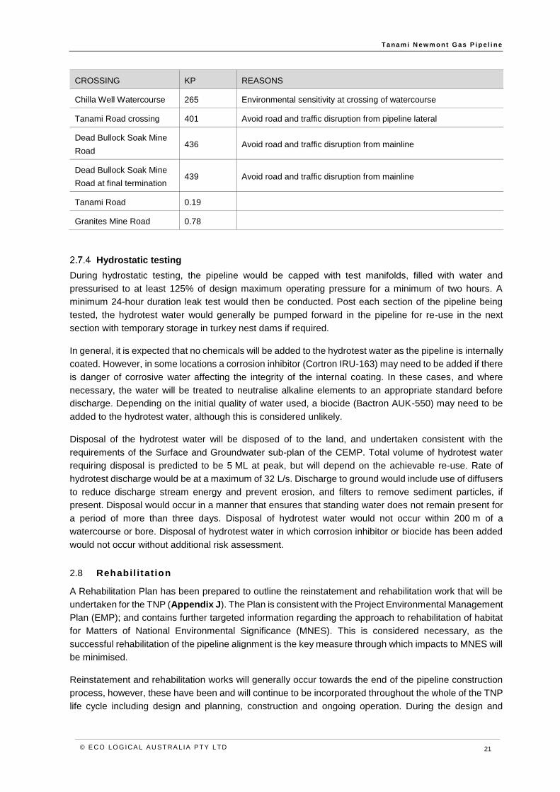
Hydrostatic testing
During hydrostatic testing, the pipeline would be capped with test manifolds, filled with water and
pressurised to at least 125% of design maximum operating pressure for a minimum of two hours. A
minimum 24-hour duration leak test would then be conducted. Post each section of the pipeline being
tested, the hydrotest water would generally be pumped forward in the pipeline for re-use in the next
section with temporary storage in turkey nest dams if required.
In general, it is expected that no chemicals will be added to the hydrotest water as the pipeline is internally
coated. However, in some locations a corrosion inhibitor (Cortron IRU-163) may need to be added if there
is danger of corrosive water affecting the integrity of the internal coating. In these cases, and where
necessary, the water will be treated to neutralise alkaline elements to an appropriate standard before
discharge. Depending on the initial quality of water used, a biocide (Bactron AUK-550) may need to be
added to the hydrotest water, although this is considered unlikely.
Disposal of the hydrotest water will be disposed of to the land, and undertaken consistent with the
requirements of the Surface and Groundwater sub-plan of the CEMP. Total volume of hydrotest water
requiring disposal is predicted to be 5 ML at peak, but will depend on the achievable re-use. Rate of
hydrotest discharge would be at a maximum of 32 L/s. Discharge to ground would include use of diffusers
to reduce discharge stream energy and prevent erosion, and filters to remove sediment particles, if
present. Disposal would occur in a manner that ensures that standing water does not remain present for
a period of more than three days. Disposal of hydrotest water would not occur within 200 m of a
watercourse or bore. Disposal of hydrotest water in which corrosion inhibitor or biocide has been added
would not occur without additional risk assessment.
2.8 Rehabil itat ion
A Rehabilitation Plan has been prepared to outline the reinstatement and rehabilitation work that will be
undertaken for the TNP (Appendix J). The Plan is consistent with the Project Environmental Management
Plan (EMP); and contains further targeted information regarding the approach to rehabilitation of habitat
for Matters of National Environmental Significance (MNES). This is considered necessary, as the
successful rehabilitation of the pipeline alignment is the key measure through which impacts to MNES will
be minimised.
Reinstatement and rehabilitation works will generally occur towards the end of the pipeline construction
process, however, these have been and will continue to be incorporated throughout the whole of the TNP
life cycle including design and planning, construction and ongoing operation. During the design and

T a na m i N e wm o n t G as P i p e l i n e
© E CO LO G ICA L A U S T RA L IA P T Y LT D 22
planning phases, ecological surveys are undertaken to facilitate determination of the vegetation and fauna
habitats that occur and any specific features that are relevant. A range of construction methods and
management measures contribute to the successful rehabilitation of the pipeline corridor, and these are
detailed in the overall project EMP and will also be summarised in the Rehabilitation Plan.
The proposed approach to rehabilitation in addressing impacts to MNES is to base the rehabilitation
requirements on a range of zones. Each zone is intended to account for different MNES habitats (or lack
thereof) and to design rehabilitation actions, completion criteria and contingencies accordingly. A range
of preliminary rehabilitation zones have been defined and are presented in Table 2-5.
These rehabilitation zones have been defined based on ecological survey work undertaken to date,
however, the zones will be refined following further detailed pre-clearance surveys and results of fauna
monitoring during construction. The Rehabilitation Plan is adaptive such that where species are
considered unlikely to occur, based on this further supplementary information, management actions and
completion criteria for that species will no longer be considered relevant and therefore will not be
implemented. Conversely, should MNES be found to occur in areas where they were not predicted, the
management actions and completion criteria for the relevant MNES would then apply and be
implemented.
Table 2-5 Rehabilitation zones
REHABILITATION ZONE
ZONE DESCRIPTION
Native vegetation Defined as all native vegetation within the Project Area, excluding native vegetation
mapped as MNES habitat zones below. Native vegetation has been defined and mapped
as vegetation communities by Mattiske (2017).
Dwarf Desert Spike-
rush habitat
Due to access restrictions during the flora and vegetation survey, potential suitable
habitat for the Dwarf Desert Spike-rush within the Project Area could not be defined
(Mattiske 2017). For the purposes of this Rehabilitation Plan, preliminary Dwarf Desert
Spike-rush habitat zones have been mapped as watercourses known to occur in the
Project Area.
Greater Bilby and
Great Desert Skink
habitat
Preliminary mapping includes Eucalyptus/Corymbia/Acacia woodlands over Triodia
hummocks, and Melaleuca and Acacia shrublands over Triodia hummocks, on
sandplains and paleodrainage channels and in proximity to recent records in the north
and the south of the Project Area.
Night Parrot habitat Preliminary mapping includes Triodia dominated grasslands and Astrebla dominated
shrubby samphire and chenopod associations with scattered trees and shrubs within the
Project Area.
Princess Parrot
habitat
Preliminary mapping includes sandplain woodlands and shrublands, dominated by
scattered Eucalyptus, Casuarina or Allocasuarina, with an understorey of Acacia,
Eremophila, Grevillea, Hakea, Senna and ground cover of Triodia; and riparian areas
dominated by large Eucalyptus or Allocasuarina within the Project Area.
Rehabilitation completion criteria have been designed for each of the above rehabilitation zones in order
to meet the objectives of the Rehabilitation Plan. Completion criteria address a suite of metrics including:
• Native flora species density (plants per m2)

T a na m i N e wm o n t G as P i p e l i n e
© E CO LO G ICA L A U S T RA L IA P T Y LT D 23
• Native flora species richness (per plot)
• Native flora species foliage cover (%)
• Weed foliage cover (%)
It is intended that the completion criteria in the native vegetation zone (i.e. areas without MNES habitat)
would deliver native flora metrics equal to or greater than 40% of that of the adjacent control area. In
MNES zones, the requirements are greater and completion criteria are expected to deliver native flora
metrics equal to or greater than 50% or 60% of that of the adjacent control area and ensure the relevant
MNES’ ecological requirements.
A Project-specific monitoring protocol has been developed to facilitate assessment against the completion
criteria. Additionally, specific management actions have been identified to assist in achieving the
objectives and completion criteria. After the completion criteria have been met, ongoing future
management will comprise maintenance works such as weed control.
There are some factors beyond the control of AGIT that could affect the achievement of rehabilitation
outcomes. These include climate change, occurrence of rainfall (drought or flooding) and fire. It will be
endeavoured to achieve the completion criteria, in spite of these potential occurrences.
Rehabilitation activities will be monitored via a Site Closure Inspection at the completion of construction,
and annually post-construction until the rehabilitated areas have regenerated to meet completion criteria.
If monitoring indicates that objectives and completion criteria for rehabilitation are not being achieved, or
are unlikely to be achieved within two to five years, specific contingencies and corrective actions will be
enacted. If contingency and corrective actions still fail to meet the requirements of the completion criteria,
an alternative course of action will be devised that is jointly agreed upon by all relevant stakeholders (e.g.
AGIT, DoEE and DPIR).
AGIT will ultimately be responsible for the successful rehabilitation of the construction RoW to meet the
specific completion criteria, even though components of this work may be undertaken by contactors. AGIT
(as DBP / DDG) has a proven track record of rehabilitation success in arid environments, including the
Dampier Bunbury Natural Gas Pipeline (DBNGP) Stage 5 Looping Expansion Project, Western Australia
which commenced in 2007. A review of the DBNGP rehabilitation program in 2012 demonstrated that
native species density greater than or equal to that of control sites and temporary impacts on
watercourses were fully rehabilitated (Strategen 2012). Similar success is expected for rehabilitation of
the TNP Project.
At 24 months after construction, if rehabilitation has failed to meet the identified completion criteria,
contingencies and corrective measures will be identified in consultation with the relevant agencies, and
implemented. Details of monitoring are described fully in the Rehabilitation Plan.
2.9 Pipeline commissioning and operat ion
Commissioning of the pipeline would involve:
• Instrument checking to ensure correct calibration.
• Performance testing to ensure all valves and equipment operate to design specifications.
• Introduction of nitrogen blanket and purging of air from the pipeline before gas is introduced.
There will minor venting of gas/nitrogen mix until 100% of gas is achieved.
A commissioning team of approximately four would coordinate and undertake the above activities and at
completion, hand over responsibility to the pipeline operator. Commissioning is expected to take three

T a na m i N e wm o n t G as P i p e l i n e
© E CO LO G ICA L A U S T RA L IA P T Y LT D 24
weeks, and ‘first gas’ is expected to be delivered to the Granites and Dead Bullock Soak mines by March
2019.
The Project would transport gas from the tie-in with the Amadeus Gas Pipeline to power stations at the
Granites and Dead Bullock Soak mines. The pipeline and permanent above ground facilities would be
operated and maintained in accordance with the Australian Standard and industry guidelines.
All permanent above ground facilities will be unmanned. Operation and gas supply of the pipeline and
associated above ground facilities would be remotely controlled from a Control Centre in Perth. Field
support and specialist services based in Perth would support the Project on a fly in fly out basis, with local
employment and service providers used for routine tasks in the field.
Maintenance crews would undertake external inspection of the pipeline at regular intervals. The asset
management and maintenance requirements are prescribed in the Australian Standard 2885.
Greenhouse gas and other atmospheric emissions (Co(x), NO(x), SO(x) and hydrocarbons) will arise from
planned venting activities, fugitive losses, and maintenance requirements.
No waste generation and water use would occur during the operational phase.
Solar power would be utilised at the Tanami meter station and mainline scraper stations. Power to the
meter stations would be provided from the respective mines.
2.10 Pipeline decommissioning
The Tanami Newmont Gas Pipeline will be designed with an operational life of 20 years and will be
designed fit for purpose. With an approved AMP, EMP and PMP, the Project will be resourced for opex
and capex and operated in accordance with its Licence obligations, the pipeline and associated facilities
are expected to have an operational life that can be matched to gas supply availability and consumer
demand.
When supply and demand of gas is exhausted. Areas disturbed as part of the permanent footprint will be
rehabilitated and the pipeline decommissioned consistent with the requirements of legislation, Australian
Standards and industry practices at the time. At the appropriate time, a detailed decommissioning plan
will be prepared to guide these activities, in conjunction with the Rehabilitation Plan.

T a na m i N e wm o n t G as P i p e l i n e
© E CO LO G ICA L A U S T RA L IA P T Y LT D 25
3 Risk assessment and identification of potential impacts
A comprehensive risk assessment has been undertaken to inform the impact assessment process. The
risk assessment identified all Project related activities which may impact threatened species, the likelihood
and consequences of such impacts, inherent risk pre-mitigation and the residual risk following the
application of management measures, for both construction and operational phases of the Project.
Avoidance, prevention and management measures and residual risk are identified in Section 7 to Section
11, inclusive. Potential impacts that had residual risk levels of intermediate to extreme were the primary
focus of the impact assessment.
Definitions for likelihood, consequence and risk ratings are provided in Table 3-1 to Table 3-4 below.
Table 3-1 Definitions of likelihood
LIKELIHOOD/PROBABILITY
A Almost certain Common repeating occurrence that is ongoing
Is expected to occur with pipeline developments of this scale
B Likely Will probably occur at some time and in most circumstances
Known to occur with pipeline developments
C Possible Could occur at some time but not often
Sometimes occurs with pipeline developments
D Unlikely Could potentially occur at some time
Uncommonly occurs in pipeline developments
E Rare Practically impossible
Will only occur in very rare circumstances
Not known to occur in pipeline developments
Table 3-2 Consequence ratings and definitions for terrestrial fauna
1 2 3 4 5
TRIVIAL MINOR SEVERE MAJOR CATASTROPHIC
No loss of threatened species habitat
Minor local habitat modification1 and/or lifecycle disruption2 for a threatened species
Minor local loss of threatened species habitat
Moderate local habitat modification1 and/or lifecycle disruption2 for a threatened species
Moderate local loss of threatened species habitat
Substantial local habitat modification1 and/or lifecycle disruption2 for a threatened species
Substantial local loss of threatened species habitat
Moderate regional habitat modification1 and/or lifecycle disruption2 for a threatened species
Moderate or substantial regional loss of threatened species habitat
Substantial regional habitat modification1 and/or lifecycle disruption2 for a threatened species
No loss of individuals of threatened fauna species
Minor local decrease in size of population(s) of threatened fauna species
Moderate local decrease in size of population(s) of threatened fauna species
Substantial local decrease in size of population(s) of threatened fauna species
Moderate or substantial regional decrease in size of population(s) of threatened fauna species
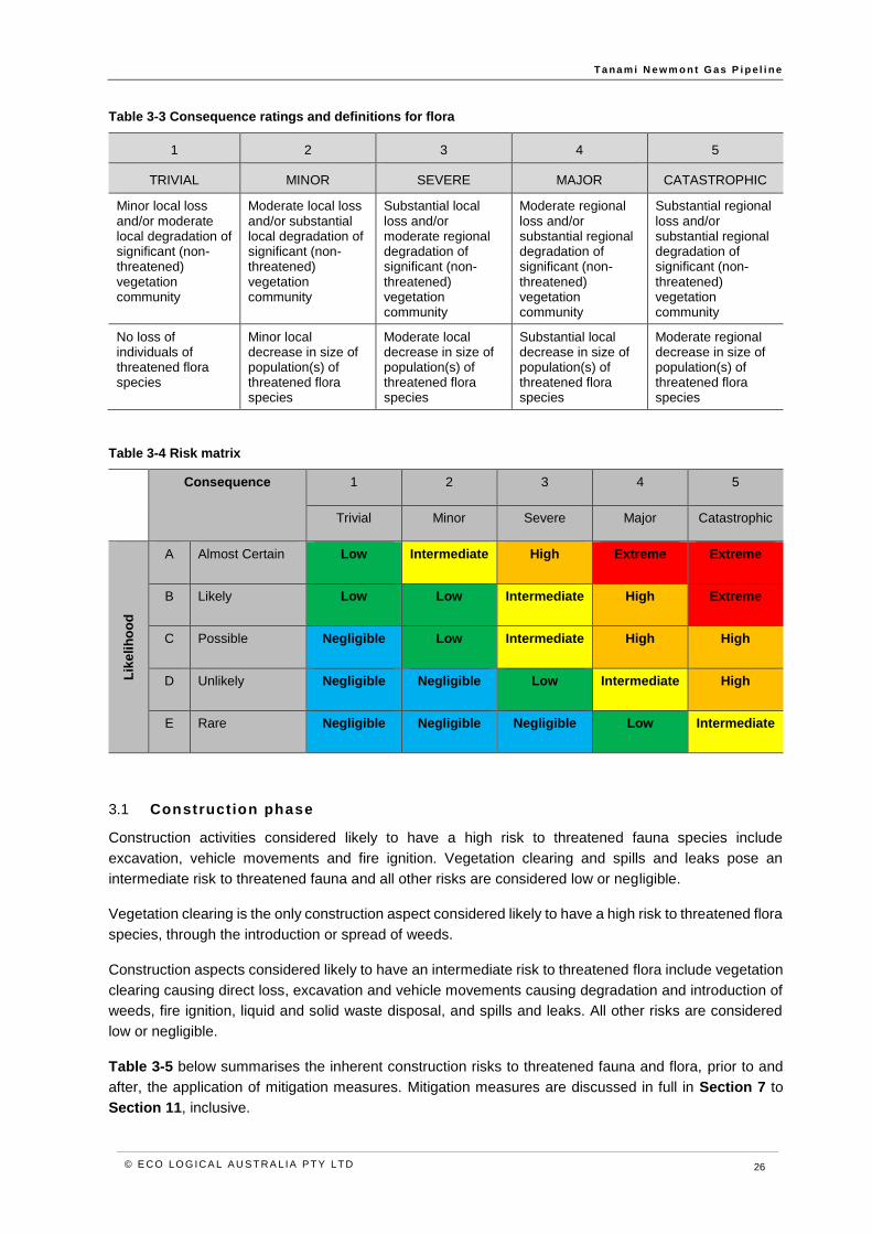
T a na m i N e wm o n t G as P i p e l i n e
© E CO LO G ICA L A U S T RA L IA P T Y LT D 26
Table 3-3 Consequence ratings and definitions for flora
1 2 3 4 5
TRIVIAL MINOR SEVERE MAJOR CATASTROPHIC
Minor local loss and/or moderate local degradation of significant (non-threatened) vegetation community
Moderate local loss and/or substantial local degradation of significant (non-threatened) vegetation community
Substantial local loss and/or moderate regional degradation of significant (non-threatened) vegetation community
Moderate regional loss and/or substantial regional degradation of significant (non-threatened) vegetation community
Substantial regional loss and/or substantial regional degradation of significant (non-threatened) vegetation community
No loss of individuals of threatened flora species
Minor local decrease in size of population(s) of threatened flora species
Moderate local decrease in size of population(s) of threatened flora species
Substantial local decrease in size of population(s) of threatened flora species
Moderate regional decrease in size of population(s) of threatened flora species
Table 3-4 Risk matrix
Consequence 1 2 3 4 5
Trivial Minor Severe Major Catastrophic
Lik
eli
ho
od
A Almost Certain Low Intermediate High Extreme Extreme
B Likely Low Low Intermediate High Extreme
C Possible Negligible Low Intermediate High High
D Unlikely Negligible Negligible Low Intermediate High
E Rare Negligible Negligible Negligible Low Intermediate
3.1 Construction phase
Construction activities considered likely to have a high risk to threatened fauna species include
excavation, vehicle movements and fire ignition. Vegetation clearing and spills and leaks pose an
intermediate risk to threatened fauna and all other risks are considered low or negligible.
Vegetation clearing is the only construction aspect considered likely to have a high risk to threatened flora
species, through the introduction or spread of weeds.
Construction aspects considered likely to have an intermediate risk to threatened flora include vegetation
clearing causing direct loss, excavation and vehicle movements causing degradation and introduction of
weeds, fire ignition, liquid and solid waste disposal, and spills and leaks. All other risks are considered
low or negligible.
Table 3-5 below summarises the inherent construction risks to threatened fauna and flora, prior to and
after, the application of mitigation measures. Mitigation measures are discussed in full in Section 7 to
Section 11, inclusive.

T a na m i N e wm o n t G as P i p e l i n e
© E CO LO G ICA L A U S T RA L IA P T Y LT D 27
3.2 Operational phase
No operational aspects are expected to pose a high risk to threatened fauna. Vehicle movements causing
degradation of habitat through introduction or spread of weeds, pose an intermediate risk to threatened
fauna. Other risks are considered low.
No operational aspects are expected to pose a high risk to threatened flora.
The physical presence of infrastructure and vehicle movements, causing introduction and spread of
weeds and vegetation degradation are considered likely to pose an intermediate risk to threatened flora.
Table 3-6Table 3-5 below summarises the inherent operational risks to threatened fauna and flora
species.
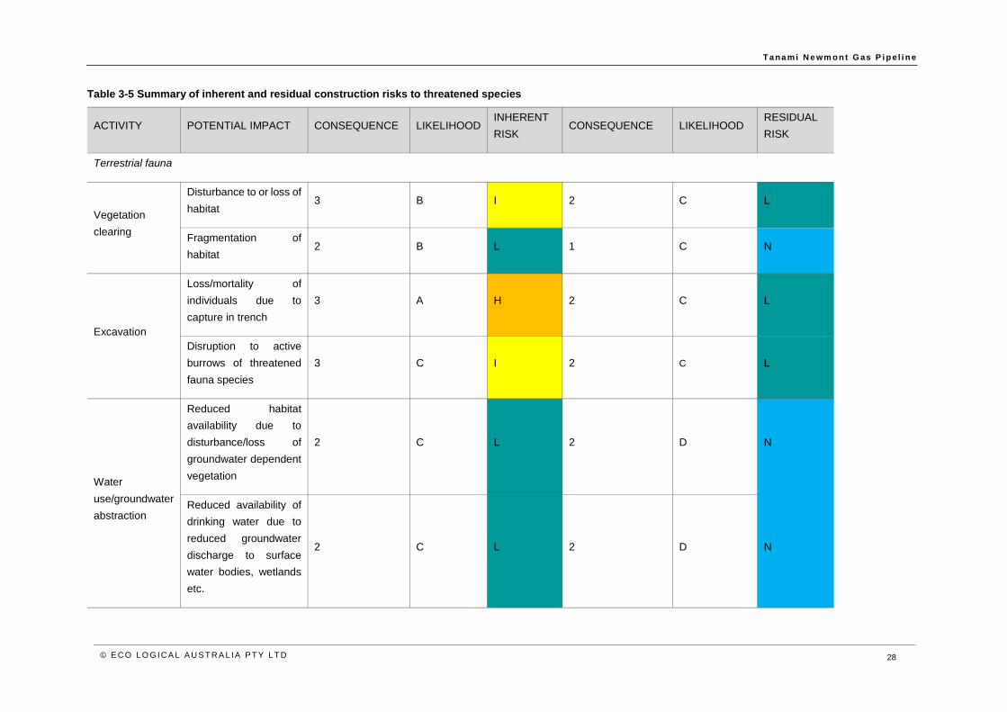
T a na m i N e wm o n t G as P i p e l i n e
© E CO LO G ICA L A U S T RA L IA P T Y LT D 28
Table 3-5 Summary of inherent and residual construction risks to threatened species
ACTIVITY POTENTIAL IMPACT CONSEQUENCE LIKELIHOOD INHERENT
RISK CONSEQUENCE LIKELIHOOD
RESIDUAL
RISK
Terrestrial fauna
Vegetation
clearing
Disturbance to or loss of
habitat 3 B I 2 C L
Fragmentation of
habitat 2 B L 1 C N
Excavation
Loss/mortality of
individuals due to
capture in trench
3 A H 2 C L
Disruption to active
burrows of threatened
fauna species
3 C I 2 C L
Water
use/groundwater
abstraction
Reduced habitat
availability due to
disturbance/loss of
groundwater dependent
vegetation
2 C L 2 D N
Reduced availability of
drinking water due to
reduced groundwater
discharge to surface
water bodies, wetlands
etc.
2 C L 2 D N
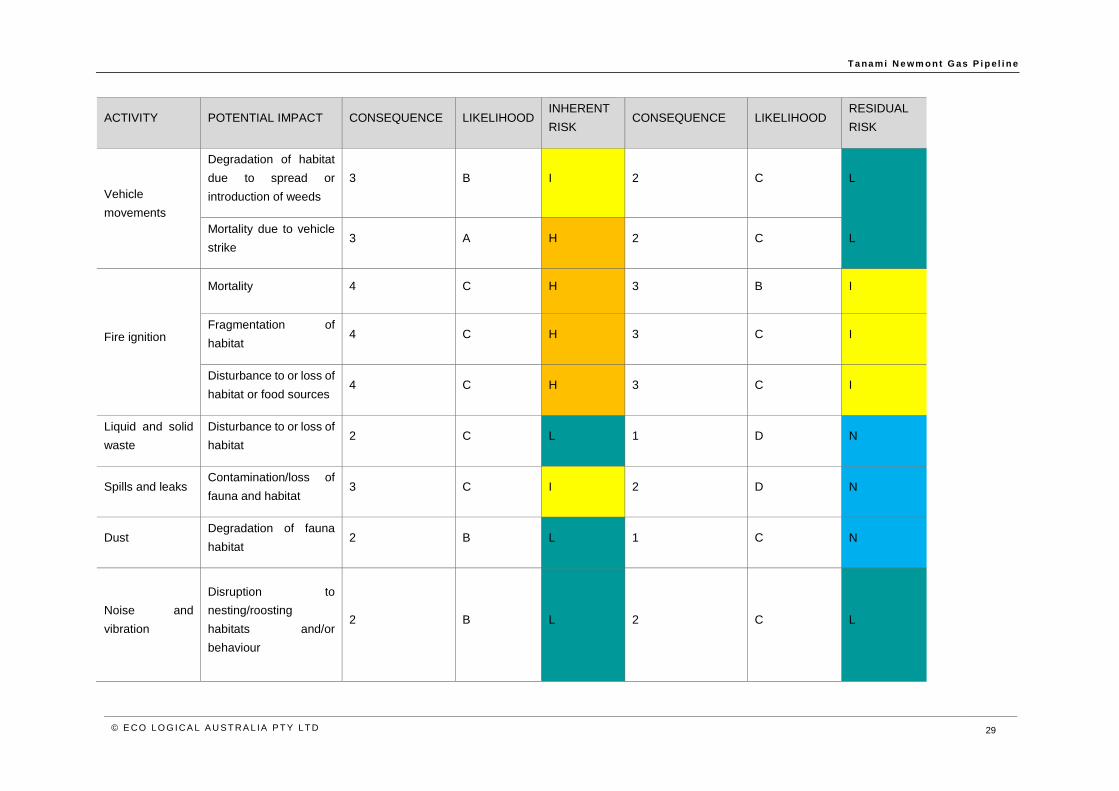
T a na m i N e wm o n t G as P i p e l i n e
© E CO LO G ICA L A U S T RA L IA P T Y LT D 29
ACTIVITY POTENTIAL IMPACT CONSEQUENCE LIKELIHOOD INHERENT
RISK CONSEQUENCE LIKELIHOOD
RESIDUAL
RISK
Vehicle
movements
Degradation of habitat
due to spread or
introduction of weeds
3 B I 2 C L
Mortality due to vehicle
strike 3 A H 2 C L
Fire ignition
Mortality 4 C H 3 B I
Fragmentation of
habitat 4 C H 3 C I
Disturbance to or loss of
habitat or food sources 4 C H 3 C I
Liquid and solid
waste
Disturbance to or loss of
habitat 2 C L 1 D N
Spills and leaks Contamination/loss of
fauna and habitat 3 C I 2 D N
Dust Degradation of fauna
habitat 2 B L 1 C N
Noise and
vibration
Disruption to
nesting/roosting
habitats and/or
behaviour
2 B L 2 C L

T a na m i N e wm o n t G as P i p e l i n e
© E CO LO G ICA L A U S T RA L IA P T Y LT D 30
ACTIVITY POTENTIAL IMPACT CONSEQUENCE LIKELIHOOD INHERENT
RISK CONSEQUENCE LIKELIHOOD
RESIDUAL
RISK
Flora and vegetation
Vegetation
clearing
Disturbance to or loss of
threatened flora 3 C I 2 C L
Degradation of
vegetation community
due to introduction or
spread of weeds
3 A H 2 C L
Excavation
Degradation of
vegetation community
due to spread of weeds
3 B I 2 C L
Water
use/groundwater
abstraction
Disturbance to or loss or
groundwater dependent
vegetation
2 C L 2 D N
Vehicle
movements
Degradation of
vegetation due to
introduction or spread of
weeds
3 B I 2 C L
Fire ignition
Disturbance to or loss of
threatened flora 3 B I 2 C L
Degradation of
vegetation due to
sedimentation or
physical modification of
watercourse from fire
2 D N 1 D N
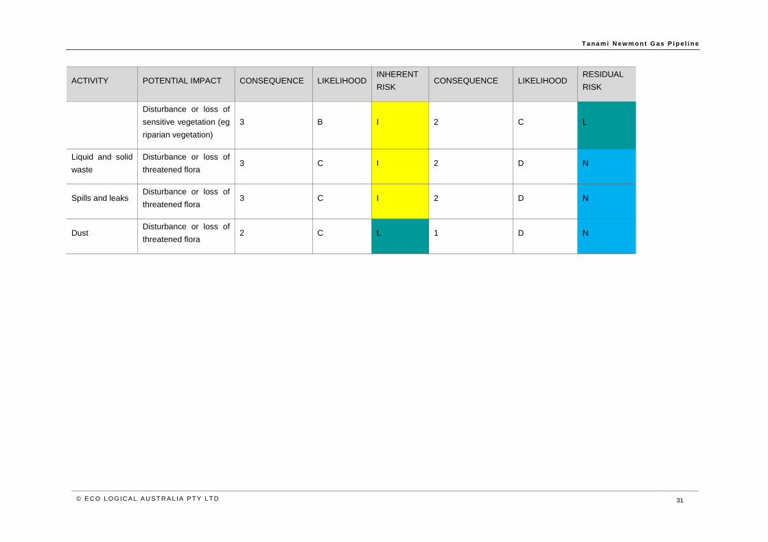
T a na m i N e wm o n t G as P i p e l i n e
© E CO LO G ICA L A U S T RA L IA P T Y LT D 31
ACTIVITY POTENTIAL IMPACT CONSEQUENCE LIKELIHOOD INHERENT
RISK CONSEQUENCE LIKELIHOOD
RESIDUAL
RISK
Disturbance or loss of
sensitive vegetation (eg
riparian vegetation)
3 B I 2 C L
Liquid and solid
waste
Disturbance or loss of
threatened flora 3 C I 2 D N
Spills and leaks Disturbance or loss of
threatened flora 3 C I 2 D N
Dust Disturbance or loss of
threatened flora 2 C L 1 D N
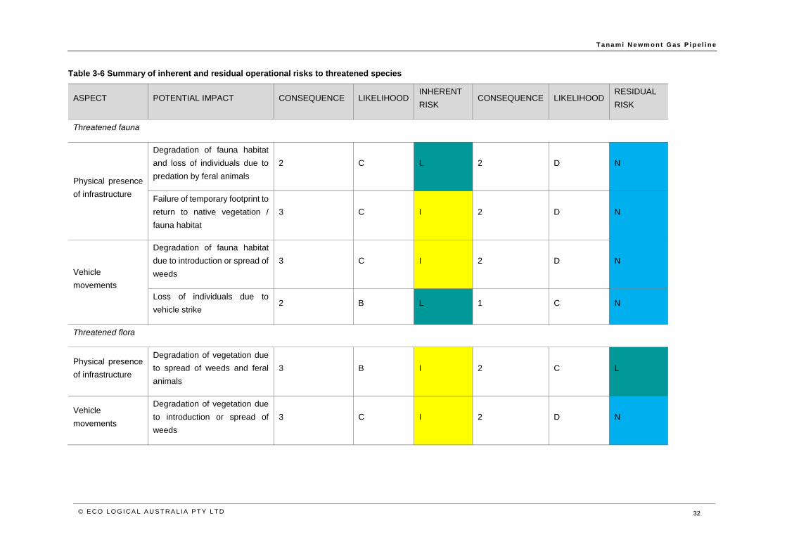
T a na m i N e wm o n t G as P i p e l i n e
© E CO LO G ICA L A U S T RA L IA P T Y LT D 32
Table 3-6 Summary of inherent and residual operational risks to threatened species
ASPECT POTENTIAL IMPACT CONSEQUENCE LIKELIHOOD INHERENT
RISK CONSEQUENCE LIKELIHOOD
RESIDUAL
RISK
Threatened fauna
Physical presence
of infrastructure
Degradation of fauna habitat
and loss of individuals due to
predation by feral animals
2 C L 2 D N
Failure of temporary footprint to
return to native vegetation /
fauna habitat
3 C I 2 D N
Vehicle
movements
Degradation of fauna habitat
due to introduction or spread of
weeds
3 C I 2 D N
Loss of individuals due to
vehicle strike 2 B L 1 C N
Threatened flora
Physical presence
of infrastructure
Degradation of vegetation due
to spread of weeds and feral
animals
3 B I 2 C L
Vehicle
movements
Degradation of vegetation due
to introduction or spread of
weeds
3 C I 2 D N
T a na m i N e wm o n t G as P i p e l i n e
© E CO LO G ICA L A U S T RA L IA P T Y LT D 33
4 Environmental management for the Project
4.1 Environmental Management System
AGIT commits to excellence in environmental performance and will manage potential impacts to MNES
through implementation of an EMP, as part of an overarching Risk Management System, compliant with
ISO14001. In doing so, AGIT adopts all DBP policies procedures across the operation of its business.
DBP has a corporate culture which strives for Health, Safety and Environment (HSE) excellence driven
by a corporate commitment to protect people and the environment. This is supported by a statement of
commitment signed by the DBP Executive Team, and a set of core principles, called Zero Harm Principles
which are aimed at establishing principles for undertaking activities that have been assessed as having
the highest risk to DBP and its workforce.
A copy of the AGIG Health, Safety and Environmental Policy’s and Statement of Commitment is provided
in Appendix E.
The DBP HSE Policy is reviewed annually, or when there is a significant change to the organisation or its
activities, to ensure that the policy remains comprehensive and current. Employees are consulted during
the review process through a number of mechanisms including HSE Committees.
AGIT will hold overall responsibility for environmental management and ensure adequate resources are
provided for the implementation of the EMP. All staff are responsible for the environmental performance
of their activities and for reporting any environmental hazards and incidents. Environmental
responsibilities for staff are contained within position descriptions, relevant procedures and work
instructions. Overarching environmental roles are described in the EMP (Appendix H).
AGIT also intends to engage a Construction Contractor (Constructor) to build the Project and individual
contractors will be engaged for specific components of the build. Ensuring that the contractors understand
and adhere to the environmental controls established for the Project will be critical to achieving the
performance objectives and targets established in the EMP. AGIT will achieve this by:
• Clearly identifying the respective responsibilities of AGIT and the Constructor for the controls
within each sub-plan included in the EMP.
• Requiring, reviewing and approving the Constructor's CEMP to ensure that the controls
implemented by the Constructor through the CEMP are consistent with and support the
overarching EMP for the Project.
• Ensuring clear line responsibility and supervision between AGIT and the Constructor.
• Clearly identifying the environmental responsibilities for AGIT staff and the Constructor within
position descriptions, relevant procedures and work instructions.
• Requiring the Constructor to conduct regular inspections and record keeping against
compliance with the EMP, coupled with AGIT auditing of these arrangements.
The delineation of environmental responsibilities is described fully in the EMP.
4.2 Environmental Management Plan for the Project
AGIT has developed a comprehensive avoidance and mitigation strategy, supported by an EMP,
prepared as a component of the Pipeline Management Plan required to fulfil the requirements of the
Consent to Construct and Consent to Operate under the Energy Pipelines Regulations, and as a
reference for other statutory approvals requiring a consolidated plan for the environmental management

T a na m i N e wm o n t G as P i p e l i n e
© E CO LO G ICA L A U S T RA L IA P T Y LT D 34
of the Project. AGIT is also willing to consider further mitigation measures, in consultation with the
Commonwealth Government.
Implementation of the EMP will ensure AGIT meets its obligations including legislation, regulations and
conditions of approval.
The EMP aims to establish suitable controls to eliminate or minimise the risks to the environment to a
level that is low, negligible or reduced to as low as reasonably practicable. The EMP further seeks to
provide a framework for measuring environmental performance against legislative requirements and
company policies and standards.
To achieve these overarching objectives, the EMP specifically aims to:
• Inform AGIT staff and contractors of their environmental obligations.
• Provide site-specific environmental control procedures.
• Provide rational and practical environmental guidelines for the construction of the Project, to
ensure construction activities do not adversely affect environmental values.
• Ensure that any potential environmental impacts arising from the construction of the Project,
are managed in accordance with legislative requirements.
• Develop environmental guidelines for conducting staff induction and training.
An abridged version of the EMP is attached (Appendix H) and should be read in conjunction with other
key management documents including:
• Trench Clearing Procedure
• DBP Emergency Response Plan.
• DBP Crisis Management Plan.
• TNP Safety Case.
T a na m i N e wm o n t G as P i p e l i n e
© E CO LO G ICA L A U S T RA L IA P T Y LT D 35
5 Understanding MNES in the Project area
A number of desktop and field studies have been conducted to assess environmental values in the Project
area, including fauna and flora surveys. These include the following:
• Tanami Gas Pipeline FEED Project Definition Report (WorleyParsons 2016)
• Tanami Gas Pipeline Terrestrial Ecology Desktop Assessment (Mattiske 2017a)
• Flora and Vegetation Assessment of the Tanami Gas Pipeline Project Area, Northern
Territory (Mattiske 2017b)
• Reconnaissance fauna survey of the proposed Tanami Gas Pipeline, Northern Territory
(BIOSTAT 2017)
• Telstra Tanami Cable Fauna Desktop Risk Assessment (Low Ecological 2016)
• Twin Bonanza Dry Season Flora and Fauna Survey (EcOz Environmental 2013).
These findings are summarised below.
5.1 Desktop studies
Two desktop studies were undertaken of the Project area including a Project Definition Report
(WorleyParsons 2016). This report investigated options and developed a feasible scope of work, design
basis and cost estimate for the pipeline and associated facilities, with the key objective of determining the
most cost-effective solution to meet technical, safety, regulatory and environmental requirements.
A subsequent desktop flora and fauna assessment (Mattiske 2017a) was undertaken to identify key
ecological values with the potential to be impacted by the Project and to identify gaps in information and
to provide recommendations regarding further work.
Combined, these two studies were used to develop scopes of field work to further assess flora and
vegetation and fauna values in the Project area. These field studies are outlined below.
5.2 Field assessments
Flora and vegetation
A flora and vegetation survey of the Project area was undertaken in August 2017 (Mattiske 2017b;
Appendix G) including both desktop assessment and field survey. The desktop assessment included a
review of the EPBC Protected Matters Search Tool database, the NT Natural Resource Management
InfoNet database, the Atlas of Living Australia, NT Department of Land Resource Management Natural
Resourcing Mapping portal and other ecological studies in the vicinity.
The findings of the desktop assessment were used to inform the field survey, which was undertaken by
four experienced botanists between 14th and 22nd August 2017 in accordance with Northern Territory
Guidelines and Field Methodology for Vegetation Survey and Mapping (Brocklehurst et al. 2007). Permit
conditions stipulated by the Central Land Council meant that some areas within the Project area could
not be surveyed and these exclusion areas included minor and major creeklines, with the exception of
Napperby Creek, and elevated rocky areas (Mattiske 2017b). Other potential limitations of the study relate
to above average rainfall in the wet season of 2016/2017 may have influenced survey findings; however,
the subsequent four month dry period, preceding the survey likely reduced the number of species present.
This was not considered a limitation as the definition of vegetation communities at the level required relies
on identification of perennial species.

T a na m i N e wm o n t G as P i p e l i n e
© E CO LO G ICA L A U S T RA L IA P T Y LT D 36
Fire scars and grazing may limit the accuracy of vegetation community delineation; however, interfaces
between communities should be treated as gradual rather than abrupt transitions and grazing pressure
did not significantly impact vegetation delineation.
The survey assessed 91 survey sites across the 440 km pipeline alignment, selected based upon aerial
photographic maps and field observations. Survey sites comprised 20 m by 20 m quadrats in addition to
unconfined releve sites. This combination of survey methodologies and both number and selectin of
survey sites was considered appropriate given the scale and remoteness of the Project area.
Flora and vegetation were sampled systematically at each site, vegetation condition assessed and
opportunistic collections made. Flora and vegetation were described and sampled systematically at each
site and additional opportunistic collections were made wherever previously unrecorded plants were
observed. At each quadrat, records were made of GPS location, topography, soil type and colour,
outcropping rocks and type, percentage litter cover and bare ground, approximate time since fire,
vegetation condition and vascular plant height and percentage cover.
The survey also identified two flora species listed as threatened under the EPBC Act were identified
during the desktop assessment including the following:
• Dwarf Desert Spike-rush (Eleocharis papillosa) – Vulnerable.
• MacDonnell Ranges Cycad (Macrozamia macdonnellii) – Vulnerable.
The field survey recorded 31 vegetation communities in the Project area, none of which are considered
to be locally restricted and 254 plant species, none of which are listed as threatened under the EPBC Act.
No flora listed as threatened under the EPBC Act were recorded in the Project area during the field survey.
Introduced weeds
The desktop component of the flora and vegetation survey identified 25 weed species as potentially
occurring in the Project area, including three Weeds of National Significance (WONS). Nine of the 25
species are listed as Declared weeds in the Northern Territory.
The field survey recorded four introduced weed species (Mattiske 2017b) including the following:
• Buffel Grass (Cenchrus ciliaris).
• Couch grass (Cynodon dactylon).
• Spiked Malvastrum (Malvastrum americanum).
• Mimosa bush (Vachellia farnesiana).
None of these species are WONS or listed as Declared pests under the Weeds Act (NT).
Buffel Grass is listed as a significant threat in the Alice Springs Regional Weed Management Plan (DLRM
2013) and is the most prevalent weed species in the Project area (BIOSTAT 2017), dominating ground
cover between Yuendumu and the southern limit of the Project area. It coincided with impacts from
introduced herbivores and has overtaken native spinifex grasslands and forms large dense tussocks.
Spiked Malvastrum also occurs in southern portion of the Project area. Couch grass and Mimosa bush
are established on the banks of the Napperby Creek, on depositional sands and flood out areas
associated with the creekline (Mattiske 2017b).
Overall, weed occurrence and percentage cover appears to be associated with cattle movement and
grazing.

T a na m i N e wm o n t G as P i p e l i n e
© E CO LO G ICA L A U S T RA L IA P T Y LT D 37
Terrestrial fauna
A reconnaissance fauna survey (BIOSTAT 2017; Appendix F) was conducted of the Project area in 2017
including a desktop assessment and subsequent field survey, to provide an overview of landscape and
habitat structures across the 440 km pipeline alignment and to assess habitat of significance for
threatened fauna. The survey incorporated the intent of the Guidelines for Assessment of Impacts on
Terrestrial Biodiversity (NT EPA 2013) and the Significant Impact Guidelines (DoE 2013a). These
guidelines are non-prescriptive and refer to available guidance for surveying listed species and defer to
other methods as appropriate.
Given the remoteness of the Project and the long, narrow Project area, and noting access restrictions,
this approach was considered sufficient and the most appropriate to describe the fauna habitats and to
determine likely presence of threatened species. This approach is broad and did not include trapping or
active searches, but is underpinned by the extensive data already available.
Desktop assessment
The desktop assessment included a search of publicly available databases including the NT Fauna Atlas,
Atlas of Living Australia and the EPBC Protected Matters Search Tool. A literature review was conducted
and included peer reviewed articles relevant to the Project area. Combined, the desktop searches
identified 290 fauna species including ten species listed as threatened under the EPBC Act as potentially
occurring in the Project area. These include:
• Red Goshawk (Erythrotriorchis radiatus) – Vulnerable.
• Australian Painted Snipe (Rostratula australis) – Endangered.
• Princess Parrot (Polytelis alexandrae) – Vulnerable.
• Night Parrot (Pezoporus occidentalis) – Endangered.
• Masked Owl (Tyto novaehollandiae kimberli) – Vulnerable.
• Crest-tailed Mulgara (Dasycercus cristicauda) – Vulnerable.
• Greater Bilby (Macrotis lagotis) – Vulnerable.
• MacDonnell Range Rock Wallaby (Petrogale lateralis ssp. (ANWC CM15314)) also known
as MacDonnell Ranges race – Vulnerable.
• Central Rock-rat (Zyzomys pedunculatus) – Endangered.
• Great Desert Skink (Egernia kintorei) – Vulnerable.
Field survey
The desktop assessment indicated that threatened species had previously been recorded in the vicinity
of the Project area and accordingly, these were the focus of the field survey.
The field survey was conducted by two highly experienced zoologists over seven days in August 2017
and described 40 sites which were considered representative of the landscape and habitats present in
the Project area.
The field survey recorded an inventory of vertebrate fauna species observed during the site assessment,
identified species not recorded but likely to occur based on habitats present, included an assessment of
the significance of habitats and an assessment of the potential for threatened species to occur. Habitat
assessments included descriptions of the sites using stratum height, soil texture and aspect. Landscape
descriptions were based on Australian Soil and Land Survey standardised methodology. Habitat mapping
was conducted at a high level and represents habitat mosaics, within which there is a high level of
structural variability.
Limitations of the survey relate to some bias in the distribution of observational data to the north of the
alignment and some restrictions on access to 45 parcels of land covering an approximate linear length of
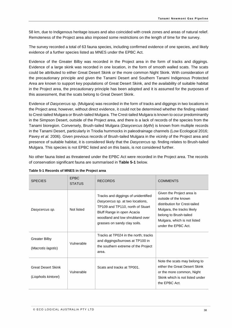
T a na m i N e wm o n t G as P i p e l i n e
© E CO LO G ICA L A U S T RA L IA P T Y LT D 38
58 km, due to Indigenous heritage issues and also coincided with creek zones and areas of natural relief.
Remoteness of the Project area also imposed some restrictions on the length of time for the survey.
The survey recorded a total of 63 fauna species, including confirmed evidence of one species, and likely
evidence of a further species listed as MNES under the EPBC Act.
Evidence of the Greater Bilby was recorded in the Project area in the form of tracks and diggings.
Evidence of a large skink was recorded in one location, in the form of smooth walled scats. The scats
could be attributed to either Great Desert Skink or the more common Night Skink. With consideration of
the precautionary principle and given the Tanami Desert and Southern Tanami Indigenous Protected
Area are known to support key populations of Great Desert Skink, and the availability of suitable habitat
in the Project area, the precautionary principle has been adopted and it is assumed for the purposes of
this assessment, that the scats belong to Great Desert Skink.
Evidence of Dasycercus sp. (Mulgara) was recorded in the form of tracks and diggings in two locations in
the Project area; however, without direct evidence, it could not be determined whether the finding related
to Crest-tailed Mulgara or Brush-tailed Mulgara. The Crest-tailed Mulgara is known to occur predominantly
in the Simpson Desert, outside of the Project area, and there is a lack of records of the species from the
Tanami bioregion. Conversely, Brush-tailed Mulgara (Dasycercus blythi) is known from multiple records
in the Tanami Desert, particularly in Triodia hummocks in paleodrainage channels (Low Ecological 2016;
Pavey et al. 2006). Given previous records of Brush-tailed Mulgara in the vicinity of the Project area and
presence of suitable habitat, it is considered likely that the Dasycercus sp. finding relates to Brush-tailed
Mulgara. This species is not EPBC listed and on this basis, is not considered further.
No other fauna listed as threatened under the EPBC Act were recorded in the Project area. The records
of conservation significant fauna are summarised in Table 5-1 below.
Table 5-1 Records of MNES in the Project area
SPECIES EPBC
STATUS RECORDS COMMENTS
Dasycercus sp. Not listed
Tracks and diggings of unidentified
Dasycercus sp. at two locations,
TP109 and TP110, north of Stuart
Bluff Range in open Acacia
woodland and low shrubland over
grasses on sandy clay soils.
Given the Project area is
outside of the known
distribution for Crest-tailed
Mulgara, the tracks likely
belong to Brush-tailed
Mulgara, which is not listed
under the EPBC Act.
Greater Bilby
(Macrotis lagotis)
Vulnerable
Tracks at TP024 in the north; tracks
and diggings/burrows at TP100 in
the southern extreme of the Project
area.
Great Desert Skink
(Liopholis kintorei)
Vulnerable
Scats and tracks at TP001.
Note the scats may belong to
either the Great Desert Skink
or the more common, Night
Skink which is not listed under
the EPBC Act.
T a na m i N e wm o n t G as P i p e l i n e
© E CO LO G ICA L A U S T RA L IA P T Y LT D 39
Introduced fauna
Evidence of a number of feral fauna species was recorded across all survey sites in the Project area
including dogs, cattle and camels. Scats and tracks of foxes and cats were recorded at most sites. Two
feral horses and two domestic dogs were observed near Yuendumu (BIOSTAT 2017).
Fauna habitats
The fauna survey identified five habitat types in the Project area (BIOSTAT 2017), which are generally
aligned with the Land Systems of the region. These five fauna habitats were defined from the
reconnaissance survey. A number of exclusion zones applied to the survey and included significant
riparian habitats, rocky hills and interzones.
There was high variability in the structure within each fauna habitat and spinifex grasslands are more
diverse than other habitats.
Generally, spinifex grasses form a major component of habitats in the northern section of the Project
area, which occur most commonly over silty clay loams common to the palaeochannel and drainage
plains, but also occur on lateritic sandplain soils.
Spinifex grasslands are impacted by Buffel Grass incursion, which has reduced the quality of habitats
and altered fire regimes.
The five habitat types are identified in Table 5-2 and mapped in Appendix A and Appendix B. It should
be noted that habitat boundaries on the ground are not as distinct as mapped, but rather change from
one dominant type to another in a transition zone, or ecotone.
The five fauna habitat types identified by BIOSTAT (2017) have been associated with the vegetation
communities identified during the flora and vegetation survey of the Project area by Mattiske (2017b),
which occur within those habitat boundaries. The fauna report is provided in Appendix F.
AGIT has undertaken a further innovative assessment of habitats, to better refine the vegetation
communities within each habitat type which are most likely to be the two threatened species recorded or
considered likely to occur in the Project area, based on published habitat information contained in the
EPBC Species Profile and Threats database, conservation advice and recovery plans, and survey
findings, for each species. In particular, this habitat assessment has drawn upon vegetation species
present, soil types, landforms and weed incursion. This more detailed assessment of suitable habitat
types is provided in Section 7 and Section 10.
T a na m i N e wm o n t G as P i p e l i n e
© E CO LO G ICA L A U S T RA L IA P T Y LT D 40
Table 5-2 Fauna habitats recorded in the Project area and value to MNES
FAUNA HABITAT TYPE DESCRIPTION OCCURRENCE IN PROJECT AREA
Riparian/floodplain/clay and
salt pans
Eucalyptus camaldulensis and Eucalyptus victrix and various shrubs in riparian
zone, adjacent to open shrubland and woodland adjacent to
Eucalyptus/Corymbia/Acacia over Buffel Grass or spinifex on orange to red
silty clay loams.
Occurs in the southern end of the Project area,
near the Tilmouth Crossing of Napperby Creek
and floodplain.
Acacia woodlands and
shrublands over tussock
grasses
Acacia open woodlands and shrublands with dense Buffel Grass to dense
woodland with sparse understorey, over sands or deep silty clay soils.
Occurs approximately from the centre of the
Project area to the southern extent, interspersed
with other habitat types.
Eucalyptus/Corymbia/Acacia
woodlands over tussock
grasses
Eucalyptus/Corymbia/Acacia woodland of varying density over predominantly
Buffel Grass, over orange/red compacted sandy clay loams.
This habitat occurs in the southern half of the
Project area., predominantly north of Yuendumu
with small, isolated patches south of Yuendumu.
Eucalyptus/Corymbia/Acacia
woodlands over Spinifex
Eucalyptus/Corymbia/Acacia woodland over hummock grasses dominated by
Triodia pungens or Triodia basedowii with mid-storey shrub layer, over stony
clay loams on stony to rocky rises.
A variant occurs occurs on stony clay loams on stony to rocky rises,
characterised by spinifex hummocks at the base of rocky hills.
The most common habitat type, dominating
habitat in the north and occurring throughout, to
the southern extent of the Project area.
Shrubland over spinifex on
sandplains
Low sparse shrublands of Eremophila sp, Melaleuca sp. and chenopods over
hummock grassland in association with low Termitaria (termite colonies) to 1 m
with occasional very large termitarium over 2.5 m in height.
Occurs in the northern half of the Project area.
T a na m i N e wm o n t G as P i p e l i n e
© E CO LO G ICA L A U S T RA L IA P T Y LT D 41
6 Relevant guidance for MNES
In addition to the requirements of the EPBC Act, the following guidance has been considered in assessing
the significance of potential impacts to MNES which have potential to occur in the Project area:
6.1 Signif icant Impact Guidel ines
The Significant Impact Guidelines (DoE 2013a) provide overarching guidance on determining whether an
action is likely to have a significant impact on a matter protected under the EPBC Act and whether or not
a referral is required for a decision by the Australian Government Minister for the Environment on whether
assessment and approval is required.
MNES protected under the EPBC Act, which are relevant to the Project are restricted to threatened
species.
The Project does not include threatened ecological communities, world heritage properties, national
heritage places, wetlands of international importance, migratory species, Commonwealth marine areas,
or nuclear actions.
The analysis has largely been formulated based on the approach to impact assessment under the EPBC
Act. It brings together an understanding of environmental values and types of potential impacts in order
to analyse the effect on MNES. There are a number of concepts which are commonly applied under the
EPBC Act to assess the significance of impacts to MNES. These are defined in Matters of National
Environmental Significance Significant impact guidelines 1.1 (DoE 2013a). In accordance with these
guidelines, the assessment in this report of listed threatened species is presented within the context of
the following key concepts:
• habitat critical to the survival of a species; and
• an important population (this relates particularly to species listed as Vulnerable under the EPBC Act.
Impacts to species listed as Endangered or Critically Endangered are considered in relation to
‘population’).
The meaning of these two concepts is defined in the text box below.
WHAT IS HABITAT CRITICAL TO THE SURVIVAL OF A SPECIES?
Habitat critical to the survival of a species refers to areas that are necessary:
• for activities such as foraging, breeding, roosting, or dispersal;
• for the long-term maintenance of the species or ecological community (including the maintenance
of species essential to the survival of the species or ecological community, such as pollinators);
• to maintain genetic diversity and long term evolutionary development; or
• for the reintroduction of populations or recovery of the species or ecological community.
Such habitat may be, but is not limited to: habitat identified in a recovery plan for the species or ecological
community as habitat critical for that species or ecological community; and/ or habitat listed on the Register of
Critical Habitat maintained by the Minister under the EPBC Act.

T a na m i N e wm o n t G as P i p e l i n e
© E CO LO G ICA L A U S T RA L IA P T Y LT D 42
WHAT IS AN IMPORTANT POPULATION OF A SPECIES?
An ‘important population’ is a population that is necessary for a species’ long-term survival and recovery. This may
include populations identified as such in recovery plans, and/or that are:
• key source populations either for breeding or dispersal;
• populations that are necessary for maintaining genetic diversity; and/or
• populations that are near the limit of the species range.
Source: DoE 2013.
6.2 Approved Conservation Advice and Recovery Plans
Approved Conservation Advice and Recovery Plans are in place for the MNES known or considered likely
or with potential to occur in the Project area. These guidance documents can identify overall conservation
objectives, critical habitat, important populations, key threats and priority management actions. They are
also relevant to the assessment process as the Minister must consider the content of approved
conservation advices and must not act inconsistently with a recovery plan.
Guidance relevant to the Project is identified in Table 6-1 to Table 6-5 below.
Table 6-1 Great Desert Skink guidance
GUIDANCE OBJECTIVES OR PRIORITIES
Approved Conservation Advice for Liopholis kintorei (Great Desert Skink) (TSSC 2016a)
To increase the extent of suitable habitat for the species and retain
is evolutionary potential across its range through:
• Targeted feral predator management.
• Prescribed burning practices and traditional fire
management.
A recovery plan for the Great Desert Skink (Egernia kintorei)
(McAlpin 2001)
Overarching recovery objectives:
• To maintain or improve the conservation status of the
Great Desert Skink over the next ten years.
• To change fire and feral animal management in three
focus areas of the western deserts to benefit
populations of the Great Desert Skink.
The following actions may negatively impact population viability and
recovery of the species:
• Siting new roads, tracks or infrastructure within 2 km
of known populations.
• Mining activities within 3 km of active burrows.
• Spinifex harvest or other vegetation clearance within
1 km of active burrows.
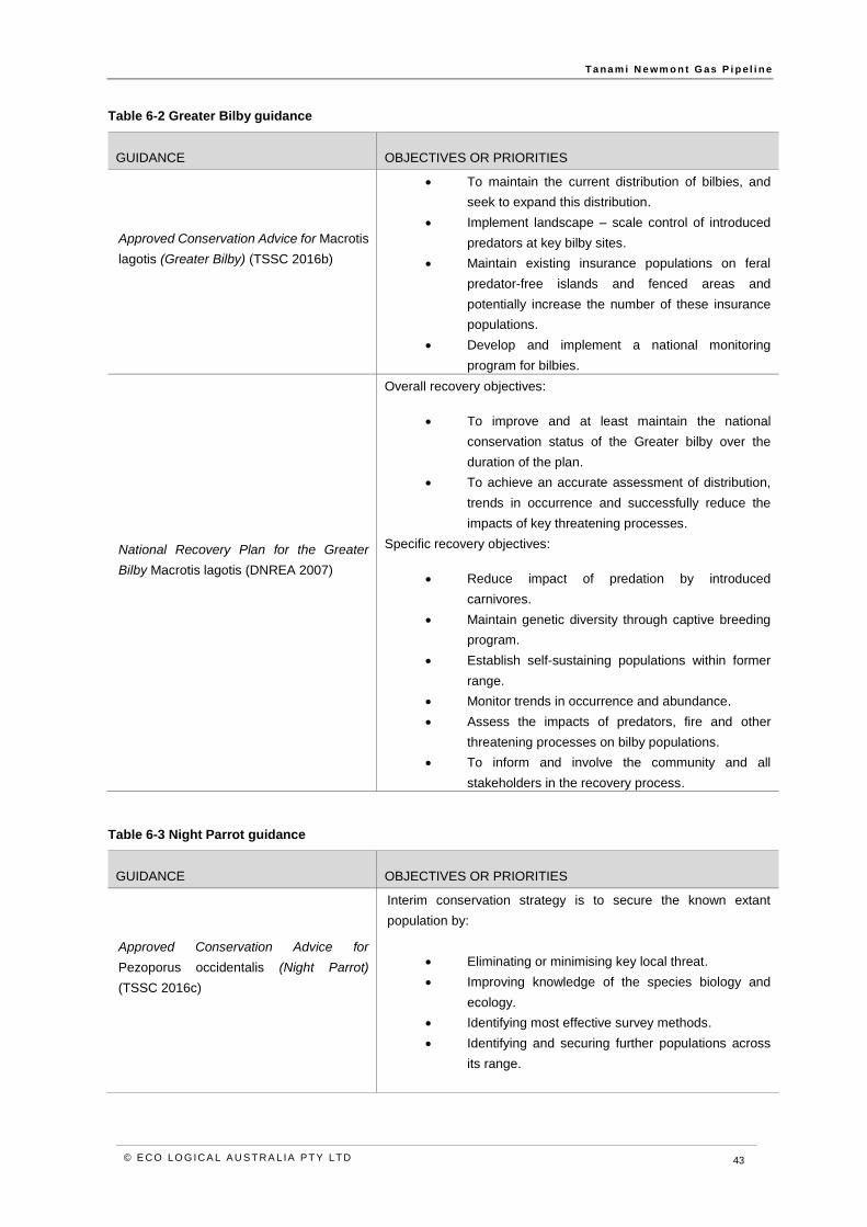
T a na m i N e wm o n t G as P i p e l i n e
© E CO LO G ICA L A U S T RA L IA P T Y LT D 43
Table 6-2 Greater Bilby guidance
GUIDANCE OBJECTIVES OR PRIORITIES
Approved Conservation Advice for Macrotis
lagotis (Greater Bilby) (TSSC 2016b)
• To maintain the current distribution of bilbies, and
seek to expand this distribution.
• Implement landscape – scale control of introduced
predators at key bilby sites.
• Maintain existing insurance populations on feral
predator-free islands and fenced areas and
potentially increase the number of these insurance
populations.
• Develop and implement a national monitoring
program for bilbies.
National Recovery Plan for the Greater
Bilby Macrotis lagotis (DNREA 2007)
Overall recovery objectives:
• To improve and at least maintain the national
conservation status of the Greater bilby over the
duration of the plan.
• To achieve an accurate assessment of distribution,
trends in occurrence and successfully reduce the
impacts of key threatening processes.
Specific recovery objectives:
• Reduce impact of predation by introduced
carnivores.
• Maintain genetic diversity through captive breeding
program.
• Establish self-sustaining populations within former
range.
• Monitor trends in occurrence and abundance.
• Assess the impacts of predators, fire and other
threatening processes on bilby populations.
• To inform and involve the community and all
stakeholders in the recovery process.
Table 6-3 Night Parrot guidance
GUIDANCE OBJECTIVES OR PRIORITIES
Approved Conservation Advice for
Pezoporus occidentalis (Night Parrot)
(TSSC 2016c)
Interim conservation strategy is to secure the known extant
population by:
• Eliminating or minimising key local threat.
• Improving knowledge of the species biology and
ecology.
• Identifying most effective survey methods.
• Identifying and securing further populations across
its range.

T a na m i N e wm o n t G as P i p e l i n e
© E CO LO G ICA L A U S T RA L IA P T Y LT D 44
Table 6-4 Princess Parrot guidance
GUIDANCE OBJECTIVES OR PRIORITIES
Commonwealth Conservation Advice on
Polytelis alexandrae (Princess Parrot)
(TSSC 2008)
Regional priority actions
Habitat loss, disturbance and modification:
• Monitor known populations to identify key threats.
• Monitor the progress of recovery, including
effectiveness of management actions and the need
to adapt them if necessary.
• Investigate formal conservation arrangements such
as covenants, conservation agreements or inclusion
within reserve tenure.
Trampling, browsing or grazing:
• Develop and implement a management plan for the
control or eradication of feral herbivores in areas that
regularly support Princess Parrot.
• Manage adverse effects of the proliferation of
artificial water sources.
Fire:
• Develop and implement suitable fire management
strategy for the Princess parrot.
Disease, fungi and parasites:
• Collect biological samples to determine
presence/absence or prevalence of Psittacine beak
and feather disease in the Princess Parrot
population.
• Implement appropriate management
recommendations outline in the Threat Abatement
Plan for Beak and Feather Disease Affecting
Endangered Psittacine species.
Table 6-5 Dwarf Desert Spike-rush guidance
GUIDANCE OBJECTIVES OR PRIORITIES
Approved Conservation Advice for
Eleocharis papillosa (Dwarf Desert Spike-
rush) (DEWHA 2008).
Regional and Local Priority Actions
Habitat loss, disturbance and modification:
• Monitor known populations to identify key threats.
• Monitor the progress of recovery, including the
effectiveness of management actions and the need
to adapt them if necessary.
• Identify populations of high conservation priority.
• Ensure chemicals or other mechanisms used to
eradicate weeds do not have a significant adverse
impact on Dwarf Desert Spike-rush.

T a na m i N e wm o n t G as P i p e l i n e
© E CO LO G ICA L A U S T RA L IA P T Y LT D 45
• Ensure road widening and maintenance activities (or
other infrastructure or development activities)
involving substrate or vegetation disturbance in
areas where Dwarf Desert Spike-rush occurs do not
adversely impact on known populations.
• Manage any changes to hydrology that may result in
changes to the water table levels, increased run-off,
sedimentation or pollution.
• Manage any disruptions to water flows.
• Investigate formal conservation arrangements,
management agreements and covenants on private
land, and for crown and private land investigate
inclusion in reserve tenure if possible.
Invasive weeds:
• Develop and implement a management plan for the
control of Couch Grass in the region.
• Monitor the spread of Couch Grass in the region
(Duguid et al., 2006).
• Manage sites to prevent introduction of invasive
weeds, which could become a threat to Dwarf Desert
Spike-rush, using appropriate methods.
Trampling, browsing or grazing:
• Where appropriate manage total grazing pressure at
important/significant sites through exclusion fencing
or other barriers (TSSC 2006b).
Conservation information:
• Raise awareness of Dwarf Desert Spike-rush within
the local community.
6.3 Threat abatement plans
Threat Abatement Plans (TAPs) establish national frameworks to guide and coordinate Australia’s
response to threats to biodiversity. These documents identify research, management and other priority
actions required to ensure the protection of threatened species. The Australian Government develops
and facilitates the implementation of the plans through establishing of partnerships cooperative programs.
When considering the approval of a project, the Minister must not act inconsistently with a threat
abatement plan.
TAPs relevant to the Project are identified below.
Threat abatement plan for predation by feral cats (DoE 2015)
The goal of this TAP is to minimise the impact of feral cats on biodiversity in Australia and its territories
by:
• protecting affected threatened species; and
• preventing further species and ecological communities from becoming threatened.
T a na m i N e wm o n t G as P i p e l i n e
© E CO LO G ICA L A U S T RA L IA P T Y LT D 46
The TAP has four objectives:
• Effectively control feral cats in different landscapes.
• Improve effectiveness of existing control options for feral cats.
• Develop or maintain alternative strategies for threatened species recovery.
• Increase public support for feral cat management and promote responsible cat ownership.
Threat abatement plan for predation by the European red fox (DoE 2013b)
This TAP identifies localised fox control measures applicable in specific areas of high conservation value
and where:
• Chances of reinvasion must be nil or very close to it.
• All foxes must be accessible and at risk during the control operation.
• Foxes must be killed at a higher rate than their ability to replace losses through breeding.
Where local eradication is not possible, two strategies for localised management can be used, as follows:
• sustained management, where control is implemented on a continuing, regular basis; or
• intermittent management, where control is implemented at critical periods of the year when
damage is greatest and short-term control will reduce impacts to acceptable levels.
Threat abatement plan for competition and land degradation by rabbits (DotEE 2016).
The goal of this TAP is to minimise the impact of rabbit competition and land degradation on biodiversity
in Australia and its territories by:
• protecting affected threatened species and ecological communities; and
• preventing further species and ecological communities from becoming threatened.
The TAP has four main objectives as follows:
• Strategically manage rabbits at the landscape scale and suppress rabbit populations to
densities below threshold levels in identified priority areas.
• Improve knowledge and understanding of the impact of rabbits and their interactions with
other species and ecological processes.
• Improve the effectiveness of rabbit control programs.
• Increase engagement of, and awareness by, the community of the environmental impacts of
rabbits and the need for integrated control.
6.4 Offsets policy
The EPBC Act Environmental Offsets Policy (DSEWPaC 2012) outlines the Australian Government’s
approach to the use of environmental offsets under the EPBC Act. Offsets are measures that compensate
for the residual adverse impacts of an action on the environment. They provide environmental benefits to
counterbalance the impacts that remain after avoidance and mitigation measures. These remaining
impacts are ‘residual impacts.’ For assessments under the EPBC Act, offsets are only required if the
residual impacts of a project are significant.
T a na m i N e wm o n t G as P i p e l i n e
© E CO LO G ICA L A U S T RA L IA P T Y LT D 47
7 Great Desert Skink (Liopholis kintorei)
The Great Desert Skink (Liopholis kintorei) is listed as Vulnerable on the EPBC Act. It is a large
burrowing lizard that grows up to 44 cm long and can weigh up to 350 g.
7.1 Species prof ile
The following information comes from McAlpin (2001), TSSC (2016) and DotEE (2017a).
Ecology and distribution
The Great Desert Skink is endemic to the Australian arid zone in the western deserts region and occurs
in the Northern Territory, Western Australia and South Australia. In the NT, most recent records (post
1980) come from the western deserts region from Uluru-Kata Tjuta National Park north to Rabbit Flat
in the Tanami Desert.
The overall population size for the species is unknown, but is thought to be in excess of 5,000
individuals. Most populations are small, scattered and isolated. There are several distinct populations
in the NT, including one in the north-west Tanami Desert, centred around Rabbit Flat – Sangster's
Bore area. It is thought that this population comprises less than 2,250 individuals. Other populations
occur in Kiwirrkurra Indigenous Protected Area, Southern Tanami Indigenous Protected Area, Uluru-
Kata Tjuta National Park and adjoining Yulara freehold land. Each of these populations is considered
key for the species.
In the Project area, most previous records occur in association with paleodrainage channels in the
north of the Project area.
While there is no definition for critical habitat for the Great Desert Skink, it most commonly occurs on
hummock grasslands, generally on red sandplain and sand ridges. It can occur in association with
shrubs including Melaleuca and occasional trees, forming a mosaic landscape inclusive of bare ground
and previously burnt patches. In the Tanami Desert, it also inhabits palaeodrainage lines vegetated
with Melaleuca glomerata (White Tea Tree) and Triodia pungens (Gummy Spinifex).
The Great Desert Skink is well adapted to a patch-burning regime with the species generally occupying
areas of suitable habitat that have been burnt within the previous three to 15 years. Given this
preference, the species never occupies all of the suitable sandplain habitat at any one time as some
areas will be of unsuitable fire age.
The Great Desert Skink constructs large burrow complexes up to 13 m in diameter with up to 20
entrances, which are shared by family groups. The burrows provide protection from predators and the
extreme thermal environment in the region and can be continuously occupied for up to seven years
with multiple generations participating in construction and maintenance of burrows. Burrow use
appears to be somewhat dynamic, with lizards known to abandon burrows and excavate new ones.
Individuals may move up to 10 km to colonise new areas. Reproductively active burrows are
predominantly 5 m in diameter or greater.
This species feeds predominantly on Harvester Termites (Drepanotermes spp) but also consumes a
variety of other insects including beetles, cockroaches, ants, spiders. The species also feeds on plant
material such as Bush Tomato fruits, Parakeelya leaves and paper Daisy flowers. Burrows appear to
be constructed in close proximity to termite mounds. Skinks may move up to 100 m from their burrows
when feeding, and most foraging activity occurs at night.
T a na m i N e wm o n t G as P i p e l i n e
© E CO LO G ICA L A U S T RA L IA P T Y LT D 48
Most Great Desert Skinks enter hibernation by the end of May, though some may wait until mid-June.
Lizards emerge in September or October. Outside of hibernation periods, they are generally inactive
during the day, basking near their burrows in the early morning and late afternoon.
Threats
The TSSC (2016a) has identified the major threat to the Great Desert Skink as predation, particularly
by feral cats, but also foxes and possibly dingoes, if large areas of cover have been removed post fire.
Habitat degradation by feral animals (e.g. camels and rabbits that destroy burrows) and invasive
grasses also threaten the species. Altered fire regimes are thought to be responsible for the decline of
the species (McAlpin 2001) and recent research has demonstrated that fire adversely affects the
species, particularly when all ground cover has been lost (Moore et al. 2015).
7.2 Great Desert Skink in the Project area
The Great Desert Skink is considered likely to occur in the Project area. A desktop search (BIOSTAT
2017) resulted in 137 records of this species, all of which are located from the northern extreme of the
pipeline corridor through to Yuendumu. The Project area intersects the Northern Tanami Desert and
the Southern Tanami Indigenous Protected Area, which are known to support key populations of the
species.
Results from the Regional Biodiversity Monitoring (Low Ecological 2009; 2010; 2012), confirm the
presence of the species in the vicinity of the Granites Mine and Rabbit Flat. The species was repeatedly
sighted at numerous sites and over multiple years, suggesting the presence of the population in this
area is ongoing and persists in the presence of disturbance (roads and mining activity). A subsequent
desktop fauna assessment for the Telstra Tanami fibre optic cable from Yuendumu to the Granites
Gold Mine, yielded multiple records of Great Desert Skink, particularly in association with the Western
Tanami Paleodrainage Systems (Low Ecological 2016).
Scats and tracks, potentially belonging to the Great Desert Skink or the more common Night Skink as
described in Section 5.2.2 were recorded in one location in the Project area (TP001) in Acacia
woodland and shrublands over tussock grasses habitat (BIOSTAT 2017). Records of the species from
all sources are shown in Appendix A. The population in the north-west Tanami Desert is considered
important.
The Great Desert Skink has potential to use three broad habitat types within the Project area, including:
• Acacia woodlands and shrublands over tussock grasses;
• Eucalyptus/Corymbia/Acacia woodlands over Spinifex, which is dominant in the northern
parts of the Project area, but occurs throughout the Project area, including to the southern
most extent; and
• shrublands over Spinifex on Sandplains, which occurs in the northern half of the Project
area (BIOSTAT 2017) in association with paleodrainage channels.
Previous records of Great Desert Skink indicate a preference for paleodrainage channels with areas
of long unburnt spinifex, tussock and hummock grasslands and habitat containing or in close proximity
to termite mounds, which provide a food source. The one skink record from the Project area was
recorded in a small area of shrubland over spinifex in a habitat mosaic dominated Acacia woodlands
and shrublands over tussock grasses, indicating some potential use of this broad habitat type by the
species; however, this habitat type is not expected to be the preferred habitat type as it does not
contain termite mounds and does not occur in association with paleodrainage channels.

T a na m i N e wm o n t G as P i p e l i n e
© E CO LO G ICA L A U S T RA L IA P T Y LT D 49
On this basis, it is considered most likely that if Great Desert Skink is present in the Project area, it will
likely occur in association with paleodrainage channels in the north of the Project area.
As discussed in Section 6.2, in order to understand the impacts of the Project more fully, a finer scale
analysis of habitat suitability was undertaken. Table 7-1 identifies suitable vegetation communities
within each of the preferred broad habitat types likely to be suitable to Great Desert Skink, based on
soil type, vegetation cover and weed incursion.
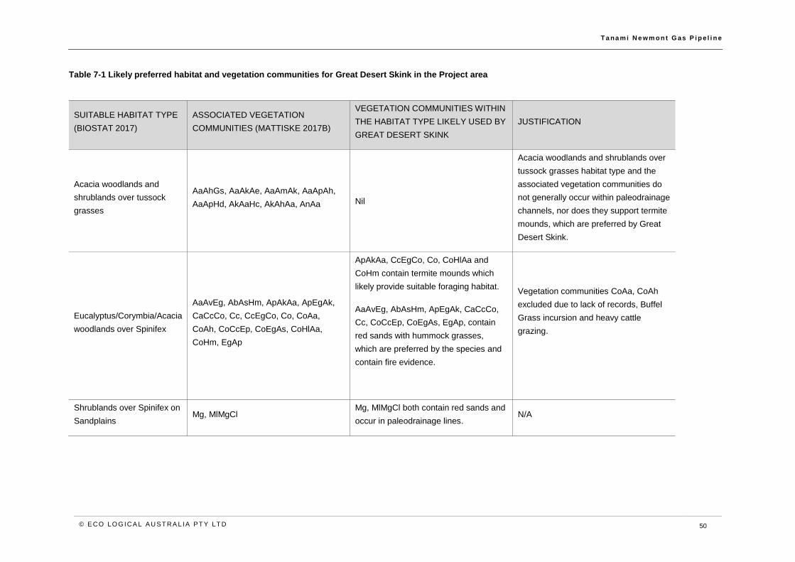
T a na m i N e wm o n t G as P i p e l i n e
© E CO LO G ICA L A U S T RA L IA P T Y LT D 50
Table 7-1 Likely preferred habitat and vegetation communities for Great Desert Skink in the Project area
SUITABLE HABITAT TYPE
(BIOSTAT 2017)
ASSOCIATED VEGETATION
COMMUNITIES (MATTISKE 2017B)
VEGETATION COMMUNITIES WITHIN
THE HABITAT TYPE LIKELY USED BY
GREAT DESERT SKINK
JUSTIFICATION
Acacia woodlands and
shrublands over tussock
grasses
AaAhGs, AaAkAe, AaAmAk, AaApAh,
AaApHd, AkAaHc, AkAhAa, AnAa Nil
Acacia woodlands and shrublands over
tussock grasses habitat type and the
associated vegetation communities do
not generally occur within paleodrainage
channels, nor does they support termite
mounds, which are preferred by Great
Desert Skink.
Eucalyptus/Corymbia/Acacia
woodlands over Spinifex
AaAvEg, AbAsHm, ApAkAa, ApEgAk,
CaCcCo, Cc, CcEgCo, Co, CoAa,
CoAh, CoCcEp, CoEgAs, CoHlAa,
CoHm, EgAp
ApAkAa, CcEgCo, Co, CoHlAa and
CoHm contain termite mounds which
likely provide suitable foraging habitat.
AaAvEg, AbAsHm, ApEgAk, CaCcCo,
Cc, CoCcEp, CoEgAs, EgAp, contain
red sands with hummock grasses,
which are preferred by the species and
contain fire evidence.
Vegetation communities CoAa, CoAh
excluded due to lack of records, Buffel
Grass incursion and heavy cattle
grazing.
Shrublands over Spinifex on
Sandplains Mg, MlMgCl
Mg, MlMgCl both contain red sands and
occur in paleodrainage lines. N/A
T a na m i N e wm o n t G as P i p e l i n e
© E CO LO G ICA L A U S T RA L IA P T Y LT D 51
7.3 Potent ial impacts to Great Desert Skink
As discussed in Section 2.2, a number of measures have been implemented over the design of the
Project to avoid and reduce impacts to the Great Desert Skink; however, the Project has the potential
to impact the species in a number of ways. The following potential impacts were identified through the
risk assessment process as presenting intermediate or higher inherent risks through either the
construction or operation phase:
• Mortality or injury of individuals through vehicle strike, trench fall or fire.
• Habitat loss or fragmentation through vegetation clearing and excavation.
• Habitat disturbance or degradation through altered fire regimes, increased weed incursion
and spills and leaks.
• Mortality of individuals through increase in feral predators.
A range of general environmental management measures, as well as species specific measures, will
be implemented to further avoid and reduce the likelihood and extent of impacts to the Great Desert
Skink and lower the risk ratings. A full discussion of both impacts and management measures is
provided below.
7.4 Assessment and mitigat ion of impacts
The following section provides a discussion of the potential impacts of the Project on the Great Desert
Skink. Measures to avoid or reduce these impacts are also presented. The assessment of the
significance of these impacts after all mitigation measures have been implemented takes account of
relevant policy guidance (Section 6) and considers both the likelihood of the impacts occurring and
their severity if or when they do.
Direct impacts
Mortality and injury
There are elements of the ecology of the Great Desert Skink that make it vulnerable to mortality and/or
injury from the Project and these are most acute during the construction phase of the project. The
species lives in underground burrows, is inactive inside the burrows during a large part of the day and
has a seasonal period of hibernation. Collectively, this means the species is at risk of being injured or
killed during daytime excavation of trenches. The species also lives in burrows as family groups,
suggesting that if a burrow is impacted during excavation, the risk of multiple animals being affected
is higher, than for a solitary species.
Further potential impacts during the construction period include the presence of open trenches during
pipe lay down, resulting in trench fall and fauna entrapment. This may cause injury or mortality of
individuals and is particularly relevant during nocturnal foraging by the species, when it ranges up to
100 m from burrows.
Additional risk of injury or mortality is associated with vehicle/machinery movements, which have the
potential to strike animals. Although this risk is lessened due to daytime hibernation, it will persist
beyond the construction period, as maintenance vehicles will traverse areas of suitable habitat for the
life of the pipelines.
Given the species’ relatively small home range, Project related fire ignition has the potential to cause
direct mortality of individuals present in the Project area. The species is known to move up to 10 km
or more to colonise new areas; however, the speed with which it can vacate an area impacted by fire
is likely to determine its survival in such an event.

T a na m i N e wm o n t G as P i p e l i n e
© E CO LO G ICA L A U S T RA L IA P T Y LT D 52
There are a range of mitigation measures that will be implemented to reduce the risk of mortality and
injury to the Great Desert Skink. Key measures to avoid injury and mortality of individuals include:
• Pre-clearance surveys to identify and clear burrows prior to construction, if they cannot
be avoided by micrositing, with a particular focus in areas of suitable habitat identified in
the Project area.
• Implementation of the Trench Fall Management Plan.
• Speed limits and driver / machinery operator environmental awareness program.
• Implementation of fire controls as identified in the Bushfire Management Plan.
The range of measures proposed in the EMP are commonly used to avoid and reduce impacts of
pipeline construction. The Great Desert Skink is a large reptile with a burrowing system that is readily
identified in the field. This provides for significantly more opportunity to avoid potential impacts to
individuals than for smaller, more cryptic species. Collectively, the measures outlined above are
expected to be highly effective in avoiding and reducing impacts to the Great Desert Skink. These
measures will be implemented within the entire Project area, but additional vigilance will be employed
in the north-western parts of the alignment, where the Project intersects paleodrainage channel
systems, where the species is known to be most prevalent.
Despite the implementation of the range of impact avoidance and reduction measures, it is possible
that isolated individuals may be injured or killed during construction of the Project; however, this is not
expected to result in a decrease of the population within the north-western Tanami Desert, which is
considered an important population, and estimated at less than 2,250 individuals (DotEE 2017a).
Mortality of a small number of animals is unlikely to affect the overall population stability. Furthermore,
the construction phase will last for less than 12 months, after which the risk of injury or mortality is
considered negligible.
Habitat loss and fragmentation
The Project area contains habitat critical to the survival of the Great Desert Skink, primarily in the form
of hummock grassland on sandplain and paleochannel environments. This habitat is located
throughout the Project area and within the 300 m survey corridor. In total, up to 7,526 ha of potential
Great Desert Skink habitat occurs in the 300 m survey corridor.
The Project will result in an initial temporary impact to habitat of 691.6 ha, associated with clearing the
25 m construction RoW required to construct the Project. Post-construction, the majority of the
alignment will be rehabilitated, with the exception of a 5 m permanent access track between KP0-3
and KP390-440 to enable ongoing access for maintenance of the pipeline and for the above ground
permanent facilities, leaving a residual impact to 26.8 ha of potential Great Desert Skink habitat.
The Project has the potential to fragment an existing burrow complex from foraging habitat which
includes predominantly termite mounds; however, given the species’ mobility, the temporary nature of
construction and the reduced permanent disturbance including restricted access tracks, it is unlikely
that the Project will permanently fragment habitat for the species.
Habitat clearing includes both the removal of areas that may be suitable for constructing burrows and
the destruction of existing burrows. Importantly, a range of measures will be implemented to ensure
that potential destruction of burrows will not result in injury or mortality to individuals (see above).
However, it is also important to understand that while burrows may be used for several years, overall
burrow use appears to be somewhat dynamic. Lizards are known to abandon burrows and excavate
new ones, with individuals moving up to 10 km to colonise new areas (DotEE 2017a). This is an
important consideration in that if burrows are destroyed, it is likely that animals will be able to construct
new ones outside of the impacted area.
T a na m i N e wm o n t G as P i p e l i n e
© E CO LO G ICA L A U S T RA L IA P T Y LT D 53
If ground disturbance impacts Great Desert Skink burrows during active breeding, this has the potential
to impact the breeding cycle of a family group. In addition to the reduced disturbance footprint to
minimise potential for impact, AGIT will undertake pre-clearance surveys to identify potential Great
Desert Skink burrows prior to construction. Where practicable, direct disturbance to burrows will be
avoided by micrositing. If impact to active burrows cannot be avoided, fauna will be allowed the
opportunity to move on and if individuals remain, AGIT will engage licensed wildlife handlers to
translocate individuals to pre-approved areas outside of the construction RoW, which contain suitable
habitat for the species.
The management and mitigation measures described above are expected to be effective in ensuring
only the minimum area of habitat and population disturbance will occur. Despite this, up to 26.8 ha of
habitat, based on the assessment of suitable habitats in Table 7-1, will be lost due to the Project;
however, this is considered small given the extent of suitable habitat mapped in the 300 m corridor
and known to occur elsewhere in the Tanami Desert (Section 7.1.1).
Indirect impacts
Habitat disturbance and degradation
In addition to the direct loss of habitat, as described above, the Project may also cause disturbance or
degradation of Great Desert Skink habitat. A key cause of disturbance includes weed incursion and
fire. Altered fire regimes have been shown to be a key threat to the Great Desert Skink, particularly
when fires are widespread, intense and lead to broad scale loss of vegetation. Weeds such as Buffel
Grass have the potential degrade habitat and increase fuel loads, contributing to more frequent and
more intense fire events, while pests such as rabbits and camels have been shown to destroy burrow
systems (predation by other pest species is addressed below).
Spills and leaks of hydrotest water or sewage also have the potential to impact the quality of Great
Desert Skink habitat particularly if a spill or leak occurs in proximity to active burrows and foraging
habitat, including termite mounds. AGIT will implement hazardous materials and spill response
management measures to avoid and minimise the potential impacts to habitat from unintended
releases to the environment.
The Project has the potential to increase fire frequency by introducing new ignition sources; however,
this is considered low risk after the implementation of mitigation measures such as:
• Bushfire Management Plan including, but not limited to:
o Restrictions on smoking and use of lighters and matches.
o Engagement of fire spotters during hot works.
o Provision of fire control equipment at active construction sites, accommodation
camps and hazardous materials storage and handling areas.
• Implementation of Spill Response Management Plan.
The movement of equipment, vehicles and personnel has the potential to introduce or spread weeds
in the Project area. Significant infestations of Buffel Grass are already present in the Project area
(BIOSTAT 2017), and these are not expected to be exacerbated by the Project. Strict weed
management measures will be implemented as outlined in the EMP and it is not anticipated that further
degradation of habitats will occur. Weed management of rehabilitated areas will be implemented to
ensure minimal weed incursion upon closure.
T a na m i N e wm o n t G as P i p e l i n e
© E CO LO G ICA L A U S T RA L IA P T Y LT D 54
Increased predation
Linear infrastructure is known to facilitate the dispersal of feral fauna. Foxes, cats, and rabbits are
known to occur in the Project area (BIOSTAT 2017). The Project is located adjacent to the Tanami
Highway and is not expected to further increase the dispersal of feral animals in the vicinity.
Furthermore, disturbed areas will be progressively rehabilitated, thereby reducing the opportunity for
pest populations to increase due to the Project.
Predation, particularly by cats and foxes (although dingoes may also be of concern) is a key threat to
the Great Desert Skink, particularly after fire disturbance. While the Project is not expected to increase
fire risk based on the application of management measures, vegetation clearance and disturbance of
burrows may increase exposure of Great Desert Skink to predators in a similar way.
Measures discussed above to reduce the impact of vegetation clearance, as well as burrow avoidance
and animal rescue from trench fall, are key measures for ensuring the exposure to predators is
minimised. Furthermore, progressive construction and rehabilitation will also minimise opportunities
for predation.
As discussed above, the Project is not expected to increase the potential dispersal pathways or
populations of feral animals such as cats and foxes.
7.5 Monitoring and cont ingencies
AGIT will implement monitoring as identified in the EMP, to ensure that construction and operation of
the Project are consistent with management measures. Monitoring will measure the success of these
actions against management objectives and targets. Monitoring during the construction phase will
verify compliance with trench inspection procedures, vehicle speed limits and fauna incident records.
Post-construction monitoring will focus on rehabilitation success of the pipeline corridor, in particular,
of keystone species cover, in comparison to the adjacent control areas.
For Greater Desert Skink, monitoring will focus on:
• Re-establishment of Triodia pungens and Melaleuca glomerata on sandplains and
paleochannels within Eucalyptus/Corymbia/Acacia woodlands over Spinifex habitat and
Shrublands over Spinifex on Sandplains habitat, in particular where they occur in
paleodrainage channels.
• Rehabilitation in proximity to recent records, which include TP001 survey site (BIOSTAT
2017) and areas of suitable fire age (three to 15 years), where practicable.
Triggers and contingencies will be implemented, in the event that monitoring demonstrates non-
compliance with management measure, failure to meet rehabilitation criteria or an increase in fauna
incidents.
7.6 Assessment of residual impacts
The Great Desert Skink population across the north-west Tanami Desert and Southern Tanami
Indigenous Protected Area (including parts of the Project area) is recognised as a key population for
the species, and important habitat exists in the Project area in the form of hummock grassland on
sandplains and palaeodrainage lines in association with termite mounds.
As discussed above, the Project will result in the loss of a small area of habitat for the species and
there is potential for other impacts to occur. In order to address this, a range of best practice impact
avoidance and reduction measures will be implemented. Following the implantation of such measures,
it is not expected the Project will result in significant impacts to the Great Desert Skink and will not be

T a na m i N e wm o n t G as P i p e l i n e
© E CO LO G ICA L A U S T RA L IA P T Y LT D 55
inconsistent with the approved conservation advice or recovery plan for the species. In addition, the
Project will not be inconsistent with the TAPs identified in Section 6.3. While the Project is within 2 km
of a likely population, the impact assessment has concluded no significant impacts to the species and
is not expected that it will impact the overall population viability or recovery. This is because:
• The Great Desert Skinks that occur within the Project area are a component of the broader
important population that extends across the north-west Tanami Desert. The total
population is estimated at less than 2,250 (DotEE 2017a) with a total population estimated
at 5,000 individuals, with the majority of known records outside the Project area.
• The Project is predominantly aligned with the existing Tanami Road which traverses the
Tanami Desert.
• Any identified burrows or populations will be avoided through micro-siting, where
practicable and/or individuals translocated.
• The majority of the Project area will be rehabilitated post-construction such that there will
be limited permanent impact and limited above ground infrastructure.
• The species is highly mobile and is expected to traverse the rehabilitated pipeline corridor,
such that any local population is not fragmented.
• The Project will result in clearing of a small area of important habitat, with residual clearing
impacts calculated at 26.8 ha. This is a small area in the regional context of the north-
west Tanami population and will not affect the overall area of occupancy for the species.
• There is the potential for mortality, injury or disruptions to breeding for isolated individuals,
however, active burrows will be avoided, where practicable. If individuals are affected, it
is unlikely that this will have population-wide effects.
• The population of Great Desert Skink extends across the Project area and the wider
region, and is most prevalent to the north-west of the Project area. The Project is not
expected to impact habitat to the extent that the species is likely to decline.
• The Project is not expected to increase abundance of introduced or invasive species,
already known to occur in the Project area, which may impact the species habitat.
• The Project is not expected to change or increase fire frequency.
• Given the relatively small permanent disturbance, in comparison to the regional
availability of habitat, and implementation of management measures, the project is
unlikely to substantially interfere with the recovery of the species.
Given that significant residual impacts are not likely to result from the Project, no offsets are required
or proposed for the Great Desert Skink, consistent with the EPBC Act Environmental Offsets Policy.
The overall outcomes for the Great Desert Skink include:
• Important habitat will remain in the vicinity of the Project area, including areas that are
rehabilitated post-construction.
• The north-west Tanami population of Great Desert Skink will remain in the vicinity of the
Project area.
• The conservation status of the Great Desert Skink will remain unchanged, as a result of
the Project.
T a na m i N e wm o n t G as P i p e l i n e
© E CO LO G ICA L A U S T RA L IA P T Y LT D 56
8 Greater Bilby (Macrotis lagotis)
The Greater Bilby is a solitary, medium-sized burrowing marsupial, which grows to 55 cm in length. It
is listed as Vulnerable under the EPBC Act.
8.1 Species prof ile
The following information is derived from AWC (2017), DotEE (2017b), EcOz Environmental (2013),
TSSC (2016b) and Pavey (2006).
Ecology and distribution
The Greater Bilby occurs in a number of disjunct locations in south-west Queensland, the Pilbara
region of Western Australia and the Tanami Desert in the Northern Territory, which are considered
separate management units. The current population across Australia is estimated at less than 10,000
individuals).
Across its range, Greater Bilby generally occupies three main habitat types including open tussock
grassland on uplands and hills, Acacia aneura (mulga) woodland/shrubland growing on ridges and
rises, and hummock grassland (Triodia spp.) in plains and alluvial areas.
The Greater Bilby occurs as a solitary individual; however, can aggregate in higher densities in areas
where food is abundant. It shelters in burrows during the day and intermittently at night. It can use up
to 18 burrows concurrently over several months. Burrows are up to 3 m deep and descend in a gentle
spiral and some have multiple entrances. Most burrows are isolated but can sometimes occur as
interconnecting burrows. An individual Greater Bilby may have over a dozen regularly used burrows
within its home range, and females demonstrate long-term site fidelity home range sizes in the
Northern Territory are estimated at 1.1 km to 3 km2.
The Greater Bilby is omnivorous and has an opportunistic feeding strategy which enables it to adapt
to conditions and availability. It feeds on invertebrates including lepidopteran larvae, termites, ants,
beetles, grasshoppers, seeds, and fungi. Important plant foods include seed from various grasses,
sedges and bulbs. The Greater Bilby generally excavates food from soil to expose shrub roots,
penetrate termite galleries or ant nest stores, expose bulbs and underground fungi. The Greater Bilby
is a nocturnal forager, emerging from its burrow after twilight.
Breeding of the Greater Bilby varies depending on seasonal conditions and food availability, producing
litters of one to three young, and in ideal conditions, can produce up to four litters per year. Young
remain in the pouch for approximately 75 days after which they remain in the maternal burrow for two
weeks prior to dispersing.
The National Recovery Plan for the species identifies potential critical habitat in the Northern Territory
as occurring in the Tanami bioregion, west of the Stuart Highway, characterised by sandy soils
dominated by hummock grasslands with an over-storey of low shrub cover dominated by Acacia and
Melaleuca species. The majority of previous records in the vicinity of the Project area occur in the
north, in association with paleodrainage channels.
Threats
Known threats to the Greater Bilby include predation by foxes and feral cats, particularly in the south
of its range. The presence of rabbits leads to an abundance of predators, and is therefore also
considered a threat to the Greater Bilby (TSSC 2016b).

T a na m i N e wm o n t G as P i p e l i n e
© E CO LO G ICA L A U S T RA L IA P T Y LT D 57
The fauna survey recorded scats and tracks of foxes and cats at most sites across the Project area
(BIOSTAT 2017). The existing presence of feral fauna in the Project area likely already impacts the
size and extent of the local population.
Habitat loss and fragmentation and too frequent fire events are also key threats to Greater Bilby across
its range and are potentially present in the Project area.
8.2 Greater Bi lby in the Project area
The Greater Bilby is known from recent and historical records (BIOSTAT 2017) to occur in the Project
area and the Project area intersects potential critical habitat for Greater Bilby, as defined in the National
Recovery Plan as including areas of the Tanami bioregion, west of the Stuart Highway, characterised
by sandy soils dominated by hummock grasslands with an over-storey of low shrub cover dominated
by Acacia and Melaleuca species (Pavey 2006).
The recent reconnaissance survey (BIOSTAT 2017) included both a desktop assessment which
yielded 109 records from north of Yuendumu (BIOSTAT 2017) and recorded evidence of Greater Bilby
activity, including burrows, in Eucalyptus/Corymbia/Acacia woodlands over Spinifex habitat, at both
the southern extent of the Project area (TP100) and in the north (TP024) (BIOSTAT 2017). This habitat
type was observed to support large Triodia hummocks of greater than 1 m in diameter, which are
preferred by Greater Bilby. A previous review of the biodiversity values of the Northern Territory
(Baker et al. 2005) identified 335 records of Greater Bilby from the Tanami bioregion.
Comprehensive survey effort from 2005 to 2012 conducted as part of the Regional Biodiversity
Monitoring program has consistently recorded Greater Bilby in the Tanami region, predominantly in
paleochannels and also in loamy and lateritic sand plains (Low Ecological 2009; 2010; 2012). The
results indicate that the Tanami region and in particular, the extensive paleochannels in the region, are
important refugia for vulnerable species, including Greater Bilby, due to the protection afforded from
exotic species and their ability to support greater plant production than the more elevated land systems.
A subsequent desktop assessment of fauna values for the Telstra Tanami Cable, extending from
Yuendumu to the Granites Gold Mine, yielded multiple records of Greater Bilby across the proposed
cable length, with a concentration of records across an approximately 10 km stretch where the cable
intersects the Western Tanami Paleodrainage System (Low Ecological 2016).
Greater Bilby has also been recorded in the vicinity, but outside of the Project area at the Twin Bonanza
mine, north-east of the Granites. Records include burrows, sightings fresh diggings and camera trap
recordings (EcOz Environmental 2013). These findings demonstrate the species distribution beyond
the Project area.
The field survey (BIOSTAT 2017) identified suitable habitat across most of the Project area; however,
on the basis of regional records (Low Ecological 2012, 2016), the preferred habitats are likely restricted
to areas of Eucalyptus/Corymbia/Acacia woodland over Spinifex which contain suitably large
hummocks, and which coincide with paleodrainage channels. Other habitats which may be suitable to
Greater Bilby include Riparian/Floodplain/Clay and Salt pans and Shrublands over Spinifex on
Sandplains habitat types.
As discussed in Section 6.2, in order to understand the potential impacts of the Project more fully, a
more detailed assessment of habitats was undertaken in order to define likely suitable habitat within
the Project area. Table 8-1 identifies suitable vegetation communities within each of the preferred
broad habitat types, likely to be suitable to Greater Bilby (mapped in Appendix A).

T a na m i N e wm o n t G as P i p e l i n e
© E CO LO G ICA L A U S T RA L IA P T Y LT D 58
Table 8-1 Likely preferred habitat and vegetation communities for Greater Bilby in the Project area
SUITABLE HABITAT TYPE
(BIOSTAT 2017)
ASSOCIATED VEGETATION
COMMUNITIES (MATTISKE 2017B)
VEGETATION COMMUNITIES WITHIN
SUITABLE HABITAT TYPES LIKELY USED
BY MNES (ELA ASSESSMENT)
JUSTIFICATION
Eucalyptus/Corymbia/Acacia
woodlands over Spinifex
AaAvEg, AbAsHm, ApAkAa, ApEgAk,
CaCcCo, Cc, CcEgCo, Co, CoAa, CoAh,
CoCcEp, CoEgAs, CoHlAa, CoHm, EgAp
AaAvEg, AbAsHm, ApAkAa, ApEgAk,
CaCcCo, Cc, CcEgCo, Co, CoCcEp,
CoEgAs, CoHm, EgAp, contain red sands
with hummock grasses, which are preferred
by the species.
Vegetation communities CoAa, CoAh,
excluded due to lack of records, Buffel
Grass incursion and heavy cattle grazing.
CoHlAa excluded as lacks Triodia
hummocks.
Eucalyptus/Corymbia/Acacia
woodlands over tussock
grasses
AaAhCo, AaCoGs, AaCoHc N/A
AaAhCo, AaCoGs, AaCoHc excluded due
to lack of Triodia in understorey and clayey
loam likely unsuitable for burrowing.
Riparian/Floodplain/Clay
and Salt pans Ec, EvAkAl, EvSl EvAkAl, EvSl
Ec excluded due lack of records and
degraded condition attributed to weed
infestation (Buffel Grass, Couch Grass and
Mimosa Bush).
Shrublands over Spinifex on
Sandplains Mg, MlMgCl
Mg, MlMgCl contain red sands on
paleodrainage channels. N/A
T a na m i N e wm o n t G as P i p e l i n e
© E CO LO G ICA L A U S T RA L IA P T Y LT D 59
8.3 Potent ial impacts to Greater Bi lby
As discussed in Section 2.2, a number of measures have been implemented over the design phase
of the Project to avoid and reduce the likelihood and extent of impacts; however, the Project has the
potential to impact the species in a number of ways. The following potential impacts were identified
through the risk assessment process as presenting intermediate or higher inherent risks during either
the construction or operation phase. They include:
The Project has the potential to result in the following impacts to the Greater Bilby:
• Mortality or injury through vehicle strike, trench fall or fire ignition.
• Habitat loss or disturbance through vegetation clearing and excavation.
• Habitat disturbance and degradation through altered fire regimes, introduction or spread of
weeds and spills and leaks.
• Mortality from increased feral predators.
A variety of general management measures, as well as species specific measures will be implemented
to further avoid and reduce the likelihood and extent of these impacts. A full discussion of both impacts
and management measures is provided below.
8.4 Assessment and mitigat ion of impacts
The following section provides an in-depth discussion of the potential impacts from the Project on the
Greater Bilby. Measures to avoid or reduce these impacts are also presented. The assessment of the
significant of these impacts after all mitigation measures have been implemented takes account of
relevant policy guidance (Section 6) and considers both the likelihood of the impacts occurring and
their severity if/when they do.
Direct impacts
Mortality or injury
The burrowing behaviour of the Greater Bilby makes it vulnerable to mortality or injury from daytime
ground disturbance activities for the Project. The species occupies burrows during daylight hours and
emerges after twilight to forage. Daytime ground disturbance has the potential to injure or kill
individuals hidden in underground burrows.
The species is solitary, so the direct impact of a burrow from ground disturbance, will likely only impact
one individual, unless it is a breeding female, in which case up to three young may be impacted.
Vehicle movements for construction activities and for inspection and maintenance throughout the
operational life of the pipeline, have the potential to result in fauna strike causing injury or mortality to
individuals. Given the species largely seeks shelter in burrows during the day and the majority of
vehicle movements will occur during daytime hours, it is unlikely that individuals will be above ground
during ground disturbance works and consequently, at risk of vehicle strike.
The presence of open trenches over night during pipe lay down may result in trench fall and fauna
entrapment of individuals during nocturnal foraging, causing injury or mortality of individuals.
Project related fire ignition has the potential to cause direct mortality of individuals present in the Project
area. Given the species’ mobility and home range, it is possible that during a fire event, individuals
may be able to readily flee a fire impacted area.

T a na m i N e wm o n t G as P i p e l i n e
© E CO LO G ICA L A U S T RA L IA P T Y LT D 60
AGIT will implement a range of management measures across the Project area to avoid and reduce
the mortality and injury of Greater Bilby. The Fauna Management Plan includes but is not limited to:
• Pre-clearance surveys to identify and clear burrows prior to construction, with a particular
focus on areas of suitable habitat identified in the Project area.
• Vehicle speed limits and limit night time driving.
• Minimise the length of open trench.
• Undertake trench and pipe inspections regularly throughout breaks in construction and
daily within five hours of sunrise and prior to backfilling, to identify any trapped fauna.
• Pipe lengths will be capped and inspected prior to welding to ensure no trapped fauna
within pipe lengths.
• Fauna ramps will be installed at regular intervals to enable fauna egress.
These measures are commonly used to avoid and reduce the impacts of pipeline construction and
vehicle strike. The Greater Bilby and its burrows are readily identified in the field which enables ease
of detecting and avoiding impacts to individuals.
Despite application of the above measures, it is possible that some individuals may be injured or killed
during construction of the Project; however, this is not expected to result in a decrease in the size or
security of the population in the Tanami region.
On the basis of the above management measures, it is considered likely that the Project will avoid
significant impacts to the Greater Bilby.
Habitat loss and fragmentation
The Project area contains habitat critical to the survival of the Greater Bilby, including sandy soils
dominated by hummock grasslands with an over-storey of low shrub cover dominated by Acacia and
Melaleuca species (Pavey 2006) in the Tanami bioregion, west of the Stuart Highway. Suitable habitat
in the Project area occurs in Eucalyptus/Corymbia/Acacia woodland over Spinifex habitat, where large
hummocks with diameter of 1 m or greater, occur. In total, up to 7,559.2 ha of potential Greater Bilby
habitat occurs within the 300 m survey corridor.
Based on the assessment of suitable habitats for Greater Bilby (Table 8-1), the Project will result in
temporary construction impact to up to 690.9 ha of suitable habitat associated with the clearing of the
25 m construction RoW. Post-construction, the majority of the Project area will be rehabilitated with
the exception of a 5 m permanent access track between KP0-3 and KP390-440 to enable ongoing
access for maintenance of the pipeline and for the above ground permanent facilities, leaving a residual
impact to approximately 27.1 ha of potential Greater Bilby habitat.
Vegetation clearing includes the loss of suitable habitat within the species’ range and loss of active
burrows. Given that individuals use multiple burrows concurrently over several months and over a
home range of 1.1 km to 3 km, it is likely that the loss of a single burrow will not significantly impact an
individual.
Given the home range of the Greater Bilby is estimated between 1.1 km2 and 3 km2, the species’
mobility and the restriction of the 5 m permanent access track to between KP0-3 and KP390-440, it is
unlikely that the temporary disturbance for construction of the Project will significantly fragment habitat
for the species.
As described above, a Fauna Management Plan will be implemented including pre-clearance surveys,
to identify Greater Bilby burrows, with a particular focus in the northern half of the Project area where
the construction RoW intersects paleodrainage channels. Where practicable, burrows will be avoided

T a na m i N e wm o n t G as P i p e l i n e
© E CO LO G ICA L A U S T RA L IA P T Y LT D 61
by micrositing. Progressive rehabilitation will reduce the residual impact to suitable habitat and enable
Greater Bilby to repopulate the majority of the disturbance area post-construction.
The management measures are considered likely to avoid and reduce potential impacts to Greater
Bilby habitat. Given the availability of habitat in the Tanami Desert, as demonstrated by findings of
reginal survey work, (Low Ecological 2009; 2010; 2012), the residual impact for the Project is
considered small, relative to the extent of available habitat.
Indirect impacts
Habitat disturbance and degradation
In addition to direct impacts, the Project has the potential to indirectly disturb or degrade Greater Bilby
habitat through soil compaction or land instability causing collapse of burrows, the introduction of fire
ignition sources increasing fire risk and the introduction or spread of weeds.
Weed invasion increases fuel loads and in turn can increase the frequency and intensity of fire events.
Given the extensive weed infestations currently present in the Project area, and AGIT’s commitment
to undertake weed control and implement hygiene measures, it is unlikely that the Project will
significantly impact potential habitat through the introduction or spread of weeds.
Given the Greater Bilby occupies underground burrows for shelter during daytime, it is vulnerable to
soil compaction and land instability associated with movement of vehicles and machinery. As
described above, pre-clearance surveys will be undertaken to identify Greater Bilby burrows. If burrows
are encountered, impacts will be avoided by micrositing where practicable. If burrows cannot be
avoided, individuals will be flushed from burrows and allowed the opportunity to move on. If individuals
do not move on, a licensed wildlife handler will be engaged to translocate individuals to pre-approved
areas of suitable habitat outside of the Project area.
Altered fire regimes can reduce food availability and make the Greater Bilby more prone to predation
by feral fauna. AGIT will implement a Bushfire Management Plan including the following measures:
• Restrictions on cigarettes, lighters and matches.
• Engagement of fire spotters during hot works.
• Provision of fire control equipment at active construction sites, accommodation camps
and hazardous materials storage and handling areas.
Vehicle and equipment movements for construction have the potential to introduce or spread weed
species. Significant infestations of Buffel Grass are already present in the Project area. Increased
weed presence can degrade the quality of Greater Bilby habitat and may reduce food availability. The
AGIT will implement a Weed Management Plan including weed control and strict hygiene measures
including wash down stations. Given the implementation of these measures, it is unlikely that the
Project will further degrade habitats due to weed incursion.
Spills and leaks of hydrotest water or sewage also have the potential to impact the quality of Greater
Bilby habitat, in the event that it occurs in proximity to active burrows and foraging habitat, including
termite mounds. AGIT will implement hazardous materials and spill response management measures
to avoid and minimise the potential impacts to habitat from unintended releases to the environment.
Increased predation
Linear infrastructure is known to facilitate the dispersal of feral fauna. A key threat to the Greater Bilby
is predation by foxes and cats. Foxes and cats are known to already occur across the Project area
(BIOSTAT 2017). The pipeline will be buried, and the AGIT will implement progressive rehabilitation

T a na m i N e wm o n t G as P i p e l i n e
© E CO LO G ICA L A U S T RA L IA P T Y LT D 62
of all but a 27.8 ha required for the 5 m permanent access track between KP0-3 and KP390-440. This
is expected to reduce the potential for feral fauna dispersal and potential impact of predation to the
Greater Bilby. On this basis, the presence of infrastructure is considered unlikely to significantly impact
a local population or the survival of the species.
8.5 Monitoring and cont ingencies
The AGIT will implement monitoring to ensure that construction and operation of the Project are
consistent with management measures. Monitoring will measure the success of these actions against
management objectives and targets. Monitoring during the construction phase will verify compliance
with general and species specific fauna management measures contained within the Fauna
Management Plan, including trench inspection procedures, vehicle speed limits and fauna incident
records. Post-construction monitoring will focus on rehabilitation success of the pipeline corridor, in
particular, the cover and health of keystone habitat species in comparison to adjacent control areas.
For Greater Bilby, monitoring will focus on:
• Triodia hummocks, Melaleuca and Acacia on predominantly loamy or lateritic sandy soils
in paleochannels and in proximity to recent records in the north and the south of the
Project area.
• Buffel Grass incursion in the rehabilitated construction RoW.
Triggers and contingencies will be implemented, in the event that monitoring demonstrates non-
compliance with management measures, failure to meet rehabilitation criteria or an increase in fauna
incidents.
8.6 Assessment of residual impacts
The Greater Bilby habitat available within the Tanami bioregion west of Stuart Highway, is potential
critical habitat for the species.
Suitable habitats occur in the Project area in the form of hummock and tussock grasslands on loamy
and sandy soils and evidence was recorded in association with spinifex in the north and south of the
Project area.
The Project will result in the loss of some habitat for the species, and this may include loss of burrows.
To avoid and reduce potential impacts, a range of measures will be implemented. Following the
implementation of these measures described above, it is not expected the Project will result in
significant impacts to the Greater Bilby and it will not be inconsistent with the approved conservation
advice or recovery plan for the species. In addition, the project will not be inconsistent with the TAPs
identified in Section 6.3. This is because:
• The Project will result in residual disturbance of up to 27.1 ha of potential Greater Bilby
habitat. Suitable habitat for Greater Bilby is not restricted to the Project area and occurs
elsewhere in the Tanami Desert and also extends into Western Australia and
Queensland. The Project is unlikely to impact the distribution of the species or lead to a
long-term decrease in the size of an important population.
• The extent of permanent disturbance for the 5 m permanent access track between KP0-
3 and KP390-440 is small in comparison to the extent of available habitat and is unlikely
to reduce the area of occupancy of an important population or fragment an important
population.

T a na m i N e wm o n t G as P i p e l i n e
© E CO LO G ICA L A U S T RA L IA P T Y LT D 63
• Active burrows will be avoided, where practicable through micrositing, and given the
species’ solitary behaviour, if a burrow cannot be avoided, it is likely that only an individual
may be impacted which will not impact the stability of a population, and is unlikely to
disrupt a breeding cycle of an important population.
• The Project is unlikely to impact habitat to the extent that the species will decline, due to
implementation of management measures, including fire and weed control.
• The Project is unlikely to result in an increase in feral fauna predators which threaten the
species.
• The Project is unlikely to increase the abundance of invasive or introduced weed species.
which may degrade habitat.
• The Project will not introduce disease that may cause the species to decline.
• Given the small permanent disturbance and implementation of management measures,
the Project is unlikely to substantially interfere with the recovery of the species.
Given that significant residual impacts are not likely to result from the Project, no offsets are required
or proposed for the Greater Bilby, consistent with the EPBC Act Environmental Offsets Policy.
The overall outcomes for the Greater Bilby include:
• Critical habitat will remain in the vicinity of the Project area.
• A population of the Greater Bilby is expected to be maintained in the vicinity of the Project
area.
• The conservation status of the Greater Bilby will remain unchanged, as a result of the
Project.

T a na m i N e wm o n t G as P i p e l i n e
© E CO LO G ICA L A U S T RA L IA P T Y LT D 64
9 Night Parrot (Pezoporus occidentalis)
The Night Parrot is a medium-sized nocturnal, ground feeding parrot which occurs in the arid and semi-
arid zones of Australia. It is listed as Endangered under the EPBC Act (DotEE 2017c).
9.1 Species prof ile
The following information is derived from BIOSTAT (2017), DotEE (2017c) and TSSC (2016c).
Ecology and distribution
The current distribution of the species is not known, with few historic records and observations. Historic
records exist from Western Australia, the Northern Territory, South Australia and Queensland;
however, reliable recent records only exist for two areas including the Pilbara region in Western
Australia and south-western Queensland where an unknown number of individuals were detected
every month during a survey extending from August 2013 to January 2016. This population is thought
to be part of a larger regional scale population.
Given the paucity of reliable survey data, there is no estimate for the population size or definition for
critical habitat for this species; however, most habitat records are from Triodia grasslands and or
chenopod shrublands in the arid and semi-arid zones and potentially also Astrebla sp, shrubby
samphire and chenopod associations, scattered trees and shrubs. Roosting and nesting sites are
reported as occurring in clumps of dense vegetation, predominantly old and large spinifex but
sometimes other vegetation types including chenopod shrublands. In south-western Queensland, the
Night Parrots regularly roosted in the same location despite dry condition when no Triodia seed was
available, suggesting that birds may remain sedentary under suitable conditions in some parts of their
range.
The Night Parrot feeds on seed and may move between samphire and spinifex, depending on the
presence or abundance of seed; however, given the lack of survey findings, this is inconclusive. There
is uncertainty over whether the Night Parrot requires water for drinking, with contradictory reports
indicated in the Conservation Advice for the species.
Tracking of a radio-tagged individual in southwest Queensland showed an individual flying 7.2 km from
its daytime roost. There were also long periods every night where this bird was unable to be located.
It is possible that birds fly significant distances at times (TSSC 2016c).
Threats
There are no known threats to the Night Parrot. Threats are likely to vary across its range, and in the
absence of direct evidence, assumed threats to the species include predation by feral cats and foxes,
soil disturbance in areas of suitable habitat, loss and degradation of habitat, competition for food by
livestock or feral herbivores, fire, Psittacine beak and feather disease and other avian diseases,
collection of birds or eggs, reduction in water availability, collision with fences and potential disturbance
from bird watching (TSSC 2016c).
Feral fauna including cats and foxes are known to occur in the Project area. In addition, pastoral
activities occur across the Project area and may pose a threat to suitable habitat. Altered hydrology
and habitat loss associated with mining activities may impact habitat availability and fencing around
mine infrastructure may result in collision causing injury or mortality. Avian disease has the potential
to occur across the species’ range including in the Project area. Given the lack of recent records from
the Tanami region or the Northern Territory, it is unlikely that bird watching or egg collection are threats
in the Project area.

T a na m i N e wm o n t G as P i p e l i n e
© E CO LO G ICA L A U S T RA L IA P T Y LT D 65
9.2 Night Parrot in the Project area
The Night Parrot has the potential to occur in the Project area based on the availability of some
potentially suitable habitat; however, the likelihood of occurrence is considered low, particularly given
the lack of species records and the extensive incursion of weed across the Project area which has
replaced much of the hummock grasslands.
The desktop assessment reported only one record of Night Parrot in the Project area, from the Mt
Doreen area in 1929 (Baker et al. 2005; BIOSTAT 2017) with no direct observations or secondary
evidence of Night Parrot occurrence in the Project area, or the vicinity since that finding.
The field survey (BIOSTAT 2017) recorded predominantly spinifex grassland plains of small clumping
Triodia species rather than clumps of large, dense hummocks preferred by the species, and extensive
Buffel Grass infestation throughout the Project area appears to have replaced what may have
previously been spinifex grassland (BIOSTAT 2017).
Large hummocks and some chenopod shrublands were recorded in the Project area, in association
with Eucalyptus/Corymbia/Acacia woodlands over Spinifex habitat.
The most suitable habitat areas for this species within the Project area are
Eucalyptus/Corymbia/Acacia woodlands over Spinifex and Riparian/Floodplains/clay and Salt pans
habitat types and Shrublands over Spinifex on Sandplains (BIOSTAT 2017).
As discussed in Section 5.1 in order to understand the potential impacts of the Project more fully, a
more detailed assessment of habitats was undertaken in order to better define potential habitat within
the Project area. Table 9-1Table 8-1 identifies suitable vegetation communities within each of the
preferred broad habitat types, which may offer suitable habitat to the Night Parrot (habitat mapped in
Appendix B).

T a na m i N e wm o n t G as P i p e l i n e
© E CO LO G ICA L A U S T RA L IA P T Y LT D 66
Table 9-1 Likely preferred habitat and vegetation communities for Night Parrot in the Project area
SUITABLE HABITAT TYPE
(BIOSTAT 2017)
ASSOCIATED VEGETATION
COMMUNITIES (MATTISKE 2017)
VEGETATION COMMUNITIES WITHIN
SUITABLE HABITAT TYPES LIKELY
USED BY MNES (ELA ASSESSMENT)
JUSTIFICATION
Eucalyptus/Corymbia/Acacia
woodlands over Spinifex
AaAvEg, AbAsHm, ApAkAa, ApEgAk,
CaCcCo, Cc, CcEgCo, Co, CoAa, CoAh,
CoCcEp, CoEgAs, CoHlAa, CoHm,
EgAp
AbAsHm, ApAkAa, ApEgAk, CaCcCo, Cc,
EcEgCo, Co, CoCcEp, CoEgAs, CoHlA,
CoHm, EgAp
AaAvEg, CoAa, CoAh excluded due to
Buffel grass incursion, scarcity of Triodia
hummocks, and evidence of heavy
cattle grazing.
Shrublands over Spinifex on
Sandplains Mg, MlMgCl Mg, MlMgCl N/A
Riparian/Floodplains/Clay
and Salt pans Ec, EvAkAl, EvSl EvSl
Ec and EvAkAl excluded due to weed
infestation.

T a na m i N e wm o n t G as P i p e l i n e
© E CO LO G ICA L A U S T RA L IA P T Y LT D 67
9.3 Potent ial impacts to Night Parrot
The Night Parrot has the potential to occur in the Project area based on the availability of some
potentially suitable habitat; however, the likelihood of occurrence is considered low. Nevertheless, a
precautionary approach has been adopted. A full impact assessment has been undertaken (below) to
understand impacts should it be found in the Project area and habitats that are considered suitable. A
variety of general management measures as well as species specific measures will be implemented
to further avoid and reduce the likelihood and extent of any impacts, and these are also presented
below.
As discussed in Section 2.2, a number of measures have been implemented over the design phase
of the project to avoid and reduce impacts to the Night Parrot; however, the Project has the potential
to impact the species in the following ways:
• Mortality or injury through fauna strike.
• Habitat loss through vegetation clearing.
• Habitat degradation and disturbance through altered fire regimes and introduction or
spread of weeds.
• Mortality of individuals through increased feral predators.
9.4 Assessment and mitigat ion of impacts
The following section provides a discussion of the potential impacts of the Project on the Night Parrot.
Measures to avoid or reduce these impacts are also presented.
In the unlikely event that Night Parrot is recorded in the Project area during construction of the Project,
the suite of general management measures implemented across the Project area, while not specific to
Night Parrot, will afford protection to this species. The assessment of the significance of potential
impacts after all mitigation measures have been implemented takes account of relevant policy
guidance (Section 6) and considers both the likelihood of the impacts occurring and their severity
if/when they do.
Direct impacts
Mortality and injury
If present, the Night Parrot may be vulnerable to injury or mortality from the movement of vehicles and
machinery for vegetation clearing due to the species’ ground dwelling nature. Ground disturbance will
occur predominantly during day time hours when the Night Parrot shelters in hummock grassland.
Noise and vibration of approaching vehicles and machinery are likely to flush any birds from
hummocks, allowing them to escape unharmed. Given construction will occur during day light hours,
Project related vehicle movements are not expected to impact nocturnal foraging of any individuals.
The Proponent will implement a range of management measures identified in the Fauna Management
Plan to reduce the risk of mortality and injury to the Night Parrot from vehicle and equipment
movements. Key measures include:
• Pre-clearance surveys of hummock grassland to identify potential Night Parrot nests or
roosts.
• Vehicle speed limits and restrictions on night-time driving across the Project area.
The range of measures proposed are commonly used to avoid and reduce impacts of pipeline
construction. Given the lack of records of Night Parrot in the Project area, short duration of construction

T a na m i N e wm o n t G as P i p e l i n e
© E CO LO G ICA L A U S T RA L IA P T Y LT D 68
and implementation of management measures, it is expected that potential impacts to Night Parrot will
be appropriate avoided.
Habitat loss
The Project area contains some habitat that may be suitable for the Night Parrot; however, given the
absence of records from the Northern Territory and the extent of weed incursion in the Project area,
the species is considered to have a low likelihood of occurrence.
Based on the assessment of habitats (Table 9-1), the Project will result in a temporary impact to up to
603.1 ha of suitable habitat for the Night Parrot, due to vegetation clearing and construction within the
25 m RoW, out of 6,589 ha of available suitable habitat within the mapped 300 m corridor. Post-
construction, all but a 5 m permanent access track between KP0 and KP03 and KP390 and KP440
will be rehabilitated, resulting in a permanent disturbance of 15.2 ha of suitable Night Parrot habitat.
Progressive rehabilitation of the Project area is expected to reinstate suitable habitat over time, that
can be used by Night Parrots, should they occur in the Project area.
Given the species’ mobility and recent evidence to suggest the species travels long distances, and the
limited clearing of potential habitat, it is unlikely that the Project will significantly fragment habitat for
the species.
Given there is no recorded population in the area, the limited availability of potential habitat in the
Project area and the prevalence of weed species replacing hummock grassland, vegetation clearing
for the Project is not expected to impact Night Parrot.
Indirect impacts
Invasive fauna
A likely threat to Night Parrot is predation by foxes and cats, and linear infrastructure such as pipelines
are known to facilitate the dispersal of feral fauna. Feral fauna including cats and foxes are known to
occur across the Project area.
The pipeline will be buried, and the Proponent will implement progressive rehabilitation of the
construction RoW to return the majority of the Project area to native vegetation, which is expected to
reduce the potential for the Project to increase the existing feral fauna presence. Given the majority of
the disturbance will be temporary, it is unlikely the Project will increase the presence of feral fauna in
the Project area, such that cats and foxes will present an increased threat to the Night Parrot, should
it be present in the Project area.
Disturbance and degradation of habitat
In addition to the direct loss of potential habitat as described above, the Project may degrade or
fragment habitats. Movements of vehicles, equipment and machinery for the Project may introduce or
spread weed species. Introduced weed species such as Buffel grass can replace or degrade native
species, reducing the extent and quality of vegetation and fauna habitat. Significant infestations of
Buffel grass already occur in the Project area, and appear to have replaced what is likely to have
previously been Triodia grasslands.
The Proponent will implement a Weed Management Plan including direct weed control in priority areas
and hygiene controls including washdown stations. On this basis, it is not anticipated that the Project
will further degrade suitable habitat through the introduction or spread of weeds.
Fire is a likely threat to the Night Parrot and the Project has the potential to increase the incidence of
fire and indirectly degrade or fragment suitable habitat through the introduction of fire ignition sources.

T a na m i N e wm o n t G as P i p e l i n e
© E CO LO G ICA L A U S T RA L IA P T Y LT D 69
The Proponent will implement a Bushfire Management Plan to reduce and avoid the potential impact
of fire, including the following key measures:
• Restrictions on smoking and use of lighters and matches.
• Engagement of fire spotters during hot works.
• Provision of fire control equipment at active construction sites, accommodation camps
and hazardous materials storage areas.
Given the application of fire controls, it is unlikely that the Project will result in increased fire frequency
resulting in degradation or fragmentation of suitable Night Parrot habitat in the Project area.
9.5 Monitoring and cont ingencies
The Proponent will implement monitoring to ensure that construction and operation of the Project are
consistent with management measures. Monitoring will measure the success of these actions against
management objectives and targets. Monitoring during the construction phase will verify compliance
with fauna management measures contained within the Fauna Management Plan, including vehicle
speed limits and fauna incident records. Post-construction monitoring will focus on rehabilitation
success of the pipeline corridor, in comparison to adjacent control areas.
Triggers and contingencies will be implemented, in the event that monitoring demonstrates non-
compliance with management measures, failure to meet rehabilitation criteria or an increase in fauna
incidents.
9.6 Assessment of residual impacts
The Night Parrot is not known to currently occur in the Northern Territory; and is considered to have a
low likelihood of occurrence in the Project area, given the lack of records and the significant infestation
of Buffel grass which has overtaken much of the hummock grassland which may have previously
provided suitable habitat. Some potential habitat does occur in the Project area in
Eucalyptus/Corymbia/Acacia over Spinifex habitat where large hummocks with diameter of 1 m or
greater occur. Some isolated and sparse chenopod also occurs in the Project area, which may provide
suitable habitat.
The Project is unlikely to result in significant impacts to the species and is not expected to be
inconsistent with the approved conservation advice or TAPs for the species. This is because:
• There is no recorded population of Night parrot in the Project area.
• The Project will result in permanent disturbance to a small area (15.2 ha) of suitable
habitat.
• Given there are no known records from the Project area, the Project is unlikely to disrupt
the breeding cycle of a population.
• The Project is unlikely to impact habitat to the extent that the species declines. The Project
area is already impacted by weed incursion, feral fauna activity and altered fire regimes.
• The Project is unlikely to result in an increase in invasive or feral predator species.
• The Project will not introduce disease that may cause the species to decline.
• Given the lack of records from the Project area and the implementation of management
measures to avoid and reduce potential impacts to previously unrecorded populations, it
is unlikely to interfere with the recovery of the species.
Given that significant residual impacts are not likely to result from the Project, no offsets are required
or proposed for the Night Parrot, consistent with the EPBC Act Environmental Offsets Policy.

T a na m i N e wm o n t G as P i p e l i n e
© E CO LO G ICA L A U S T RA L IA P T Y LT D 70
With consideration of the above information, the overall outcomes for Night Parrot include:
• No impact to known populations.
• Suitable habitat for the species will remain in the Project area and be available for use by
individuals.
• No exacerbation of potential threats to the species such as weed incursion, feral
predators, habitat loss or degradation.
• The conservation status of the Night Parrot will remain unchanged, as a result of the
Project.

T a na m i N e wm o n t G as P i p e l i n e
© E CO LO G ICA L A U S T RA L IA P T Y LT D 71
10 Princess Parrot (Polytelis alexandrae)
The Princess Parrot is a medium-sized parrot which is likely nomadic or eruptive. The Princess Parrot
is listed as Vulnerable under the EPBC Act.
10.1 Species prof ile
The following information is derived from BIOSTAT (2017), DotEE (2017d) and TSSC (2008).
Ecology and distribution
The Princess Parrot is confined to the arid regions of Western Australia, Northern Territory and South
Australia with populations believed to be concentrated in the Great Sandy, Gibson, Tanami and Great
Victoria Deserts and in the central ranges. It is likely an irregular visitor to most sites in its range and
its movements are largely unknown.
The population is estimated at approximately 5000 breeding birds and occur singly, in pairs or in small
flocks of up to 30 birds and breeds in small colonies of several pairs. Given its irregularity at most sites,
remoteness of preferred habitat and lack of information about its movements, it is difficult to accurately
estimate population size.
Within its range, the Princess Parrot inhabits sand dunes and sand flats, open savanna woodlands
and shrublands, consisting of scattered stands of Eucalyptus, Casuarina or Allocasuarina, with an
understorey of Acacia, Eremophila, Grevillea, Hakea, Senna and ground cover of Triodia. It also
utilises Eucalyptus or Allocasuarina in riverine or littoral areas. It nests in hollows or holes in Eucalyptus
trees or occasionally Allocasuarina decaisneana trees away from water and is thought to breed from
September to January; however, may breed at any time of year following rainfall.
The Princess Parrot feeds on seeds of some grasses including Triodia and other plants including
Acacia, Hakea and flowers, nectar and leaves.
There is currently no definition for critical habitat for the species or identified important populations.
Threats
The main identified threats to Princess Parrot are habitat degradation and reduction in food availability
due to altered fire regimes and grazing by introduced herbivores including sheep, rabbits and camels.
Potential threats include competition for resources, Psittacine beak and feather disease and collection
of eggs or young (TSSC 2008).
Pastoral activities and feral fauna are known to occur in the Project area and may already impact the
potential availability of habitat. Psittacine beak and feather disease has potential to occur across its
range. Given the lack of records from the Project area, it is unlikely that egg collection is a threat in the
Project area.
10.2 Princess Parrot in the Project area
The Princess Parrot is considered to have a low likelihood of occurrent in the Project area due to the
few records of the species in the vicinity and lack of evidence of suitable habitat. The desktop search
identified two records in the Tanami bioregion, reported by BIOSTAT (2017) as west of Tanami Road
in the Mt Doreen area (Baker et al. 2005; BIOSTAT 2017). These records are undated; however likely
predate 2005, given the publication date of these reports.
The field survey did not directly record the species or record secondary evidence of the species.
T a na m i N e wm o n t G as P i p e l i n e
© E CO LO G ICA L A U S T RA L IA P T Y LT D 72
The species displays eruptive behaviour and its occurrence across its likely range is sporadic and
fluctuating. Some habitat in the Project area, including Riparian/Floodplains/Clay and Salt pans habitat
and Eucalyptus/Corymbia/Acacia woodlands over Spinifex habitat, may satisfy habitat requirements
for the species; however, the scarcity of records to date in the vicinity indicate that the species’
utilisation of the Project area is likely rare.
As discussed in Section 5.1, in order to understand the potential impacts of the Project more fully, a
more detailed assessment of habitats was undertaken in order to better define likely suitable habitat
within the Project area. Table 10-1Table 8-1 identifies suitable vegetation communities within each of
the preferred broad habitat types, likely to be suitable to Princess Parrot (mapped in Appendix B).
There is currently no definition for critical habitat for Princess Parrot.
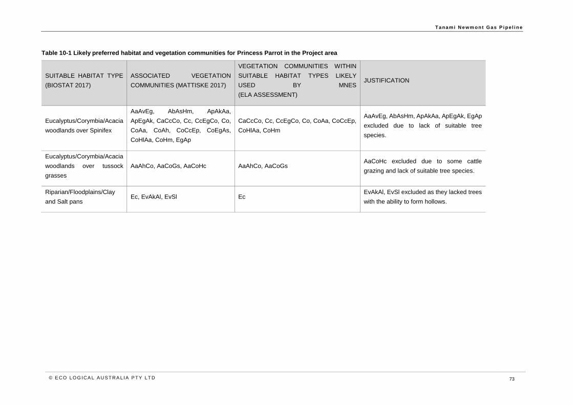
T a na m i N e wm o n t G as P i p e l i n e
© E CO LO G ICA L A U S T RA L IA P T Y LT D 73
Table 10-1 Likely preferred habitat and vegetation communities for Princess Parrot in the Project area
SUITABLE HABITAT TYPE
(BIOSTAT 2017)
ASSOCIATED VEGETATION
COMMUNITIES (MATTISKE 2017)
VEGETATION COMMUNITIES WITHIN
SUITABLE HABITAT TYPES LIKELY
USED BY MNES
(ELA ASSESSMENT)
JUSTIFICATION
Eucalyptus/Corymbia/Acacia
woodlands over Spinifex
AaAvEg, AbAsHm, ApAkAa,
ApEgAk, CaCcCo, Cc, CcEgCo, Co,
CoAa, CoAh, CoCcEp, CoEgAs,
CoHlAa, CoHm, EgAp
CaCcCo, Cc, CcEgCo, Co, CoAa, CoCcEp,
CoHlAa, CoHm
AaAvEg, AbAsHm, ApAkAa, ApEgAk, EgAp
excluded due to lack of suitable tree
species.
Eucalyptus/Corymbia/Acacia
woodlands over tussock
grasses
AaAhCo, AaCoGs, AaCoHc AaAhCo, AaCoGs AaCoHc excluded due to some cattle
grazing and lack of suitable tree species.
Riparian/Floodplains/Clay
and Salt pans Ec, EvAkAl, EvSl Ec
EvAkAl, EvSl excluded as they lacked trees
with the ability to form hollows.
T a na m i N e wm o n t G as P i p e l i n e
© E CO LO G ICA L A U S T RA L IA P T Y LT D 7 4
10.3 Potent ial impacts to Princess Parrot
The Princess Parrot has the potential to occur in the Project area based on the availability of some
potentially suitable habitat; however, the likelihood of occurrence is considered low. Nevertheless, a
precautionary approach has been adopted. A full impact assessment has been undertaken (below) to
understand impacts should it be found in the Project area and habitats that are considered suitable. A
variety of general management measures as well as species specific measures will be implemented
to further avoid and reduce the likelihood and extent of any impacts and these are presented below.
As discussed in Section 2.2, a number of measures have been implemented during the design phase
of the Project to avoid and reduce potential impacts to the Princess Parrot; however, the Project has
potential to impact the species through:
• Mortality or injury through vehicle and machinery movements for vegetation clearing and
excavation.
• Habitat loss through vegetation clearing and excavation.
• Habitat disturbance or degradation through the introduction or spread of weeds.
• Habitat degradation or fragmentation through altered fire regimes.
• Mortality through increased feral predators.
10.4 Assessment and mitigat ion of impacts
The following section provides an in-depth discussion of the potential impacts from the Project on the
Princess Parrot. Measures to avoid or reduce these impacts are also presented. The assessment of
the significant of these impacts after all mitigation measures have been implemented takes account of
relevant policy guidance (Section 3) and considers both the likelihood of the impacts occurring and
their severity if/when they do.
Direct impacts
Mortality and injury
The Princess Parrot is a highly mobile species and occurs in shrubland and bushland and nests in
trees. This means that in the unlikely event that individuals are present in the Project area, they will
likely move away from areas of habitat where ground disturbance occurs. If nests occur within tree
hollows or holes in the Project area, vegetation clearing has the potential to cause the direct loss of
young, if it coincides with active breeding.
Vehicle movements may also result in vehicle strike of individuals during flight, causing mortality or
injury.
The Proponent will implement a range of fauna management measures, contained within the Fauna
Management Plan, to avoid and reduce potential impacts to the Princess Parrot. Key measures
include:
• Pre-clearance surveys to identify and clear tree hollows in areas of potential habitat, prior
to construction, if they cannot be avoided by micro-siting.
• Implementation of vehicle speed limits.
These measures are commonly used to avoid and reduce impacts of pipeline construction. These
measures are considered to be highly effective and it is expected that they will be successful in
avoiding potential impacts to the Princess Parrot.

T a na m i N e wm o n t G as P i p e l i n e
© E CO LO G ICA L A U S T RA L IA P T Y LT D 7 5
Despite the implementation of the above measures, it is possible that previously unrecorded, isolated
individuals may be injured or killed during construction of the Project; however, this is not expected to
result in a decrease in the population.
Habitat loss and fragmentation
The Project area contains potential habitat for the Princess Parrot including Eucalyptus species with
potential to develop hollows, in proximity to water. This habitat occurs in Riparian/Floodplains/Clay and
Salt pans habitat, Eucalyptus/Corymbia/Acacia woodlands over tussock grasses habitat, and
Eucalyptus/Corymbia/Acacia woodlands over Spinifex habitat.
Based on the assessment of potential habitats (Table 10-1), the Project will result in loss of up to
431.5 ha of suitable habitat for the Princess Parrot associated with clearing of the 25 m construction
ROW required for construction, out of 4,808 ha mapped as available within the 300 m corridor. Post-
construction, all but 24.3 ha of suitable habitat will be rehabilitated. Progressive rehabilitation will be
undertaken across the majority of the Project area, to enable habitats to be reinstated in the temporary
disturbance area.
Habitat clearing includes direct loss of potential habitat and the loss of previously unrecorded nests in
tree hollows. A range of measures will be implemented to ensure that clearing will not result in injury
or mortality of individuals, as described above. It is not known if the species exhibits nest site fidelity,
or whether they utilise different hollows in subsequent breeding cycles; however, given the availability
of potential habitat outside of the Project area, it is likely that any Princess Parrot present in the area,
will retain access to suitable trees for nesting.
As described in Section 2.2, habitat clearance has been reduced to minimise the residual impact of
the Project and progressive rehabilitation will be undertaken to restore potential suitable habitat for
Princess Parrot. Given these measures, the absence of recent records from the Project area, and the
occurrence of the species outside of the Project area in the Great Sandy, Gibson, Tanami and Great
Victoria Deserts and in the central ranges, it is considered unlikely the Project will significantly impact
the species via habitat loss or fragmentation
Indirect impacts
Invasive fauna
Habitat degradation and competition for food due to introduced herbivores are likely threats to Princess
Parrot. While linear infrastructure is known to facilitate the dispersal of feral fauna, introduced
herbivores, including camels and rabbits are known to already occur in the Project area.
The pipeline will be buried, and the majority of the disturbance area will be progressively rehabilitated
post-construction, which is expected to reduce the potential for feral fauna dispersal. Given the majority
of the disturbance will be temporary, it is unlikely the Project will increase the presence of feral fauna
in the Project area, such that rabbits/camels will present an increased threat to Princess Parrot
habitats.
Disturbance or degradation of habitat
In addition to direct loss of habitat, vehicle and equipment movements for the Project have the potential
to indirectly impact the Princess Parrot through the introduction and spread of weed species,
increasing fire fuel loads and potentially increasing incidence and intensity of fire events.
Extensive infestations of Buffel Grass already occur in the Project area and the Project is considered
unlikely to exacerbate these. The Proponent will implement a Weed Management Plan including direct
weed control of priority areas and hygiene management including vehicle and equipment wash down

T a na m i N e wm o n t G as P i p e l i n e
© E CO LO G ICA L A U S T RA L IA P T Y LT D 7 6
and inspections, to prevent the introduction and spread of weeds. On this basis, it is considered unlikely
that the Project will further exacerbate habitat degradation through increase weed incursion and
subsequent fire risk.
The Project has the potential to indirectly impact Princess Parrot habitat through the introduction of fire
ignition sources. Fire has the potential to cause habitat degradation and fragmentation. The Proponent
will implement a Bushfire Management Plan to reduce and avoid the potential for Project related fire.
Key measures include:
• Restrictions on smoking and use of lighters and matches.
• Engagement of fire spotters during hot works.
• Provision of fire control equipment at active construction sites, accommodation camps
and hazardous materials storage areas.
These measures are expected reduce and avoid the potential for habitat disturbance or degradation
through fire events and on this basis, the Project is considered unlikely to significantly impact a local
population or the survival of the species.
10.5 Monitoring and cont ingencies
The Proponent will implement monitoring to ensure that construction and operation of the Project are
consistent with management measures. Monitoring will ensure the success of these actions against
management objectives and targets. Monitoring during the construction phase will verify compliance
with fauna management measures contained within the Fauna Management Plan. Post-construction
monitoring will focus on rehabilitation success of the pipeline corridor, in comparison to adjacent control
areas.
Triggers and contingencies will be implemented, in the event that monitoring demonstrates non-
compliance with management measures, failure to meet rehabilitation criteria or an increase in fauna
incidents.
10.6 Assessment of residual impacts
The Princess Parrot is thought to be confined to the Great Sandy, Gibson, Tanami and Great Victoria
Deserts, with potential habitat present in the Project area in Riparian/Floodplains/Clay and Salt pans
habitat and also Eucalyptus/Corymbia/Acacia woodlands over tussock grasses habitat, and
Eucalyptus/Corymbia/Acacia woodlands over Spinifex habitat.
As discussed above, the Project will result in the loss of some potential habitat. In order to address
this, a range of management measures will be implemented to avoid and reduce potential impacts to
Princess Parrot. Following the implementation of these measures, it is not expected that the Project
will result in significant impacts to the Princess Parrot and it will not be inconsistent with the approved
conservation advice for the species. In addition, the Project will not be inconsistent with the TAPs
identified in Section 6.3. This is because:
• There are no recent records of an important population of the species occurring in the
Project area.
• The Project will result in permanent disturbance of up to 24.3 ha of potential habitat.
• Given the lack of records and small disturbance footprint, the Project will not fragment an
existing important population, will not impact critical to the survival of the species and will
not disrupt the breeding cycle of an important population.

T a na m i N e wm o n t G as P i p e l i n e
© E CO LO G ICA L A U S T RA L IA P T Y LT D 7 7
• Given the lack of records, small disturbance footprint and implementation of management
measures to avoid and reduce potential impacts to, the Project is unlikely to cause the
species to decline.
• The Project is unlikely to increase the abundance of introduced or invasive species in the
Project area.
• The Project will not introduce disease that twill cause the species to decline.
• Given the small permanent disturbance and implementation of management measures,
the Project is unlikely to substantially interfere with the recovery of the species.
Given that significant residual impacts are not likely to result from the Project, no offsets are required
or proposed for the Princess Parrot, consistent with the EPBC Act Environmental Offsets Policy.
The overall outcomes for the Princess Parrot include:
• No impact to known populations of the species.
• Suitable habitat for the species will remain in the Project are and be available for use by
individuals.
• No exacerbation of known threats to the species.
• The conservation status of the Princess Parrot will remain unchanged as a result of the
Project.

T a na m i N e wm o n t G as P i p e l i n e
© E CO LO G ICA L A U S T RA L IA P T Y LT D 7 8
11 Dwarf Desert Spike-rush (Eleocharis papillosa)
The Dwarf Desert Spike-rush is a small perennial sedge, generally less than 10 cm in height. The
above ground parts grow in response to inundation or flooding and subsequently die back to tubers. It
is listed as Vulnerable under the EPBC Act (DotEE 2017f).
11.1 Species prof ile
The following information is derived from DotEE (2017f) and Mattiske (2017b).
Ecology and distribution
The Dwarf Desert Spike-rush is known from eight locations in the Northern Territory ranging from the
northern Tanami Desert to the southern parts of the Finke bioregion and the edge of the Simpson
Desert, including the Lander River, Rabbit Flat, Lake MacKay, three pastoral stations and Illparpa. The
populations are severely fragmented and distributed across six disjunct locations.
It is also known from South Australia and Western Australia. Given the species is cryptic and above
ground growth is highly ephemeral, detection can be difficult.
All records of the Dwarf Desert Spike-rush occur in ephemeral wetlands, predominantly freshwater or
semi-saline swamps, growing either in the open or under shrubs. In the Northern Territory, it has also
been recorded growing in vegetation communities dominated by Eucalyptus coolabah, Halosarcia
spp., Chenopodium auricomum and Eragrostis spp. During dry conditions, the species persists as
seed or root tubers in the soil.
There has been no estimate of the population of the species and it is likely to be difficult to quantify
due to its cryptic nature and ephemeral above ground growth.
Threats
Weed invasion, particularly by Couch Grass, is a recognised threat for Dwarf Desert Spike-rush and
has been documented at Illparpa Swamp and Stirling Swamp. Trampling by livestock is thought to be
a threat at some locations and has been observed to only grow under shrubs at Casuarina Swamp.
Changes to hydrological regime which may reduce the availability of surface water, is also a threat
(DotEE 2017f).
Given the existing extent of weed infestation in the Project area, it is possible that this has contributed
to the lack of suitable habitat and records.
11.2 Dwarf Desert Spike-rush in the Project area
There are five previous records of the Dwarf Desert Spike-rush within 30 km of the northern-most parts
of the Project area (
Figure 11-1). On the basis of these records, the desktop assessments for the Project reported the
species may occur within the Project area. It was therefore specifically targeted during the field
assessments in 2017 (Mattiske 2017b).
The field survey traversed the majority of the Project area, and did not record any individuals or
populations of Dwarf Desert Spike-rush. The specific landforms or species known to be associated
with the Dwarf Desert Spike-rush were also absent (Mattiske 2017b). The species predominantly
T a na m i N e wm o n t G as P i p e l i n e
© E CO LO G ICA L A U S T RA L IA P T Y LT D 7 9
occurs in ephemeral freshwater to semi-saline wetlands dominated by Eucalyptus coolabah,
Chenopodium auricomum, Halosarcia spp. and Eragrostis australasica (DENR 2006). These habitats
were not present within the Project area.
Some areas were not able to be surveyed due to access restrictions including creeklines; however,
the vegetation of exclusion areas was characterised via aerial photography interpretation, longer range
reconnaissance from areas able to be accessed and the use of other existing data. Consequently,
there is confidence that the field survey has adequately characterised potential for Dwarf Desert Spike-
rush habitat to occur in the Project area.
Overall, based on the location of previous records for the species and the outcomes of the field survey
in 2017, it is considered that the Dwarf Desert Spike-rush has a low likelihood of occurrence in the
Project area.

T a na m i N e wm o n t G as P i p e l i n e
© E CO LO G ICA L A U S T RA L IA P T Y LT D 8 0
Figure 11-1 Records of Dwarf Desert Spike-rush in the vicinity of the Project area

T a na m i N e wm o n t G as P i p e l i n e
© E CO LO G ICA L A U S T RA L IA P T Y LT D 8 1
11.3 Mitigation measures
In the unlikely event that unidentified individuals of Dwarf Desert Spike-rush occur in the Project area,
the range of management measures implemented across the Project area will ensure that potential
impacts to the species are avoided and minimised. These measures include:
• Pre-clearance surveys in advance of ground disturbance for watercourse crossings or
wetland areas, to identify potential previously unrecorded populations of Dwarf Desert
Spike-rush, where practicable.
• Use of direct weed control in priority areas including Napperby Creek and implementation
of hygiene controls including vehicle and equipment washdown to prevent weed
incursion.
• Restrictions on ignition sources.
In the event that individuals are recorded, disturbance of individuals will be avoided where practicable,
through micrositing. Where this is not possible, permission to disturb will be sought.
11.4 Predicted outcome
Given the Project area does not contain records of the Dwarf Desert Spike-rush or identified suitable
habitat and with the implementation of the range of general management measures contained within
the EMP, it is not expected that the Project will result in impacts to the Dwarf Desert Spike-rush and
the Project will not be inconsistent with the approved conservation advice for the species.

T a na m i N e wm o n t G as P i p e l i n e
© E CO LO G ICA L A U S T RA L IA P T Y LT D 8 2
12 Social, economic and cultural considerations
The following provides an overview of social, economic and cultural considerations associated with
the Project.
12.1 Social, economic and cultural profi le
The Project is located predominantly within the Central Desert Regional Council (CDRC) Local
Government Area (LGA) of the Northern Territory, with a lesser portion within the MacDonnell LGA
and it passes through the Southern Tanami Indigenous Protected Area in the Northern Territory,
Australia’s largest IPA at 10.16 million ha. This makes it the largest protected area within Australia.
The CDRC comprises the four wards; Northern Tanami Ward, Southern Tanami Ward, Anmatjere
Ward and Akityare Ward. The CDRC delivers services to these wards including aged care, children’s
services, community safety patrols, sport and recreation and local infrastructure.
Within these wards are a number of remote Indigenous communities including Atitjere, Engawala,
Lajamanu, Laramba, Nyirripi, Anmatjere, Willowra, Yuelamu and Yuendumu.
Yuendumu is the closest community to the Project area, located approximately 5 km north-west of the
pipeline. Yuendumu is approximately 3.5 hours’ drive from Alice Springs. The population of Yuendumu
is 759 and comprises predominantly Warlpiri and Anmatyeer Aboriginal people (Circle Advisory 2017).
The CLC is the principal Aboriginal representative organisation with the Project area. It is a statutory
authority under the Aboriginal Land Rights (Northern Territory) Act 1976 (Cth) and has functions under
the Native Title Act 1993 (Cth) and the Pastoral Land Act (NT).
The CLC delivers a range of services across the central desert area of the Northern Territory and acts
as an advocate and focal point for Aboriginal landowners with project developers and manages and
protects cultural and sacred sites.
12.2 Project employment
During the construction phase a workforce of 250-350 will be required. Operation and gas supply of
the pipeline and associated above ground facilities would be remotely controlled from a Control Centre
in Perth. All permanent above ground facilities will be unmanned. Field support and specialist services
based in Perth would support the Project on a fly in fly out basis, with local employment and service
providers used for routine tasks in the field.
12.3 Economic benef its of the proposed act ion
During the construction and commissioning phases, the Project will bring capital expenditure and
employment to the region.
When operational the Project will provide a reliable supply of natural gas to the Granites and Dead
Bullock Soak Mines (operated by Newmont) for power generation. At present the mines are powered
by two ageing diesel power stations.

T a na m i N e wm o n t G as P i p e l i n e
© E CO LO G ICA L A U S T RA L IA P T Y LT D 8 3
The Project will allow Newmont to:
• Replace the diesel power stations with modern, more efficient gas fired or dual fuelled
power stations
• Increase power capacity
• Significantly reduce the overall cost of power generation
• Expand the Tanami mine and it production facilities
• Increase the life of the mining operations.
12.4 Environmental and social co-benef its of the proposed action
Regional environmental and social benefits of reducing the reliance of the Granites and Dead Bullock
Soak Mines on diesel power generation include:
• Reduce carbon emissions intensity from the mining operations
• Reduced truck haulage on the Tanami Road resulting from less reliance on diesel at the
mines
• Improved safety on the Tanami Road from fewer vehicle movements
• Reduced fauna mortality on the Tanami Road from fewer vehicle movements
• Lower maintenance requirements on the Tanami Road from fewer vehicle movements.
12.5 Social considerations
Social impacts and opportunities
AGIT has prepared an Economic and Social Impact Assessment, Management Plan and Stakeholder
Engagement Plan for the Project to ensure to ensure that the broader economic and social
consequences of the Project are appropriately managed and that the positive opportunities for
stakeholders and local businesses to engage in the Project are identified and acted upon.
Cultural heritage management
Aboriginal sacred sites and archaeological sites are located in proximity to the proposed Project
alignment. Consistent with the requirements of the Northern Territory Aboriginal Sacred Sites Act and
the Heritage Act, AGIT has engaged with Aboriginal traditional owners and commissioned survey of
the pipeline alignment. AGIT has initiated the processes under the NTASS Act to identify Aboriginal
sacred sites within and near the project area and will comply with the Authority Certificate and
Restricted Work Areas established by the Aboriginal Areas Protection Authority. Avoidance and
management measures have been incorporated into a Cultural Heritage Management Plan for the
Project.
Through the CLC, areas of cultural sensitivity were identified early in the planning phase of the Project
and restrictions on land access for the purposes of flora and fauna surveys were imposed. AGIT has
at all times sought to undertake investigatory works in a manner consistent with Aboriginal traditional
owner requirements and the restrictions on access resulted in limitations to the survey work
undertaken, as noted in Section 5 above.
Stakeholder consultation
AGIT is implementing a Stakeholder Engagement Strategy to inform local stakeholders on the overall
scope, timing and nature of the Project.
To date stakeholders engaged with have included:
• Central Land Council

T a na m i N e wm o n t G as P i p e l i n e
© E CO LO G ICA L A U S T RA L IA P T Y LT D 8 4
• Pastoral landowners along the pipeline route
• Northern Territory Government agencies
• Chamber of Commerce NT – Alice Springs regional office
• Members of Yuendumu, Laramba, and Lajamanu Traditional Owner Groups
• The public, through information sessions in Alice Springs
All pastoralists, landholders and relevant government agencies and local government have been
consulted and required consents, agreements or approvals have been obtained or are in the process
of being obtained in advance of construction.
Ongoing engagement will occur with Aboriginal land holders and Native Title Claimant Groups through
the CLC, pastoral land holders, and parties with mining and petroleum interests in the region,
consistent with the Land Users sub-plan of the EMP.
AGIT recognises that the Project passes through the South Tanami Indigenous Protected Area and
more generally though Aboriginal land in which traditional cultural land management practices are
maintained. The Warlpiri rangers manage Southern Tanami Indigenous Protected Area in accordance
with the Southern Tanami Indigenous Protected Area Plan of Management (CLC 2012). A portion of
the Project is located within the Yuendumu management region of the IPA.
The Plan of Management for the IPA establishes four management themes and associated
management objectives, summarised below. The Project design and controls included in the EMP are
consistent with the objectives of the IPA, where relevant:
• Keeping culture strong:
o Support traditional owners to fulfil cultural obligations to care for country.
o Assist traditional owners to manage indigenous ecological knowledge and
associated cultural information.
o Develop maintain and protect infrastructure that supports traditional owners in
visiting their country.
• Keeping country strong:
o Manage fire.
o Reduce introduction, spread and proliferation of weed species.
o Protect customary, ecological and infrastructure assets from impacts of feral
animals and livestock.
o Maintain or restore integrity of significant habitats through prevention of soil
disturbance and mitigation of existing problems.
o Address data deficiencies and undertake monitoring related to customary and
ecological values.
• Two-way environmental law and education:
o Develop Warlpiri Ranger skills.
o Develop education pathways to employment outcomes in conservation and land
management.
• Jobs and economic development:
o Provide employment opportunities for rangers and cultural advisors.
o Broaden the funding base of the IPA and Warlpiri Ranger programs.

T a na m i N e wm o n t G as P i p e l i n e
© E CO LO G ICA L A U S T RA L IA P T Y LT D 8 5
13 Conclusion
The Project has been deemed a Controlled Action requiring assessment and approval under the EPBC
Act before it can proceed. The relevant controlling provision was listed threatened species.
The assessment of MNES recorded or likely to occur in the Project area identified two threatened
species, including the Great Desert Skink recorded from one location in the Project area and known
from the north-west Tanami Desert and the Southern Tanami Indigenous Protected Area, and the
Greater Bilby, which was recorded from two locations in the north and south of the Project area and is
known to occur more broadly in the Tanami Desert.
Two further species, the Night Parrot and Princess Parrot have potential to occur, based on the
availability of some suitable habitat.
The impact assessment concluded that there would be no significant impact to these species following
the application of the mitigation hierarchy including design optimisation and the implementation of
comprehensive management measures identified in the EMP. On this basis, the Project is consistent
with the principles of Ecologically Sustainable Development, the Precautionary Principle and approved
guidance and conservation advice for the identified species.
Management measures proposed are commonly applied to linear infrastructure projects of this type
and are expected to be effective and all management measures are agreed to by the Construction
Contractor. No residual significant impacts are expected for any MNES from the Project and on this
basis, no offsets are required or proposed.
T a na m i N e wm o n t G as P i p e l i n e
© E CO LO G ICA L A U S T RA L IA P T Y LT D 8 6
14 References
Australian Wildlife Conservancy (AWC) 2017. Species Profile – Greater Bilby [Online], Available at:
http://www.australianwildlife.org/wildlife/greater-bilby.aspx Accessed 20 November 2017.
Baker B, Price O, Woinarski J, Gold S, Connors G, Fisher A and Hempel C, 2005. Northern Territory
Bioregions – Assessment of key biodiversity values and threats. Department of Natural Resources,
Environment and the Arts, Northern Territory.
BIOSTAT Pty Ltd (BIOSTAT) 2017. Preliminary Fauna Survey of the proposed Tanami Gas Pipeline,
Northern Territory. Unpublished report prepared for Australian Gas Industry Group.
Brocklehurst P, Lewis D, Napier D, Lynch D 2007. Northern Territory Guidelines and Field
Methodology for Vegetation Survey and Mapping. Technical Report No. 02/2007D. Department of
Natural Resources, Environment and the Arts, Palmerston, Northern Territory.
Circle Advisory Pty Ltd (Circle Advisory) 2017. Social and Economic Settings for the Tanami Gas
Pipeline. Prepared for AGIT.
Central Land Council (CLC) 2012. Looking after our country: Southern Tanami Indigenous Protected
Area Plan of Management.
Department of the Environment (DoE) 2013a. Matters of National Environmental Significance
Significant Impact Guidelines 1.1 Environment Protection and Biodiversity Conservation Act 1999.
Commonwealth of Australia, Canberra.
Department of the Environment (DoE) 2013b. Threat abatement plan for predation by the European
red fox (2008) – Five Yearly Review 2013. Commonwealth of Australia, Canberra.
Department of the Environment (DoE) 2015. Threat abatement plan for predation by feral cats.
Commonwealth of Australia, Canberra.
Department of the Environment and Energy (DotEE) 2016. Threat abatement plan for competition and
land degradation by rabbits. Commonwealth of Australia, Canberra.
Department of the Environment and Energy (DotEE) 2017a. Species Profile and Threats Database
Liopholis kintorei - Great Desert Skink, Tjakura, Warrarna, Mulyamiji [Online], Available at:
http://www.environment.gov.au/cgi-bin/sprat/public/publicspecies.pl?taxon_id=83160 Accessed 7
November 2017.
Department of the Environment and Energy (DotEE) 2017b. Species Profile and Threats Database
Macrotis lagotis – Greater Bilby [Online], Available at: http://www.environment.gov.au/cgi-
bin/sprat/public/publicspecies.pl?taxon_id=282 Accessed 9 November 2017.
Department of the Environment and Energy (DotEE) 2017c. Species Profile and Threats Database
Pezoporus occidentalis – Night Parrot [Online], Available at: http://www.environment.gov.au/cgi-
bin/sprat/public/publicspecies.pl?taxon_id=59350 Accessed 9 November 2017.
Department of the Environment and Energy (DotEE) 2017d. Species Profile and Threats Database
Polytelis alexandrae – Princess Parrot [Online], Available at: http://www.environment.gov.au/cgi-
bin/sprat/public/publicspecies.pl?taxon_id=758 Accessed 10 November 2017.

T a na m i N e wm o n t G as P i p e l i n e
© E CO LO G ICA L A U S T RA L IA P T Y LT D 8 7
Department of the Environment and Energy (DotEE) 2017e. Species Profile and Threats Database –
Dasycercus cristicauda – Crest-tailed Mulgara [Online], Available at:
http://www.environment.gov.au/cgi-bin/sprat/public/publicspecies.pl?taxon_id=328 Accessed 20
November 2017.
Department of the Environment and Energy (DotEE) 2017f. Species Profile and Threats Database
Eleocharis papillosa – Dwarf Desert Spike-rush [Online]. Available at:
http://www.environment.gov.au/cgi-bin/sprat/public/publicspecies.pl?taxon_id=2519 Accessed 13
November 2017.
Department of Health (DoH) 2014. Code of Practice for On-site Wastewater Management. Northern
Territory Government, Casuarina.
Department of Land and Resources Management (DLRM) 2013. Alice Springs Regional Weed
Management Plan 2013-2018. Northern Territory Government, Palmerston.
Department of Natural Resources (DENR) 2006. Threatened Species of the Northern Territory Dwarf
Desert Spike-rush. Northern Territory Government.
Department of Sustainability, Environment, Water, Population and Communities (DSEWPaC) 2012.
Environment Protection and Biodiversity Conservation Act 1999 Environmental Offsets Policy October
2012. Commonwealth of Australia, Canberra.
EcOz Environmental Services (EcOz Environmental) 2013. Flora and Fauna Report Dry Season, May
2013 Twin Bonanza Gold Project. Unpublished report prepared for ABM Resources NL.
Low Ecological Services (Low Ecological) 2009. Regional Biodiversity Monitoring in the Tanami
Desert: Summary of 6th Survey, Late Dry Season, October-November 2008. Unpublished report for
Newmont Tanami Pty Lt and Tanami Gold N/L.
Low Ecological Services (Low Ecological) 2010. Regional Biodiversity Monitoring in the Tanami
Desert: Summary of 7th Survey, Late Dry Season, October-November 2009. Unpublished report for
Newmont Tanami Pty Lt and Tanami Gold N/L.
Low Ecological Services (Low Ecological) 2012. Regional Biodiversity Monitoring in the Tanami
Desert. Summary of 8th Survey, Late Dry Season, October – November – December, 2012.
Unpublished report for Newmont Tanami Pty Lt and Tanami Gold N/L.
Low Ecological Services (Low Ecological) 2016. Telstra Tanami Cable Fauna Desktop Assessment.
Unpublished report.
Mattiske Consulting Pty Ltd (Mattiske) 2017a. Tanami Gas Pipeline Terrestrial Ecology Desktop
Assessment: Tanami Desert, Northern Territory – Flora, Vegetation and Fauna Values. Unpublished
report prepared for DBP.
Mattiske Consulting Pty Ltd (Mattiske) 2017b. Flora and Vegetation Assessment of the Tanami Gas
Pipeline Project Area, Northern Territory. Unpublished report prepared for AGI Tanami Pty Ltd.
McAlpin S. 2001. A Recovery Plan for the Great Desert Skink (Egernia kintorei) 2001-2011. Arid Lands
Environment Centre, Alice Springs.
Moore D, Kearney M. R, Paltridge R, McAlpin S, Stow A. 2015 Is fire a threatening process for Liopholis
kintorei, a nationally listed threatened skink? Wildlife Research 42, 207-216.

T a na m i N e wm o n t G as P i p e l i n e
© E CO LO G ICA L A U S T RA L IA P T Y LT D 8 8
Northern Territory Environmental Protection Authority (NT EPA) 2013. Guidelines for Assessment of
Impacts on Terrestrial Biodiversity. Northern Territory Government.
Pavey C. 2006. National Recovery Plan for the Greater Bilby Macrotis lagotis. Department of Natural
Resources, Environment and the Arts, Northern Territory.
Pavey C, Cole J, Woinarski J. 2006. Threatened Species of the Northern Territory – Crest-tailed
Mulgara. Northern Territory Government.
Strategen Environmental Consultants Pty Ltd (Strategen). 2012. Dampier to Bunbury Natural Gas
Pipeline Stage 5 Looping Expansion Project Five-year Performance Review (2007-2012). Prepared
for DBNGP (WA) Nominees Pty Ltd
Threatened Species Scientific Committee (TSSC) 2008. Commonwealth Conservation Advice on
Polytelis alexandrae Princess Parrot. Department of the Environment, Water, Heritage and the Arts,
Canberra.
Threatened Species Scientific Committee (TSSC) 2010. Commonwealth Listing advice on Eleocharis
papillosa (Dwarf Desert Spike-rush). Department of Sustainability, Environment, Water, Population
and Communities, Canberra.
Threatened Species Scientific Committee (TSSC) 2016a. Conservation Advice for Liopholis kintorei
Great Desert Skink. Department of the Environment and Energy, Canberra.
Threatened Species Scientific Committee (TSSC) 2016b. Conservation Advice Macrotis lagotis
Greater Bilby. Department of the Environment, Canberra.
Threatened Species Scientific Committee (TSSC) 2016c. Conservation Advice Pezoporus occidentalis
Night Parrot. Department of the Environment, Canberra.
WorleyParsons Services Pty Ltd (WorleyParsons) 2016. Tanami Gas Pipeline FEED Project Definition
Report. Unpublished report for Power and Water Corporation.

T a na m i N e wm o n t G as P i p e l i n e
© E CO LO G ICA L A U S T RA L IA P T Y LT D
Appendix A Records and potential habitat for Great Desert Skink and Greater Bilby in the Project area

T a na m i N e wm o n t G as P i p e l i n e
© E CO LO G ICA L A U S T RA L IA P T Y LT D
Appendix B Potential habitat for Night Parrot and Princess Parrot in the Project area

T a na m i N e wm o n t G as P i p e l i n e
© E CO LO G ICA L A U S T RA L IA P T Y LT D
Appendix C EPBC Referral and Decision

T a na m i N e wm o n t G as P i p e l i n e
© E CO LO G ICA L A U S T RA L IA P T Y LT D
Appendix D Notice of Intent and Statement of Reasons

T a na m i N e wm o n t G as P i p e l i n e
© E CO LO G ICA L A U S T RA L IA P T Y LT D
Appendix E DBP HSE Policy and Statement of Commitment

T a na m i N e wm o n t G as P i p e l i n e
© E CO LO G ICA L A U S T RA L IA P T Y LT D
Appendix F Reconnaissance Fauna Report

T a na m i N e wm o n t G as P i p e l i n e
© E CO LO G ICA L A U S T RA L IA P T Y LT D
Appendix G Flora and Vegetation Assessment

T a na m i N e wm o n t G as P i p e l i n e
© E CO LO G ICA L A U S T RA L IA P T Y LT D
Appendix H Environmental Management Plan

T a na m i N e wm o n t G as P i p e l i n e
© E CO LO G ICA L A U S T RA L IA P T Y LT D
Appendix I Trench Clearing Procedure

T a na m i N e wm o n t G as P i p e l i n e
© E CO LO G ICA L A U S T RA L IA P T Y LT D
Appendix J Rehabilitation Plan
T a na m i N e wm o n t G as P i p e l i n e
© E CO LO G ICA L A U S T RA L IA P T Y LT D
HEAD OFFICE
Suite 2, Level 3
668-672 Old Princes Highway
Sutherland NSW 2232
T 02 8536 8600
F 02 9542 5622
SYDNEY
Suite 1, Level 1
101 Sussex Street
Sydney NSW 2000
T 02 8536 8650
F 02 9542 5622
HUSKISSON
Unit 1, 51 Owen Street
Huskisson NSW 2540
T 02 4201 2264
F 02 9542 5622
CANBERRA
Level 2
11 London Circuit
Canberra ACT 2601
T 02 6103 0145
F 02 9542 5622
NEWCASTLE
Suites 28 & 29, Level 7
19 Bolton Street
Newcastle NSW 2300
T 02 4910 0125
F 02 9542 5622
NAROOMA
5/20 Canty Street
Narooma NSW 2546
T 02 4302 1266
F 02 9542 5622
COFFS HARBOUR
35 Orlando Street
Coffs Harbour Jetty NSW 2450
T 02 6651 5484
F 02 6651 6890
ARMIDALE
92 Taylor Street
Armidale NSW 2350
T 02 8081 2685
F 02 9542 5622
MUDGEE
Unit 1, Level 1
79 Market Street
Mudgee NSW 2850
T 02 4302 1234
F 02 6372 9230
PERTH
Level 1 Bishops See
235 St Georges Tce
Perth WA 6000
T 08 6218 20
F 02 9542 5622
WOLLONGONG
Suite 204, Level 2
62 Moore Street
Austinmer NSW 2515
T 02 4201 2200
F 02 9542 5622
GOSFORD
Suite 5, Baker One
1-5 Baker Street
Gosford NSW 2250
T 02 4302 1221
F 02 9542 5622
MELBOURNE
Level 1, 436 Johnston St
Abbotsford, VIC 3076
T 1300 646 131
BRISBANE
Suite 1, Level 3
471 Adelaide Street
Brisbane QLD 4000 T 07 3503 7192
ADELAIDE
2, 70 Pirie Street
Adelaide SA 5000
T 08 8470 6650
F 02 9542 5622
1300 646 131
www.ecoaus.com.au


