53
TAREBREECHES CREEK-TUSCUMBIA RIVER CANAL WATERSHED IMPLEMENTATION PLAN

TAREBREECHES CREEK-TUSCUMBIA
RIVER CANAL WATERSHED
IMPLEMENTATION PLAN

2
Tarebreeches Creek-Tuscumbia
River Canal Watershed
Implementation Plan
Prepared for:
Tennessee-Tombigbee River/North Independent Streams Basin Team
Mississippi Department of Environmental Quality
Developed by:
Tarebreeches Creek-Tuscumbia River Canal Watershed Implementation Team
Prepared by:
Mississippi Soil and Water Conservation Commission
P.O. Box 23005
Jackson, MS 39225

3
Table of Contents
I. Executive Summary 6
II. Vision Statement 8
III. Mission Statement 8
IV. Watershed Implementation Team 9
V. Watershed Description 10
VI. Stakeholder Interests 14
VII. Water Resources 15
A. History of Activity in the Watershed 15
B. Wildlife and Fisheries 16
C. Designated Use Classifications and Water Quality Standards 16
D. Current Status of Waterbodies in the Watershed 18
E. TMDLs 18
VIII. Watershed Management Actions 19
Agricultural Best Management Practices
A. Sediment and Nutrient BMPs 19
1. Stakeholders Interests 19
2. Goals/Objectives 19
3. Management Actions 19
4. Project Tracking/Assessment of Progress 20
5. Desired Results/Benefits 21
6. Roles/Responsibilities 22
7. Budget 22
IX. Education/Outreach Activities 23
A. Educational Activities to be implemented 23
1. Signage 23
a. Indicators 24
b. Schedule 24
c. Budget 24
2. Landowner Meeting and Field Days 24
a. Indicators 24
b. Schedule 25
c. Budget 25
3. Fact Sheets 25
a. Indicators 25
b. Schedule 25
c. Budget 26
4
4. Watershed Harmony Puppet Show 26
a. Indicators 26
b. Schedule 26
c. Budget 26
5. Alcorn County Fair 27
a. Indicators 27
b. Schedule 27
c. Budget 27
6. Water Bill Mailers 28
a. Indicators 28
b. Schedule 28
c. Budget 28
7. Presentations 29
a. Indicators 29
b. Schedule 29
c. Budget 29
8. Radio Advertisements 29
a. Indicators 29
b. Schedule 29
c. Budget 30
9. Adopt-A-Stream 30
a. Indicators 30
b. Schedule 30
c. Budget 30
10. Total Projected Cost of Education/Outreach Activities 31
11. Total Budget for Tarebreeches Creek-Tuscumbia River Canal
Watershed Implementation Plan 31
X. Evaluation 32
A. Plan Evaluation Procedure 32
B. Implementation Evaluation Strategy 32
1. MSWCC 32
2. MDEQ 32
XI. Plan Revision 33
A. Plan Revision Procedure 33
XII. Resources 34
List of Figures
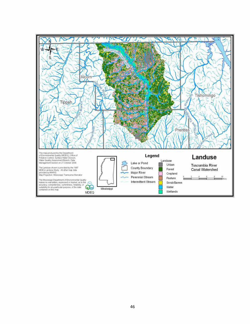
Figure 5.1 Land use in Tuscumbia River Canal Watershed 11
Figure 5.2 Land Use in Tarebreeches Creek-Tuscumbia River Canal Watershed 12
Figure 5.3 Tarebreeches Creek-Tuscumbia River Canal Watershed 13

5
List of Tables
Table 1.1 Tarebreeches Creek-Tuscumbia River Canal Management Action Plan 7
Table 7.1 Water Quality Standards 17
Table 8.1 Funded 319 Project Budget for BMPs 22
Table 8.2 Technical Assistance 22
Table 9.1 Projected Costs for Signage 24
Table 9.2 Projected Costs for Landowner Meeting and Field Days 25
Table 9.3 Projected Costs for Fact Sheets 26
Table 9.4 Projected Costs for Watershed Harmony Puppet Show 26
Table 9.5 Projected Costs for Alcorn County Fair 27
Table 9.6 Projected Costs for Water Bill Mailers 28
Table 9.7 Projected Costs for Presentations 29
Table 9.8 Projected Costs for Radio Advertisements 30
Table 9.9 Projected Costs for Adopt-A-Stream 30
Table 9.10 Total Projected Education Budget 31
Table 9.11 Tarebreeches Creek-Tuscumbia River Canal Watershed
Implementation Plan Total Budget 31
List of Appendices
Appendix A- Plant and Animal Species of Special Concern
Appendix B- Funded 319 Project Proposal
Appendix C- Stressors
Appendix D- Checklist of Watershed Implementation Elements

6
I. EXECUTIVE SUMMARY
Tarebreeches Creek-Tuscumbia River Canal Watershed has been identified as a priority
watershed by the Mississippi Department of Environmental Quality. Tuscumbia River Canal has
three TMDLs; one for Nutrients and Organic Enrichment/Low DO for Bridge and Elam Creeks
and Tuscumbia River Canal (2004), the second for Biological Impairment Due to Sediment in
the Tuscumbia River Canal (2005), and the third for Fecal Coliform For Tuscumbia River Canal
(2000). Tarebreeches Creek is on the 2012 Section 303(d) List f Impaired Water Bodies for
biological impairment. The Mississippi Soil and Water Conservation Commission, Alcorn
County Soil and Water Conservation District and USDA Natural Resources Conservation
Service thought a great impact on water quality could be made in this watershed. MSWCC
submitted a proposal to apply best management practices to address the nutrient loading and
sedimentation issue on agricultural lands. That proposal was selected for funding by MDEQ and
a contract was awarded to MSWCC. Under that contract, MSWCC is required to assemble a
Watershed Implementation Team to address other issues and concerns within the watershed and
write a Watershed Implementation Plan.
The key natural resource problems in this watershed are nutrient loading and
sedimentation. The Watershed Implementation Plan has the goals of reducing the nutrients and
sediment entering the streams and creeks in the watershed, and helping to implement the above
mentioned TMDLs and removing Tarebreeches Creek from the 303(d) List of Impaired Waters.
To help solve this problem, one of the management actions is to implement a 319 water quality
project on the agricultural lands within the watershed. The targeted area for this project is the
cropland and pastureland in Alcorn County that lies within the watershed boundaries. This is a
three year project that began in 2011 and will end in September 2014. The groups that will be
implementing the management action of reducing the sediment loading are the Alcorn County
Soil and Water Conservation District, Natural Resources Conservation Service, and the
Mississippi Soil and Water Conservation Commission. The Alcorn County Soil and Water
Conservation District and the Natural Resources Conservation Service can be contacted at 662-
287-7223 ext. 3 for information and assistance about this management action.

Table 1.1 Tarebreeches Creek-Tuscumbia River Canal Management Action Plan
7
Goal Who What Where When Contacts
Reduce sediment and nutrient
loading, achieve narrative
standards for sediment loading, and
Fish and Wildlife Support
designated use
MSWCC,
USDA NRCS, Alcorn
County Soil and Water
Conservation District
Continue existing programs and projects
related to farmer education, BMP
implementation, and habitat conservation
Entire
watershed
2012-2014 Mark Gilbert, MSWCC
601-354-7645
Paul Lowry, NRCS
662-287-7223 ext. 3
Sandy Mitchell, SWCD
662-287-7223 ext. 3
Local Landowners and
operators
Field Borders
Grade Stabilization Structures
Pasture and Hay Land Planting
Water and Sediment Control Basins
Heavy Use Area Protection
Nutrient Management
Stream Crossings
Tank/Trough
Fencing
Entire
Watershed
2012-2014 Local landowners

8
II. VISION STATEMENT
The vision of the Tarebreeches Creek-Tuscumbia River Canal Watershed Implementation Team
is to improve and/or protect the quality of water in streams and creeks.
III. MISSION STATEMENT
The mission of the Tarebreeches Creek-Tuscumbia River Canal Watershed Implementation
Team is to educate landowners on new and innovative best management practices, land use planning
methods and implement the appropriate Best Management Practices that will result in the enhancement
and conservation of all the natural resources in the watershed.

9
IV. WATERSHED IMPLEMENTATION TEAM Members of the Watershed Implementation Team for the Tarebreeches Creek-Tuscumbia River Canal Watershed
include as follows:
Gladys Scott-Landowner
Steve Wilbanks- Landowner
David Rainey- Landowner/Business Operator
Benjamin Scott- Landowner
Danny Turner- Alcorn County Soil and Water Conservation District Commissioner
Lowell Hinton- Alcorn County Soil and Water Conservation District Deputy Commissioner
Patrick Poindexter- Mississippi State Extension Service
Mark Gilbert- Mississippi Soil & Water Conservation Commission (MSWCC)
Patrick Vowell- Mississippi Soil & Water Conservation Commission (MSWCC)
Gail Spears- Mississippi Soil & Water Conservation Commission (MSWCC)
Andy Whittington- Mississippi Farm Bureau Federation (MFBF)
Daniel Stuart- Mississippi Department of Environmental Quality (MDEQ)
Paul Lowry- Natural Resources Conservation Service (NRCS)
Sandy Mitchell- Alcorn County Soil & Water Conservation District (SWCD)
Shane Stocks- United States Geological Survey (USGS)
Dr. John Ramirez-Avila- Mississippi State University (MSU)
Janet Chapman- Mississippi Department of Environmental Quality (MDEQ)
Justin Presson- Natural Resources Conservation Service(NRCS)

10
V. WATERSHED DESCRIPTION
The Tuscumbia River Canal watershed is approximately 204,311 acres. The land uses for the
Tuscumbia River Canal Watershed include 33,293 acres of pastureland (16.3%), 72,214 acres of
forestlands (35.3%), 31,795 acres of cropland (15.6%), and 67,009 acres of urban and other (all together
32.8%). Figure 5.1 shows the land uses in the Tuscumbia River Canal watershed. The targeted area of
this watershed is the Tarebreeches Creek Subwatershed (Figure 5.2).
Tarebreeches Creek-Tuscumbia River Canal is located in the north to northwestern portion of
Alcorn County, Mississippi (Figure 5.3). There are 16,721 acres located within the watershed
boundaries. This watershed is located in a rural area with a population of about 300 people within its
boundaries. The community of Gift is located in this watershed. Economic conditions that influence
this watershed include farming which is affected by commodity prices and costs in planting and
harvesting. There have been no significant changes in land use in this watershed in the last 20 years.
The soils in the watershed include Arkabutla, Mantachie and Rosebloom series soils. The
geology of the watershed is Ripley Formation of the Late Cretaceous Epoch. Tarebreeches Creek-
Tuscumbia River Canal watershed is located in the Northern Hilly Gulf Coastal Plain ecoregion. Some
of the areas alongside the Tuscumbia River Canal in the watershed are wetlands.
Other named water bodies in the watershed include Little Cane Creek and Hughes Break. The
Tuscumbia Wildlife Management Area is located within this watershed.

11
Figure 5.1 Land Use in Tuscumbia River Canal.

12
Figure 5.2 Land Use in Tarebreeches Creek-Tuscumbia River Canal.

13
Figure 5.3 Tarebreeches Creek-Tuscumbia River Canal Creek Watershed.

14
VI. STAKEHOLDER INTERESTS
The stakeholders in this watershed want to conserve and preserve the soil, water, and wildlife
habitat. Stakeholders in the watershed want to restore the watershed creeks and streams to a state of
good water quality. This can be done by reducing runoff (stopping erosion and loss of topsoil) and
improving habitat for fish and wildlife. Stakeholders desire to use the natural resources wisely, eliminate
snags and debris (through dredging or other alternatives), stop people from littering and provide beaver
control. Also, there are issues where people target practice from bridges endangering cattle and other
livestock nearby. The stakeholders believe all the interests are tied together. The snags and debris are
coming from two different sources. Storm damage to woody areas cause log and brush debris to get into
the streams. Also, people toss household trash and old appliances from bridges into the streams and
creeks. This debris causes large snags that retard the flow causing flooding. Once the flood waters
recede the topsoil is washed away taking nutrients and chemicals with it. This increases the potential of
starting head cuts and gullies while leaving debris in pastures and on cropland. Therefore, the
stakeholders think stopping the littering would help resolve many of the snag and debris issues in the
streams and creeks. This would, in turn, help reduce the sediment and nutrients entering the streams.
Landowners are concerned that sediment and other contaminants will affect the water quality in the
watershed. Beaver control has always been an issue, but recently the beaver dams have caused flooding
of croplands. Due to this flooding, some of the farmers will lose parts of some fields that they farm.
Also, wild hogs have become a problem in areas around this watershed and the stakeholders think it is
only a matter of time before they are a nuisance here, too. The hogs uproot the fields and forest land and
cause devastation to crops.

15
VII. Water Resources A. History of Activity in the Watershed
The primary players in restoration and /or conservation efforts in the Tarebreeches Creek-
Tuscumbia River Canal Watershed are the Natural Resources Conservation Service, Alcorn County Soil
and Water Conservation District and the Mississippi Soil and Water Conservation Commission. Local
landowners and operators will play a major role in the restoration and conservation of the natural
resources in this watershed by installing best management practices on their land. There have been
several programs that have been utilized by landowners in the watershed in past years. These programs
include the Environmental Quality Incentive Program (EQIP), Wildlife Habitat Incentives Program
(WHIP), Conservation Reserve Program (CRP), Forestry Incentives Program (FIP), Emergency
Watershed Program (EWP), Water Quality Incentive Program (WQIP), Hold Our Topsoil (HOT) and
the Agricultural Conservation Program (ACP). These programs have helped many landowners apply
conservation on the ground while reducing soil loss, enhancing wildlife habitat, enhancing water quality,
increasing water quantity, increasing tree production and promoting conservation education.
The Tarebreeches Creek-Tuscumbia River Canal Watershed was selected as a priority watershed
by the Mississippi Department of Environmental Quality. As the management agency for Agricultural
Nonpoint Source Pollution in Mississippi, the Mississippi Soil and Water Conservation Commission
(MSWCC) determined that the Tarebreeches Creek-Tuscumbia River Canal Watershed would be a good
candidate for restoration. After meetings with local landowners, Alcorn County Soil and Water
Conservation District (SWCD) commissioners and staff and Natural Resources Conservation Service
(NRCS) employees that work in this area, MSWCC felt there was enough interest in the watershed that a
measurable difference could be shown, and submitted a proposal to the Mississippi Department of
Environmental Quality (MDEQ). Through a collaborative effort between Alcorn County SWCD,
NRCS, MDEQ and MSWCC, the team members for the Watershed Implementation Team were
assembled. At this point in time, there has been no process discussed to modify this team.

16
B. Wildlife and Fisheries
There are important recreational species located throughout the watershed. These species
include deer, turkey, bass, catfish, bream, rabbits, squirrel, and raccoon. The list of plants and animals
of special concern are included as Appendix A. There are no animals and plants that are threatened or
endangered in this watershed.
C. Designated Use Classifications and Water Quality
Standards
The designated beneficial uses for the Tarebreeches Creek and Tuscumbia River Canal and the
waterbodies included in the watershed are aquatic life support and secondary contact. The water use
classification for the listed segments of Tarebreeches Creek and Tuscumbia River Canal is fish and
wildlife support according to the 2002 Water Quality Criteria for Intrastate, Interstate and Coastal
Waters. There are no numeric water quality standards for sediment applicable at this time. The
acceptable reference yields range for stable streams within HUC 08010207 established by EPA Region
IV is .000757 to .00459 tons per acre per day at the effective discharge. It is expected that all values
within this range will result in attainment of water quality standards. It is estimated the typical range for
unstable streams in HUC 08010207 is .00151 to .0761 tons per acre per day at the effective discharge.
This range is representative of the load that would be expected from the Tarebreeches Creek-Tuscumbia
River Canal Watershed. The aquatic life use attainment threshold scores associated with the
Tarebreeches Creek-Tuscumbia River Canal Watershed is as follows: Tuscumbia River Canal- 63.86.
The reference MBISQ score for the Bioregion is 82.27.
17
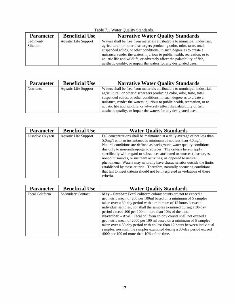
Table 7.1 Water Quality Standards.
Parameter Beneficial Use Narrative Water Quality Standards Sediment/
Siltation
Aquatic Life Support Waters shall be free from materials attributable to municipal, industrial,
agricultural, or other dischargers producing color, odor, taste, total
suspended solids, or other conditions, in such degree as to create a
nuisance, render the waters injurious to public health, recreation, or to
aquatic life and wildlife, or adversely affect the palatability of fish,
aesthetic quality, or impair the waters for any designated uses.
Parameter Beneficial Use Narrative Water Quality Standards
Nutrients Aquatic Life Support Waters shall be free from materials attributable to municipal, industrial,
agricultural, or other dischargers producing color, odor, taste, total
suspended solids, or other conditions, in such degree as to create a
nuisance, render the waters injurious to public health, recreation, or to
aquatic life and wildlife, or adversely affect the palatability of fish,
aesthetic quality, or impair the waters for any designated uses.
Parameter Beneficial Use Water Quality Standards
Dissolve Oxygen Aquatic Life Support DO concentrations shall be maintained at a daily average of not less than
5.0mg/l with an instantaneous minimum of not less than 4.0mg/l.
Natural conditions are defined as background water quality conditions
due only to non-anthropogenic sources. The criteria herein apply
specifically with regard to substances attributed to sources (discharges,
nonpoint sources, or instream activities) as opposed to natural
phenomena. Waters may naturally have characteristics outside the limits
established by these criteria. Therefore, naturally occurring conditions
that fail to meet criteria should not be interpreted as violations of these
criteria.
Parameter Beneficial Use Water Quality Standards
Fecal Coliform Secondary Contact May - October: Fecal coliform colony counts are not to exceed a
geometric mean of 200 per 100ml based on a minimum of 5 samples
taken over a 30-day period with a minimum of 12 hours between
individual samples, nor shall the samples examined during a 30-day
period exceed 400 per 100ml more than 10% of the time.
November – April: Fecal coliform colony counts shall not exceed a
geometric mean of 2000 per 100 ml based on a minimum of 5 samples
taken over a 30-day period with no less than 12 hours between individual
samples, nor shall the samples examined during a 30-day period exceed
4000 per 100 ml more than 10% of the time.

18
D. Current Status of Water Bodies in the Watershed
Waterbodies in the Tarebreeches Creek-Tuscumbia River Canal watershed are included on
Mississippi’s 303(d) list of impaired waters and they are as follows:
Tuscumbia River Canal- listed for Sediment, Low DO/Organic Enrichment, and Nutrients.
E. TMDLs
The Tarebreeches Creek-Tuscumbia River Canal Watershed is located in Alcorn County,
Mississippi. The watershed ID number is 0503, and the Hydrologic Unit Code (HUC) code for the
watershed is 08010207. This particular watershed is located in the Tuscumbia River Canal Watershed.
The streams in Tuscumbia River Canal Watershed are biologically impaired due to sediment/siltation,
low dissolved oxygen (DO)/ organic enrichment, and nutrients.
There have been two TMDLs developed for Tuscumbia River Canal. The first TMDL is for
biological impairment due to Sediment. The second TMDL is for biological impairment due to
Nutrients and Low DO/Organic Enrichment.
The recommended load reduction for sediment is a narrative criteria because at this time
Mississippi does not have numeric criteria for sediment. Also, due to sediment data being unavailable
and insufficient, the sediment range used for the TMDL were obtained from those values of unstable
streams in the level III ecoregion. This range is from .00151 to .0761 tons per acre per day at the
effective discharge, therefore, a reduction in the sediment loading is recommended to bring those
unstable streams back to yields that are acceptable for stable streams in the ecoregion. The
recommended management actions to reduce the loading to the streams are stream bank and riparian
buffer zones restoration and any other sediment reduction BMPs, especially for the road crossings,
agricultural activities, and construction activities.
The recommended load reduction from the nutrients, low DO and organic enrichment TMDL
includes a 77% reduction of phosphorous and an 8.7 % reduction Total Nitrogen (TN) from nonpoint
sources. The management actions for this load reduction include riparian buffer zone restoration and
other nutrient reduction BMPs. Implementation of these BMP activities should reduce nutrient loading
to the streams that will result in attainment of applicable water quality standards.

19
VIII. WATERSHED MANAGEMENT
ACTIONS
Agricultural Best Management Practices
A. Sediment and Nutrient BMPs
1. Stakeholder Interests
The major interests of the stakeholders are the sediment and nutrient loadings to Tarebreeches
Creek and the Tuscumbia River Canal in the watershed. These are the reasons these creeks are impaired
and have TMDLs or are listed on Mississippi’s 303(d) List of Impaired Waters.
2. Goals/Objectives
The goal and objective is to reduce the sediment and nutrient loading coming from agricultural
lands and bring the creeks back from unstable stream levels to stable stream levels. Doing this will help
implement the TMDLs for these creeks and may remove Tarebreeches from the 303 (d) list.
3. Management Actions
The management action that will be taken to address sediment and nutrient loading is the
installation of agricultural BMPs that pertain to sediment and nutrients. These BMPs include but are not
limited to:
Field Borders,
Grade Stabilization Structures,
Pasture and Hay Land Planting,
Nutrient Management,
Water and Sediment Control Basins,
Fencing,
Stream Crossings,
Heavy Use Area Protection, and
Tank/Troughs.

20
These BMPs will be installed by cooperating landowners in the watershed. The program that
these BMPS will be installed under is the MSWCC cost-share program. The Natural Resources
Conservation Service (NRCS) will provide the technical/planning assistance for this project. Most of
the BMPs that will be installed are permanent structures and must be maintained by the landowner for a
period of 10 years. NRCS and Alcorn County Soil and Water District employees identified landowners
in the watershed that had agricultural land using maps provided by the Mississippi Department of
Environmental Quality.
4. Project Tracking/Assessment of Progress
The Tarebreeches Creek-Tuscumbia River Canal 319 project began in 2011 and is scheduled to
end September 2014. The milestones for the Tarebreeches Creek-Tuscumbia River Canal Watershed
319 project are listed below:
1. Assist Natural Resources Conservation Service (NRCS), United States Geological Survey
(USGS), and the Alcorn County Soil and Water Conservation District (SWCD), with
assistance from Mississippi Department of Environmental Quality (MDEQ), in the
development of a Watershed Implementation Team (WIT).
2. Develop a Watershed Implementation Plan (WIP) consistent with MDEQ guidance and
assistance from the WIT.
3. Assist in the development and implementation of a watershed monitoring plan for the project.
4. Present a draft WIP to MDEQ and the Tarebreeches Watershed Implementation Team for review and
comments.
5. Determine through intensive surveys, priority areas that are contributing significant pollutant
loads in the watershed.
6. Inform the public, landowners, and other stakeholders within the project area about the project
and secure commitments from priority landowners and others willing to participate in the
project.
7. Notify MDEQ project officer, in a timely manner, of all project visits/ inspections/ field days/
and any other public meetings so that the project officer may have an opportunity to attend.
8. Develop plans for Best Management Practices (BMPs) in accordance with approved WIP.

21
9. Assist landowners and operators in the installation of appropriate BMPs and collect
before and after soil loss and GPS coordinates each installed BMP and incorporate into a GIS
format.
10. Establish at least two (2) demonstration farms to inform the public about BMPs.
11. Provide a least two (2) informational field days/tours to inform the public about the
benefits of the project.
12. Develop and distribute no fewer than 1,000 informational fact sheets highlighting the
benefits derived from the project.
13. Publish no fewer than 4 articles about the project in newsletters and local newspapers.
14. Erect no fewer than 20 project roadside signs where water quality practices are installed
in the project.
15. Document pre-existing site conditions and improvements by conducting before and after
photo documentation.
16. Assist the MDEQ project officer in conducting inspections during construction.
17. Make project presentations as requested by MDEQ.
18. Secure maintenance agreements from cooperators/landowners in accordance with
MSWCC state cost-share guidelines.
19. Submit bi-annual reports by every September 25th
and March 25th
of each year showing
status of tasks and start/completion dates of each task.
20. Submit a final report to MDEQ.
5. Desired Results/Benefits
The desired benefit of this project will be the reduction of sediment and nutrient loading to levels
that are considered to be acceptable and remove the impaired segments of Tarebreeches Creek from the
303 (d) list and will help implement the TMDLs for the subwatershed in the Tuscumbia River Canal
watershed.

22
6. Roles/Responsibilities
There are several different groups with responsibilities in this watershed. MSWCC has the
responsibility and role of administering the 319 project. The Alcorn County Soil and Water
Conservation District and the local NRCS staff have the role of technical assistance. The landowners
have the responsibility of implementation of BMPs in the project area. The Tarebreeches Creek
Watershed Implementation Team has the role of helping gather all the information needed to write the
Watershed Implementation Plan. MSWCC also has the responsibility of compiling all the information
and writing the initial plan for the watershed. Other programs that are available to landowners in the
watershed include EQIP, CRP, and WHIP. Under these three programs, there has been $194,897 spent
over the last three years with another $190,000 projected to be spent over the next three years.
7. Budget
The table below shows a list of potential Best Management Practices to be installed with the 319
grant.
Table 8.1 Funded 319 Project Budget for BMPs.
Practice Area Affected BMP Cost BMP Total Field Borders 9 acres $250/ac $2,250
Grade Stabilization Structure 7 structures $6,500 ea $45,000
Pasture and Hay Land Planting 175 acres $200/ac $35,000
Water and Sediment Control Basin 4 structures $10,000 ea $40,000
Nutrient Management 2,000 acres $103.8/ac $206,167
Tank/Trough 10 each $2,500 ea $25,000
Stream Crossing 4 each $15,000 ea $60,000
Heavy Use Area Protection 6,250 sq feet $12/sq ft $75,000
Fencing 2,500 feet $1.30/ft $3,250
Total $491,667
Table 8.2 Technical Assistance
Item Cost Technical Assistance $41,667
Total $41,667

23
IX. EDUCATION/OUTREACH ACTIVITIES
A. Educational Activities to be Implemented
The overall objective of community education in the Tarebreeches Creek-Tuscumbia River
Canal watershed is to develop an atmosphere that promotes sustained, long-term protection and
improvement of aquatic resources in the watershed. Specific objectives of education efforts in the
watershed include the following:
Increase public awareness of the value of clean water.
Increase public awareness of agricultural runoff and encourage behaviors that will reduce
levels of sediments and nutrients in the watershed by education, watershed
characterization and stewardship opportunities.
Increase public awareness of how BMPs can be used to reduce negative water quality and
habitat effects.
Increase public awareness of the long term environmental and economic advantages of
protecting and improving water quality and habitat in the Tarebreeches Creek-Tuscumbia
River Canal watershed.
1. Signage
Signs identifying the BMPs that have been installed will be erected throughout the
watershed upon permission of landowners.
Primary partners- Mississippi Soil and Water Conservation Commission, Mississippi Department of
Environmental Quality, Alcorn County Soil and Water Conservation District, Natural Resources
Conservation Service, and Environmental Protection Agency.

24
a. Indicators
There will be field days held to show other landowners and the interested public the
BMPs installed. Participants will be counted at these field days. Traffic through the watershed
cannot be documented, but some areas are along a heavily traveled state highway.
b. Schedule
The BMP signs will be erected as practices are completed and/or requested by the
landowners throughout the life of the project.
c. Budget
Table 9.1 Projected Costs for Signage.
Item Unit Cost Total Cost
Signs 20 $100.00 $2,000.00
Total $2,000.00
2. Landowner Meeting and Field Days
There will be a landowner meeting held to inform landowners in the watershed about the project
and what BMPs will be available for implementation on their land. Also, there will be at least two
field days held to highlight the BMPs that have been installed during the project period. This will
allow other landowners and the interested public to view some of the practices that are being
installed to benefit water quality in the watershed.
Primary partners- Mississippi Soil and Water Conservation Commission, Mississippi
Department of Environmental Quality, Alcorn County Soil and Water Conservation District, Natural
Resources Conservation Service, and Environmental Protection Agency
a. Indicators
Attendance at the landowner meeting and the field days will be documented and reported
to MDEQ. The number of individuals who install BMPs as a result of the field days will also be
documented.

25
b. Schedule
Field days in the watershed will take place in 2012-2014.
c. Budget
Table 9.2 Projected Costs for Landowner Meeting and Field Days.
Item Units Cost Total Cost
Event Flyers 300 .60/each $180.00
Mailing/Delivery 300 .45/each $135.00
Miscellaneous (Landowner
meeting, field days, supplies)
3 $1,920.67/each $5,762.01
Total $6,077.01
3. Fact Sheets
A fact sheet will be developed at the end of the project. This fact sheet will contain
information about the watershed, the number and type of BMPs that were installed, the number of
tons of soil being saved, and the number of acres impacted by the BMPs.
Primary Partners- Mississippi Soil and Water Conservation Commission, Alcorn County Soil
and Water Conservation District, and Natural Resources Conservation Service.
a. Indicators
1,000 fact sheets will be designed and distributed. These fact sheets will be handed out at
the final field day and will also be available in the district offices.
b. Schedule
The fact sheet will be developed once all BMPs are in place to get a total tons of soil
saved and the correct number of BMPs installed.

26
c. Budget
Table 9.3 Projected Costs for Fact Sheets.
Item Unit Cost Total Cost
Printing 1,000 1.00/each $1,000.00
Total $1,000.00
4. Watershed Harmony Puppet Show
Watershed Harmony is a musical puppet performance aligning with the fourth and fifth grade
Mississippi Framework and National Science Standards. Audiences of all ages will delight in
environmental stewardship through this toe tapping musical. Performances are not only enjoyed by
school groups, but also by adults attending teacher workshops, civic clubs, and conferences. This
program serves to inform, excite, and enlist the help of citizens in an ongoing effort to promote
water quality in their communities.
Primary Partners- Mississippi Department of Environmental Quality and Bayou Town
Productions.
a. Indicators
The number of participants will be documented and submitted to MDEQ.
b. Schedule
Watershed Harmony will be presented before August 2014.
c. Budget
Table 9.4 Projected Costs for Watershed Harmony Puppet Show
Item Unit Cost Total Cost
Watershed Harmony Puppet Show 1 show $1,000.00 $1,000.00
Total $1,000.00

27
5. Alcorn County Fair
A booth will be set up at the fair with information about the project with pictures of BMPs within
the watershed and other educational materials about nonpoint source pollution and the Tarebreeches
319 project. A coloring contest will be held during the fair for 2 age groups, 0-5 years old and 6-8
years old. During the 2 days the booth is set up, there will be awards given every hour to the
coloring contest winners. Also, Sam E Soil will be making special appearances throughout the time
the booth is set up.
Primary partners- Mississippi Soil and Water Conservation Commission, Mississippi
Department of Environmental Quality, and Alcorn County Soil and Water Conservation District.
a. Indicators
The number of brochures that are handed out to adults while the children are participating
in the coloring contest will be documented. The number of children who participate in the coloring
contest will be documented and the number of coloring books about Sam E Soil given out will be
documented.
b. Schedule
The exhibit will be at the fair for 3 consecutive years.
c. Budget
Table 9.5 Projected Costs for Fair Exhibit.
Item Units Cost Total Cost
Brochures 3,000 .65/each $1,950.00
Coloring Books 6,000 .38/each $2,280.00
Litter Bags 2,500 .42/each $1,050.00
Gift Cards 48 $20.00/each $960.00
Total $6,240.00

28
6. Water Bill Mailers
A flyer will be designed and mailed out to the homes in the Tarebreeches watershed. This flyer
will inform them of ways they can help improve water quality in the watershed. This will be mailed
out with their monthly water bill.
Primary partners- Mississippi Soil and Water Conservation Commission, Mississippi
Department of Environmental Quality, and Alcorn County Soil and Water Conservation District.
a. Indicators
The number of flyers sent out will be documented.
b. Schedule
This flyers will be mailed before August 2014.
c. Budget
Table 9.6 Projected Costs for Water Bill Mailers.
Item Units Cost Total Cost
Mailing 500 .44/each $225.00
Envelopes 500 .10/each $50.00
Flyer 500 .65/each $325.00
Total $600.00

29
7. Presentations
Presentations relating to water quality will be made to civic organizations. These presentations
will inform individuals about how they can improve water quality and reduce nonpoint source
pollution.
Primary partners- Mississippi Soil and Water Conservation Commission, Mississippi Department of
Environmental Quality, and Alcorn County Soil and Water Conservation District.
a. Indicators
The number of people in attendance will be documented.
b. Schedule
These presentations will be made before August 2014.
c. Budget
Table 9.7 Projected Budget for Presentations.
Item Units Cost Total Cost
Miscellaneous 3 $50.00/each $150.00
Total $150.00
8. Radio Advertisements
Radio advertisements will be run on the local radio station to inform people about water quality
and nonpoint source pollution. Each spot will run 5 times a days for 2 weeks.
Primary partners- Mississippi Soil and Water Conservation Commission, Mississippi Department of
Environmental Quality, and Alcorn County Soil and Water Conservation District.
a. Indicators
The number of radio ads run and produced will be recorded.
b. Schedule
The ads will run before August 2014.

30
c. Budget
Table 9.8 Projected Costs for Radio Advertisements.
Item Units Cost Total Cost
Ads 3 $200.00/each $600.00
Total $600.00
9. Adopt-A-Stream
Adopt-A-Stream is a program that promotes environmental stewardship through training
workshops, outdoor field activities, and by introducing participants to watershed action projects.
One and two-day workshops inform participants about watershed topics such as stream health,
stream ecology, aquatic life and water chemistry.
Primary Partners- Mississippi Department of Environmental Quality and Mississippi Wildlife
Federation.
a. Indicators
The number of participants and the number of participants that carry on the adoption
activities will be documented.
b. Schedule
At least one event will take place before September 30, 2014.
c. Budget
Table 9.9 Projected Costs for Adopt-A-Stream Workshop.
Item Unit Cost Total
Cost
Adopt A Stream
Workshop
1 day workshop $1,000.00 $1,000.00
Total $1,000.00

31
10. Total Projected Cost of Education/Outreach Activities
Table 9.10 Total Projected Education Budget
Item Unit Cost Total Cost
Signage 20 $100.00 $2,000.00
Landowner Meeting and Field Days 3 $2,025.67 $6,077.01
Fact Sheets 1,000 $1.00 $1,000.00
Watershed Harmony Puppet Show 1 $1000.00 $1,000.00
Alcorn County Fair 3 $2,080.00 $6,240.00
Water Bill Mailers 1 $600.00 $600.00
Presentations 3 $50.00 $150.00
Radio Ads 3 $200.00 $600.00
Adopt-A-Stream 1 $1,000.00 $1,000.00
Total $18,667.01
11. Total Budget for Tarebreeches Creek-Tuscumbia River Canal Watershed
Implementation Plan
Table 9.11 Tarebreeches Creek-Tuscumbia River Canal Watershed Implementation Plan Total Budget
Item Cost BMPs $491,667
Technical Assistance $41,667
Education/Outreach $18,667.01
Total $552,001.01

32
X. EVALUATION
A. Plan Evaluation Procedure
This watershed implementation plan will be evaluated and revised every three to five years or on
an as needed basis. The evaluation of this plan will be organized by the Tarebreeches Creek-
Tuscumbia River Canal Watershed Implementation Team. At that time, the WIT will develop a
detailed schedule for review and revision of this watershed implementation plan. The WIT members
will be responsible for notifying their stakeholders of the opportunity to propose changes to the
watershed implementation plan. One month will be allowed for notification of stakeholders.
The plan will be evaluated by the team, or their designee, and any interested stakeholders. One
month will be allowed for evaluation and submittal of comments. Therefore, comments will be due
two months after the evaluation procedure is initiated. The plan will be evaluated in two ways. First,
to determine if the plan goals have been achieved, and second, to determine if it reflects the current
condition of the watershed, state of science, and issues in the watershed.
B. Implementation Evaluation Strategy
1. The following measures and indicators of progress will be utilized to track the
success of this plan by MSWCC:
Before and after photo documentation on a representative sample of the BMPs
installed,
Before and after soil loss collection on each BMP installed, and
An R5 Load estimation Model Field Data Entry Sheet completed on each BMP
installed,
Establishment of two demonstration farms that will be used to inform the public
about best management practice systems, and
Informational fact sheets will be distributed that highlight the benefits derived
through the installation of Best Management Practices.
2. MDEQ will be responsible for any monitoring at the conclusion of the project to
determine the pollutant reductions achieved by the application of Best Management Practices in the
watershed.
33
XI. PLAN REVISION
A. Plan Revision Procedure After evaluation, MDEQ will prepare a revised watershed implementation plan incorporating
the changes requested by the reviewers. At this point it may be necessary to call a meeting to
reconcile any conflicting comments or requests for change.
If the evaluation criteria are all being met in Tarebreeches Creek-Tuscumbia River Canal surface
waters, the watershed implementation plan will be revised to address a different restoration issue or
issues, or to protect the water quality of the watershed. If the evaluation criteria for the watershed are
not being met, the approach for restoring Tarebreeches Creek-Tuscumbia River Canal watershed
will be revised based on the knowledge that has been gained since 2011.
The draft watershed implementation plan will be submitted to the Implementation Team, and all
others who submitted comments. Within two weeks of receiving the draft watershed implementation
plan, the Implementation Team will notify their stakeholders of the availability of the revised
watershed implementation plan for stakeholder review. One month will be allowed for review of the
draft. Comments will be due at the end of this review period.
Within a month after the comments on the draft watershed implementation plan are received, the
DRAFT watershed implementation plan will be submitted to the Implementation Team for review
and approval. After the DRAFT watershed implementation plan has been approved, the
Implementation Team will notify their stakeholders of the completion and availability of the plan for
use as a guide to watershed restoration and protection activities.

34
XII. RESOURCES MDEQ. 2005. Total Maximum Daily Load Tuscumbia River Canal Watershed for Biological
Impairment Due to Sediment. Mississippi Department of Environmental Quality. Jackson,
Mississippi.
MDEQ 2009. Total Maximum Daily Load Nutrients and Organic Enrichment/Low DO for Bridge
and Elam Creek and Tuscumbia river Canal, Mississippi Department of Environmental Quality.
Jackson, Mississippi.
MDEQ 2000. Fecal Coliform TMDL For Tuscumbia River Canal North Independent Basin, Alcorn
and Prentiss Counties, Mississippi, Mississippi Department of Environmental Quality. Jackson,
Mississippi
"Natural Heritage Inventory: Search Animal Database." Mississippi Museum of Natural Science.
<http://www.mdwfp.com/museum/html/Research/query_animals.asp>
"Natural Heritage Inventory: Search Plant Database." Mississippi Museum of Natural Science.
<http://www.mdwfp.com/museum/html/Research/query_plants.asp>
USDA. SCS. 1971. Soil Survey of Alcorn County, Mississippi.

35
Appendix A
Plant and Animal Species of Special
Concern

36
Animals of Special Concern in Alcorn County Scientific Name Common Name
AINOPHILA AESTIVALIS BACHMAN’S SPARROW
CYPRINELLA WHIPPLEI STEELCOLOR SHINER
ETHEOSTOMA ZONISTIUM BANDFIN DARTER
PLEUROBEMA BEADLEIANUM MISSISSIPPI PIGTOE
PROCAMBARUS ABLUSUS A CRAYFISH
PSEUDOTRITON RUBER RED SALAMANDER
ZAPUS HUDSONIUS MEADOW JUMPING MOUSE
Plant Species of Special Concern in Alcorn County Scientific Name Common Name
CHELONE GLABRA WHITE TURTLEHEAD
PLATANTHERA INTEGRILABIA WHITE FRINGELESS ORCHID
PLATANTHERA PERAMOENA PURPLE FRINGELESS ORCHID
SALVIA URTICIFOLIA NETTLE-LEAF SAGE
SILENE OVATA OVATE CATCHFLY

37
Appendix B
Funded 319 Project Proposal
38
PROJECT TITLE:
Tarebreeches Creek-Tuscumbia River Canal Watershed Nonpoint Source Pollution Project
PROJECT ABSTRACT:
This project will be located in the north central portion of Alcorn County in Mississippi.
The objectives of this project will be:
To improve water quality and protect high quality waters through the implementation of selected
BMPs in targeted areas.
To apply Best Management Practices (BMPs) to agricultural lands in the project area so as to
reach the desired outcome of reduced nutrient loads entering streams in the watershed.
To inform and educate the public about Best Management Practices that benefit water quality.
The project cost is $550,001. Of this amount, $330,000 in 319 funds are requested with the balance of
$220,001 to be supplied as match.
LEAD ORGANIZATION:
Mississippi Soil and Water Conservation Commission
Mark Gilbert, Project Manager
P.O. Box 23005
Jackson, MS 39225-3005
Phone: (601) 354-7645
Fax: (601) 354-6628
e-mail: [email protected]
COOPERATING AGENCIES AND ORGANIZATIONS:
Alcorn County Soil and Water Conservation District; USDA Natural Resources Conservation Service;
Mississippi Department of Environmental Quality

39
GRANT ADMINISTRATOR:
Mark E. Gilbert, Environmental Administrator
MS Soil & Water Conservation Commission
P.O. Box 23005
Jackson, MS 39225-3005
Phone: (601) 354-7645
(601) 540-4210 (cell)
Fax: (601) 354-6628
e-mail: [email protected]
PROJECT LOCATION:
Tarebreeches Creek-Tuscumbia River Canal Watershed (08010207-0503)
(see attachment 1 for maps depicting the location and land use for the watershed)
PROJECT OBJECTIVE:
The water quality impairment to be addressed by this project is nutrient loading. Subsequent biological
monitoring has concluded the streams are impaired due to biological impairment. The stressor
identification process pointed to organic enrichment and nutrient enrichment as probable primary
stressors. The Mississippi Department of Environmental Quality (MDEQ) has placed segment
MS203TE, MS203BE, and MS204E of Tuscumbia River Canal, Bridge Creek, and Elam Creek,
respectively, on the 2008 Section 303(d) List of Waterbodies as monitored water body segments, due to
nutrients and organic enrichment/low DO. The State’s 2008 303(d) list of monitored water bodies lists
the designated use of Tuscumbia River Canal as fish and wildlife support. MDEQ has developed a
TMDL for the listed segment of Tuscumbia River Canal. The TMDL model indicates violation of the
preliminary target numbers allowable to meet standards for its designated use. The existing condition
load was based on a special study conducted in 2006 in and around Corinth and resulted in findings of
an overall 77% reduction in nonpoint phosphorous loads and an 8.7% reduction in TN from nonpoint
sources. (a copy of the TMDL is attached)
Another objective of this project will be to reduce soil loss on pasture land in the watershed. BMPs
listed on the following page will not only reduce nutrients and pathogens but will also reduce the
amount of sediment entering Tuscumbia River Canal from pasture land in the watershed.
PROJECT DESCRIPTION:
This project will implement selected Best Management Practices (BMPs) on targeted areas in the
Tuscumbia River Canal Watershed that will result in reduced pollutant loadings from agricultural
nonpoint sources. The targeted area within this watershed will be the Tarebreeches Creek Watershed.
The main water quality problem to be addressed by this project is nutrients from agricultural nonpoint
sources. Of primary concern are animal waste runoff and the animal access to streams from cattle
operations in the watershed. Also, soils in the watershed are very erosive, with sheet and gully erosion
occurring on sloping hay land and pastureland. Erosion is occurring from pasture and hay land in the
project area at the rate of 8-10 tons per acre per year. Nutrients and pathogens from animal waste as

40
well as sediment contained in runoff are entering the Tuscumbia River Canal and its tributaries causing
degradation of the resource base.
The erosion of the soil resource base removes nutrients, reduces water holding capacity, undermines
plant rooting systems, reduces the soil’s organic matter content, reduces soil tilth and degrades water
quality within the project area.
The Tuscumbia River Canal Watershed is approximately 204,311 acres. The watershed is
predominately rural. The current land uses in the Tuscumbia River Canal Watershed include 31,795
acres of cropland, 33,293 acres of pasture land, 72,214 acres of timber land, 18,380 acres of urban land,
22,143 aces of barren land, 23,156 acres of wetlands and 3,330 acres of water. This project will target
the Tarebreeches Creek-Tuscumbia River Canal Watershed which is approximately 16,721 acres.
Within this watershed, the project will be implemented on an area of about 9,240 acres that contains
about 2,000 acres of pasture land.
This project will be implemented in three phases. Phase 1 will consist of analyzing existing
assessment data, determining target areas within the watershed where the stressors are causing the
greatest damage and if the application of needed Best Management Practices will yield a beneficial
reduction in pollutant loadings. Education and outreach activities will also be conducted during this
phase to inform landowners in the watershed about the objectives of the project. The Mississippi Soil
and Water Conservation Commission (MSWCC) will cooperate with the Alcorn County Soil and Water
Conservation Districts in identifying the appropriate Best Management Practices for targeted areas in the
watershed and educating landowners as to the need for their participation.
Phase 2 will consist of (based upon the finding of phase 1) the application of best management practices
on targeted areas in the watershed that will result in desired pollutant load reductions. The Mississippi
Soil and Water Conservation Commission will accomplish this through its water quality cost share
program. In this project, records will be kept at both the state level and local level so as to determine the
progress being made in carrying the project out and the benefits that are being received as related to the
improvement of water quality within the project. During the planning process with participants, the
amount of soil loss from the area to be treated with a particular BMP will be determined and recorded.
The amount of soil saved as a result of applying the BMP will also be determined and recorded.
Additional information will be collected on each BMP installed in the project that will be provided to
MDEQ and used to calculate the pollutant load reduction for each BMP installed. This information will
indicate the project effectiveness in reducing pollutant loadings. Participants in the project will be
required to maintain BMPs for a period of up to ten years after installation.
Additional education and outreach efforts will be conducting during this phase to inform and educate the
public about Best Management Practices that benefit water quality. This will be accomplished by the
following:
Establish at least 2 demonstration farms to inform the public about best management systems.
Conduct at least 2 field day/tours during the life of the project.
Prepare and distribute at least 1,000 fact sheets highlighting the benefits derived from the project.
Publish at least 4 articles about the project in newsletters and local newspapers.
Erect at least 20 project roadside signs that designate where water quality practices are in progress or
have been completed.

41
To address the above stated water quality problems, Best Management Practices (BMPs) will be
installed on agricultural lands in the project area. Potential BMPs to be installed include but are not
limited to:
9 acres of field borders
7 grade stabilization structures
175 acres of pasture & hay land planting
4 water and sediment control basins
2,000 acres of nutrient management
10 watering troughs or tanks
4 stream crossings
6,250 square feet of heavy use area protection
2,500 feet of fencing
Phase 3 will consist of post BMP monitoring to determine the pollutant load reductions achieved by the
application of Best Management Practices. The MSWCC will coordinate with the MDEQ in conducting
these activities.

42
MILESTONES:
1. Sign grant contract with MS Department of Environmental Quality. (Month 0)
2. Determine priority areas that are contributing significant loads in the watershed. (Month 1)
3. Issue policies and procedures for implementing the project to the SWCD office. (Month 1)
4. Meet with the board of SWCD commissioners to get their understanding of their responsibilities
and participation. (Month 2)
5. Provide training to district staff. (Month 2-3)
6. Assist in establishing an evaluation system in conjunction with the MS Department of
Environmental Quality to indicate the benefits of the project. (Month 2-3)
7. Conduct a landowner meeting to inform potential participants about the project. (Month 3)
8. Secure commitments from several landowners and operators who are willing to participate in the
project. (Month 3-4)
9. Assist participants in developing a conservation plan and applying best management practices
(Month 4-12)
10. Establish at least demonstration farm (Month 4-12)
11. Document pre-existing site conditions. (Month 2-12) (Before and after photo documentation will
be conducted).
12. Accelerate conservation planning and application assistance. Special effort will be made to
complete conservation plans during this time frame. (Month 13-24)
13. Conduct at least 1 informational field day/tour to inform the public about the project . (Month
13-24)
14. Establish at least 1 demonstration farm. (Month 13-24)
15. As requested, assist DEQ with evaluations. (Month 0-36)
16. Collect GPS coordinates and other data required by MDEQ on all BMPs installed in the project.
(Month 0-36)
17. Assemble data on the amount of soil saved. (Month 0-36)
18. Erect project roadside signs which designate where water quality practices are in progress or
have been completed. (Month 4-36)
19. Provide continued conservation planning and application assistance to participants. (Month 25-
36)
20. Review the status of applying best management practices to reach the objectives of the project.
(Month 25)
21. Based upon the needs and finding of milestone 18, assistance in planning and/or application will
be redirected and/or accelerated. (Month 25-36)
22. Publish at least 4 articles about the project. (Month 0-36)
23. Publicity of the project will be increased; at least 1 field day/tour will be conducted and at least
1,000 fact sheets will be developed and distributed. (Month 25-36)
24. Bi-annual reports will be made to MSDEQ. (Month 0-36)
25. Make Final report to MSDEQ. (Month 36)

43
CRITERIA FOR EVALUATION
(also see Phase 1 and 3 information under Project Description)
The following measures and indicators of progress will be utilized to track the success of this project:
NPS Pollutant Load Reduction – the amount of soil saved as a result of the installation of best
management practices (BMPs) in this project will be a direct indicator of sediment load reduction to
Tuscumbia River Canal along with its tributaries. Since nutrients and animal waste are transported to
the waters by over land flow along with sediment, any reduction in sediment loadings will result in a
reduction of nutrient loadings thereby enhancing the effectiveness and success of the project. Other data
collected for MDEQ will be used to calculate pollutant load reductions for each BMP installed in the
project.
Implementation of NPS Controls – this project will involve the installation of Best Management
Systems. Best Management Systems are defined as a combination of BMPs, both structural and
vegetative, which are the most practical, effective and economical means of preventing or reducing
pollution from nonpoint sources to a level compatible with water quality goals. The estimated types
and numbers of BMPs to be installed as part of Best Management Systems are listed in the
project description of this proposal. The application of best management systems in the project will
be the responsibility of the landowners and operators participating in the project as cooperators of the
local soil and water conservation district.
Public Education, Awareness, and Action - this project will include the establishment of at least 2
demonstration farms that will be used to inform the public about best management systems. These will
be utilized during the 2 field day/tours that will be conducted in the project. Also, at least 1,000
informational fact sheets highlighting the benefits derived from the project will be developed and
distributed as well as the publishing of at least 4 articles about the project in newsletters and local
newspapers. At least 20 project roadside sign will be erected where water quality practices are installed
in the project. Other educational actions will be conducted to measure the success of the project.
These include such things as increased public awareness; before and after photo documentation;
increased cooperation among agencies, associations, public bodies and educational institutions; and the
economic benefits of applying best management practices. The Mississippi Soil and Water
Conservation Commission will request information through the local soil and water conservation district
that will assist in measuring the success of the project in the demonstration area.
MONITORING
At a selected site or sites on the main tributaries of the watershed, water samples will be taken and
analyzed for organic enrichment/low dissolved oxygen and nutrient content. After BMPs are installed at
the site or sites, additional samples will be taken and analyzed to determine the actual load reduction
resulting from the implementation of the BMPs. A plan for the monitoring will be developed by the
USGS to determine the exact procedures and details of the monitoring regime. Funding for this portion
of the project is included in the project budget.
PROJECT PERIOD
The length of this project will be 3 years.

44
PROJECT BUDGET
BUDGET FEDERAL NON-FEDERAL TOTAL
CATEGORY FUNDS FUNDS
Technical Assistance/ $ 25,000 $ 16,667 * $ 41,667
Travel
Installation of BMPs $ 195,000 $ 130,000 ** $ 325,000
Contractual $100,000 $ 66,667 ** $ 166,667
Information/Education $ 10,000 $ 6,667 * $ 16,667___
TOTAL $ 330,000 $ 220,001 $ 550,001
* Non-federal match for technical assistance/travel and information/education will be provided the
local soil and water conservation district commissioners, soil and water conservation district staff and
Mississippi Soil and Water Conservation Commission staff time spent on the project.
** Non-federal match for installation of BMPs and contractual will be provided by out of pocket
expenses of the landowners and operators participating in the project.

45
Attachment 1
46

47

48

49
Appendix C
Stressors

50
Table 2
Stressor Summary Table
Concern Link/Immediate
Cause
Stressor Description of
Stressor
Location/Extent
Sediment Loading
From Agricultural
Lands
Landuse runoff and
in-channel sediment processes
Sediment A TMDL was completed for Tuscumbia
River Canal Watershed. This analysis
identified sediment as one of the
probable stressor of the waterbody.
Certain contaminants may be associated
with sediment such as pesticides and
nutrients. However, these contaminants
would also be controlled using the same
best management practices (BMPs) that
control sediment coming from fields.
Tarebreeches Creek subwatershed is
located in the Tuscumbia River Canal
Watershed.
See figure 5.2 for the locations of
agricultural lands along streams.
There are approximately 16,271
acres in the watershed. There is
2,000 acres of pastureland located
within. All the lands referred to
above are in HUC 08010207-
0503.

51
Concern Link/Immediate
Cause
Stressor Description of
Stressor
Location/Extent
Nutrient Loading
From Agricultural
Lands
Degradation of in-stream
biological conditions
Nutrients A TMDL was completed for Tuscumbia
River Canal Watershed. This analysis
identified nutrients and organic
enrichment as a probable stressor of the
waterbody. Certain contaminants may
be associated with nutrients such as
pesticides and sediment. However,
these contaminants would also be
controlled by some of the same best
management practices (BMPs) that
control nutrients coming from fields.
See figure 5.2 for the locations of
agricultural lands along streams.
There are approximately 16,271
acres in the watershed. There is
2,000 acres of pastureland located
within. All the lands referred to
above are in HUC 08010207-
0503.
Concern Link/Immediate
Cause
Stressor Description of
Stressor
Location/Extent
Littering Increasing the number of snags
and the amount of debris in the
creeks and streams
Litter People dumping old appliances,
household trash, old mattresses and
other garbage into the creeks and
streams from bridges and letting it wash
down the creeks and streams when the
flow is increased.
This occurs throughout the
watershed at most bridge sites in
rural areas.

52
Appendix D
Checklist of Watershed
Implementation Elements

53
Table D. 9 Key Elements of a Watershed Plan for 319 Grant
Required WIP Elements for 319 Grant
Location in Watershed Implementation Plan
1. Watershed Description and Background
Chapter V, Chapter VII Section A
2. Implementation
Chapter VIII Section A Subsection 3
3. Project Goals
Chapter VIII Section A Subsections 2 and 5
4. Project Costs
Chapter VIII Section A Subsection 7
Chapter IX Section A Subsection 7, 8
5. Education and Outreach
Chapter IX
6. Implementation Schedule
Chapter VIII Section A Subsection 4
7. Milestones
Chapter VIII Section A Subsection 4
8. Adaptations and Revisions
Chapter X Section A, Chapter XI Section A
9. Monitoring
Chapter X Section B Subsections 1 and 2


![Putah Creek Corridor - UC Davis Department of … · Introducing the Putah Creek Corridor ... (Fig. 3.3) Davis -Winters Willow Canal Trail Map [Author] (Fig. 3.4) Putah Creek Property](https://static.documents.pub/doc/80x56/5b666dfe7f8b9a345c8cfd30/putah-creek-corridor-uc-davis-department-of-introducing-the-putah-creek-corridor.jpg)


