2. Table Mountain Gold Property - District Claim Locations
3. Table Mountain Gold Property - District General Geology
4. Table Mountain Gold Property - District Schematic Longitudinal Section
5. Taurus II Project - Compilation Work Areas
6. Taurus II Project - Backyard System
7. Taurus II Project - Somerville System
8. Taurus II Project - Porcupine East
9. Taurus II Project - Significant Composite Assay Intervals
10. Taurus II Project - Gold Values of CRM's used with Routine Sample Assays
11. Taurus II Project - Comparison of Screen Metallics Assays to Routine Assays - Parts a & b
12. Taurus II Project - Comparison of Repeat Assays - Parts a & b
LIST OF TABLES
1. Table Mountain Gold Property - List of claims
2. Cassiar District - Historical Gold Production
3. Taurus II Project - Significant Composite Assay Intervals
4. Taurus II Project - Quality Control Data - Parts a, b, c.
Technical Report on Taurus II Project -Table Mountain Gold Property Liard Mining District, British Columbia, Canada Cusac Gold Mines Ltd. Dale A. Sketchley, M.Sc, P.Geo., October 13, 2005
iii
1.0 SUMMARY
This report has been prepared at the request of David Brett, President and CEO of Cusac Gold Mines Ltd., for the purpose of compiling geological information on the Taurus II Project at the Table Mountain Gold Property as required for a NI 43-101 independent technical disclosure report. The format followed for this report is that outlined by form NI 43-101F. Work conducted for the report entailed a review of recent exploration work, data, and exploration potential, which was completed during a property visit from September 21 to 23, 2005.
The Taurus II Project comprises claims owned by Cusac Gold Mines Ltd. that occur north of Highway 37N proximal to Troutline Creek in the Cassiar area. Historical exploration was targeted at outlining higher grade quartz veins amenable to underground mining with very little work directed toward lower-grade gold-bearing sulphide-rich quartz vein and alteration systems amenable to open pit mining. An initial phase of the project, completed in the spring of 2005, comprised compilation of historical data followed by an eleven hole diamond drill program during the summer of 2005.
The Table Mountain Gold Property comprises a number of past-producing, high-grade, underground gold mines and placer workings in the Cassiar District. Most significant mineralization occurs within a zone less than 1 km wide centred on a gold-bearing hydrothermal system developed along the northerly-trending Erickson Creek Fault Zone. The majority of the individual high-grade veins that have been mined occur in basalt immediately under argillite caps proximal to flexures in structures that comprise the fault zone. In contrast, swarms of smaller gold-bearing veins within massive basalt, which have no apparent relationship to overlying argillite caps, have not been mined. These vein swarms, which may be the root zones of veins occurring under argillite caps at higher stratigraphic-structural levels, are significant when they occur proximal to an impermeable buttress that could have channelled fluids into fractured, massive basalt bounded by an overlying structure.
The author concludes that potential exists in the Taurus II project area to outline gold-bearing vein-alteration systems that could be amenable to open pit mining. Emphasis should be place on looking for litho-structural features that could have controlled hydrothermal fluid flow resulting in the coalescing of swarms of anastomosing gold-bearing vein-alteration zones to form areas worthy of additional exploration. The Dribble Creek area is a corridor of exploration interest, particularly where the Backyard, Somerville, North Notch, Newcoast and Newcoast West areas trend into the Erickson Creek Fault Zone and adjacent parallel structures.
A three-phase exploration program, targeted at outlining near surface, lower-grade gold-bearing vein-alteration systems, with a total cost of $1.53 million, is recommended. Phase I, with a budget of $235 thousand, would comprise preparatory work, Phase II, with a budget of $640 thousand, would explore higher priority targets by diamond drilling, and Phase III, with a budget of $655 thousand, would explore follow-up targets by diamond drilling as required.
Technical Report on Taurus II Project - Table Mountain Gold Property Liard Mining District, British Columbia, Canada Cusac Gold Mines Ltd. Dale A. Sketchley, M.Sc, P.Geo., October 13, 2005
1
2.0 INTRODUCTION
This report has been prepared at the request of David Brett, President and CEO of Cusac Gold Mines Ltd., for the purpose of compiling geological information on the Taurus II Project on the Table Mountain Gold Property as required for a NI 43-101 independent technical disclosure report. The information disclosed in this report is limited to that provided to the author by Cusac; the author did not provide any new information. This information was obtained from historical and recently completed work programs conducted by previous property owners and Cusac. Historical work programs are documented in property assessment and government research reports; recent work programs in reports and data provided by the company.
Work conducted for the report entailed a review of recent exploration work, data, and exploration potential, which was completed during a property visit from September 21 to 23, 2005 after an initial work phase of the project was completed. Site inspection was undertaken with the assistance of Lesley Hunt, VP Exploration, and George Sanders, Director. The site visit and report achieved the following objectives:
1. Checking to ensure that completed work is NI43-101 compliant; 2. Inspecting of recent drill sites; 3. Inspecting of historical and prospective work areas; 4. Reviewing of geology and known mineralization; 5. Reviewing of exploration potential; and 6. Reviewing of data collection procedures.
3.0 RELIANCE ON OTHER EXPERTS
The author has not relied on any reports, opinions, or statements of legal or other experts who are not qualified persons for information concerning legal, environmental, political, or other issues and factors relevant to this technical report.
4.0 PROPERTY DESCRIPTION AND LOCATION
The Table Mountain Gold Property is in northern British Columbia, 115 km southwest of Watson Lake, Yukon Territory, and 120 km northeast of Dease Lake, British Columbia (Figure 1). Access to the property is via Highway 37, which connects to these towns. The abandoned town of Cassiar is at the northwestern end of the property, and the unincorporated settlement of Jade City is on Highway 37 at the road entrance to the mine facilities.
Cusac Gold Mines Ltd. presently controls the majority of the hard rock mining claims and a number of placer claims in the Cassiar area, which comprise the Table Mountain Gold Property in the Liard Mining District, NTS 104P (Figure 2). The property covers approximately 13,812 hectares, is mostly contiguous, and has been acquired by direct staking, outright purchase, and
Technical Report on Taurus II Project - Table Mountain Gold Property Liard Mining District, British Columbia, Canada Cusac Gold Mines Ltd. Dale A. Sketchley, M.Sc, P.Geo., October 13, 2005
2
Figure 1. Table Mountain Gold Property - Provincial Location Map. The red square indicates the property location and the area illustrated in Figure 2.
Technical Report on Taurus II Project - Table Mountain Gold Property Liard Mining District, British Columbia, Canada Cusac Gold Mines Ltd. Dale A. Sketchley, M.Sc, P.Geo., October 13,2005
3
\
D Hwy 37N to Watson Lake
c usac Gold Mines Claim Location
Ltd.
□ Cusac Gold Mines Ltd
□ American Bonana OoW <■ orp.
□ Others ■
Figure 2. Table Mountain Gold Property - Claim Location Map. The dark green outline in the centre of the map comprises Crown Grants; the red star indicates the centre of the Taurus II project area, the blue star the Main Camp facilities, and the green stars the main hard rock mining areas.
Technical Report on Taurus II Project - Table Mountain Gold Property Liard Mining District, British Columbia, Canada Cusac Gold Mines Ltd. Dale A. Sketchley, M S c , P.Geo., October 13, 2005
option agreements. Most of the claims are owned outright, with some subject to option payments and net smelter royalties, or net profit interests. All claims were converted from Legacy to Cell Claims based on boundaries as indicated on maps issued by the British Columbia Mineral Titles Branch. The title to these claims and underlying agreements has not been verified. All claim information is contained in Table 1.
The Table Mountain processing and support facilities consist of a 300 ton-per-day gravity-floatation mill, power plant, service facilities, offices, core library, cookhouse, and bunkhouses. A permitted tailings pond, with an approximate capacity of 50,000 tonnes, is next to these facilities, which are centrally located in the camp adjacent to McDame Lake and Highway 37. Additional service facilities are located at the Cusac mine in the southern portion of the camp
The property contains numerous occurrences of gold-bearing quartz veins, with many mined underground and by open pit. Numerous old surface disturbances such as access roads, trenches, open pits, underground staging areas, and drill sites occur throughout the property and have been reclaimed (Hunt 2003). There are two tailings disposal facilities, one of which has been reclaimed. Deposits of material from placer mining are present along McDame Creek. The author knows of no environmental liabilities on the property. Work permits are required on an as-needed basis in advance of the work being conducted.
5.0 ACCESSIBILITY, CLIMATE, LOCAL RESOURCES, INFRASTRUCTURE, AND PHYSIOGRAPHY
Numerous secondary haul roads, accessible by two-wheel-drive vehicles, connect to all parts of the camp from Highway 37. Four-wheel-drive and off-road vehicles are required to access more remote areas of the property and those with roads or trails in poor condition.
The climate is characterized by short, warm summers and long, cold winters. Underground mining, which is most common, can be conducted year round, and small open pit mining, which is less common, is usually conducted only in the summer.
The property covers the McDame Creek valley at McDame Lake and the lower tributary valleys of Snowy Creek, Troutline Creek, Quartzrock Creek, Lang Creek, and Finlayson Creek; the upper valley of Pooley Creek; all of Table Mountain; and the lower slopes of Mount McDame and Huntergroup Massif. Other prominent, frequently referred to, geographic features include Wings Canyon at the confluence of Troutline Creek and Quartzrock Creek, Callison Lake northeast of the Main Mine, and Needlepoint Mountain west of Cusac Mine.
Valley bottoms comprise shallow lakes and swamps with thick, stunted growths of pine and spruce. Treed areas extend to upland areas where they give way to open brush and alpine meadows. Although the surrounding mountainous areas are rugged, much of the camp area has rolling topography. Placer workings extend from McDame Lake down McDame Creek for about 20 km.
Technical Report on Taurus II Project - Table Mountain Gold Property Liard Mining District, British Columbia, Canada Cusac Gold Mines Ltd. Dale A. Sketchley, M.Sc, P.Geo., October 13,2005
5
r H
So
' 5s B
. 5"
?o
2 °
55" 3
-
C/J
• O
O
o O o
ON
H o
:?.
c
P V
O
I-I
3a
ex «
-►
P '
O P
. ep
cr
•2
o c I 5 O
o «i
O
oi
ui
ui
ui
oi
oi
ai
cn
ui
ui
vi
oi
ui
ui
ui
ai
ui
oi
ui
ui
ui
ui
ui
ai
cn
ui
ui
ui
ui
oi
ui
oi
Ni
oM
io
NN
NN
_
i_
i_
k_
i_
k_
i.
_»
._
k_
i_
».
_k
_»
._
».
_k
_i
_»
._
i_
i_
».
_k
_i
_i
_k
_i
_i
_k
_»
._
».
_j
._
».
_»
._
it
sJ
N>
rO
N5
K0
tO
rO
N3
^^
oo
oo
oc
oo
co
co
co
cn
cn
3k
OO
co
wc
oM
uc
oc
oc
oc
oc
or
o~
>i
->
i-
>i
->
i-
i-
i-
i-
*-
i-
Jt
o>
o>
ro
oc
o^
a>
^r
o^
AA
ww
oo
co
oo
cn
co
co
ce
o3
^c
oa
cn
cn
£M
O)
O>
cn
cn
<0
co
cp
co
cn
cn
co
co
A(
DM
Ul
U«
O0
1J
>0
)(
Dv
|(
DC
»M
ai
vl
*N
|0
lO
-'
0)
01
(D
M(
!)
(0
00
0)
-'
O0
)0
l{
uS
0)
UN
IS i
> c
z 7J
o
si
o CO
s8
m
m
2J
m
m
z z
z z
m
m
§s
m
m
z z
CO
CO
o
o z
z
rn
m
z z
Z Z
3J Z
J m
m
H
m
m
m?
? m
m
z
z CO
CO
o
o z
z b>
en
EE O
O
O
O
CD
O
) £:
£:
c
c
M
N
N
o o
o o
o o
CD
C
O
OB
^
£:
«-
<Z
<Z
c C
C
z
ro
ro
ro
ro
ro
ro
ro
o
-»■
ro
CO
C
O
-»■
CO
a
> C
O
en
b C
O
CD
C
D
CD
CO
C
O
b 2
2
N
N
IO
o o
o o
o o
co
co
Co
t^
c_
c:
c <z
c
Z Z
Z w
ww
o o
o
en
co A
-g
co
to
CD
-^
C
D
(O
WN
o
o o
o o
o Co
co
co
c^
c—
c!
: c
c c
Z Z
Z
N) ro ro ro ro ro
O o
o o
o o
o o
o o
o o
co co
CO CD CO co
c_ c_ c_ t>
t> e_
C C
C_ TJ
■o C
Z Z z
?3 7
> Z
ro
ro
ro
ro
ro
to
o o
o o
o o
o o
o o
o o
co
co
co
co
co c
o c
c.
c:
^ c
^ c
c c
c c
c z
z z
z z
z co
co
co
w
co
co
o
O
o O
o
o
m
x
* «->
* -1 C
D
CO
C
O
4w
CO
2 «o
^
1»
CD
O
-^
CO
ro
£ en
2*
ro
K c
o M
g U
?
b b
CD
g
CO
w
S
to
CO
w
3 -J
en
Li
ifl
oi
I 8
S II
co
£ co
'-*
o
en
co
co
ro
ro
ro
ro
ro
ro
en
en
en
en
en e
n b
b b
b b
b
SS
SS
SS
SS
wio
1
^1
o o
o>
o o
en
o o>
en
§
2 §
2
T3
T3
T3
T)
TJ
T3
T3
_0
-D
T3
T3
_D
T3
TJ
-D
"D
T3
T3
T3
-D
-0
-D
T3
-0
-D
TJ
T3
T3
1J
TJ
_0
-D
gg
gg
gg
gg
tor
or
oto
ro
ro
ro
ro
3? if
it it ff
The property contains numerous historical mining areas and is well set up for continued mining operations. Areas of high exploration potential have sufficient surface areas for access; power and water sources are in-place; mining personnel would be hired externally and housed in the on-site work camp; tailings storage areas are permitted; and the on-site processing plant is operational.
6.0 HISTORY
6.1 Chronology
Gold was discovered in the Cassiar District in 1874. The district developed into one of British Columbia's major placer camps with most of its production occurring between 1874 and 1895. The largest nugget discovered in British Columbia, 73 oz (2,503 gm), came from this camp (Barlee 1980). Minor small-scale placer mining continues today.
Although placer production in the district was significant, little was done prior to 1933 to locate lode gold deposits. In 1934, the first gold-bearing quartz veins were found in Quartzrock Creek. Following this, numerous veins were discovered and many claims were staked. The higher-grade portions of these veins were exploited by small-scale mining over the next forty years. At one point, half-a-dozen abandoned mill sites with capacities of less than 12 tons per day existed in the area. Well-known individuals that played an important role in the early years of the emerging gold camp include John Vollaug, Hans Erickson, J.R. Boulton, John Hope, F. Callison, Pete Hamlin, and Fred and Guilford Brett. Cusac's interest in the area began with the prospecting efforts of Fred and Guilford Brett who formed Glen Copper Mines Ltd., which evolved into Cusac Industries Ltd., and in 1995, Cusac Gold Mines Ltd.
The first larger operation started in 1978 when the Agnes and Jennie Mining Company Limited and Nu-Energy Development Corp., which later amalgamated to become Erickson Gold Mining Corporation, commenced production from the Jennie Vein in the Main Mine. In 1979 and 1980, Cusac conducted work in the area of the Cusac Mine. During 1980, Plaza Mining Corporation commenced open pit production from the eastern portion of the Vollaug Vein. Between 1978 and 1984, development of the Main Mine, also known as the Erickson Mine, was expanded to include workings on four main levels to exploit the Jennie, Maura, Alison, and Bear Veins. Esso Resources Canada Limited conducted exploration around the Main Mine in the early 1980's.
Exploration around Quartzrock Creek by United Hearne Resources Limited in the late 1970's lead to commencement of production at the Taurus Mine in 1981, which continued until 1988. At the same time, Sable Resources Ltd. and Plaza Resources Ltd. developed underground workings on the east side of 88 Hill.
Cusac discovered several veins at Pooley Creek in 1982, and conducted minor work on them. In 1983, Erickson commenced production from the Troutline Mine at the eastern end of the Vollaug Vein and from various open pits along it. In the following year, Cusac optioned its property to
Technical Report on Taurus II Project - Table Mountain Gold Property Liard Mining District, British Columbia, Canada Cusac Gold Mines Ltd. Dale A. Sketchley, M.Sc, P.Geo., October 13,2005
7
Erickson, which had acquired Plaza in the previous year and continued to expand its property holdings.
In 1985, Total Compagnie Francaise des Petroles acquired operating control of Erickson, renamed the company Total Energold Corporation, commenced production from the Eileen Vein in the Cusac Mine in 1986, and discovered additional veins in the area. During 1988, Total started work on the 10 level, a 2.5 km drift to access the Michelle High Grade Vein (MHG), which could not be accessed from the Cusac Mine because of high water flows. Because of this, production from the Cusac Mine and Main Mine ceased, with only minor production continuing on the Vollaug Vein. Work on level 10 eventually ceased in 1989 due to high costs and high water flows.
Total elected to divest itself of all North American mineral assets in 1991. Cusac purchased these assets, free and clear of any royalties to Total, re-opened the Cusac Mine, and in 1993, commenced production on the Bain Vein (Bain Mine). During the development of the Cusac decline to the MHG Vein, the Big vein was defined and mined. Mining of the MHG commenced in June 1995, and continued through 1997.
The Katherine vein was open pit mined during 1995, and in early 1996, the 10 level development was extended by 250m. Additional mining was conducted on the Vollaug, Melissa, and Lily Veins during 1996 and 1997, and surface mining was done on the Bear Vein during 1998.
In 1995, Cyprus Canada Inc. (Cyprus) entered into agreements with International Taurus Resources Inc. (Taurus) and Cusac on the Taurus project north of the current property area, which resulted in the definition of a inferred open pitable resource, which is not NI 43-101 compliant. In 1996, Cyprus withdrew from the project, and Cusac entered into an agreement with Taurus, which conducted additional work that defined an indicated resource. In 1998, Cusac optioned the claims and consolidated the entire Cassiar Gold Camp under one operator. Cusac completed reclamation of the Taurus mine site, but no further work was conducted, and the agreement was subsequently terminated.
Diamond drilling was conducted on the East Bain Vein during 2002, which confirmed the existence of a gap with the West Bain Vein, but failed to extend the structure to the east. During mid-2004 drilling north of the Main mine discovered and delineated the Rory Vein
6.2 Production
The Cassiar Gold Camp is one of British Columbia's major placer districts with recorded production of about 74,500 oz of gold (2,317 kg) between 1874 and 1895 (Holland 1950). Minor placer production still continues today.
The first hard rock production occurred in 1934 when one ton of rock, containing four ounces of gold, was shipped out. In 1939, 114 oz (3.5 kg) of gold were recovered from 130 tons of rock taken from the Jennie Vein. During the 1940's, 1950's and 1960's, a maximum of 100 tons of ore was mined from the main deposits in the camp (Diakow and Panteleyev 1981). Technical Report on Taurus II Project - Table Mountain Gold Property Liard Mining District, British Columbia, Canada Cusac Gold Mines Ltd. Dale A. Sketchley, M.Sc, P.Geo., October 13,2005
8
The largest producer in the camp, the Main Mine, was in operation from 1979 until 1988. Approximately 150,000 oz (4,666 kg) of gold were produced from the Jennie-Maura-Alison and Bear Vein systems (Glover 1998). The Taurus Mine operated between 1981 and 1988, and produced 35,000 oz (1,089 kg) of gold (Trenaman 1997). A small amount of this production came from the Plaza adit and open cuts on 88 Hill. The Vollaug Vein was mined from various open pits and underground workings between 1980 and 1997. Approximately 50,000 oz (1,555 kg) of gold was produced from this structure (Glover 1998). Mining commenced on the Eileen-Michelle-Lily Vein system in 1986, and continued until 1997, with about 90,000 oz (2,799 kg) of gold produced (Glover 1998). Production from the Bain Vein system spanned the period from 1993 to 1995, and totalled 24,000 oz (746 kg) of gold (Glover 1998). Surface production from the Bear Vein in 1998 totalled about 1,000 oz (31 kg) of gold. Recorded production from the camp totals about 423,500 oz (13,172 kg) of gold.
Silver production from various deposits in the camp generally amounts to 75% of gold production. A summary of gold production from major vein systems in the camp is given in Table 2.
7.0 GEOLOGICAL SETTING
7.1 Regional Geology
The Table Mountain property is in the Sylvester Allochthon of the Slide Mountain Terrane (Gabrielse 1963; Gordy et al. 1982; Harms 1984, 1986, 1989; Harms et al 1989; Nelson and Bradford 1989, 1993). The allochthon occupies the flat-bottomed McDame synclinorium, which lies on autochthonous rocks of the Cassiar Terrane. It comprises gabbro, pillowed and massive basalt, banded chert, carbonate, argillite, ultramafics, and minor arenite of Late Devonian to Late Triassic age.
The internal structure of the Sylvester Allochthon is characterized by many interleaved tectonic slices, bounded by subhorizontal, layer-parallel faults. These lithotectonic slices are an order of magnitude smaller than the terrane itself, and they consist of a single rock type, or a few repeated rock types. Small numbers of slices occur together in larger second-order packages, which are also fault-bounded and lensoidal (Harms 1986).
Nelson and Bradford (1989, 1993) divided the allochthon into three stacked, structural-lithological packages. Division I, the lowest, is a sedimentary sequence that occurs along the margins. The middle, Division II, is an ophiolitic assemblage that occupies the central portion and contains two major ultramafic sheets. Division III, the upper, is an island-arc unit that caps the Division II at higher elevations. The Cassiar Gold Camp is within Division II.
Technical Report on Taurus II Project - Table Mountain Gold Property Liard Mining District, British Columbia, Canada Cusac Gold Mines Ltd. Dale A. Sketchley, M.Sc, P.Geo., October 13,2005
McDame Creek Placer N/A N/A 74.5 Total N/A N/A 423.5
*Approximate values obtained from internal company technical reports.
The Sylvester Allochthon responded to Jurassic compressional tectonics by thrusting along easterly-directed thrusts rather than regional-scale folding. This resulted in the stacking of the three divisions into their present arrangement (Nelson and Bradford 1989, 1993). The synclinal geometry resulted from the formation of anticlinal stacks on either side during compression. In addition, emplacement of the Cassiar batholith uplifted the pile, contributing to the consistent northeastward dip along its western margin.
7.2 Camp Geology
Rocks in the Cassiar area have been informally divided into lower, middle, and upper thrust sheets for mine geology purposes (Figure 3). The lower and middle thrust sheets belong to Division II of Nelson and Bradford (1989, 1993); the upper, to Division III. The lower thrust sheet comprises three volcanic-sedimentary subunits; the middle, Table Mountain Sediments (TMS); and the upper, Huntergroup Volcanics. A major ultramafic sheet separates the lower and middle thrust sheets (Harms et al 1989; Nelson and Bradford 1989, 1993).
The basal volcanic-sedimentary subunit of the lower thrust sheet comprises basalt, pillow-basalt breccias, and tuff interbedded with black elastics. It is exposed west of the camp along the margins of the allochthon and was intersected at depth in drill holes in the western and northwestern part of the camp. The unit does not host any of the veins in the camp.
The middle subunit, which comprises mafic extrusive rocks interlayered with bedded chert and argillite, crops out along the northeastern and southwestern margins of the camp along ridges and valley sides. The unit does not host significant veins and is more amenable to development of silicification because the rocks are brittle and shatter as noted in the lower levels of the Main Mine.
Technical Report on Taurus II Project - Table Mountain Gold Property Liard Mining District, British Columbia, Canada Cusac Gold Mines Ltd. Dale A. Sketchley, M.Sc, P.Geo., October 13,2005
10
The upper subunit is the most widespread and crops out over most of the camp. It comprises massive and pillowed basalt with rare chert intercalations with the lower portion in the Taurus area marked by magnetite and jasper-rich basalt. The non-magnetic and non-jasper-bearing basalt sequence hosts most of the vein systems in the camp and has been the focus of exploration.
Table Mountain Sediments (TMS) of the middle thrust sheet cap basalt of the lower thrust sheet and crop out extensively in the southern portion of the camp on Table Mountain and in the northern portion of the camp where they locally form thin klippen. TMS comprise thin-bedded slaty siltstone, sandstone, calcareous mudstones, and grey limestone with rare veins.
A thin discontinuous sheet of ultramafic rocks occurs at the base of the TMS. The sheet locally thickens to large bodies in the order of hundreds of metres. Near vein systems, these ultramafic rocks are altered to a quartz-carbonate-fuchsite assemblage, referred to as listwanite.
Diabase and lamprophyre dykes crosscut all lithologies and veins, are steeply dipping and strike easterly. Xenoliths of granitic rock occur in several dykes throughout the camp.
Structural features are divided into two temporal groups: an early one related to the formation of the allochthon with pre- and syn-mineralization structures; and a late one with post-mineralization structures. The early group contains thrust faults and related folds along with accompanying foliations and joints that parallel veins. The late group contains high-angle faults that offset veins. Some of the late faults are antecedent structures. Although they are clearly associated with mineralization, movement is post-mineralization. Structural features are discussed in more detail by Sketchley (2003).
8.0 DEPOSIT TYPES AND MINERALIZATION
8.1 Vein Types
Previous Work
Veins have been well-described by Mandy (1935, 1937), Diakow and Panteleyev (1981), Grant (1981), Panteleyev and Diakow (1982), Fjetland (1982), Hooper (1984), Dussel (1986), Ball (1985, 1989), Sketchley (1986, 1989), Gunning (1988), Broughton and Masson (1986), and Panteleyev et al. (1997). Panteleyev et al. (1997) developed a general model for mesothermal gold-bearing quartz veins of the Cassiar Gold Camp that illustrates the spatial relationships of the various vein types within lithotectonic units and a possible genetic connection to a cryptic intrusion (Nelson 1990; Nelson and Bradford (1989, 1993).
Vein Stages
Veins in the Cassiar Gold Camp consist of early barren quartz veins without visible alteration; main stage barren and gold-bearing quartz veins with sericite-ankerite alteration envelopes; and Technical Report on Taurus II Project - Table Mountain Gold Property Liard Mining District, British Columbia, Canada Cusac Gold Mines Ltd. Dale A. Sketchley, M.Sc, P.Geo., October 13,2005
11
late barren quartz-carbonate veins with kaolinite-ankerite alteration envelopes. Early veins are widespread; main stage veins are generally confined to well-defined vein systems; and late veins locally crosscut and brecciate earlier veins.
Main stage white quartz veins form a continuum from barren to strongly mineralized. Barren and weakly-mineralized veins are usually single stage with minor sulphides, whereas strongly-mineralized veins are composite structures with abundant banding and varying amounts of sulphides. Clear quartz veins, containing pyrite, sphalerite and tetrahedrite with uncommon chalcopyrite, galena and arsenopyrite, crosscut gold-bearing white quartz veins. Gold is usually associated with sulphides.
Spatial and Geometric Relationships
Panteleyev and Diakow (1982) recognized two fundamental vein types: Type I veins, hosted by basalt of the upper subunit of the lower thrust sheet; and Type II veins, occurring along the contact of the bottom of the middle thrust sheet (Panteleyev et al. 1997).
Type I veins occupy steeply-dipping east-northeasterly to northeasterly-trending, subparallel fractures that comprise the majority of veins in the camp. Most veins are short and narrow and pinch and swell along strike although many are sigmoidal, dipping steeply north, and terminate by pinching, horsetailing, or as knots or localized bulbous masses. Veins are typically up to one metre wide and several tens of metres long that are commonly broken into numerous segments that appear to be separate structures. Most veins in the areas around Cusac Mine, Main Mine, and north of Taurus Mine are Type I, lie immediately below TMS, and form thicker structures that are more persistent. The upper 30 m of these veins are the most productive in the camp, and gold grades decrease and become more erratic down dip into the roots of the system.
Type II veins occupy the shallowly-dipping plane of the thrust fault that occurs at the bottom of the middle thrust sheet comprising TMS. Most veins are along the footwall of the ultramafic sheet, which is generally altered to listwanite, or extend up into it. Veins have a characteristic ribboned appearance from carbon-rich stylolites and are generally less than two metres thick, but can be up to four metres.
8.2 Alteration Types
Wallrock Alteration
Strong wallrock alteration is associated with gold-bearing veins hosted by mafic and ultramafic rocks. Within mafic rocks, basalt is altered to a sericite-ankerite-quartz assemblage that forms well-developed envelopes around veins (Sketchley 1986, 1989). Envelopes are surrounded by widespread propylitic alteration. More intense alteration adjacent to veins commonly contains coarse disseminated pyrite and less commonly arsenopyrite.
Technical Report on Taurus II Project - Table Mountain Gold Property Liard Mining District, British Columbia, Canada Cusac Gold Mines Ltd. Dale A. Sketchley, M.Sc, P.Geo., October 13, 2005
Technical Report on Taurus II Project - Table Mountain Gold Property Liard Mining District, British Columbia, Canada Cusac Gold Mines Ltd. Dale A. Sketchley, M.Sc, P.Geo., October 13, 2005
13
Carbon-rich zones and crackle brecciation, comprising quartz and carbon, are locally common in more intense alteration. Within ultramafic rocks, serpentinite is altered to talc, talc-breunerite-quartz, and breunerite-quartz-fuchsite assemblages with increasing intensity (Dussel, 1986).
Wallrock Mineralization
Pyrite-rich, ankeritic alteration zones with coarse pyrite commonly contain anomalous gold values. Noteworthy areas are Taurus Mine, Hill 88, Backyard and Somerville Systems at Taurus II project, and Bear Vein at the Main Mine. Coarse arsenopyrite is present locally and also may be auriferous, whereas alteration characterized by extremely fine pyrite is generally non-auriferous.
8.3 Vein Systems, Deposit Model, and Mineralization Controls
Vein systems extend outward from the ECFZ and are up to five kilometres long. Along the ECFZ, there is a crude periodicity of vein systems. South of McDame Lake they are spaced about 400 to 600 metres apart; north of McDame Lake about 1,500 metres apart. In the southern portion of the camp, high-grade quartz veins have been exploited extensively by underground mining and limited open pit mining, whereas in the northern portion veins have been exploited to a much lesser extent by underground mining. A list of known vein systems throughout the camp is given by Sketchley (2003).
In the northern portion of the camp, swarms and sheets of anastomosing white quartz veins of varying widths surrounded by ankeritic alteration zones coalesce over large areas to form economically interesting zones that have a potential for open pit mining. A deposit of this style of mineralization has been outlined in the Hill 88 area adjacent to the Taurus II Project area. The deposit appears to be related to an adjacent chert body, which may have acted as a buttress and channelled fluids into fractured, massive basalt bounded by an overlying thrust fault.
The more important vein systems are shown on Figure 4, a schematic longitudinal section of the Table Mountain Gold Property.
Nelson (1990), Nelson and Bradford (1989, 1993), and Panteleyev et al. (1997) discussed formation of the mesothermal gold-quartz vein deposits of the Cassiar area. This work has been compiled and summarized along with mineralization controls by Sketchley (2003, 2004).
Technical Report on Taurus II Project - Table Mountain Gold Property Liard Mining District, British Columbia, Canada Cusac Gold Mines Ltd. Dale A. Sketchley, M.Sc, P.Geo., October 13,2005
Technical Report on Taurus II Project - Table Mountain Gold Property Liard Mining District, British Columbia, Canada Cusac Gold Mines Ltd. Dale A. Sketchley, M.Sc, P.Geo., October 13, 2005
15
9.0 EXPLORATION
Much of the exploration work conducted on the Table Mountain Gold Property is historical in nature. This work includes geological mapping, geophysical surveys, soil sampling, trenching, diamond drilling, and underground drifting. Most historical exploration in the Taurus II area was targeted at outlining higher grade quartz veins amenable to underground mining with very little work directed toward lower-grade gold-bearing sulphide-rich quartz vein and alteration systems amenable to open pit mining. The nature and extent of previously conducted work in the entire camp is summarized by Sketchley (1998,2003, 2004).
The 2005 work program comprised compilation of historical data during the spring of 2005 followed by an eleven hole surface diamond drilling during the summer of 2005 under Notice of Work Permit Number 14675-30 and Reclamation Permit No. MX-1-655. Drill hole setups were done by Cusac site personnel, diamond drilling by DJ Drilling, and survey work by Lone Star Surveying. A small soil geochem grid was completed along the Stewart - Cassiar Highway about 1.5 km west of the mine entrance. All work procedures, which are described under Drilling in this report, meet "Exploration Best Practices Guidelines" included with the CIM Standards on Mineral Resources and Reserves (2000), although some improvements can be made, which are described under Recommendations.
Historical data from the Taurus II area comprises various non-contiguous soil sampling surveys, trenching, geological mapping of surface and trench exposures, rock chip sampling of surface and trench exposures, one adit, diamond drilling, and various non-contiguous geophysical surveys comprising ground magnetics, VLF-EM, and IP. Review of these data outlined six areas of interest for follow-up work: Backyard System, Somerville System, Porcupine East, North Notch, Newcoast, and Newcoast West, which are outlined on Figure 5. The Backyard System, Somerville System, Porcupine East areas were the focus of the 2005 diamond drilling program and are shown on Figures 6, 7, and 8.
10.0 DRILLING
10.1 Program Outline
A total of thirteen drill totalling 2,444 metres, was completed in three areas. The Backyard System comprised six holes totalling 1,140.1 metres; the Somerville System six holes totalling 1,122.5 metres; and the Porcupine East one hole totalling 181.4 metres. Holes trend northerly, or southerly, perpendicular to the easterly strike of the vein systems, and are moderately inclined.
Technical Report on Taurus II Project - Table Mountain Gold Property Liard Mining District, British Columbia, Canada Cusac Gold Mines Ltd. Dale A. Sketchley, M.Sc, P.Geo., October 13,2005
16
TAURUS II PROJECT COMPILATION WORK AREAS
Figure 5. Taurus II Project - Compilation Work Areas. Claim ownership is outlined on Figure 2.
Technical Report on Taurus II Project - Table Mountain Gold Property Liard Mining District, British Columbia, Canada Cusac Gold Mines Ltd. Dale A. Sketchley, M.Sc, P.Geo., October 13, 2005
17
Figure 6. Taurus II Project - Backyard System.
Technical Report on Taurus II Project - Table Mountain Gold Property Liard Mining District, British Columbia, Canada Cusac Gold Mines Ltd. Dale A. Sketchley, M.Sc, P.Geo., October 13, 2005
18
LEGEND Dr i l l Hole trace
tf RmnMt VoloaJc M l . i - . i : :<>i: ~ M M Koads
/7 I Mho and Soil ' 'V Ukc i i , Rlvcw /7 Ccochca Anomly - " ■ * ■ " " (Ju.ir l / Vein
1 ilho (ivochcm \\ 1 v;>li>i.ii Ion Anorruly («/l) Ireneh
BY-05
Somerville System Compilation Map
O 250m
Figure 7. Taurus II Project - Somerville System.
Technical Report on Taurus II Project - Table Mountain Gold Property Liard Mining District, British Columbia, Canada Cusac Gold Mines Ltd. Dale A. Sketchley, M.Sc, P.Geo., October 13, 2005
19
Figure 8. Taurus II Project - Porcupine East System.
Technical Report on Taurus II Project - Table Mountain Gold Property Liard Mining District, British Columbia, Canada Cusac Gold Mines Ltd. Dale A. Sketchlev, M.Sc, P.Geo., October 13, 2005
20
Surface surveying control was established by Lone Star Surveying who first created four IPs (iron pins) and three Brass Caps (BC Control Point) based on national survey monuments OCM 87C359 and OCM 98C459 (Ottawa Control Monuments), and then surveyed drill hole collars along with various roads, trails, topographic points, and soil geochem grid points. All surveying was done by GPS with the IPs and Brass Caps tied into the NAD83 datum, which is used for the project area. A control loop was completed to verify that monuments were undisturbed with survey accuracy within several centimetres. Existing IPs in local Mine Grid coordinates were transformed to NAD83 coordinates using a translation algorithm previously developed by Lonestar, which comprises a rotation of about 1.27° and a translation of 80 to 100 metres.
Down hole surveys were taken with a Sperry Sun measurement unit at the end of each hole and in the middle of a few holes. The unit comprises a compass and dip meter along with a camera that takes a snapshot of the measurements. The unit is located on the end of aluminum rods that extend down the hole past the core barrel to avoid magnetic interference. The unit was used as is without comparison to compass reading to checks. Drill rigs were aligned by compass with the azimuth of the collar equal to the aligned rig and drill stem chuck.
All drilling information was compiled on a master spreadsheet and relevant portions imported into a Gemcom for geological modelling. Recorded data comprises the following items.
Au g/tonne, Routine Assay o/ton, Metallics Assay Au o/ton, Shipment, Standard LL, Standard UL, QC.
5. Composites - Hole, From, To, Core Length, Routine Assay Au g/tonne.
10.2 Results
Backyard System
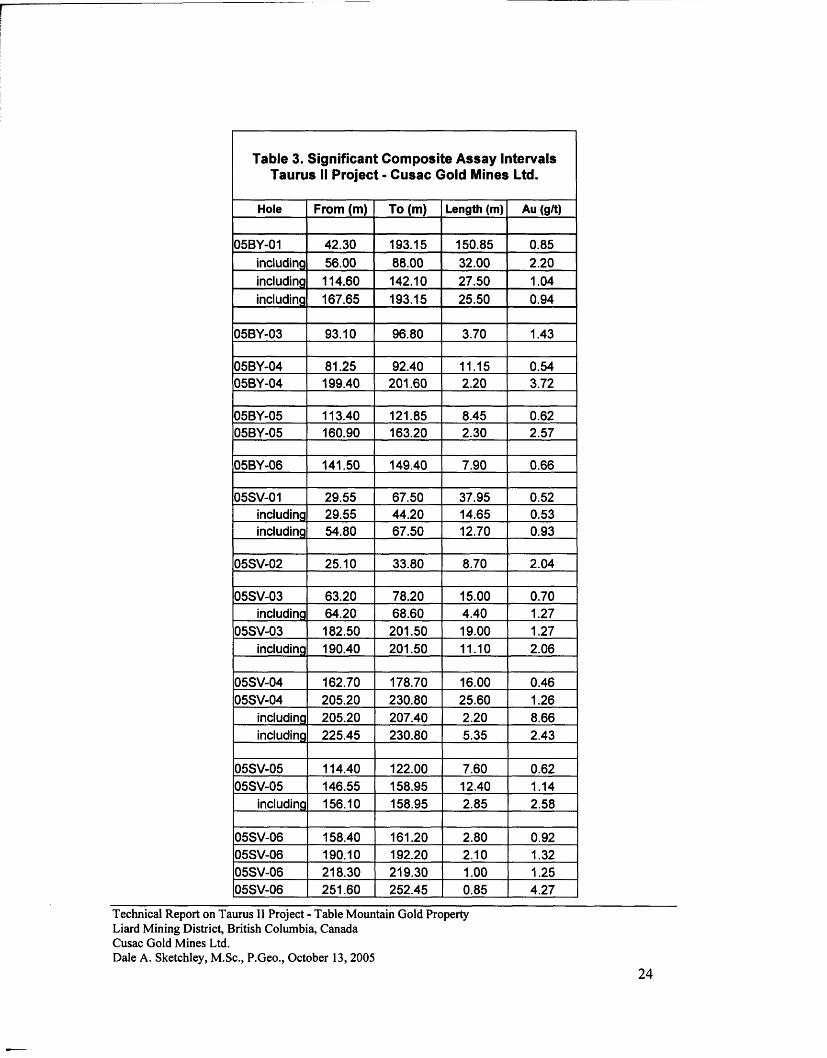
The Backyard System comprises several previously known, easterly striking and steeply south dipping, mineralized quartz vein and alteration zones on the east side of Troutline Creek, adjacent Highway 37, which were explored previously by trenching. Because surface access to the area was restricted due to infrastructure curtilage, the zone was drilled from the north to the south, which is not optimum for geological investigations; therefore, core sample lengths are greater than true widths. Drill hole locations are shown in Figure 6; reported significant drill hole intersections in Table 3 and Figure 9; and holes summarized herein.
1. 05BY-01 was targeted at the down dip portion of the surface exposures and returned highly elevated gold values from wide sulphide-rich alteration zones surrounding quartz veins.
2. 05BY-02 was targeted at surface soil colour anomalies north of the actual vein-alteration system, which were encountered during road construction for hole 05BY-01. No
Technical Report on Taurus II Project - Table Mountain Gold Property Liard Mining District, British Columbia, Canada Cusac Gold Mines Ltd. Dale A. Sketchley, M.Sc, P.Geo., October 13,2005
21
significant results were obtained because the anomalies are related to south-dipping ankeritic carbonate alteration zones that would not project into the drill hole trace.
3. 05BY-03 was targeted at the eastern extension of the system below a trenched surface exposure with elevated gold values. One narrower zone was intersected suggesting that the zone may be pinching.
4. 05BY-04 was targeted at the western extension of the system where it is exposed on the east side of Troutline Creek. Two widely spaced zones were intersected suggesting the system continues.
5. 05BY-05 and 05BY-06 were targeted at a western extension of the system on the western side of Troutline Creek. Two zones were intersected in "05" indicating that the system continues. A narrow zone intersected in "06" may be another zone.
The Backyard System is about 500 m long and appears lozenge shape, with the widest portion about 200 m east of Troutline Creek, and pinches further to the east and west, although it may join up with the Newcoast and Newcoast West areas. The widest portion coincides with the northerly projection of Troutline Creek before it enters McDame Lake, which could be related to a northerly controlling structure or else coincidence due to a modified creek channel in valley glacial deposits. Potential exists in the widest portion of the zone and to the west into the ECFZ adjacent to the argillite cap
Somerville System
The Somerville System comprises several previously known, easterly striking and steeply south dipping, mineralized quartz vein and alteration zones that were explored previously by trenching on the eastern side of Troutline Creek, north of the Backyard System. The zone has been interpreted to continue across Troutline Creek to the west. Surface access to both sides of the creek is good; hence, the zones were drilled from south to north to intersect south-dipping vein-alteration systems, although considering the steeply dipping nature of the zones, core sample lengths are greater than true widths. Drill hole locations are shown in Figure 7; reported significant drill hole intersections in Table 3 and Figure 9; and holes summarized herein.
1. 05SV-01 was targeted at the down-dip portion of the eastern extension of surface exposures and returned elevated gold values from wide sulphide-rich alteration zones surrounding quartz veins.
2. 05SV-02 was targeted at the down-dip portion of the western extension of surface exposures and returned elevated gold values from a sulphide-rich alteration zone surrounding quartz veins, which appears to be a continuation of the zone intersected in "01".
3. 05SV-03, 05SV-04, and 05SV-06 were targeted at the western extension of the system across Troutline Creek. Several widely spaced zones were intersected, indicating that the system continues to the west.
4. 05SV-05 was targeted at the western extension of the system at Troutline Creek, but was actually drilled south of the other drill holes. Two widely spaced zones were intersected, which may be new zones.
Technical Report on Taurus II Project - Table Mountain Gold Property Liard Mining District, British Columbia, Canada Cusac Gold Mines Ltd. Dale A. Sketchley, M.Sc, P.Geo., October 13,2005
22
The Somerville System is about 500 m long and open at both ends. The possibility of an eastern extension of the system, related to a northerly-trending structure that might control the Backyard System, should be investigated. Potential exists to the west into the ECFZ adjacent to the argillite cap
Porcupine East System
The Porcupine East System comprises several previously known, easterly striking, mineralized quartz veins previously explored by drilling The veins are east of McDame Lake on the south side of McDame Creek next to the west side of Mystery Lake and appear to be the eastern extension of surface exposures known as the Davis Porcupine area. Drill hole locations are shown in Figure 8. The zone appears to have limited potential.
1. 05PE-01 was drilled to look for extensions to a vein swarm intersected in hole 83M-21. Only one narrow higher grade zone was intersected.
11.0 SAMPLING METHOD AND APPROACH
Drill core sampling completed during the 2005 exploration program consisted of logging core, marking the mineralized sections into sample intervals based on geological criteria, splitting the core in half along its length using a continuous line to prevent bias, splitting with a manual hammer blade splitter, and bagging one-half of the split core from each marked sample interval. Average sample length is 0.9 m and average weight is 2.3 kg. A total of 595 samples was collected and sent for Routine Sample Assays (RSA). Screen Metallics Assays (SMA) were conducted on an additional 64 samples.
Core sample locations and sample results were verified in the field by the author. Sample results were compared with observed mineralogy including sulphides and visible gold (VG). In many cases, higher gold grades were returned where VG was noted in quartz veins, but in some cases VG was not noted; therefore, the weight of the coarse fraction and the grades of both the coarse and fine fractions were checked if available. Samples with visible gold generally have elevated gold grades in both fractions; however, samples with higher grades where VG was not observed generally returned higher gold grades in the fine fraction only and not in the coarse fraction, which would explain why visible gold was not observed.
Technical Report on Taurus II Project - Table Mountain Gold Property Liard Mining District, British Columbia, Canada Cusac Gold Mines Ltd. Dale A. Sketchley, M.Sc, P.Geo., October 13,2005
Technical Report on Taurus II Project - Table Mountain Gold Property Liard Mining District, British Columbia, Canada Cusac Gold Mines Ltd. Dale A. Sketchley, M.Sc, P.Geo., October 13, 2005
24
Figure 9. Taurus II Project - Significant Composite Assay Intervals.
Technical Report on Taurus II Project - Table Mountain Gold Property Liard Mining District British Columbia, Canada Cusac Gold Mines Ltd. Dale A. Sketchley, M.Sc, P.Geo., October 13, 2005
25
12.0 SAMPLE PREPARATION, ANALYSES, AND SECURITY
Samples were shipped on an as required basis with the following Chain of Custody:
1. Samples were put into individual plastic bags; 2. CRMs were inserted after every ninth routine sample for a total of 66 CRM's and three
field blanks used; 3. Several samples were put into a larger plastic bag and security tags attached; 4. Bags were packed in cardboard boxes wrapped in plastic packing tape; 5. Boxes were delivered to the Northern Thunderbird Air terminal in Dease Lake, B.C. for
air freight shipment to Smithers, B.C. where they were transferred to an Air Canada Jazz flight to Vancouver, B.C.;
6. Boxes were delivered by courier to Acme Analytical Laboratories Ltd.; 7. Sample Requisitions were faxed to Acme; and 8. The laboratory verbally acknowledged that tamper-proof seals were intact and all
samples accounted for.
Acme prepared samples for analysis, conducted RSA on all samples, and issued approved analytical certificates, which comprised electronic files and hard copy certificates stored at site. Samples are stored at the Acme facility in Vancouver, B.C.
Routine Sample Assays
Drill core samples are jaw crushed to 70% passing 10 mesh (2mm), a 250 gram riffle split is pulverized to 95% passing 150 mesh (100 ^m) in a mild-steel ring-and-puck mill. One assay ton aliquots (29.2 g) are weighed into fire assay crucibles, flux including PbO litharge and a Ag inquart are added, the sample-flux mixture is fused at 1,050° C to obtain a lead button, which is place on a cupel and fired at 950° C to produce a Au-Ag bead. The bead is weighed and leached in 1 ml of hot HNO3 acid to dissolve Ag, which is then dissolved with an additional 10 ml of HCL. The resultant solution is analyzed on a Jarrel-Ash Atomcomp model 975 ICP emission spectrometer.
Screen Metallics Assays
A 500 g reject split from the jaw crushed sample is pulverized to 95% passing 150 mesh (100 um), screened at 150 mesh to obtain coarse and fine fractions, the coarse fraction is assayed in total with an aliquot of the fine fraction assayed, and a weighted average calculation done to obtain a final gold value.
Technical Report on Taurus II Project - Table Mountain Gold Property Liard Mining District, British Columbia, Canada Cusac Gold Mines Ltd. Dale A. Sketchley, M.Sc, P.Geo., October 13,2005
26
13.0 DATA VERIFICATION AND VALIDATION
13.1 Data Transcription
Survey data was manually entered and assay data electronically transferred into a master spreadsheet and a Gemcom Access database. The spreadsheet is backed up every day and the Access database at least once per week. The author verified the analytical data with respect to the original electronic certificates as complete hard copy records had not been obtained at the time of the site visit. Field sample locations were checked through inspection of core archives.
13.2 Assay QA-QC
Program Outline
Assay results were obtained by Cusac in electronic format from Acme via email. Upon receipt of assay results, data was imported into the master spreadsheet and Gemcom database, with values for CRM's and FB's tabulated, plotted on QC control charts, and compared to pass-fail tolerance criteria based on a Round Robin program conducted by the supplier, CDN Mineral Resource Laboratories Ltd. of Delta, B.C. Nine CRM's were used with ID, means, and tolerance limits tabulated in Table 3. Failure criteria were set at actual SRM values outside of 3SD and two consecutive SRM values on the same side of the mean between 2 to 3 SD.
Standards Performance
Nine out of 66 CRMs failed the tolerance criteria; three batches were re-assayed; five did not contain significant values to warrant re-assaying; and one remains to be re-assayed. All CRM values for RSA are given in Tables 4a,b,c, and are illustrated in Figure 10.
Blank Sample Performance
Blank samples were limited in use throughout the drilling program and returned low values indicating no incidents of switching or contamination during sample preparation.
Screen Metallics Performance
Comparison of 64 SMA with RSA is illustrated in Figures 1 la,b. Scatter plots indicate that data precision decreases above 2 g/t and becomes quite poor above 6 g/t. A program is currently in progress to complete additional SMA above 2 g/t. RSA are replaced by SMA in the final database because the method eliminates the nugget effect.
Repeats Performance
Comparison of 23 laboratory repeat pulp sample assays is illustrated in Figures 12a,b,c. Scatter plots indicate that data precision decreases above 2 g/t, which is the same as observed for SMA.
Technical Report on Taurus II Project - Table Mountain Gold Property Liard Mining District, British Columbia, Canada Cusac Gold Mines Ltd. Dale A. Sketchley, M.Sc, P.Geo., October 13,2005
Table 4c. Quality Control Data Cusac Gold Mines Ltd. - Taurus II Project
SRM Sample Aug/t -3SD -2SD Mean +2SD +3SD Status Notes
GS-20 44310 21.09 19.595 19.93 20.6 X 21.27 21.605 p GS-20 44340 20.81 19.595 19.93 20.6 X 21.27 21.605 p GS-20 44380 20.04 19.595 19.93 X 20.6 21.27 21.605 p GS-20 44420 19.86 19.595 X 19.93 20.6 21.27 21.605 p GS-20 44430 20.42 19.595 19.93 X 20.6 21.27 21.605 p GS-20 44460 20.45 19.595 19.93 X 20.6 21.27 21.605 p GS-20 44470 20.29 19.595 19.93 X 20.6 21.27 21.605 p GS-20 44490 18.30 X 19.595 19.93 20.6 21.27 21.605 F Not significant GS-20 45110 19.67 19.595 X 19.93 20.6 21.27 21.605 P GS-20 45140 20.97 19.595 19.93 20.6 X 21.27 21.605 P GS-20 45180 20.52 19.595 19.93 X 20.6 21.27 21.605 P GS-20 45240 19.52 X 19.595 19.93 20.6 21.27 21.605 F Not significant GS-20 45270 20.66 19.595 19.93 20.6 X 21.27 21.605 P GS-20 45300 19.96 19.595 19.93 X 20.6 21.27 21.605 P GS-20 79180 17.82 X 19.595 19.93 20.6 21.27 21.605 F Not significant GS-20 79190 19.21 X 19.595 19.93 20.6 21.27 21.605 F Re-assayed GS-5 GS-20 79310 20.75 19.595 19.93 20.6 X 21.27 21.605 P GS-20 79330 20.65 19.595 19.93 20.6 X 21.27 21.605 P GS-20 79380 20.03 19.595 19.93 X 20.6 21.27 21.605 P GS-20 79410 19.37 X 19.595 19.93 20.6 21.27 21.605 F Re-assay
Technical Report on Taurus II Project - Table Mountain Gold Property Liard Mining District, British Columbia, Canada Cusac Gold Mines Ltd. Dale A. Sketchley, M.Sc, P.Geo., October 13,2005
30
24 i
t
Table Mountain Gold Property - Cusac Gold Mines Ltd. Gold Values for CRM's Used with Routine Sample Assays
(See Tables 4a,b,c for Original and Re-Assayed Data)
Technical Report on Taurus II Project - Table Mountain Gold Property Liard Mining District, British Columbia, Canada Cusac Gold Mines Ltd. Dale A. Sketchley, M.Sc, P.Geo., October 13, 2005
33
14.0 ADJACENT PROPERTIES
No information on adjacent properties is included in this report other than historical information on the chronology of exploration and mining events and general geological descriptions.
15.0 MINERAL PROCESSING AND METALLURGICAL TESTING
Mineral processing and/or metallurgical testing analyses have not been carried out recently and do not form part of this report.
16.0 MINERAL RESOURCE ESTIMATES
There are no mineral resources defined in the project area on claims owned by Cusac. Mineral resources and reserves for underground mineable deposits that occur elsewhere on claims owned by Cusac in the Cassiar area have been described by Sketchley (1998, 2003, 2004) and Bergen (2005). Several historic, non NI43-101 compliant, mineral inventories were outlined for open pit mineable deposits in the Taurus Mine - Hill 88, approximately 4 km to the northwest of the Taurus II Project area. An initial mineral inventory outlined by Cypress Canada Inc. during 1995, which used only diamond drill holes, was reported at 38 million tonnes at 1.42 g/tonne. Cusac completed a re-estimation during 1999 using all available diamond and RC drill holes and reported a mineral inventory of 62 millions tonnes at 0.8 g/tonne (Bird 1999). Differences are related to calculation methods and cut-off grades, as well as drill holes used.
17.0 ADDITIONAL REQUIREMENTS FOR TECHNICAL REPORTS ON DEVELOPMENT PROPERTIES AND PRODUCTION PROPERTIES
Information regarding Mining Operations, Recoverability, Markets, Contracts, Environmental Considerations, Taxes, Capital and Operating Cost Estimates, Economic Analysis, Payback, and Mine Life are beyond the scope of this report. The reader is referred to Environmental Reports by Hunt (2003) for reclamation work, Griffin (2003) for tailings storage facilities, and Glover and Brett (2003) for mine closure plans.
18.0 INTERPRETATION AND CONCLUSIONS
18.1 Interpretation
Most significant gold mineralization in the Cassiar area occurs within a zone less than 1 km wide centred on a gold-bearing hydrothermal system developed along the northerly-trending Erickson Creek Fault Zone. The majority of individual high-grade veins that have been mined occur in basalt immediately under argillite caps proximal to flexures in structures that comprise the fault zone. In contrast, swarms of smaller gold-bearing veins within massive basalt, which have no Technical Report on Taurus II Project - Table Mountain Gold Property Liard Mining District, British Columbia, Canada Cusac Gold Mines Ltd. Dale A. Sketchley, M.Sc, P.Geo., October 13,2005
34
apparent relationship to overlying argillite caps, have not been mined. These vein swarms, which may be the root zones of veins occurring under argillite caps at higher stratigraphic-structural levels, appear to be significant when they occur proximal to an impermeable buttress that could have channelled fluids into fractured, massive basalt bounded by an overlying structure.
18.1 Conclusions
The author concludes that potential exists in the Taurus II project area to outline gold-bearing vein-alteration systems that could be amenable to open pit mining. Emphasis should be place on looking for litho-structural features that could have controlled hydrothermal fluid flow resulting in the coalescing of swarms of anastomosing gold-bearing vein-alteration zones to form areas worthy of additional exploration. The Dribble Creek area is a corridor of exploration interest, particularly where the Backyard, Somerville, North Notch, Newcoast and Newcoast West areas trend into the Erickson Creek Fault Zone and adjacent parallel structures.
19.0 RECOMMENDATIONS
19.1 Exploration Practises
The following practises are recommended to improve project work procedures.
1. Drill collar locations are currently marked with a small wooden plank and a small metal Dymo tag, which is acceptable; however, a longer lasting marking method with larger posts should be considered to discourage animals from chewing tags and humans from removing posts.
2. An additional Sperry Sun reading below hole collars would improve survey control currently based on aligning rigs by compass.
3. Calibration checks of the Sperry Sun should be done with hand compasses to ensure that instruments are functioning properly.
4. More emphasis should be placed on recording of mineralization and alteration features considering that a new style of mineralization is being explored for.
5. Geotechnical data such as RQD and fracture frequency should be collected for potential open pit mine planning.
6. Core should be re-assembled along a piece of upward-facing angle iron, marked with a horizontal cutting line, and cut with a core saw.
7. Mineralized zones should be sampled in their entirety including a reasonably sized zone of adjacent barren wall rock and any internal barren zones.
8. The beginning and end of samples should be marked on the side of core box rungs with embossed metallic tags.
9. Small wooden blocks marked with SD (Sample Delineator) should be placed between split core along core box rungs to ensure that core is segregated for accurate re-examination.
Technical Report on Taurus II Project - Table Mountain Gold Property Liard Mining District, British Columbia, Canada Cusac Gold Mines Ltd. Dale A. Sketchley, M.Sc, P.Geo., October 13, 2005
35
10. An analytical audit should be conducted on the assaying laboratory before commencement of a program of analytical work, i.e. 40 samples comprising eight of each of five SRMs that cover the grade range expected, which are currently available from the on-site inventory.
11. Information regarding chain of custody tamper-proof seals should be returned to field personnel from the laboratory by non-verbal methods to ensure a proper audit trail.
12. Samples should be submitted to a preparation facility in batches of 20 samples, which would include one field blank, one pulp duplicate, and one SRM, i.e. 17 routine samples and three QC samples, and then submitted in batches of similar looking and sized pulp samples to another laboratory for assaying. The reason for this is because the large number of higher grade analyses should be assayed with a blind QC program.
13. SRMs should be grade matched to average zone grades and not with higher grade standards in lower grade mineralization.
14. The assaying laboratory should be instructed to clean sample equipment after samples where visible gold has been noted to minimize cross contamination potential.
15. The practise of averaging repeat pulp duplicates provided by the assaying laboratory and then to include the averaged result into the final database should be discontinued. The process used by laboratories to select the repeat samples is frequently biased and averaging reduces the natural variability of a select group of samples. Repeat duplicates provided by a laboratory should be used for monitoring internal precision and re-submitted blind duplicates used for monitoring external precision as well laboratory biases. If the practise of averaging assays is to be followed then it should be done on complete data sets, so that all data are treated in a similar and consistent manner. If there are concerns about issues related to the nugget effect then screen metallics assays should be completed.
16. An independent check assay program should be initiated. 17. Screen metallics assays should be done on all samples above 2 g/t to eliminate the nugget
effect. 18. Although cross-sections have been generated for individual drill holes as required, a set
of regularly spaced cross-sections should be constructed to project mineralized zones between surface showings and drill intersections as well as along strike to facilitate further exploration.
19.2 Work Program
In order to explore for larger tonnage, near surface mineralization amenable to open pit mining in the Taurus II project area, a three phase exploration program with a budget of $1.53 million is recommended. The first phase comprises base line studies that are needed to develop targets; the second diamond drilling of high priority targets; and the third follow-up diamond drilling.
Technical Report on Taurus II Project - Table Mountain Gold Property Liard Mining District, British Columbia, Canada Cusac Gold Mines Ltd. Dale A. Sketchley, M.Sc, P.Geo., October 13, 2005
36
A description of the work program is as follows:
1. A GIS image base is required to ensure all information is compiled with appropriate geographic relationships.
2. Detailed historical geological mapping needs to be incorporated with GIS image base to provide a better understanding of the geological setting of the area.
3. Petrographic and gold occurrence studies are needed to understand gold relationships. 4. Soil sampling will update fragmented and spotty historical coverage to provide consistent
coverage for GIS integration. 5. Magnetic and VLF-EM testing will help to understand the usefulness of these tools
considering that the Bain Vein in the Cusac Mine area was discovered by following up a VLF-EM anomaly. Testing should be done over the Backyard and Newcoast areas.
6. Examination of outcrops and anomalies on the ground is needed to place all baseline information in context before investigation by drilling.
7. Surface land ownership in the area of the Backyard System should be obtained before further exploration is conducted.
8. Drilling should be done by diamond coring to understand geological relationships.
An estimated cost of individual items is described herein.
Phase 1 1. GIS imaging and aerial photo study $ 50,000 2. Compilation of remaining geological data $ 30,000 3. Petrographic and gold occurrence study $ 10,000 4. Soil sampling survey - 50 km @ 25 m spacing @ $20/sample $ 40,000 5. Magnetic and VLF-EM test study $ 10,000 6. Geological ground examination study $ 20,000 7. Support costs (food, lodging, 1st aid, vehicle, equipment) $ 75,000
Subtotal $ 235,000
Phase 2 1. Diamond drilling - 20 holes @ 200 m @ $ 160/m all up $ 640,000
Phase 3 1. Diamond drilling - 20 holes @ 200 m @ $ 160/m all up $ 640,000
(includes mob, demob, drilling, logging, assaying, camp costs) 2. Independent Qualified Person Site Visit, Review, and Report $ 15,000
Subtotal $ 655,000
AH Phases Total $ 1,530,000
Technical Report on Taurus II Project - Table Mountain Gold Property Liard Mining District, British Columbia, Canada Cusac Gold Mines Ltd. Dale A. Sketchley, M.Sc, P.Geo., October 13,2005
37
20.0 REFERENCES
Bain, J., Yip, G., Ball, M., (1991): Bain Vein Ore Reserve Calculation - Quadrilateral Method. Unpublished Company Report for Total Energold Corporation, unknown pages.
Ball, M., 1985. Structural Geology Associated with Gold-Bearing Quartz Veins in the McDame Gold Mining Camp, Liard Mining Division, Cassiar District, British Columbia: Unpublished Company Report for Erickson Gold Mining Corporation, 22 pages.
Ball, M. 1989. Erickson Gold: Geology and Model of Ore Formation; Unpublished Company Report for Total Energold Corporation, 75 pages.
Ball, M., (1994) :1994 Exploration Plan for the Table Mountain Gold Property. Unpublished Company Report for Cusac Industries Ltd., unknown pages.
Barlee, N.L., 1980. The Guide to Gold Panning in British Columbia; Canada West Publications, 192 pages.
Beaton, A.J., 2003. Cost Analysis of Development for East Bain Vein. Unpublished Company Report for Cusac Gold Mines Ltd., 3 pages.
Bergen, R.D., 2005. Rory and East Bain Veins, Table Mountain Gold Property, Liard Mining District, British Columbia. Unpublished Company Technical Report for Cusac Gold Mines Ltd., 88 pages.
Bird, W.H., 1999. Taurus Project, Liard Mining District, British Columbia. Unpublished Company Technical Report for Cusac Gold Mines Ltd., 41 pages.
Broughton, D., and Masson, M., 1996. Report on 1995 Exploration Program on the Taurus Project, B.C., NTS 104P/5; Unpublished Company Report for Cyprus Canada Inc., 57 pages and appendices.
Canadian Securities Administrators, 2001. National Instrument 43-101 Standards of Disclosure for Mineral Projects. Summary Brochure
Canadian Securities Administrators, 2001. National Instrument 43-101 Standards of Disclosure for Mineral Projects. Policy Document.
Canadian Securities Administrators, 2001. Companion Policy 43-101CP. Policy Document.
Canadian Securities Administrators, 2001. Technical Report Form 43-101F1. Policy Document.
CIM Standing Committee on Reserve Definition, 2000. CIM Standards on Mineral Resources and Reserves - Definitions and Guidelines.
Technical Report on Taurus II Project - Table Mountain Gold Property Liard Mining District, British Columbia, Canada Cusac Gold Mines Ltd. Dale A. Sketchley, M.Sc, P.Geo., October 13, 2005
38
Diakow, L.J. and Panteleyev, A., 1981. Cassiar Gold Deposits, McDame Map-area (104P/4,5); in Geological Fieldwork 1980, British Columbia Ministry of Energy, Mines and Petroleum Resources, Paper 1981-1, pp 55-62.
Downie, I., 1997. A Review of the Table Mountain Gold Property and Recommendations for Exploration; Unpublished Company Report for Cusac Gold Mines Ltd., Iain Downie Geoconsult, 20 pages and appendices.
Dussel, E., 1986. Listwanites and their Relationship to Gold Mineralization at Erickson Mine, British Columbia, Canada; Unpublished M.Sc. thesis, Western Washington University, 90 pages.
Ey, F., 1986. Structural Analysis of the Cusac Decline, Erickson Gold Mine, Cassiar, B.C.; Unpublished Company Report for Erickson Gold Mining Corporation, Minatco Ltd., 11 pages and appendices.
Ey, F., 1987. Structural Control of the Vollaug Gold Bearing Quartz Vein, Total Erickson, Erickson Gold Mine, Cassiar, B.C.; Unpublished Company Report for Erickson Gold Mining Corporation, Minatco Ltd., 9 pages and appendices.
Fitzpatrick, K.P., and Glover, M.J., 2003. Table Mountain Gold Property, East Bain Vein Mining Plan, Nu-Tara and Cordoba Mining Claims, Liard Mining Division. Unpublished Company Report for Cusac Gold Mines Ltd., 42 pages.
Fjetland, G. 1982. A Microscopy Investigation of the Gold and Sulphides from the Erickson Mine, Cassiar, B.C.; Unpublished Company Report for Erickson Gold Mining Corporation.
Gabrielse, H., 1963. McDame Map-Area, Cassiar District, British Columbia; Geological Survey of Canada, Memoir 319, 138 pages.
Gordey, S.P., Gabrielse, H. and Orchard, M.J., 1982. Stratigraphy and Structure of the Sylvester Allochthon, Southwest McDame Map Area, Northern British Columbia; in Current Research, Part B, Geological Survey of Canada, Paper 82-IB, pp 101-106.
Glover, M., 1998. Table Mountain Gold Property, 1998. Project Review and Exploration Proposal. Unpublished Company Report for Cusac Gold Mines Ltd., 33 pages.
Glover, M.J., 2002a. Table Mountain Gold Property, Diamond Drilling Report, East Bain Vein, 2002 Field Season. Unpublished Company Report for Cusac Gold Mines Ltd., 29 pages and appendices.
Glover, M.J., 2002b. United States Securities & Exchange Commission, Form 20-F. Annual Report Pursuant to Section 13 or 15 (d) of the Securities Exchange Act of 1934 for the Fiscal year Ended December 31, 2002, Commission File Number 0-13548, Cusac Gold Mines Ltd.
Technical Report on Taurus II Project - Table Mountain Gold Property Liard Mining District, British Columbia, Canada Cusac Gold Mines Ltd. Dale A. Sketchley, M.Sc, P.Geo., October 13,2005
39
Glover, M.J., 2003. Table Mountain Gold Property, East Bain Vein Mining Project Summary, Nu-Tara and Cordoba Claims. Unpublished Company Report for Cusac Gold Mines Ltd., pages and appendices.
Glover, M.J., 2004. Table Mountain Gold Property, Diamond Drilling Report, Don and High Claims, 2003 Field Season. Unpublished Company Report for Cusac Gold Mines Ltd., 33 pages and appendices.
Glover, M.J., and Brett, D., 2003. Table Mountain Gold Property, Mine Closure Plan, Reclamation Permit M-127, Liard Mining Division. Unpublished Company Report for Cusac Gold Mines Ltd., 38 pages and appendices.
Grant, D.R., 1981. A Study of the Sulphide Mineralogy and Geology of the McDame Gold Camp, Cassiar, British Columbia, Unpublished B.A.Sc. thesis, The University of British Columbia, 78 pages.
Gunning, M.H., 1988. Cornucopia (Taurus Mine), Gold Distribution in the Taurus Mine Quartz Veins; British Columbia Ministry of Energy, Mines and Petroleum Resources, Exploration in British Columbia 1987, pp B95-B105.
Harms, T.A., 1986. Structural and Tectonic Analysis of the Sylvester Allochthon, Northern British Columbia: Implications for Paleogeography and Accretion, Unpublished Ph.D. Thesis, The University of Arizona.
Harms, T., 1989. Geology of the Northeast Needlepoint Mountain and Erickson Mine Areas, Northern British Columbia; in Geological Fieldwork 1989, British Columbia Ministry of Energy, Mines and Petroleum Resources, Paper 1990-1, pp 339-345.
Harms, T., Ball, M., Fischer, P. and Nelson, J. 1989. Geology of the Needlepoint Mountain Map Area; British Columbia Ministry of Energy, Mines and Petroleum Resources, Open File 1989-19, 1:25,000 map.
Holland, S.S., 1950. Placer Gold Production of British Columbia, British Columbia Ministry of Energy, Mines and Petroleum Resources, Bulletin 28 (reprinted in 1980), 89 pages.
Hooper, D., 1984. A Study of the Gold-quartz Veins at Erickson Gold Camp, Cassiar, North-Central British Columbia; Unpublished B.Sc. thesis, The University of British Columbia, 96 pages.
Hunt, L.C., 2003. Reclamation Report for 1998 - 2002 on the Table Mountain Gold Property. Unpublished Company Report for Cusac Gold Mines Ltd., 21 pages.
Technical Report on Taurus II Project - Table Mountain Gold Property Liard Mining District, British Columbia, Canada Cusac Gold Mines Ltd. Dale A. Sketchley, M.Sc, P.Geo., October 13,2005
40
Mandy, J.T., 1935. McDame Creek Area, Dease River; British Columbia Minister of Mines Annual Report, 1935, pp. B12-B22.
Mandy, J.T., 1937. McDame Creek Area; British Columbia Minister of Mines Annual Report, 1937,pp.B24-B37.
Nelson, J.L, 1990. Evidence for a Cryptic Intrusion Beneath the Erickson-Taurus Gold-Quartz Vein system, Near Cassiar, B.C. (104P/4,5); in Geological Fieldwork 1989, British Columbia Ministry of Energy, Mines and Petroleum Resources, Paper 1990-1, pp 229-233.
Nelson, J.L. and Bradford, J.A., 1989. Geology and Mineral Deposits of the Cassiar and McDame Map Areas, British Columbia (NTS 104P/3,5) in Geological Fieldwork 1988, British Columbia Ministry of Energy, Mines and Petroleum Resources, Paper 1989-1, pp 323-328.
Nelson, J.L. and Bradford, J.A., 1993. Geology of the Midway-Cassiar Area, Northern British Columbia (104O, 104P) Ministry of Energy, Mines and Petroleum Resources, Bulletin 83, 94 pages.
Panteleyev, A, and Diakow, L.J., 1982. Cassiar Gold Deposits, McDame Map-area; in Geological Fieldwork 1981, British Columbia Ministry of Energy, Mines and Petroleum Resources, Paper 1982-1, pp 156-161.
Panteleyev, A., Broughton, D., and Lefebure, D., 1997. The Taurus Project, A Bulk Tonnage Gold Prospect near Cassiar, British Columbia, NTS 104P/5; in Geological Fieldwork 1996, British Columbia Ministry of Employment and Investment, Energy and Minerals Division, Geological Survey Branch, Paper 1997-1
Read, P.B. and Psutka, J.F., 1983. Surface Geology, Taurus Mine, Cassiar B.C.; Unpublished Company Report for Trenaman, Spencer and Associates Limited, Geotex Consultants Limited, 31 pages and appendices.
Sketchley, D.A., 1986. The Nature of Carbonate Alteration in Basalt at Erickson Gold Mine, Cassiar, North-central British Columbia; unpublished M.Sc. thesis, The University of British Columbia, 272 pages.
Sketchley, D.A., Sinclair, A.J., and Godwin, C.I., 1986. Early Cretaceous Gold-Silver Mineralization in the Sylvester Allochthon, near Cassiar, North Central British Columbia; Canadian Journal of Earth Sciences, Vol. 23, No. 9, pp 1455-1458.
Sketchley, D.A. and Sinclair, A.J., 1989. Carbonate Alteration in Basalt at Total Erickson Gold Mine, Cassiar, Northern British Columbia; Economic Geology, Vol. 86, No. 3, pp. 570-587.
Sketchley, D.A., 1998. Geological Evaluation of the Cassiar Gold Camp, British Columbia. Unpublished Company Technical Report for Cusac Gold Mines Ltd., 34 pages.
Technical Report on Taurus II Project - Table Mountain Gold Property Liard Mining District, British Columbia, Canada Cusac Gold Mines Ltd. Dale A. Sketchley, M.Sc, P.Geo., October 13, 2005
41
Sketchley, D.A., 2001. Geological Evaluation of the Cassiar Gold Camp, British Columbia. Unpublished Company Summary Technical Report for Cusac Gold Mines Ltd., 10 pages.
Sketchley, D.A., 2003. Table Mountain Gold Property, Liard Mining District, British Columbia. Unpublished Company Technical Report for Cusac Gold Mines Ltd., 125 pages including appendices.
Sketchley, D.A., 2004. Rory Vein, Table Mountain Gold Property, Liard Mining District, British Columbia. Unpublished Company Technical Report for Cusac Gold Mines Ltd., 41 pages.
Trenaman, R.T., 1997. Report on the 1996 Exploration Program - Taurus Project, Cassiar, British Columbia; Unpublished Company Report for International Taurus Resources Inc., 31 pages and appendices.
Westervelt, R. D.,(1993). A Summary Review Report on the Table Mountain Gold Property, Cassiar, British Columbia. Unpublished Company Report for Cusac Industries Ltd., 31 pages and appendices.
Wilde, C.J., 2003. Report on Exploration Activities on the Taurus Property, Liard Mining Division; Unpublished Company Report for Navasota Resources Limited, 26 pages plus appendices.
Technical Report on Taurus II Project - Table Mountain Gold Property Liard Mining District, British Columbia, Canada Cusac Gold Mines Ltd. Dale A. Sketchley, M.Sc, P.Geo., October 13, 2005
42
21.0 DATE AND SIGNATURE PAGE
I, Dale A. Sketchley, certify the following:
1. I am an independent consulting geologist, employed by Acuity Management Ltd., with office at 15068 Spenser Court, Surrey, B.C., Canada V3S 5Z8.
2. I earned a Bachelor of Science in Geology-Geophysics in 1975 and a Master of Science in Geology in 1986, at The University of British Columbia.
3. I am a Professional Geoscientist registered with The Association of Professional Engineers and Geoscientists of the Province of British Columbia, No. 23913.
4. I am registered as a Fellow of the Geological Association of Canada and a member of the Canadian Institute of Mining, Metallurgy and Petroleum.
5. I have practised my profession for 30 years and I am experienced in open pit and underground feasibility and development studies, resource/reserve estimation, ore reserve reconciliation audits, mine site and regional exploration, which includes extensive work in sampling, QA-QC, and data analysis.
6. I am a Qualified Person, as outlined in National Instrument 43-101 of the Canadian Securities Administrators, and I have read National Instrument 43-101 and its companion policies.
7. The Technical Report dated October 13h, 2005, and titled "Taurus II Project - Table Mountain Gold Property", was prepared for Cusac Gold Mines Ltd. and is based on an evaluation of data conducted by me. The quality of information and conclusions contained in it are consistent with the level of work involved in my services and based upon: i) information available at the time of preparation, ii) data supplied by outside sources, and iii) the assumptions, conditions, and qualifications set forth within it. I am not aware of any material fact or item that could change or affect the conclusions contained in this memorandum.
8. My most recent visit to the property took place from September 21 to 23,2005. 9. Other than my capacity as an independent consulting geologist to Cusac Gold Mines Ltd., I
have not received and do not expect to receive a direct or indirect interest in the properties described in this report, nor in Cusac Gold Mines Ltd.
10. Permission is given to Cusac Gold Mines Ltd. to use this report in its complete form. Permission must be obtained before publication of any portion of this report.
Dated the 13h day of October, 2005 and submitted in electronic format only.
Dale A. Sketchley, M.Sc, P.Geo. (Signed)
Technical Report on Taurus II Project - Table Mountain Gold Property Liard Mining District, British Columbia, Canada Cusac Gold Mines Ltd. Dale A. Sketchley, M.Sc, P.Geo., October 13,2005
43
Technical Report on Taurus II Project - Table Mountain Gold Property Liard Mining District, British Columbia, Canada Cusac Gold Mines Ltd. Dale A. Sketchley, M.Sc, P.Geo., October 13, 2005
44
Schroeter, Tom EMPR:EX
From: Schroeter, Tom EMPR:EX Sent: Wednesday, November 02, 2005 11:22 AM To: 'George Sanders'; XT:EM Garratt, Glen L EM:IN Subject: RE: Dale Sketchley Taurus II October '05 Report Attached
Thanks, George - got it. With reference to pg. 37, can I assume that Phase 1 was completed as indicated; Phase 2 only had 13 holes totalling 2444m? Phase 3 which you're just completing - how many holes (meterage)? Total cost for 2005 project =? Nice looking report. Would sure like to see some cross sections from the drilling. Good luck with your discussions with the American Bonanza Gold Corp. folks.
Tom Tom Schroeter, P.Eng./P.Geo. Senior Regional Geologist Geological Survey Branch Mining and Minerals Division Ministry of Energy, Mines and Petroleum Resources
Original Message From: George Sanders [mailto:[email protected]] Sent: Wednesday, November 02, 2005 10:36 AM To: XT:EM Garratt, Glen L EM:IN; Schroeter, Tom EMPR:EX Subject: Dale Sketchley Taurus II October '05 Report Attached
2005-11-02
Dear Glenn and Tom:
This is the latest report on Cusac's drilling program in the Cassiar. It has been released on SEDAR.