landscape and urban design masterplan | 1 SH1 Te Rapa Bypass NZTA 2/03-016/601 | our road, our city, our future | engineering excellence in harmony with our surroundings l l lan and ds dsca cape pe a a d nd nd u u b rb rban an d d des esi ig ign n ma ma t st ster er l pl plan an | 1 SH1 Te Rapa Bypass NZTA 2/03-016/601 | our road, our city, our future | engineering excellence in harmony with our surroundings Landscape and Urban Design Masterplan VISION Te Rapa Bypass – the Waikato Link – the Hamilton Greenway GOALS • create a linear green entrance parkway to the north of Hamilton • be an integral part of the surrounding area • provide structure and opportunities for future land use change • provide a core green space which can spread out/within the wider community • improve connectivity and create an identity and ownership for the future direction of the city • complement the Waikato River landscape and local culture and enhance local biodiversity
Transcript
landscape and urban design masterplan | 1SH1 Te Rapa Bypass NZTA 2/03-016/601 | our road, our city, our future | engineering excellence in harmony with our surroundings ll l lanandddsdscacapepe a a ddndnd u u bbrbrbanan dd d desesiiigign n mama ttststerer llplplanan | 1SH1 Te Rapa Bypass NZTA 2/03-016/601 | our road, our city, our future | engineering excellence in harmony with our surroundings
Landscape and Urban Design Masterplan
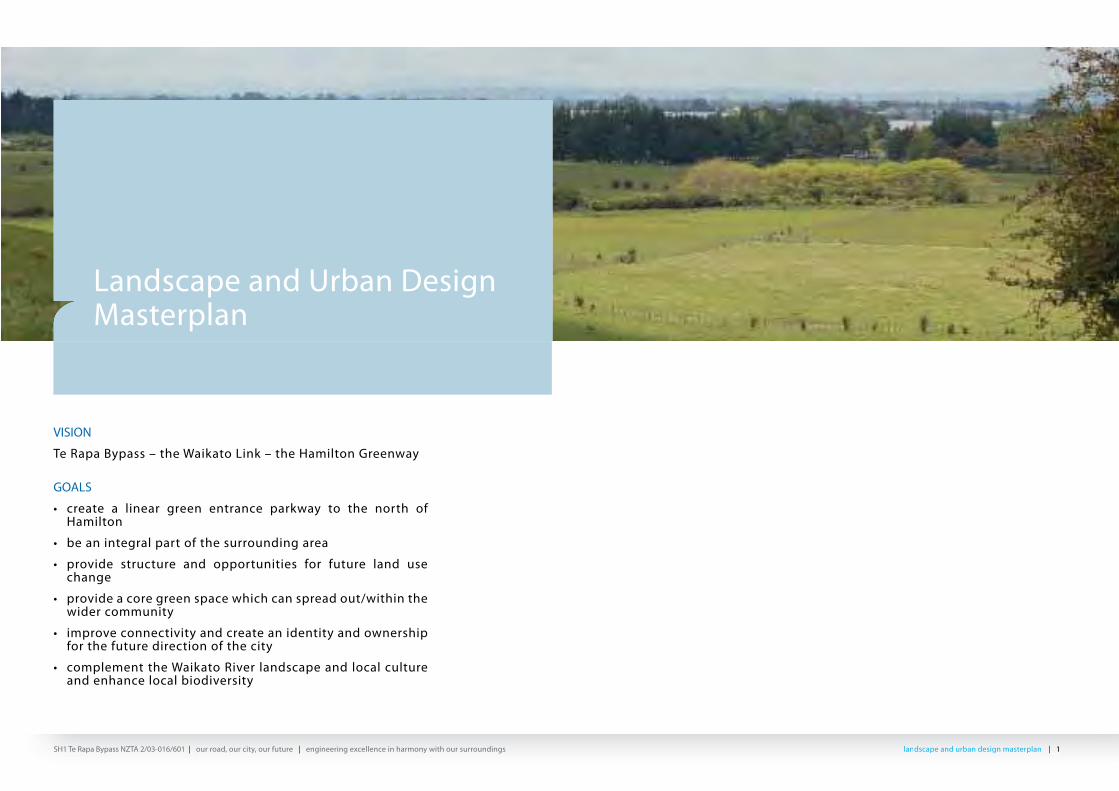
VISION
Te Rapa Bypass – the Waikato Link – the Hamilton Greenway
GOALS
• create a linear green entrance parkway to the north of Hamilton
• be an integral part of the surrounding area
• provide structure and opportunities for future land use change
• provide a core green space which can spread out/within the wider community
• improve connectivity and create an identity and ownership for the future direction of the city
• complement the Waikato River landscape and local culture and enhance local biodiversity
landscape and urban design masterplan | 2SH1 Te Rapa Bypass NZTA 2/03-016/601 | our road, our city, our future | engineering excellence in harmony with our surroundings lllala ddndndscscapape e ananddd d ururbbbaban n dddede iisisigngn m masasttteterprplllalann | 2SH1 Te Rapa Bypass NZTA 2/03-016/601 | our road, our city, our future | engineering excellence in harmony with our surroundings
CONTENTS
1 The Vision 1.1 Hamilton Green Way 2 Design Intent2.1 Landscape and Urban Design2.2 Landscape and Urban Design Goals 3 Project Context 3.1 Background 3.2 Principals Requirements - Key Design Objectives and Outcomes 3.3 State Highway Designation NOR3.4 Regional Context 3.5 Local Landscape Context 3.6 Cultural and Heritage Context 3.7 Urban Context 4 Landscape and Urban Design Concept 4.1 Urban Design Principles 4.2 Connections/Open Space Strategy4.3 Design Character 4.4 Integrated Design Approach
4.5 Ecology, Biodiversity and Sustainability 4.6 Integrated Storm Water Design Solutions 4.7 Innovative Solutions 4.8 Local Stakeholders 4.9 Cost Effective Design Benefits 5 Design Elements5.1 Materials Palette 5.2 Planting 5.3 Planting Types5.4 Structures 5.5 Pedestrian & cycleway5.6 Site Furniture 6 Concept Plans 6.1 Cross Sections7 Arts Integration in the Designs 8 Planting Management and Maintenance 8.1 Planting Management and Maintenance 9 Appendices 9.1 Planting Schedule 9.2 Planting Matrix 10 Bibliography
WAIKATO LINK LANDSCAPE AND URBAN DESIGN TEAM
Helen Preston Jones – Principal Project Landscape Architect/Urban DesignerAdrian Morton – Principal Landscape Architect/Urban DesignerJoanna Soanes – Senior Landscape ArchitectDavid McKenzie - Principal Landscape ArchitectSharyn Ogg - Senior Landscape ArchitectStefan Geelen – Structures ArchitectPaul Smith – Structures ArchitectWarren Bird – Stormwater EngineerJohn Turner – EcologistKevin Brewer - Urban Designer
landscape and urban design masterplan | 3SH1 Te Rapa Bypass NZTA 2/03-016/601 | our road, our city, our future | engineering excellence in harmony with our surroundings lllala ddndndscscapape e ananddd d ururbbbaban n dddede iisisigngn m masasttteterprplllalann | 3SH1 Te Rapa Bypass NZTA 2/03-016/601 | our road, our city, our future | engineering excellence in harmony with our surroundings
1. THE VISION
1.1 Te Rapa Bypass – the Waikato Link – the Hamilton Greenway The design vision for the Bypass is to achieve a linear green entrance to Hamilton City, creating a new approach from the north, which will supercede the current State Highway. Its purpose is to facilitate north/south through traffic, while providing for growth and local connectivity within the area. Although its primary function is as a bypass to Te Rapa, provides the opportunity to make a significant contribution to the future of Hamilton City.
The vision reflects the changing land use and surroundings for the northern part of Hamilton City and encapsulates the local Waikato River character, while providing a framework which will respond to the urbanization of the area over time as the city’s boundary changes.
The changing land uses suggest a linear entrance to the city rather than a particular “gateway
location”. The design framework provides connections along and across its length, defining nodal points of transfer between the developing local areas, and the Bypass route. The northern approach to the city will have a unique character utilising an approach which is bold, with strong forms while adding a degree of ‘softness’ as the road passes through rural, residential and industrial areas.
The design provides a strong form which is compatible with both the scale of the landscape, and the scale and form of the future development proposed along its margins. The design approach will complement both the current open landscape character and the future built form of the area. Development of this vision has been a product of the whole team, both design and contracting disciplines. Design skills have been drawn from landscape architecture, urban design, architects, ecology, civil and bridge engineering, planning and acoustics, heritage and cultural experts.
2. DESIGN INTENT
2.1 Landscape and Urban Design The landscape and urban design master plan encompasses the vision with the aim to create a highway system which is integrated with its surroundings, reflecting the past and present, and allows for changing land uses over time. The design elements add yet another layer to the landscape, reflecting the underlying landform, natural elements, patterns and processes. In the long term the design will develop and mature to provide a highway landscape framework appropriate for the change and development of the adjacent land.
The design has taken account of the key objectives and outcomes required by the New Zealand Transport Association (NZTA). These requirements include integrating environmental, landscape and urban design elements into the overall design and construction process. To achieve this, the following landscape and urban design goals have been set:
2.2 Landscape and Urban Design Goals
To demonstrate the connection and character, the landscape and urban design goals set for the Te Rapa Bypass are to:• create a linear green entrance parkway to the
north of Hamilton
• be an integral part of the surrounding area
• provide structure and opportunities for future land use change
• provide a core green space which can spread out/within the wider community
• improve connectivity and create an identity and ownership for the future direction of the city
• complement the Waikato River landscape and local culture and enhance local biodiversity.
landscape and urban design masterplan | 4SH1 Te Rapa Bypass NZTA 2/03-016/601 | our road, our city, our future | engineering excellence in harmony with our surroundings ll l lanandddsdscacapepe a a ddndnd u u bbrbrbanan dd d desesiiigign n mama ttststerer llplplanan | 4SH1 Te Rapa Bypass NZTA 2/03-016/601 | our road, our city, our future | engineering excellence in harmony with our surroundings
3 PROJECT CONTEXT
3.1 BackgroundThe project is located parallel to the existing State Highway 1 (SH1), the great northern route between Hamilton to Auckland. The bypass will improve the connection between the cities and also act as a catalyst to the growth and development of Hamilton beyond the northern fringe of the current City boundary. It will facilitate progress on the approved HCC Rotokauri Structure Plan and the preliminary WDC Horotiu Structure Plan, which are to guide future development of the area. As such, much of the urban land use and transportation elements which underlie urban design outcomes have already been considered in
the proposal for which the Notice of Requirement (NOR) was granted
The NOR requirement and the specimen design was developed in conjunction with the two local authorities, to provide for their future growth. Key factors to meet the needs of the community are the location of local roads, bridges and underpasses, public transport routes, cycle and pedestrian ways, and the drainage systems. These, together with the amendments included in the current design requirements, have been worked through to provide a roading system of functionality and attractiveness for both through travellers and local road users.
The project runs across rural land leaving the current SH1 alignment north of Bern Road, at the Horotiu intersection and linking in to the present city roading system at Avalon Drive, at the Gilchrist Intersection.
Between these two points, this project includes three local roads at grade crossing points, at the railway on Onion Road, at the realigned Te Kowhai Road, at the Local Road. The Bypass ties into the current road network, and to others located to achieve better relationships between the communities and activities on either side of the expressway. These crossing and interconnections are located to service public transport patterns as
demonstrated in the Rotokauri Structure Plan. In addition a new north-south local road is proposed parallel to the railway, to tie in with the future local roading network.
The Horotiu Intersection is developed and designed to link to the future Ngaruawahia Bypass. The local roads also connect with SH1 at the Central Road intersection, where north facing ramps are being constructed, which will form a major component in an east/west link in the area in the future. An on road cycleway runs the length of the project, with an additional off road section within the Rotokauri Structure Plan area.
FIGURE 1.Project Area
ONION HILL
GILCHRIST INTERSECTION
TE RAPA BYPASS DESIGNATION
HAMILTON
HORSESHOE LAKE
AVALON DRIVE
NIMT RAILWAY
NIMT RAILWAY
SH1
FARM PARK
ONION ROAD EXTENSION
BERN RO
AD
FONTERRA
RIVER ROAD
NGARUAWAHI/HOROTIU
WAIKATO RIVER
RUFFELL ROAD
landscape and urban design masterplan | 5SH1 Te Rapa Bypass NZTA 2/03-016/601 | our road, our city, our future | engineering excellence in harmony with our surroundings lllala ddndndscscapape e ananddd d ururbbbaban n dddede iisisigngn m masasttteterprplllalann | 5SH1 Te Rapa Bypass NZTA 2/03-016/601 | our road, our city, our future | engineering excellence in harmony with our surroundings
3.2 Principals Requirements - Key Design Objectives and Outcomes
• Context sensitive, responding to the surrounding landscape and environmental settings;
• High design quality, with cohesive and innovative solutions embracing all aspects of design including structures, highway furniture, land form, storm water and planting;
• Has continuity in style and character throughout the highway length;
• Recognises opportunities for art interventions and achieves these within design/construction solutions;
• Provides low maintenance and self sustaining systems;
• Provides ecological corridors and environmental gain;
• Achieves noise attenuation solutions which are compatible with the aims of the concept;
• Incorporates heritage issues and features;
• Takes account of the adjacent open space network and access routes in the design;
Is cost-effective through integration of environmental aspects throughout both the design and construction process and with respect to whole life costs.
3.3 State Highway Designation NOR.
The NOR designation consent included landscape mitigation measures aimed to achieve:
• Integration of the proposed bypass with the landscape;
• Mitigation of landscape and visual eff ects in key locations;
• Accentuation of landscape patterns and natural features of waterways, local ridges and vegetation;
• Enhancement of ecological values along the route; and
• Improvement of the amenity of the travelling public.
landscape and urban design masterplan | 6SH1 Te Rapa Bypass NZTA 2/03-016/601 | our road, our city, our future | engineering excellence in harmony with our surroundings ll l lanandddsdscacapepe a a ddndnd u u bbrbrbanan dd d desesiiigign n mama ttststerer llplplanan | 6SH1 Te Rapa Bypass NZTA 2/03-016/601 | our road, our city, our future | engineering excellence in harmony with our surroundings
3.4 Regional ContextThe surrounding landscape is comprised of alluvial deposits, peatlands, lakes and wetlands bisected by the Waikato River. It has a broad and expansive feel, with there being local rolling hill country, such as Onion Hill, and with more distant hills (the Hakarimata range running from Huntly down to Pirongia); the latter providing a significant backdrop to the west.
Natural drainage systems have created a random pattern in the expansive plains landscape, which is now largely dominated by geometric patterns of agricultural development, drainage channels, shelter belts and field patterns.
The land was covered in the former extensive and dense Waikato wetland vegetation and kahikatea podocarp forest, where travel was by canoe or horse. It has been cultivated for generations and indigenous vegetation remains only in remnant stands of totara and kahikatea scattered throughout the plains. In the Rotokauri/Horotiu area, isolated farm development has given way to the growth of Hamilton City and other settlements. These are tending to coalesce into dormitory suburbs and industrial development has rapidly grown along SH1. This pattern of change will continue and is to be managed by the structure plans of Hamilton City Council and Waikato District Council .
HAMILTON
PIRONGIA
TE AWAMUTUMAUNGATAUTARI
MORRINSVILLE
OHAUPO
CAMBRIDGE
WAIKATO RIVER
TE RAPA BYPASS
HUNTLY
FIGURE 2. Wider Landscape Context Plan
landscape and urban design masterplan | 7SH1 Te Rapa Bypass NZTA 2/03-016/601 | our road, our city, our future | engineering excellence in harmony with our surroundings lllala ddndndscscapape e ananddd d ururbbbaban n dddede iisisigngn m masasttteterprplllalann | 7SH1 Te Rapa Bypass NZTA 2/03-016/601 | our road, our city, our future | engineering excellence in harmony with our surroundings
4.3 Landscape ContextAlthough the project area is located close to the existing City limits, the proposed bypass traverses a number of different types of landscapes.
The character of the landscape to north and west is open and green pastureland, in contrast to the large scale industrial and commercial development to the east and south, where the outlook is dominated by the built form. This change from existing open agricultural character to a more intensively built and enclosed landscape will accelerate over time.
The Bypass is located within predominantly flat undulating pastoral farmland, parallel to the railway corridor, apart from the high point of Onion Hill. Travelling south, there is rural land to the west, with life style settlement in the Te Kowhai area. To the east, there is the commercial and industrial scale development of Te Rapa, and in the south, the urbanised area of Avalon Drive, with east/west connections into the city.
Rural Landscape PatternsPast And Future Land Uses
Built Layers
Transport Network Layers
FIGURE 3. Landscape Layers
landscape and urban design masterplan | 8SH1 Te Rapa Bypass NZTA 2/03-016/601 | our road, our city, our future | engineering excellence in harmony with our surroundings ll l lanandddsdscacapepe a a ddndnd u u bbrbrbanan dd d desesiiigign n mama ttststerer llplplanan | 8SH1 Te Rapa Bypass NZTA 2/03-016/601 | our road, our city, our future | engineering excellence in harmony with our surroundings
3.6 Cultural and Heritage ContextThe Waikato Valley has a long and rich heritage of both Maori and European settlement. Movement by river has changed to track, rail and road. Use of the land has changed from hunting to gardens and cropping, from the flax industry to agriculture and mineral extraction, to ever increasing built development.
There are physical and spiritual marks on the land which need to be carefully read and managed during the development of the project. It is proposed, as the design develops, to ‘walk the land’ and establish where these threads can be drawn to the surface of the design, through liaison and collaboration with stakeholders.
Discussions have been held with Hamilton City Council officers on the proposed vision, as the bypass will be an integral part of the city. It is proposed, as part of the detailed design process to present the scheme to the City’s Urban Design Panel. This will further assist in the Bypass becoming an accepted part of the city landscape. Careful liaison with current stakeholders will be carried out to ensure good integration at the margins and solutions which complement the community.
3.7 Urban ContextDevelopment of the HCC Rotokauri Structure Plan allows for further industrial scale development to the east of the new expressway and mixed land use development to the west. Waikato District Council’s Horotui Structure Plan is likely to also result in an increase in industrial development northward, resulting in the separation between rural and urban areas becoming blurred. Therefore, the Hamilton City boundary will shift northward over time as with the City’s “entry point” which will also move. Connections to future development and the landscape environment will be key to the success and character of the future expansion.
A range of transportation modes is planned in the Rotokauri Structure Plan, but it is inevitable that private vehicle use will be the main form of transport in the short term. Development and inclusion of cycleways within the Plan and the project is a contribution to choice and sustainability which has the potential to grow over time.
In this context we are proposing a linear ‘entranceway’ design for the Bypass, which can respond to change without becoming anachronistic. The strong landscape pattern proposed with nodal points has the potential to link to other street patterns and increase active open space linkages.
Cultural Patterns
Past and Present Urban Context
landscape and urban design masterplan | 9SH1 Te Rapa Bypass NZTA 2/03-016/601 | our road, our city, our future | engineering excellence in harmony with our surroundings lllala ddndndscscapape e ananddd d ururbbbaban n dddede iisisigngn m masasttteterprplllalann | 9SH1 Te Rapa Bypass NZTA 2/03-016/601 | our road, our city, our future | engineering excellence in harmony with our surroundings
4. LANDSCAPE AND URBAN DESIGN CONTEXT
This landscape and urban design master plan illustrates the vision, the design rationale and concept for the project. The landscape and urban design master plan has been developed from analysing information in regards to the landscape surroundings including; the cultural influences, underlying landforms, natural elements, patterns and processes. The concept aims at combining the various elements to form a ‘green corridor’ and a continuous linear entrance to Hamilton City, while beneficially influencing the pattern and texture of the City’s future development in the north.
The design draws references from the layers of time and place, the physical form and vegetation patterns changing over time, the history and sequence of travel patterns and modes, the interconnection of people with the land.
The road is a journey, a linear element intertwined with the river and the railway, passing through the grid pattern of field and urban roading, all of which form a subtly interconnected mesh.
Key features of the local area are;
• The low hills rising from the extensive fl at lands of the Waikato River,
• The contrasting patterns of fi elds/shelter/drainage to that of road/movement/large scale built form,
• The history of travel from that of; river, Great North Road, rail and state highway, leading to the current proposal,
• The physical and historic layering of the landscape, epitomized through the ground conditions, stories/place names, the pattern of land use, through to the breadth of the sky overhead,
• The transition from fl ax and kahikatea swamp, and rural industry through to industrial activity.
The design will achieve a distinctive project style with its own identity, while retaining the underlying character of the area, that will provide a permanent green link within the future developing city environment.
This will be achieved through;
• Bold layering of landscape patterns utilising planting bands to perpetuate the fi eld and vegetation patterns, while strengthening future street patterns and embedding the Bypass into its context,
• Simple lines and massing to structures and plantings which will complement the future built form, and are in scale with the openness of the rural setting,
• Development of the stormwater system as a linking element along the Bypass,
• Nodes and “markers” along the identity and develop a sense of place.
Existing Landuse
SH1 - Hamilton Entrance
Public Transport
Surrounding Residential Development
landscape and urban design masterplan | 10SH1 Te Rapa Bypass NZTA 2/03-016/601 | our road, our city, our future | engineering excellence in harmony with our surroundings ll l lanandddsdscacapepe a a ddndnd u u bbrbrbanan dd d desesiiigign n mama ttststerer llplplanan | 10SH1 Te Rapa Bypass NZTA 2/03-016/601 | our road, our city, our future | engineering excellence in harmony with our surroundings
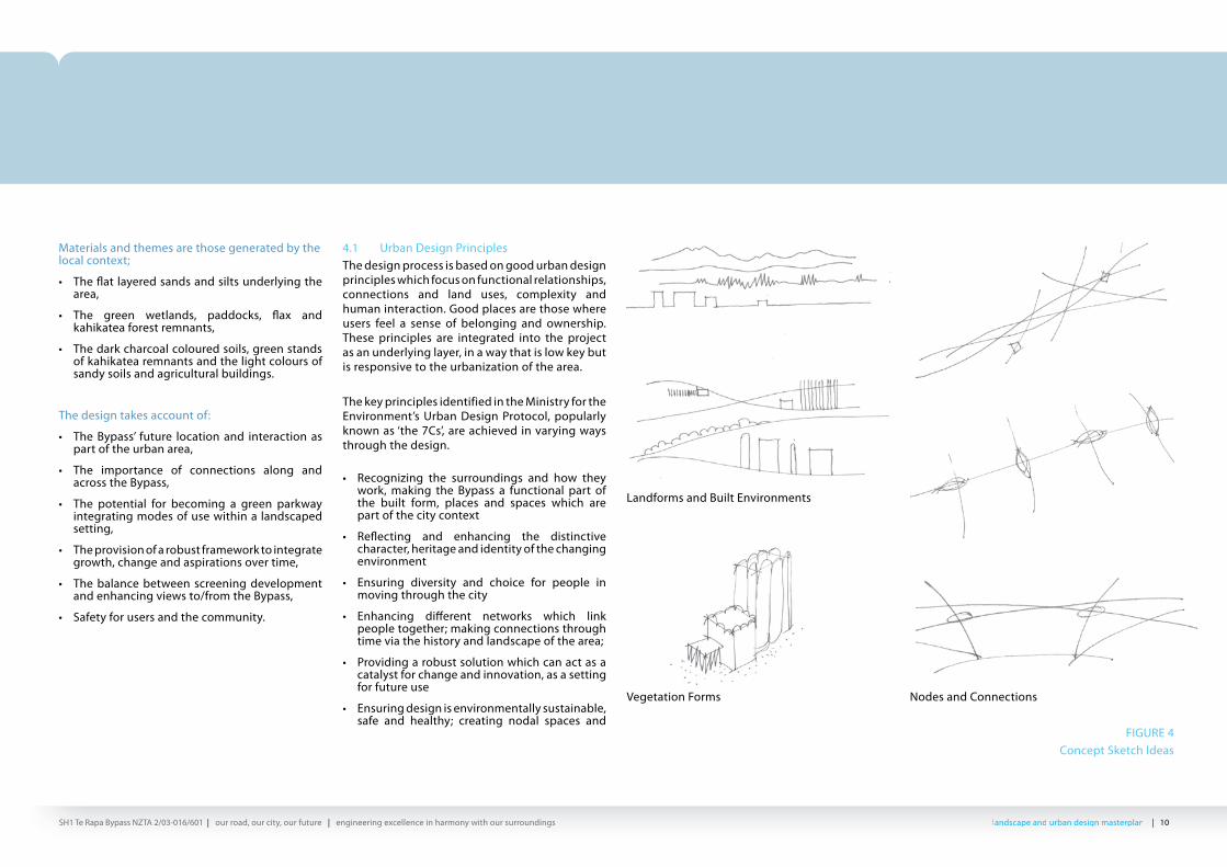
Materials and themes are those generated by the local context;
• The fl at layered sands and silts underlying the area,
• The green wetlands, paddocks, fl ax and kahikatea forest remnants,
• The dark charcoal coloured soils, green stands of kahikatea remnants and the light colours of sandy soils and agricultural buildings.
The design takes account of:
• The Bypass’ future location and interaction as part of the urban area,
• The importance of connections along and across the Bypass,
• The potential for becoming a green parkway integrating modes of use within a landscaped setting,
• The provision of a robust framework to integrate growth, change and aspirations over time,
• The balance between screening development and enhancing views to/from the Bypass,
• Safety for users and the community.
4.1 Urban Design Principles The design process is based on good urban design principles which focus on functional relationships, connections and land uses, complexity and human interaction. Good places are those where users feel a sense of belonging and ownership. These principles are integrated into the project as an underlying layer, in a way that is low key but is responsive to the urbanization of the area. The key principles identified in the Ministry for the Environment’s Urban Design Protocol, popularly known as ‘the 7Cs’, are achieved in varying ways through the design.
• Recognizing the surroundings and how they work, making the Bypass a functional part of the built form, places and spaces which are part of the city context
• Refl ecting and enhancing the distinctive character, heritage and identity of the changing environment
• Ensuring diversity and choice for people in moving through the city
• Enhancing diff erent networks which link people together; making connections through time via the history and landscape of the area;
• Providing a robust solution which can act as a catalyst for change and innovation, as a setting for future use
• Ensuring design is environmentally sustainable, safe and healthy; creating nodal spaces and
routes which people will espouse
• Communicating and sharing knowledge, working collaboratively in achieving the project.
FIGURE 4 Concept Sketch Ideas
Landforms and Built Environments
Vegetation Forms Nodes and Connections
landscape and urban design masterplan | 11SH1 Te Rapa Bypass NZTA 2/03-016/601 | our road, our city, our future | engineering excellence in harmony with our surroundings lllala ddndndscscapape e ananddd d ururbbbaban n dddede iisisigngn m masasttteterprplllalann | 11SH1 Te Rapa Bypass NZTA 2/03-016/601 | our road, our city, our future | engineering excellence in harmony with our surroundings
4.2 Connections/Open Space StrategyFundamental to any roading project is the ability to provide connections, for vehicular and other modes of travel, to provide ways in which land uses can achieve the rich mix which is an integral part of urban development and community.
Much of this patterning has already been established through the form of the designated route, facilitating the future growth of the Rotokauri area, through the Rotokauri Structure Plan, and the future Horotiu Structure Plan discussions. Ancillary to this is the HCC proposed cycling and walkway strategy and the aspirations of the City Gateway Policy. These proposals form an integral part of the design response of the Bypass
A key element of the design vision is the establishment of nodes, where local and arterial roads meet, particularly related to the route of the cycleway. These “pocket parks” can be connected to the wider community open space network as the area develops They will provide stopping points on an extended cycleway/green corridor and include where local roads have been terminated. Open space connections and green streetscapes for local roads can also extend from this framework, spreading out into the surrounding community.
WAIKATO RIVER
AVALON DR
TE RAPA BYPASSHOROTIU
FARM PARK
ROTOKAURI STRUCTURE PLAN
LAKE ROTOKAURI
FIGURE 5 Open Space Connections
KEY
FUTURE NODES
PROPOSED NODES
GREEN SPACES
landscape and urban design masterplan | 12SH1 Te Rapa Bypass NZTA 2/03-016/601 | our road, our city, our future | engineering excellence in harmony with our surroundings ll l lanandddsdscacapepe a a ddndnd u u bbrbrbanan dd d desesiiigign n mama ttststerer llplplanan | 12SH1 Te Rapa Bypass NZTA 2/03-016/601 | our road, our city, our future | engineering excellence in harmony with our surroundings
4.3 Design CharacterThe design approach utilises a simple, robust and bold planting palette to reinforce the variety and character of patterns found within the area. The design layout reflects the areas patterns and the broader character of the area, utilising block planting, linear drainage swales and locally sourced native plant material to provide a cohesive design approach.
In particular, the design character reflects the field patterns and existing remnants of kahikatea and native block planting that is found within the region. This form has been applied along the Bypass, utilising predominantly native plant species in simple bold block forms. The scheme also utilises mass planting of exotic trees to identify node areas and reflect the cultural influences on the land. It is intended that the tree planting will provide the framework to allow incorporation of trees into the future roads and development, therefore enhancing the character of the area.
FIGURE 6 Initial Design Concept
WAIKATO RIVER
AVALON DR
HOROTIU
ROTOKAURI STRUCTURE PLAN
LAKE ROTOKAURI
FARM PARK
TE RAPA BYPASS
KEY
NODE BLOCK PLANTING
PLANTING BANDS
GREEN SPACES
Pacifi c Migration Stick Map
landscape and urban design masterplan | 13SH1 Te Rapa Bypass NZTA 2/03-016/601 | our road, our city, our future | engineering excellence in harmony with our surroundings lllala ddndndscscapape e ananddd d ururbbbaban n dddede iisisigngn m masasttteterprplllalann | 13SH1 Te Rapa Bypass NZTA 2/03-016/601 | our road, our city, our future | engineering excellence in harmony with our surroundings
4.4 Integrated Design ApproachThe Landscape and Urban Design team has worked closely with other disciplines to achieve an integrated design approach. The team includes Landscape Architects, Urban Designers, Storm water Engineer, Ecologist and Structural Architects. Working in the same office has allowed for a seamless design approach that is bold, innovative, practical and cost effective.
This positive interaction has enabled the design team to co-ordinate all the various aspects of the design requirements, seamlessly integrating drainage swales with ecological planting, cycle routes which link to the broader area and provision of maintenance corridors. Landscape planting has been designed to allow future road connections to be integrated into the scheme without the loss of significant vegetation.
The landscape elements within the scheme are simple and robust, that will allow the scheme to be implemented with a high degree of practicality and build-ability and attributes the benefit of relative ease of maintenance in the longer term.
landscape and urban design masterplan | 14SH1 Te Rapa Bypass NZTA 2/03-016/601 | our road, our city, our future | engineering excellence in harmony with our surroundings ll l lanandddsdscacapepe a a ddndnd u u bbrbrbanan dd d desesiiigign n mama ttststerer llplplanan | 14SH1 Te Rapa Bypass NZTA 2/03-016/601 | our road, our city, our future | engineering excellence in harmony with our surroundings
4.5 Ecology, Biodiversity and SustainabilityThese three elements are very much tied together and have been considered as interrelated issues which form the basis of the planting design. Our approach has been to provide a context sensitive solution in the surrounding landscape, linking together scattered patches of vegetation wherever possible, to increase biodiversity and create a long term self managing system. This will achieve a green corridor along the bypass route which can provide an attractive off road cycle/pedestrian environment as part of a wider network that will help reduce vehicle use.
The selection and combination of planting material will assist in enhancing the wildlife opportunities of the site and provide biodiversity within the area. Plant choices will benefit the area through:
• Enrichment planting around remnants on waterways (as at Bern Road),
• Use of eco-sourced native species local to the area,
• Inclusion of stands of podocarp species which provide rich food source for birds, as well, as roosting/ nesting points within the Bypass corridor,
• Inclusion of nectar rich species such as fl ax and kowhai,
• Planting swales to provide shade for damp/wet areas to enhance plant and wildlife opportunities.
• In taking this approach we have realised the potential to increase biodiversity and enhance ecological outcomes with a context
sensitive, integrated stormwater, open space and landscape design. This approach will be developed further at the next stage by:
• Field identifi cation of any vegetation outside scope of works but within the designation, for eradication or protection, including identifi cation of problem weed species prior to stripping topsoil,
• Development of environmental management plans in liaison with HCC, WDC and Environment Waikato,
• Liaison with HCC, WDC and EW on best practice related to biosecurity issues,
• Other environmental enhancement may include hibernacula (stacked logs for insect habitat) and bird boxes to enhance wild life habitat.
Additional sustainable approaches that have been considered and integrated into the design where possible will assist in reducing costs as well as providing environmental benefits. These measures include:
• he stripping, stockpiling and reuse of topsoil for the entire project, which will avoid the importation of topsoil, resulting in reduced machinery movements and therefore reduced environmental costs,
• Use of recycle materials, including incorporating crushed glass in paving, and use of log peelings as environmentally friendly bark mulch,
• Utilisation of low growth grass varieties to reduce the mowing requirements and therefore minimise machinery use,
• Consideration to standard mowing zones to suit industry standard mowers and therefore reducing mowing regimes and the carbon foot
print.
FIGURE 7Planting Concept
landscape and urban design masterplan | 15SH1 Te Rapa Bypass NZTA 2/03-016/601 | our road, our city, our future | engineering excellence in harmony with our surroundings lllala ddndndscscapape e ananddd d ururbbbaban n dddede iisisigngn m masasttteterprplllalann | 15SH1 Te Rapa Bypass NZTA 2/03-016/601 | our road, our city, our future | engineering excellence in harmony with our surroundings
4.6 Integrated Storm Water Design SolutionsThe proposed storm water treatment design, utilising continuous swales which run along the length of the Bypass located at the toe of the embankments. It has the potential to be a significant feature in the green network, with connections to existing waterways in the area, and also providing educational points along the future cycle and walkways. These will also provide an opportunity to develop habitats and recreate a riparian corridor. There is little existing vegetation which can form a nucleus of such a corridor, though the small remnant area of Bern Road culvert will be safeguarded where possible with provision of fish passage and protection of existing flora and fauna carefully considered.
The planting design is based around Waikato riverbank and wetland species, fine tuned to meet the constructed site conditions. The base of swales will be planted with native grass/reed species, tolerant of damp and dry that will also perform under flood conditions. These plants will trap sediment and add a polishing element to storm water treatment, prior to joining the Waikato River.
Incorporating planting on the toe and sides of batter slopes will increase the area of potential habitat, providing a sequence from wetland to dry land community. Where possible, swales will be shaped to further increase the range of planting and create a more naturalised “stream” environment.
In the areas which will be wetter, tree species will be located along the banks, to provide shade on the margins, which can be supplemented with logs or stones to create habitat niches.
We will develop more detailed ecological outcomes at the next stage, by looking for additional opportunities for wetland/riparian development in conjunction with the Bern Road culvert, and fine tuning planting treatments to support habitats where farm drainage and treatment swale systems merge. Consideration has been given to:
• The need for easy maintenance of the storm water system,
• The range of ground conditions,
• The opportunity to create ecological gain through riparian and wetland planting,
• The potential of the corridor to be part of the open space network of the area,
• The width of grassed swales, to be easily mowable.
FIGURE 8Swale Concept
landscape and urban design masterplan | 16SH1 Te Rapa Bypass NZTA 2/03-016/601 | our road, our city, our future | engineering excellence in harmony with our surroundings ll l lanandddsdscacapepe a a ddndnd u u bbrbrbanan dd d desesiiigign n mama ttststerer llplplanan | 16SH1 Te Rapa Bypass NZTA 2/03-016/601 | our road, our city, our future | engineering excellence in harmony with our surroundings
4.7 Innovative SolutionsInnovation has been identified as a key objective for this project. Some of the innovative measures considered in developing the Project are listed below:• Taking a proactive approach in linking roads
and non vehicular routes to provide a long term legacy through pocket park nodes, enriching the Bypass legacy,
• Establishing a planting matrix and design which provides a framework for future change and is a contributor to the local street network,
• Utilisation of a simple palette of plant material, which is suited to the growing conditions and therefore likely to establish and thrive. This approach provides lower costs through the large scale of production and ease of implementation,
• Topsoil will be re-utilised from that stripped from the site, avoiding the need and cost of importing topsoil,
• Integration of storm water swales to recharge aquifers where possible and reduce water fl ows and making these part of a continuous ecological corridor,
• Integration of safety features and educational information boards into the cycle and walkways,
• Use of podocarp tree species which provide a well known food source to attract birds,
• Promoting ecological diversity by integrating hibernacula along the Bypass corridor,
• Reduction of mowing regimes and costs by utilising low grow grass species and utilising defi ned grass widths which match industry standard machinery.
Other innovative solutions that could be introduced at the detail stage may include utilising bare root stock trees and shrubs and utilising plant plugs or rhizomes for the swales to reduce costs, and promote establishment and different low grow grass species for difficult growing areas.
4.8 Local StakeholdersAs part of the concept design process, the design team has identified and meet with a number of key stakeholders. The design team has considered a variety of suggestions as part of the design process.
Ongoing consultation shall be an important part of the detailed design and implementation process and will be essential for obtaining and finalising management plans and compliance with environmental consent requirements. We will be taking part in the development of the ongoing consultation strategy to ensure clear lines of communication with stakeholders, to achieve a successful outcome.
The key stakeholders include the following:
• Hamilton City Council (HCC)• Waikato District Council• Iwi• Environment Waikato• Wintec• Local Residents• Lake Waiwhakareke group
The team will liaise with immediate landowners whose land is affected, to determine appropriate agreed landscape design measures, to mitigate the effects of the Bypass on individual properties. In addition, consultation with key stakeholders will be undertaken to ensure the proposals co-ordinate and are in line with their objectives. In particular, we consider building on existing relationships with iwi, Hamilton City Council, Waikato District Council and Environment Waikato to be vital for the success of the project.
4.9 Cost Effective Design Benefits
In addition to established cost effective processes, we have reviewed our design to consider sustainability, in particular:• Maximum recycling of material on site, with
reuse of materials where possible,
• Nil importation of topsoil,
• Balance of planting to grassing costs,
• Use of cost eff ective mulch from local sources,
• Optimal sizing of plants related to performance,
• Sources of hard materials, and comparison of these with soft,
• Potential for community involvement, to reduce vandalism,
• Communication to develop “feel good” acceptance and support for the project.
landscape and urban design masterplan | 17SH1 Te Rapa Bypass NZTA 2/03-016/601 | our road, our city, our future | engineering excellence in harmony with our surroundings lllala ddndndscscapape e ananddd d ururbbbaban n dddede iisisigngn m masasttteterprplllalann | 17SH1 Te Rapa Bypass NZTA 2/03-016/601 | our road, our city, our future | engineering excellence in harmony with our surroundings
5 DESIGN ELEMENTS
The materials palette has been developed by investigating the textures, forms, colours and materials from the local landscape. By using local materials the local identity and character is retained and enhanced allowing opportunities for travellers to learn about the past landscape. To reflect the rural and industrial surrounds a simple and robust selection of materials will be utilised. The main palette of material will include ‘chunky’ timber seats, safety railings and simple, low cost paving units. The materials will be used to introduce design patterns which reflect the physical and cultural elements found within the area, therefore reinforcing the scheme’s character.
Materials will be reflected through planting patterns, bridge abutments and node interventions. The palette will also become the basis for developing the public art intervention brief.
The material, textures and patterns can be defined as follows:
Patterns and forms
• Lines and mesh of field patterns and drains,• Tall blocks of Kahikatea forest remnants,• Lines and layers of the geology and land form,• Lines of the roads, rail and river forms,• Lines and mesh of fl ax weave baskets and pui
pui skirts,
• Rectilinear forms of industrial and farm buildings,
Colours
• Dark green – Kahikatea forest
• Bright green – wetland planting
• Rusty steel – railway
• Cream – Hinurea stone
• Grey green -lichened fence posts
• White – of industrial buildings
Materials
• Hinuera stone
• Timber railway sleepers
• Exposed aggregate concrete
• Textured paving units
• Steel fencing wire
landscape and urban design masterplan | 18SH1 Te Rapa Bypass NZTA 2/03-016/601 | our road, our city, our future | engineering excellence in harmony with our surroundings ll l lanandddsdscacapepe a a ddndnd u u bbrbrbanan dd d desesiiigign n mama ttststerer llplplanan | 18SH1 Te Rapa Bypass NZTA 2/03-016/601 | our road, our city, our future | engineering excellence in harmony with our surroundings
5.2 PlantingThe planting concept is essential to building a strong design plus create the parameters for the future development along the Bypass. The scheme will create the Hamilton Greenway and includes large scale block planting mixes of low growth grass, native shrub mix plantings, revegetation and exotic specimen trees to define the character.
In terms of urban design, large stands or small groups of trees specifically located can greatly assist way-finding within urban landscapes, by providing visual cues to locations. This approach is being used at the local road overbridges and at the pocket park nodes on the cycleway. These small but carefully detailed areas use cabbage trees as a repeating element and theme for the cycleway, creating way-finding markers linking rest spots along the cycle way.
Cultural and ecological importance of the planting includes the use of kowhai, and kahikatea, which will be incorporated into the planting scheme as bold planting areas along the bypass margins. This will tie into the Hamilton ‘Halo’ project which aims at bringing back native birds, particularly tui into Hamilton. The planting of kowhai identifies with Hamilton and the Waikato and kahikatea establishes tall ‘staging posts’ and a rich source of podocarp fruit, creating a feeding corridor through the surrounding area.
The planting palette achieves;
• a plant selection refl ects the local species composition and cultural landscapes of the surrounding area and will, in time, contribute and feature strongly in the local landscape,
• the selection of native plant material has been co-ordinated and selected with reference to plant material utilised at Horseshoe Lake (Lake Waiwhakareke), also taking account of its likely success in the road’s environment. All native plant material will be eco-sourced from as close to site as possible,
• exotic trees have been included to refl ect the ‘garden city‘ of Hamilton, to increase diversity of food sources and provide robust and suitable planting for the site conditions,
• The design of planting blocks/bands with specifi c planting mixes will allow plantings to naturally develop, provide some seed source to a currently impoverished area, and allow the enrichment of habitats over time.
Tree protection of existing trees within the designation zone will be undertaken during the construction period. Currently there are a limited number of trees that have been identified for retention. These areas will be protected with tree protection fencing, to provide a ‘no go’ zone within the tree canopy areas to ensure the limited remnants are maintained in optimal health.
planting cross section
FIGURE 9Typical Road Planting Sketch
landscape and urban design masterplan | 19SH1 Te Rapa Bypass NZTA 2/03-016/601 | our road, our city, our future | engineering excellence in harmony with our surroundings lllala ddndndscscapape e ananddd d ururbbbaban n dddede iisisigngn m masasttteterprplllalann | 19SH1 Te Rapa Bypass NZTA 2/03-016/601 | our road, our city, our future | engineering excellence in harmony with our surroundings
Block mass plantingsThe planting design reflects the patterned nature of the landscape and utilises blocks of planting, comprising in general three native species, selected to provide a hierarchy of cover; interim and long term species. This is proposed to allow for rapid growth of the initial species, to promote shading and shelter, while allowing longer term species to establish and dominate. This staggering of growth will provide attractive complexity of planting throughout the design.
The mixes also allow robustness in being selected to manage the changing ground conditions from natural soil to dry batter slopes. Therefore, planting has been designed to allow a change of the mix species to suit the growing conditons.
Planting mixes will be matched on both sides of the Bypass giving continuity to the planting scheme. The relative height of mixes has been carefully placed to optimise views and provide screening where necessary. The intensity of plantings also generates a rhythm along the Bypass, wider spaced in the rural areas and getting more intense closer to the city to reflect the smaller scale urban planting patterns
landscape and urban design masterplan | 20SH1 Te Rapa Bypass NZTA 2/03-016/601 | our road, our city, our future | engineering excellence in harmony with our surroundings ll l lanandddsdscacapepe a a ddndnd u u bbrbrbanan dd d desesiiigign n mama ttststerer llplplanan | 20SH1 Te Rapa Bypass NZTA 2/03-016/601 | our road, our city, our future | engineering excellence in harmony with our surroundings
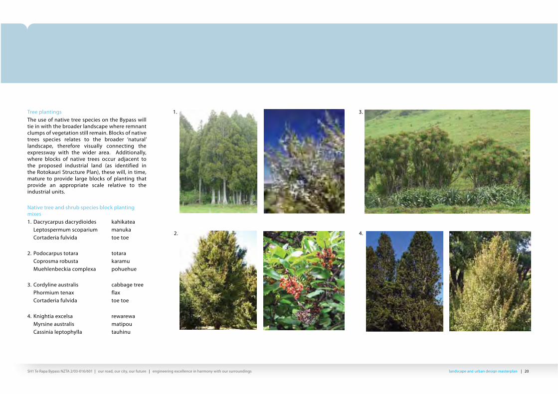
Tree plantingsThe use of native tree species on the Bypass will tie in with the broader landscape where remnant clumps of vegetation still remain. Blocks of native trees species relates to the broader ‘natural’ landscape, therefore visually connecting the expressway with the wider area. Additionally, where blocks of native trees occur adjacent to the proposed industrial land (as identified in the Rotokauri Structure Plan), these will, in time, mature to provide large blocks of planting that provide an appropriate scale relative to the industrial units.
Native tree and shrub species block planting mixes1. Dacrycarpus dacrydioides kahikatea Leptospermum scoparium manuka Cortaderia fulvida toe toe
landscape and urban design masterplan | 21SH1 Te Rapa Bypass NZTA 2/03-016/601 | our road, our city, our future | engineering excellence in harmony with our surroundings lllala ddndndscscapape e ananddd d ururbbbaban n dddede iisisigngn m masasttteterprplllalann | 21SH1 Te Rapa Bypass NZTA 2/03-016/601 | our road, our city, our future | engineering excellence in harmony with our surroundings
Development of storm water plantings as a linear thread through the design will blend in with the adjacent planting mixes. Species have been chosen which will withstand the range of growing condition, from flood to summer drought, which will occur in parts of the system. These will be primarily a reed type in the wetter lower areas and a Carex type on the margins. Both will lie flat in flood flows and withstand limited periods of inundation.Species such as flax and Cabbage trees (harakeke and te kouka) will be located above flood zones to prevent interruption of flood flows. Taller species on batter slopes will provide some shade and enrich the swale habitat as it develops.
landscape and urban design masterplan | 22SH1 Te Rapa Bypass NZTA 2/03-016/601 | our road, our city, our future | engineering excellence in harmony with our surroundings ll l lanandddsdscacapepe a a ddndnd u u bbrbrbanan dd d desesiiigign n mama ttststerer llplplanan | 22SH1 Te Rapa Bypass NZTA 2/03-016/601 | our road, our city, our future | engineering excellence in harmony with our surroundings
Exotic treesExotic trees will also be utilised as a visual and physical reference at the node points of existing and proposed roading networks. These are chosen to provide greater variety of form, colour and flower, and are suitable for use as street trees to extend along the suburban streets. The intent is to utilise these as a framework to allow the tree species to be utilised along the Bypass corridor, in turn, strengthen the connections of the scheme to the wider landscape. Lines of trees will visually lead the eye across the road, providing a continuous linking element to the Bypass.
1. 3. 5.
4. 6.2.Specimen tree species1. Fraxinus excelsior Ash 2. Quercus palustris Pin oak3. Quercus robur ‘Fastigiata’ Upright Oak4. Platanus x hispanica London Plane5. Tilia platyphyllos ‘Laciniata’ Upright Silver Linden6. Tilia cordata ‘Greenspire’ Lime Tree
landscape and urban design masterplan | 23SH1 Te Rapa Bypass NZTA 2/03-016/601 | our road, our city, our future | engineering excellence in harmony with our surroundings lllala ddndndscscapape e ananddd d ururbbbaban n dddede iisisigngn m masasttteterprplllalann | 23SH1 Te Rapa Bypass NZTA 2/03-016/601 | our road, our city, our future | engineering excellence in harmony with our surroundings
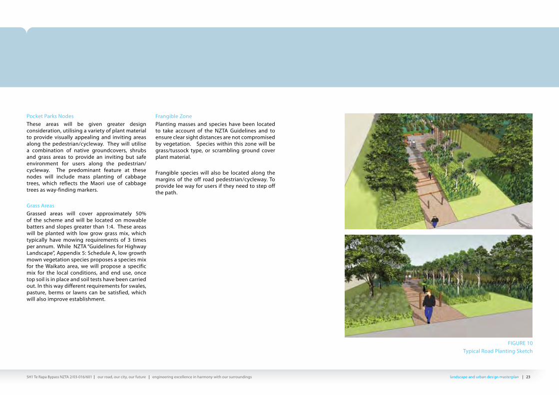
Pocket Parks NodesThese areas will be given greater design consideration, utilising a variety of plant material to provide visually appealing and inviting areas along the pedestrian/cycleway. They will utilise a combination of native groundcovers, shrubs and grass areas to provide an inviting but safe environment for users along the pedestrian/cycleway. The predominant feature at these nodes will include mass planting of cabbage trees, which reflects the Maori use of cabbage trees as way-finding markers.
Grass AreasGrassed areas will cover approximately 50% of the scheme and will be located on mowable batters and slopes greater than 1:4. These areas will be planted with low grow grass mix, which typically have mowing requirements of 3 times per annum. While NZTA “Guidelines for Highway Landscape”, Appendix 5: Schedule A, low growth mown vegetation species proposes a species mix for the Waikato area, we will propose a specific mix for the local conditions, and end use, once top soil is in place and soil tests have been carried out. In this way different requirements for swales, pasture, berms or lawns can be satisfied, which will also improve establishment.
Frangible ZonePlanting masses and species have been located to take account of the NZTA Guidelines and to ensure clear sight distances are not compromised by vegetation. Species within this zone will be grass/tussock type, or scrambling ground cover plant material.
Frangible species will also be located along the margins of the off road pedestrian/cycleway. To provide lee way for users if they need to step off the path.
FIGURE 10Typical Road Planting Sketch
landscape and urban design masterplan | 32SH1 Te Rapa Bypass NZTA 2/03-016/601 | our road, our city, our future | engineering excellence in harmony with our surroundings ll l lanandddsdscacapepe a a ddndnd u u bbrbrbanan dd d desesiiigign n mama ttststerer llplplanan | 32SH1 Te Rapa Bypass NZTA 2/03-016/601 | our road, our city, our future | engineering excellence in harmony with our surroundings
5.5 Pedestrian & cyclewayOpen space connections are an important aspect of the landscape and urban design master plan and for sustainable transport networks. The creation of well linked open spaces encourages recreational activities while strengthen connectivity and accessibility for future developments.
As part of the Principal Requirements, a shared pedestrian and cycle way has been incorporated into the scheme. The pedestrian footpath and cycleway has been located as per the recommendations from Draft Walking and Cycling Strategy Te Rapa Bypass report, prepared by Bloxam Burnett & Oliver (BBO).
In addition to providing a continuous access route, the scheme design has incorporated a number of open space nodes along the pedestrian/cycleway. The nodes are located at the start of the path, at proposed local road intersections and the central interchange. These provide well designed, safe stopping points with seating, location for art work and incorporation of open grass areas and appropriately scaled planting.
5.6 Site FurnitureThis will meet the engineering standards required for the project. Recycled material will be used at the cycleway nodes for surfacing and to provide informal seating. Discussions will be held with HCC to integrate plans with any signage for information requirements they may have, as part of their cycleway strategy network.
FIGURE 25 Typical Walkway and Cycleway Cross Section
landscape and urban design masterplan | 33SH1 Te Rapa Bypass NZTA 2/03-016/601 | our road, our city, our future | engineering excellence in harmony with our surroundings lllala ddndndscscapape e ananddd d ururbbbaban n dddede iisisigngn m masasttteterprplllalann | 33SH1 Te Rapa Bypass NZTA 2/03-016/601 | our road, our city, our future | engineering excellence in harmony with our surroundings
6. CONCEPT PLANS
FIGURE 26Local Bridge Node and Planting Concept
landscape and urban design masterplan | 34SH1 Te Rapa Bypass NZTA 2/03-016/601 | our road, our city, our future | engineering excellence in harmony with our surroundings
6 Concept Plans
scale NTS @ A314 December 2009
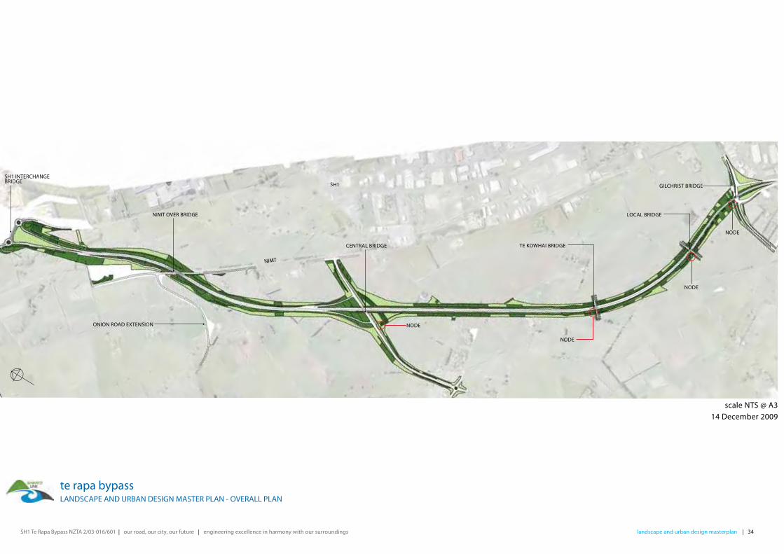
te rapa bypass LANDSCAPE AND URBAN DESIGN MASTER PLAN - OVERALL PLAN
SH1 INTERCHANGEBRIDGE
NIMT OVER BRIDGE
ONION ROAD EXTENSION
CENTRAL BRIDGE
NODE
NODE
SH1
NIMT
TE KOWHAI BRIDGE
LOCAL BRIDGE
GILCHRIST BRIDGE
NODE
NODE
SH1 Te Rapa Bypass NZTA 2/03-016/601 | our road, our city, our future | engineering excellence in harmony with our surroundings
scale 1:4000 @ A314 December 2009
te rapa bypass LANDSCAPE AND URBAN DESIGN CONCEPT PLAN - PLAN 1 OF 14
OLD SH1 (LOCAL ROAD)
OLD SH1 (LOCAL ROAD)
BERN ROAD
POND
landscape and urban design masterplan | 35
IF BERN ROAD IS CLOSED
CAREX
FUTURE TREE PLANTING FUTURE TREE PLANTING
CAREX
MUEHLENBECKIA
SH1 INTERCHANGEBRIDGE
MUEHLENBECKIA
ANEMANTHELE
CABBAGE TREE, FLAXAND TOE TOE MIX
TOE TOE TOE TOE
HARAKEKE
GRASS
SWALE PLANTING/GRASS
SINGLE SPECIES PLANTING
BLOCK NATIVE PLANTING
SPECIMEN TREE PLANTING
KEY
WALKWAY AND CYCLEWAY
FUTURE WALKWAY AND CYCLEWAY
DESIGNATION BOUNDARY
JOIN
LIN
EJO
IN L
INE
landscape and urban design masterplan | 36SH1 Te Rapa Bypass NZTA 2/03-016/601 | our road, our city, our future | engineering excellence in harmony with our surroundings
scale 1:4000 @ A314 December 2009
te rapa bypass LANDSCAPE AND URBAN DESIGN MASTER PLAN - PLAN 2 OF 14
BERN RO
AD
NIMT RAILWAY
ONION ROAD EXTENSION
IF BERN ROAD IS CLOSED
HARAKEKE
HARAKEKE
WETLAND PLANTING
CABBAGE TREE, FLAXAND TOE TOE MIX
KAHIKATEA, MANUKAAND TOE TOE MIX
NIMT OVERBRIDGE
HARAKEKEPOHUEHUE
AMANANTHELE
GRASS
SWALE PLANTING/GRASS
SINGLE SPECIES PLANTING
BLOCK NATIVE PLANTING
SPECIMEN TREE PLANTING
KEY
WALKWAY AND CYCLEWAY
FUTURE WALKWAY AND CYCLEWAY
DESIGNATION BOUNDARY
JOIN
LIN
E
JOIN
LIN
E
JOIN
LIN
EJO
IN L
INE
SH1 Te Rapa Bypass NZTA 2/03-016/601 | our road, our city, our future | engineering excellence in harmony with our surroundings
NIMT RAILWAY
ONION ROAD EXTENSION ON
ION
ROA
D
ON
ION
ROA
D
ONION ROAD REALIGNMENT
scale 1:4000 @ A314 December 2009
te rapa bypass LANDSCAPE AND URBAN DESIGN MASTER PLAN - PLAN 3 OF 14
landscape and urban design masterplan | 37
3.2M WIDE GRASSED SERVICE CORRIDOR
PITTOSPORUM CABBAGE TREE, FLAXAND TOE TOE MIX
KOWHAI, TOE TOEAND COROKIA MIX
HEKETARA
HARAKEKE
EXTENT OF SERVICE CORRIDOR
NIMT OVERBRIDGE
ONION ROADTERMINATION
ONION ROADTERMINATION
GRASS
SWALE PLANTING/GRASS
SINGLE SPECIES PLANTING
BLOCK NATIVE PLANTING
SPECIMEN TREE PLANTING
KEY
WALKWAY AND CYCLEWAY
FUTURE WALKWAY AND CYCLEWAY
DESIGNATION BOUNDARY
JOIN
LIN
EJO
IN L
INE
JOIN
LIN
EJO
IN L
INE
landscape and urban design masterplan | 38SH1 Te Rapa Bypass NZTA 2/03-016/601 | our road, our city, our future | engineering excellence in harmony with our surroundings
CENTRAL ROAD
scale 1:4000 @ A314 December 2009
te rapa bypass LANDSCAPE AND URBAN DESIGN MASTER PLAN - PLAN 4 OF 14
CABBAGE TREE, HARAKEKEAND TOE TOE MIX
TOE TOE
3.2M WIDE GRASSED SERVICE CORRIDOR
KAHIKATEA, MANUKAAND TOE TOE MIX
KOWHAI, TOE TOEAND COROKIA MIX
CAREX
CAREX
CENTRAL BRIDGE
HARAKEKE
TOTARA, KARAMU AND MUEHLENBECKIA MIX
3.2M WIDE GRASSED SERVICE CORRIDOR
GRASS
SWALE PLANTING/GRASS
SINGLE SPECIES PLANTING
BLOCK NATIVE PLANTING
SPECIMEN TREE PLANTING
KEY
WALKWAY AND CYCLEWAY
FUTURE WALKWAY AND CYCLEWAY
DESIGNATION BOUNDARY
JOIN
LIN
EJO
IN L
INE
JOIN
LIN
EJO
IN L
INE
SH1 Te Rapa Bypass NZTA 2/03-016/601 | our road, our city, our future | engineering excellence in harmony with our surroundings
CENTRAL ROAD
RUFFELL ROAD
RUFFELL ROAD
scale 1:4000 @ A314 December 2009
te rapa bypass LANDSCAPE AND URBAN DESIGN MASTER PLAN - PLAN 5 OF 14
HEKETARA
TOTARA, KARAMU AND MUEHLENBECKIA MIX
landscape and urban design masterplan | 39
WALKWAY AND CYCLEWAY NODE
RUFFELL ROAD TERMINATION
RUFFELL ROAD TERMINATION
REWAREWA, RED MATIPOU AND TAUHINU
KAHIKATEA, MANUKA AND TOTOE MIX
RUFFELL ROAD
RUFFELL ROAD
KOROMIKO TOTARA, KARAMU AND MUEHLENBECKIA MIX
3.2M WIDE GRASSED SERVICE CORRIDOR
3.2M WIDE GRASSED SERVICE CORRIDOR
TOE TOE
MUEHLENBECKIA
GRASS
SWALE PLANTING/GRASS
SINGLE SPECIES PLANTING
BLOCK NATIVE PLANTING
SPECIMEN TREE PLANTING
KEY
WALKWAY AND CYCLEWAY
FUTURE WALKWAY AND CYCLEWAY
DESIGNATION BOUNDARY
JOIN
LIN
EJO
IN L
INE
JOIN
LIN
EJO
IN L
INE
landscape and urban design masterplan | 40SH1 Te Rapa Bypass NZTA 2/03-016/601 | our road, our city, our future | engineering excellence in harmony with our surroundings
TE KOWHAI ROAD
RUFFELL ROAD
scale 1:4000 @ A314 December 2009te rapa bypass
LANDSCAPE AND URBAN DESIGN MASTER PLAN - PLAN 6 OF 14
4.8M WIDE GRASSEDSERVICE CORRIDOR
3.2M WIDE GRASSEDSERVICE CORRIDOR
TE KOWHAI ROADTERMINATION
TE KOWHAI ROAD AND RUFFELL ROAD TERMINATION
KAHIKATEA, MANUKAAND TOE TOE MIX
CAREX
TOTARA, KARAMUAND MUEHLENBECKIA MIX
PITTOSPORUMKOWHAI, TOE TOEAND COROKIA MIX
TE KOWHAI ROAD
GRASS
SWALE PLANTING/GRASS
SINGLE SPECIES PLANTING
BLOCK NATIVE PLANTING
SPECIMEN TREE PLANTING
KEY
WALKWAY AND CYCLEWAY
FUTURE WALKWAY AND CYCLEWAY
DESIGNATION BOUNDARY
JOIN
LIN
E
JOIN
LIN
E
JOIN
LIN
EJO
IN L
INE
SH1 Te Rapa Bypass NZTA 2/03-016/601 | our road, our city, our future | engineering excellence in harmony with our surroundings
scale 1:4000 @ A314 December 2009
te rapa bypass LANDSCAPE AND URBAN DESIGN MASTER PLAN - PLAN 7 OF 14
landscape and urban design masterplan | 41
KOWHAI, TOE TOE AND COROKIA MIX
TOE TOE
KOWHAI, TOE TOE AND COROKIA MIX
WALKWAY AND CYCLEWAY NODE
POSSIBLE FUTUREPLANTING
TE KOWHAI BRIDGE
3.2M WIDE GRASSED SERVICE CORRIDOR
CABBAGE TREE, FLAX AND TOE TOE MIX
KOROMIKO CAREX
KOROMIKO CAREX
KOROMIKO CAREXCAREX
KAHIKATEA, MANUKAAND TOE TOE MIX
LANCEWOOD, HEKETARAAND TUSSOCK GRASS MIX
REWAREWA, RED MATIPOU AND TAUHINU MIX
WALKWAY AND CYCLEWAYUNDER BRIDGE AND CONNECTSWITH WESTERN PATHWAY
GRASS
SWALE PLANTING/GRASS
SINGLE SPECIES PLANTING
BLOCK NATIVE PLANTING
SPECIMEN TREE PLANTING
KEY
WALKWAY AND CYCLEWAY
FUTURE WALKWAY AND CYCLEWAY
DESIGNATION BOUNDARY
JOIN
LIN
E
JOIN
LIN
E
JOIN
LIN
E
JOIN
LIN
E
landscape and urban design masterplan | 42SH1 Te Rapa Bypass NZTA 2/03-016/601 | our road, our city, our future | engineering excellence in harmony with our surroundings
scale 1:4000 @ A314 December 2009
te rapa bypass LANDSCAPE AND URBAN DESIGN MASTER PLAN - PLAN 8 OF 14
TOTARA, KARAMU ANDMIX
CAREX MUEHLENBECKIA
PITTOSPORUM
HARAKEKE TOE TOE
KOWHAI, TOE TOEAND COROKIA MIX
KOWHAI, TOE TOEAND COROKIA MIX
TOE TOE
3.2M WIDE GRASSED SERVICE CORRIDOR
AMANANTHELEAMANANTHELE MUEHLENBECKIA
KOROMIKOHEKETARAFUTURE LOCAL ROAD BRIDGE
WALKWAY AND CYCLEWAY NODE
POSSIBLE FUTUREPLANTING
LOCAL BRIDGE
CABBAGE TREE, FLAX AND TOE TOE MIX
TOTARA, KARAMU AND MUEHLENBECKIA MIX
GRASS
SWALE PLANTING/GRASS
SINGLE SPECIES PLANTING
BLOCK NATIVE PLANTING
SPECIMEN TREE PLANTING
KEY
WALKWAY AND CYCLEWAY
FUTURE WALKWAY AND CYCLEWAY
DESIGNATION BOUNDARY
JOIN
LIN
E
JOIN
LIN
E
JOIN
LINE
JOIN
LINE
landscape and urban design masterplan | 33SH1 Te Rapa Bypass NZTA 2/03-016/601 | our road, our city, our future | engineering excellence in harmony with our surroundings lllala ddndndscscapape e ananddd d ururbbbaban n dddede iisisigngn m masasttteterprplllalann | 33SH1 Te Rapa Bypass NZTA 2/03-016/601 | our road, our city, our future | engineering excellence in harmony with our surroundings
6. CONCEPT PLANS
FIGURE 26Local Bridge Node and Planting Concept
landscape and urban design masterplan | 34SH1 Te Rapa Bypass NZTA 2/03-016/601 | our road, our city, our future | engineering excellence in harmony with our surroundings
6 Concept Plans
scale NTS @ A314 December 2009
te rapa bypass LANDSCAPE AND URBAN DESIGN MASTER PLAN - OVERALL PLAN
SH1 INTERCHANGEBRIDGE
NIMT OVER BRIDGE
ONION ROAD EXTENSION
CENTRAL BRIDGE
NODE
NODE
SH1
NIMT
TE KOWHAI BRIDGE
LOCAL BRIDGE
GILCHRIST BRIDGE
NODE
NODE
SH1 Te Rapa Bypass NZTA 2/03-016/601 | our road, our city, our future | engineering excellence in harmony with our surroundings
scale 1:4000 @ A314 December 2009
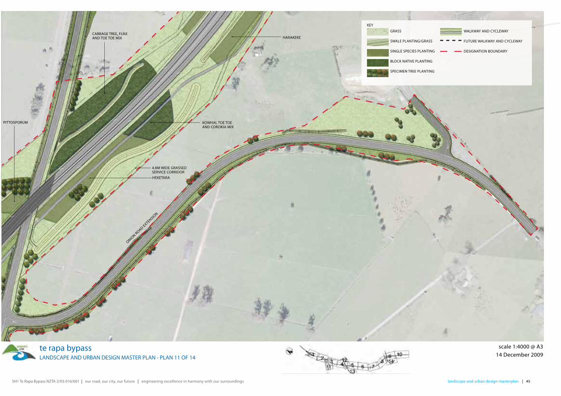
te rapa bypass LANDSCAPE AND URBAN DESIGN MASTER PLAN - PLAN 11 OF 14
ONION ROAD EXTENSIO
N
landscape and urban design masterplan | 45
4.8M WIDE GRASSED SERVICE CORRIDOR
PITTOSPORUM
CABBAGE TREE, FLAXAND TOE TOE MIX
KOWHAI, TOE TOEAND COROKIA MIX
HEKETARA
HARAKEKE
GRASS
SWALE PLANTING/GRASS
SINGLE SPECIES PLANTING
BLOCK NATIVE PLANTING
SPECIMEN TREE PLANTING
KEY
WALKWAY AND CYCLEWAY
FUTURE WALKWAY AND CYCLEWAY
DESIGNATION BOUNDARY
landscape and urban design masterplan | 46SH1 Te Rapa Bypass NZTA 2/03-016/601 | our road, our city, our future | engineering excellence in harmony with our surroundings
scale 1:4000 @ A314 December 2009
te rapa bypass LANDSCAPE AND URBAN DESIGN MASTER PLAN - PLAN 12 OF 14
CAREX
HARAKEKE
TOTARA, KARAMU AND MUEHLENBECKIA MIX
CABBAGE TREE, HARAKEKEAND TOE TOE MIX
TOE TOE
KOWHAI, TOE TOEAND COROKIA MIX
CAREX
MUEHLENBECKIA
GRASS
SWALE PLANTING/GRASS
SINGLE SPECIES PLANTING
BLOCK NATIVE PLANTING
SPECIMEN TREE PLANTING
KEY
WALKWAY AND CYCLEWAY
FUTURE WALKWAY AND CYCLEWAY
DESIGNATION BOUNDARY
SH1 Te Rapa Bypass NZTA 2/03-016/601 | our road, our city, our future | engineering excellence in harmony with our surroundings
scale 1:4000 @ A314 December 2009
te rapa bypass LANDSCAPE AND URBAN DESIGN MASTER PLAN - PLAN 13 OF 14
GRASS
SWALE PLANTING
SWALE GRASS
SINGLE SPECIES PLANTING
BLOCK NATIVE PLANTING
EXOTIC NODE PLANTING
KEYPEDESTRIAN WALKWAY AND CYCLEWAY
(3M WIDE)
FUTURE PEDESTRIAN WALKWAY AND
CYCLEWAY (3M WIDE)
DESIGNATION BOUNDARY
landscape and urban design masterplan | 47
CAREX
MUEHLENBECKIA
CAREX
MUEHLENBECKIA
TOE TOETOTARA, KARAMU AND MUEHLENBECKIA MIX
GRASS
SWALE PLANTING/GRASS
SINGLE SPECIES PLANTING
BLOCK NATIVE PLANTING
SPECIMEN TREE PLANTING
KEY
WALKWAY AND CYCLEWAY
FUTURE WALKWAY AND CYCLEWAY
DESIGNATION BOUNDARY
landscape and urban design masterplan | 48SH1 Te Rapa Bypass NZTA 2/03-016/601 | our road, our city, our future | engineering excellence in harmony with our surroundings
scale 1:4000 @ A314 December 2009
te rapa bypass LANDSCAPE AND URBAN DESIGN MASTER PLAN - PLAN 14 OF 14
GRASS
SWALE PLANTING
SWALE GRASS
SINGLE SPECIES PLANTING
BLOCK NATIVE PLANTING
EXOTIC NODE PLANTING
KEYPEDESTRIAN WALKWAY AND CYCLEWAY
(3M WIDE)
FUTURE PEDESTRIAN WALKWAY AND
CYCLEWAY (3M WIDE)
DESIGNATION BOUNDARY
LOMANDRAKOWHAI, TOE TOE AND COROKIA MIX
CABBAGE TREE, FLAX AND TOE TOE MIX
GRASS
SWALE PLANTING/GRASS
SINGLE SPECIES PLANTING
BLOCK NATIVE PLANTING
SPECIMEN TREE PLANTING
KEY
WALKWAY AND CYCLEWAY
FUTURE WALKWAY AND CYCLEWAY
DESIGNATION BOUNDARY
landscape and urban design masterplan | 49SH1 Te Rapa Bypass NZTA 2/03-016/601 | our road, our city, our future | engineering excellence in harmony with our surroundings lllala ddndndscscapape e ananddd d ururbbbaban n dddede iisisigngn m masasttteterprplllalann | 49SH1 Te Rapa Bypass NZTA 2/03-016/601 | our road, our city, our future | engineering excellence in harmony with our surroundings
6.1 Cross Sections
TYPICAL CROSS SECTION - 5/10 YEAR PLANTING > 1:4
TYPICAL CROSS SECTION - WALKWAY AND CYCLEWAY NODE AREA
landscape and urban design masterplan | 50SH1 Te Rapa Bypass NZTA 2/03-016/601 | our road, our city, our future | engineering excellence in harmony with our surroundings ll l lanandddsdscacapepe a a ddndnd u u bbrbrbanan dd d desesiiigign n mama ttststerer llplplanan | 50SH1 Te Rapa Bypass NZTA 2/03-016/601 | our road, our city, our future | engineering excellence in harmony with our surroundings
TYPICAL CROSS SECTION - PLANTING/FUTURE DEVELOPMENT
LOCAL BRIDGE SKETCH
landscape and urban design masterplan | 51SH1 Te Rapa Bypass NZTA 2/03-016/601 | our road, our city, our future | engineering excellence in harmony with our surroundings lllala ddndndscscapape e ananddd d ururbbbaban n dddede iisisigngn m masasttteterprplllalann | 51SH1 Te Rapa Bypass NZTA 2/03-016/601 | our road, our city, our future | engineering excellence in harmony with our surroundings
7 ARTS INTEGRATION IN THE DESIGNS
Our approach has been to:
• Design a simple solution which relates to its setting and to its present function, which is entire in its own right,
• Avoid specifi c theming of structures, as each bridge relates to a diff erent function,
• Provide a framework which can be adapted over time to the changing surrounding environment, avoiding treatments which may become outdated as time passes,
• Engage with council, iwi again at the next stage, to see where joint action may progress community led aspirations,
• Identify opportunities for inclusion of site specifi c events to celebrate the community’s ownership of place.
Future Art InterventionWhile specific art interventions are excluded from this project, we have identified certain themes and potential locations for integrated art work which can be developed at a later stage.
While there is an opportunity to identify areas for inclusion of arts intervention, this has not been seen as a key component of the scheme at this stage. There is no evidence of programme or funding for individual art intervention in council budgets, which could be applied to this project. This possibility of sponsored funding is a topic which can be further investigated in conjunction with council.
As the urban area grows, the urban/rural boundaries change and land use intensifies, it will be appropriate to investigate ways in which the community can put their mark on locations, and further develop their sense of place. The proposed framework allows for this but does not predetermine community choice and outcomes. Any brief for integrated art work will be consistent with the themes of the landscape and urban design master plan, integrated with the local landscape and drawing on local materials. The use of vertical elements will be encouraged to strengthen the use of bold simple planting in linear patterns. Vertical elements will also act as marker indicators in the landscape.
Issues which have been considered initially include:
• marking the east west/north south crossing of routes, at the Central Road intersection, already identifi ed by iwi, as of signifi cance. This proposal would complement the Hamilton Gateway Strategy,
• interpretive signage/installations at the nodes along the pedestrian walkway/cycleway which will be an integral part of the green corridor open space, with community input,
• liaison with Wintec for their involvement with the Gilchrist Road intersection, which becomes the main entry point to Wintec, and where the campus boundary is a feature of the roading network.
We will develop this approach at the next stage by:
• working closely with HCC on opportunities for arts interpretation and sponsorship which fi t within their programme,
• presenting our design to HCC urban design panel for review and commencement of a detailed design dialogue in fi ne tuning the project,
• walking the site and liaising with iwi to further engage with stories of the land, in particular the opportunity for placement of pou at the central road intersection and the naming of the land,
• developing an Arts framework brief for future use.
landscape and urban design masterplan | 52SH1 Te Rapa Bypass NZTA 2/03-016/601 | our road, our city, our future | engineering excellence in harmony with our surroundings ll l lanandddsdscacapepe a a ddndnd u u bbrbrbanan dd d desesiiigign n mama ttststerer llplplanan | 52SH1 Te Rapa Bypass NZTA 2/03-016/601 | our road, our city, our future | engineering excellence in harmony with our surroundings
8. PLANTING MANAGEMENT AND MAINTENANCE
8.1 Planting Management and Maintenance
A landscape maintenance manual will be developed during the detailed design phase to guide the ongoing establishment of the green corridor. As the management function of the road may change in the future, requirements of NZTA, HCC and WDC have been considered in developing the design.
The maintenance manual will address all landscape maintenance aspects from initial construction and will cover ten years of maintenance.
Maintenance ManualThe key documents to be compiled within the maintenance manual include;
Specifi cation: This will take account of NZTA “Guidelines for Highway Landscaping”, the Principals Requirements for this Project and detailed treatments specific to establishing healthy growing conditions in the local environment.
The key items will include:• site preparation, vegetation removal, soil
stripping and storage, plus weed control,
• topsoil quality, testing, soil handling and depth,
• plant material, including plant sourcing and supply, plant quality, storage and planting techniques for shrubs and trees plus any auxiliary requirements such as fertilisation and staking shall also be covered in detail,
• mulch materials, source, spread and fi xing requirements and ancillary products where necessary,
• Pest control; specifi c control measures shall be instigated for control of rabbits and possum and where pukeko damage is likely to occur plants shall be secured with biodegradable pins,
• 2 year defects liability maintenance period, covering establishment period, weed removal, plant replacement and coverage requirements.
Installation shall meet the Principal’s Requirements, including ripping of sub base, spread of topsoil to the required depths for planting and grassing (300mm/100mm), and the cover of planted areas with 100mm of organic mulch. Topsoil will be that sourced from site.
Planting has been designed to achieve average spacing, required by the PRs. Two sizes of plants are proposed being Pb3 for all mass planting, and Pb95 for specimen trees, which shall be double staked and tied. All plants shall be ecosourced from seed sources from locations as close as possible to the site.
Within the specification, the defects maintenance and liability period for years 1 to 2 shall be covered with the scope including; required establishment rates, pest and weed control, top up of well rotted bark mulch, plus herbicide spraying standards and plant replacement. Within the defects specification a minimum of number 12 visits per annum will be stipulated along with reporting procedures and outline the use of the pro-forma check lists.
Risk Assessment and Hazard Identifi cation Report:This will identify potential risks to landscape operatives and the public in relation to the implementation and maintenance of the proposed landscape scheme. The principal hazards shall be identified with control measures indicated to assist in the management and reduction of site injury.
Maintenance Specifi cations for Years 2 to 5 and 5 to 10Landscape management specifications shall be developed to cover years 2 to 5 and 5 to 10. These specifications shall cover the aspirations for the project and desired outcomes and standards to be achieved during these periods which will be in line with NZTA guidelines. The maintenance specification shall cover aspects of weed and pest control, replacement planting, plant maintenance, pruning techniques and requirements, plus disease management. The specifications will also outline the management
of plant areas and removal of excess growth, establishment of non specified native species within the planting mixes and management of adventives weed species. The specifications will incorporate maintenance pro-formas to record maintenance activity, site conditions, disease and pest attacks and management techniques utilised, which shall be utilised as part of the monitoring program.
Summary maintenance operation schedules shall also be developed, which shall identify key operations and when they are to be carried out and where necessary a brief outline of the requirements.
Pro-forma check listsPro-forma check lists shall be developed for contractor use, to record information during the construction period and for maintenance inspections to ensure suitable standards and visit frequencies are being implemented. The pro-formas shall form part of the maintenance specification and shall outline the performance criteria required. The key items that shall be covered within the pro-formas will include but not be limited to; site visit conditions, grass management and mowing schedules, shrub and tree management including failures and replacement, weed control and management, soil and mulch maintenance, fertiliser application records, pesticide use and management, litter levels and management, and hazard identification and management.
landscape and urban design masterplan | 53SH1 Te Rapa Bypass NZTA 2/03-016/601 | our road, our city, our future | engineering excellence in harmony with our surroundings lllala ddndndscscapape e ananddd d ururbbbaban n dddede iisisigngn m masasttteterprplllalann | 53SH1 Te Rapa Bypass NZTA 2/03-016/601 | our road, our city, our future | engineering excellence in harmony with our surroundings
Riparian Management PlansThe aim of the riparian management plans will be to ensure the diversity of habitat exists within the swale/riparian zone areas at any one time. Generally, the riparian areas will be implemented as self sustaining, with allowance for establishment of non specified native species to establish over time. However, to ensure the aim of habitat diversity is achieved, specific riparian management plans shall be developed to cover aspects of plant establishment and weed monitoring and management. Longer term management regimes will cover weed management, plant replacement and clearance of over grown swales to ensure a balance of riparian planting occurs.
Vegetation Management PlansDiagrammatic vegetation plans shall be included within the Maintenance Manual, which shall identify areas of planting with species plus provide a key for the short and long term maintenance and management requirements. The management plans shall also include information of grassed areas, including species and any mowing requirements. The vegetation management plans shall be referenced to the landscape maintenance specification where possible to provide a robust and maintenance manual which is easily referenced.
Environmental Mitigation and Monitoring SchedulesEnvironmental mitigation and monitoring schedules shall be developed for the project to allow monitoring during the construction period and for a 10 year period after construction. The mitigation and monitoring schedules shall tie into the consent requirements for the project to ensure compliance is achieved.
The schedules shall cover frequency of monitoring and may include the following aspects; vegetation removal, vegetation establishment, plant growth and coverage, weed control and maintenance requirements.
Fulton Hogan SH20 Landscape Construction
landscape and urban design masterplan | 54SH1 Te Rapa Bypass NZTA 2/03-016/601 | our road, our city, our future | engineering excellence in harmony with our surroundings ll l lanandddsdscacapepe a a ddndnd u u bbrbrbanan dd d desesiiigign n mama ttststerer llplplanan | 54SH1 Te Rapa Bypass NZTA 2/03-016/601 | our road, our city, our future | engineering excellence in harmony with our surroundings
9. APPENDICES
9.1 Planting Schedule
SINGLE PLANTING SPECIESBotanical Name Common Name Grade Spacing % Mix Quantity
landscape and urban design masterplan | 55SH1 Te Rapa Bypass NZTA 2/03-016/601 | our road, our city, our future | engineering excellence in harmony with our surroundings lllala ddndndscscapape e ananddd d ururbbbaban n dddede iisisigngn m masasttteterprplllalann | 55SH1 Te Rapa Bypass NZTA 2/03-016/601 | our road, our city, our future | engineering excellence in harmony with our surroundings
EXOTIC TREE PLANTING SPECIESBotanical Name Common Name Grade Spacing % Mix Quantity
(centers)Fraxinus excelsior Ash PB95 as shown n/a 200Quercus palustris Pin oak PB95 as shown n/a 200Quercus robur 'Fastigiata' Upright Oak PB95 as shown n/a 200Platanus x hispanica London Plane PB95 as shown n/a 200Tilia platyphyllos 'Laciniata' Upright Silver
LindenPB95 as shown n/a 200
SWALE/WETLAND PLANTINGBotanical Name Common Name Grade Spacing % Mix Quantity
landscape and urban design masterplan | 56SH1 Te Rapa Bypass NZTA 2/03-016/601 | our road, our city, our future | engineering excellence in harmony with our surroundings ll l lanandddsdscacapepe a a ddndnd u u bbrbrbanan dd d desesiiigign n mama ttststerer llplplanan | 56SH1 Te Rapa Bypass NZTA 2/03-016/601 | our road, our city, our future | engineering excellence in harmony with our surroundings
10. BIBLIOGRAPHY
N.O.R Consent Conditions, 2008The Project Environmental Management PlanNZTA Urban Design Policy, 2007Rotokauri Structure Plan - Hamilton City Council, 2007Draft Horotiu Structure Plan Discussions - Waiakto District Council, 2009Draft Walkway and Cycling Strategy Te Rapa Bypass - BBO 2009Lake Waiwhakareke Landscape Character Area Plant ListWaiwhakareke Natural Heritage Park Management PlanNZTA Guidelines for Highway Landscaping, 2007, Version 2HCC Design Guide VISTAEnvironment Waikato Plant Pest Management StrategyDraft Proposed City Gateway Policy – Hamilton City Council 2009Road Reserve Planting Strategy – Hamilton City Council 2007Urban Design Protocol – Ministry for the Environment 2004